Be advised that the NPS has issued alerts for this park.
Timed Entry Reservation Pilot 2025
To enter the park April 1–July 6 and August 28–October 31, 2025, most visitors will need a Timed Entry Ticket. Tickets may be purchased from Recreation.gov up to six months ahead. Extra tickets release at 7pm nightly for next-day visits.
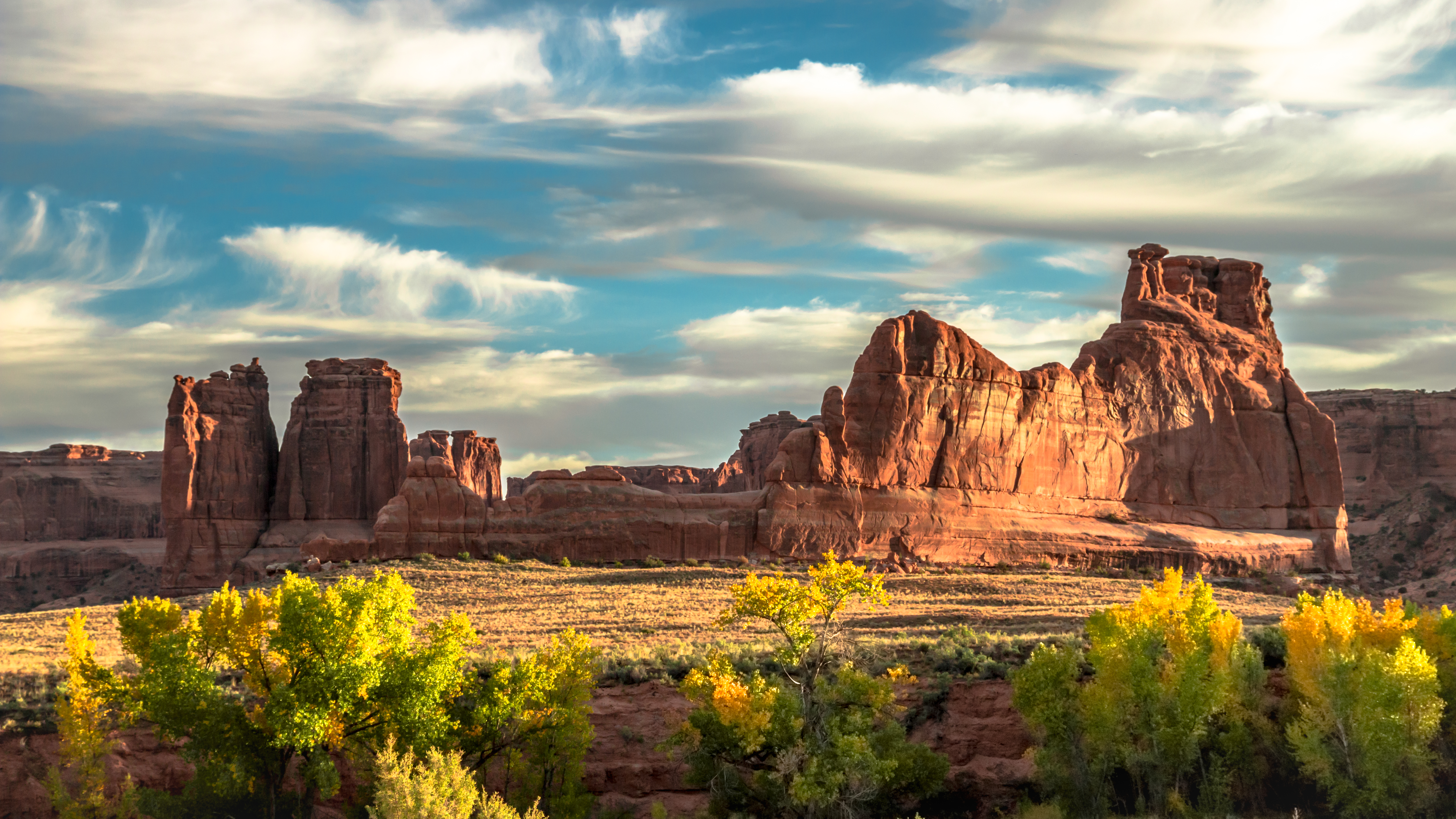
Discover a landscape of contrasting colors, land forms, and textures unlike any other. The park has over 2,000 natural stone arches, hundreds of soaring pinnacles, massive rock fins, and giant balanced rocks. This red-rock wonderland will amaze y...
From April 1 through July 6, 2025, visitors entering the park in a vehicle between 7 am and 4 pm will need to have already purchased a Timed Entry Ticket from Recreation.gov before arriving. One ticket is needed per vehicle. This fee is a Recreation.gov service charge, so it is not waived by any of the interagency passes.
Entrance - Private Vehicle
$30.00
Admits one private, non-commercial vehicle (15 passenger capacity or less) and all its occupants.
Entrance - Motorcycle
$25.00
Admits one private, non-commercial motorcycle and its riders
Entrance - Per Person
$15.00
Admits one individual with no car. Typically used for bicyclists, hikers, and pedestrians. Youth 15 and under are admitted free.
Timed Entry Reservation - Park
$2.00
From August 28 through October 31, 2025, visitors entering the park in a vehicle between 7 am and 4 pm will need to have already purchased a Timed Entry Ticket from Recreation.gov before arriving. One ticket is needed per vehicle. This fee is a Recreation.gov service charge, so it is not waived by any of the interagency passes.
You can reserve campsites for nights between March 1 and October 31. Between November 1 and February 28, all sites are first-come, first served. Reservations for both group and individual sites can be made below or by calling Recreation.gov at 1-877-444-6777. The earliest you can make reservations for standard sites is 10 am eastern time, six months in advance. The latest you can make reservations is four days in advance. You can reserve group sites up to 12 months in advance. The campground has two sites for groups of 11 or more people. Juniper Basin campsite accommodates up to 55 people and is available March 1 to October 31; Canyon Wren campsite accommodates up to 35 and may be reserved year-round. No RVs or trailers are permitted in the group sites.
Audio description of Arches Visitor Center Zone 1- Water Filling Station
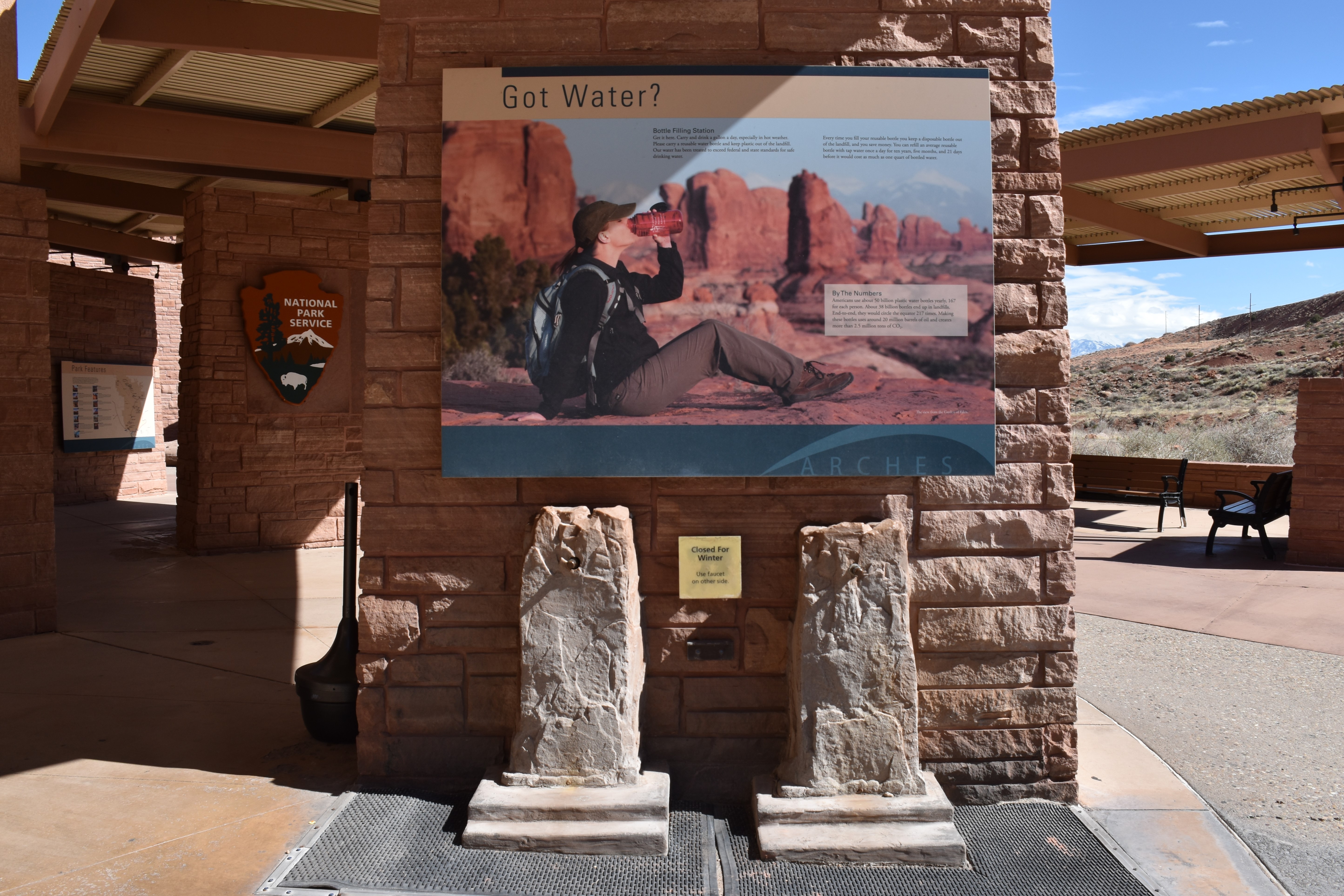
Exterior Zone 1 Menu Got Water? 313 words. Water: Our Essence. 492 words. Navigation to Exterior Zone 2, Park Features. 54 words. [1a] Got Water? Got Water? 313 words. 4 sections. This exhibit emphasizes the importance of drinking water and reusable bottles. Two panels are located on each side of the first display partition on your left as you enter. The front panel, which overlooks the parking lot, features a large photo of a female hiker outfitted in hiking gear and a pack, sitting in profile on red rocks. Behind her, a vista of rocks and arches glow against snow-covered peaks in the distance. She drinks from a reusable water bottle. Caption reads: The view from the Garden of Eden. End of section. The panel, located above two spigots for filling water bottles, titled Got Water? reads: Bottle Filling Station. Get it here. Carry and drink a gallon a day, especially in hot weather. Please carry a reusable water bottle and keep plastic out of the landfill. Our water has been treated to exceed federal and state standards for safe drinking water. Every time you fill your reusable bottle you keep a disposable bottle out of the landfill, and you save money. You can refill an average reusable bottle with tap water once a day for ten years, five months, and 21 days before it would cost as much as one quart of bottled water. End of section. A small inset section, titled By the Numbers, reads: Americans use about 50 billion plastic water bottles yearly. 167 for each person. About 38 billion bottles end up in landfills. End-to-end, they would circle the equator 217 times. Making these bottles uses around 20 million barrels of oil and creates more than 2.5 million tons of CO2. End of section. The water spigots on this side may be turned off during winter. If so, use the spigots on the other side. Move to the opposite side of the partition to learn more about water and its importance. End of description. [1b] Water: Our Essence Water: Our Essence. 492 words. 6 sections. In front of this panel and slightly to the right is a frost-free faucet at the top of a pipe rising from ground level over a grate. The left side of this panel is dominated by a cartoon image of a grave and headstone with rock formations in the background. A vulture is perched on the headstone. The stone is carved with the words: Here lies Peter. He drank only one liter. The cartoon caption reads: Drink more water! Below is a photograph of a variety of beverages, a cup of coffee, two beer bottles, and three cans, all set against red stone. The accompanying text reads: Warning! Caffeine and alcohol actually deplete your body of water! End of section. The panel, titled Water: Our Essence, begins with text: During the course of a day, a healthy adult can lose 8 to 10 cups of water, and that’s without hiking in the hot sun. We must keep replenishing our most important nutrient: water. Water makes up about 75% of our muscles, brains, and blood. Though the plants and animals here are well adapted to a life with little moisture, humans react with serious symptoms after losing only two percent of our body’s water. Total collapse occurs with only a seven percent water loss. End of section. A subtitled section, titled Dehydration: Early Symptoms, reads: Headache, stomachache, weakness, dizziness, dry lips, and thirst are all early symptoms of dehydration. Thirst is not always the first sign, so drink water even if you’re not thirsty. An inset section asks: How much is enough? On average a person needs one gallon of water per day. You may need more if you’re doing strenuous exercise in hot weather. Can I drink too much? Yes, but it takes a lot. While drinking too much can be a problem, not drinking enough is a bigger problem! End of section. A highlighted section of the panel announces: Drinking water is available only at two locations in this park. Here at the visitor center, from the spigots below or on the other side of the pillar, and at Devils Garden, near the end of the road 18 miles from here. Fill your water bottles, canteens, and jugs now. End of section. To the right is a list of Water Facts: 1. The largest number of preventable park medical emergencies stem from dehydration. 2. Early signs of dehydration include headaches, nausea, lethargy, and fatigue. 3. Water is available only at two locations within the park: here and Devils Garden. 4. Two percent water loss is serious dehydration. 5. Seven percent water loss is total collapse. End of section. A set of accompanying graphics depict gallons, quarts, and liters. Pictures show the relationships of those quantities, mirroring the text: One gallon equals four 32-ounce water bottles or eight 16-ounce water bottles. One gallon equals 3.6 one-liter bottles. One quart equals 0.91 liter. End of description. [1c] Navigation to Exterior Zone 2, Park Features Navigation to Exterior Zone 2, Park Features. 54 words. From the Water exhibit, move back to the walkway and proceed past the Park Identity partitions on both sides. The next partition on your left begins Exterior Zone 2, Park Features. A bench may be available adjacent to the partition facing this exhibit. End of description.
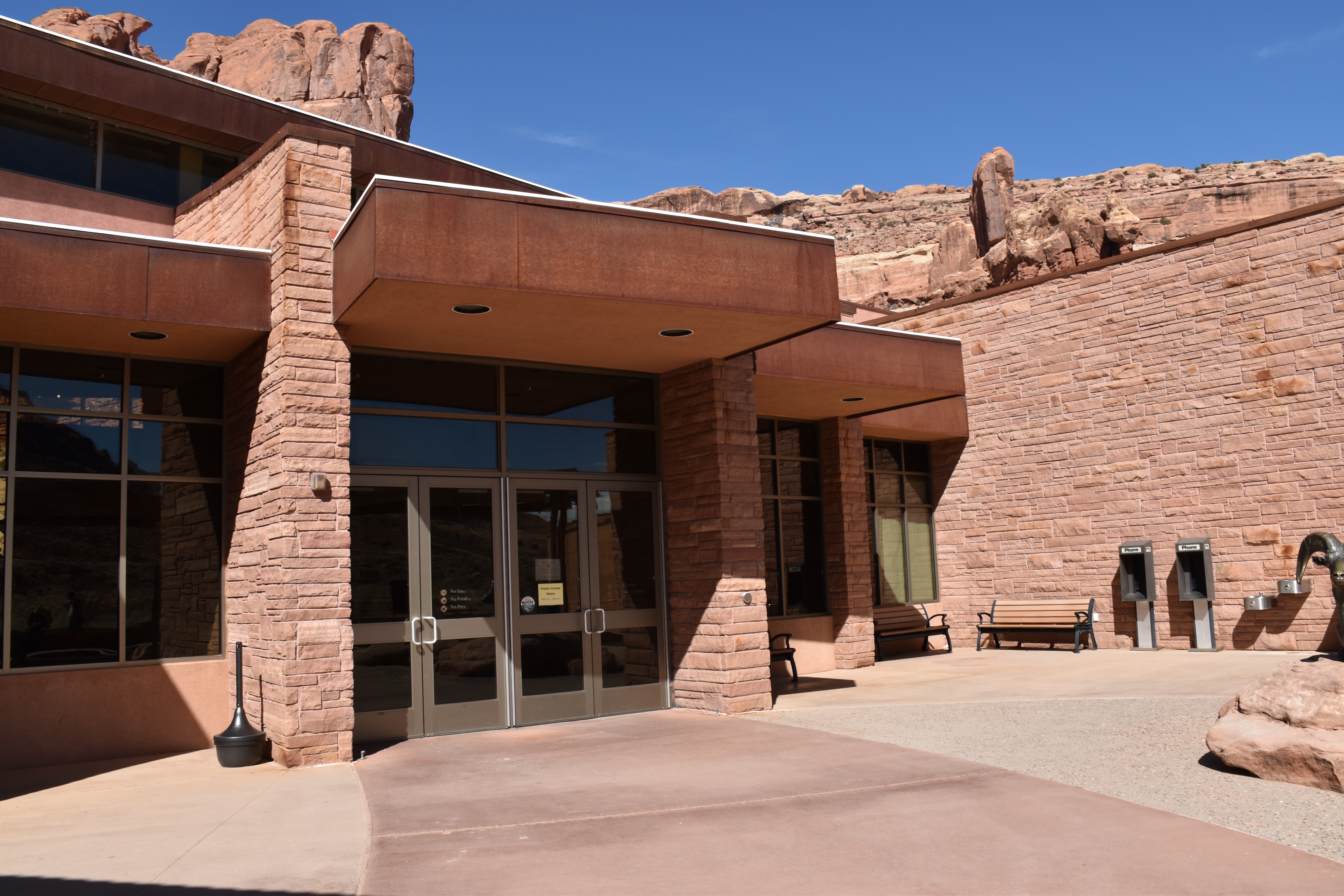
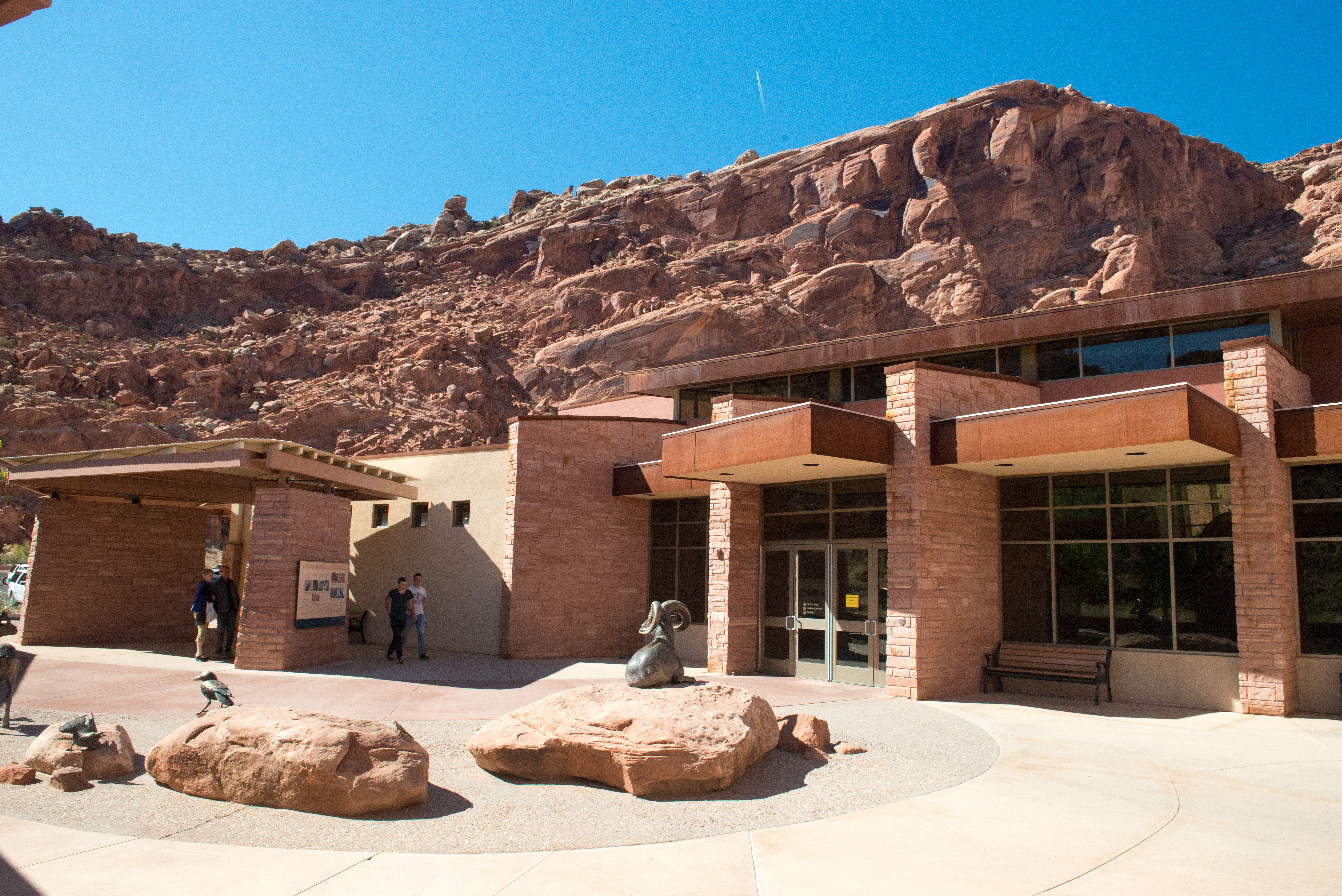
Orientation to Visitor Center Entrance overview. 376 words. 4 sections. This zone will describe the last section of the walkway, point out specific features, and guide the visitor through the entrance into the indoor exhibit facility. From the walkway between the Arches Wildlife panels and the animal sculptures, you can move toward the entrance of the Visitor Center directly. To your right, as you make your way to the entrance, in the middle of the red stone brick wall, is the foyer for facility restrooms: men's room is the first door on the left, women's room is the second on the left, and the family restroom entrance is on the right side of the foyer. Along the wall to the left side of the restroom foyer entrance are trash cans, two water fountains, the remains of two public phone booths, and benches. End of section. From the walkway, as you reach the entrance, there is a cigarette disposal to your left. The entry is made up of two sets of double doors. On the doorframe to your right is an accessibility push-button, which automatically opens the right door. A warning sign on the door indicates No Smoking; No Food or Drinks; No Pets; No Firearms. End of section. When you enter the first set of doors into the entrance foyer, the ground texture changes from concrete to carpet. Another automatic door opener push-button is at the center of the wall to your right. When you enter the second set of doors, the floor texture changes from carpet to smooth interior concrete. End of section. Upon entering the facility, you will encounter a textured relief map set within a seven-foot square, two-foot-tall box. Behind the large box is a giant image of Delicate Arch. The ranger desk can be found on the wall to your right and the park store is to your left. To learn more about the Visitor Center’s interior and its exhibits, access the Arches Visitor Center Interior Audio Description tour within this app. As a reminder, here are the instructions. 1. Open the top-right 3-dot slide-out menu. 2. Tap "Audio Description and Tours." 3. Tap "Audio Description Tours." 4. Scroll down to find the park name and tap that. End of description.
Featured outside of the Arches National Park Visitor Center
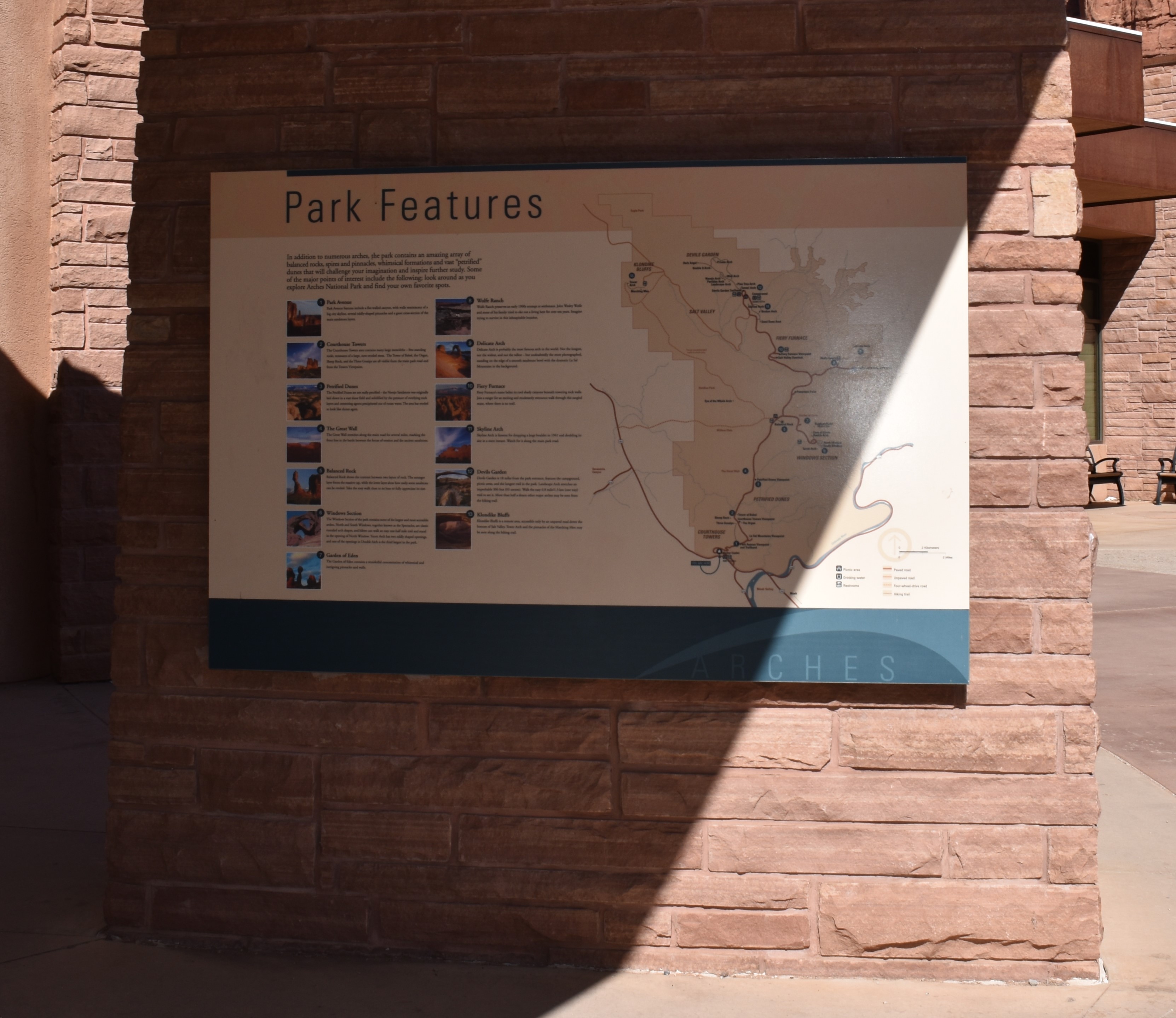
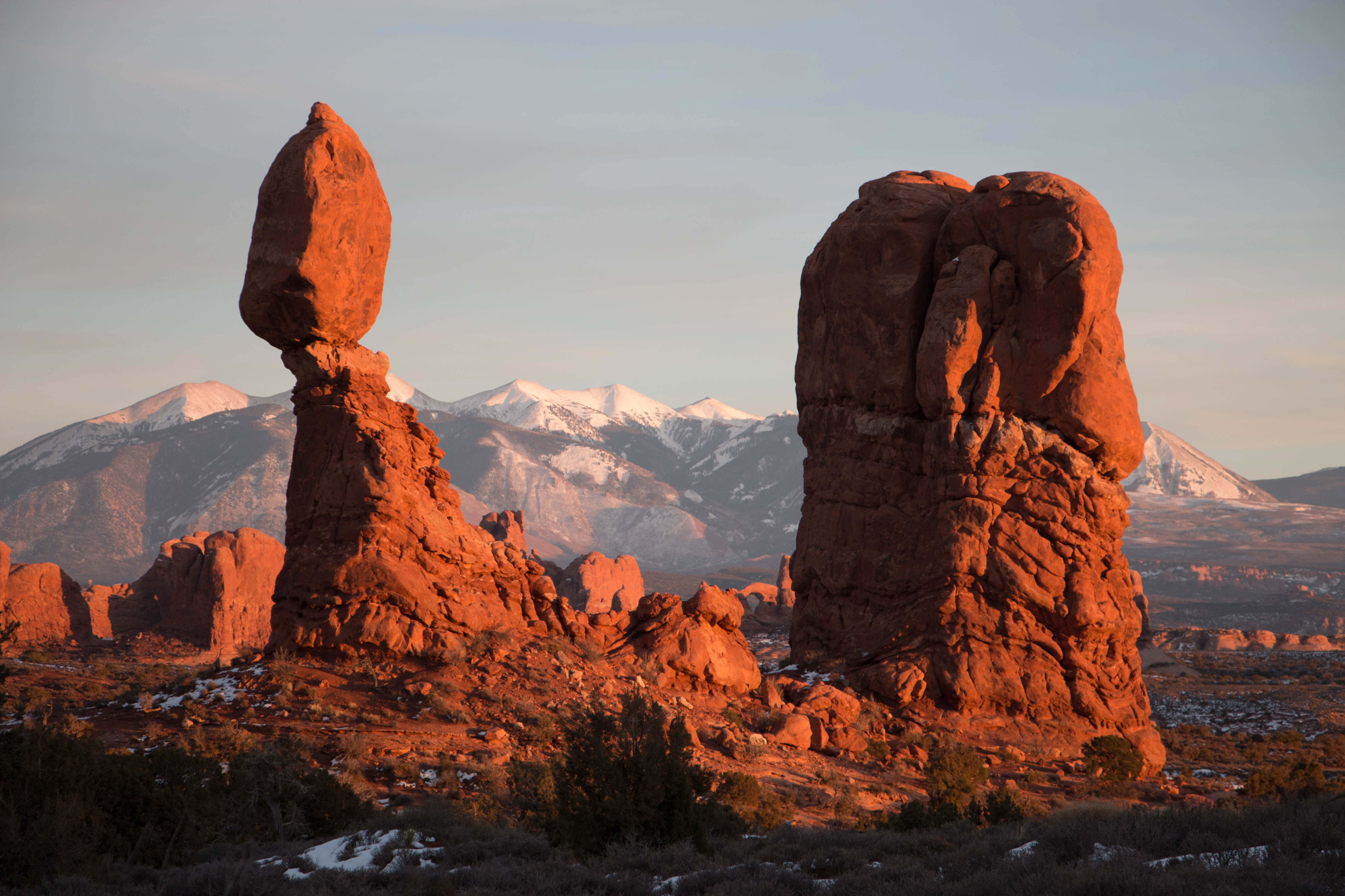
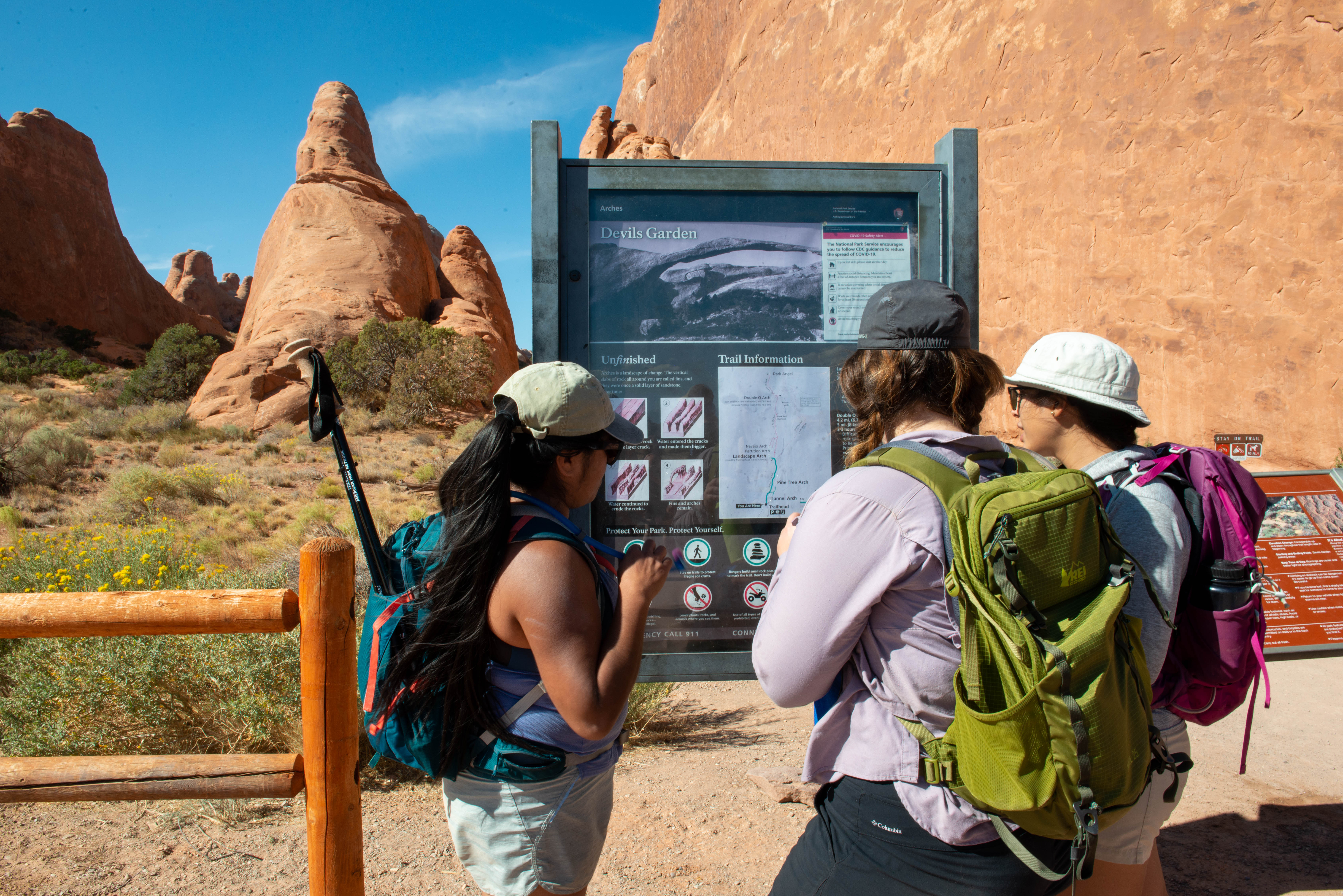
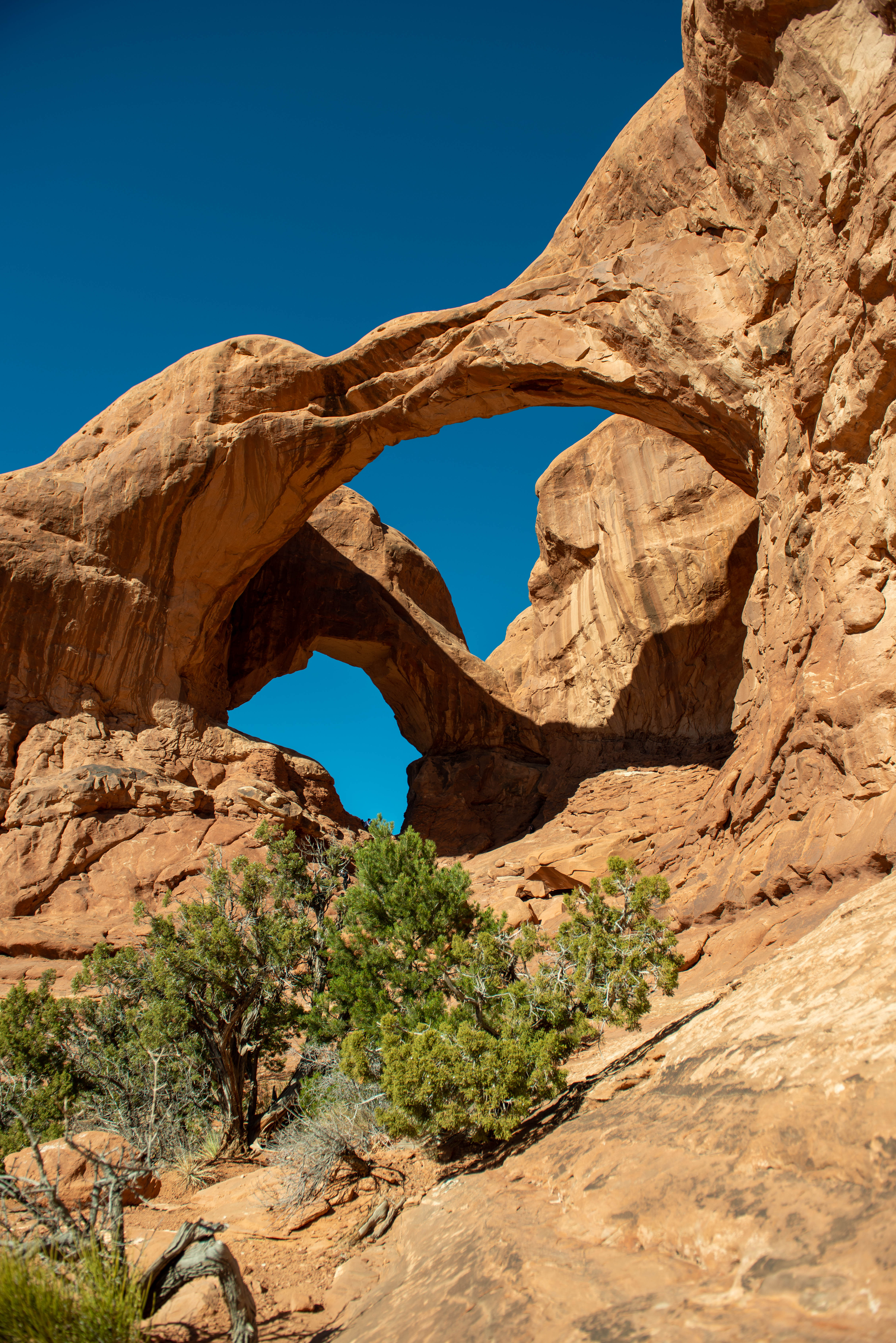
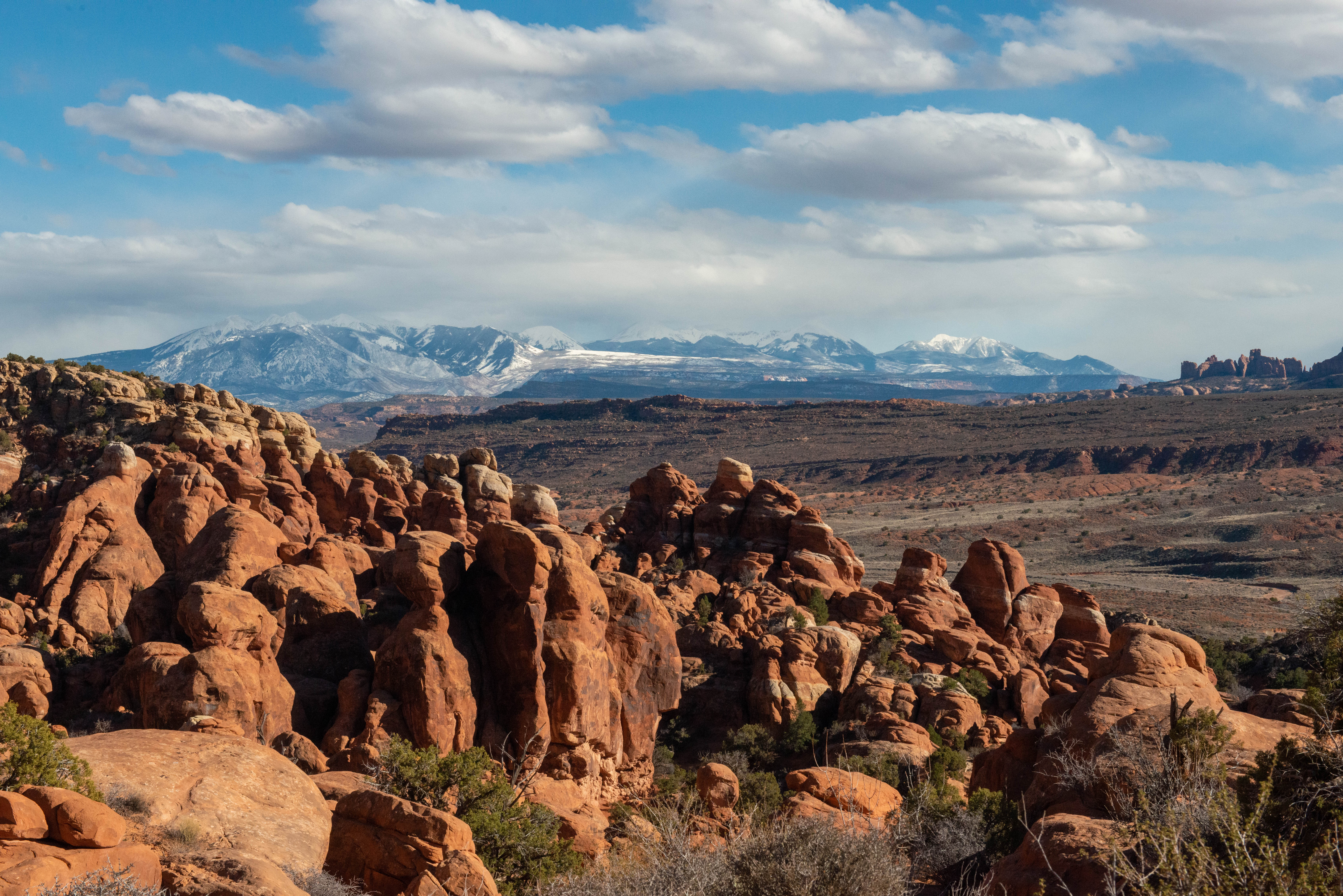
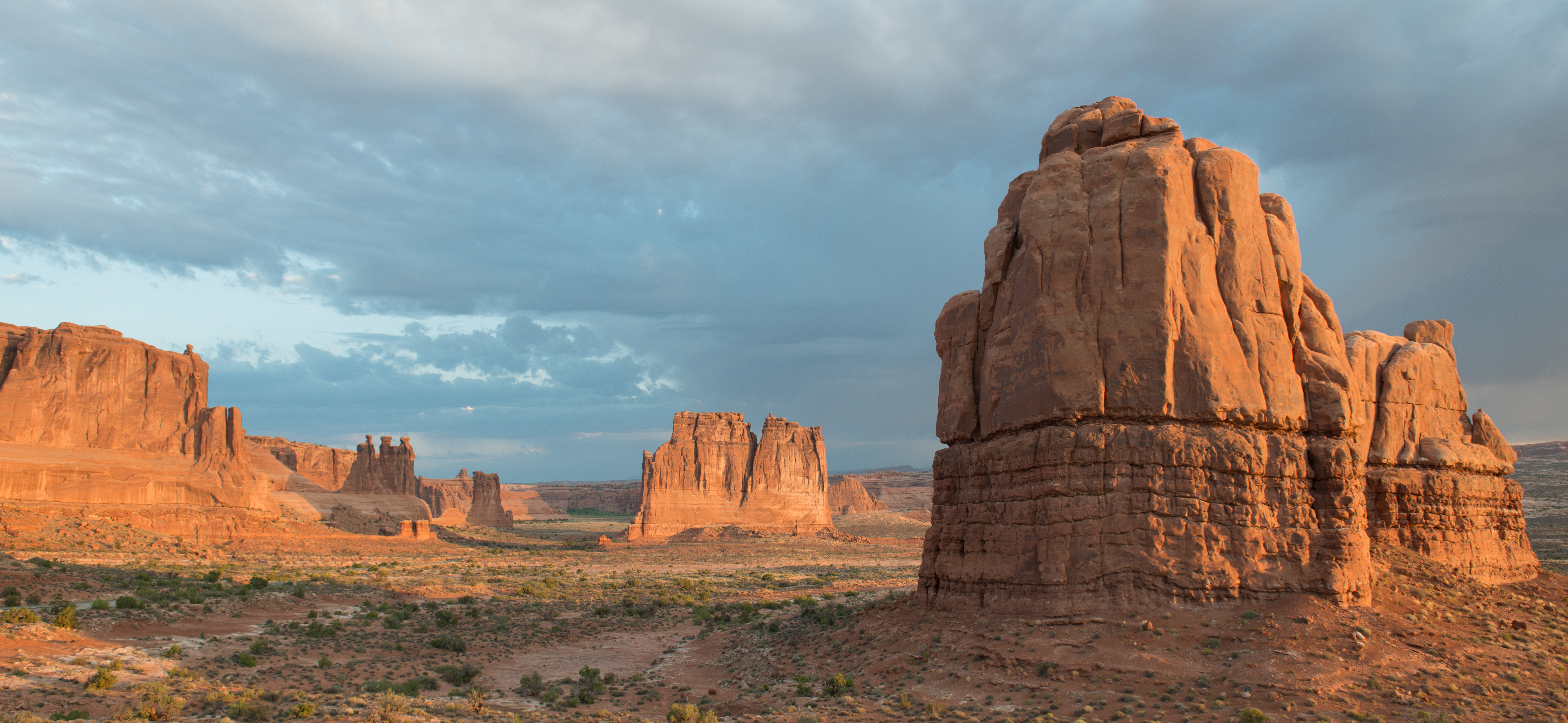
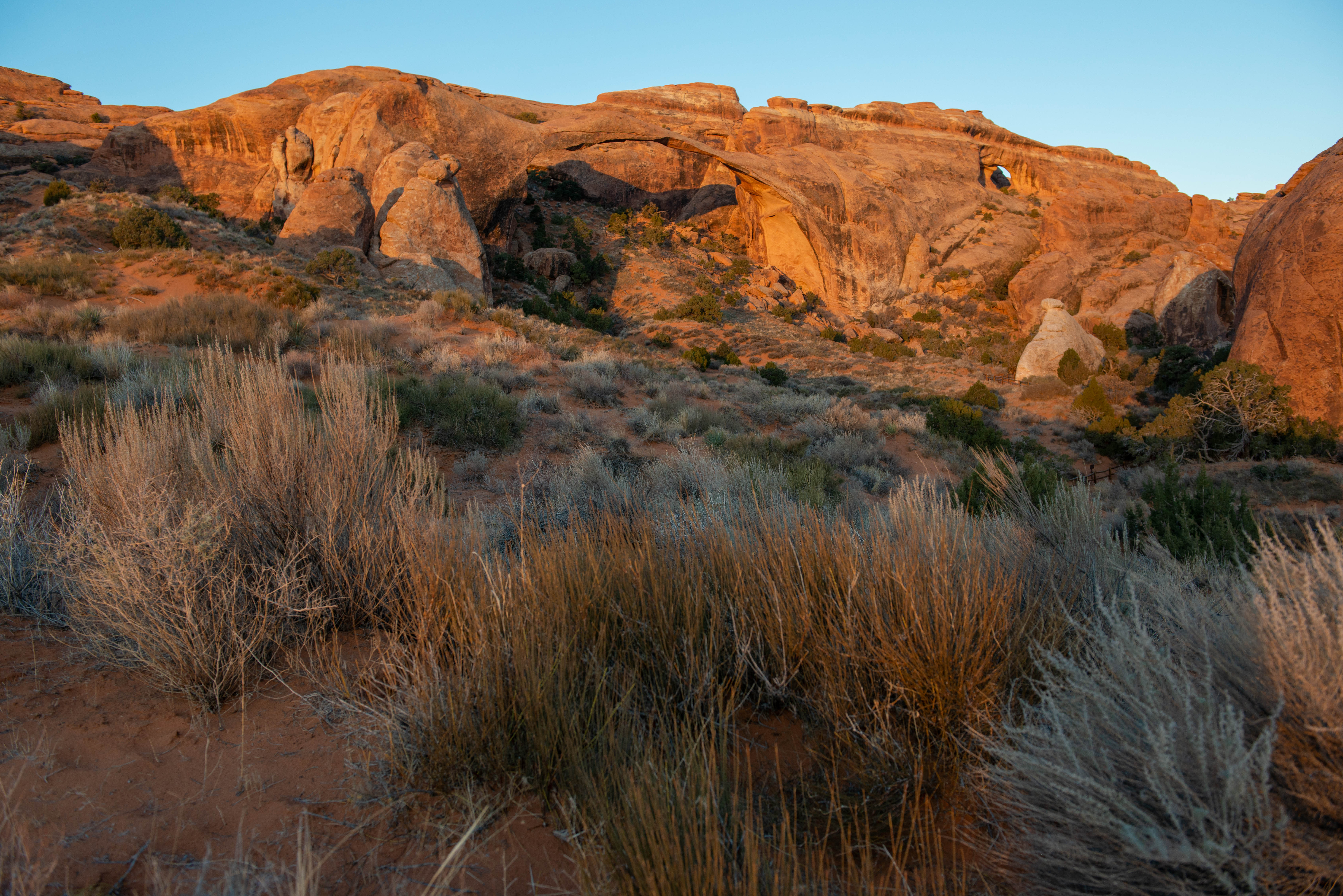
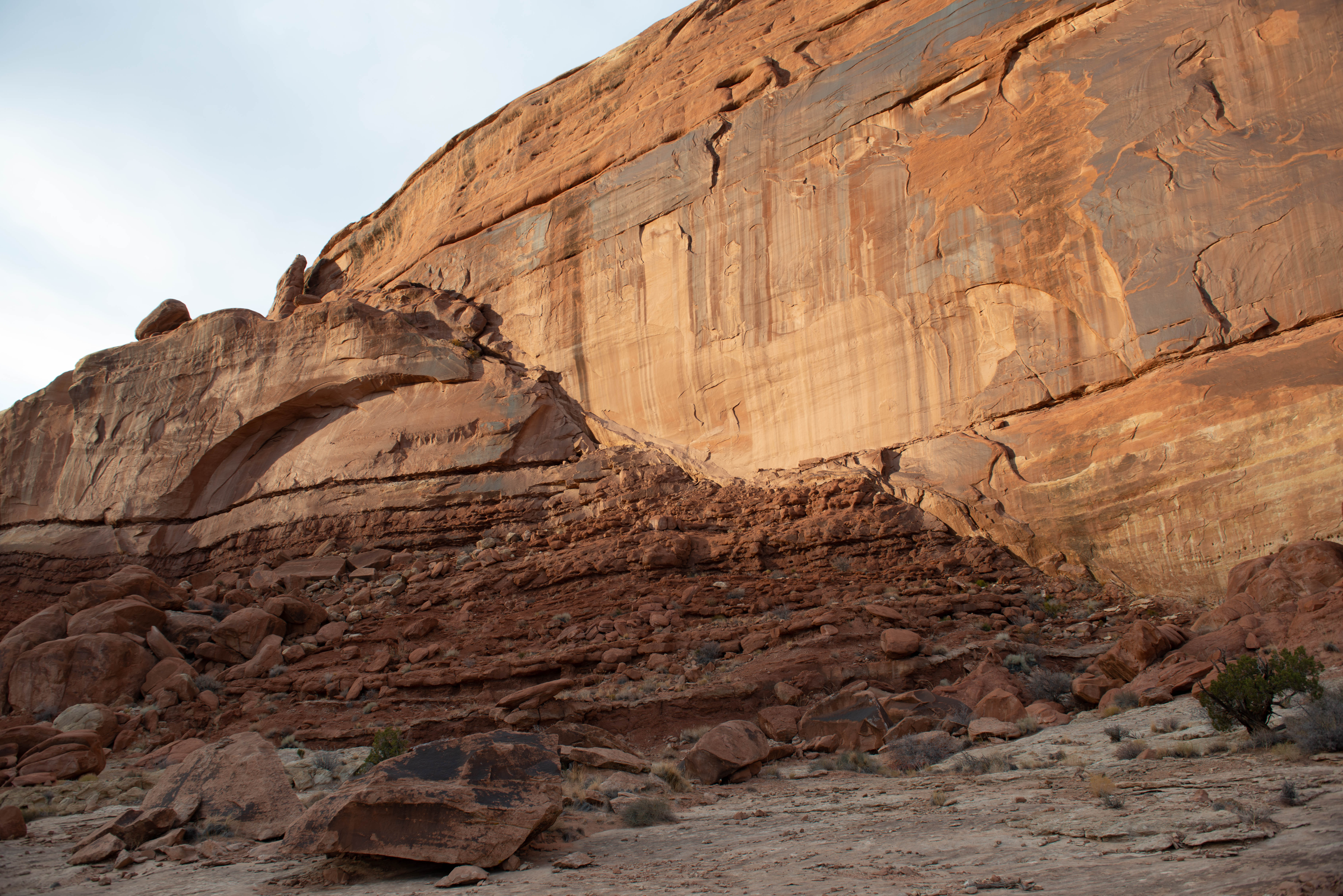
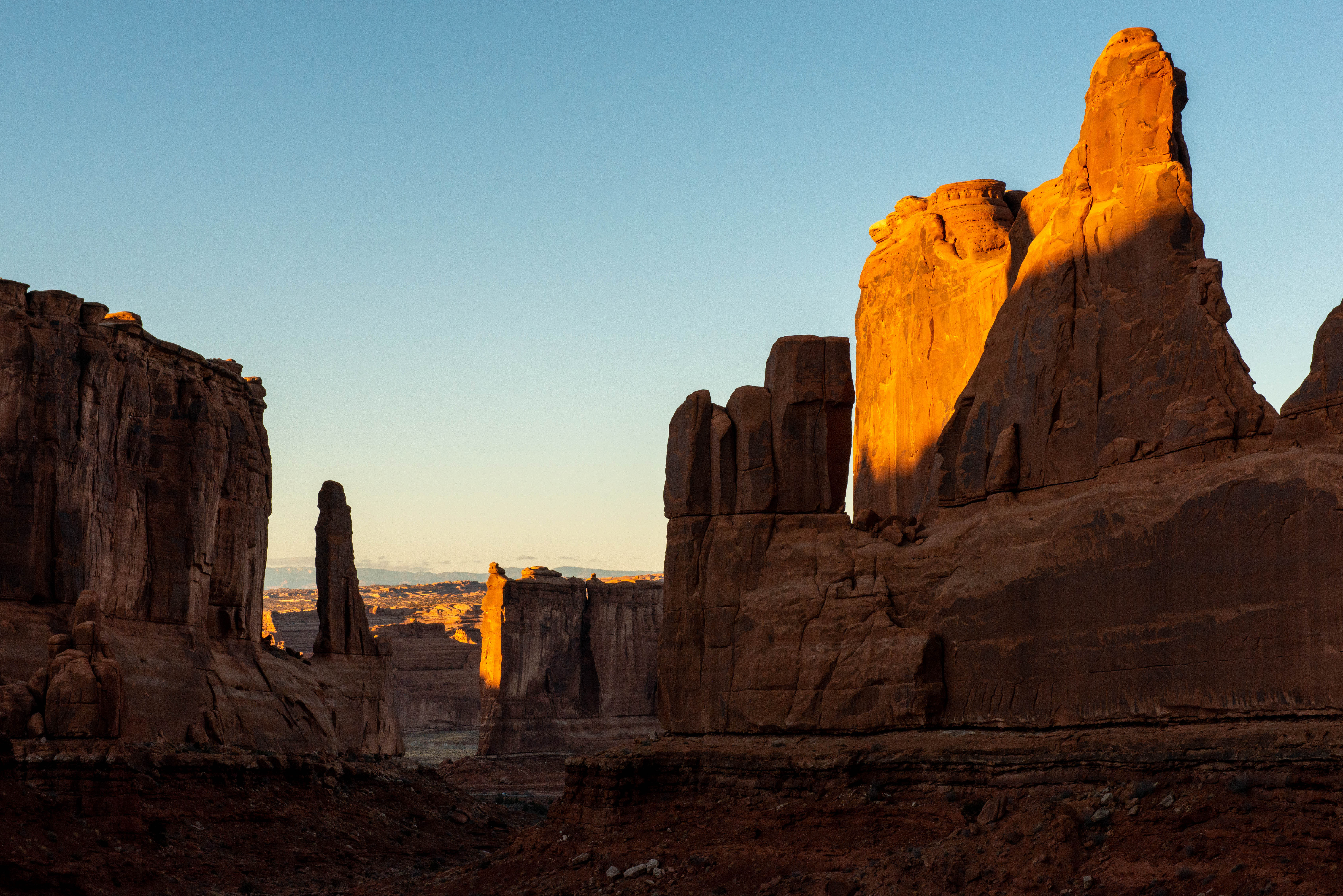
Park Features Overview. 172 words. 2 sections. This exhibit details “major points of interest” that are unique to Arches National Park. The panel titled Park Features begins with an overview that reads: In addition to numerous arches, the park contains an amazing array of balanced rocks, spires and pinnacles, whimsical formations and vast “petrified” dunes that will challenge your imagination and inspire further study. Some of the major points of interest include the following. Look around as you explore Arches National Park and find your own favorite spots. End of section. The panel lists 13 sites, each one numbered and including a brief description and a small photo. On the map on the right side of the panel, each site is located by its number, beginning with the nearest feature to the visitor center, which is noted as “You are here” at the southern end of the map. Also noted at the visitor center locale are restrooms and drinking water. To learn more about these sites, access the menu. End of description. Exterior Zone 2 Menu Park Features: Park Avenue, Courthouse Towers, Petrified Dunes, and The Great Wall. 407 words. Park Features: Balanced Rock, Windows Section, and Garden of Eden. 357 words. Park Features: Wolfe Ranch, Delicate Arch, and Fiery Furnace. 359 words. Park Features: Skyline, Devils Garden, and Klondike Bluffs. 348 words. Navigation to Exterior Zone 3, What to Do at Arches. 69 words. [2a] Park Features: Park Avenue, Courthouse Towers, Petrified Dunes, and The Great Wall Park Features: Park Avenue, Courthouse Towers, Petrified Dunes, and The Great Wall. 407 words. 5 sections. End of section. Feature 1 is Park Avenue. Text reads: Park Avenue features include a flat-walled canyon, with walls reminiscent of a big city skyline, several odd-shaped pinnacles and a great cross-section of the main sandstone layers. The photo depicts the described features with the orange walls and pinnacles sunlit under a blue sky. The location on the map indicates that Park Avenue Viewpoint and Trailhead is northeast of the visitor center, following the paved road. End of section. Feature 2 is Courthouse Towers. Text reads: The Courthouse Towers area contains many large monoliths, free standing rocks, remnants of a large, now-eroded mesa. The Tower of Babel, the Organ, Sheep Rock, and the Three Gossips are all visible from the main park road and from the Towers Viewpoint. The photo depicts the described features, a group of orange monoliths rising from the desert brush against a blue sky. The location on the map indicates that Courthouse Towers Viewpoint lies north of Park Avenue, following the paved road. The rock structures mentioned in the description surround the viewpoint. End of section. Feature 3 is Petrified Dunes. Text reads: The Petrified Dunes are not really petrified. The Navajo Sandstone was originally laid down in a vast dune field and solidified by the pressure of overlying rock layers and cementing agents precipitated out of ocean water. The area has eroded to look like dunes again. The photo depicts the described features with rounded orange and brown mounds of stone, interspersed by green brush. The location on the map indicates Petrified Dunes Viewpoint is northeast of Courthouse Towers, following the paved road. The Petrified Dunes occupy an expanse that stretches at least two miles east of the road. End of section. Feature 4 is The Great Wall. Text reads: The Great Wall stretches along the main road for several miles, marking the front line in the battle between the forces of erosion and the ancient sandstone. The photo depicts the described feature with a high continuous red sandstone canyon wall divided by a long horizonal shadow, and in the background, a dramatic sky of pink, white, and dark blue. The location on the map indicates The Great Wall is located to the west of the roadway, a short way north of Petrified Dunes Viewpoint, following the paved road. End of description. [2b] Park Features: Balanced Rock, Windows Section, and Garden of Eden Park Features: Balanced Rock, Windows Section, and Garden of Eden. 357 words. 4 sections. End of section. Feature 5 is Balanced Rock. Text reads: Balanced Rock shows the contrast between two layers of rock. The stronger layer forms the massive cap, while the lower layer show how easily some sandstone can be eroded. Take the easy walk close to its base to fully appreciate its size. The photo depicts a tapering red rock base with a tall oval rock seemingly balanced on top of the base. The location on the map indicates Balanced Rock can be reach by hiking to the east of the paved road, several miles north of The Great Wall. Also noted near the locale, to the east of the road, are restrooms and picnic areas. End of section. Feature 6 is Windows Section. Text reads: The Windows Section of the park contains some of the largest and most accessible arches. North and South Windows, together known as the Spectacles, are classic rounded arch shapes, and hikers can walk an easy one-half mile trail and stand in the opening of North Window. Turret Arch has two oddly shaped openings, and one of the openings in Double Arch is the third largest in the park. The photo depicts a red stone formation that features two arches framing a blue sky. The location on the map indicates Windows Section can be reached by turning east off the main road onto a spur road just past Balanced Rock and proceeding southward to a loop. From there, all the mentioned arches can be seen or hiked. Also noted at the locale are restrooms. End of section. Feature 7 is Garden of Eden. Text reads: The Garden of Eden contains a wonderful concentration of whimsical and intriguing pinnacles and walls. The photo depicts several red stone formations with rounded and bulbous forms, set against a cloud-filled sky. The location on the map indicates Garden of Eden can be reached by the same spur road that leads to Windows Section. The locale is on the east side of the road, north of Windows Section. End of description. [2c] Park Features: Wolfe Ranch, Delicate Arch, and Fiery Furnace Park Features: Wolfe Ranch, Delicate Arch, and Fiery Furnace. 359 words. 4 sections. End of section. Feature 8 is Wolfe Ranch. Text reads: Wolfe Ranch preserves an early 1900s attempt at settlement. John Wesley Wolfe and some of his family tried to eke out a living here for over ten years. Imagine trying to survive in this inhospitable location. The photo depicts a portion of an aged log cabin with a bleached clay roof. Against it is the ruin of an old wagon. The location on the map indicates Wolfe Ranch can be reached by returning to the main road, turning right to continue north, then taking the second right turn. This second spur road heads eastward. Also noted at the locale are restrooms. End of section. Feature 9 is Delicate Arch. Text reads: Delicate Arch is probably the most famous arch in the world. Not the longest, not the widest, and not the tallest, but undoubtedly the most photographed, standing on the edge of a smooth sandstone bowl with the dramatic La Sal Mountains in the background. The photo depicts a sweeping bowl of red and yellow striated sandstone from which rises a red rock arch with snow covered mountains in the deep background. The location on the map indicates Delicate Arch can be reached by hiking from Wolfe Ranch or can be viewed by driving east along the main road to Delicate Arch Viewpoint and hiking a short distance. Also noted at the Delicate Arch Viewpoint locale are restrooms. End of section. Feature 10 is Fiery Furnace. Text reads: Fiery Furnace's name belies its cool shady canyons beneath towering rock walls. Join a ranger for an exciting and moderately strenuous walk through this tangled maze, where there is no trail. The photo depicts a dense cluster of red rock pinnacles and stone canyon towers. In the deep background are dramatic snow-covered peaks. The location on the map indicates Fiery Furnace Viewpoint can be reached by returning to the main road, turning right to continue north, and heading to the second right. Also noted at the Fiery Furnace Viewpoint locale are restrooms. End of description. [2d] Park Features: Skyline, Devils Garden, and Klondike Bluffs Park Features: Skyline, Devils Garden, and Klondike Bluffs. 348 words. 4 sections. End of section. Feature 11 is Skyline Arch. Text reads: Skyline Arch is famous for dropping a large boulder in 1941 and doubling its size in a mere instant. Watch for it along the main park road. The photo depicts a red stone arch rising from steep canyon walls. The location on the map indicates Skyline Arch can be reached by continuing north on the main road from Fiery Furnace. End of section. Feature 12 is Devils Garden. Text reads: Devils Garden is 18 miles from the park entrance, features the campground, picnic areas, and the longest trail in the park. Landscape Arch stretches an improbable 306 feet or 93 meters. Walk the easy 0.8 mile or 1.3 km (one way) trail to see it. More than half a dozen other major arches may be seen from the hiking trail. The photo depicts a broad thin brownish-red arch crossing over a rocky, brushy landscape. The location indicates Devils Garden Trailhead is in the middle of a loop at the end of the main road. Numerous arches can be hiked to from that location. Also noted at the Devils Garden Trailhead and Campground locales are restrooms, drinking water, and picnic areas. End of section. Feature 13 is Klondike Bluffs. Text reads: Klondike Bluffs is a remote area, accessible only by an unpaved road down the bottom of Salt Valley. Tower Arch and the pinnacles of the Marching Men may be seen along the hiking trail. The photo depicts monumental canyon walls framing a stone arch amid fallen rock. The location indicates Klondike Bluffs can be reached by turning off the main road between the campground and Fiery Furnace onto an unpaved road that proceeds northwest through Salt Valley. Restroom at trailhead. End of section.
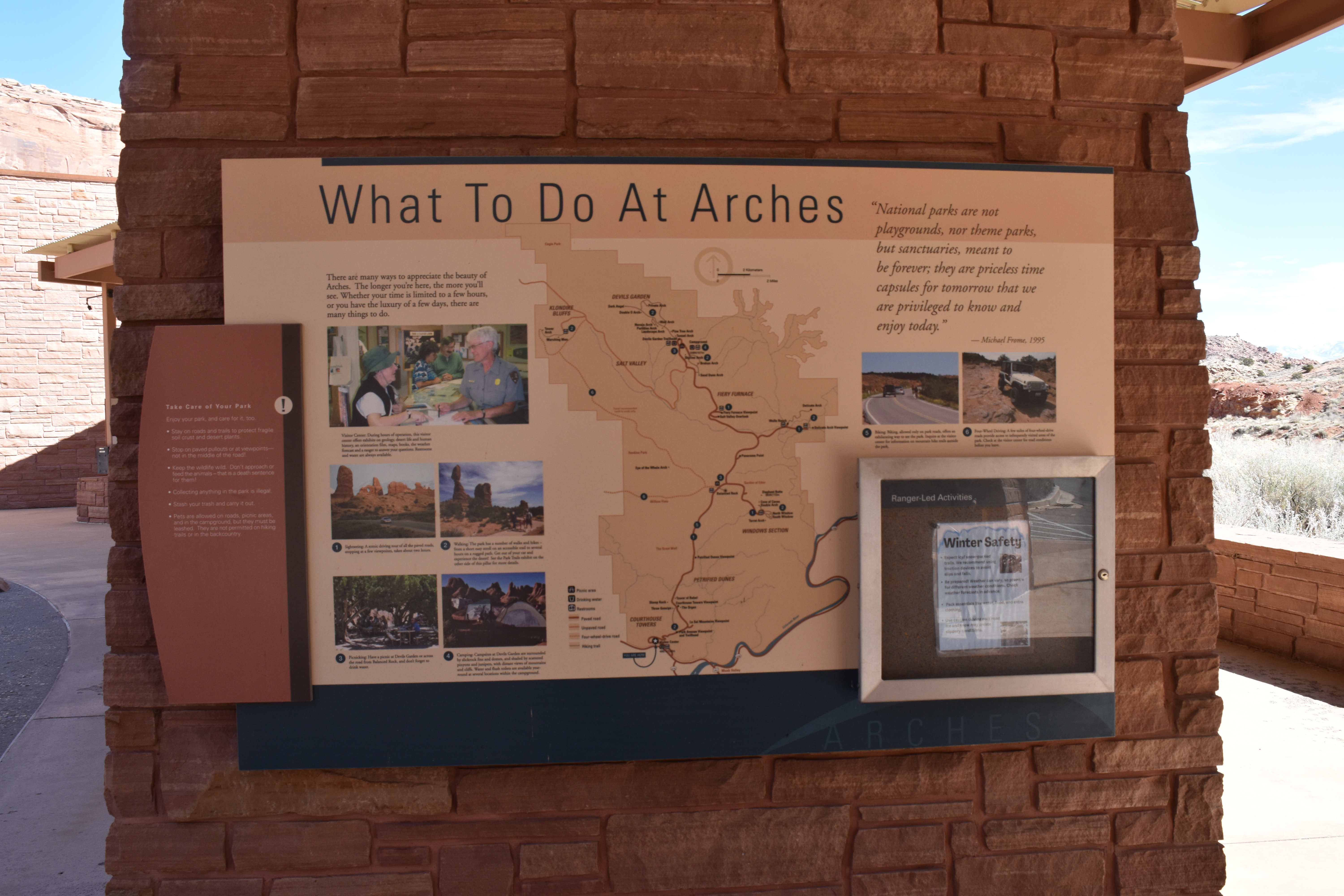
[Exterior Zone 3] What to Do at Arches What to Do at Arches Overview. 425 words. 3 sections. This panel, titled What to Do at Arches, identifies activities for enjoying the park and notes park locations for these activities on a large map. On the right is a quote attributed to Michael Frome in 1995. The quote reads: "National parks are not playgrounds, nor theme parks, but sanctuaries, meant to be forever; they are priceless time capsules for tomorrow that we are privileged to know and enjoy today." The main panel text reads: There are many ways to appreciate the beauty of Arches. The longer you're here, the more you'll see. Whether your time is limited to a few hours, or you have the luxury of a few days, there are many things to do. A color photo below the text shows a smiling ranger pointing out information on a document to a park guest. They are surrounded by displays and information in cases. Other guests occupy the background. The photo caption reads: Visitor Center. During hours of operation, this visitor center offers exhibits on geology, desert life and human history, an orientation film, maps, books, the weather forecast and a ranger to answer your questions. Restrooms and water are always available. End of section. Attached to the left side of the panel is a set of instructions, titled Take Care of Your Park! Text reads: Enjoy your park, and care for it, too. 1. Stay on roads and trails to protect fragile soil crust and desert plants. 2. Stop on paved pullouts or at viewpoints, not in the middle of the road! 3. Keep the wildlife wild. Don't approach or feed the animals. That is a death sentence for them! 4. Collecting anything in the park is illegal. 5. Stash your trash and carry it out. 6. Pets are allowed on roads, picnic areas, and in the campground, but they must be leashed. They are not permitted on hiking trails or in the backcountry. End of section. Next on the panel are six activities, each one numbered, explained, and accompanied by a color photo. They are sightseeing, walking, picnicking, camping, biking, and four-wheel driving. On the large park map in the center of the panel, the activity numbers are noted in specific locations, identifying ideal locales for carrying out the activity. These will all be described. A small bulletin case mounted at the bottom right of the panel displays information that changes seasonally and is not described here. To learn more about the activities at Arches, access the menu. End of description. Exterior Zone 3 Menu Sightseeing, Walking, and Picnicking. 283 words. Camping, Biking, and Four-wheel Driving. 267 words. Navigation to Exterior Zone 4, Park Trails. 41 words. [3a] Sightseeing, Walking, and Picnicking Sightseeing, Walking, and Picnicking. 283 words. 4 sections. End of section. Activity 1 is Sightseeing. Photo shows a car driving down a two-laned paved road through the park. Stone pinnacles and a stone arch occupy the near background, with snowy mountains in the far background. Text reads: A scenic driving tour of all the paved roads, stopping at a few viewpoints, takes about two hours. Map locations include the main road from the Visitor Center through Petrified Dunes, the loop at Windows Section, continuing north and east to Delicate Arch Viewpoint, and then further north to Fiery Furnace Viewpoint. End of section. Activity 2 is Walking. Photo shows a family of four walking down a well-maintained path that leads to Balanced Rock in the background. Text reads: The park has a number of walks and hikes, from a short easy stroll on an accessible trail to several hours on a rugged path. Get out of your car and experience the desert! See the Park Trails exhibit on the other side of this pillar for more details. Map locations include the hiking trail that connects Park Avenue Viewpoint and Trailhead to Courthouse Towers Viewpoint; the trails at North and South Windows; the trail that leads from Delicate Arch Viewpoint; trails to Skyline, Broken, and Sand Dune Arches; the trails leading north from Devils Garden Trailhead; and the trails in Klondike Bluffs. End of section. Activity 3 is Picnicking. Photo shows three picnic tables occupied by guests in a shady location. Text reads: Have a picnic at Devils Garden or across the road from Balanced Rock, and don't forget to drink water. Map locations include Balanced Rock and the Devils Garden Trailhead. End of description. [3b] Camping, Biking, and Four-wheel Driving Camping, Biking, and Four-wheel Driving. 267 words. 4 sections. End of section. Activity 4 is Camping. Photo shows tents, campers, and camping vehicles, all surrounded by stone formations in a canyon as evening falls. Text reads: Campsites at Devils Garden are surrounded by slickrock fins and domes, and shaded by scattered pinyons and junipers, with distant views of mountains and cliffs. Water and flush toilets are available ear-round at several locations within the campground. The map location is near Devils Garden Trailhead. End of section. Activity 5 is Biking. Photo shows bicyclists riding along a curving two-lane park road. They are being passed by two vehicles, one of which is carrying bicycles on a roof rack. Text reads: Biking, allowed only on park roads, offers an exhilarating way to see the park. Inquire at the visitor center for information on mountain bike trails outside the park. The map location is the main paved road running through the park. End of section. Activity 6 is Four-Wheel Driving. Photo shows a white jeep moving down a rocky stone and sand path. In the background, a second jeep is rounding a tree. Text reads: A few miles of four-wheel-drive roads provide access to infrequently visited areas of the park. Check at the visitor center for road conditions before you leave. Map locations are specified as four-wheel-drive roads on the west side of the park, starting from the main road near Balanced Rock, through Willow Flats or descending from Klondike Bluffs on the west side of Salt Valley. A map note reads: trail recommended north to south only. End of description. [3c] Navigation to Exterior Zone 4, Park Trails. Navigation to Exterior Zone 4, Park Trails. 41 words. From the What to Do at Arches exhibit, move around the partition to its opposite side. You will encounter the Park Trails exhibit on this side of the partition. End of description.
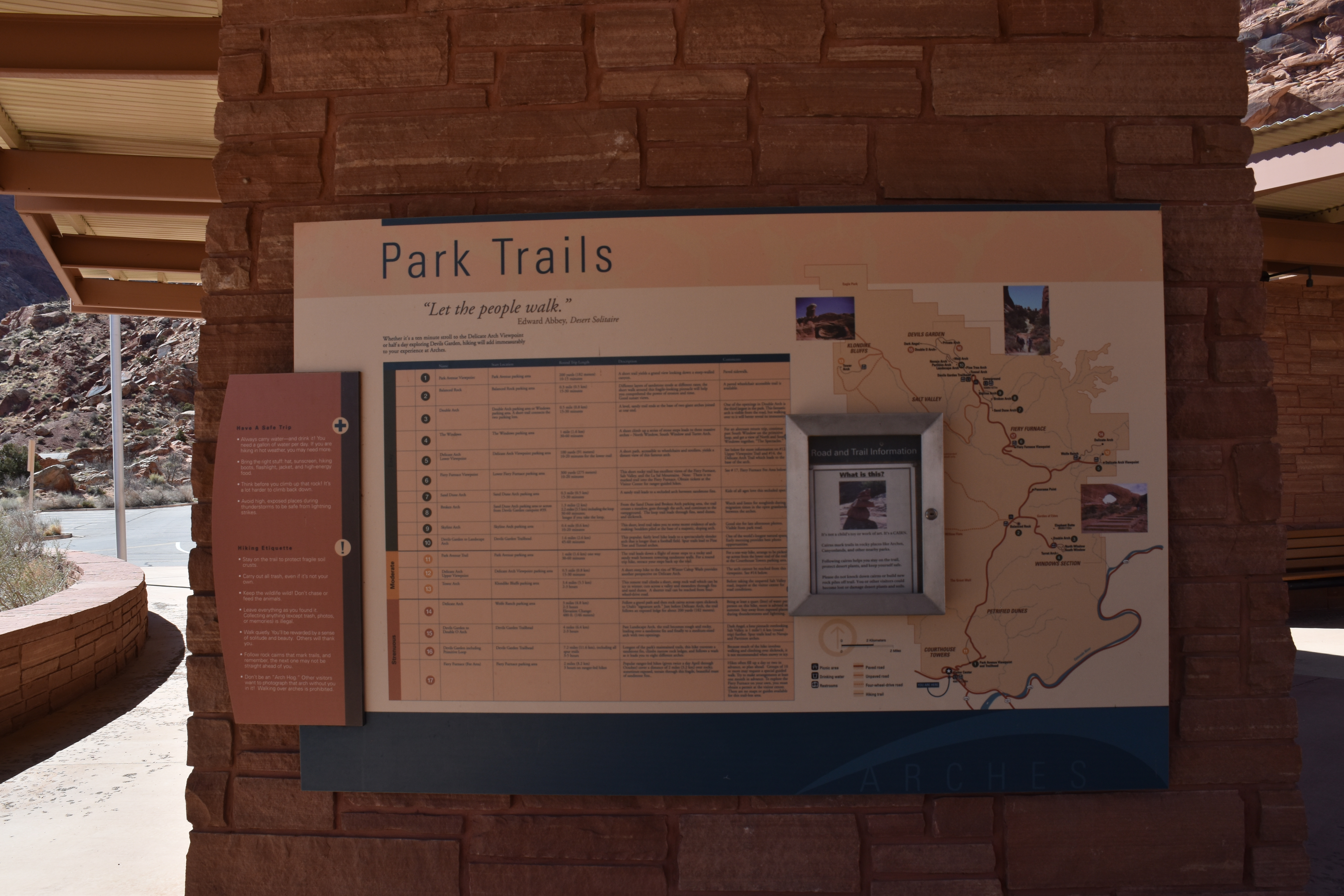
[Exterior Zone 4] Park Trails Park Trails Overview. 405 words. 4 sections. This panel, titled Park Trails, identifies hiking trails throughout the park, providing important data to know before hiking, and notes trail locations on a large map. Below the title is a quote attributed to Edward Abbey in Desert Solitaire. The quote reads: "Let the people walk." Introductory panel text reads: Whether it's a ten-minute stroll to the Delicate Arch Viewpoint or half a day exploring Devils Garden, hiking will add immeasurably to your experience at Arches. End of section. Attached to the left side of the panel is a set of instructions. The first section, titled Have a Safe Trip, is emphasized with a graphic plus-sign. Text reads: 1. Always carry water and drink it! You need a gallon of water per day. If you are hiking in hot weather, you may need more. 2. Bring the right stuff: hat, sunscreen, hiking boots, flashlight, jacket, and high-energy food. 3. Think before you climb up that rock! It's a lot harder to climb back down. 4. Avoid high, exposed places during thunderstorms to be safe from lightning strikes. End of section. The second section of the instructions, titled Hiking Etiquette, is emphasized with a graphic exclamation mark. Text reads: 1. Stay on the trail to protect fragile soil crusts. 2. Carry out all trash, even if it's not your own. 3. Keep the wildlife wild! Don't chase or feed the animals. 4. Leave everything as you found it. Collecting anything, except trash, photos, or memories, is illegal. 5. Walk quietly. You'll be rewarded by a sense of solitude and beauty. Others will thank you. 6. Follow rock cairns that mark trails, and remember, the next one may not be straight ahead of you. 7. Don't be an "Arch Hog." Other visitors want to photograph that arch without you in it! Walking over arches is prohibited. End of section. On a large chart, the park’s hiking trails are grouped by difficulty and noted individually by number. Details are added that identify each trail’s name, start location, round trip length, description, and comments. The location of the trail is noted on the large map on the right of the panel. A small bulletin case mounted at the center right of the panel displays road and trail information that changes seasonally and is not described here. To learn about the park’s hiking trails in more detail, access the menu. End of description. Exterior Zone 4 Menu Easy Trails, Part 1: Park Avenue, Balanced Rock, Windows Area, Delicate Arch Lower Viewpoint. 432 words. Easy Trails, Part 2: Fiery Furnace Viewpoint, Sand Dune Arch, Broken Arch, Skyline Arch, Devils Garden to Landscape Arch. 446 words. Moderate Trails. 276 words. Strenuous Trails. 445 words. Navigation to Exterior Zone 5, Canyon Country. 40 words. [4a] Easy Trails, Part 1: Park Avenue, Balanced Rock, Windows Area, Delicate Arch Lower Viewpoint Easy Trails, Part 1: Park Avenue, Balanced Rock, Windows Area, Delicate Arch Lower Viewpoint. 432 words. 6 sections. These trails, as well as the ones noted on the next track, are easy in difficulty. End of section. Number 1 is Park Avenue Viewpoint, which starts at Park Avenue parking area. Its round-trip length is 200 yards or 182 meters, and it will take approximately 10 to 15 minutes. Its description reads: A short trail yields a grand view looking down a steep-walled canyon. Comments read: paved sidewalk. End of section. Number 2 is Balanced Rock, which starts at Balanced Rock parking area. Its round-trip length is 0.3 mile or 0.5 kilometer, and it will take approximately 15 to 30 minutes. Its description reads: Different layers of sandstone erode at different rates; the short walk around this fragile-looking pinnacle will help you comprehend the power of erosion and time. Good sunset views. Comments read: A paved wheelchair accessible trail is available. End of section. Number 3 is Double Arch, which starts at Double Arch parking area or Windows parking area. A short trail connects the two parking lots. Its round-trip length is 0.5 mile or 0.8 kilometer, and it will take approximately 15 to 30 minutes. Its description reads: A level, sandy trail ends at the base of two giant arches joined at one end. Comments read: One of the openings in Double Arch is the third largest in the park. This arch is visible from the road, but walking over to it will better reveal its immensity. End of section. Number 4 is The Windows, which starts at The Windows parking area. Its round-trip length is 1 mile or 1.6 kilometer, and it will take approximately 30 to 60 minutes. Its description reads: A short climb up a series of stone steps leads to three massive arches, North Window, South Window and Turret Arch. Comments read: For an alternate return trip, continue past South Window on the primitive loop, and get a view of North and South Windows together, "The Spectacles." End of section. Number 5 is Delicate Arch Lower Viewpoint, which starts at Delicate Arch Viewpoint parking area. Its round-trip length is 100 yards or 91 meters, and it will take approximately 10 to 20 minutes for the lower trail. Its description reads: A short path, accessible to wheelchairs and strollers, yields a distant view of this famous arch. Comments read: See below for more information on number 12, Upper Viewpoint Trail and number 14, the Delicate Arch Trail which leads to the base of the arch. End of description. [4b] Easy Trails, Part 2: Fiery Furnace Viewpoint, Sand Dune Arch, Broken Arch, Skyline Arch, Devils Garden to Landscape Arch Easy Trails, Part 2: Fiery Furnace Viewpoint, Sand Dune Arch, Broken Arch, Skyline Arch, Devils Garden to Landscape Arch. 446 words. 6 sections. These trails, as well as the ones noted on the last track, are easy in difficulty. End of section. Number 6 is Fiery Furnace Viewpoint, which starts at Lower Fiery Furnace parking area. Its round-trip length is 300 yards or 275 meters, and it will take approximately 10 to 20 minutes. Its description reads: This short rocky trail has excellent views of the Fiery Furnace, Salt Valley, and the La Sal Mountains. Note: There is no marked trail into the Fiery Furnace. Obtain tickets at the Visitor Center for ranger-guided hikes. Comments read: See number 17, Fiery Furnace Fee Area below. End of section. Number 7 is Sand Dune Arch, which starts at Sand Dune Arch parking area. Its round-trip length is 0.3 mile or 0.5 kilometer, and it will take approximately 15 to 30 minutes. Its description reads: A sandy trail leads to a secluded arch between sandstone fins. Comments read: Kids of all ages love this secluded spot. End of section. Number 8 is Broken Arch, which starts at Sand Dune Arch parking area or across from Devils Garden campsite number 39. Its round-trip length is 1.3 miles or 2 kilometers. Including the loop, it is 2.2 miles or 3.5 kilometers. It will take approximately 30 to 60 minutes; longer if you take the loop. Its description reads: From the Sand Dune and Broken Arch parking area, the trail crosses a meadow, goes through the arch, and continues to the campground. The loop trail leads through fins, sand dunes, and slickrock. Comments read: Watch and listen for songbirds during migration times in the open grasslands between the arches. End of section. Number 9 is Skyline Arch, which starts at Skyline Arch parking area. Its round-trip length is 0.4 mile or 0.6 kilometer, and it will take approximately 10 to 20 minutes. Its description reads: This short, level trail takes you to some recent evidence of arch-making: boulders piled at the base of an arch. Comments read: Good site for late afternoon photos. Visible from park road. End of section. Number 10 is Devils Garden to Landscape Arch, which starts at Devils Garden Trailhead. Its round-trip length is 1.6 miles or 2.6 kilometers, and it will take approximately 45 to 60 minutes. Its description reads: This popular, fairly level hike leads to a slender arch that is longer than a football field. Spur trails lead to Pine Tree and Tunnel arches. Comments read: One of the world's longest natural spans. Early morning provides photo opportunities. End of description. [4c] Moderate Trails Moderate Trails. 276 words. 4 sections. The next three trails, numbers 11 through 13, are noted as moderate in difficulty. End of section. Number 11 is Park Avenue Trail, which starts at Park Avenue parking area. Its round-trip length is 1 mile or 1.6 kilometers one way, and it will take approximately 30 to 60 minutes. Its description reads: The trail leads down a flight of stone steps to a rocky and sandy wash between towering sandstone walls. For a round trip hike, retrace your steps back up the trail. Comments read: For a one-way hike, arrange to be picked up across from the lower end of the trail at the Courthouse Towers parking area. End of section. Number 12 is Delicate Arch Upper Viewpoint, which starts at Delicate Arch Viewpoint parking area. Its round-trip length is 0.5 mile or 0.8 kilometer, and it will take approximately 15 to 30 minutes. Its description reads: A short steep hike to the rim of Winter Camp Wash provides another perspective on Delicate Arch. Comments read: The arch cannot be reached from this viewpoint. See number 14 below. End of section. Number 13 is Tower Arch, which starts at Klondike Bluffs parking area. Its round-trip length is 3.4 miles or 5.5 kilometers, and it will take approximately 2 to 3 hours. Its description reads: This remote trail climbs a short, steep rock wall which can be icy in winter; cuts across a valley and meanders through fins and sand dunes. A shorter trail can be reached from four-wheel-drive road. Comments read: Before taking the unpaved Salt Valley Road, inquire at the visitor center for road conditions. End of description. [4d] Strenuous Trails Strenuous Trails. 445 words. 5 sections. The next four trails, numbers 14 through 17, are noted as strenuous in difficulty. End of section. Number 14 is
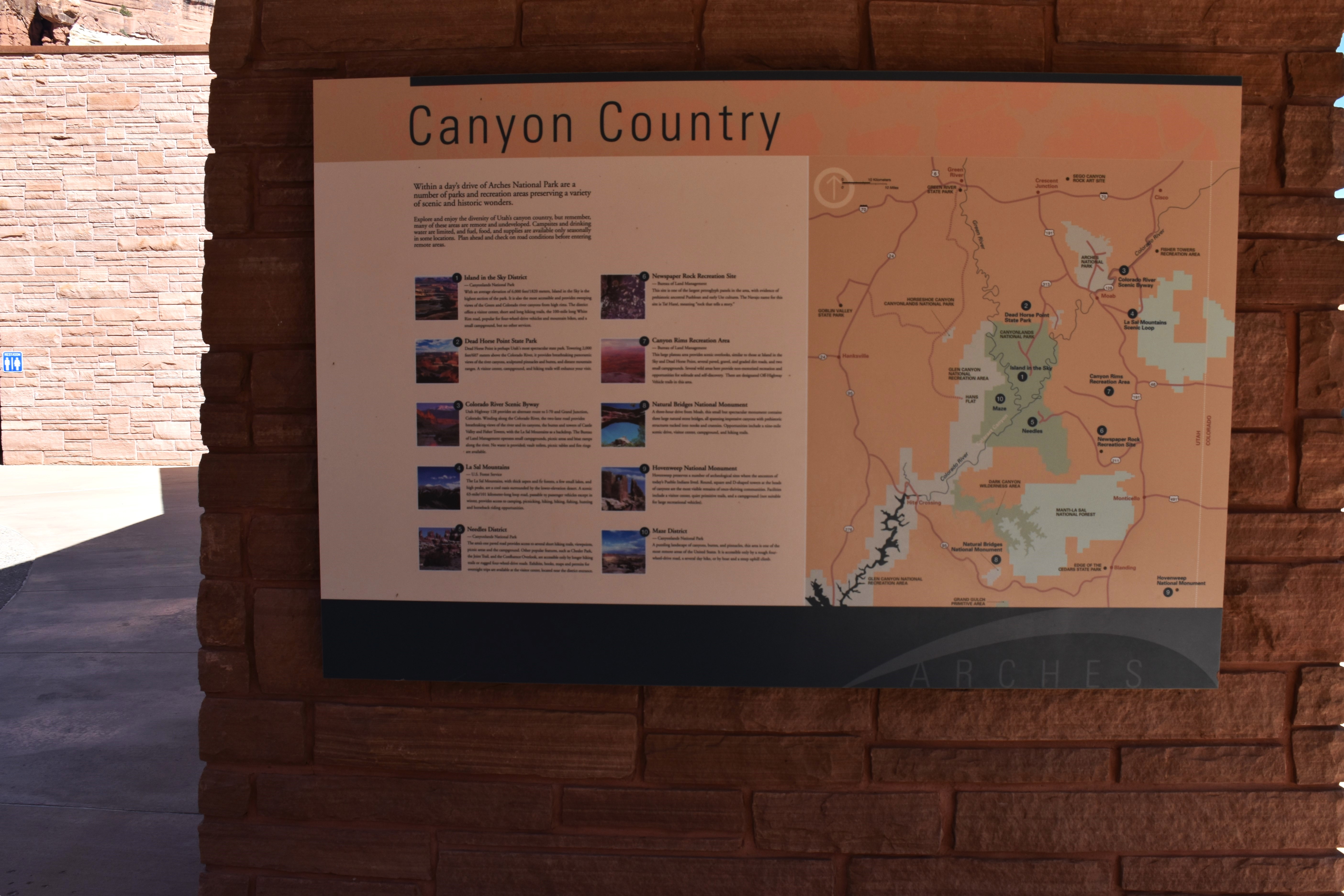
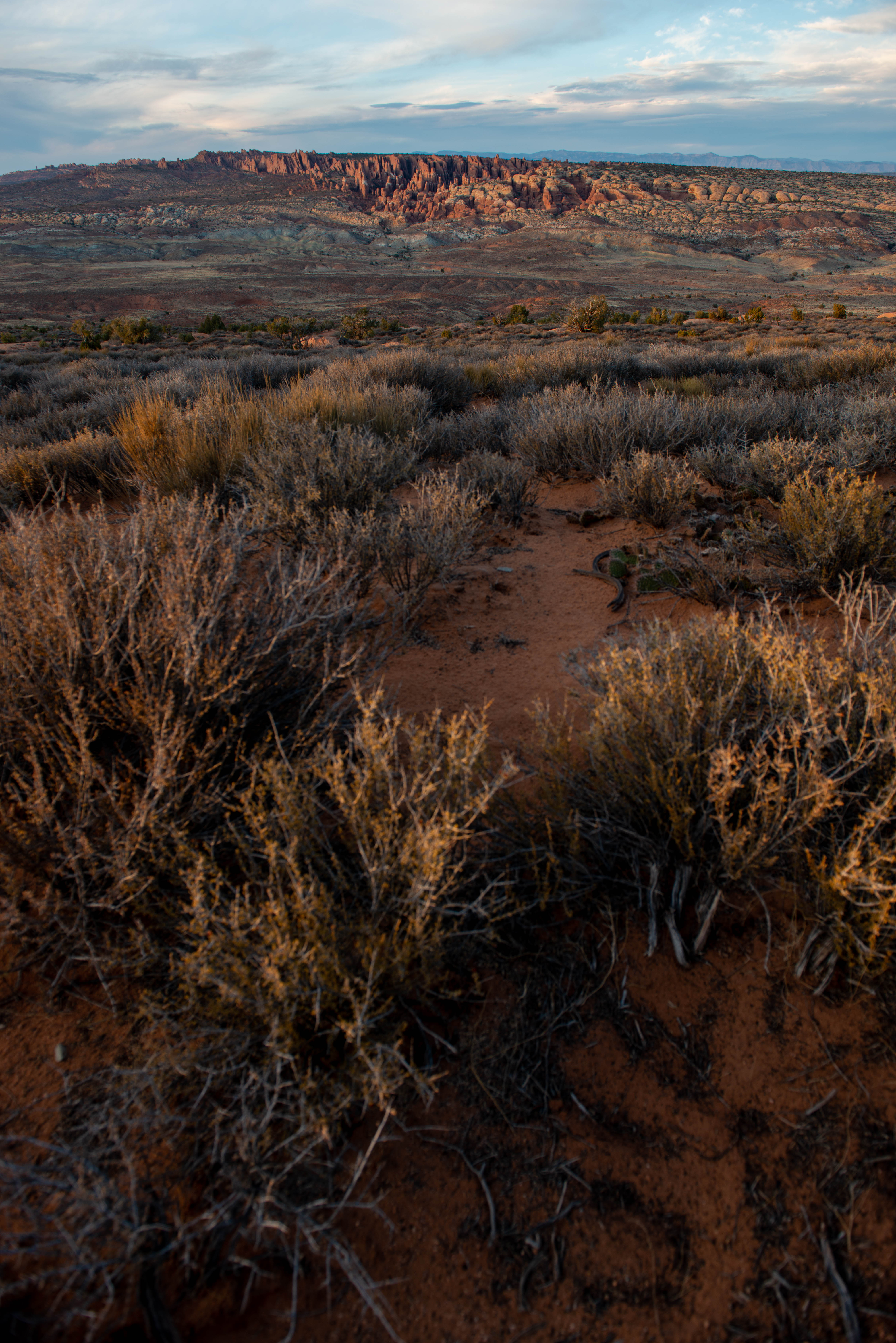
[Exterior Zone 5] Canyon Country Canyon Country Overview. 229 words. 3 sections. This panel, titled Canyon Country, identifies and describes areas within the greater Utah region that provide more opportunities to experience canyons. A map notes their locations. The introductory text reads: Within a day's drive of Arches National Park are a number of parks and recreation areas preserving a variety of scenic and historic wonders. Explore and enjoy the diversity of Utah's canyon country, but remember, many of these areas are remote and undeveloped. Campsites and drinking water are limited, and fuel, food, and supplies are available only seasonally in some locations. Plan ahead and check on road conditions before entering remote areas. End of section. The map on the right side of the panel features the Utah region that extends beyond Arches National Park, including Canyonlands National Park, southwest of Arches following the Colorado River. Glen Canyon National Recreation Area is west of Canyonlands and continues southwest, still following the Colorado River. East of Glen Canyon National Recreation Area is Dark Canyon Wilderness Area and continuing eastward is Manti-La Sal National Forest. End of section. The left side of the panel lists ten specific areas, each one numbered and including a brief description and a small photo. On the map, each site is located by its number. By accessing the menu, you can learn more about Canyon Country areas. End of description. Exterior Zone 5 Menu Canyon Country areas closest to Arches: Island in the Sky, Dead Horse Point, Colorado River Scenic Byway, Las Sal Mountains. 477 words. Canyon Country areas moderately distanced from Arches, off Utah Highway 191: Needles, Newspaper Rock, and Canyon Rims. 343 words. Canyon Country areas farthest from Arches: Natural Bridges, Hovenweep, and Maze. 308 words. Navigation to Exterior Zone 6, Colorado Plateau Attractions. 41 words. [5a] Canyon Country areas closest to Arches: Island in the Sky, Dead Horse Point, Colorado River Scenic Byway, Las Sal Mountains Canyon Country areas closest to Arches: Island in the Sky, Dead Horse Point, Colorado River Scenic Byway, Las Sal Mountains. 477 words. 5 sections. End of section. Area 1 is Island in the Sky District at Canyonlands National Park. Accompanying text reads: With an average elevation of 6,000 feet or 1820 meters, Island in the Sky is the highest section of the park. It is also the most accessible and provides sweeping views of the Green and Colorado river canyons from high rims. The district offers a visitor center, short and long hiking trails, the 100-mile long White Rim road, popular for four-wheel-drive vehicles and mountain bikes, and a small campground, but no other services. The photo depicts a birds-eye view of a tight cluster of mesas separated by steep canyons. The location on the map indicates it lies near where the Green River meets the Colorado River, in the center of Canyonlands National Park. End of section. Area 2 is Dead Horse Point State Park. Accompanying text reads: Dead Horse Point is perhaps Utah's most spectacular state park. Towering 2,000 feet or 607 meters above the Colorado River, it provides breathtaking panoramic views of the river canyons, sculptured pinnacles and buttes, and distant mountain ranges. A visitor center, campground, and hiking trails will enhance your visit. The photo depicts a vista of sweeping canyons under a blue sky. The location on the map indicates Dead Horse Point is southwest of Arches on the way to Canyonlands National Park along highway 313. End of section. Area 3 is Colorado River Scenic Byway. Accompanying text reads: Utah Highway 128 provides an alternate route to I-70 and Grand Junction, Colorado. Winding along the Colorado River, the two-lane road provides breathtaking views of the river and its canyons, the buttes and towers of Castle Valley and Fisher Towers, with the La Sal Mountains as a backdrop. The Bureau of Land Management operates small campgrounds, picnic areas and boat ramps along the river. No water is provided; vault toilets, picnic tables and fire rings are available. The photo depicts a calm, curving waterway lined by red rock canyons and pinnacles, with snow-covered mountains in the background. The location on the map indicates Colorado River Scenic Byway is east of Arches along 128. End of section. Area 4 is La Sal Mountains, part of the U.S. Forest Service. Accompanying text reads: The La Sal Mountains, with thick aspen and fir forests, a few small lakes, and high peaks, are a cool oasis surrounded by the lower-elevation desert. A scenic 63-mile or 101 kilometer-long loop road, passable to passenger vehicles except in winter, provides access to camping, picnicking, hiking, biking, fishing, hunting and horseback riding opportunities. The photo depicts a range of gray mountain peaks. The location on the map indicates La Sal Mountains Scenic Loop is southeast of Arches. End of description. [5b] Canyon Country areas moderately distanced from Arches, off highway 191: Needles, Newspaper Rock, and Canyon Rims Canyon Country areas moderately distanced from Arches, off highway 191: Needles, Newspaper Rock, and Canyon Rims. 343 words. 4 sections. End of section. Area 5 is Needles District at Canyonlands National Park. Accompanying text reads: The area's one paved road provides access to several short hiking trails, viewpoints, picnic areas and the campground. Other popular features, such as Chesler Park, the Joint Trail, and the Confluence Overlook, are accessible only by longer hiking trails or rugged four-wheel-drive roads. Exhibits, books, maps and permits for overnight trips are available at the visitor center, located near the district entrance. The photo depicts a short foreground shrub backed by rounded boulders and pointed rock pinnacles, all featuring red, brown, and beige layers in strong contrast. The location on the map indicates Needles is in the southern portion of Canyonlands, southeast of the Colorado River. End of section. Area 6 is Newspaper Rock Recreation Site, Bureau of Land Management. Accompanying text reads: This site is one of the largest petroglyph panels in the area, with evidence of prehistoric ancestral Puebloan and early Ute cultures. The Navajo name for this site is Ise Hane meaning "rock that tells a story.” The photo depicts a section of gray rock face boldly carved with dozens of petroglyphs illustrating animals, humans, and symbols. The location on the map indicates Newspaper Rock Recreation Site is east of Canyonlands, from Needles on 211. End of section. Area 7 is Canyon Rims Recreation Area, Bureau of Land Management. Accompanying text reads: This large plateau area provides scenic overlooks, similar to those at Island in the Sky and Dead Horse Point, several paved, gravel, and graded dirt roads, and two small campgrounds. Several wild areas here provide non-motorized recreation and opportunities for solitude and self-discovery. There are designated Off-Highway Vehicle trails in this area. The photo depicts a vast vista of layered orange canyons stretching back to high pink walls. The location on the map indicates Canyon Rims Recreation Area is east of Canyonlands and north of Newspaper Rock on 191. End of description. [5c] Canyon Country areas farthest from Arches: Natural Bridges, Hovenweep, and Maze Canyon Country areas farthest from Arches: Natural Bridges, Hovenweep, and Maze. 308 words. 4 sections. End of section. Area 8 is Natural Bridges National Monument. Accompanying text reads: A three-hour drive from Moab, this small but spectacular monument contains three large natural stone bridges, all spanning impressive canyons with prehistoric structures tucked into nooks and crannies. Opportunities include a nine-mile scenic drive, visitor center, campground, and hiking trails. The photo depicts a narrow natural stone bridge overhead, framing a large stone in the background. The location on the map indicates Natural Bridges National Monument is south of Canyonlands and west of Blanding, Utah, reachable by Highway 95. End of section. Area 9 is Hovenweep National Monument. Accompanying text reads: Hovenweep preserves a number of archeological sites where the ancestors of today's Pueblo Indians lived. Round, square and D-shaped towers at the heads of canyons are the most visible remains of once-thriving communities. Facilities include a visitor center, quiet primitive trails, and a campground (not suitable for large recreational vehicles). The photo depicts remnants of red stone ancient towers rising out of canyon walls among massive natural gray stone. The location on the map indicates Hovenweep Nation Monument is east of Blanding, Utah, near the border of Colorado. End of section. Area 10 is Maze District at Canyonlands National Park. Accompanying text reads: A puzzling landscape of canyons, buttes, and pinnacles, this area is one of the most remote areas of the United States. It is accessible only by a rough four-wheel-drive road, a several day hike, or by boat and a steep uphill climb. The photo depicts layers of canyons and buttes of varying colors, reds, yellows, whites, and deep grays. The location on the map indicates Maze District is in the southwestern portion of Canyonlands, west of where the Green and Colorado Rivers meet. End of description. [5d] Navigation to Exterior Zone 6, Colorado Plateau Attractions Navigation to Exterior Zone 6, Colorado Plateau Attractions. 41 words. From the Canyon Country exhibit, move back to the walkway and around the current partition to its opposite side, where you will encounter the Colorado Plateau Attractions exhibit. End of description.
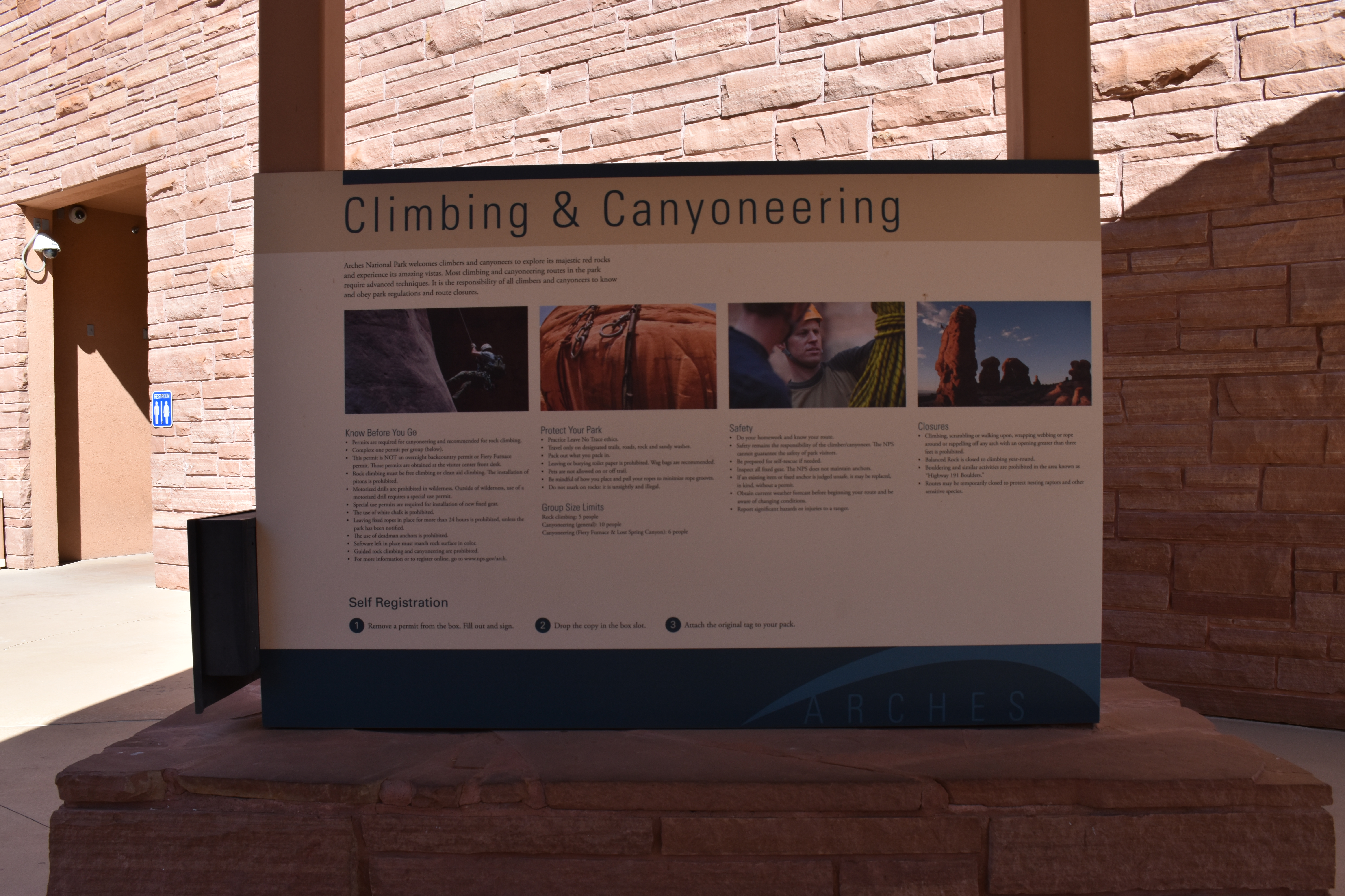
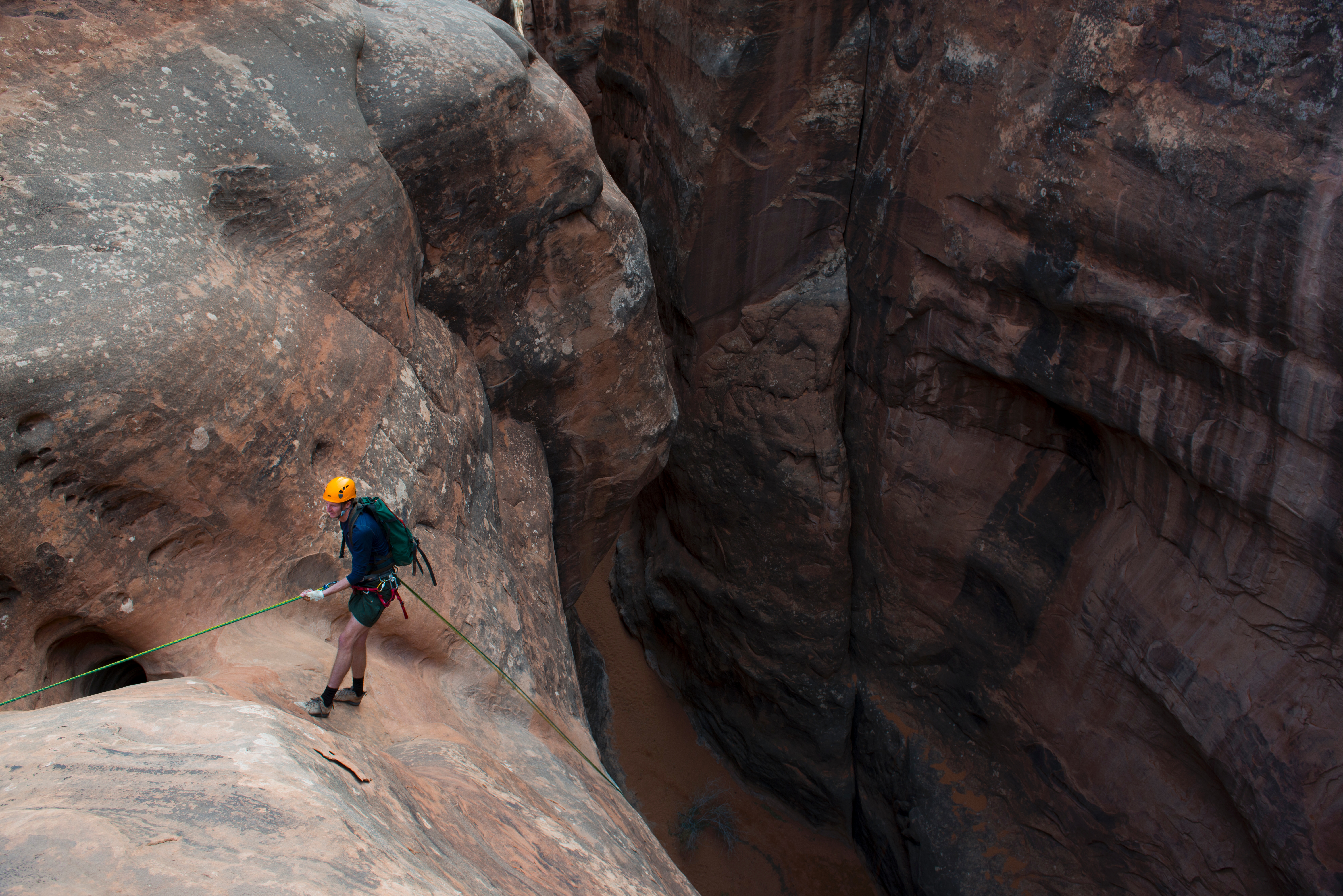
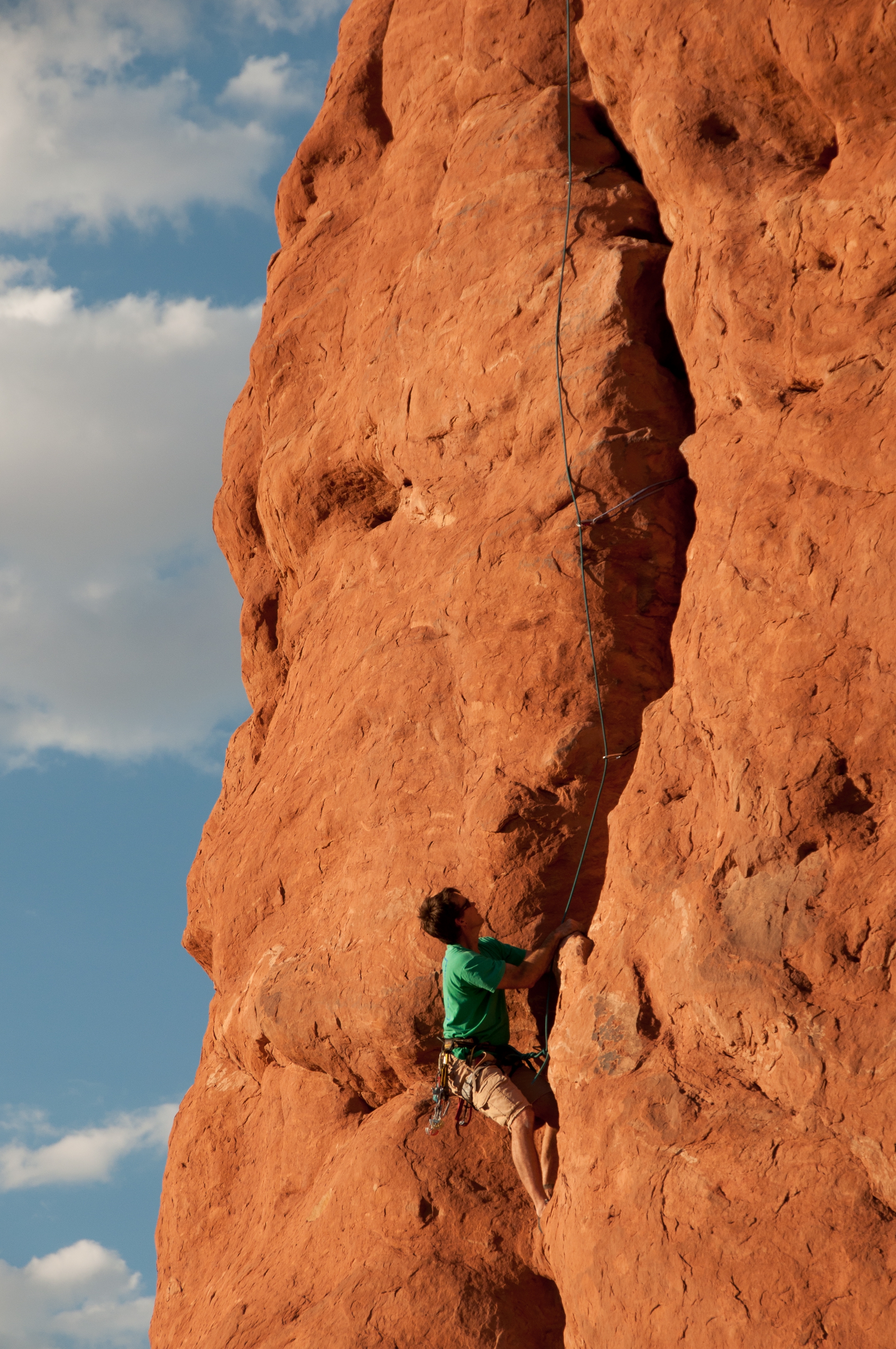
Climbing and Canyoneering Overview. 197 words. 4 sections. This panel informs visitors of the rules and safety practices for climbing and canyoneering in the park, as well as instructs how to obtain a permit for these activities. End of section. The introductory text on the panel reads: Arches National Park welcomes climbers and canyoneers to explore its majestic red rocks and experience its amazing vistas. Most climbing and canyoneering routes in the park require advanced techniques. It is the responsibility of all climbers and canyoneers to know and obey park regulations and route closures. End of section. Below the text are four large color images, each one placed above one of the following topics: Know Before You Go, Protect Your Park, Safety, and Closures. To learn more about these topics, access the menu. End of section. On the left side of the partition, separate from the panel, is a black metal box that contains the documents to complete for a Permit Self Registration. The panel provides instructions: 1. Remove a permit from the box. Fill out and sign. 2. Drop the copy in the box slot. 3. Attach the original tag to your pack. End of description. Exterior Zone 7 Menu Know Before You Go and Protect Your Park. 353 words. Safety and Closures. 235 words. Navigation to Exterior Zone 8, Cycling. 44 words. [7a] Know Before You Go and Protect Your Park Know Before You Go and Protect Your Park. 353 words. 3 sections. The first photo depicts a section of vertical, gray rock face and a rock climber in full gear, including helmet and gloves, attached to a rope. The section is titled, Know Before You Go. The information listed below is as follows: 1. Permits are required for canyoneering and recommended for rock climbing. 2. Complete one permit per group. See the box below. 3. This permit is NOT an overnight backcountry permit or Fiery Furnace permit. Those permits are obtained at the visitor center front desk. 4. Rock climbing must be free climbing or clean aid climbing. The installation of pitons is prohibited. 5. Motorized drills are prohibited in wilderness. Outside of wilderness, use of a motorized drill requires a special use permit. 6. Special use permits are required for installation of new fixed gear. 7. The use of white chalk is prohibited. 8. Leaving fixed ropes in place for more than 24 hours is prohibited, unless the park has been notified. 9. The use of deadman anchors is prohibited. 10. Software let in place must match rock surface in color. 11. Guided rock climbing and canyoneering are prohibited. 12. For more information or to register online, go to www.nps.gov slash arch. End of section. The second photo depicts nylon climbing ropes and hardware against a background of red sandstone that bears deep vertical grooves. The section is titled Protect Your Park. The information listed below reads: 1. Practice Leave No Trace ethics. 2. Travel only on designated trails, roads, rock and sandy washes. 3. Pack out what you pack in. 4. Leaving or burying toilet paper is prohibited. Wag bags are recommended. 5. Pets are not allowed on or off trail. 6. Be mindful of how you place and pull your ropes to minimize rope grooves. 7. Do not mark on rocks: it is unsightly and illegal. End of section. Group Size Limits are defined as follows: For Rock climbing: 5 people. For general Canyoneering: 10 people. For Canyoneering at Fiery Furnace and Lost Spring Canyon: 6 people. End of description. [7b] Safety and Closures Safety and Closures. 235 words. 2 sections. The third photo depicts two climbers, both wearing helmets, inspecting a large bundle of rope. The section is titled Safety. The information listed below is as follows: 1. Do your homework and know your route. 2. Safety remains the responsibility of the climber or canyoneer. The NPS cannot guarantee the safety of park visitors. 3. Be prepared for self-rescue if needed. 4. Inspect all fixed gear. The NPS does not maintain anchors. 5. If an existing item or fixed anchor is judged unsafe, it may be replaced in kind, without a permit. 6. Obtain current weather forecast before beginning your route and be aware of changing conditions. 7. Report significant hazards or injuries to a ranger. End of section. The fourth photo depicts a cluster of monolithic red sandstone pinnacles. Sunlight illuminates the left side of the one in the foreground, revealing a climber in silhouette, about two-thirds up the face. The section is titled Closures. The information listed below is as follow: 1. Climbing, scrambling or walking upon, wrapping webbing or rope around or rappelling off any arch with an opening greater than three feet is prohibited. 2. Balanced Rock is closed to climbing year-round. 3. Bouldering and similar activities are prohibited in the area known as "Highway 191 Boulders." 4. Routes may be temporarily closed to protect nesting raptors and other sensitive species. End of description. [7c] Navigation to Exterior Zone 8, Cycling Navigation to Exterior Zone 8, Cycling. 44 words. From the Climbing and Canyoneering exhibit move to your right around the knee-wall. After you pass the knee-wall, turn right and move forward about 8 feet to reach the panel on your right. End of description.
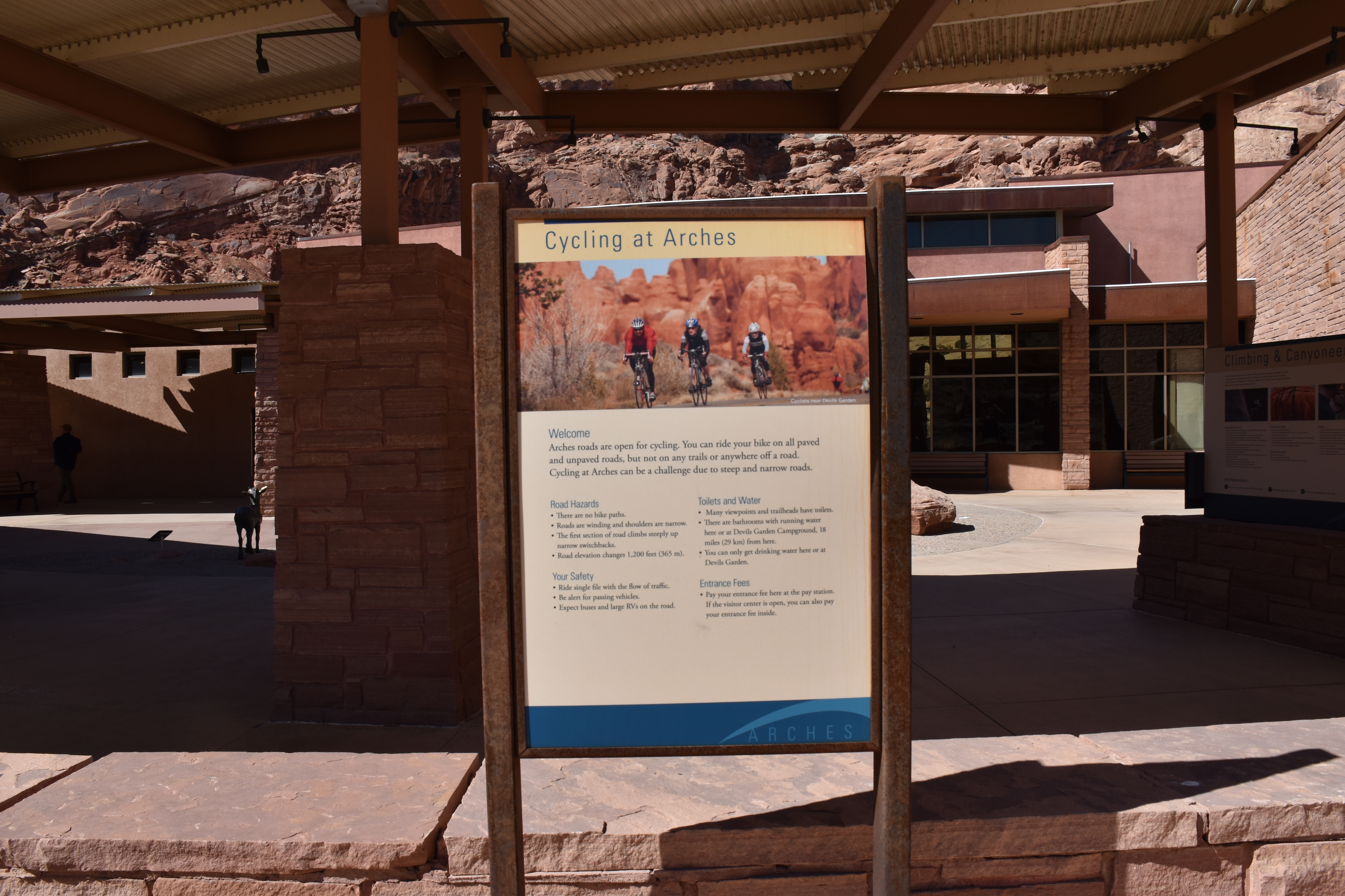
Cycling Overview. 425 words. 6 sections. From the Climbing and Canyoneering panel, move to your right around the knee-wall to a section about Cycling. Included in this area are bike racks, access to a bike trail, and informative signage. The small panel in this area is titled Cycling at Arches. A photo depicts three helmeted cyclists biking down a paved road surrounded by large red sandstone rock forms. Below the photo, introductory text reads: Welcome. Arches roads are open for cycling. You can ride your bike on all paved and unpaved roads, but not on any trails or anywhere off a road. Cycling at Arches can be a challenge due to steep and narrow roads. Below the introductory text are four cycling-related topics, each followed by a list of information. End of section. The first topic, Road Hazards, heads the following the list: 1. There are no bike paths. 2. Roads are winding and shoulders are narrow. 3. The first section of road climbs steeply up narrow switchbacks. 4. Road elevation changes 1,200 feet or 365 meters. End of section. The second topic, Your Safety, heads the following the list: 1. Ride single file with the flow of traffic. 2. Be alert for passing vehicles. 3. Expect buses and large RVs on the road. End of section. The third topic, Toilets and Water, heads the following the list: 1. Many viewpoints and trailheads have toilets. 2. There are bathrooms with running water here or at Devils Garden Campground, 18 miles or 29 kilometers from here. 3. You can only get drinking water here or at Devils Garden. End of section. The final topic, Entrance Fees, reads: Pay your entrance fee here at the pay station. If the visitor center is open, you can also pay your entrance fee inside. End of section. To reach the next exhibit, Exterior Zone 9, Arches Wildlife, navigate back around the knee-wall and past the Climbing and Canyoneering exhibit until you encounter ground surface texture, from the concrete walkway to a rougher, rocky surface. This rocky surface is part of an island next to the walkway filled with animal sculptures and boulders, which are described in the next track. Navigate around the rocky surface, keeping it to your right, as you move back to the main walkway. When you reach the main walkway, turn right and proceed to the back side of the next partition on your left, which tells the story of the sculpted animals as well as other park species. End of description.
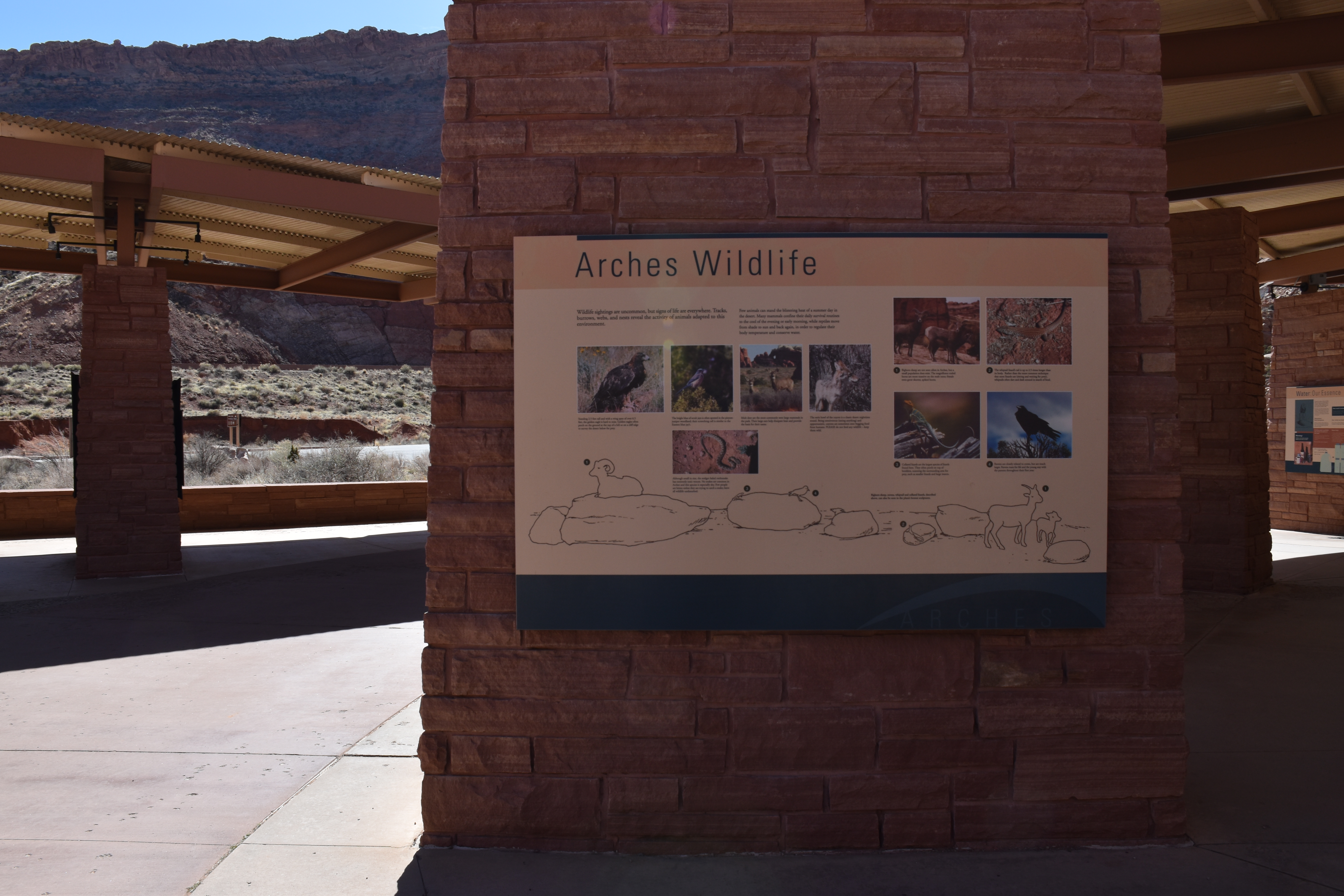
Arches Wildlife Overview. 323 words. 4 sections. As you move along the central walkway toward the end of the pavilion, you will encounter a substantial change in the ground surface texture to your right. Between the Climbing and Canyoneering exhibit and the entrance to the facility, the concrete walkway surface transitions to an island-shape with a rougher, rocky surface. Several large boulders and metal animal sculptures are located on the island, so move with caution. Also be aware this area is not covered, so it is more vulnerable to weather conditions. A small sign next to one of the boulders reads: Caution! Metal animal sculptures may be hot. End of section. The animals arranged on and around the boulders are all life-sized. If you are standing next to the panel, from left to right, the animals represented in the sculptures are a large male bighorn sheep with curled horns resting on a boulder, a small collared lizard on one end of a rock with a raven on the other, a whiptail lizard gazing up at the raven from a smaller stone, and at the end, a female bighorn sheep looks in your direction accompanied by a young sheep. They are explored in more detail on the last panel titled Arches Wildlife to your left. End of section. The introductory text to the panel reads: Wildlife sightings are uncommon, but signs of life are everywhere. Tracks, burrows, webs, and nests reveal the activity of animals adapted to this environment. Few animals can stand the blistering heat of a summer day in the desert. Many mammals confine their daily survival routines to the cool of the evening or early morning, while reptiles move from shade to sun and back again, in order to regulate their body temperature and conserve water. End of section. To learn more about the animal represented in the sculptures and other animals in the park, access the menu. End of description. Exterior Zone 9 Menu Details about the Sculpted Animals. 286 words. Other Arches animal species. 349 words. [9a] Details about the Sculpted Animals Details about the Sculpted Animals. 286 words. 5 sections. The sculpted animals are represented on the lower portion of the panel by an illustration that notes each species with a number, which is further detailed with a photo and description above the illustration. End of section. Number 1 is bighorn sheep. The photo depicts three brown bighorn sheep on a red stone surface. Text reads: Bighorn sheep are not seen often in Arches, but a small population does exist. The magnificent curled horns are more massive on the male rams; female ewes grow shorter, spiked horns. End of section. Number 2 is whiptail lizard. The photo depicts a speckled brown, gray, and white lizard sunning itself on a rocky surface. Text reads: the whiptail lizard's tail is up to 2.5 times longer than its body. Rather than the more common technique that most lizards use, such as sitting and waiting for prey, whiptails often dart and dash around in search of food. End of section. Number 3 is collared lizard. The photo depicts a striped green and yellow lizard with an orange head, looking behind itself as it grips onto a branch in a semi-standing position. Text reads: collared lizards are the largest species of lizards found here. They often perch on top of boulders, scanning the surrounding area for prey, such as smaller lizards and large insects. End of section. Number 4 is raven. The photo depicts a large black bird, clinging to the top branches of a juniper tree and looking into the distance. Text reads: Ravens are closely related to crows but are much larger. Ravens mate for life and the young stay with the parents throughout their first year. End of description. [9b] Other Arches Animal Species Other Arches animal species. 349 words. 6 sections. The left side of the panel presents photos of five other species that live at Arches, each one represented with a photo and related information. End of section. The first photo shows a golden eagle in the desert grass. It has a hooked beak, long talons, and black and gold feathers. Text reads: Standing 2.5 feet tall and with a wing span of over 6.5 feet, the golden eagle is hard to miss. Golden eagles often perch on the ground at the top of a hill or on a cliff edge to survey the desert below for prey. End of section. The second photo shows a scrub jay, a small bird with blue feathers of varying shades perched on top of a tree. Text reads: The bright blue of scrub jays is often spotted in the pinyon-juniper woodland; their screeching call is similar to the Eastern blue jay's. End of section. The third photo shows two mule deer in a canyon setting. They have tan fur and large erect ears. Text reads: Mule deer are the most commonly seen large mammals in the park. Their large ears help dissipate heat and provide the basis for their name. End of section. The fourth photo shows a coyote in the woodlands looking off to the side, with its ears turned back. Its coat is silvery and brown. Text reads: The eerie howl of the coyote is a classic desert nighttime sound. Being omnivorous, meaning eating anything, and opportunistic, coyotes are sometimes seen begging food from humans. Please do not feed any wildlife. Keep them wild. End of section. The fifth and final photo shows a rattlesnake on a red stony ground surface. The snake’s head is shaped like a shovel and his skin is patterned with brown spots. Text reads: Although small in size, the midget faded rattlesnake has extremely toxic venom. No snakes are common in Arches and this species is especially shy. Few people are bitten unless they are trying to catch a snake; leave all wildlife undisturbed. End of description.
Walk a short path behind the visitor center to learn about native desert plants and their traditional uses. Roundtrip Distance: 150 feet (45 m) Time: 10 min Elevation Change: 0 ft (0 m)
Balanced Rock is visible from the park road. Although parking is limited, many visitors stop to complete the short hike around the feature's base for unusual and up-close perspectives. This loop trail is partly paved and may be accessible to wheelchairs. Climbing on Balanced Rock is prohibited. Roundtrip Distance: 0.3 mi (0.4 km) Time: 15-30 min Elevation Change: 35 ft (11 m)
From the trailhead at the Sand Dune Arch parking area, the trail crosses a large meadow to Broken Arch. You can return from there or continue through the arch to the campground, then circle back through fins with sand dunes and some moderate scrambling. Roundtrip Distance: 1.2 mi (1.9 km) Time: 30-60 minutes Elevation Change: 59 ft (18 m)
This is the north end of the Park Avenue Trail, which traces a mostly smooth canyon bottom uphill, then ascends rock-cut stairs to Park Avenue Viewpoint. For an easier walk, turn around at the base of the stairs. Roundtrip hikers: please remain on the trail both directions rather than walking along the road. Roundtrip Distance: 1.8 mi (3.2 km) Time: 1 hour Elevation Change: 322 ft (98 m) -- or much less if you skip the stairs
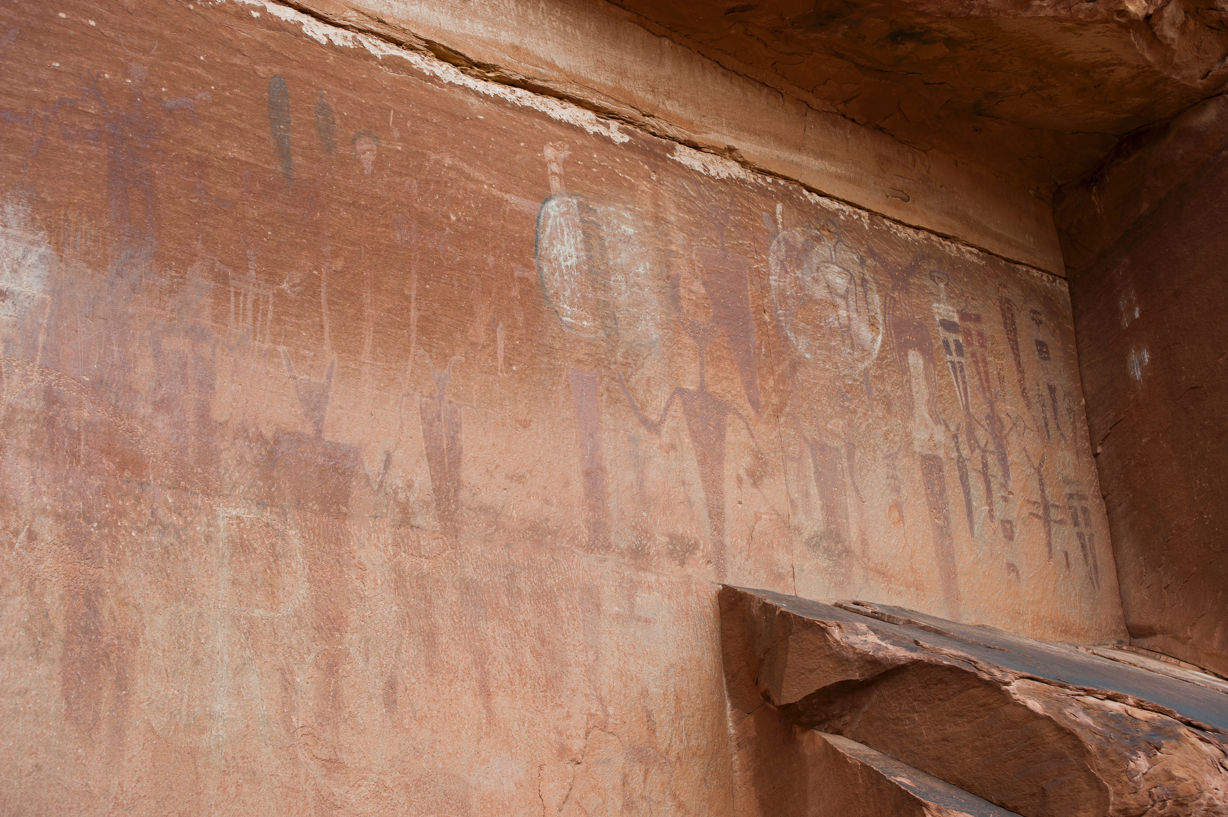
A rock markings panel above the Colorado River offers insight into the lives and movements of archaic peoples. View the panel from below (better with binoculars) or hike a short trail up to its base. First part of trail is paved and accessible to wheelchairs. Roundtrip Distance: 0.8 mi (1.4 km) Time: 30-60 min Elevation Change: 60 ft (18 m)
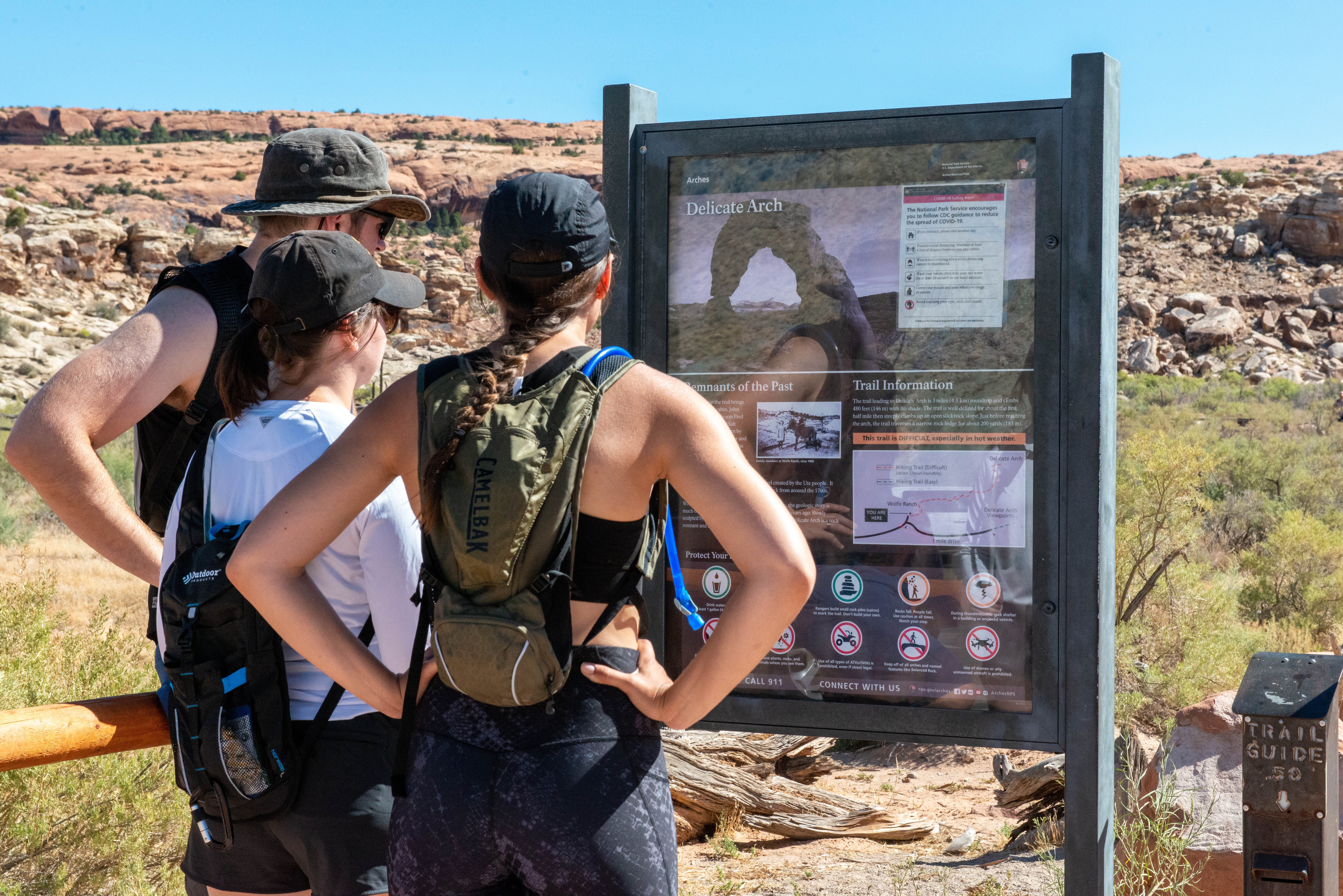
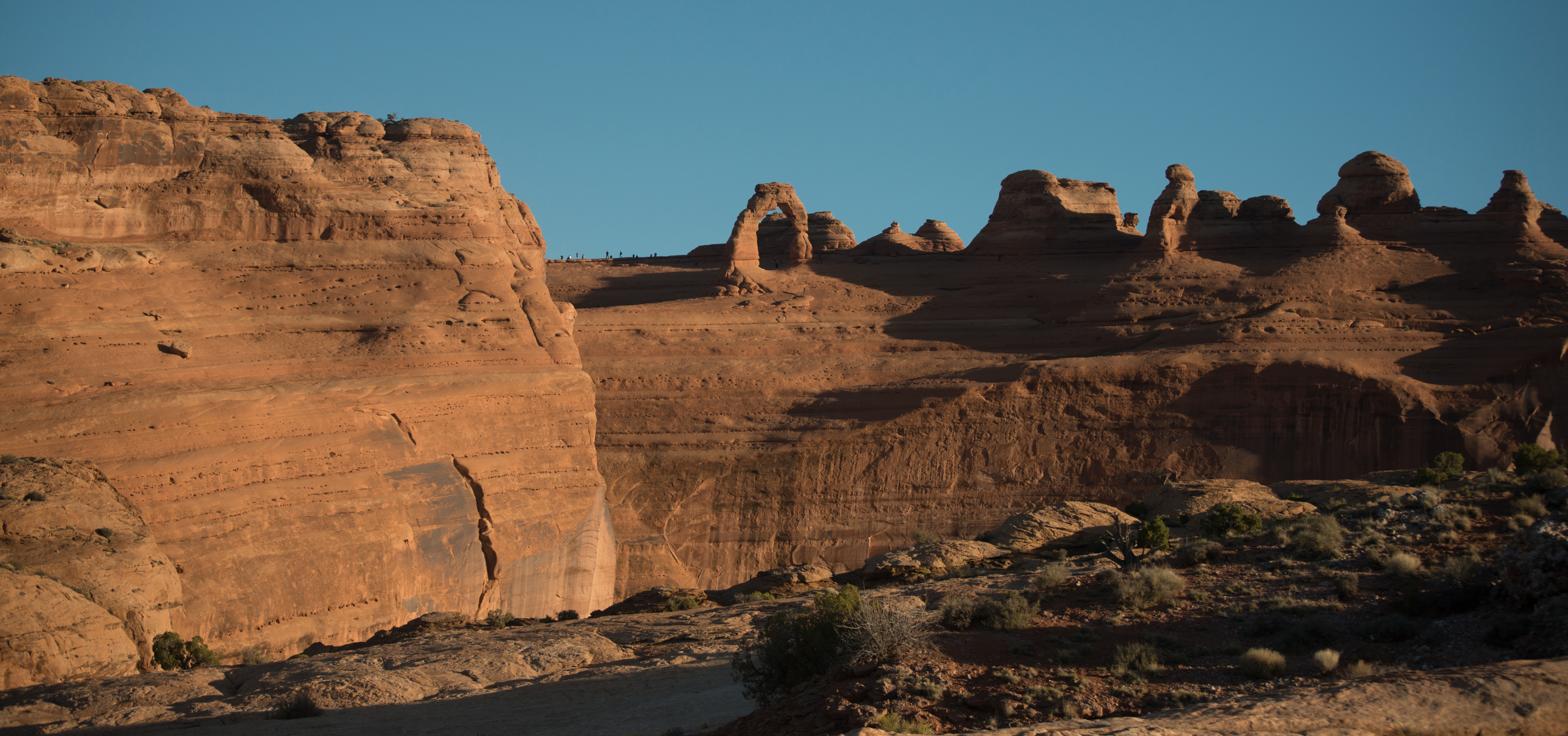
This trail hikes up 538 feet (164 m) to the most famous arch in the park, crossing open slickrock with no shade. Pass historic Wolfe Ranch and a rock markings panel, then climb steadily; follow the rock cairns and signs. Just before you get to Delicate Arch, the trail traverses a narrow rock ledge for about 200 yards (183 m). Take at least 2 quarts (2 L) of water per person. Roundtrip distance: 3 miles (4.8 km) Time: 2-3 hours
See the most famous arch in the park at a distance from one of these viewpoints. Lower Viewpoint is level and wheelchair-accessible; with a roundtrip distance of 200 ft (61 m). Upper Viewpoint is moderately strenuous: Roundtrip Distance: 0.5 mi (0.8 km) Time: 30-45 min Elevation Change: 171 ft (52 m)
This trailhead offers a range of hikes, from short to strenuous. Beyond Landscape Arch (listed above), the trail climbs sandstone slabs. Footing is rocky, with narrow ledges, exposure to heights, rock scrambling, and few trail markers. Avoid when rock is wet or snowy. Bring at least 3 quarts (3 L) of water per person. Roundtrip just to Double O Arch: 4.0 miles (6.4 km), 2-3 hours. Whole Trail: 7.9 miles (12.7 km), 3-5 hours
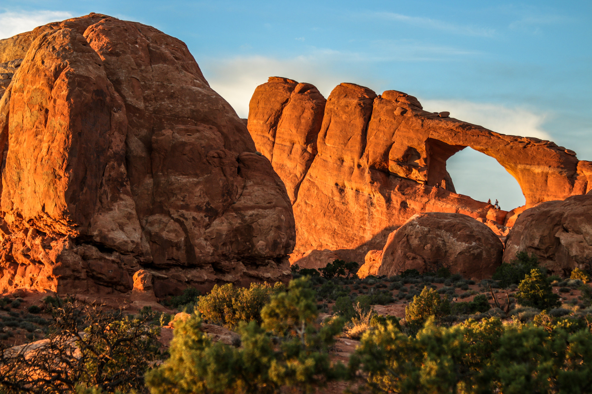
The tallest arch in the park at 122 ft (34 m), Double Arch is visible from The Windows parking loop. A relatively flat, gravel-surfaced path leads to the base of its two huge, arching spans. May be accessible to wheelchairs with some assistance. Roundtrip Distance: 0.6 mi (1 km) Time: 15-30 min Elevation Change: 30 ft (10 m)
The Fiery Furnace is a labyrinth of narrow sandstone canyons that requires agility to explore. One route is marked, but getting lost is still possible. Entering the Fiery Furnace requires tickets for a ranger-led hike or permits for exploring on your own. Both must be reserved in advance through Recreation.gov.
La Sal Mountains Viewpoint is located a short distance inside the park and offers an excellent overview of red rock scenery both inside and outside the park.
A hard-packed trail leads to a spectacular ribbon of rock, whose span is longer than 300 feet (91 m). Spur trails lead to Pine Tree Arch and Tunnel Arch. Steep slopes may be accessible to wheelchairs with assistance. After Landscape Arch, the Devils Garden Trail becomes difficult, with rock scrambling, narrow ledges, and exposure to heights. Roundtrip Distance: 1.8 mi (2.9 km) Time: 30-60 min Elevation Change: 40 ft (12 m)
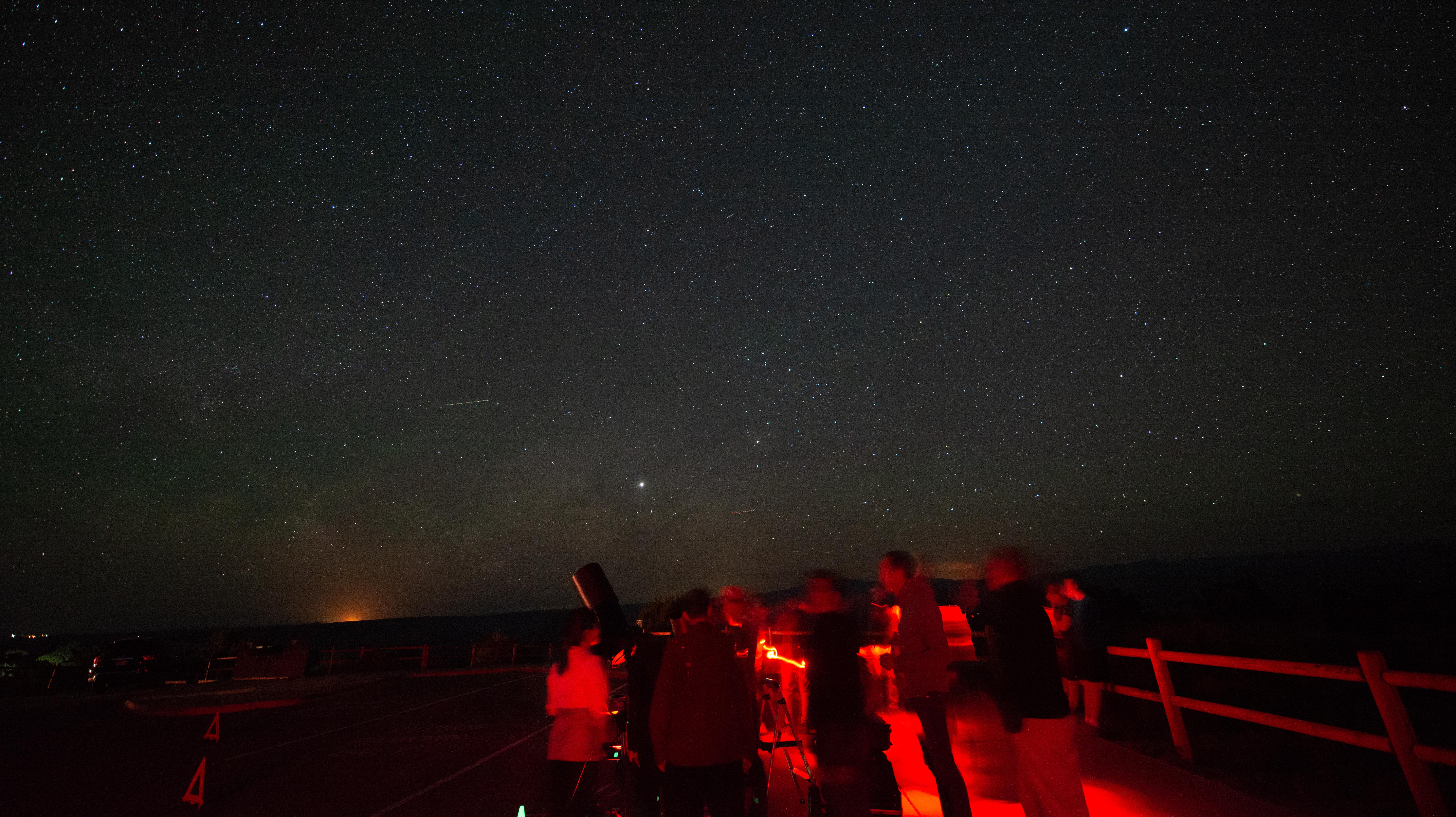
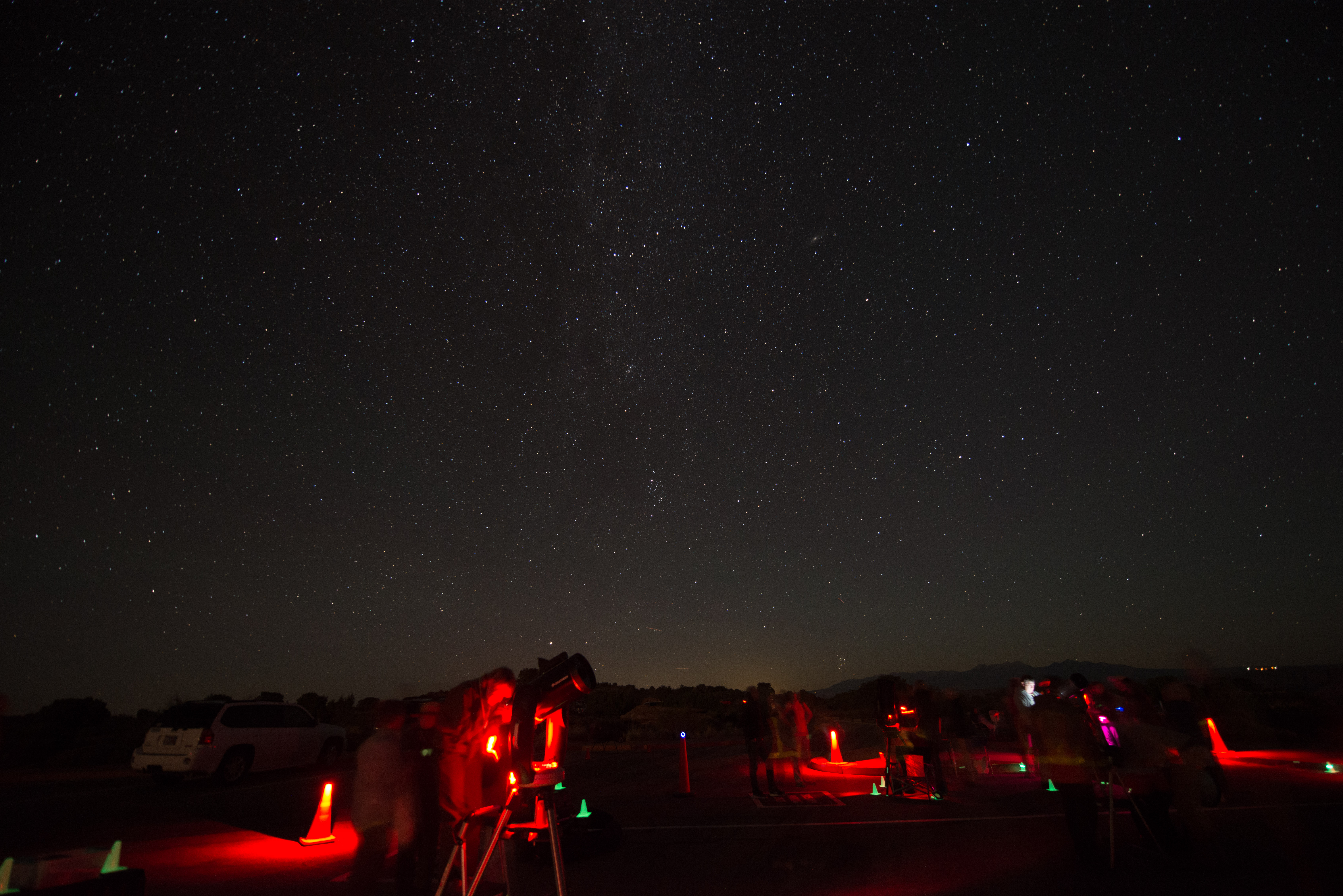
Panorama Point offers wide-open views of Arches and the surrounding area. Located at the top of a hill, you can enjoy views of the La Sal Mountains, the Fiery Furnace, and even Devils Garden from your vehicle or at viewpoints along the parking area. Panorama Point is also an excellent place to stargaze and take in the night sky.
A paved sidewalk (wheelchair accessible) leads to a viewpoint down a corridor of towering rock walls and spires. Descend stairs to walk the trail among massive monoliths toward Courthouse Towers Viewpoint. For a roundtrip hike, return along the trail rather than walking along the road. Roundtrip Distance: 1.8 mi (3.2 km) Time: 1 hour Elevation Change: 322 ft (98 m)
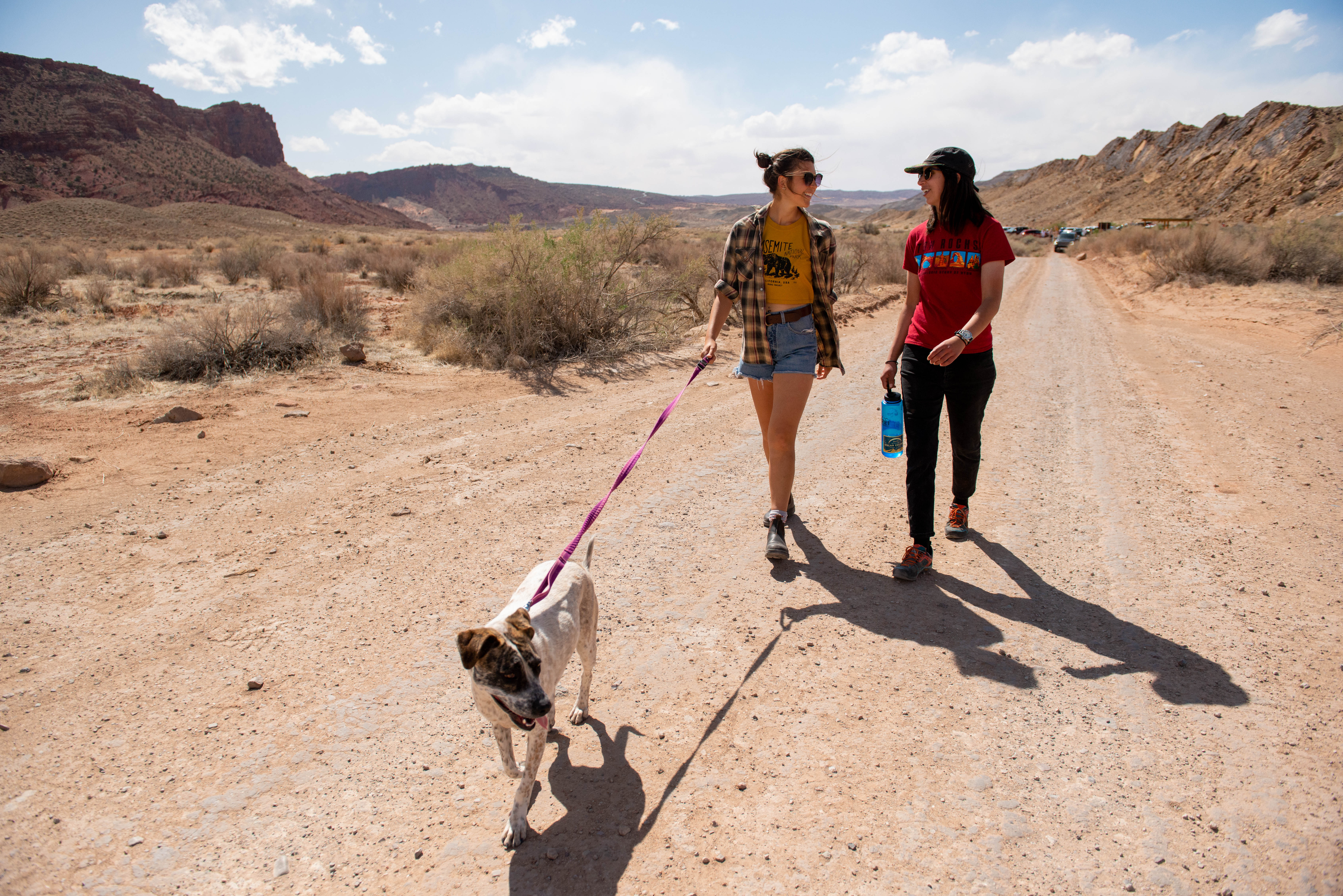
Pets and owners have a special bond, but a national park is not always the best place for pets. Arches National Park is a designated natural area, and its purpose is to preserve and protect the park's natural environment, cultural resources, wildlife, and scenic beauty. When in Arches, it is your responsibility to know and adhere to all rules and regulations regarding pets in the park.
Hike through deep sand to find this hidden arch between tall sandstone walls. You may also choose to continue across a grassland to Broken Arch, returning via the same trail or making a loop through the campground. Roundtrip Distance: 0.4 mi (0.6 km) Time: 15-30 min Elevation Change: 0 ft (0 m)
A short, out-and-back hike on well defined trail leads to an arch in a high wall. On a cold night in November 1940, a large chunk fell out of this arch, instantly doubling the size of its opening. Roundtrip Distance: 0.4 mi (0.6 km) Time: 10-20 min Elevation Change: 28 ft (8 m)
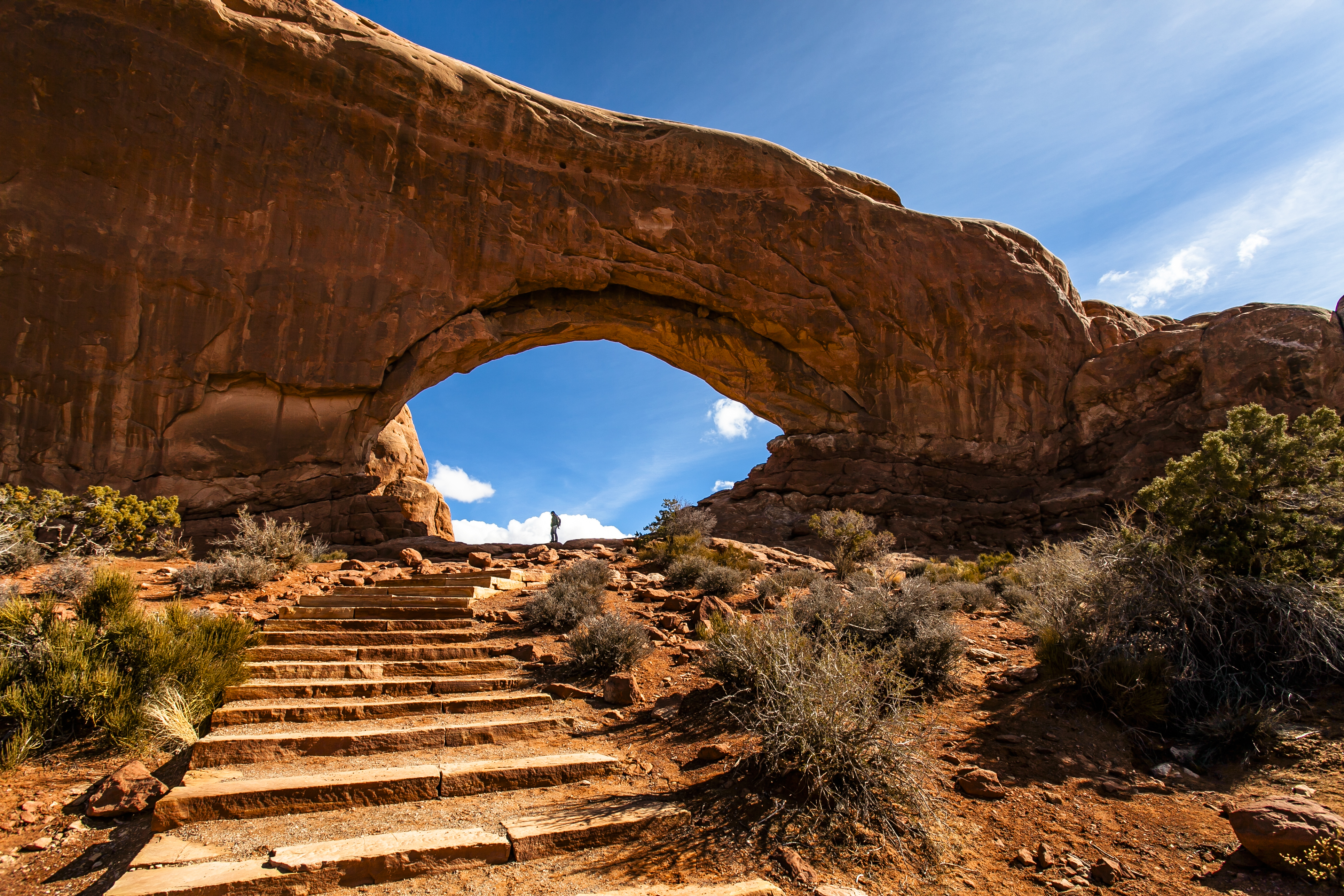
Massive North Window is visible from the parking lot. A gentle climb up a hard-packed trail and stone steps leads to North Window, South Window, and Turret Arch. Return to the parking lot via the same trail, or take the slightly longer primitive route around the back side. First 300 feet (91 m) of main trail may be accessible to wheelchairs with assistance. Roundtrip Distance: 1 mi (1.6 km) Time: 30-60 min Elevation Change: 99 ft (30 m)
Visiting Arches? From April 1–July 6 and August 28–October 31, 2025, you'll need a Timed Entry Ticket to enter the park. This pilot timed entry system is designed to help manage traffic and improve visitor experiences.
Visiting Arches? From April 1 through July 6 and August 28 through October 31, 2025, you'll need a Timed Entry Ticket to enter the park. This pilot timed entry system is designed to help manage traffic and improve visitor experiences. The pilot applies to the Arches National Park Scenic Drive that runs through the park.
This trail climbs up a rock wall, cuts across a valley, and then meanders through sandstone fins and sand dunes. Reaching this trailhead requires driving 8 mi (14 km) on unpaved roads, which wash out quickly in rainstorms. Roundtrip Distance: 2.6 mi (4.2 km) Time: 2-3 hours Elevation Change: 290 ft (89 m)
This humble, one-room cabin sits near the present-day trailhead for the hike to Delicate Arch. Visitors regularly peer through the doorway and wonder aloud, "Who lived here... and how?... And why?" For more than a decade, John Wesley Wolfe and his family lived and worked on the remote "Bar DX" ranch, eventually grazing more than 1,000 head of cattle on native grasses that once covered this area.
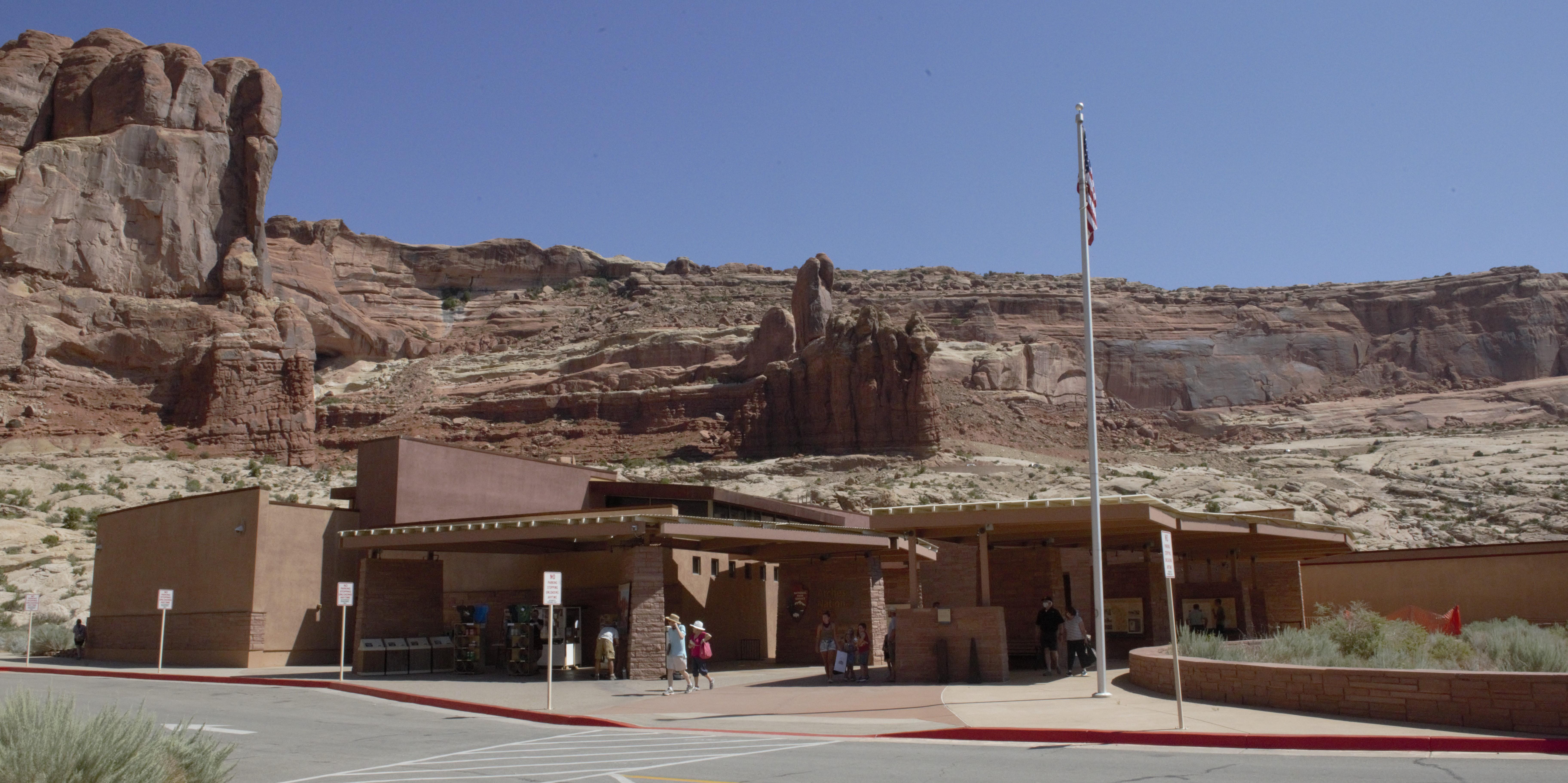
The visitor center is generally open every day except December 25. Hours vary by season. You can learn about the park from exhibits and a bookstore. Rangers are on duty to answer your questions. Restrooms and drinking water are available.
Rangers occasionally lead stargazing programs and events at parks throughout southeast Utah. Learn about what to expect and check out a schedule of stargazing events at Arches and Canyonlands national parks and Hovenweep and Natural Bridges national monuments. Even when formal programs are not offered, people are welcome to enjoy the parks after dark on their own.
Backpacking at Arches
Backpacking at Arches is allowed in designated sites only and requires a permit.
Canyoneering at Arches
Arches has no real "slot canyons" but does afford some unique on-rope opportunities.
Rock Climbing at Arches
Most climbing routes in the park require advanced techniques. Climbing is not allowed on any arches or certain named features, such as Balanced Rock.
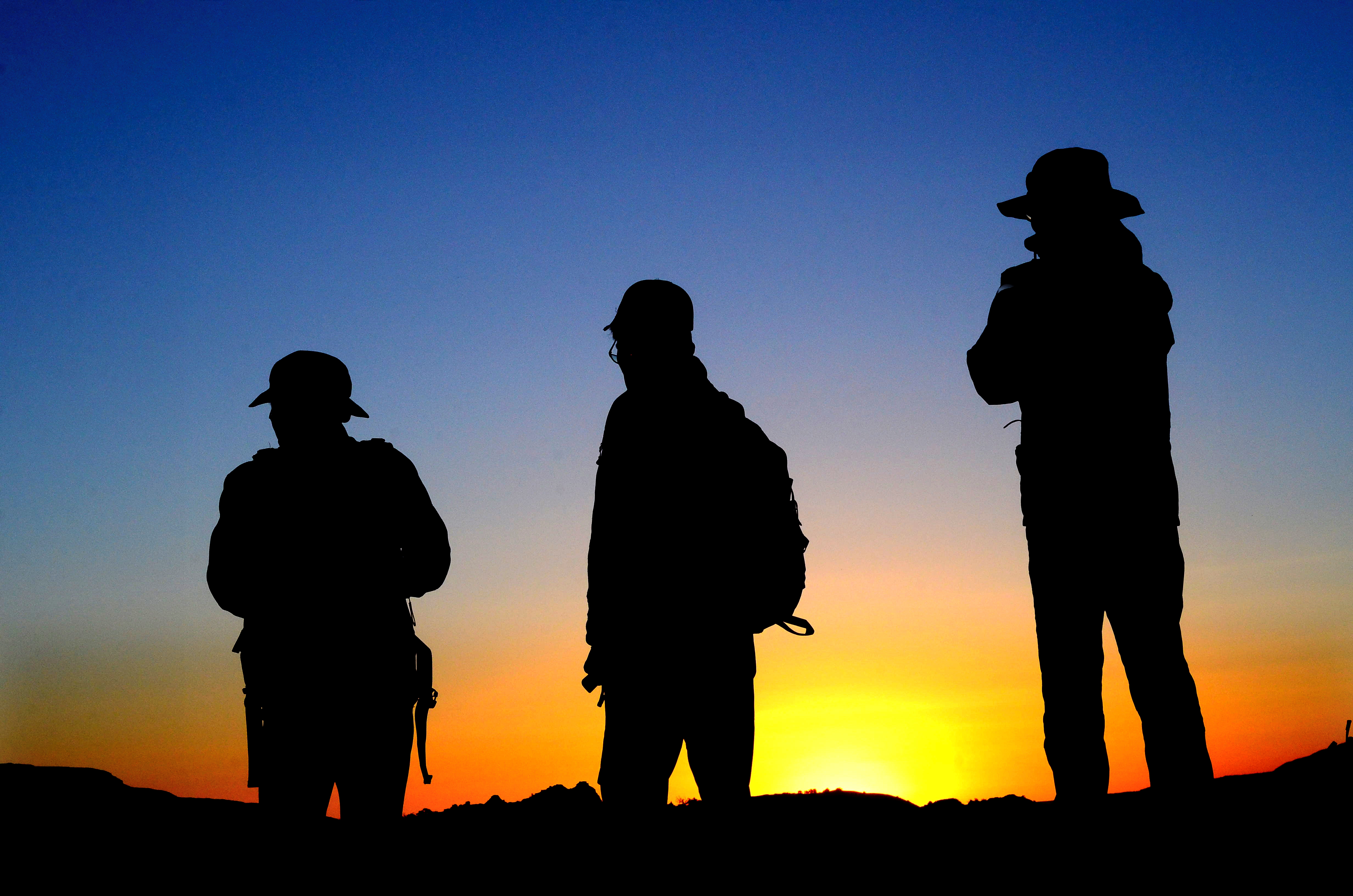
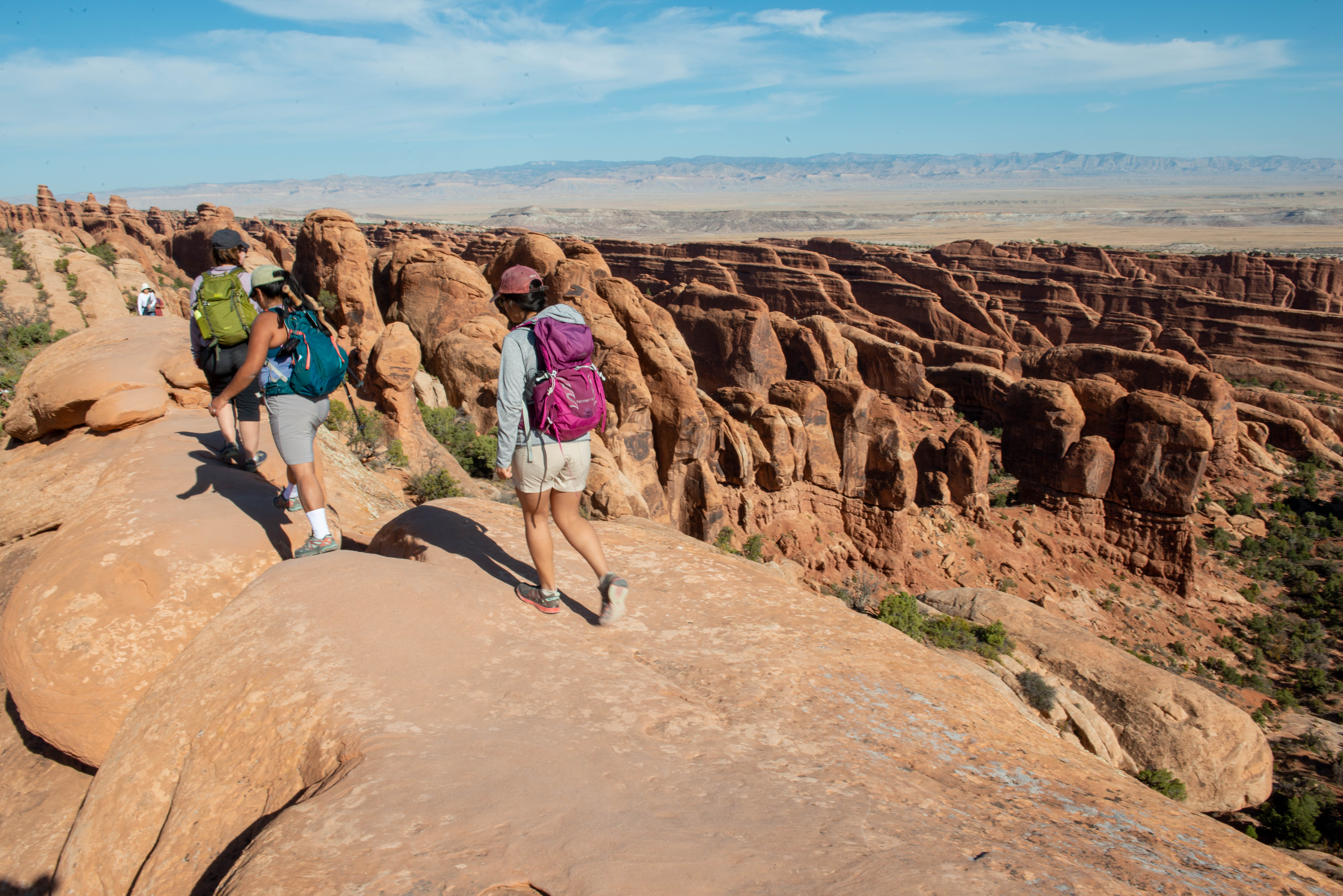
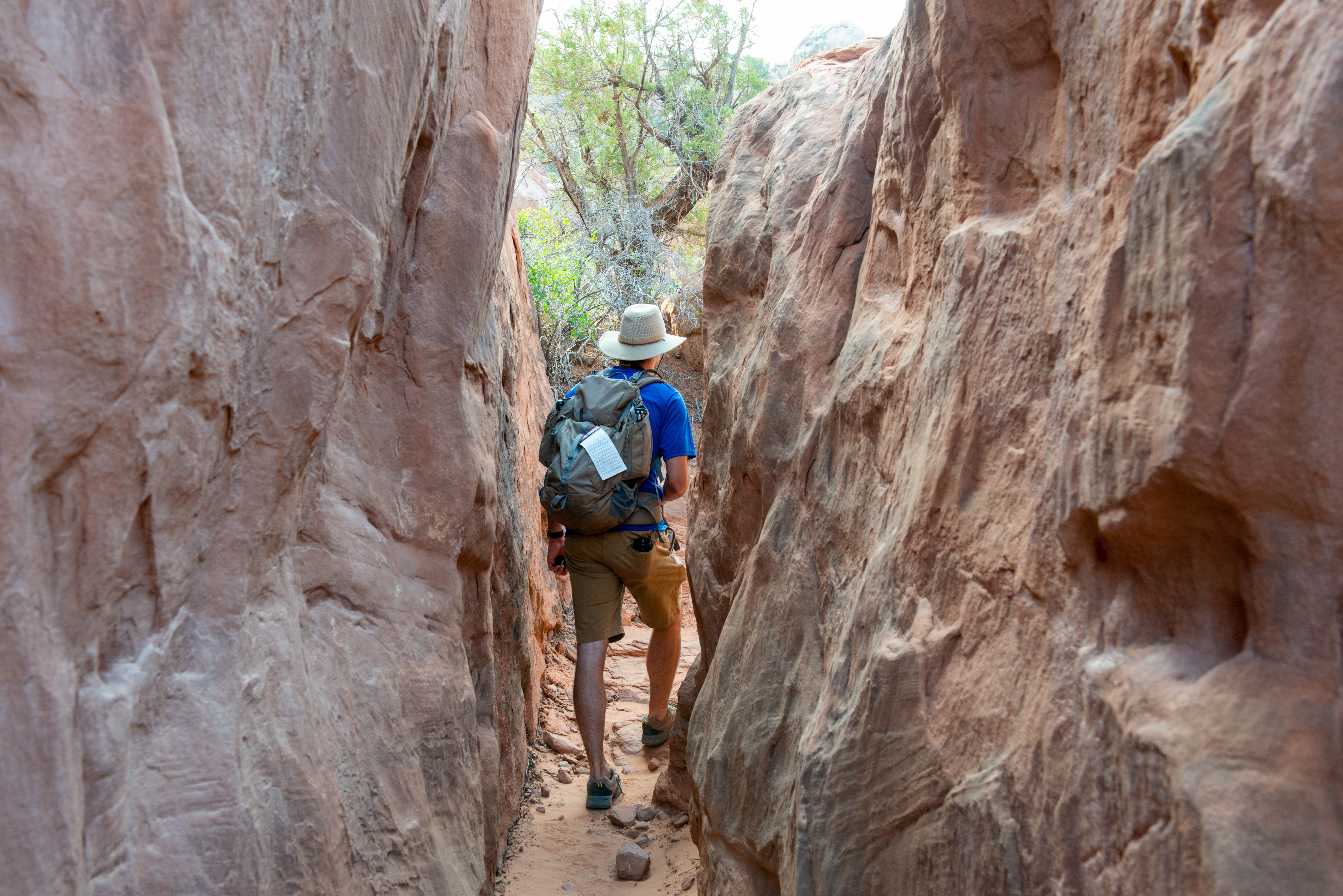
Hiking at Arches
Arches contains a variety of hiking trails, from easy/moderate to long and strenuous. Many trails use cairns (stacks of rocks) for markers and cross broad rock surfaces, requiring attention to follow. Learn how to Protect Yourself and Protect Your Park with hiking safety and Leave No Trace tips.
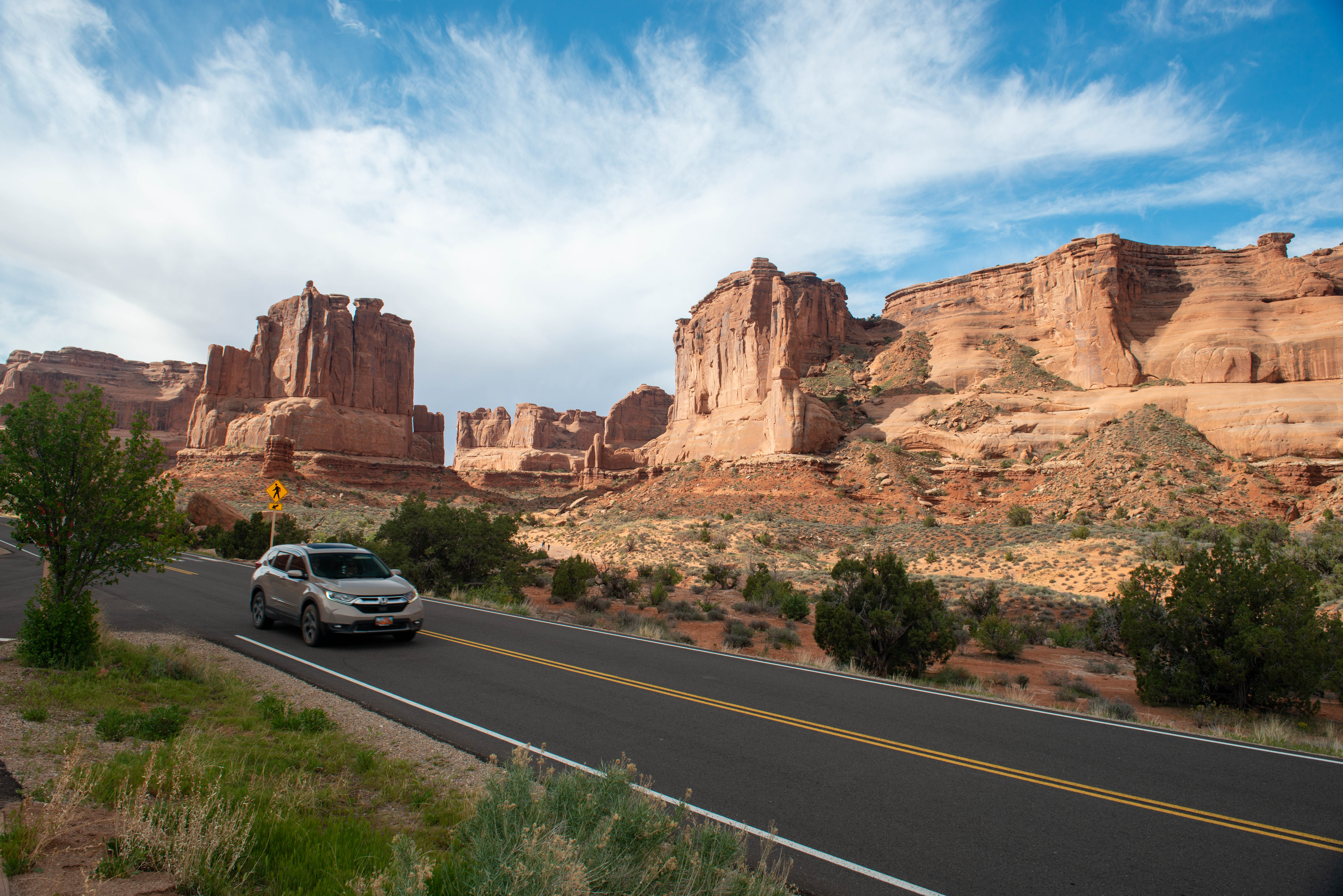
Enjoy Arches from the Road
If you pay close attention, you can see close to two dozen arches from the comfort of your car.
Explore the Fiery Furnace
Entry to the Fiery Furnace is managed by permits and ranger-led tours to ensure the experience of solitude and wilderness.
Start at Arches Visitor Center
Stop at the visitor center to plan your visit, fill your water bottle, learn about the park, and pick up a souvenir.
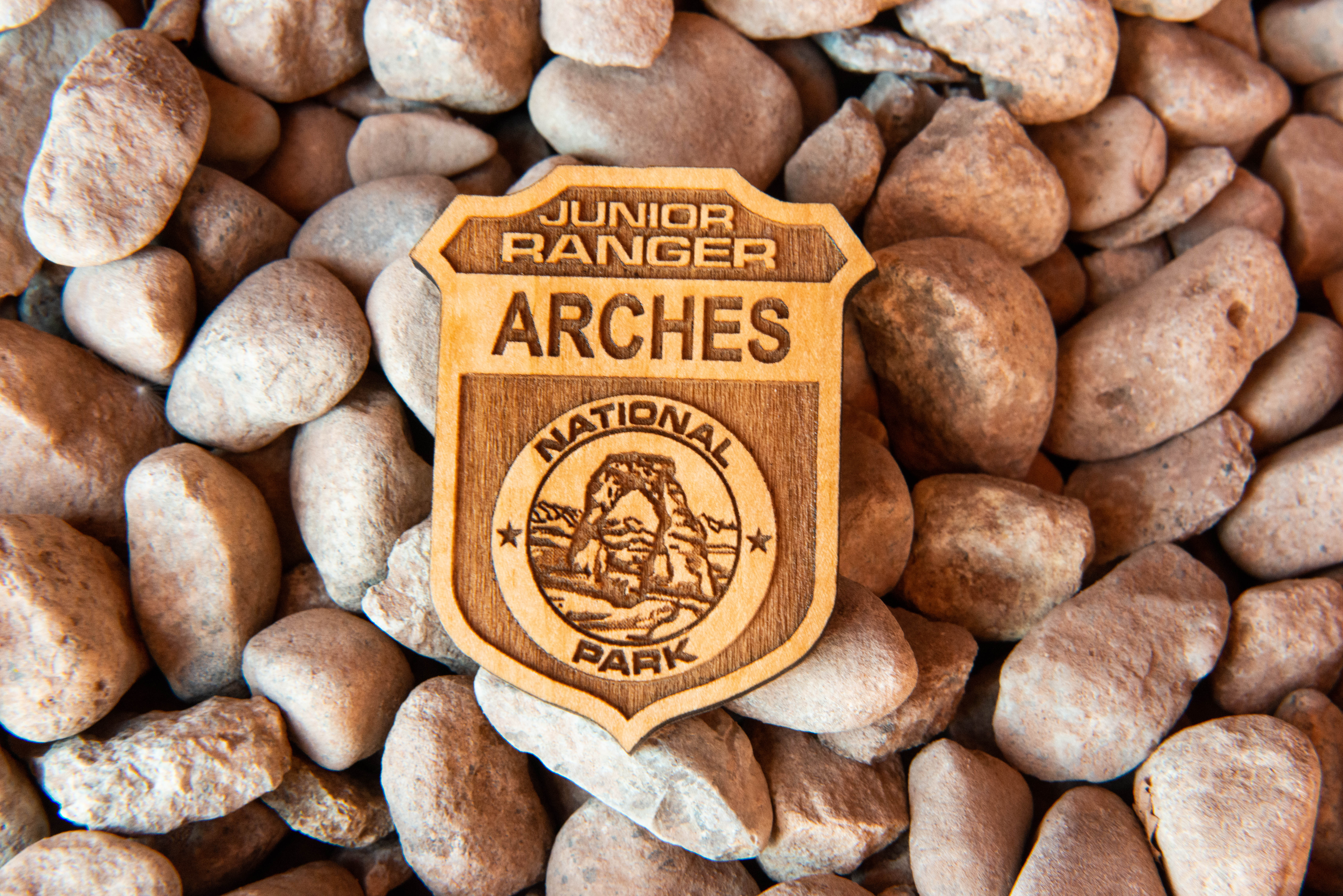
Arches Junior Ranger Program
Filled with fun activities, free Arches Junior Ranger books reveal the wonders of Arches to kids and parents alike.
Stargaze at Panorama Point
Arches National Park and the surrounding Colorado Plateau offer some of the darkest night skies remaining in the United States. You can enjoy the park after dark by viewing spectacular night skies.
Tours
Count: 2
Geology
Over two thousand natural sandstone arches, the greatest concentration of rock arches in the world, are preserved in Arches National Park. Arches is also home to an extraordinary collection of balanced rocks, salt dissolution structures, folds resulting from salt tectonics, petrified dune fields, and a maze of deep narrow canyons. Explore just a few of these features on a geologic tour of Arches.
Human History
Explore the depth of human history in Arches National Park. The archeological record tells us that humans have been travelling through and living in this stunning desert landscape for thousands of years. We also know that traditionally associated American Indian tribes have been here since time immemorial. Early settlers, cattle ranchers, and park founders also made a lasting impact on the landscape. Archeological sites are fragile resources. Never touch, leave artifacts in place, and watch your step.