Over 41 million acres are connected through the waters that flow to and through Chesapeake Bay. The National Park Service strives to connect people to the opportunities and adventures throughout the watershed. Inspiring stewardship across this va...
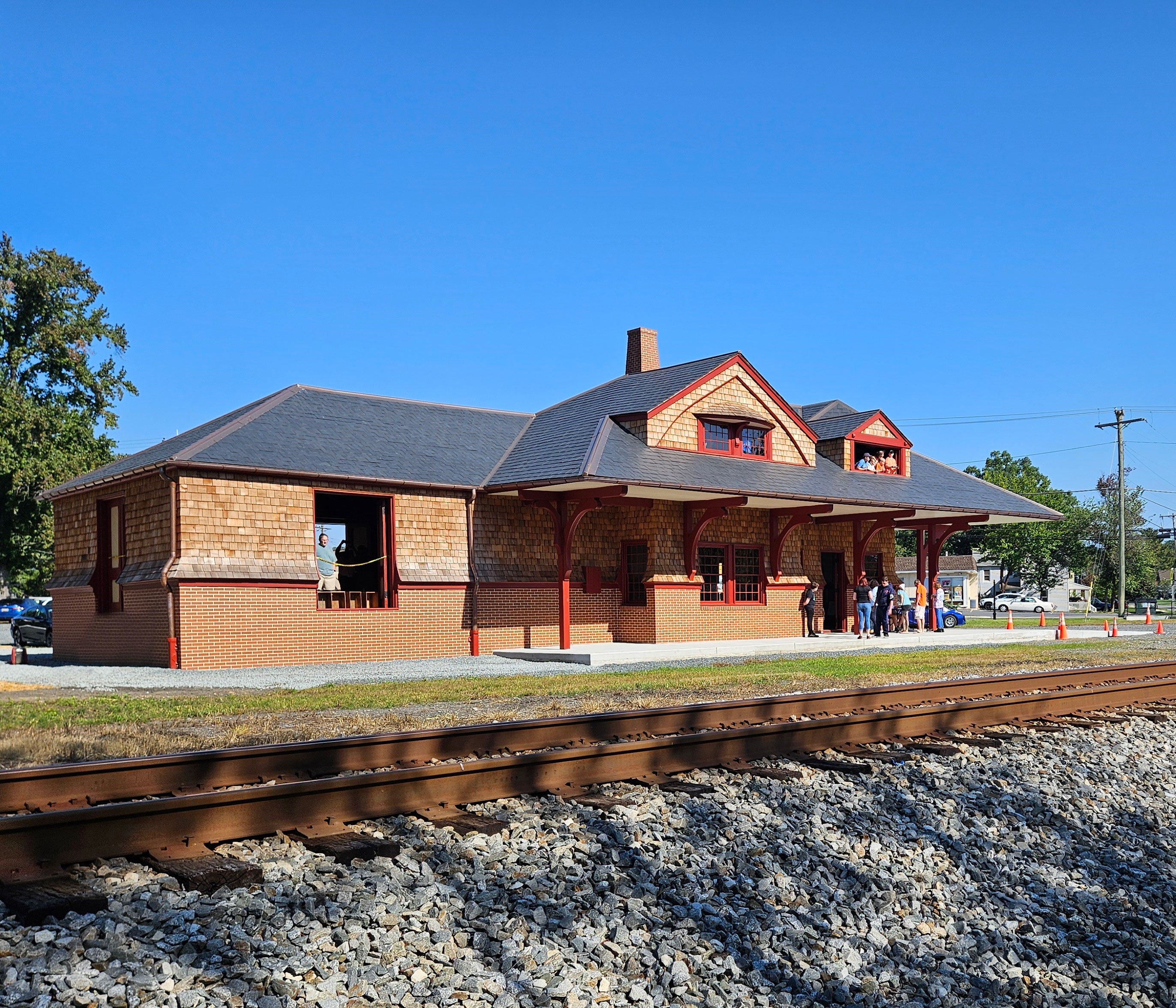
Step into Chesapeake Bay transportation history at the restored Aberdeen B&O Train Station. Explore railroading’s role in industry, military history, and community life while watching trains on active tracks. Discover a living link to the Bay’s economic and cultural evolution through engaging interpretation and historic architecture.
The image depicts a historical train station building on a clear, sunny day. The structure is made of brick and wood, with a slate-gray roof featuring two gabled dormer windows. The building's facade includes several large, open windows and a covered platform supported by red wooden beams. A group of people stands on the platform near the main entrance, and a person is visible through one of the open windows. In the foreground, there are train tracks composed of steel rails and gravel ballast. The background shows a clear blue sky and a few trees on the left and right.
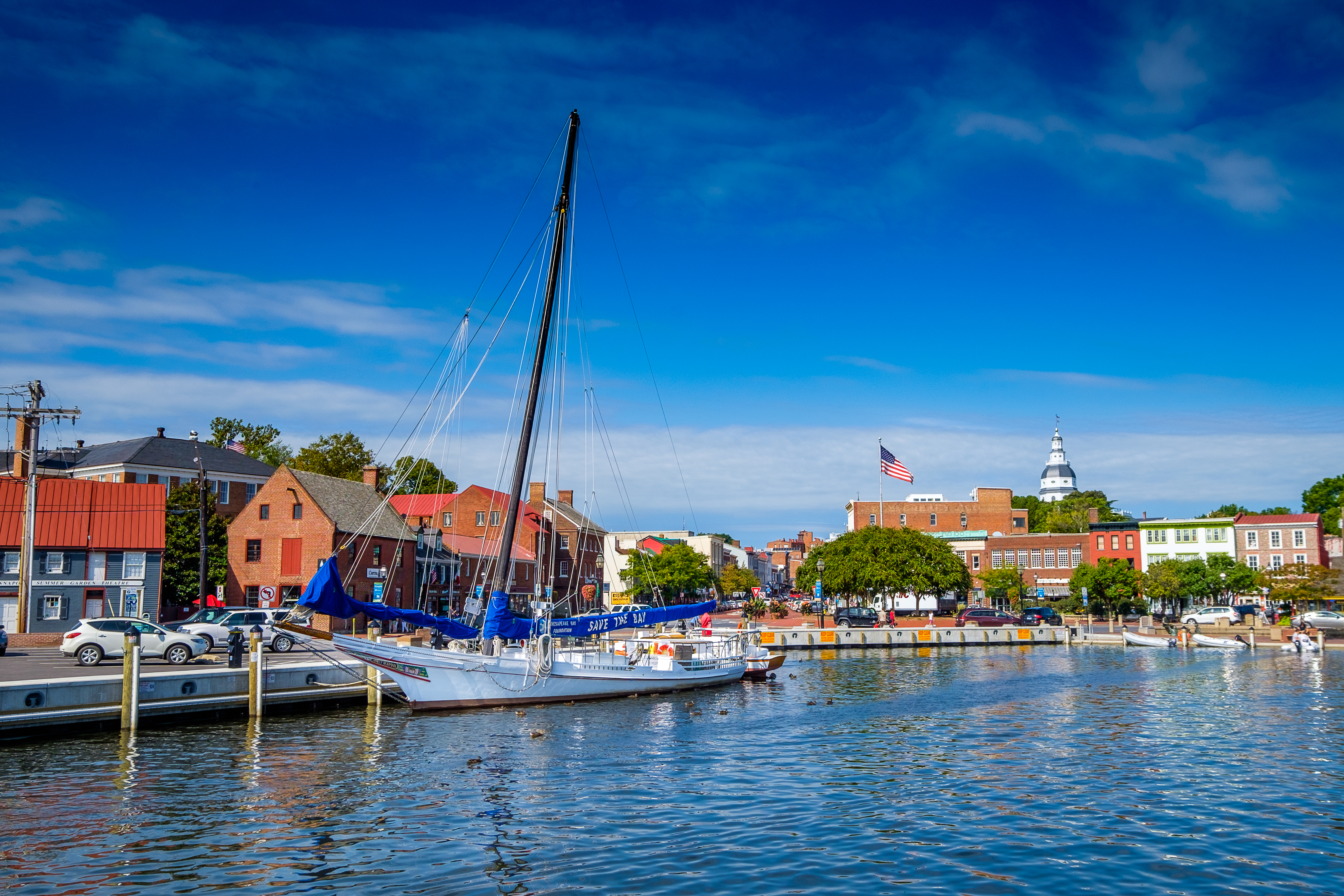
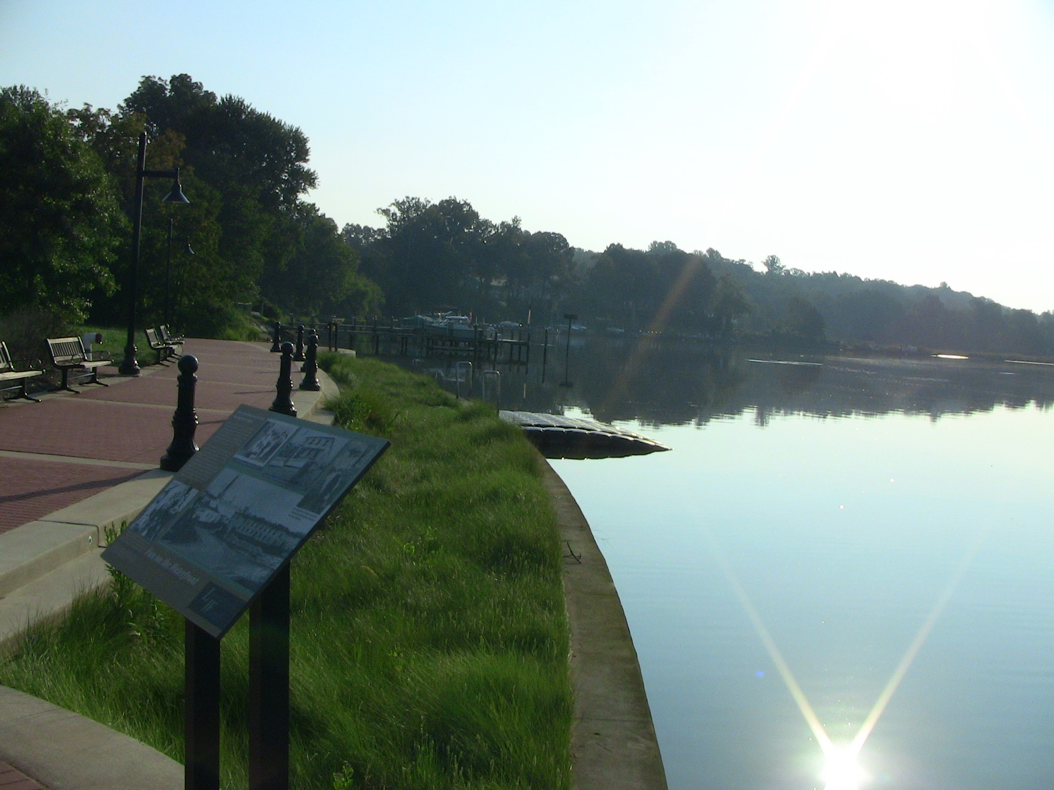
Annapolis City Dock is a bustling hub in the historic heart of Annapolis, MD. City Dock has served as an important port within Annapolis and the Chesapeake Bay region for at least 350 years. Today, City Dock continues to connect its residents with the waters of the Chesapeake Bay and businesses of the region.
Annapolis City Dock is a bustling wide outdoor-space surrounded by unique brick-buildings, shops, and restaurants. Many boats are found in City Dock with many making their way up a small water alley, known as “Ego Alley”. Many park benches and trees are also found at the tail end of City Dock.
In 1902, the first hospital in Annapolis opened on Cathedral Street. Its medical staff included Dr. William Bishop, the town’s leading African American physician. However, after Dr. Bishop’s death in 1904, the hospital no longer accepted Black physicians on staff. In 1910, a new hospital, built on the corner of Franklin and Cathedral, was open to all residents, but it had segregated wards and did not admit Black women for maternity care.
Trees and street lights designed to look historic line the side of Cathedral Street, where historic buildings are currently in use as commercial or residential properties. Many of these buildings are made of similar red brick, and have period typical features. On the south corner of Cathedral Street and Franklin Street is one such brick building with lighter framing around doors and windows and dark wrought iron fences over the lower floor windows and one upper floor balcony.
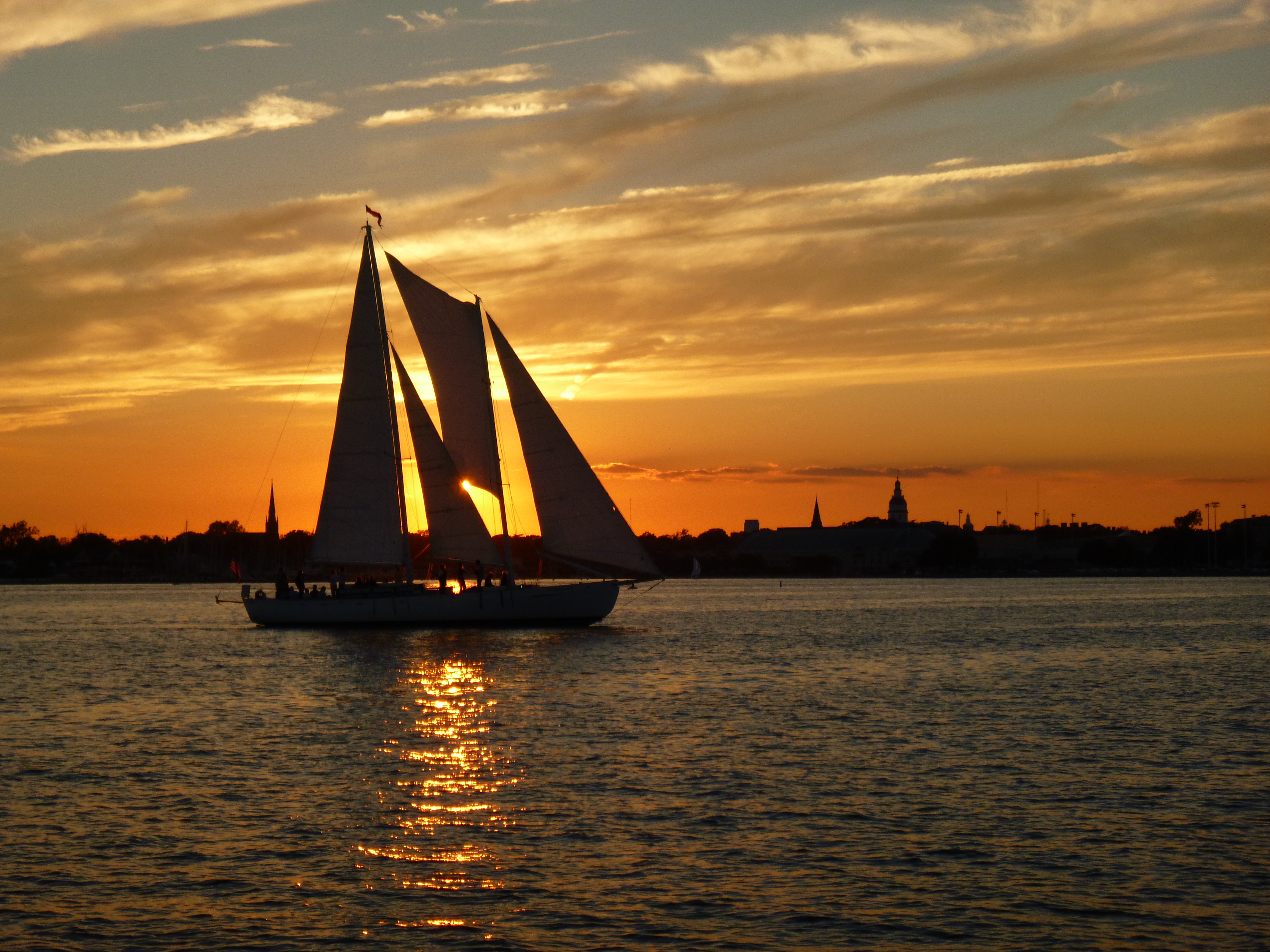
Sail the Chesapeake Bay aboard the Annapolis Sailing Cruise’s Schooner Woodwind classic wooden sailing yachts. Raise the sails, steer the boat, and explore stories of heritage, wildlife, and conservation with engaging captains and crew. Each trip at this Chesapeake Gateways Network Site offers a unique view of the Bay’s beauty and meaning.
The image captures a serene sunset scene with a sailboat prominently in the foreground. The sailboat is silhouetted against a vibrant orange sky, with the sun setting on the horizon, casting a warm glow across the water. The sky features scattered, wispy clouds streaked with hues of gold and orange. In the background, the faint outline of the Annapolis city skyline can be seen, with characteristic dome and spire shapes adding architectural interest. The water reflects the colors of the sky and the silhouette of the boat, enhancing the tranquil ambiance of the scene.
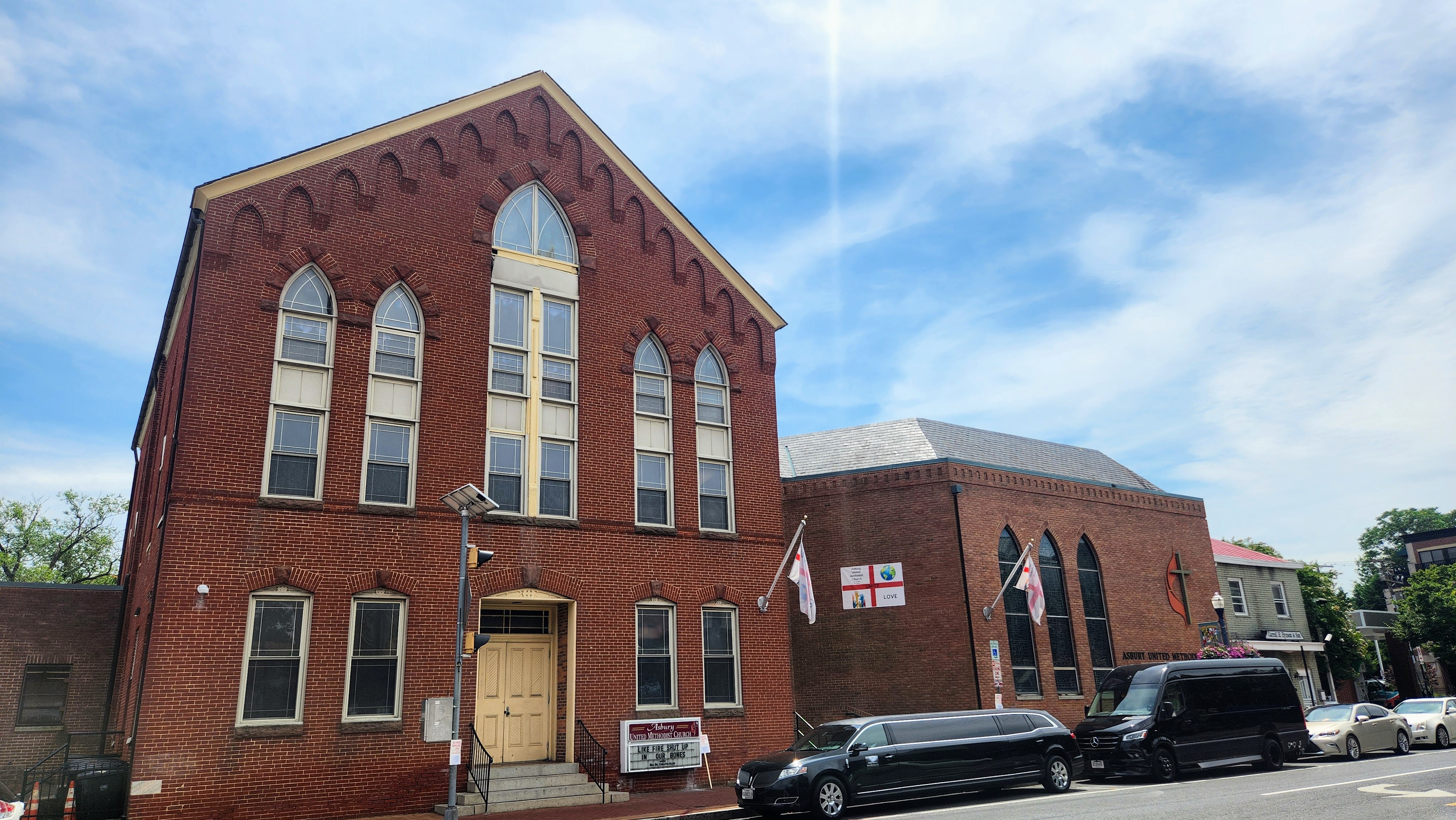
In 1803, seven free Black men bought land on West Street to establish the First African Methodist Episcopal Church in Annapolis. This current brick Gothic-style church, built in 1888 and expanded in 1976, is known now as Asbury United Methodist Church.
West Street is a multi-lane road with commercial properties that runs roughly east to west. Most of the buildings along this road are built of red brick, which also makes up part of the road at the crosswalks. On the northern corner where West Street meets W Washington Street there is a triangular board with information about the Old Fourth Ward, the area that West Street is currently in. On the other side of the street is a church with two small lancet windows on either side of a larger lancet window. The door to the church is inset in the center of the building with a few steps up from the sidewalk.
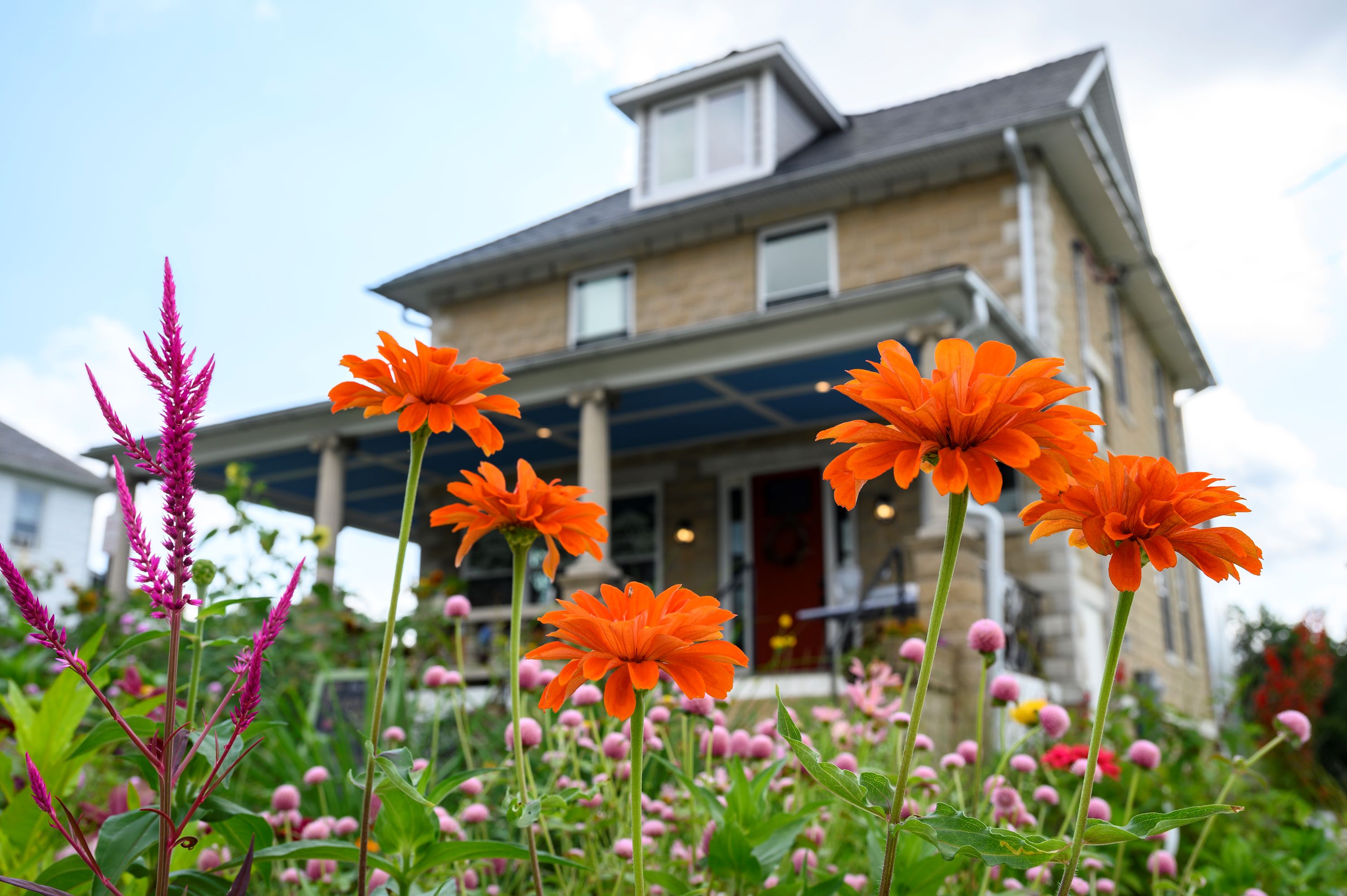
Discover BLISS Meadows, a 10-acre urban farm and land reclamation project in Northeast Baltimore. This unique space offers walking trails, farm animal interactions, and hands-on gardening workshops. Learn about sustainability, food justice, and the contributions of Black, Indigenous, and People of Color communities while enjoying fresh produce, honey, and community events. Experience nature, education, and social change in the heart of the Chesapeake Bay watershed.
The image shows a vibrant garden scene in front of a two-story house with a stone facade. In the foreground, bright orange flowers with layered petals stand tall amidst a mix of green foliage. To the left, a pink, spiky flower adds contrast and texture to the scene. Scattered among these are small, round, pink flowers. The house in the background has a dark gray roof and several windows. The entrance features a visible red door, framed by a porch supported by columns. The sky above is mostly clear with a few clouds, suggesting a sunny day.
Baltimore’s concentration of historic, cultural, and natural resources makes the city a truly unique place. The city has been witness to events that have dramatically altered the course of the nation’s history. Over the centuries it has also been witness to more subtle changes in the way Americans work, play, and live. With heritage area designation, both the state of Maryland and the U.S. Congress have acknowledged Baltimore for its capacity to tell these important stories.
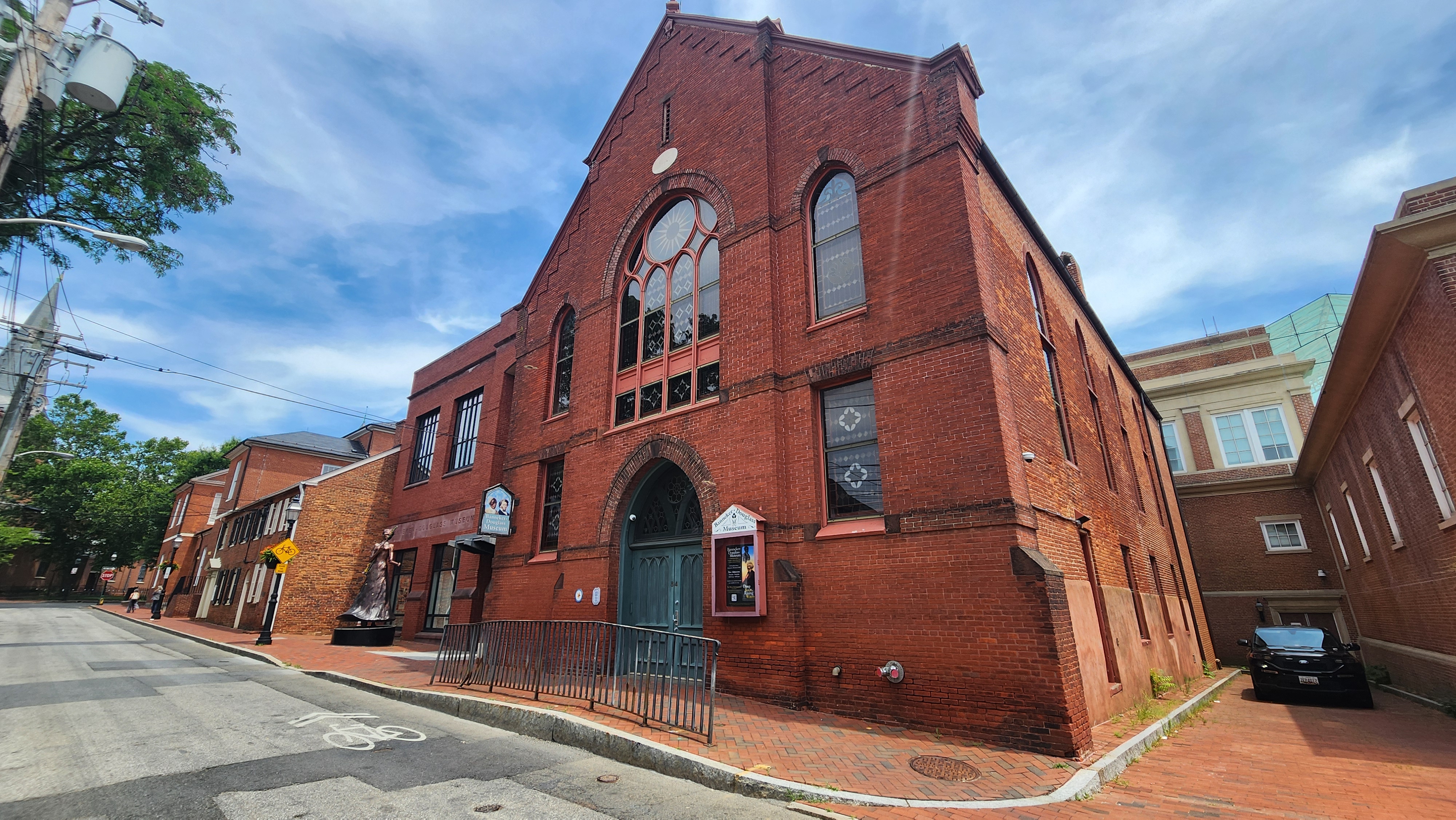
The Banneker-Douglass-Tubman Museum is the State of Maryland’s official museum of African American history and culture. Housed in the historic Mt. Moriah African Methodist Episcopal Church, the Museum features exhibits on history, art and Black life in Maryland.
Franklin Street is a narrow road with commercial and residential properties along both sides. On the southeast are two distinctive buildings both made of red brick. One is a church with a pointed arch facade and a rose window in the center above the door. The other is a more modern looking museum with a few large glass windows. A line of stone with Banneker-Douglass Museum carved into it sits about halfway up the facade. Outside the museum, on the red brick sidewalk, is a ten foot tall statue painted a metallic bronze color. The statue memorializes Harriet Tubman, holding a staff and rifle.
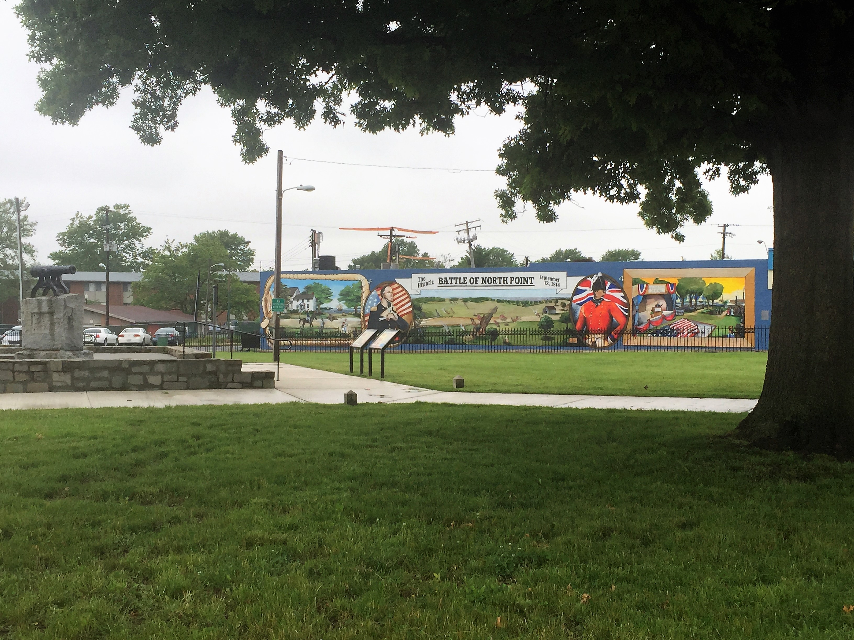
Battle Acre Park is a 1-acre site with lush greenery dedicated to the Battle of North Point during the War of 1812. The site features a large mural and a small stone canyon.
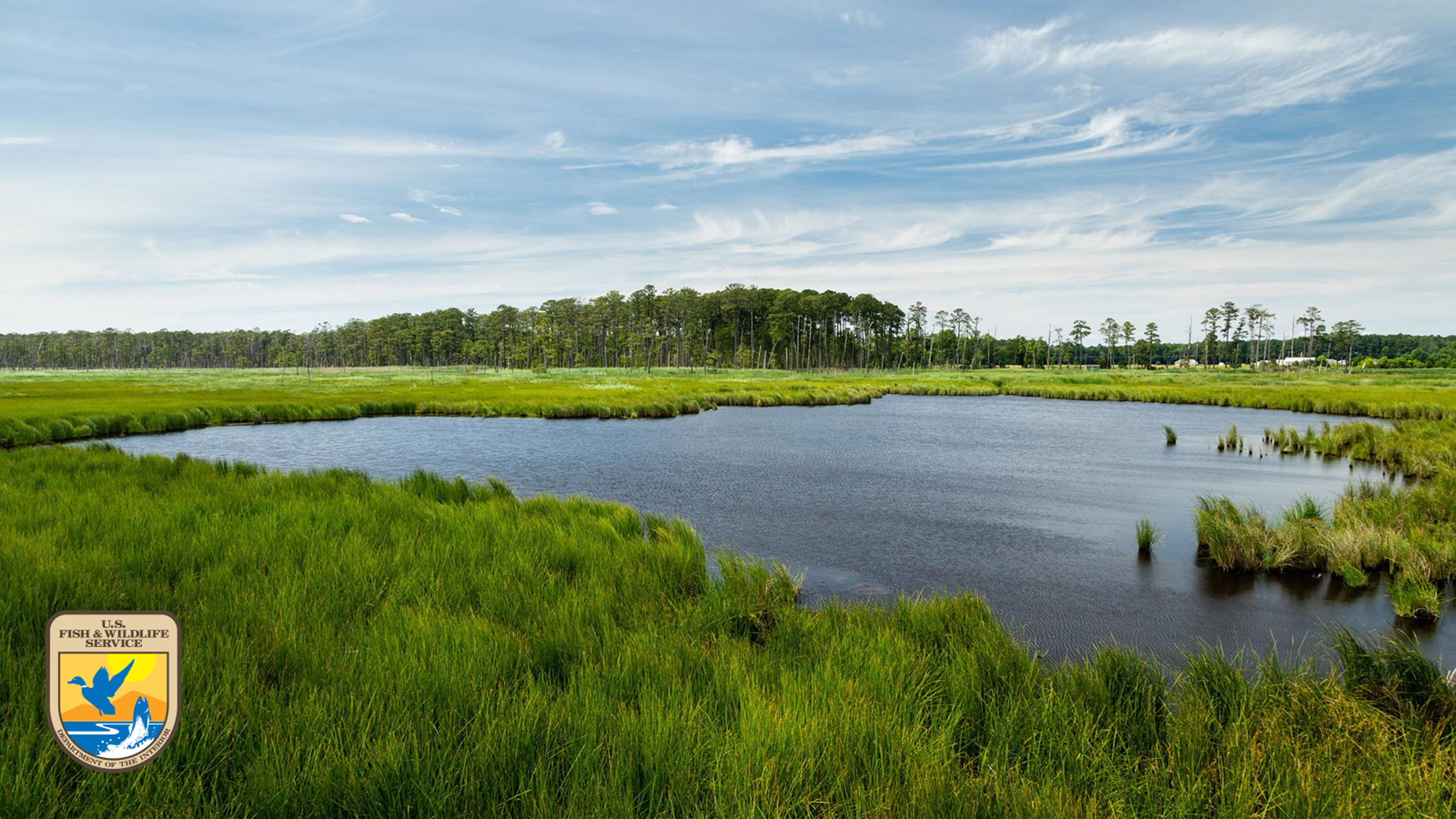
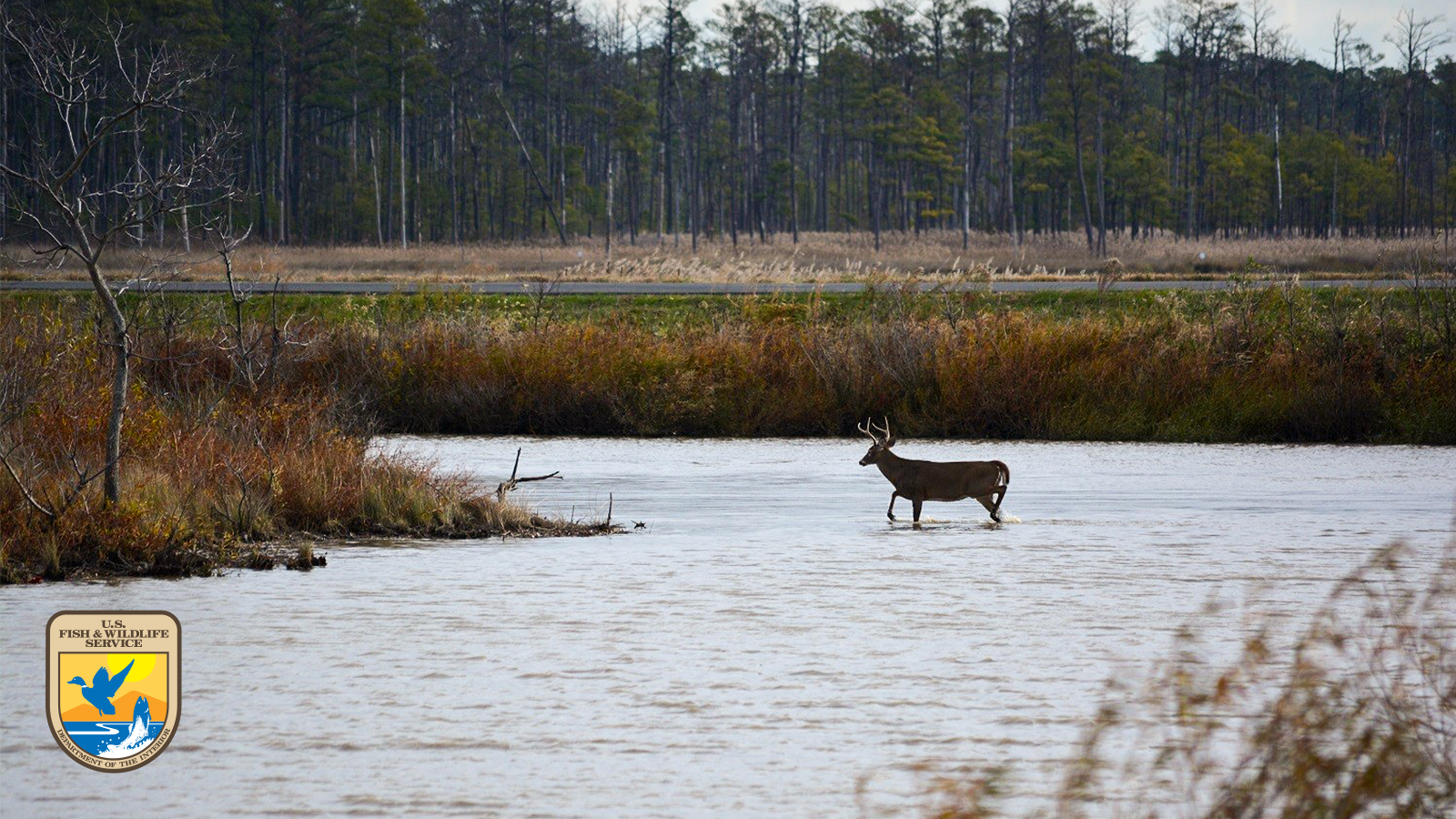
This U.S. Fish and Wildlife Service refuge protects vital Chesapeake Bay wetlands for migratory birds and native wildlife. A Chesapeake Gateways Network Site, Blackwater offers hiking, paddling, birdwatching, and engaging exhibits on wildlife, stewardship, and regional heritage.
The image features a serene landscape of a wetland area. In the foreground, lush, vibrant green grasses surround a tranquil body of water, which appears dark and reflective. The wetland extends into the middle of the image, bordered by more tall grass. In the background, a dense tree line of tall, slender trees creates a natural boundary, their dark green leaves contrasting with the bright greenery below. Above, the sky is expansive, painted with wispy, white clouds against a pale blue backdrop, adding to the peaceful and open atmosphere of the scene.
163 Duke of Gloucester is the home John Maynard an African American community leader and a founding trustee of the Stanton School in 1865, which was the first free school for African American children in Annapolis. 148 Duke of Gloucester Street was the home of William Butler, Sr., an African American builder and prosperous landowner who was one of the wealthiest people in the city at the time of the US Civil War. He served on the Annapolis City Council from 1873 to 1875.
Duke of Gloucester Street runs from Church Circle southeast toward the Eastport Bridge. It is a two lane, one-way road with residential, commercial, and municipal properties on both sides of the road. On the corner of Duke of Gloucester and Market Street, to the right of a large red brick building with a concrete archway, is a detached house with white siding and a small staircase leading to a door. The house is historic, and fits in the rest of the street, which has many other historic buildings or buildings designed to look historic. The staircase up to the door is on the right side of the house, and there are two rows of three windows with an extra window on the upper row above the door. There are two dormer windows extending from the darker shingle roofline. Across the street is a three story brick building with impressive windows and a decorative white cornice. A staircase with an iron railing leads to a light green door on the right side of the building.
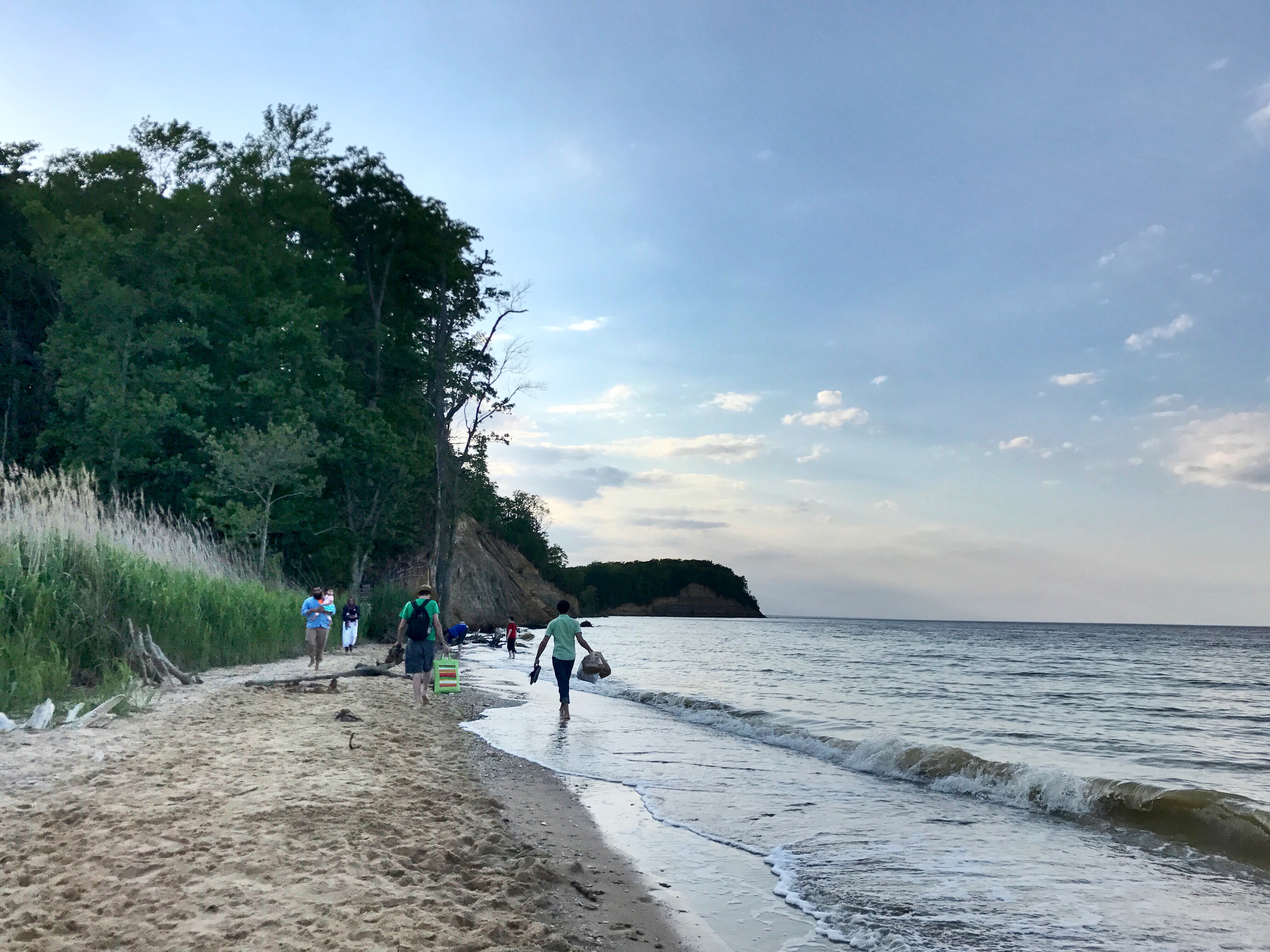
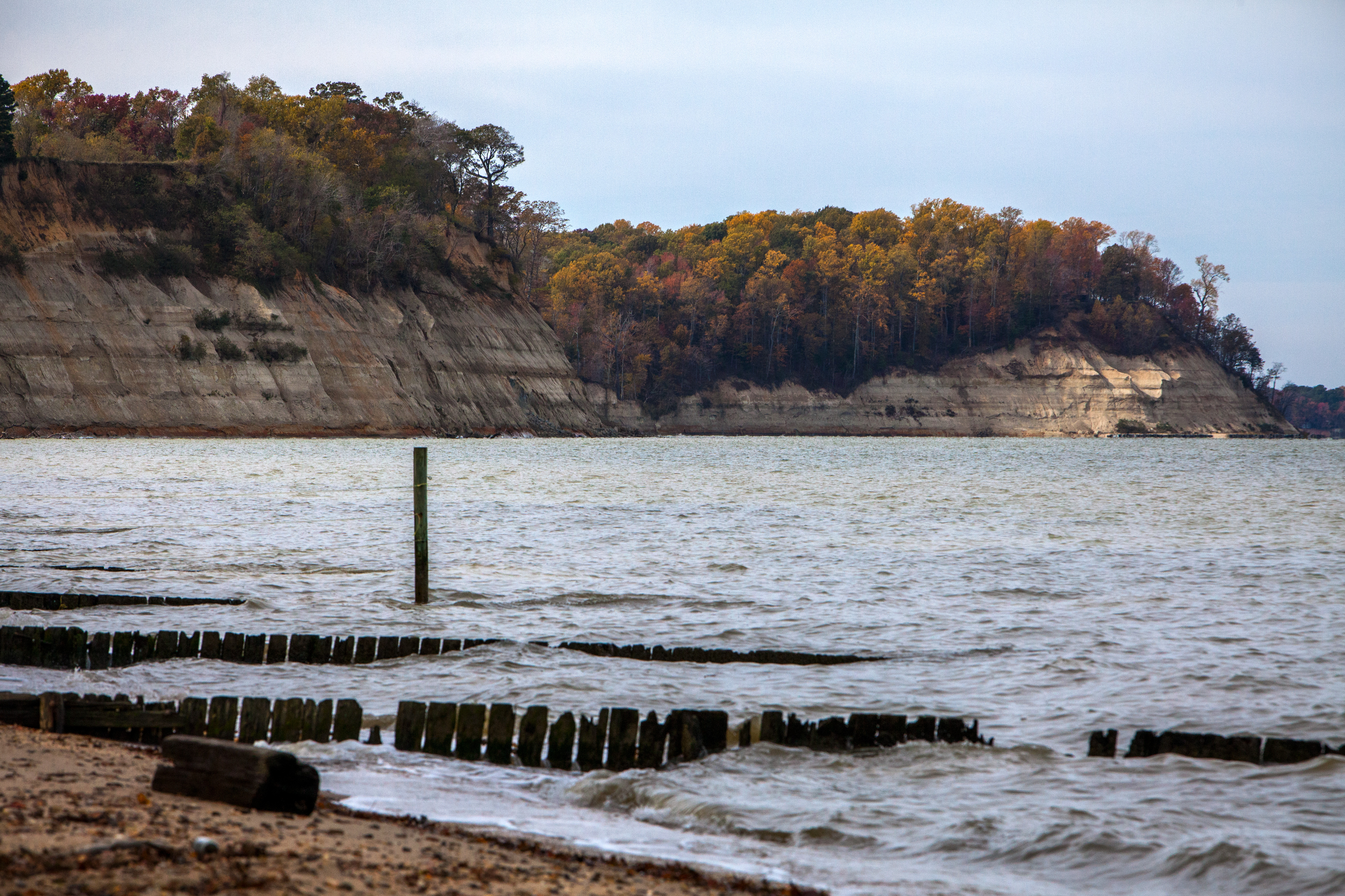
Calvert Cliffs State Park is a day-use park featuring a sandy beach, unique fossils, recycled tire playground, a freshwater and tidal marshland and 13 miles of hiking trails located in Calvert County.
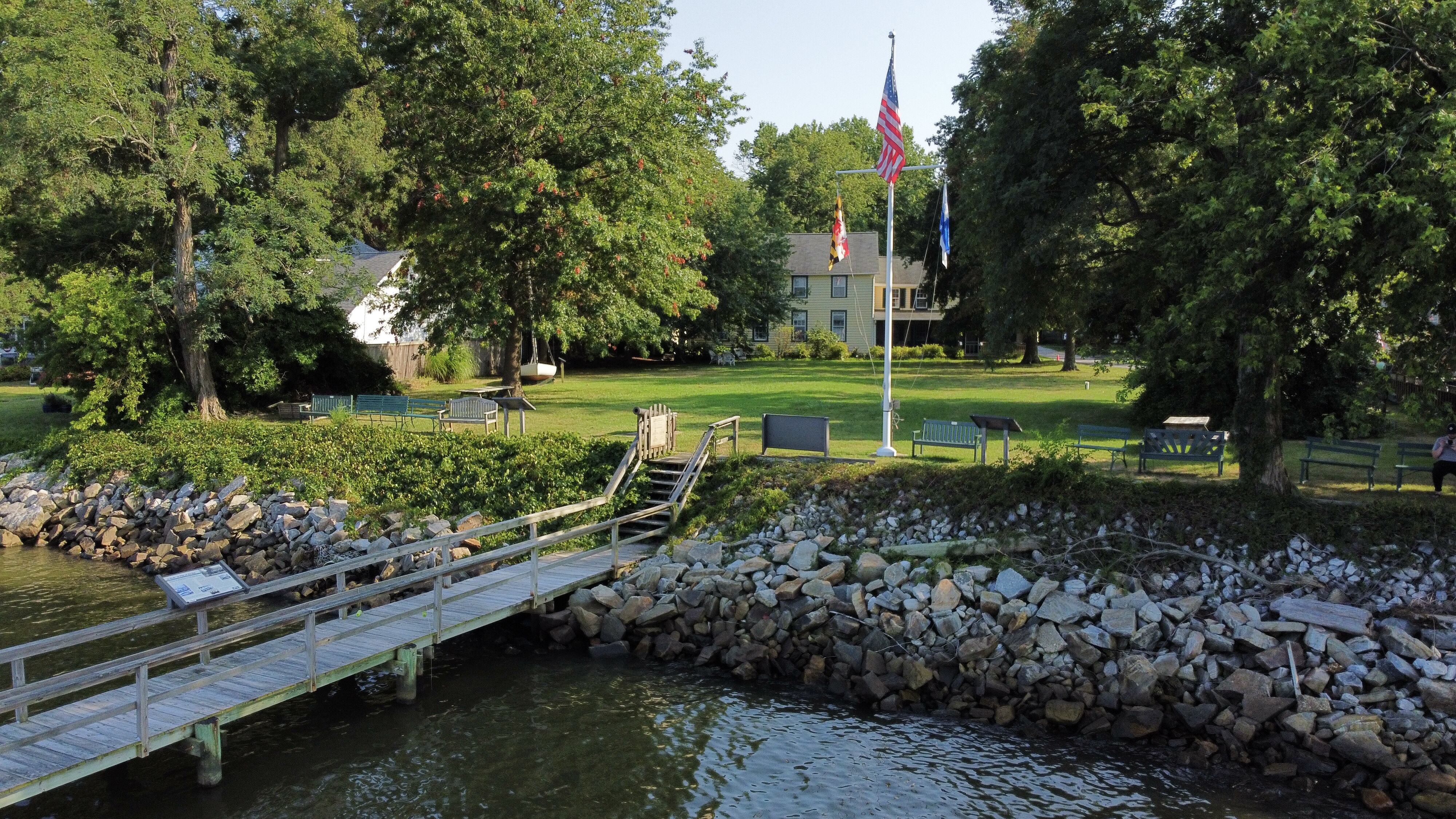
Explore the Captain Avery Museum’s historic home, shoreline trails, native gardens, and Chesapeake Bay exhibits. Learn about maritime traditions, segregation-era resilience, environmental stewardship, and ongoing restoration efforts. Enjoy live events, art programs, and family-friendly activities at this waterfront site honoring Chesapeake Bay heritage.
The image shows a serene outdoor setting by a waterfront. In the foreground, there is a wooden dock extending over the water, connecting to a grassy area. The water's edge is lined with a mix of large and small stones forming a rocky barrier. In the middle ground, there are several benches made of wood or metal, placed around a grassy lawn. A flagpole stands prominently, displaying three flags: the American flag, a Maryland state flag, and another unidentified flag. Behind the lawn is a house with beige siding and green shuttered windows, partially obscured by large trees with dense green foliage scattered throughout the setting. The scene is illuminated by bright sunlight, suggesting it is daytime.
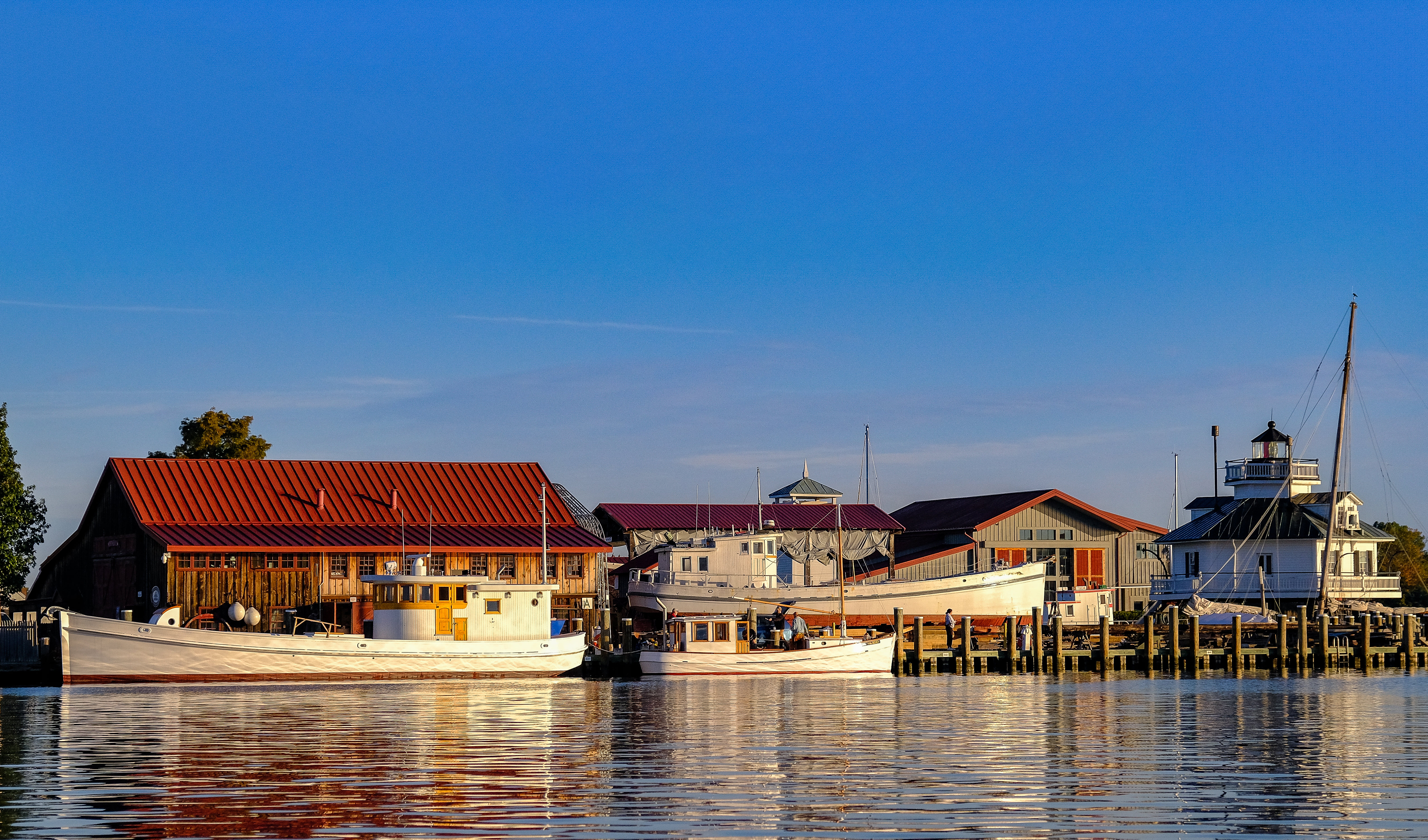
Experience the Chesapeake Bay Maritime Museum and discover historic boats, engaging exhibits, and all-ages programming that celebrate the Bay's history, environment, & culture. Watch skilled craftsmen in the working shipyard and enjoy scenic waterfront views. Located in St. Michael’s, this captivating destination invites you to explore the Chesapeake story through hands-on learning, world-class exhibitions, & on-the-water experiences. Your Chesapeake adventure begins here.
The image depicts a picturesque view of the Chesapeake Bay Maritime Museum. In the foreground, there are three boats docked at a wooden pier, their reflections shimmering in the calm water. The boat closest to the left is predominantly white with a wooden deck. Behind the boats are a series of buildings, beginning with a wooden structure with a prominent red roof on the left. This building has large windows and a rustic appearance. To its right, another building with a darker red roof can be seen, partially obscured by the boats. Further right, a small, white lighthouse structure with a black roof stands out, featuring a round, elevated balcony and a flagpole. The sky above is clear and blue, suggesting a sunny day.
Chippokes State Park is one of the oldest continually farmed plantations in the US and explores and shares the history of its enslaved population on the site through programs, exhibits and a memorial.
Chippokes State Park is a very large park with many fields, grasslands and gardens spread throughout its 1,947 acres. The park runs along the James River and has many sandy beaches.
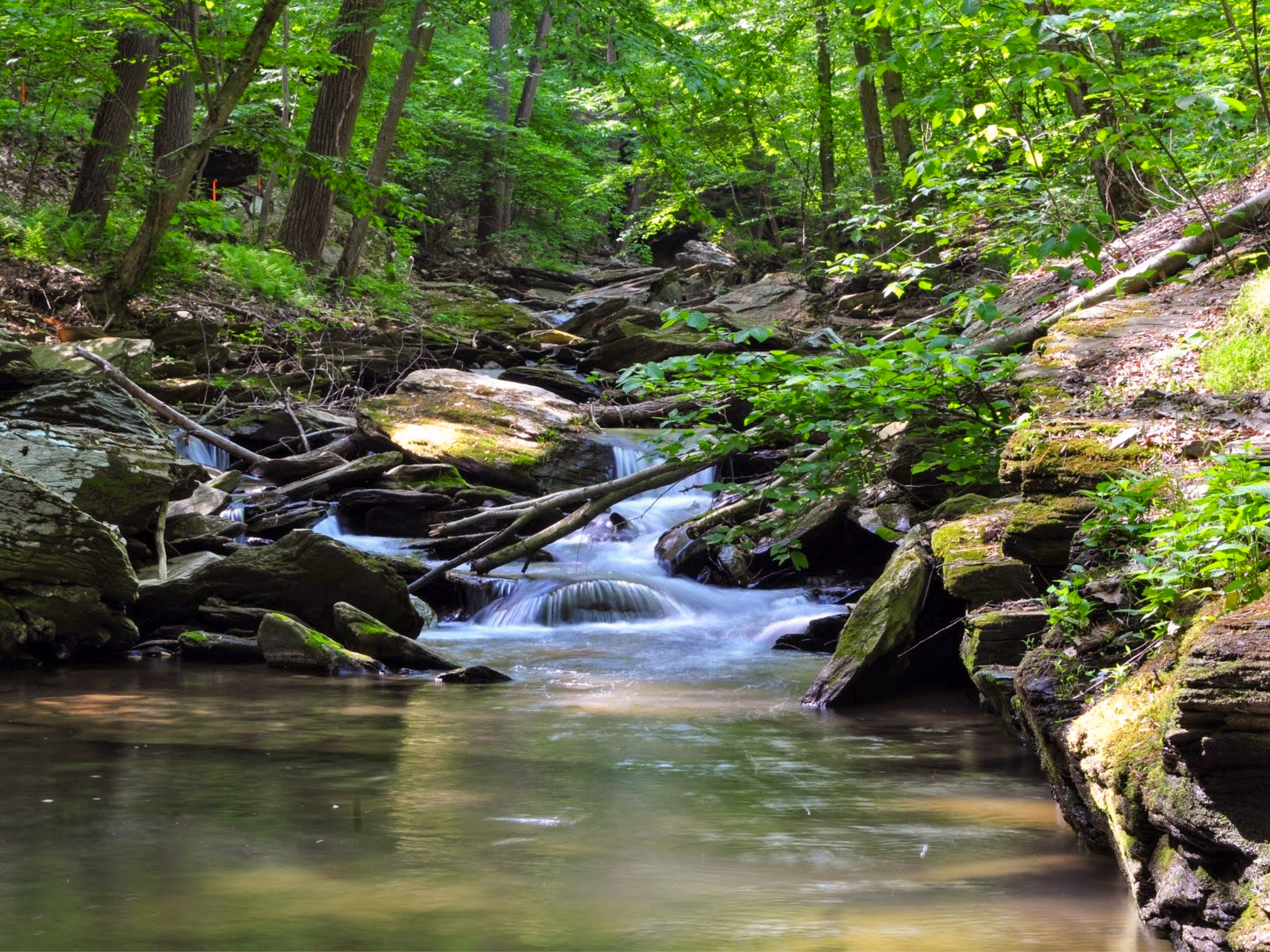
Explore rare forests, trout streams, and meadows at Climbers Run Nature Center. Hike scenic trails, observe unique wildlife, and discover how active land stewardship supports Chesapeake Bay health. This site offers hands-on learning, public events, and a chance to experience conservation in action.
The image depicts a serene forest scene with a small stream flowing over rocks. The water is clear, cascading gently over smooth stones, creating a series of small waterfalls. The stream is surrounded by an abundance of lush greenery, including tall trees and dense foliage, with sunlight filtering through the leaves, creating dappled lighting on the forest floor. Fallen branches and logs are scattered along the water, adding to the natural landscape. The rocks are covered in moss, emphasizing the lush, verdant environment.
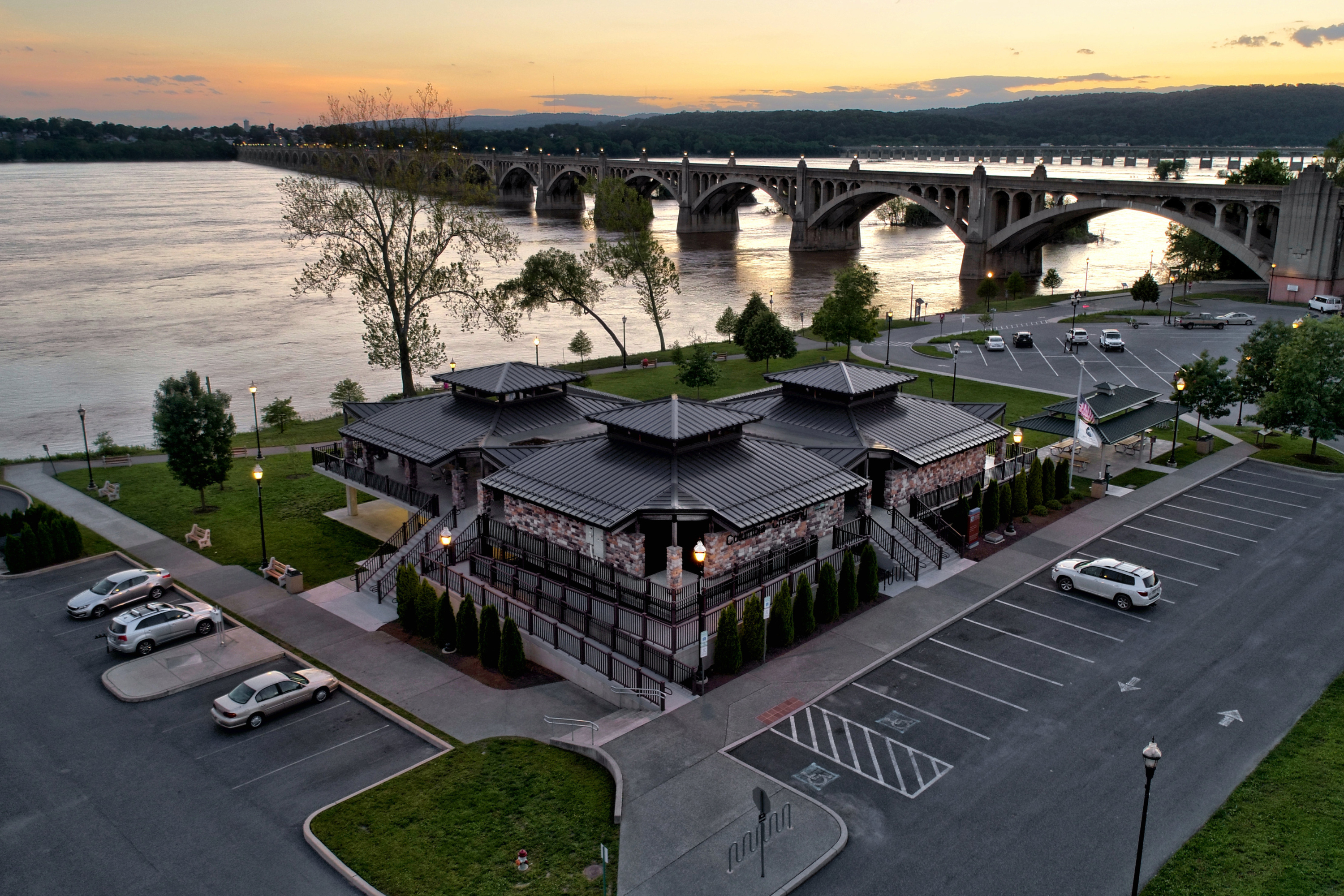
Discover Columbia Crossing River Trails Center, where the Susquehanna River’s history, culture, and natural beauty come alive. Explore exhibits, learn about river commerce, conservation, and freedom seekers, launch boats and paddle craft from Columbia River Park, and enjoy scenic views from the Riverview Deck. Access nearby land and water trails and connect with the vibrant stories that have shaped this vital river corridor.
The image captures an aerial view of a building complex with a modern design, featuring multiple small structures with dark, sloping roofs. The buildings are surrounded by a neatly landscaped area with grass, trees, and lampposts. The complex is adjacent to a large river, over which an arch bridge stretches into the distance. The bridge is illuminated with lights, leading to a hilly area with trees on the opposite bank. A parking lot surrounds the building, containing several parked cars. The setting appears to be at sunset, with soft, warm colors in the sky reflected on the water.
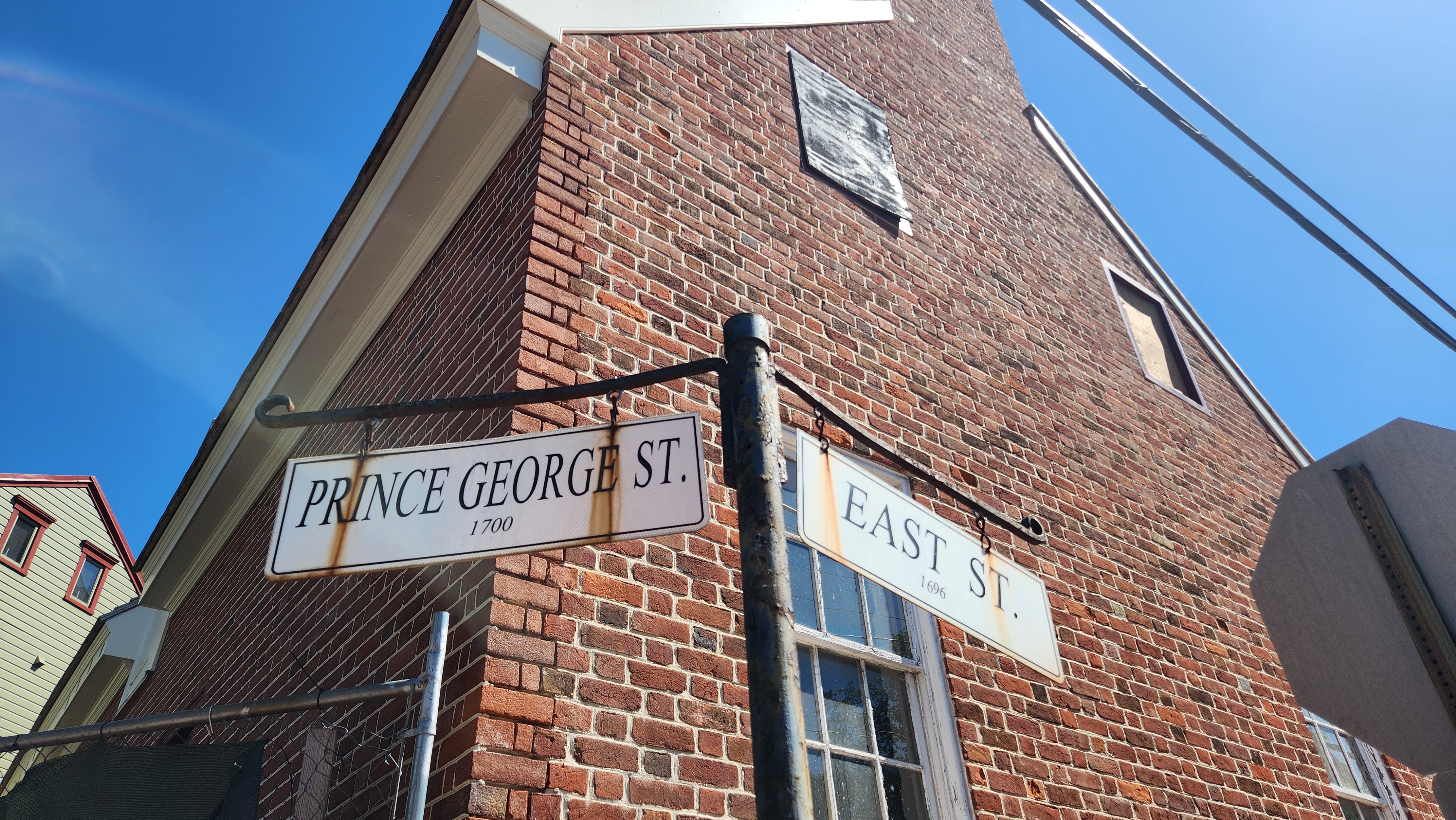
History is all around you where East Street and Prince George Street meet. The James Brice House is an example of 18th century Georgian architecture. The church across the street, now modern housing, was built as a mission chapel for St. Anne’s Episcopal Church and then served as a synagogue from 1919 through 1962. To the church’s right, this small home, the Creagh-Smith House, was built by colonial craftsman Patrick Creagh and later owned by two free African Americans.
Prince George Street runs southeast and meets East Street, which runs east to west, at a large intersection. Most of the buildings on the corners of these streets are homes, although some historic homes have been turned into museums. On the northern corner is a large five-part Georgian mansion built of brick that was the home of a prominent Annapolitan of colonial and revolutionary days, James Brice. The other homes along the street retain period features including wooden siding, wrought iron gates, and brickwork. There are trees intermittently along both roads, and the brick of the pavement is uneven in places.
Explore Chesapeake Bay history at the Deltaville Maritime Museum through exhibits on wooden boatbuilding, oyster restoration, living shorelines, and hands-on boatbuilding experiences. Connect with the Bay’s maritime culture and environmental heritage along the Captain John Smith Chesapeake National Historic Trail.
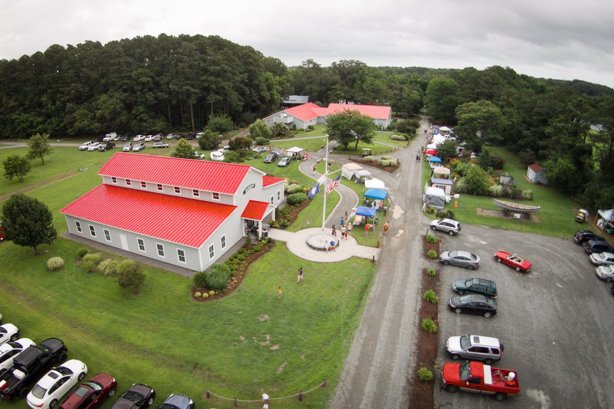
The image depicts an aerial view of a rural community center with a prominent building in the foreground. The building is rectangular with a light gray exterior and a bright red roof. Nearby, a small group of people gathers around a flagpole featuring multiple flags. A winding path lined with planted shrubs and trees leads from the building to an area with several tents or stalls set up under canopies. Beyond the main building, more structures with red roofs are visible, surrounded by lush, green landscaping and trees. A gravel parking lot on the right side of the image contains several vehicles, while additional cars are parked on grass to the left. Dense forest encircles the area in the background, under an overcast sky.
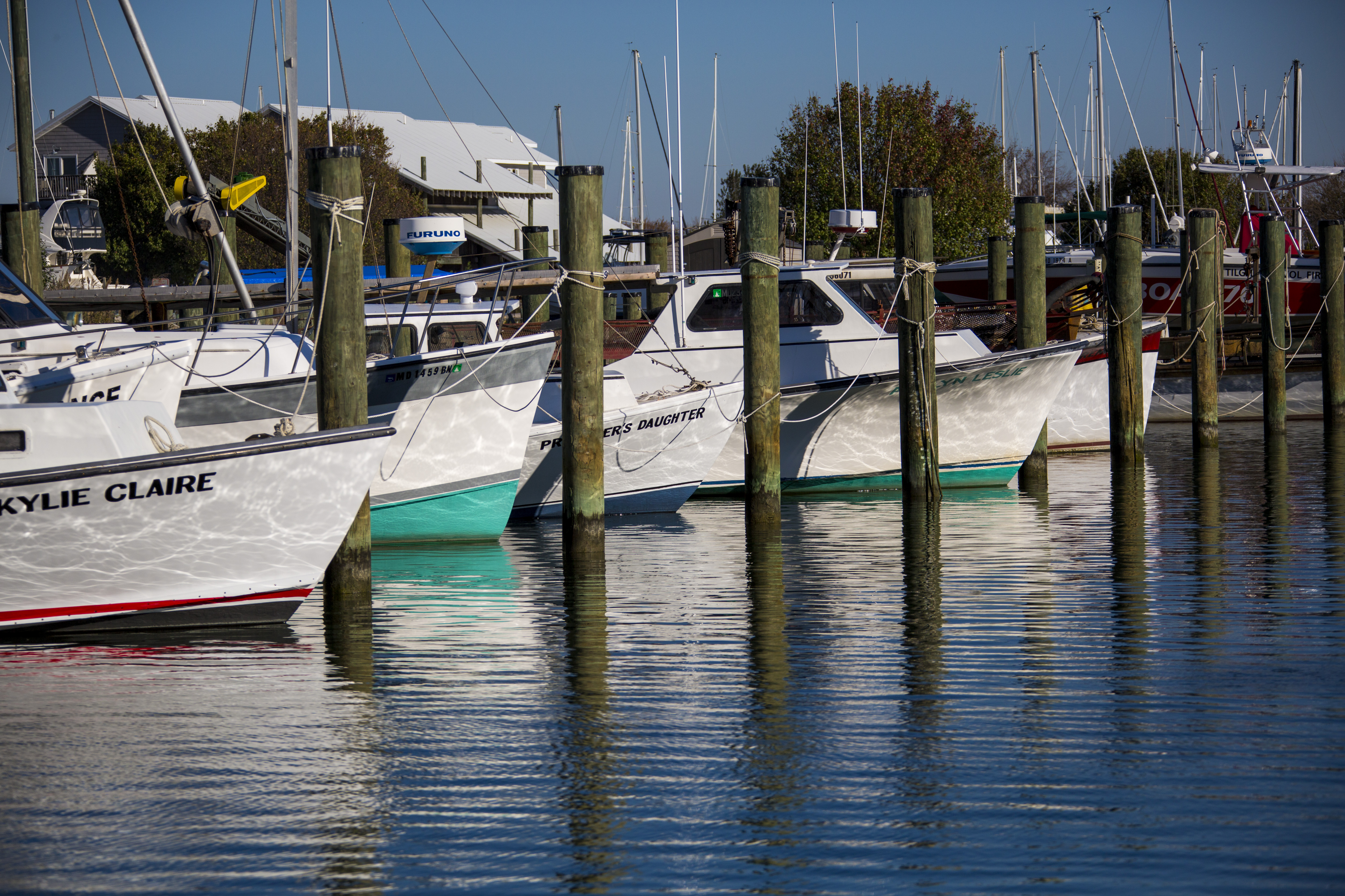
Discover a true working harbor on Tilghman Island where historic skipjacks and watermen still ply the waters. Dogwood Harbor offers public water access, scenic views, and insight into the Chesapeake Bay’s maritime traditions through interpretive signage and living history.
The image depicts a serene marina scene with several white fishing boats docked along wooden piers. The boats are aligned parallel to one another, with their bows facing right. On the left side of the image, one boat is named “KYLIE CLAIRE” with a red stripe along the hull. Another visible boat name is “FURUNO.” The water is calm, reflecting the boats and the piers, creating ripples and patterns. In the background, there are assorted wooden and metal structures, along with a few trees and a white building with a gray roof. The sky is clear and blue, indicating a sunny day.
This U.S. Fish and Wildlife Service refuge protects Chesapeake Bay island habitats for birds and native wildlife. A Chesapeake Gateways Network Site, Eastern Neck offers trails, fishing, hunting, and exhibits on the island’s rich ecological and cultural history.
A serene landscape featuring a deer standing in a shallow body of water. The animal is positioned slightly to the right of the center, with its body oriented to the left. The deer is partially submerged as it wades through the water. Surrounding the water are tall, brown grasses and sparse, leafless trees, indicating a late autumn or early winter setting. In the background, a dense line of dark green trees forms a natural barrier, contrasting with the lighter sky above. The overall scene conveys a calm, natural environment.
The Essex County Museum tells the story of the Rappahannock River and Essex County’s rich history. Explore exhibits on early American exploration, the Revolutionary War, local river traditions, and the Pirates of the Chesapeake. See a scale model of Fort Lowry, boat models, and a 16-foot pictorial map of the river. Visitors can also enjoy the charming courtyard with a NASA Moon Tree and find unique artifacts from the steamboat era.
The image depicts a brick building housing the Essex County Museum & Historical Society. The structure features classic red brickwork with white-trimmed windows. A prominent sign hangs on a metal bracket, displaying the museum's name. Below the sign, a colorful flag with circular patterns is attached to the building. Green awnings labeled "MUSEUM" hang over the entrance and windows, providing contrast against the brick facade. Metal benches and potted plants line the sidewalk, enhancing the historic charm. A sandwich board on the sidewalk announces that the museum and gift shop are open.
English colonists who crossed the Atlantic Ocean in 1607 arrived at the spot now commemorated as First Landing State Park. They would travel further upriver before choosing to build the settlement they called Jamestown. First Landing State Park is in Virginia Beach, VA and is the state’s most visited park. The 2,888-acre park offers camping, picnicking, swimming, boating and more along the Chesapeake Bay. 2500 Shore Dr, Virginia Beach, VA 23451 757-412-2300
First Landing State Park is a large waterfront park in Virginia that runs along the Chesapeake Bay and offers picnicking, camping, hiking, swimming and more.
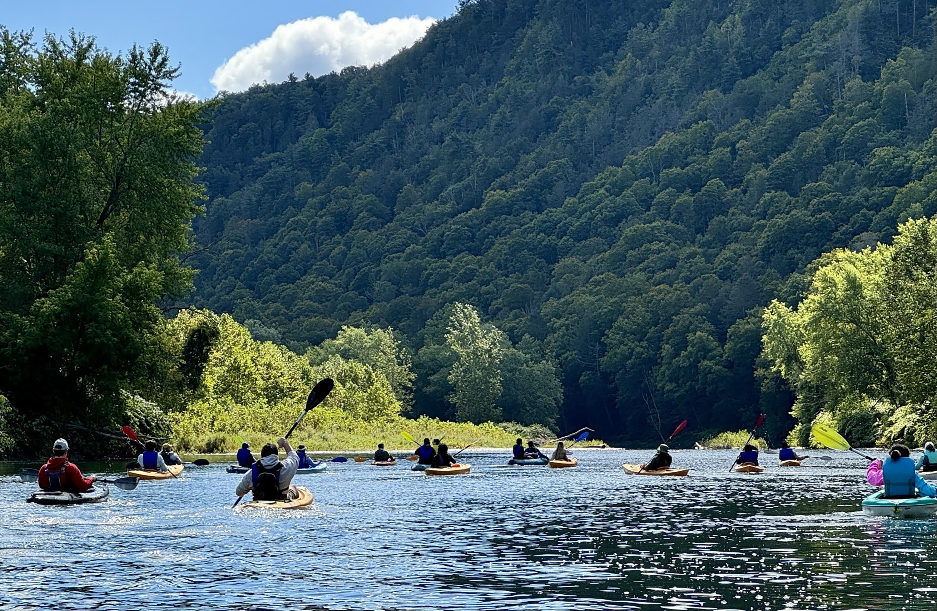
Discover the Friends of the Chemung River Watershed, a Chesapeake Gateways Network Site where history and nature meet! Explore exhibits showcasing the river’s rich cultural and ecological significance, then paddle, fish, or hike scenic trails teeming with wildlife. Whether seeking adventure or a peaceful retreat, the Chemung River offers something for everyone. Come explore, learn, and protect this natural treasure!
The image depicts a scenic view of a group of kayakers paddling along a river, surrounded by lush green trees and a densely forested hillside. The kayakers, wearing various-colored jackets and life vests, are moving away from the camera, creating a sense of direction and movement toward the background. The river's surface reflects the sunlight, creating shimmering patterns. On the left, tall trees line the riverbank, and on the right, dense foliage is visible. The background features a towering, tree-covered hill under a partly cloudy blue sky.
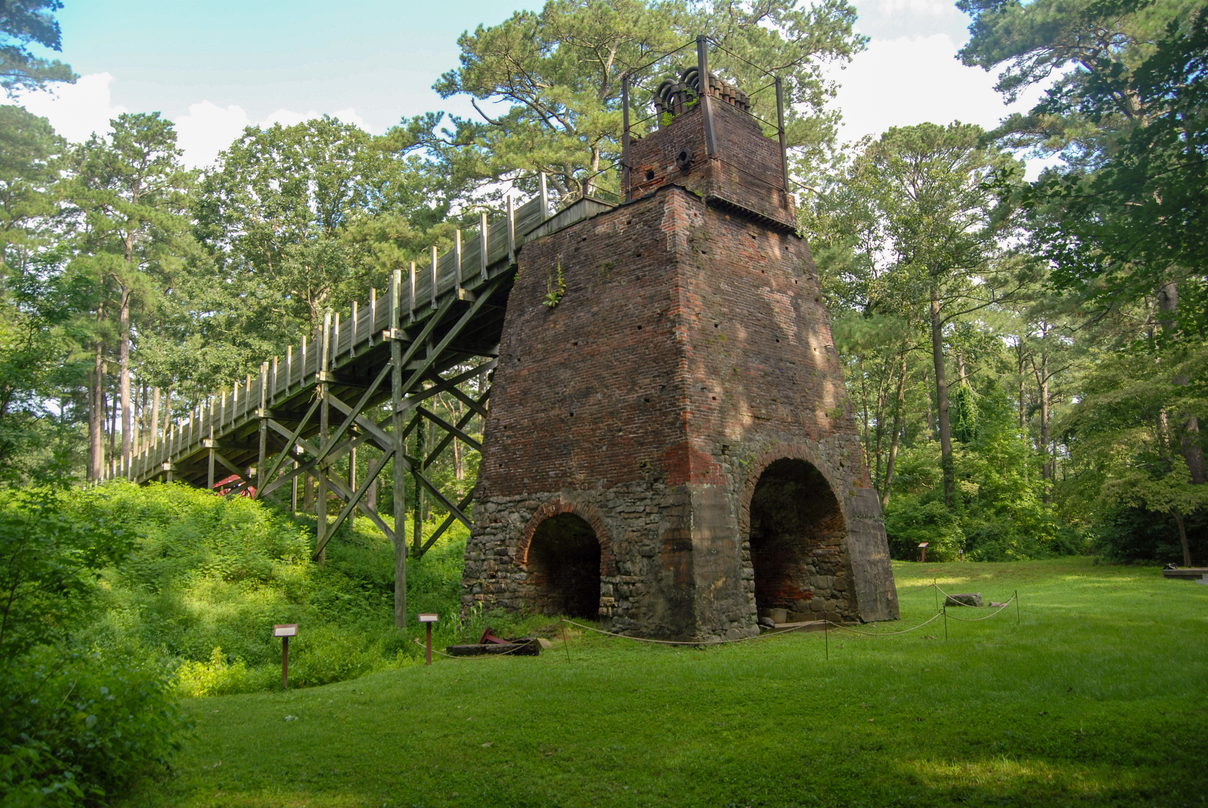
Explore Furnace Town Historic Site’s living history village, nature trails, and artisan workshops. Discover Chesapeake Bay watershed stories of ironworking, environmental impact, Indigenous presence, and cultural traditions. Enjoy family activities, seasonal festivals, and hands-on experiences that connect visitors to the region’s industrial and natural heritage.
The image features an old, brick and stone furnace structure in a wooded area. The furnace is pyramidal in shape, with a wide base and narrower top, displaying two large arches at the bottom. A connected structure is visible on the left, consisting of a long wooden walkway supported by a series of vertical wooden posts. This leads up to the top of the furnace. The surrounding green grass and dense foliage of tall trees create a lush natural environment. The scene is well-lit by daylight, casting shadows on the ground and highlighting the texture of the brickwork.
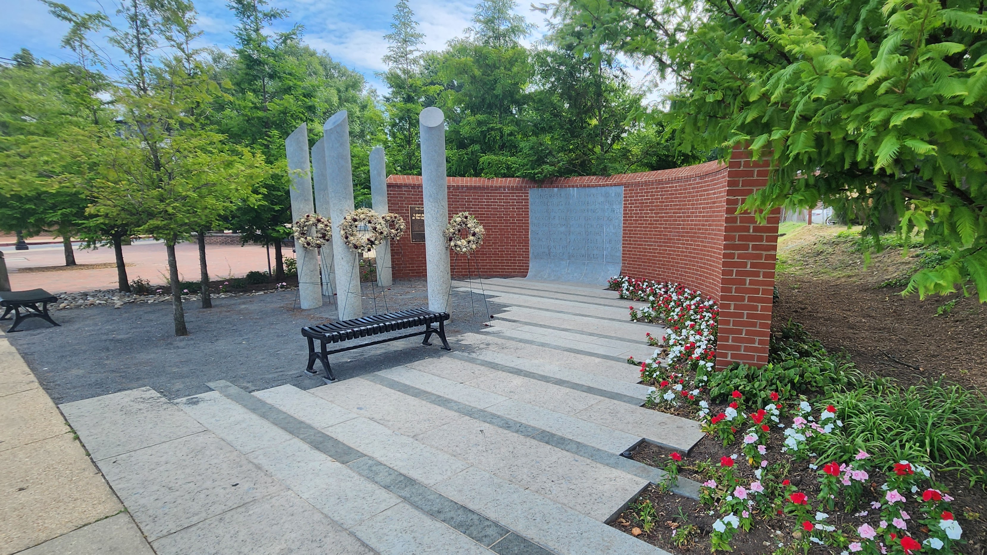
The Guardians of the First Amendment Memorial honors those who lost their lives in the 2018 Capital Gazette mass shooting and represents the journalism community’s commitment to uphold the basic rights enshrined in the U.S. Constitution.
A brick wall curves around a small park on the side of Compromise Street, which runs along the water from the Eastport Bridge up to Main Street and Ego Alley. The park is paved with a few benches and small trees. The main focuses of the small park are stone columns and a large piece of stone inlaid in the brick wall with a quote carved into it.
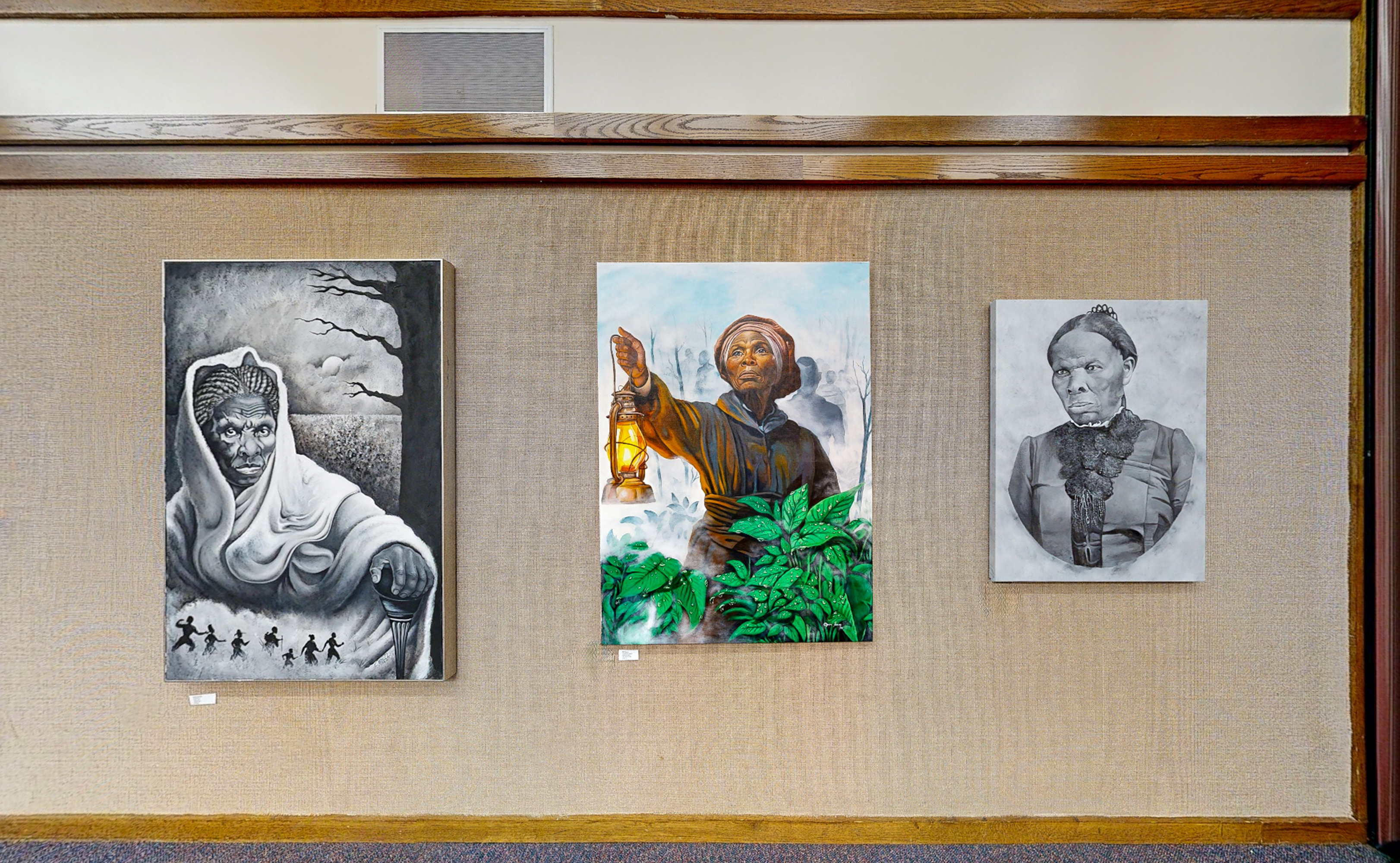
Experience the Chesapeake landscapes that shaped Harriet Tubman’s journey to freedom. The Harriet Tubman Center for Cultural and Educational Advancement offers powerful storytelling, education, and connection to the enduring legacy of the Underground Railroad and the Bay’s natural and cultural heritage.
The image displays three paintings of Harriet Tubman hung on a beige, textured wall with wooden trim at the Harriet Tubman Center for Cultural and Educational Advancement. The left painting is a black-and-white depiction of Tubman, draped in a shawl, with an intense gaze. Below her, small silhouettes of people are shown running, suggesting a scene related to the Underground Railroad. The central painting is a colorful representation of Tubman holding a lantern in an outstretched arm, surrounded by lush green leaves and a misty background. This conveys a guiding and protective image. The right painting is an oval-framed black-and-white portrait of Tubman, showing her face with a focused expression, wearing a high-collared dress adorned with lace.
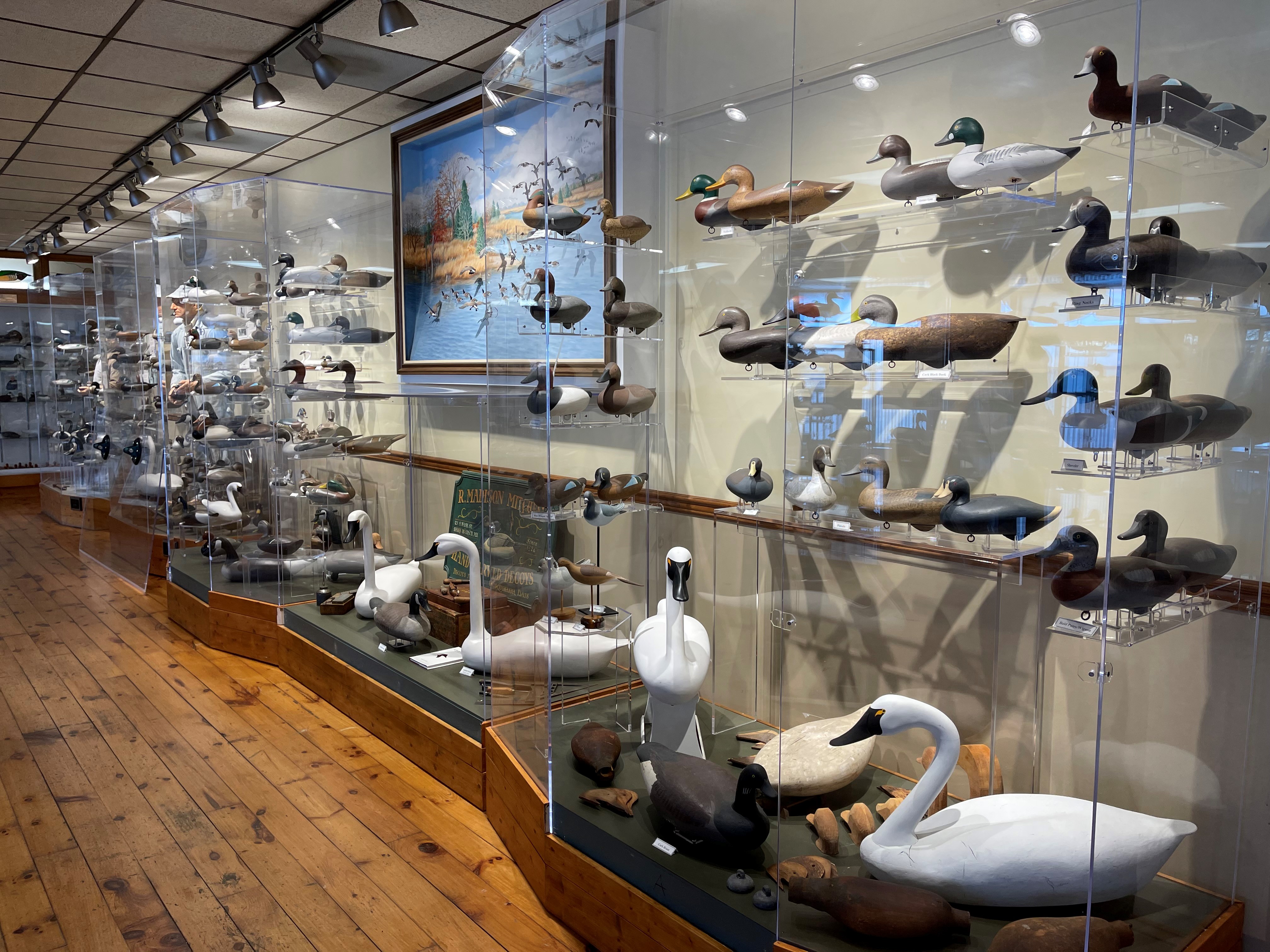
Discover Chesapeake Bay waterfowling heritage at the Havre de Grace Decoy Museum. Explore historic decoys, hunting boats, interactive exhibits, and artisan stories reflecting the cultural and ecological richness of the Susquehanna Flats. Learn how artistry, community traditions, and environmental stewardship shaped this historic Chesapeake landscape.
The image depicts a museum-style display of carved wooden duck decoys in a well-lit room with wooden flooring. The decoys are arranged on several glass shelves within transparent cases that run along the left side and the back of the room. Various types of ducks are shown, differing in color and size, mimicking real waterfowl. Some display realistic detailing, while others are more stylized. Towards the back, a large, framed painting of a lake with ducks is hung on the wall, adding a scenic backdrop to the display. The room has a wooden ceiling with track lighting focused on the display cases.
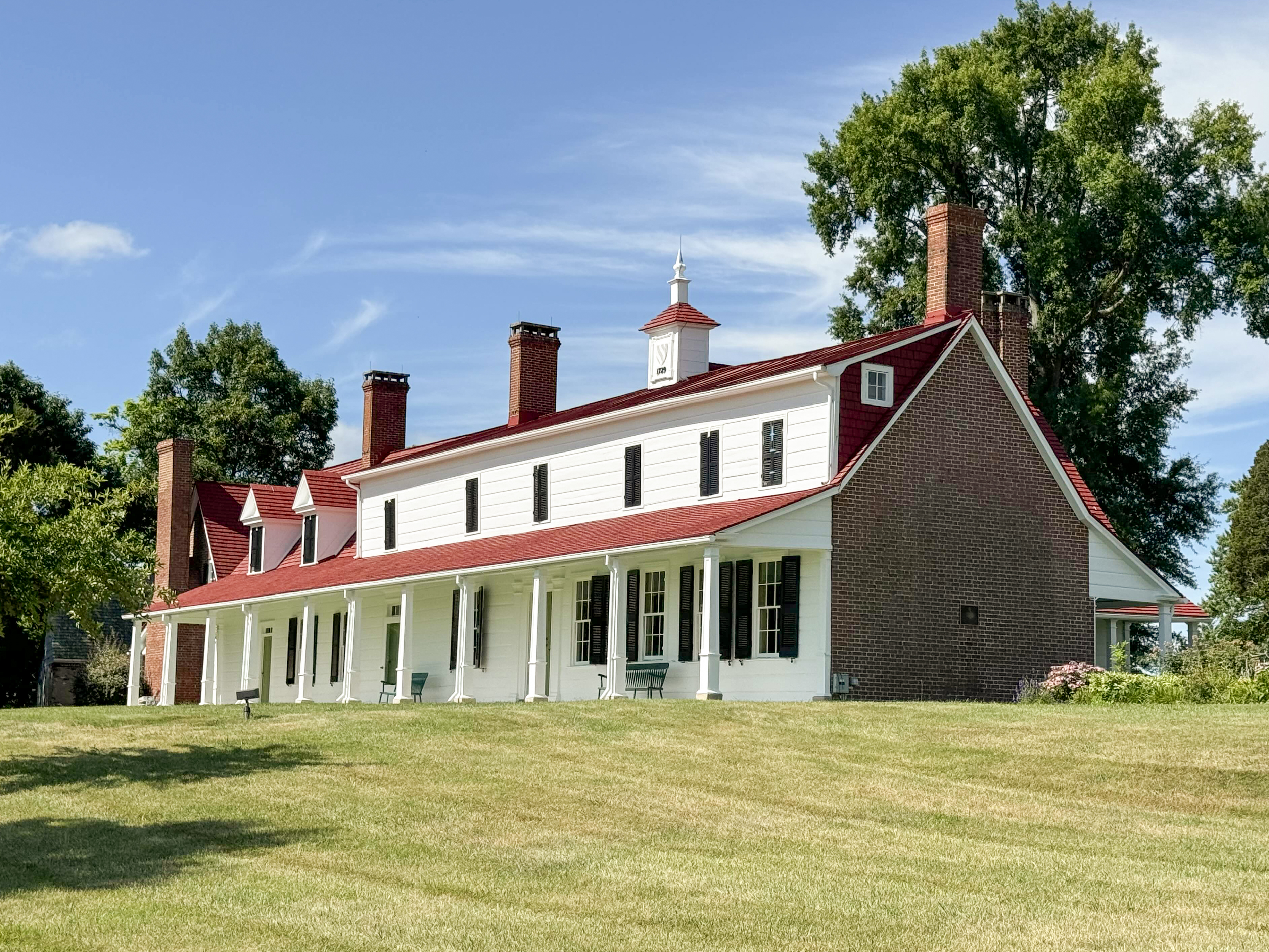
Historic Sotterley, a National Historic Landmark and UNESCO Site of Memory, preserves over 300 years of history, offering powerful stories of the past alongside scenic trails, gardens, and views of the Patuxent River.
The image displays a large, historical-style house situated on a well-maintained lawn under a clear blue sky. The building features a long, single-story structure with white wooden siding and a red gabled roof. There are multiple chimneys rising from the roof and black shutters on the windows. A cupola with a weathervane tops the center of the roof. Columns support the front porch that spans the length of the house. Surrounding the building, mature trees and shrubs add greenery, and sunlight casts soft shadows on the grass.
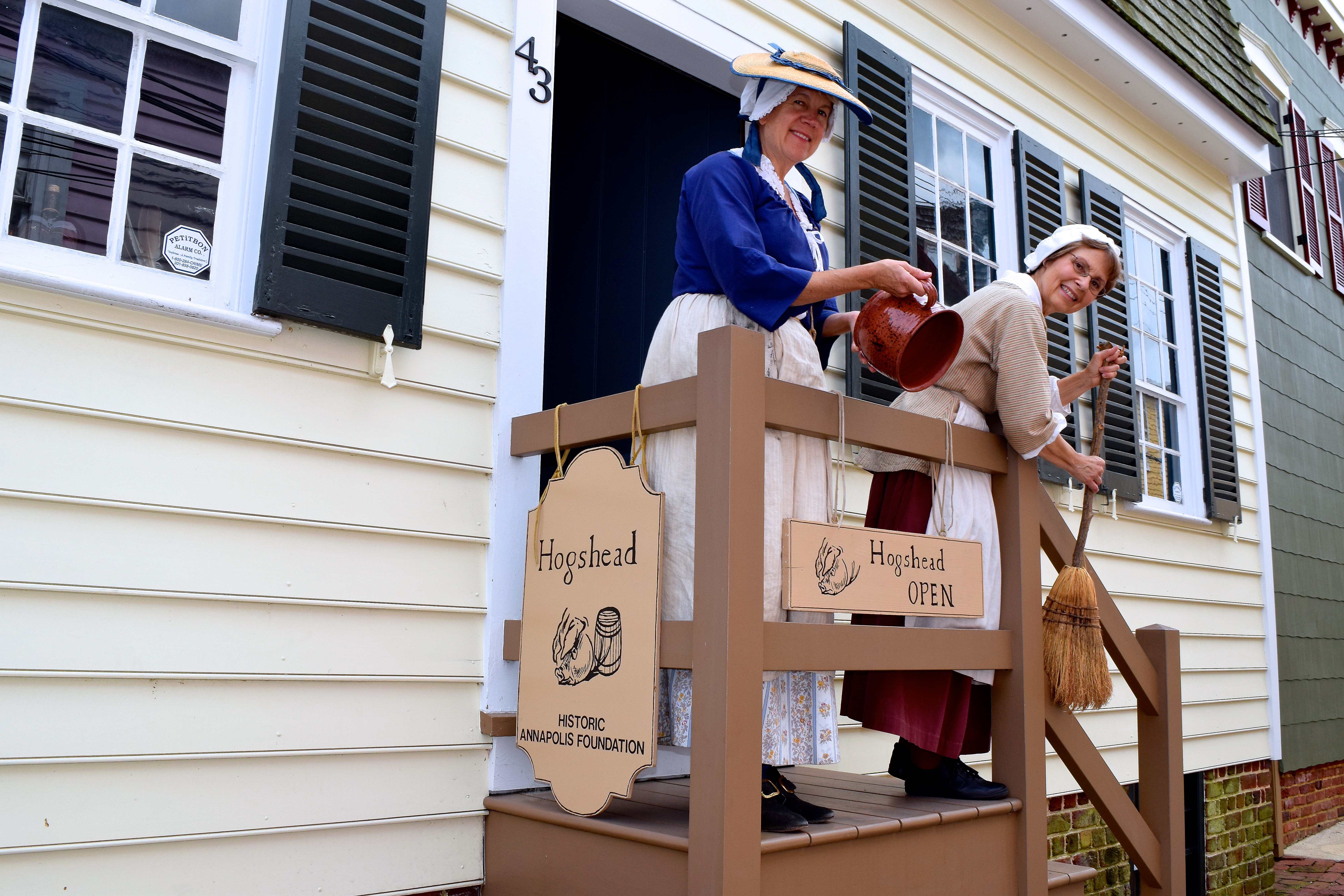
Step into the past at Hogshead, a rare surviving home of Annapolis’s 18th- and 19th-century working class. Costumed interpreters bring history to life, sharing stories of artisans, laborers, and free Black residents. Explore the home’s two floors, handle reproduction artifacts, and discover historic crafts and daily life. Experience the connections between Chesapeake Bay trade, industry, and the people who shaped Maryland’s capital.
The image shows two women dressed in historical attire on a small wooden porch with a railing in front of a beige clapboard building. The woman on the left wears a blue blouse, a white apron, and a hat, holding a ceramic jug. The woman on the right is in a beige blouse with a white cap, holding a broom. Signs are affixed to the railing: one reads "Hogshead" with an image of a hog and barrel, and "Historic Annapolis Foundation" below. Another sign says "Hogshead OPEN." The building's exterior features black shutters and multiple-paned windows. The number "43" is visible on the door frame.
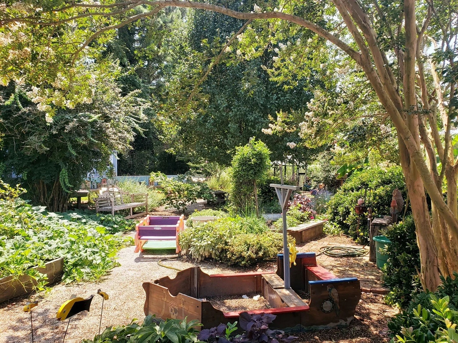
Experience gardens, trails, and waterfront recreation at Holly Point Nature Park. Enjoy kayak access, wildflower meadows, wildlife sculptures, and community events celebrating Chesapeake Bay traditions. Contact the Deltaville Maritime Museum or visit the website for event details and schedules.
The image shows a lush and vibrant garden bathed in sunlight. In the foreground, there is a small sandbox resembling a boat with a red edge and wooden sides. Surrounding the sandbox are various lush green plants, including low shrubs and flowering bushes. On the left, a garden bench made of wood is partially visible, situated under the shade of a large, leafy tree. Behind the bench, decorative birdhouses are lined up on a ledge. In the background, towering trees form a dense, green canopy. A narrow path meanders through the garden, bordered by plants and small flowering bushes. A garden hose is coiled neatly on the ground near the path, and a small whimsical statue is visible among the foliage on the right.
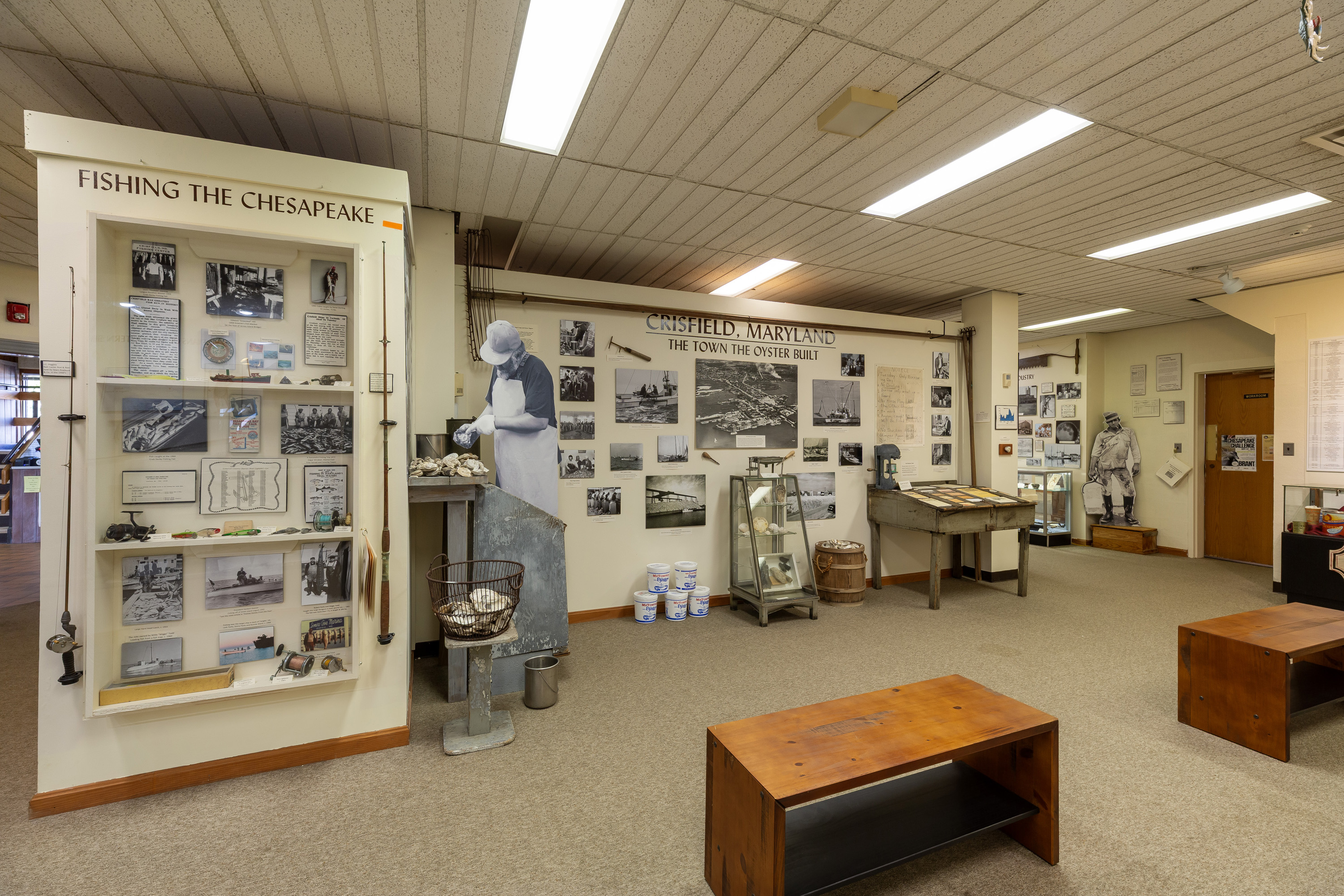
Explore the J. Millard Tawes Historical Museum and discover the story of Chesapeake Bay life. Exhibits feature Native American history, seafood industries, boat building, and decoy carving. Authentic photographs, artifacts, and changing displays reveal the rich cultural traditions of Crisfield and the wider Eastern Shore. Experience a living connection to the Bay’s enduring heritage.
The image shows an indoor exhibit at a museum featuring two main sections. On the left, there is an exhibit titled "Fishing the Chesapeake," which consists of a glass display case filled with historical photographs, documents, fishing rods, and various fishing-related artifacts. The display mount is off-white, providing a neutral backdrop. To the right, the "Crisfield, Maryland: The Town the Oyster Built" display covers a wall adorned with black-and-white photos, maps, and text panels about the oyster industry. A life-sized cutout of a worker shucking oysters stands beside an oyster shucking station, complete with tools and a basket of shells. The floor is carpeted, and overhead fluorescent lights illuminate the space. There are wooden benches placed for seating and viewing the exhibits.
Explore the forests, marshes, and wetlands at James River National Wildlife Refuge, where bald eagles soar, nature thrives, and history endures along the scenic James River in the Chesapeake Bay watershed.
The image depicts a serene autumn landscape featuring a tranquil lake bordered by trees in various stages of fall foliage. In the foreground, several trees with slender trunks and branches display a mix of orange, yellow, and bright green leaves, indicative of the seasonal transition. The lake in the midground reflects the clear blue sky above, creating a sense of calm. In the background, leafless trees stand against the sky, indicating a further progression into fall. The ground is covered with a layer of fallen leaves in shades of brown and orange.
The John Shaw House is one of the oldest standing houses in Annapolis, and was the home of notable cabinetmaker John Shaw after the Revolutionary War. This craftsman, more than any single person, was responsible for the appearance of the exterior and interior of the State House from the 1770s to the early nineteenth century. He cared for the grounds, illuminated the State House for festive occasions, supplied furnishings, made emergency repairs, and undertook maintenance.
At the south of State Circle, a small alley with stairs leads to Main Street in downtown Annapolis. Ringing the exterior circle of the road surrounding the state capitol are commercial properties in historic buildings. On the corner of the alley meeting the sidewalk is a large building made of red brick with wooden features painted white, a widow’s walk, and red roof.
Site of the home and printing shop of Jonas Green and his Dutch immigrant wife Anne Catharine Hoof Green who arrived in Annapolis in 1738. Both were ardent leaders of the movement for independence and served as printers and editors of The Maryland Gazette. With only two brief interruptions, in 1765 and during the Revolution, The Maryland Gazette ran under three generations of the Green family from 1745 until its ceased publication in 1839.
A white house with a dark shingled roof sits on the south side of Charles Street, a predominantly residential road with brick sidewalks and trees lining the walkway. The house has white siding but is partially made of brick, with five dormer windows extending from the upper roofline and a covered front entrance. The house, as well as many other houses along the street, retains period features from colonial Annapolis. There are power lines and streetlamps up and down the street as well, and the ends of the street aren’t visible through the tree coverage.
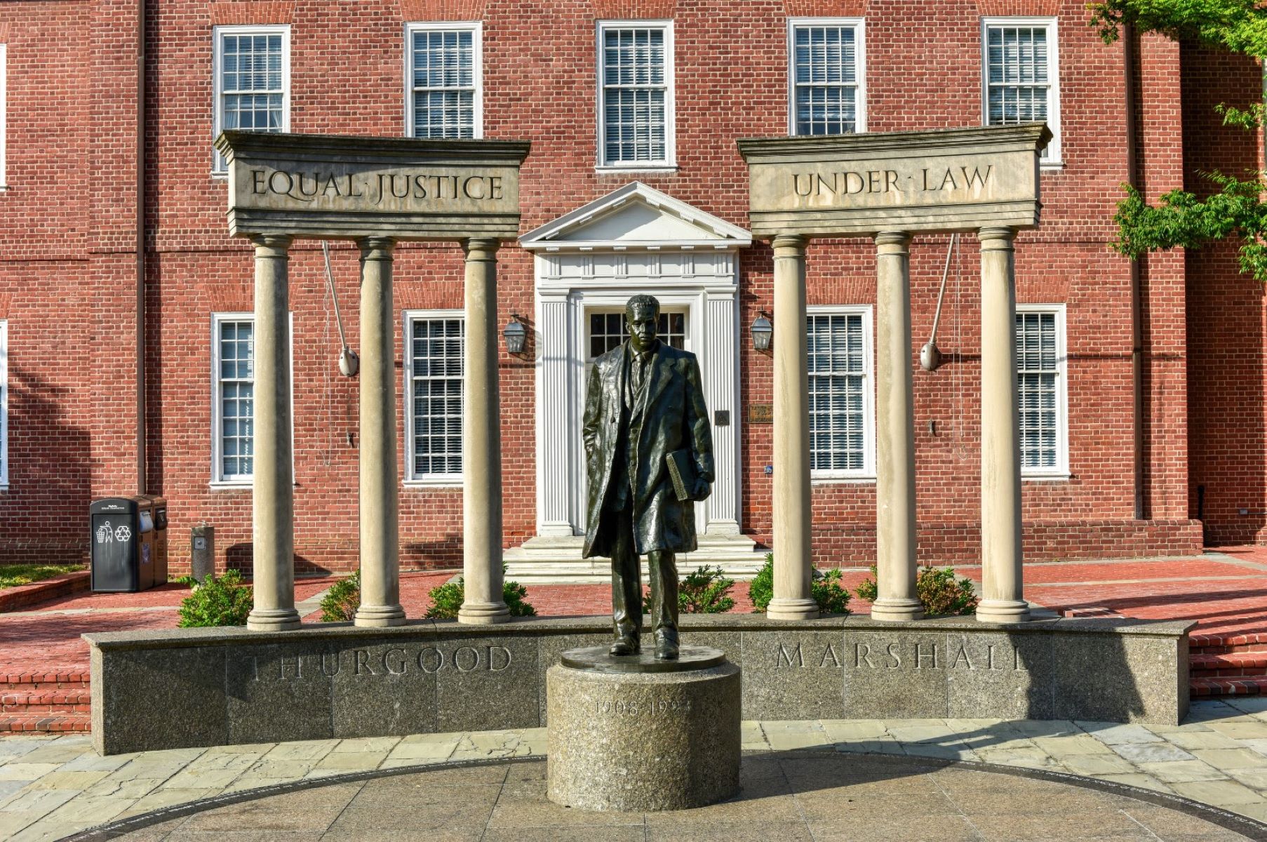
Lawyer’s Mall, at the base of the steps of the Maryland State House, can be considered as the gateway to Annapolis. This civic plaza serves as a public gathering space today, and features a memorial honoring the accomplishments of Supreme Court Justice Thurgood Marshall.
Lawyer’s Mall is a small brick and pavement area in between buildings used for legislative and administrative purposes by the Maryland State government. The Maryland State House dome is visible on the south west end of the mall, and Bladen Street is visible to the northwest. Roughly in the center of the mall are benches, and a statue on a plinth in front of two tri-column monuments. Around the plinth and statue is a circle of stone in a different color. The statue depicts Thurgood Marshall holding a book. On the other side of the small lowered area ringed by a brick half-wall and walkways are two statues of a boy and a girl looking up at the statue of Marshall.
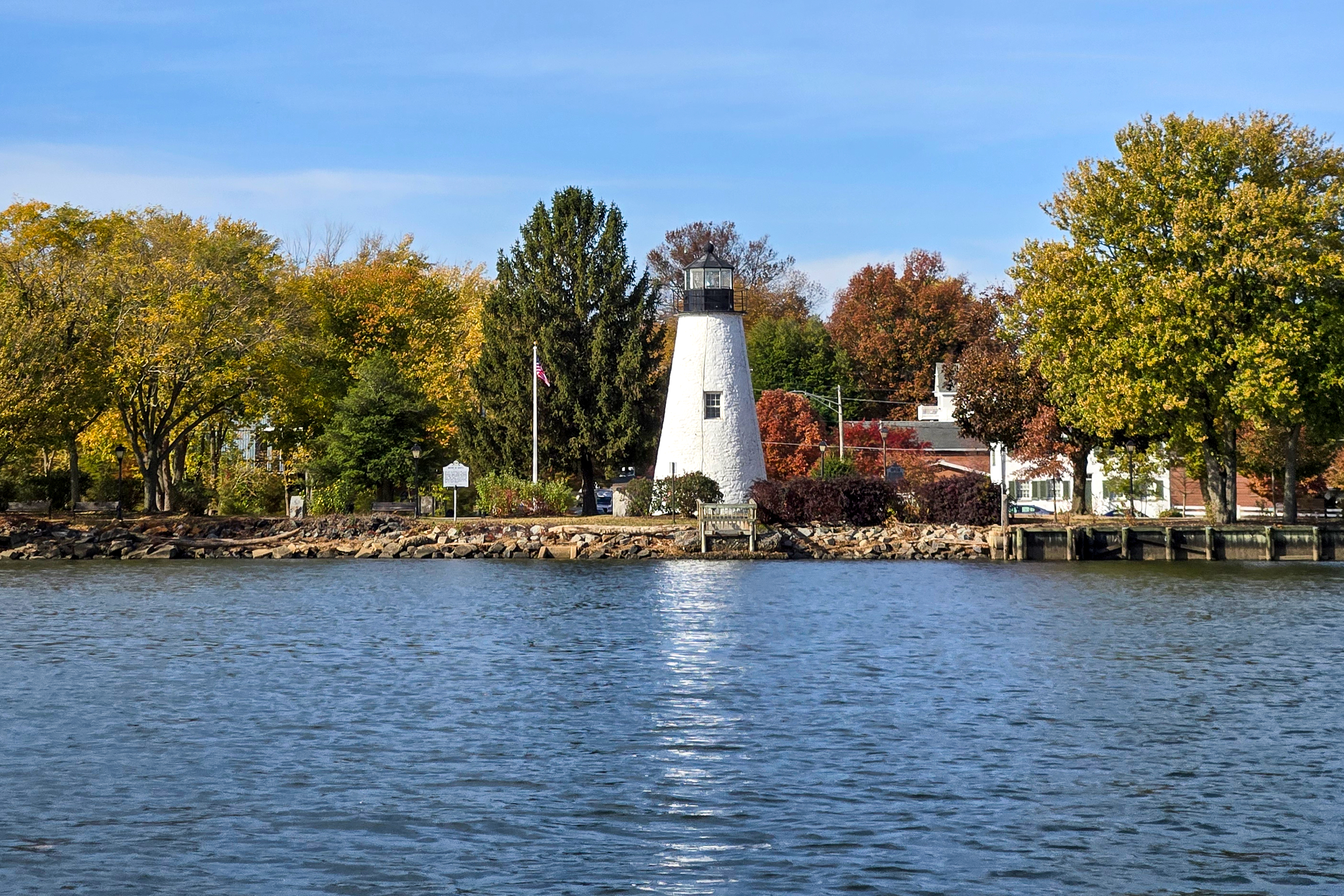
Explore the Lower Susquehanna Heritage Greenway, where trails, parks, and historic sites link the Susquehanna River Valley to the Chesapeake Bay. Connect with Indigenous heritage, African American history, and nationally recognized trails while discovering the natural beauty and cultural significance of Maryland’s Upper Bay region.
The image depicts the Concord Point Lighthouse situated along a body of water. The lighthouse is cylindrical and painted white, with a black lantern room at the top. Surrounding the lighthouse, there are trees with autumn foliage in shades of gold, orange, and green. A stone wall lines the shore, and a small dock is visible in the water. To the left of the lighthouse, there is a flagpole with an American flag. The sky is clear with a few wispy clouds.
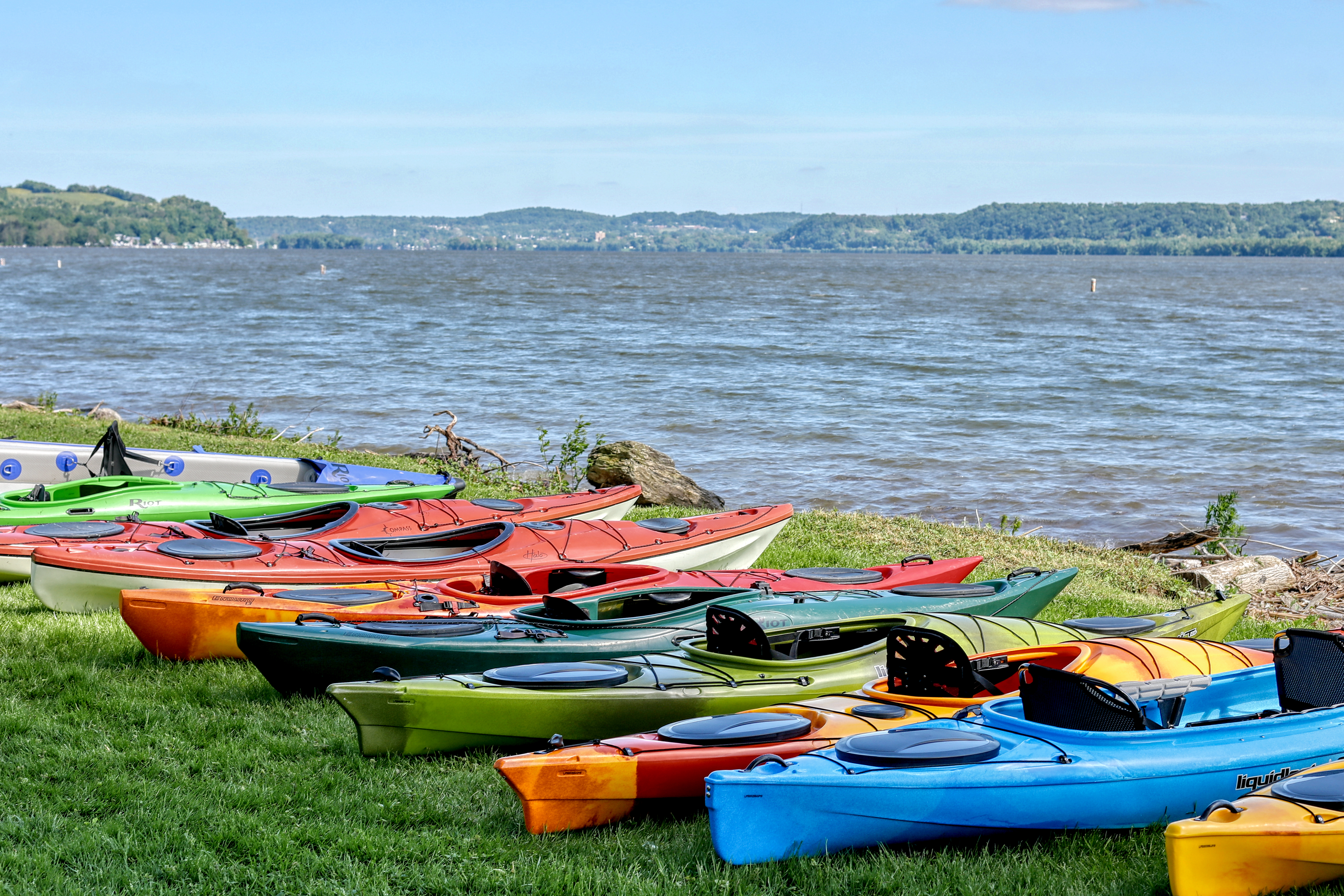
Paddle 53 miles along the Susquehanna River from Harrisburg to Maryland, experiencing scenic vistas, historic river towns, and unique wildlife habitats. Interpretive panels, trail maps, and access to the Captain John Smith Chesapeake National Historic Trail enrich the journey along one of the Chesapeake Bay’s vital tributaries.
The image shows a collection of colorful kayaks arranged on a grassy shore next to a large body of water. The kayaks vary in colors including red, blue, orange, green, and yellow, and are neatly aligned, partially overlapping one another. In the background, a calm lake extends toward a distant line of green, tree-covered hills under a clear blue sky. The water has gentle waves, and the grassy area includes a few scattered rocks and small shrubs.
Machicomoco State Park, located on the York River, is dedicated to telling the story of Virginia's Indigenous peoples. Its name, Machicomoco, means "a special meeting place" in the Virginia Algonquian language. At the park, miles of trails, a fishing pier, a paddle craft launch, and campground sites offer many ways to recreate at the park. Visit the interpretive area to learn more about Native American culture and history.
A state park in coastal Virginia. The park has large agricultural fields in the center and is bounded on three sides by a wide river. A paved hiking trail follows the fields around the entire park, where it meets up with campgrounds, fishing piers, historic areas, and boat launches around the perimeter. In the historic area, a historic plantation house stands in addition to a model Indigenous longhouse constructed artistically from a metal structure.
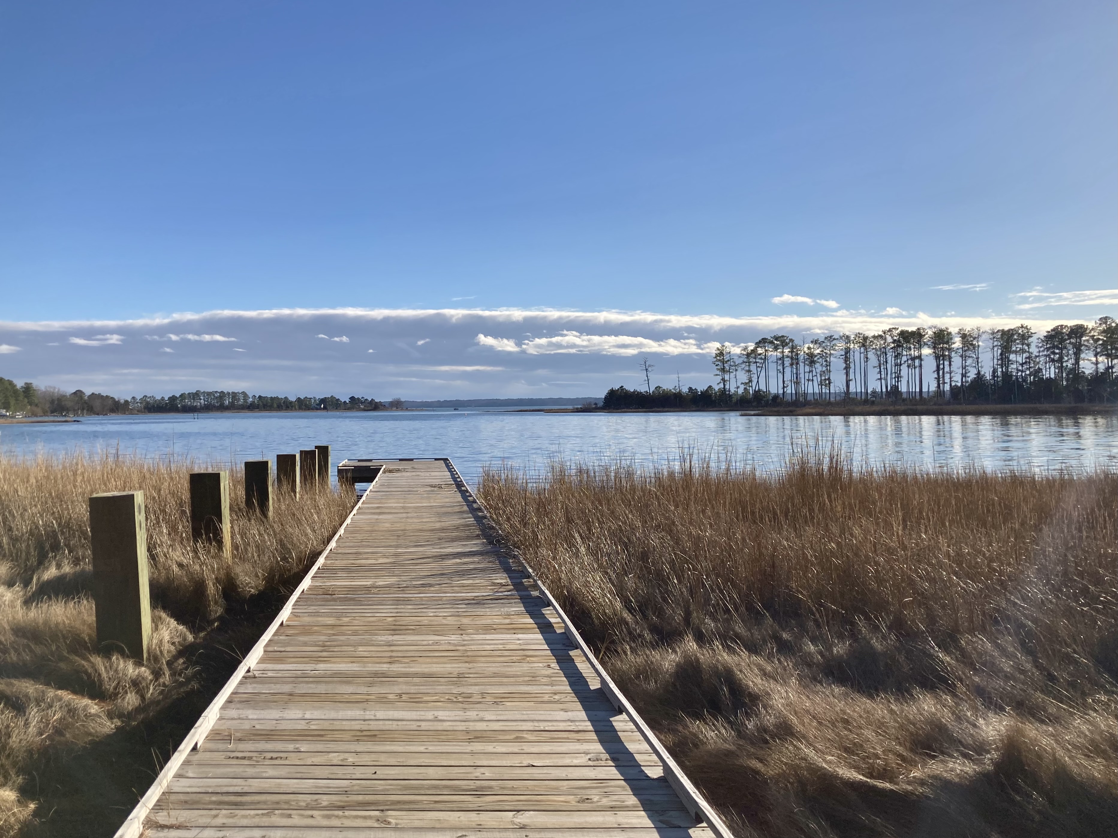
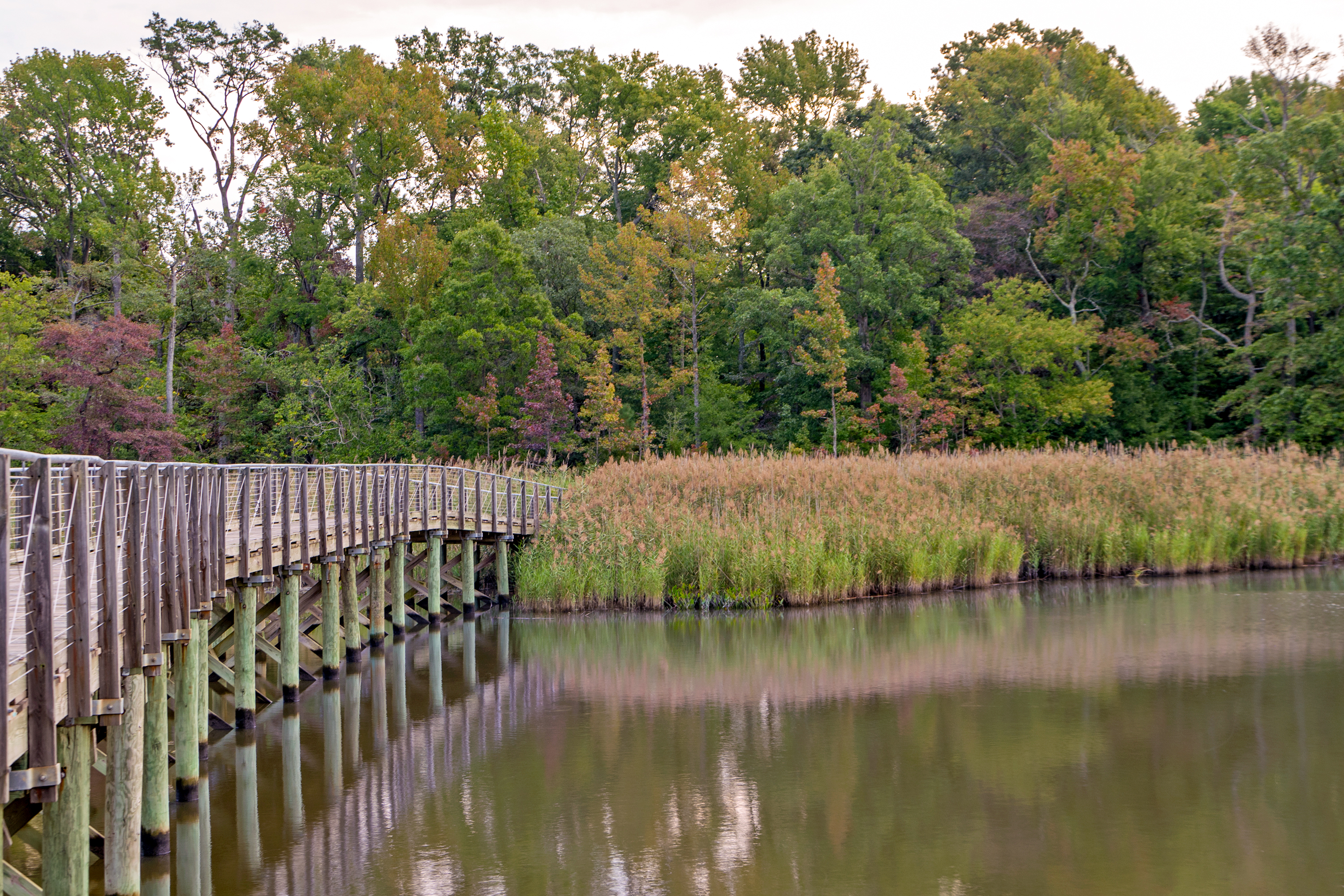
Explore forests, meadows, wetlands, and tidal marshes at this Chesapeake Gateways Network Site in Baltimore County. Marshy Point Park features a canoe and kayak launch, 8 miles of trails, and a nature center with live animals and exhibits on estuarine ecology, history, and conservation.
The image depicts a wooden footbridge extending over a calm body of water, reflecting the surrounding vegetation. The bridge has vertical railings and is supported by evenly spaced wooden piers. To the right of the bridge is a dense section of tall grasses growing along the water’s edge. In the background, a variety of trees with lush foliage can be seen. The trees display autumnal hues, with greens interspersed with shades of orange and reddish-brown.
Maryland Avenue is home to a quaint and quiet shopping district, featuring eclectic businesses and restaurants. The Maryland State House stands at one end, with the walls of the Naval Academy at the other. On this street you will find two significant historic homes, the Chase-Lloyd House and the Hammond-Harwood House.
Maryland Avenue intersects perpendicularly with Prince George Street, King George Street, and other streets in downtown Annapolis. It has a number of historic buildings, many made with red brick similar to other buildings downtown. In contrast to Pinkney Street, Maryland Avenue has residential and commercial properties. On the block between Prince George Street and King George Street, there are a few large historic homes on larger plots of land, rather than a connected row home. Some properties have fences, but others do not. The Maryland State House is visible at the southwest end of the street, which has more commercial properties.
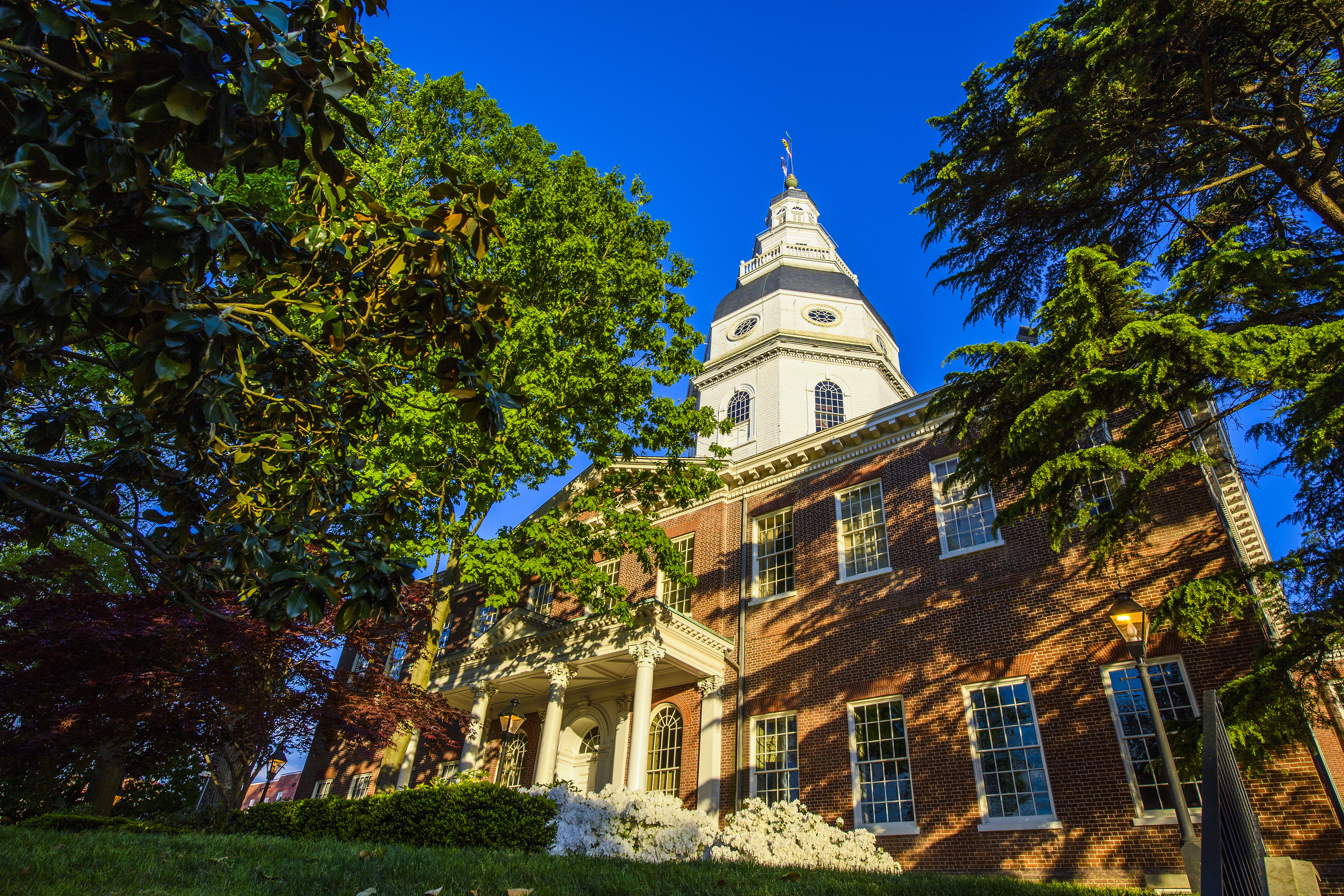
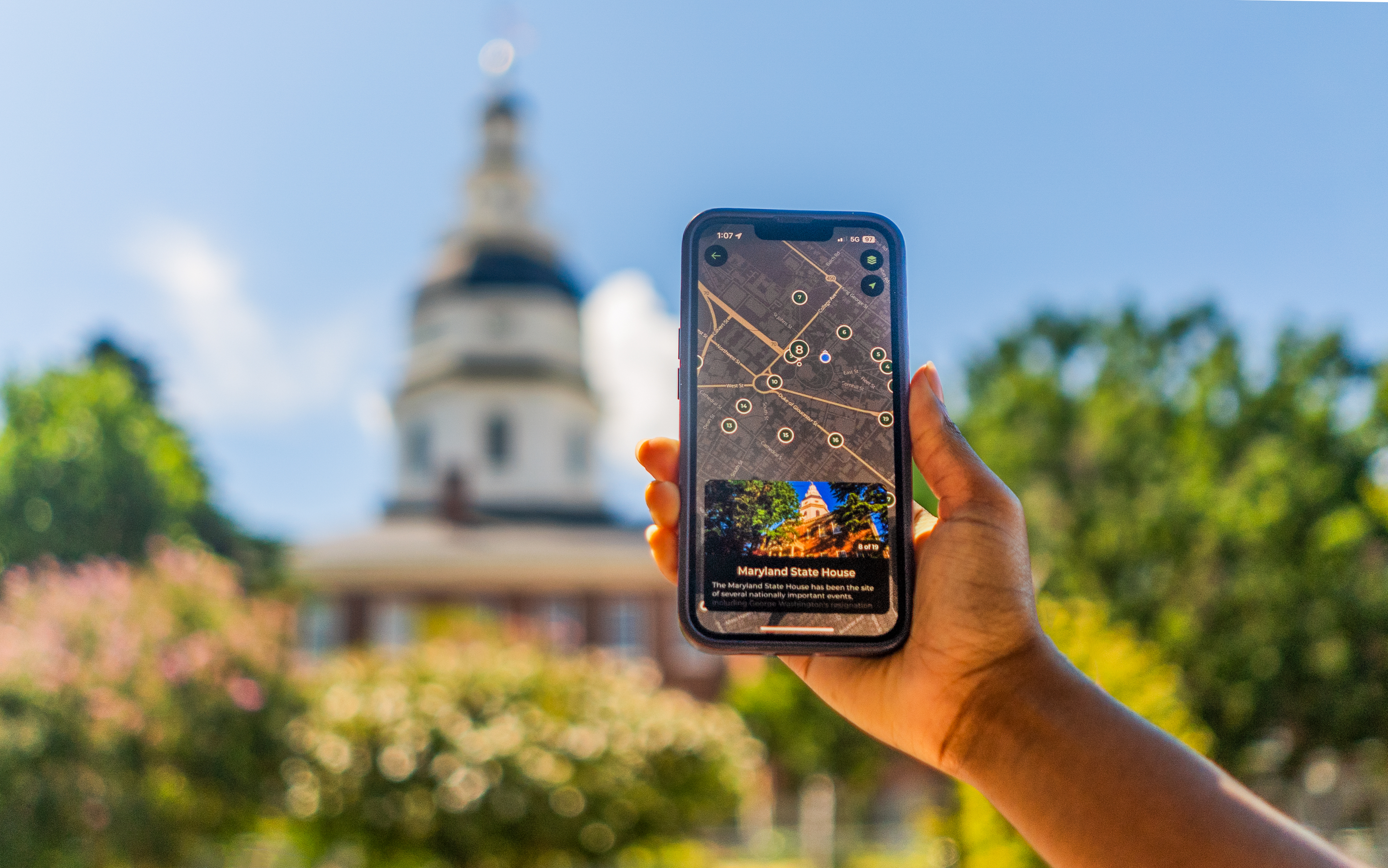
The Maryland State House has been the site of several nationally important events, including George Washington's resignation as commander-in-chief of the Continental Army after the American Revolution, and the ratification of the Treaty of Paris. The rich architecture and history of the building was recognized in 1960 when the State House was designated as a National Historic Landmark.
The Maryland State House, situated on a hill in the middle of a large roundabout with streets radiating outward, is a large building with a dome flying Maryland and United States flags. The top of the dome is a golden acorn with a lightning rod at the top. The hill has grass, a number of walkways, benches, and large trees. There is another small brick building on the grounds of the State house, which previously served as the Maryland Treasury building. The entire hill is ringed with a short brick wall and a sidewalk made of the same red brick found elsewhere in downtown Annapolis. Businesses and commercial properties in historic buildings ring the outer side of the street.
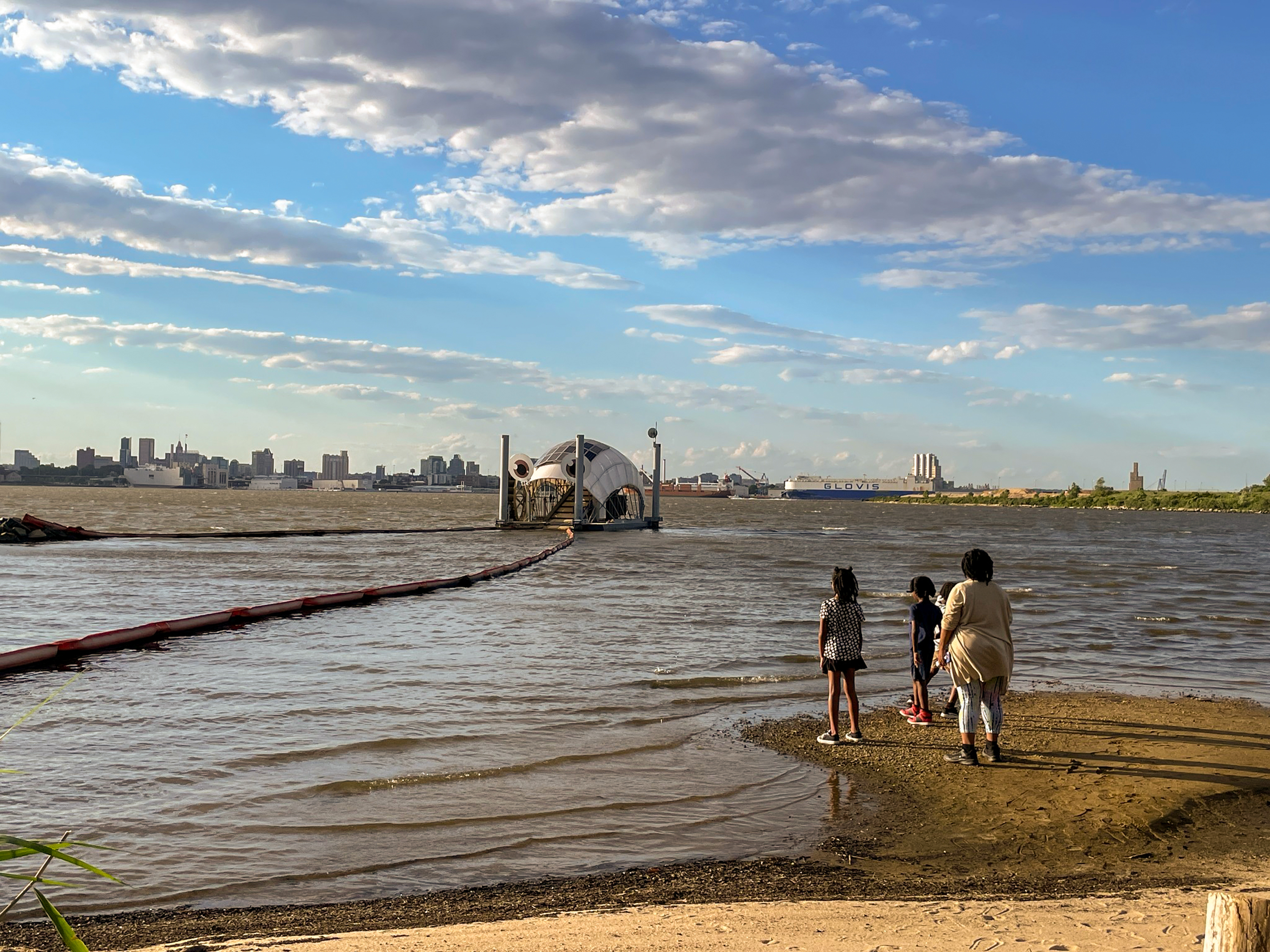
Masonville Cove is a restored urban wildlife refuge offering hands-on exhibits, nature trails, birdwatching, and family-friendly education programs that connect visitors to the Chesapeake Bay.
The image shows a waterfront scene with a family of four standing on a small sandy area, gazing towards a body of water. In the background, a large, dome-shaped floating structure with two circular openings is situated on the water. This structure is connected to a long, floating barrier extending from the shore. The sky above is mostly clear with a few scattered clouds, and a distant city skyline is visible across the water. The sunlight casts a warm glow over the scene.
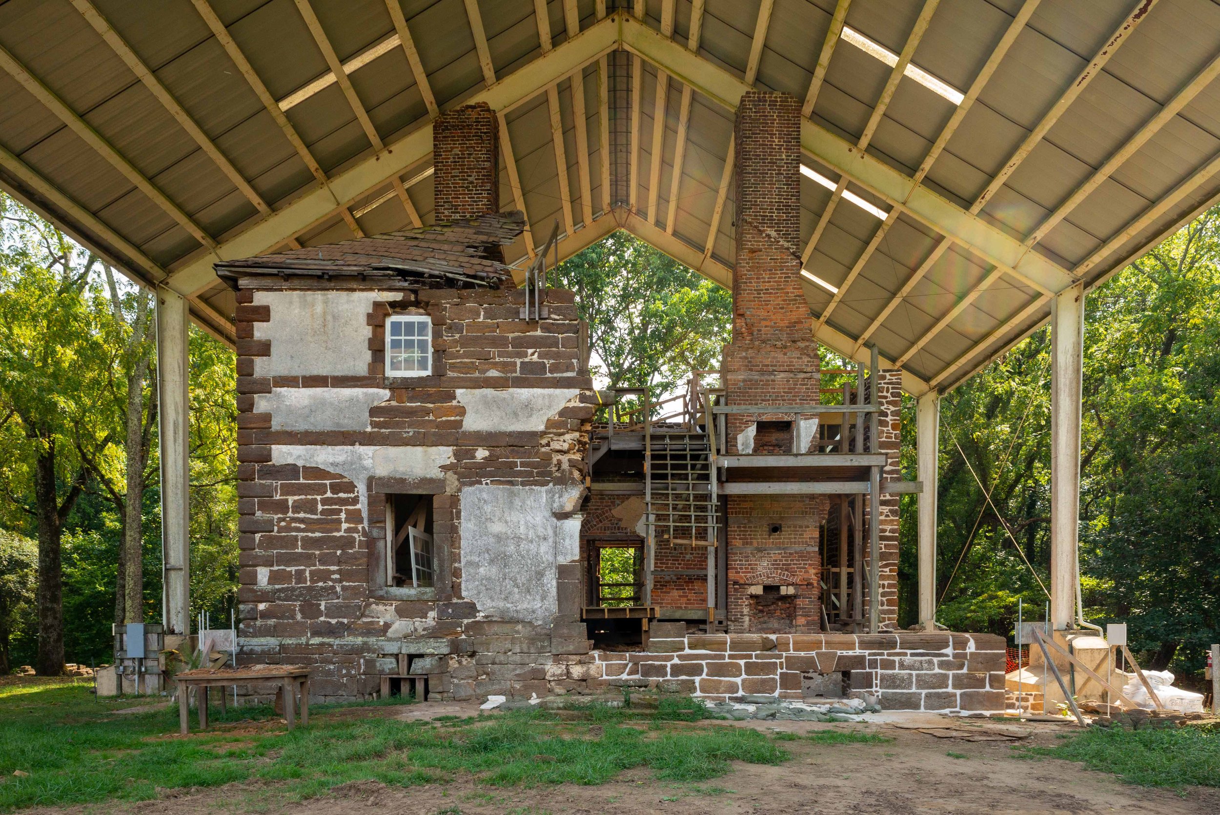
Explore Menokin, a National Historic Landmark where history, architecture, and conservation meet. See the 1769 home of Francis Lightfoot Lee, witness innovative preservation in action, and walk trails through a protected Chesapeake Bay watershed landscape. Engage with exhibits, hands-on activities, and the powerful stories of those who shaped this place. Paddle Cat Point Creek, connect with nature, and uncover the past in a truly unique setting.
The image shows a partially reconstructed historical building beneath a protective metal roof structure supported by white beams. The building is built from dark brown brick with patches of exposed and weathered areas revealing a lighter material underneath. The roof of the building is mostly collapsed, and there is a large, intact chimney. A staircase made of wood leads to an elevated platform adjacent to the chimney, making the structure appear skeletal. To the left, there is a small table or bench with no items on it. The surrounding area is grassy with trees and sunlight filtering in from the top right, casting shadows and creating a serene, yet somber, atmosphere.
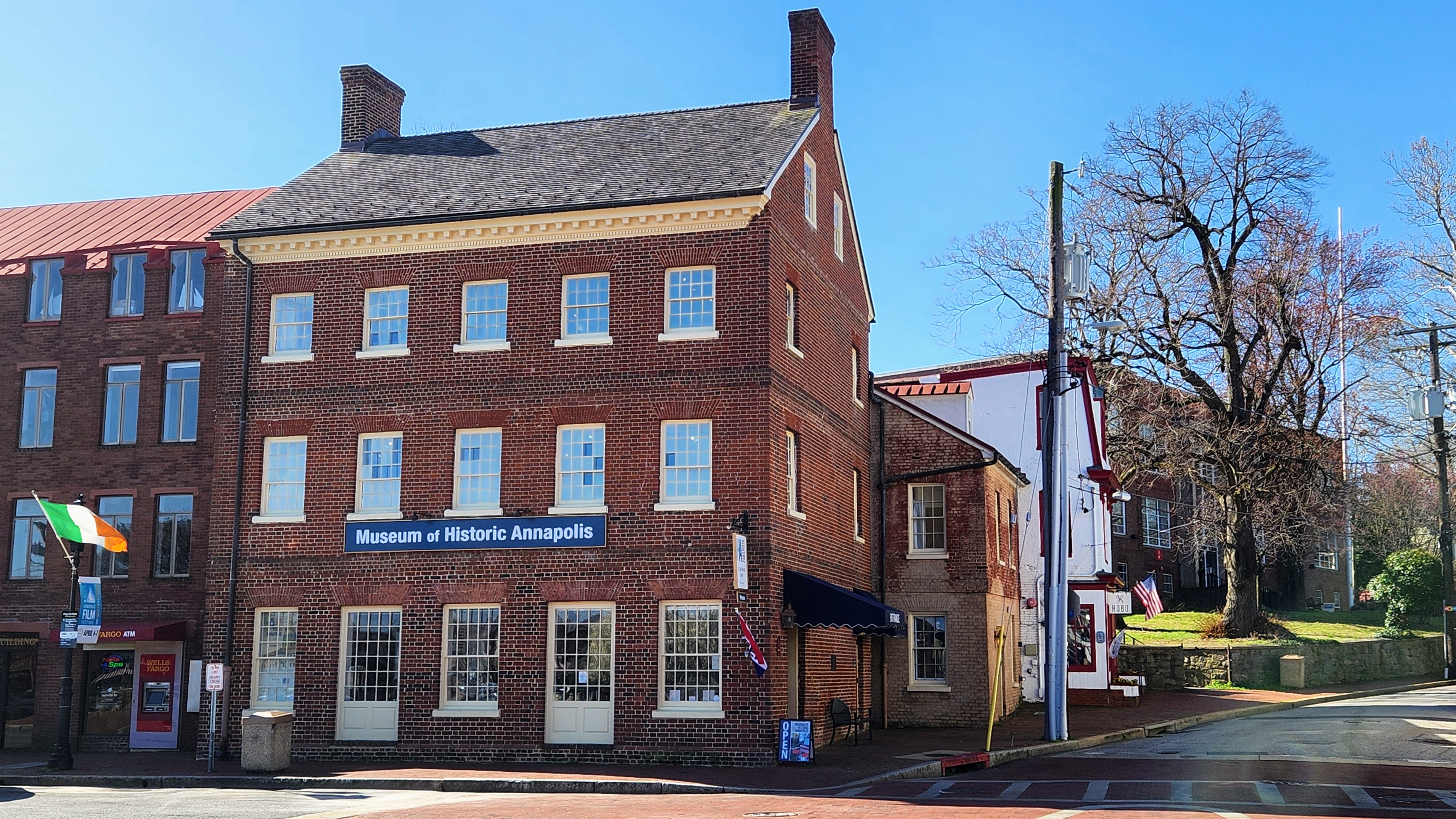
At the Museum of Historic Annapolis, discover the rich history of the city through interactive exhibits and authentic stories spanning over 400 years. Explore diverse perspectives, from Native peoples to revolutionaries and civil rights leaders. Engaging displays and community-sourced artifacts bring the past to life in a historic 18th-century building.
On the southeast end of Main Street, Ego Alley is visible to the east past a traffic circle and small park area. Main Street, a narrow, one way road with businesses and residences on upper floors, continues to the west. Main Street combines historic architecture with modern amenities, and is typically busy with foot traffic and car traffic. To the southwest, on the corner of Green Street and Main Street is a three story brick building with a sign that reads “Museum of Historic Annapolis”. Each story has a row of five windows with small glass panes. The building is connected to a row of buildings made of similar red brick, most of which are commercial businesses.
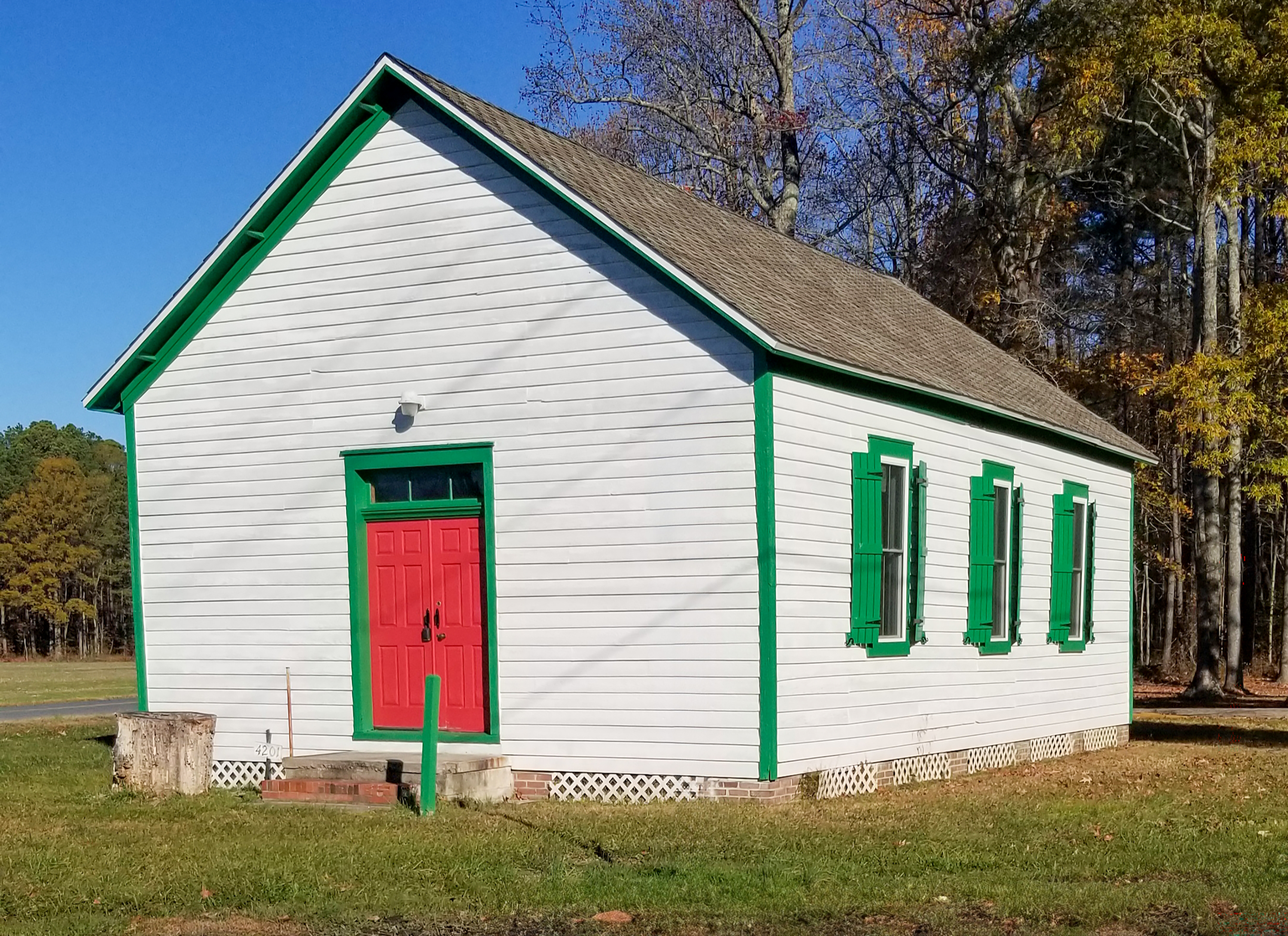
Connect with the Chesapeake Bay’s Indigenous heritage at the Nause-Waiwash Band of Indians’ National Register-listed Longhouse and annual Native American Festival. Learn about the traditions, resilience, and living history of the Nanticoke and Choptank communities on Maryland’s Eastern Shore. Visits are available by appointment.
The image depicts a small, rectangular building with white wooden siding and a gabled roof covered in brown shingles. The trim around the building is painted green, including the window frames and the outlines of the structure. There are four windows on the visible side of the building, each with green shutters. The front of the building features a bright red double door framed with green trim. Above the door is a small, square transom window. A concrete step leads up to the entrance, and a metal post is positioned near the steps. The building is set against a backdrop of leafless trees, suggesting late autumn or early winter. The sky is clear and blue, and the ground is covered with short grass.
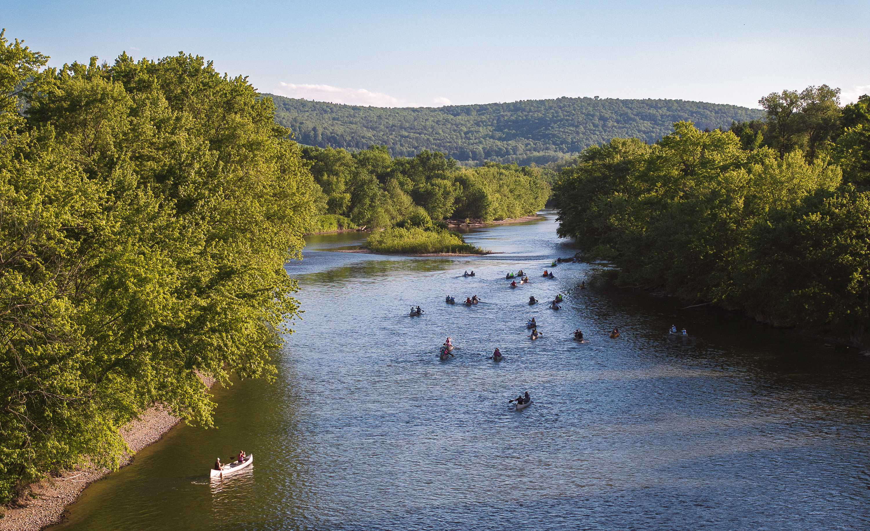
Explore the New York Susquehanna Basin Water Trail’s scenic rivers, vibrant towns, and new public access points. Paddle through the Chesapeake Bay’s northern headwaters and discover how recreation, heritage, and conservation come together along this new water trail connecting New York and Pennsylvania.
The image depicts a serene river scene along the New York Susquehanna Basin Water Trail. In the foreground, a group of people in canoes paddle down the river, which flows towards the center of the image. The canoes are variously spaced throughout the water, creating a sense of leisurely motion. Dense, lush green trees line both sides of the river, casting shadows on the water. In the background, rolling hills covered in trees rise beneath a clear blue sky, adding to the tranquil and natural setting. The lighting suggests it is likely late afternoon with sunlight filtering through the trees.
Just a short drive from many Mid-Atlantic cities, the Northern Neck National Heritage Area offers a journey back in time. Whether for a day, weekend, or week, you’ll find endless opportunities to explore history, enjoy coastal charm, and experience natural beauty. From historic sites to scenic byways, there’s always something new to discover in this unique corner of Virginia.
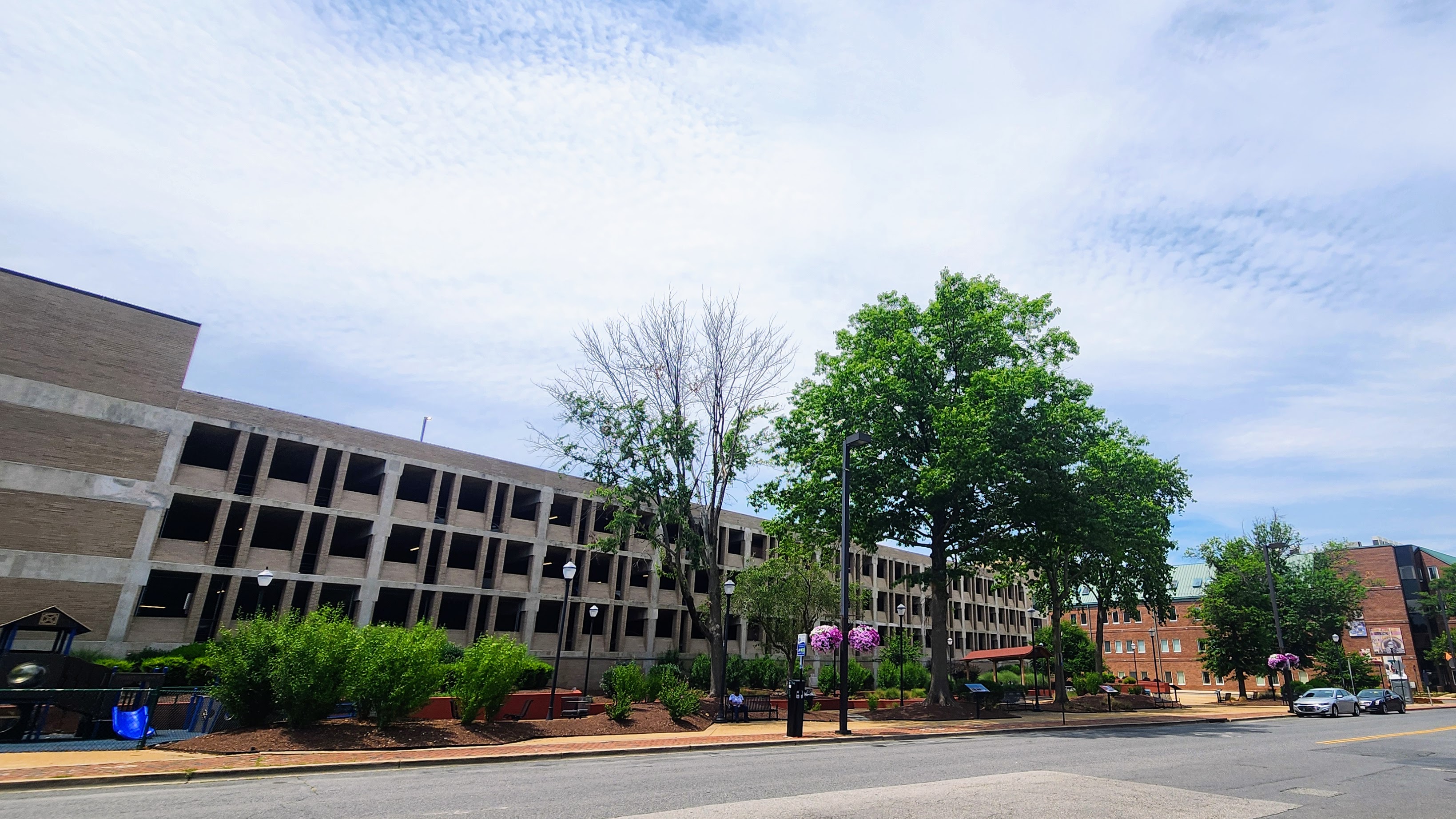
The People’s Park stands in what was formerly the Old Fourth Ward and honors those displaced by urban renewal. The neighborhood earned the nickname “Annapolis Harlem” and was the home to an impressive music scene in the early 1900s.
A small park with benches, trees, and landscaping sits on the west side of Calvert Street near a few city garages. The park has a small blue playground, a few tables with built-in chairs, and a covered pavilion. There are lamps in the park modeled to look historic, and streetlights on the end of the sidewalk by the road that are taller and more modern. On the opposite side of the street, there is a colorful mural on the side of a building.
Explore Annapolis on a self-guided walking tour that highlights centuries of history along the Chesapeake Bay. Visit the Maryland State House, the U.S. Naval Academy’s John Barry Gate, historic churches, homes of free and enslaved African Americans, and the Banneker-Douglass-Tubman Museum. This walk offers a meaningful way to connect with the city’s political, cultural, and maritime heritage.
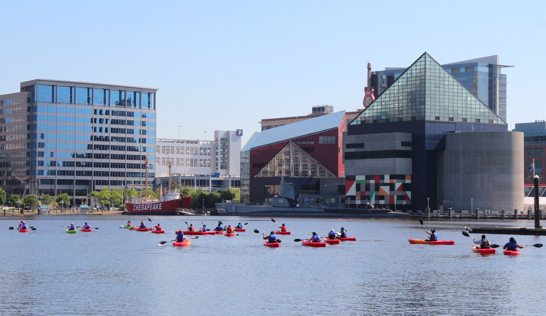
Paddle the Baltimore Blueway
Choose from 30 miles of trails in the Inner Harbor, Outer Harbor, Middle Branch, and Patapsco River. Imagine yourself gliding alongside historic ships, seeing the skyline from the water, and paddling around Fort McHenry. Take a selfie with Mr. Trash Wheel or immerse yourself in nature surrounded by wetlands and wildlife. Nowhere else in the Chesapeake Bay can you find such a diverse range of awe-inspiring paddling experiences within a 3-mile radius.
Paddle the Potomac River
Beginning at Jennings Randolph Lake to the mouth of the Potomac, you may choose to paddle the 355 miles to the Chesapeake Bay or take a single or multi-day trip; all will give you a different view of the ways that previous residents used the river and its banks for their livelihood, transportation and recreation.
Paddle the Patuxent River Water Trail
The Patuxent River Water Trail offers visitors the opportunity to paddle the river, camp along its banks and visit its numerous parks, historic sites, sanctuaries and wildlife areas. The 110 mile-long river is unique in that it is the longest river that flows entirely within the state of Maryland.
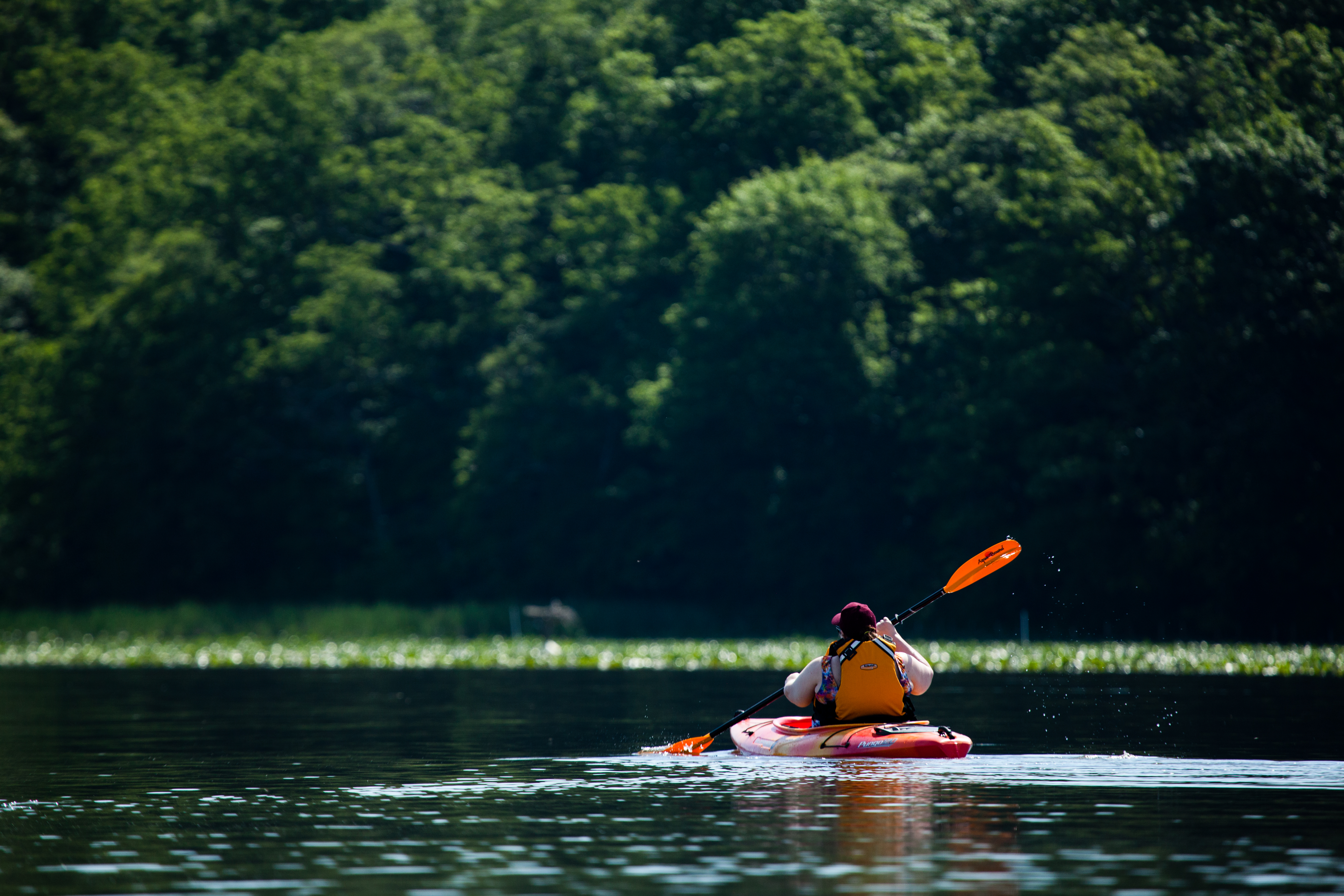
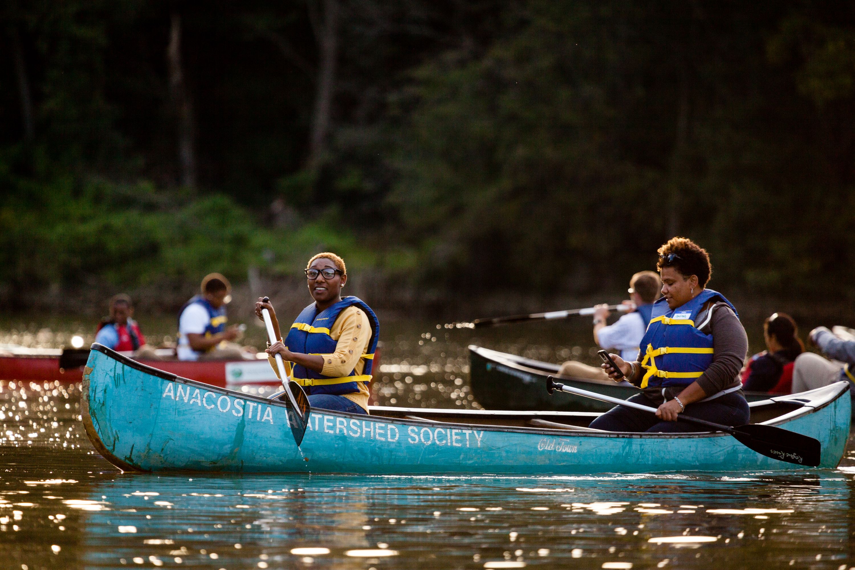
Paddle the Anacostia Water Trail
Discover the natural abundance of the Anacostia River as it threads through the heart of Washington, DC. Watch birds on Kingman Island or dock at the National Arboretum and roam the forest. The Anacostia River corridor has lots of options for outdoor fun and the Anacostia Water Trail can help you find them.
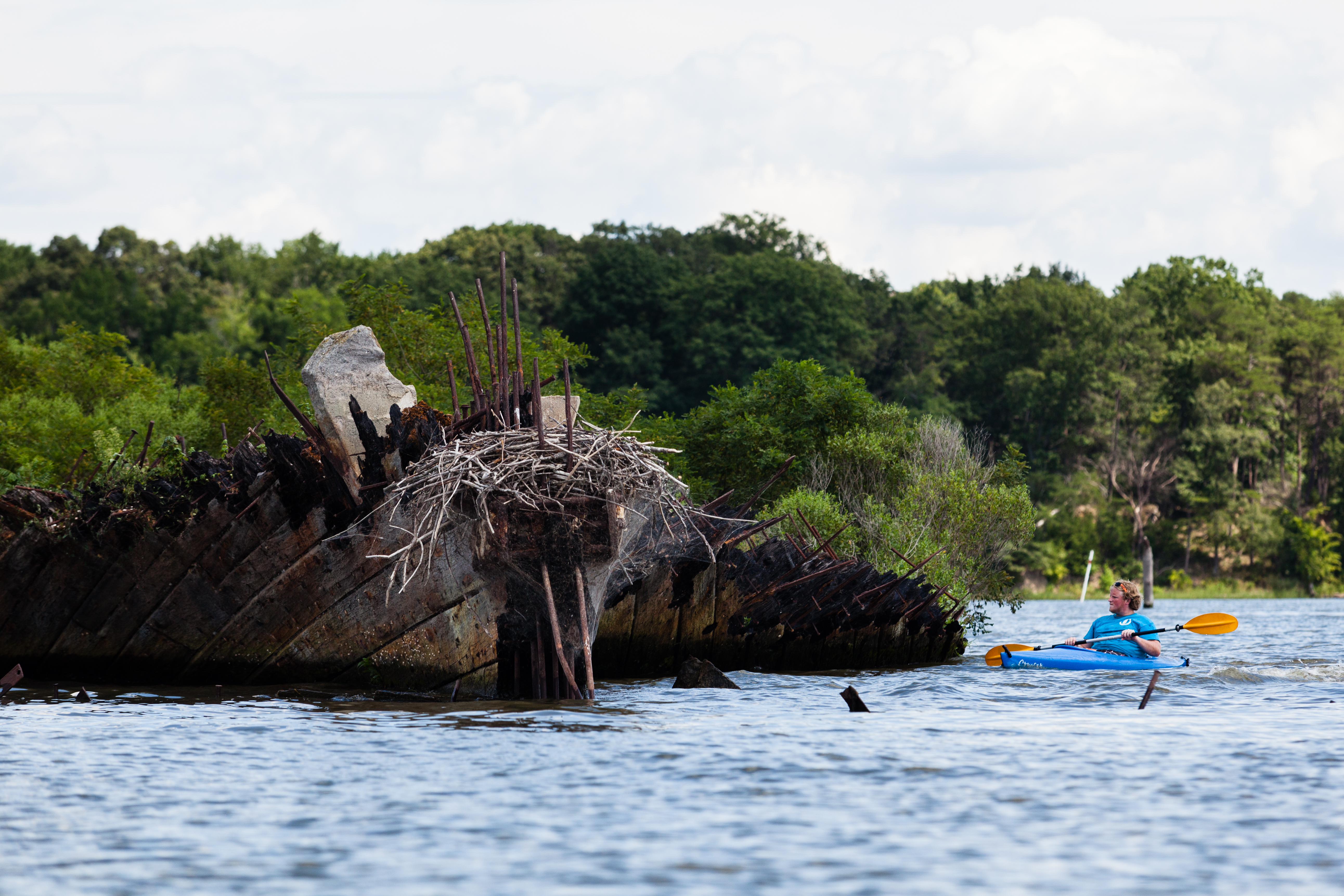
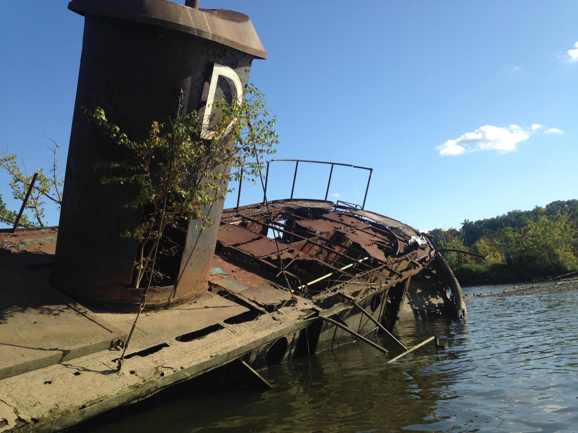
Paddle to Sunken Ships at Dutch Gap Conservation Area
Dutch Gap Conservation Area is a wooded area in Chesterfield County, Virginia that surrounds Henricus, the second successful English settlement in Virginia. Paddle the Lagoon Water Trail to view abandoned barges, relics of the river's industrial past.
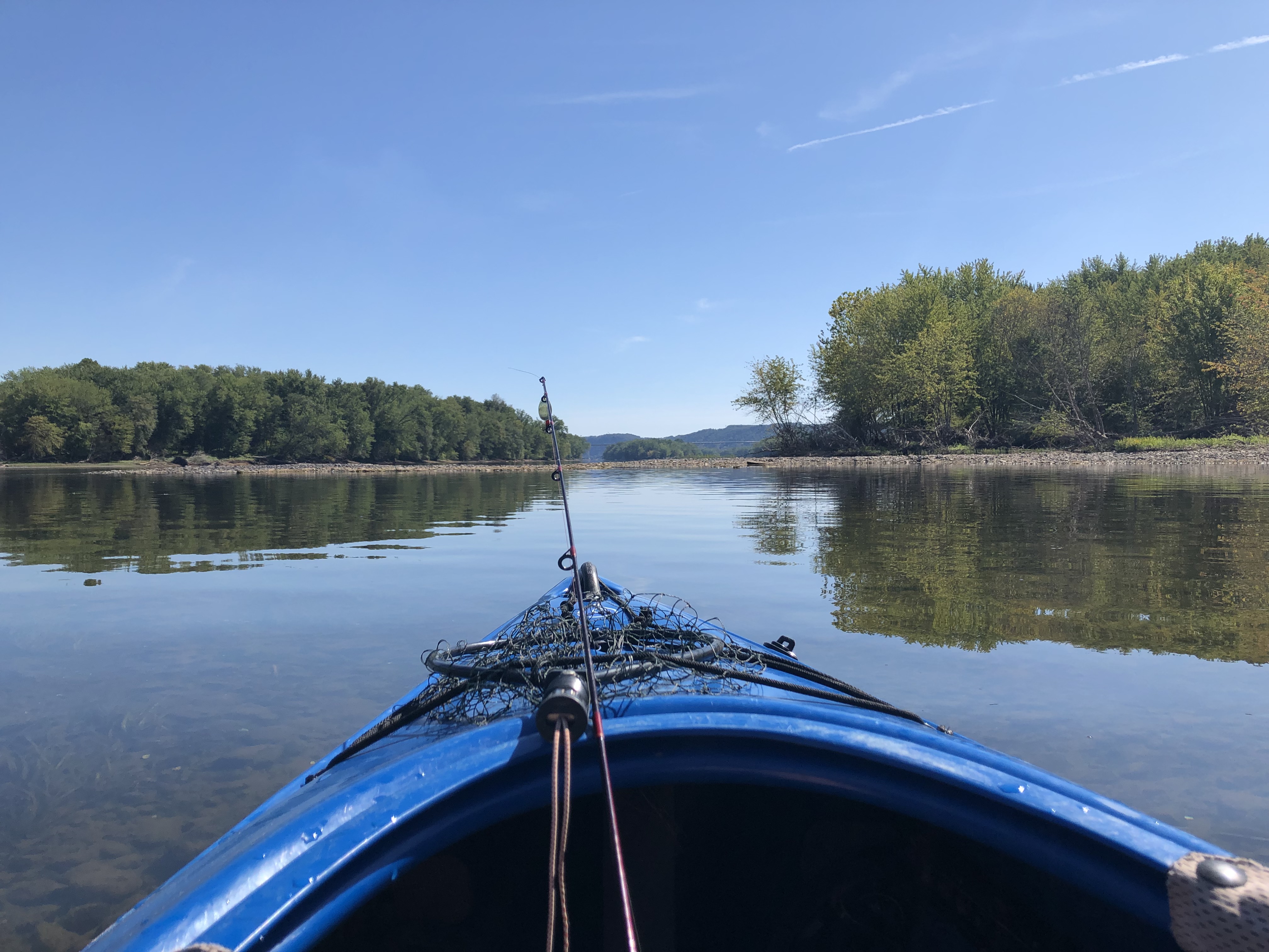
Paddle the Susquehanna
The Susquehanna River is the longest river in the Eastern United States and the 16th longest in the country at 444 miles long. The Susquehanna forms from two branches that meet in Sunbury, Pennsylvania. The North Branch comes from Cooperstown, New York and the West Branch that rises from the borough of Carrolltown, Pennsylvania.
Paddle the Sassafras River Water Trail
The Sassafras River Water Trail is a 22 mile-long route located in the Upper region of the Chesapeake Bay. The river trail offers several options for paddle trips in beautiful landscapes that are rich in history.
Paddle Leonardtown to Colton's Point
Paddle approximately 12 miles from Leonardtown to Colton's Point via kayak or canoe, stopping at Newtowne Neck State Park. The trip is mostly on Breton Bay, but joins the Potomac and the mouth of St. Clement's Bay near Colton's Point.
Tours
Count: 1
Historic Annapolis Walking Tour
Enjoy this self-guided walking tour of historic Annapolis, Maryland, part of the National Park Service Chesapeake Gateways.