Fort Foote was constructed in 1863 atop Rozier's Bluff to strengthen the ring of fortifications that encircled Washington, D.C. Two of the Guns that protected Washington are still there along with the remains of the fort's earthworks.
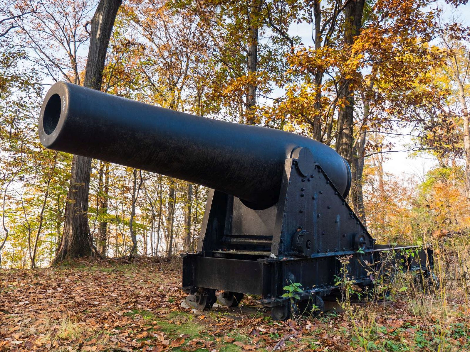
Spaced about 70 yards apart two massive cannons point out over the water. Each cannon is roughly 12 ft long and is mounted on a large metal base which raises it to about 15 ft high. The barrel of the cannon is 15 in in diameter. Both Canon and base are painted black. This rests on a half circle mounts made of stone and metal.
Fort Foote was named after Rear Admiral Andrew H. Foote. He distinguished himself in the actions against the Confederate forts on the Mississippi River and died of wounds on June 26, 1863.
A small overgrown fort. The fort is constructed of earth and some stone and is now covered in a forest ecosystem. On the Western side of the fort sit two 7 ft tall cannons.
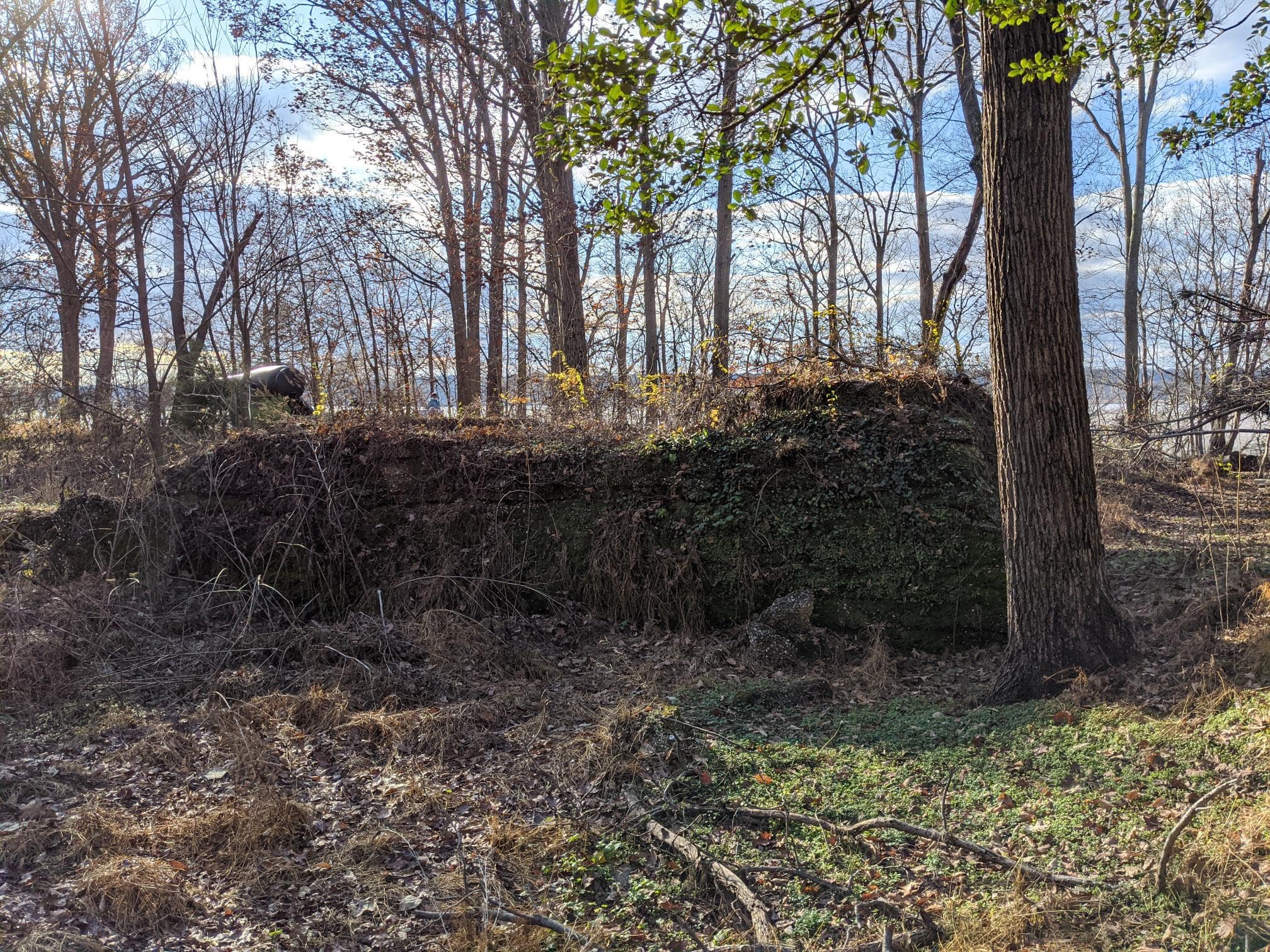
Located in the center earthwork of Fort Foote the bomb proof magazine is a short t-shape structure measuring about 50 by 50 ft. It is made of a cement-like material filled with small pebbles. It has many tunnels overgrown with moss vines and shrubs. The structure has seen much where over the past century and is in disrepair.
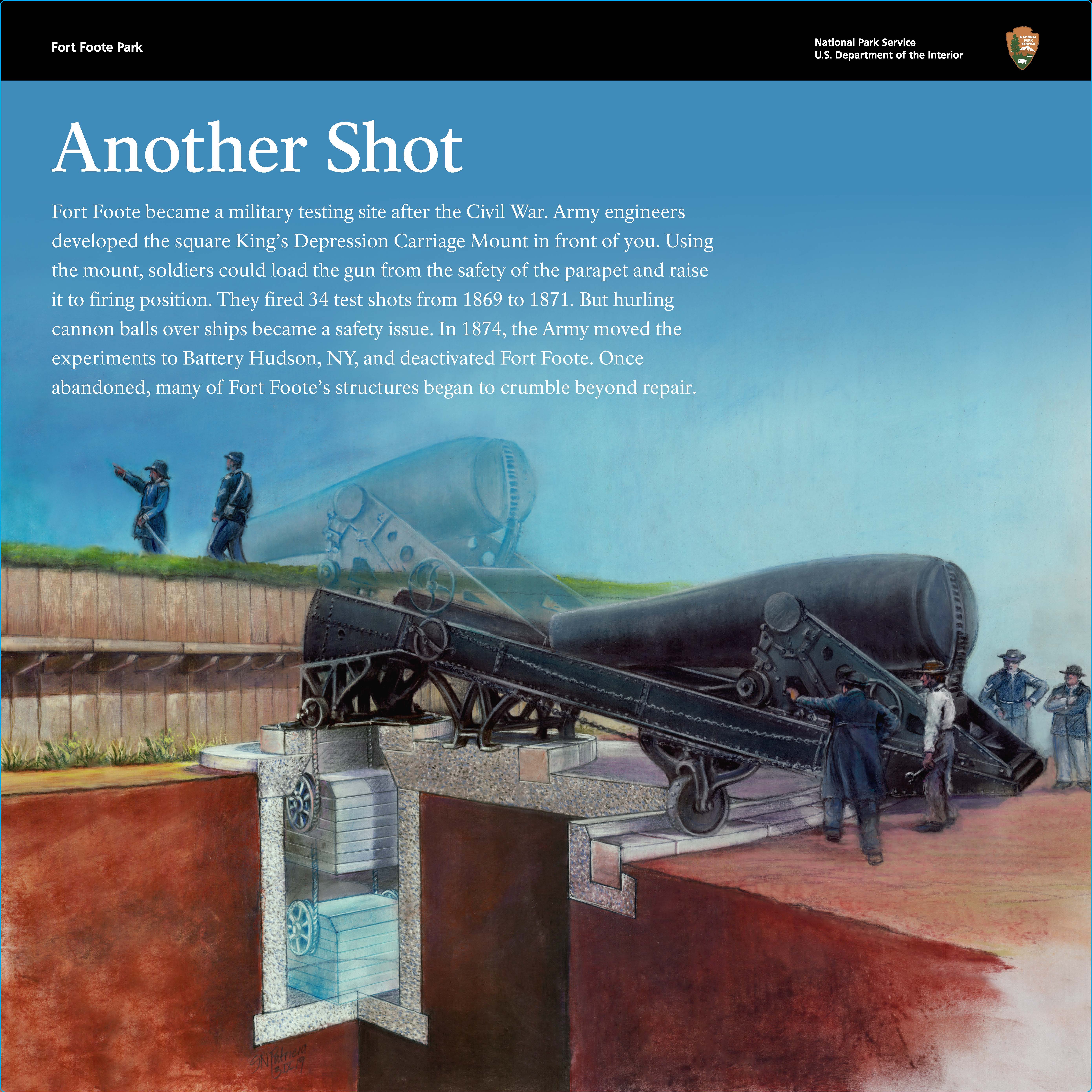
¬Slanted Wayside Panel: Another Shot 408 words / Panel Description: 2.75 minutes In front of you, is a panel 2 feet wide by 2 feet tall, and 3 feet off the ground, on dark brown painted aluminum posts. In metric, that is about a half meter wide by a half meter tall, and about 1 meter off the ground. To the left of the panel, is a steep, grassy hill. Ahead is a mown path. To the right of the panel, are dense trees. A concrete slab roughly 1 yard or 1 meter square lies behind the panel. In the center, is a round metal cylindrical mount. At the top, is white text on a blue background: Another Shot. Fort Foote briefly became a testing site after the Civil War. Army engineers developed the square King’s Depression Carriage Mount in front of you. Using the mount, soldiers could load the gun from the safety of the parapet and raise it to firing position. They fired 34 test shots from 1869 to 1871. But hurling cannon balls over ships became a safety issue. In 1874, the Army moved the experiments to Battery Hudson, New York, and deactivated Fort Foote. Once abandoned, many of Fort Foote’s structures began to crumble beyond repair. End of Text Below the text, is a color illustration that shows how the King’s Depression Carriage Mount works. A black Rodman Gun sits on a gray concrete foundation dug into the earth. The gun is about 15 feet long by 8 feet tall, or 5 meters long by 2 and a half meters tall. The reddish-brown dirt is cut away to show the underground supporting structure. The gun consists of a large horizontal carriage with a bottle-shaped cannon on top. The gun points to the left, toward the river. Below ground, are stacked gray counterweights to balance the gun for raising and lowering it. On the right, four soldiers stand at the base of the gun, ready to push it up and over the fort wall to fire. On the left, two soldiers stand on top of the fort wall. The fort wall is built of upright logs and topped with green grass. One soldier points towards the river. Over the color illustration, is a ghosted illustration of the Rodman Gun in firing position. To fire, the soldiers pivot the enormous gun on its mount to raise it over the fort wall. At the same time, the counterweights below drop into a deep pit. After firing, the gun’s recoil slides it back down the mount to its resting position. [End of message]
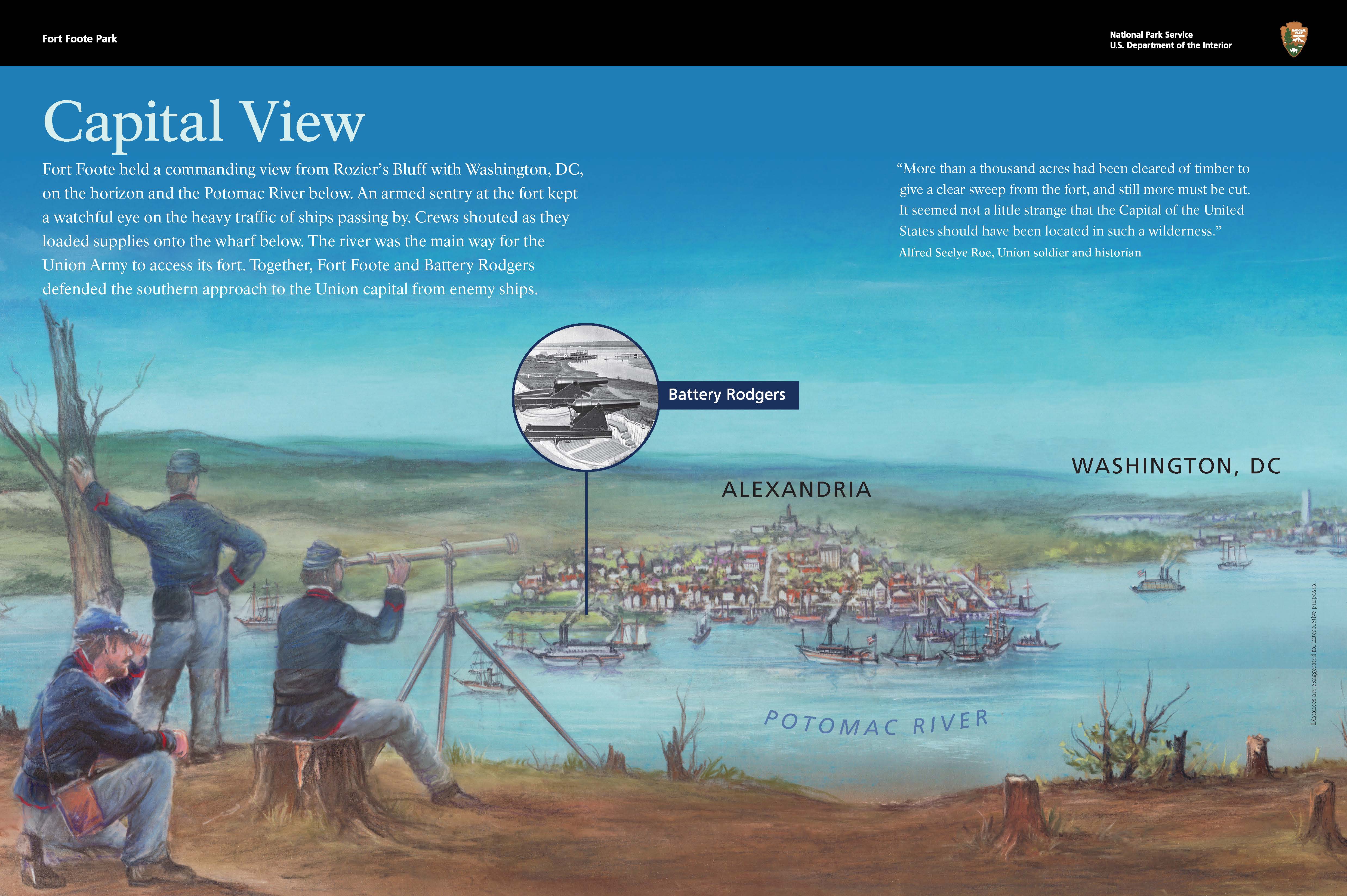
Slanted Wayside Panel: Capital View 393 words / Panel Description: 2.5 minutes In front of you, is a panel 3 feet wide by 2 feet tall, and 3 feet off the ground, on dark brown painted aluminum posts. In metric, that is about 1 meter wide by a half meter tall, and about 1 meter off the ground. This panel overlooks the Potomac River. On the top left, is white text on a blue background: Capital View. Fort Foote held a commanding view from Rozier’s Bluff with Washington, DC, on the horizon and the Potomac River below. An armed sentry at the fort kept a watchful eye on the heavy traffic of ships passing by. Crews shouted as they loaded supplies onto the wharf below. The river was the main way for the Union Army to access its fort. Together, Fort Foote and Battery Rodgers defended the southern approach to the Union capital from enemy ships. End of Text On the top right, is white text on a blue background: “More than a thousand acres had been cleared of timber to give a clear sweep from the fort, and still more must be cut. It seemed not a little strange that the Capital of the United States should have been located in such a wilderness.” Alfred Seelye Roe, Union soldier and historian End of Text A color illustration fills the panel. At the bottom left, are 3 soldiers at the edge of the brown bluff. Beyond the bluff, the blue Potomac River flows from left to right. One soldier is sitting on a tree stump with a telescope pointing toward the river. A second soldier kneels behind him, looking at the river. To the left, a third soldier leans against a brown tree. There are several masted ships, ironclad ships, and small ships on the river. The City of Alexandria is in the middle of the panel. The city has white buildings with red roofs. At the left end of the city, is a round inset black-and-white photograph of 2 Rodman Guns. These guns are located at Battery Rodgers in Alexandria. Beyond Alexandria, is green farmland. Farther back and to the right, is the edge of Washington, DC. Several buildings and the unfinished Washington Monument are shown. The horizon beyond fades into blue sky. The view is unobstructed by trees. In the bottom right corner, is black text on a blue background: Distances are exaggerated for interpretive purposes. End of Text [End of message]
¬Slanted Wayside Panel: Engineering Evolution 424 words / Panel Description 2.75 minutes In front of you, is a panel 3.5 feet wide by 2 feet tall, and 3 feet off the ground, on dark brown painted aluminum posts. In metric, that is about 1 meter wide by a half meter tall, and about 1 meter off the ground. In front of the panel are the crumbling concrete remains of the fort’s magazine. Tall trees and green bushes grow on this mound of remains. In the top left, is light text on a dark background: Engineering Evolution. The crumbling concrete before you is all that remains of the magazine. It’s one of the few left of its kind from the Civil War. Inside the magazine’s storage rooms, barrels held 40-pound, or 18-kilogram, linen bags of black powder. Soldiers carefully carried pass boxes filled with bags to the Rodman Gun to ready its next shot. End of Text Below the text, is a rectangular concrete model, about 1 foot wide by a half foot tall. It is smooth on the left and bumpy on the right. Above the model, is a rectangular bronze plate that displays Concrete in English and Braille. Below the model, is white text on a dark background: The magazine is fragile. Help preserve the fort by not touching or climbing on it. Instead, feel the bumpy texture of this replica concrete. Soldiers mixed small stones and oyster shells to make the concrete locally. End of Text A color illustration fills the panel. In the middle, is the rectangular magazine. The walls are slanted and made of upright brown logs. The earthen roof is rounded and covered with green grass. In front of and around the magazine, is the brown earthen floor of the fort. In the foreground, 2 sets of 2 soldiers carry beige wooden boxes filled with bags of gunpowder. The soldiers are walking from the magazine, toward a Rodman Gun in the background. At the same time, 2 other soldiers are running back to the magazine to each return an empty box. In the background, a group of soldiers gathers around the Rodman Gun, next to the fort wall. To the right of the gun, are stacked beige gunpowder boxes and black cannonballs. Beyond the wall, is the Potomac River. On the far side of the river, is the green Virginia riverbank. On the bottom right, is light text on a dark background: “The magazines are perfectly dry, and no complaints were ever made of ammunition having been damaged, either by leakage or by imperfect ventilation.” Brevet Major General John G. Barnard, Engineer, US Army End of Text [End of message]
Slanted Wayside Panel: Ironclad Killer 373 words / Panel Description: 2.5 minutes In front of you, is a panel 3.5 feet wide by 2 feet tall, and 3 feet off the ground, on dark brown painted aluminum posts. In metric, that is about 1 meter wide by a half meter tall, and about 1 meter off the ground. Ahead is a 15-inch Rodman Gun, aimed to the right. The gun is about 15 feet long by 8 feet tall, or 5 meters long by 2 and a half meters tall. At top left, is light text on a blue background: Ironclad Killer. In 1844, a young officer, Thomas Jackson Rodman, transformed the design of iron guns. He created a cannon barrel that cooled from the inside, so the gun could shoot farther without exploding. This state-of-the-art Rodman Gun could hurl a 450-pound, or 204-kilogram, ball of iron up to 3 miles, or 5 kilometers, away. The artillery could punch through the 10-inch, or 25-centimeter, hull in an ironclad Confederate ship. End of Text A color illustration fills the panel. On the left, is a black Rodman Gun immediately after firing. White and yellow smoke pours out of the right end, above the brown wooden fort wall. The gun and its carriage reflect the bright smoke. The Rodman Gun and its steel carriage stand on a round gray concrete platform, with circular tracks on top so the gun can rotate. A soldier stands at the left end of the gun. He is turning to his left and has his left hand near his ear. His right hand loosely holds the lanyard, which was used to ignite the friction primer and fire the gun. The ground around the gun is brown. To the right of the concrete platform, is a pile of black cannonballs, ready for the next shot. In front of the cannonballs, is a wooden box of gunpowder. Dark blue sky fills the top half of the panel. At the right end of the panel, is a bronze model of half of a cannonball. Below the model, is a rectangular bronze plate that displays Cannonball in English and Braille. Under the bronze plate, is white text on a brown background: Feel the mass of a 15-inch, or 35-centimeter, cannon ball. Each ball had 2 ears, or dimples, for the shell hook to lift it. End of Text [End of message]
Slanted Wayside Panel: Load. Ready. Fire! 470 words / Panel Description: 3 minutes In front of you, is a panel 3 feet wide by 2 feet tall, and 3 feet off the ground, on dark brown painted aluminum posts. In metric, that is about 1 meter wide by a half meter tall, and about 1 meter off the ground. Ahead is a 15-inch Rodman Gun, aimed to the right. The gun is about 15 feet long by 8 feet tall, or 5 meters long by 2 and a half meters tall. On the top left, is black text on a blue and purple background: Load. Ready. Fire! Loading the 15-inch, Rodman Gun required a team of over a dozen men working in sync on separate tasks. From start to finish, each shot took 5 minutes. A crew in the front rammed the powder charge down the barrel, followed by the 450-pound, or 204-kilogram, cannonball. The gunner called out orders for the crew below to adjust the aim: “Left. Stop. Elevate!” The wheels of the massive gun turned toward its target. Pulling a long lanyard ignited the friction primer. As the soldiers cleared for safety, a flame shot into the powder bag and ignited the powder. End of Text A color illustration fills the panel. In the center of the panel, is a large black Rodman Gun, just like the one in front of you. It stands on a round gray concrete platform with circular tracks so the Rodman Gun can rotate. Its bottle-shaped cannon is mounted on a black steel carriage. Behind the gun, are the fort’s brown log and earthen walls, topped with green grass. The ground around the concrete platform is brown. The sky above is blue with purple across the top. There are 14 soldiers in blue Union uniforms around the Rodman Gun. At the far left, 2 soldiers hold a beige wooden box, filled with gunpowder. A soldier stands at the left end of the steel carriage. Another soldier stands on the carriage and holds the aiming ring on top of the cannon. In front of the gun, 4 soldiers hold a shell hook to lift a cannonball. A shell hook is a wooden log with arched metal tongs that hook into the cannonball. Behind them, are 2 more soldiers working to ready another cannonball. To the right of the gun, is a neatly stacked pyramid of cannonballs, each twice the diameter of a person’s head. At the right end of the gun, is a group of soldiers. 1 lifts a bag of gunpowder to give to a second soldier. A third soldier holds the sponge, which is a long staff with sheep fleece at the end. On the top right, is black text on a blue background: The Rodman Guns were the largest weapons developed during the Civil War. The technological marvels in front of you are 2 of only 25 left of the 15-inch, or 38-centimeter, model. End of Text [End of message]
Slanted Wayside Panel: New Forts for a New War 543 words / Panel Description: 3.5 minutes In front of you, is a panel 3 feet wide by 2 feet tall, and 3 feet off the ground, on dark brown painted aluminum posts. In metric, that is about 1 meter wide by a half meter tall, and about 1 meter off the ground. The trail continues to your right and your left. To the right, is where the barracks used to stand. To the left, is the trail toward the fort. Behind you, on the other side of the trail, is a concrete horse trough, which is about 6 feet long by 1 foot wide and 2 feet tall. In metric, that is about 2 meters long by a quarter meter wide by a half meter tall. Ahead of you, is a dense forest. A color illustration fills the panel. The illustration shows a busy fort, the Potomac River with many ships, and Alexandria in the distance. On the left, is the six-sided earthen fort. The fort is longer than it is wide. To the right, is a grassy landscape with several buildings. The buildings are labeled with white text on green backgrounds. From left to right, are the hospital, horse trough, barracks, and officers’ quarters. Around the horse trough and barracks, horses pull covered wagons with supplies. A dirt road runs from the bottom left corner of the panel, up and to the right, and past the fort. It ends at a rectangular dock on the top right edge of the landscape. Across the middle of the panel, is the light blue Potomac River. The other side of the river is Virginia, which was Union occupied. On the top right, is the City of Alexandria, made up of red-roofed buildings. To the right of the dock, is black text on a blue background: Distances are exaggerated for interpretive purposes. End of Text Across the top of the panel, is dark text on a light background: New Forts for a New War. As the Civil War loomed, Union forces battened down the hatches of Washington, DC. In 1861, the Union capital city was an easy target if Confederate ships sailed up the Potomac River. In just two years, a protective ring of over 60 forts sprouted around the city. Fort Foote, perched here on Rozier’s Bluff, was built with haste in eight months. The fort’s claim to fame was its high-tech coastal artillery—but its cutting-edge cannons were never tested in battle. End of Text On the left, is a graphic that shows a yellow outline surrounding Washington, DC. Red text identifies Virginia to the bottom left and Maryland to the upper right. Blue stars represent over 60 Union forts. Fort Foote is located at the bottom of the map. There is dark text below and to the right: Fort Foote is the southernmost defensive site. The Union also built 93 gun batteries, 20 miles, or 32 kilometers, of rifle pits, and 32 miles, or 51 kilometers, of military roads around its capital. End of Text In the bottom right corner of the panel, is dark text on an orange and green background: “We are putting up an extensive water battery…which may be an object of interest to you: the excursion on the water is pleasant & the locality a beautiful one.” John G. Barnard, Engineer, US Army to Abraham Lincoln, August 13, 1863 End of Text [End of message]
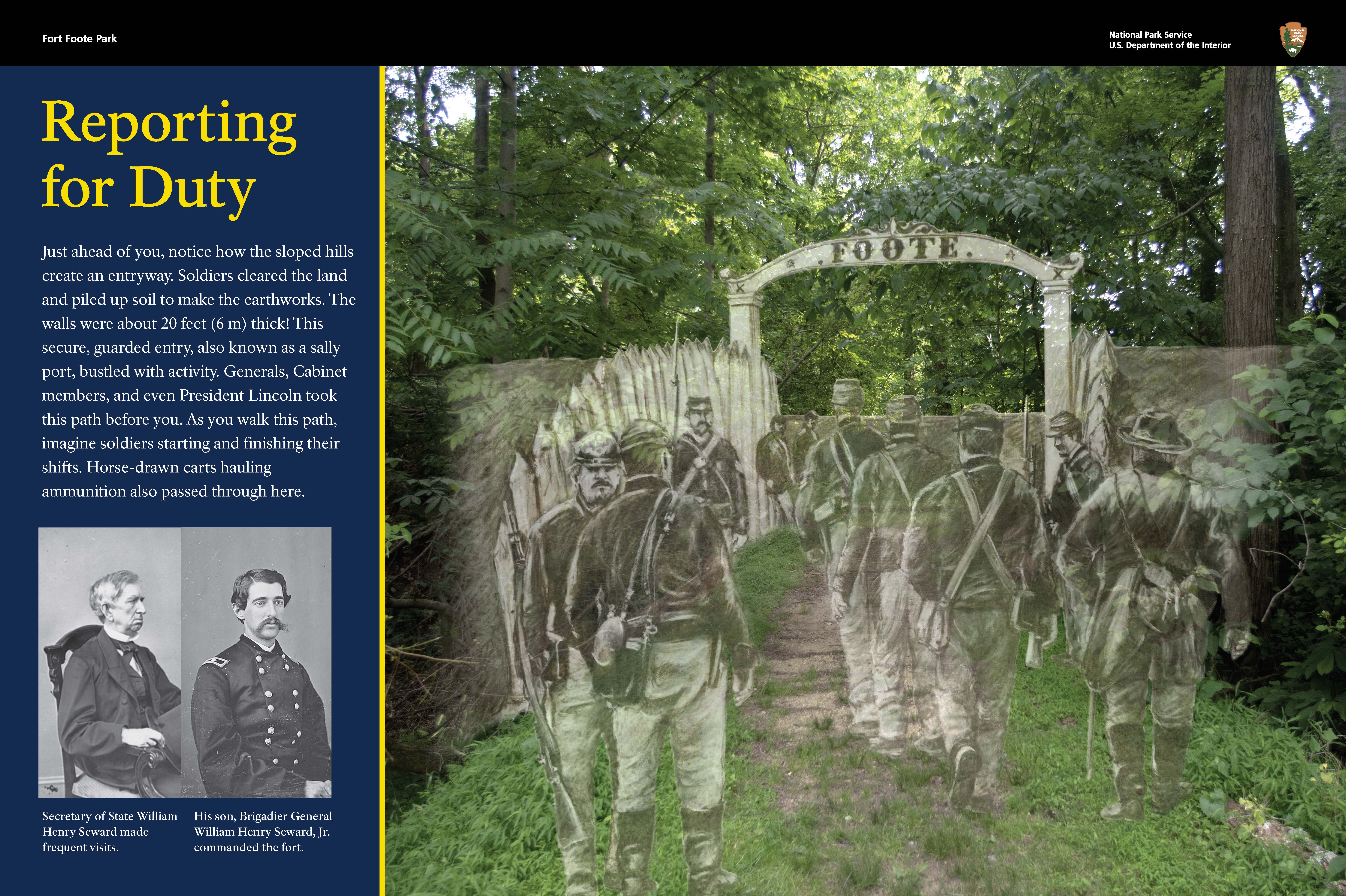
Slanted Wayside Panel: Reporting for Duty 352 words / Panel Description 2.25 minutes In front of you, is a panel 3 feet wide by 2 feet tall, and 3 feet off the ground, on dark brown painted aluminum posts. In metric, that is about 1 meter wide by a half meter tall, and about 1 meter off the ground. To the left and right of the panel, are dense trees. Ahead of you, a dirt path crosses a dry moat roughly four feet, or 1 meter, deep. The fort’s earthen walls rise on the far side of the moat, with a gap where the path enters the fort. On the right side of the panel, is a color photograph of where you are now. A pencil sketch layers a historic scene over the contemporary photograph. The sketch shows what this entrance gate would have looked like in the mid-1800s. Tall logs line the path and lead to a metal arched gate. On the top of the gate, is the word “FOOTE.” Several Union soldiers walk toward and away from you. The soldiers wear dark caps, dark coats, light pants, and dark boots. Each soldier carries two small bags across their bodies and holds a musket. On the left, is yellow and white text on a dark blue background: Reporting for Duty. Just ahead of you, notice how the sloped hills create an entryway. Soldiers cleared the land and piled up soil to make the earthworks. The walls were about 20 feet, or 6 meters, thick! This secure, guarded entry, also known as a sally port, bustled with activity. As you walk this path, imagine soldiers starting and finishing their shifts. Horse-drawn carts hauling ammunition also passed through here. End of Text Below the text, are two black and white portraits of two seated men. The man on the left is Secretary of State William Henry Seward, who made frequent visits to the fort. He has gray hair and wears a dark suit. He holds a top hat on his lap. The man on the right is his son, Brigadier General William Seward, Jr., who commanded the fort. He has dark hair and a prominent mustache. He is dressed in military uniform. [End of message]
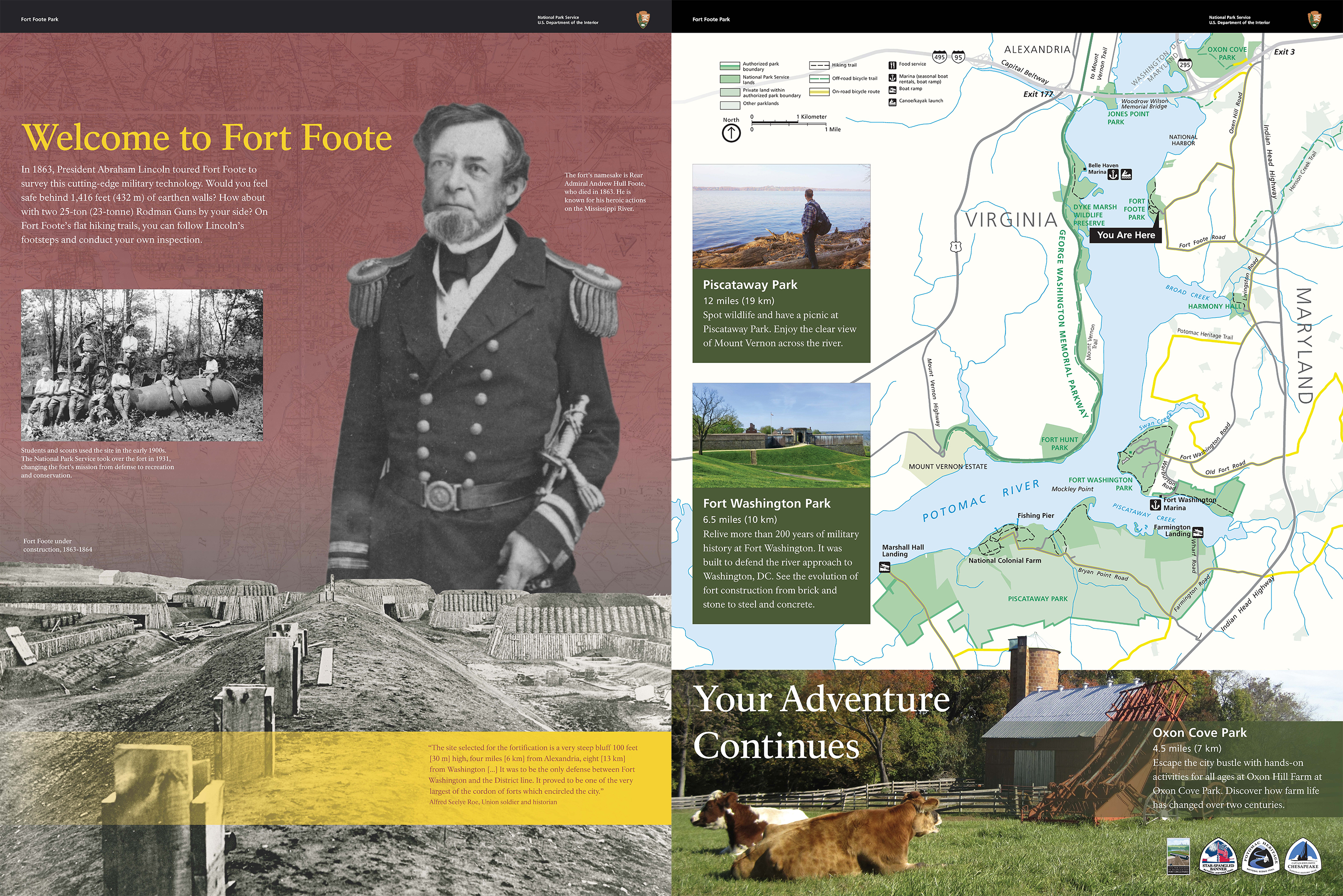
2 Upright Wayside Panels and Fort Tactile: Welcome to Fort Foote and Your Adventure Continues 619 words / Panel Description: 5.5 minutes In front of you, is a two-sided panel 3 feet wide by 4 feet tall, and 3 feet off the ground, on dark brown painted aluminum posts. Attached to the panel, is a table 3 feet wide by 1 and a half feet deep, and 3 feet off the ground. This table supports a bronze model of the fort. The panel is at the edge of the parking lot. Ahead is a dirt path, that leads to the fort. The background is a red map of Washington, DC, and the surrounding area. At the top, is the text quoted in this entry's body text, in yellow and white. Under the text, is a black-and-white photograph of 9 Boy Scouts sitting or standing on a Rodman Gun, lying in the grass. Students and scouts used the site in the early 1900s. The National Park Service took over the fort in 1931, changing the fort’s mission from defense to recreation and conservation. At the right, is a large black-and-white portrait of a standing Union Rear Admiral Andrew Hull Foote. He is bearded and dressed in military uniform, with prominent epaulettes, or decorative fringe, on his shoulders. His left arm wraps around his sword hilt. He died in 1863. He is known for his heroic actions on the Mississippi River. Across the bottom of the panel, is a black-and-white photograph of the fort under construction in 1863-1864. In the center, is a large earthen mound with wooden footings. To either side of the mound, is a flattened path. On the outer sides of the path, are earthen walls and wooden structures. Most of the structures are finished with round, earthen roofs, but some are still being built. The surrounding area is devoid of trees, unlike today. Across the bottom, is a transparent yellow banner. Within the banner, on the right, is the quote by Alfred Seelye Roe in red text. The other side of the panel is filled with a blue, green, and off-white map. Virginia is at left, Maryland is at right, and the Potomac River is in between. Washington, DC is at the top. Several National Parks Service sites are located in this region along the river. On the map, they are shaded green and labeled by name. The map shows hiking trails, off-road bicycle trails, on-road bicycle routes, food services, marinas, boat ramps, and canoe or kayak launches. Across the bottom, is a color photograph of a farm. This is Oxon Hill Farm at Oxon Cove Park, which is 4 and a half miles, or 7 kilometers, north of Fort Foote. At left, are 2 brown cows lying on green grass. In the background, at right, is a red barn with a gray roof. A red hay loader sits in front of the barn. In top left corner of the photograph, is white text: Your Adventure Continues End of Text At the right end of the photograph, is the image caption in white text on a green background. On the left side, in the middle, is a color photograph of Fort Washington Park. The fort is a gray stone and concrete building on a grassy hill. It was built on the east bank of the Potomac River. Fort Washington is 6 and a half miles, or 10 kilometers, south of Fort Foote. Under the photograph, is the image caption in white text on a green background. In the top left corner of the panel, is a color photograph of Piscataway Park. A man stands among driftwood on the banks of the Potomac River. Piscataway Park is 12 miles, or 19 kilometers, south of Fort Foote. Under the photograph, is the image caption in white text on a green background. [End of message]
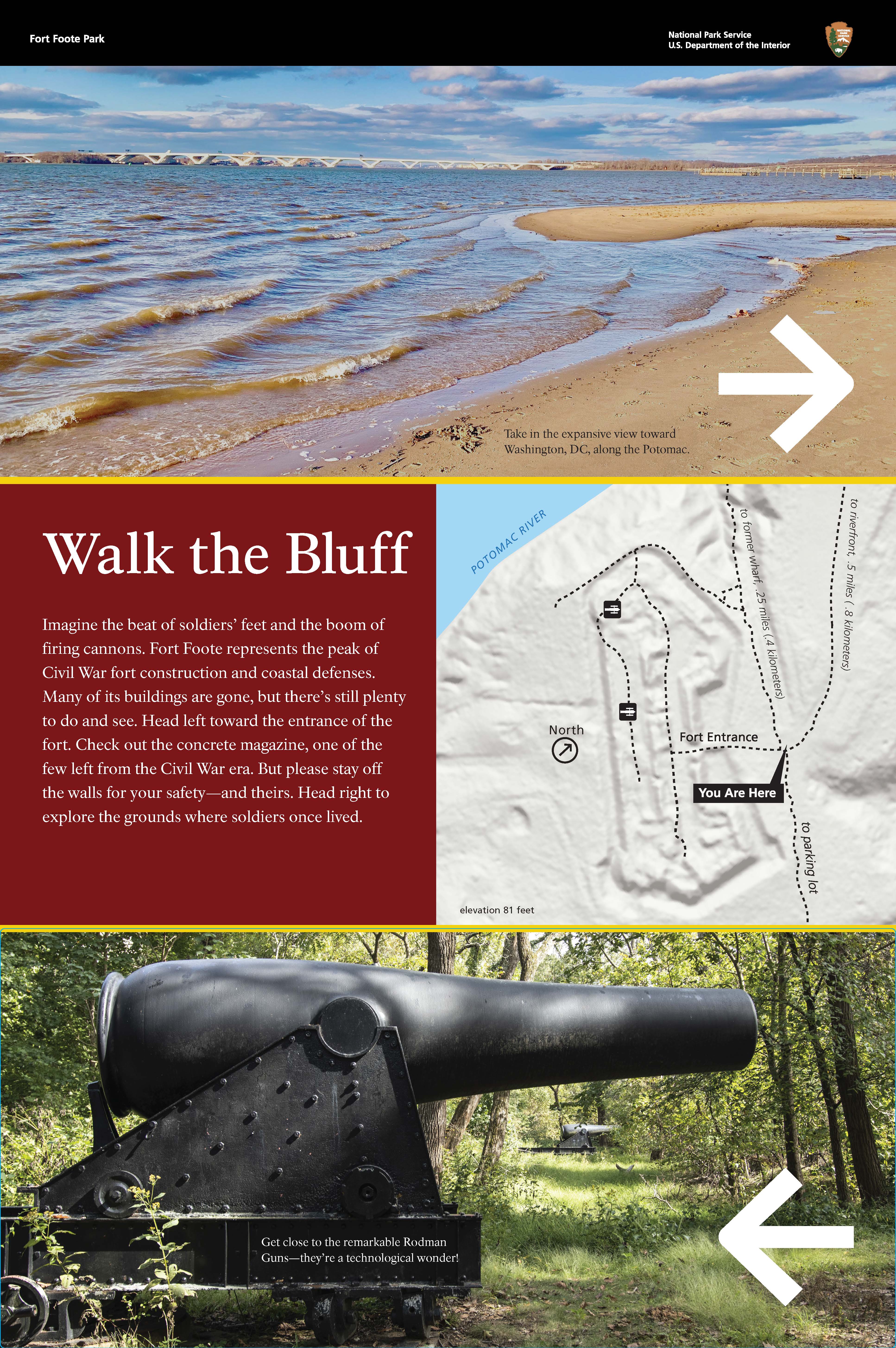
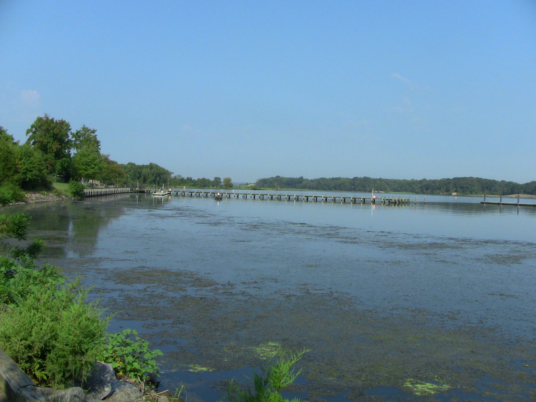
Upright Wayside Panel: Walk the Bluff 405 words / Panel Description: 2.75 minutes In front of you, is a panel 2 feet wide by 3 feet tall, and 3 feet off the ground, on dark brown painted aluminum posts. In metric, that is about a half meter wide by about 1 meter tall, and about 1 meter off the ground. The panel is in the middle of a clearing. There are tall trees around the clearing. At the top of the panel, is a color photograph of the Potomac River. In the foreground, small waves roll toward a brown sandy riverbank. In the background, a large metal bridge spans across the river. In the bottom right corner of the photograph, a white arrow points to the right. To the left of the arrow, is white text on a brown background: Take in the expansive view toward Washington, DC, along the Potomac. End of Text In the middle left side of the panel, is white text on a red background: Walk the Bluff. Imagine the beat of soldiers’ feet and the boom of firing cannons. Fort Foote represents the peak of Civil War fort construction and coastal defenses. Many of its buildings are gone, but there’s still plenty to do and see. Head left toward the entrance of the fort. Check out the concrete magazine, one of the few left from the Civil War era. But please stay off the walls for your safety and theirs. Head right to explore the grounds where soldiers once lived. End of Text To the right of the text, is a gray map with black dashed lines for the trails. The blue Potomac River runs along the left side of the map. In the middle right side of the map, is white text on a black rectangular label: You Are Here. The path to the parking lot is behind you. The path ahead and to your right leads to the riverfront, about one-half mile, or point 8 kilometers, away. The path directly ahead leads to the former wharf, about one-quarter mile, or point 4 kilometers, away. The path to the left leads you to the Fort Entrance and the Rodman Guns. At the bottom of the panel, is a color photograph of 2 black Rodman Guns in the green forest. 1 gun is in the foreground and the other is in the background. Near the base of the gun, is white text on a black background: Get close to the remarkable Rodman Guns—they’re a technological wonder! End of Text [End of message]
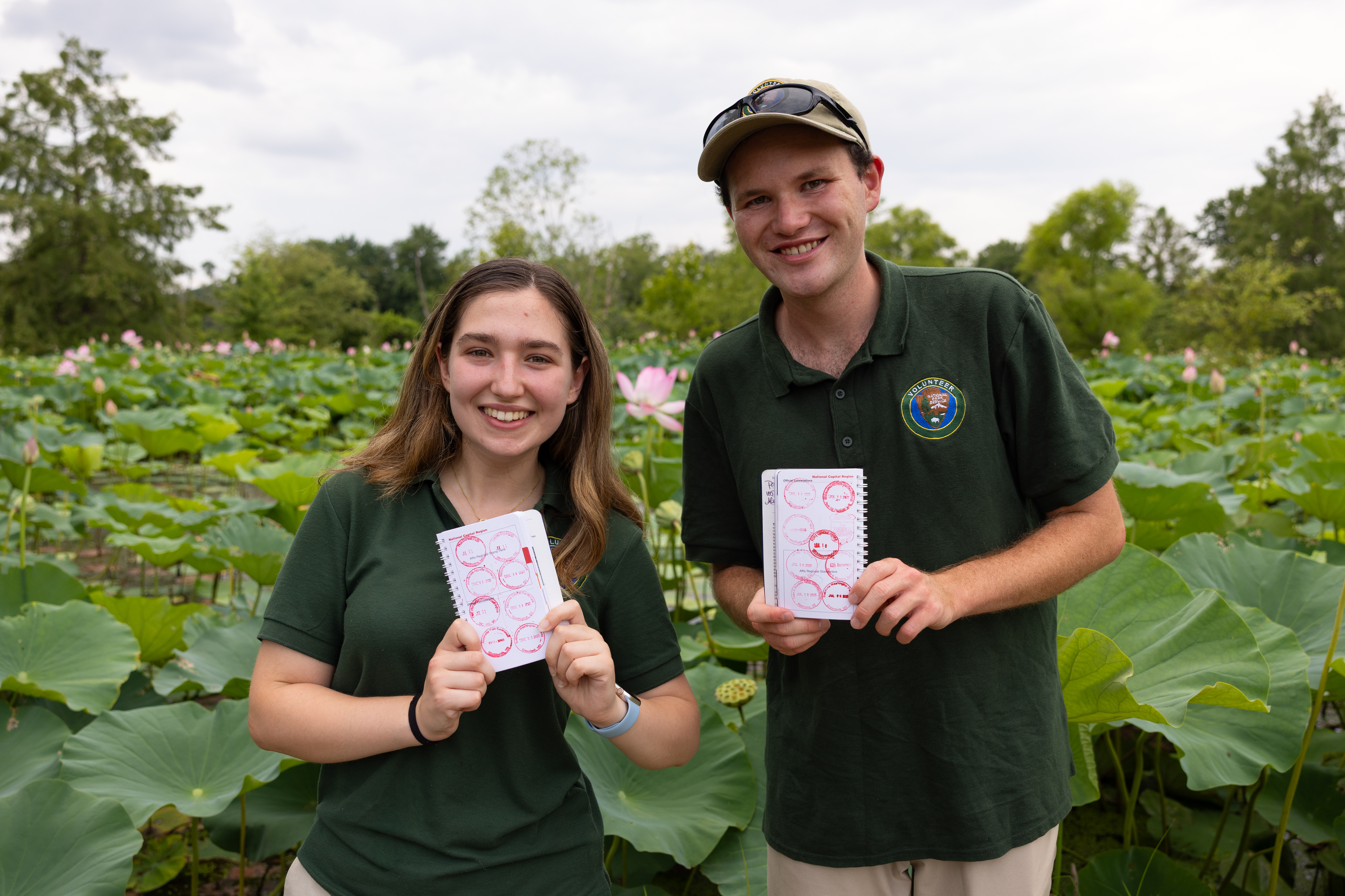
Collect all the National Capital Parks - East Passport Stamps
Start your stamp collection and celebrate every park you visit! Explore historic sites and scenic parks managed by National Capital Parks - East and collect a unique stamp at each one.
Bicycle Smallwood State Park to Oxon Cove Park
The on-road bicycling route between Smallwood State Park and Oxon Cove Park makes connections with parks and historic sites.