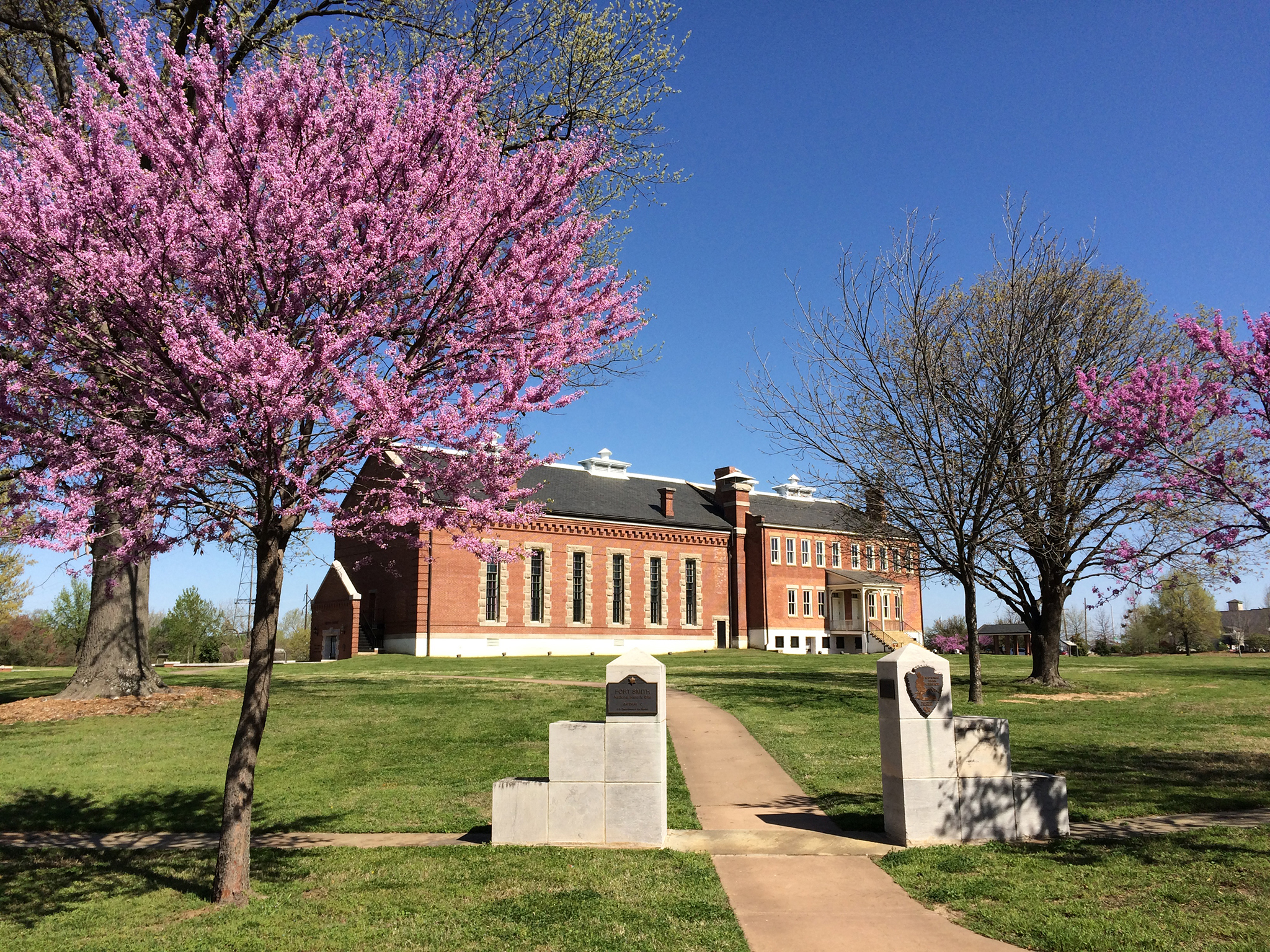
Explore life on the edge of frontier and Indian Territory through the stories of soldiers, the Trail of Tears, scandals, outlaws, and lawmen who pursued them. From the establishment of the first Fort Smith on December 25, 1817, to the final days ...
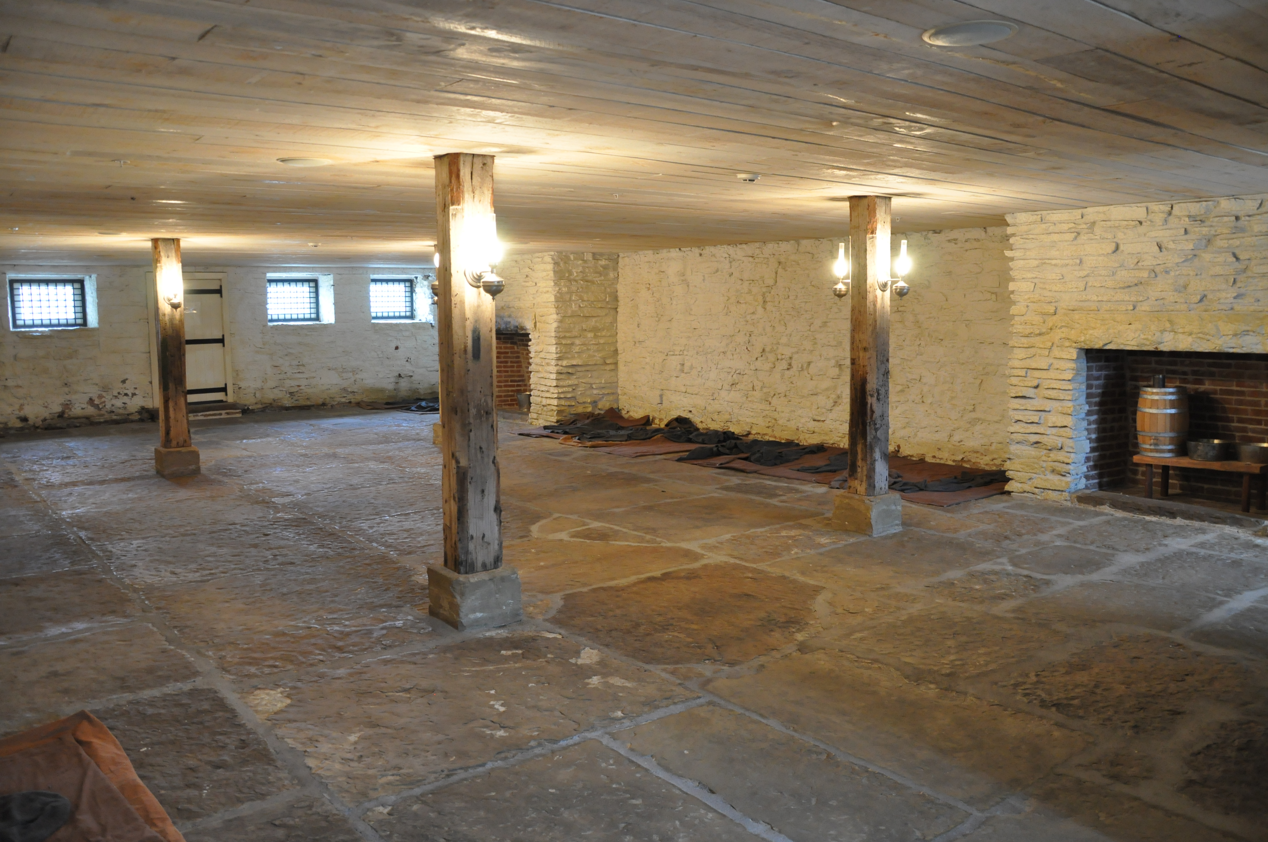
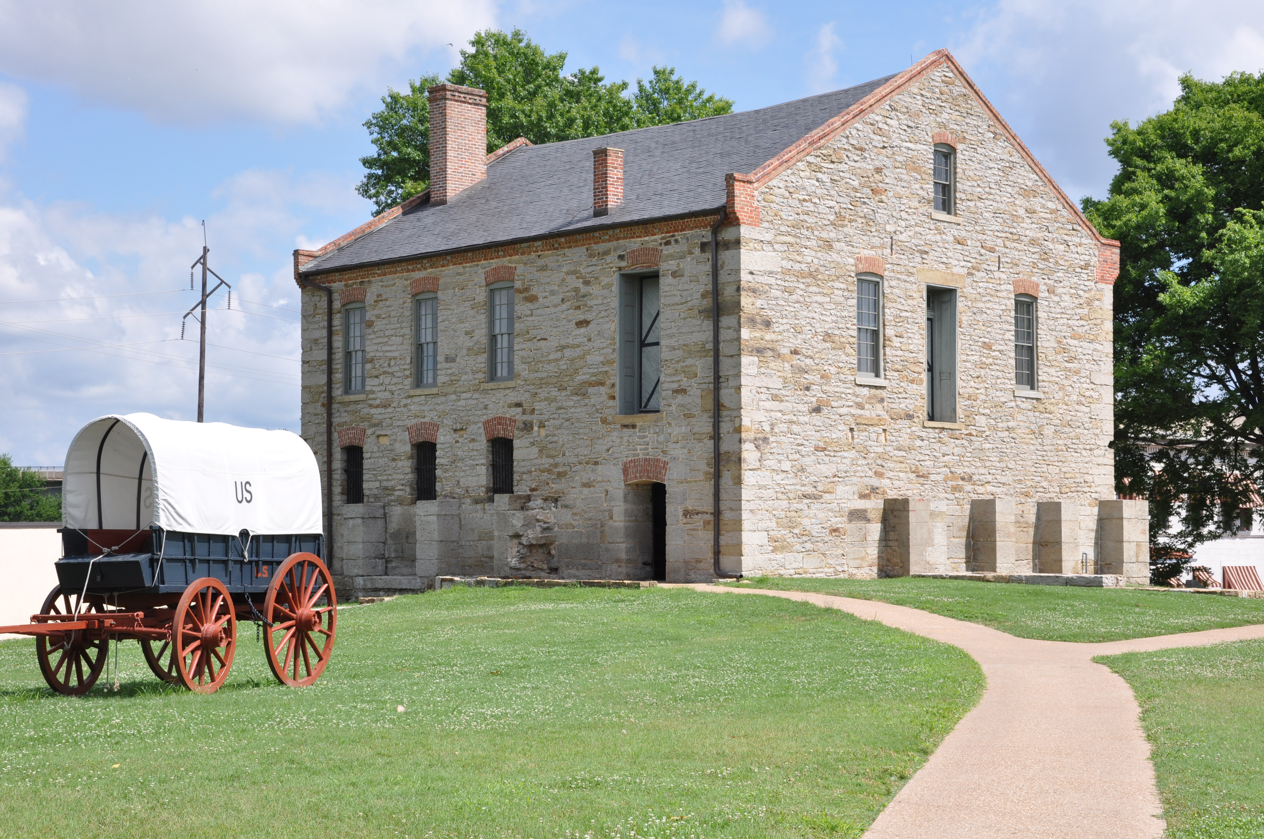
First Jail - Area Description Enter the room through an opening that was a solid wall. The jail cell is one room, about 20 feet deep and almost 40 feet wide. There's a wooden ceiling about 7 feet high and rough whitewashed brick walls. Four wooden posts in the interior hold old-fashioned brass lamps with glass globes. On the walls to the left and right ends of the room are barred windows, two on each side of a wooden door. Around the perimeter of the room on the floor along the walls are thin mats with a blanket on each to show how the inmates once slept. Two fireplaces on the wall opposite the entrance of the room display the inmates' necessities. The fireplace to the left, holds two metal pails, bathroom buckets, for body waste. There is not door to provide privacy. The fireplace to the right holds a bench with a jug of drinking water, a single tin cup, and two shallow metal pails for washing. On the wall to the right is a small cell with wooden walls and a barred metal door. Inside is a single wooden chair. The prisoner would stand at the barred door while his attorney or visitor would stand or sit in the small cell. Second Jail - Area description Second floor of the visitor center. Inside the room, are a cut away section of exposed brick and mortar rising to the ceiling. Six cells, two on each of the three level or tiers are show. Cells with bunk beds are shown on the upper floors. A life-sized figure of a jailer, with keys in his hand, stands overhead on a platform where the second tier would have been. At floor level, groups of standing panels with text and photographs are placed between the posts, with information and quotes on each side of the panels. End of Description.
After over six years, the first Fort Smith was abandoned as soldiers were ordered to push further west into Indian Territory.
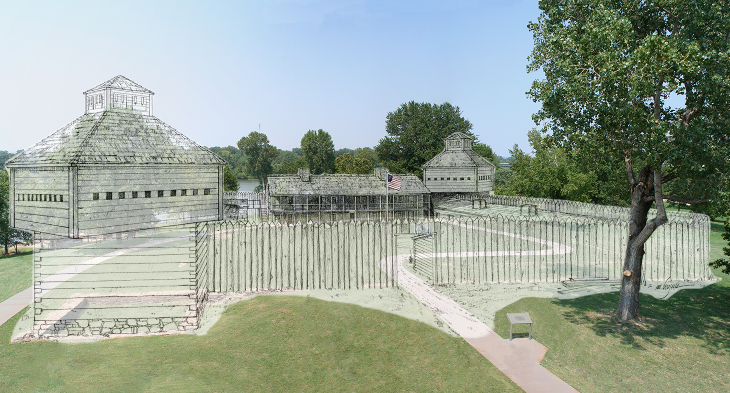
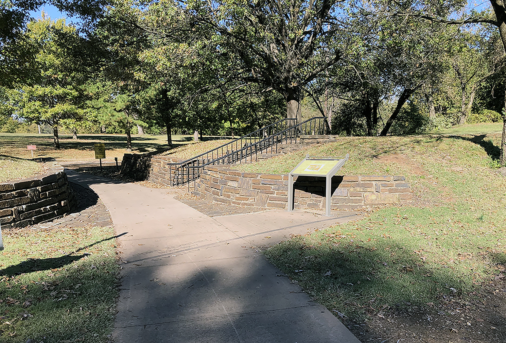
Wayside Panel: Abandoned and Forgotten. 369 words. This wayside panel is located near the southeast edge of the First Fort Smith. Only the foundations of the original fort remain today. From here, they appear as a broken line of stones set into the grass about 15 feet straight head. The line terminates to the left in a square stone enclosure about 20 feet wide by 20 feet long and a few feet deep. This was the blockhouse of the first Fort Smith. Straight ahead, beyond the fort's foundations, is a white flagpole considerably shorter than the one at the site of the Second Fort. It's topped by an American flag with 15 stars and 15 stripes. To the right of the flagpole is a replica of a 19th-century cannon. The 3½-foot by 2-foot panel presents a large color photograph of the first fort area. It shows the cement path you're standing on that leads through the site. It shows the remnants of the fort's foundations, the trees that dot the grassy expanse, and the Arkansas River in the distance. Superimposed on the photograph is a line drawing of the fort as it may have originally looked. The drawing features a tall wooden fence made of pointed logs. The fence crosses the modern cement walkway just in front of you. At the south corner, the fence ends at the block house, a two-story enclosed wooden structure with small rectangular windows. A similar building sits at the north corner, opposite it. A couple of additional buildings, along with the flagpole, are visible within the fort. Text below the image reads: "Imagine spending 5 years building a home only to abandon it. That is exactly what the first Fort Smith soldiers did. They quarried rock and shaped logs to build the fort by hand. Shortly after completing it in 1824, they were reassigned to repeat the process again at Fort Gibson (Oklahoma). "After the soldiers abandoned the fort, it was eventually lost to time where it would remain for over 120 years until its discovery by archaeologists in 1958. Based on the original stone foundation and Army plans, this is what the fort may have looked like." End of description.
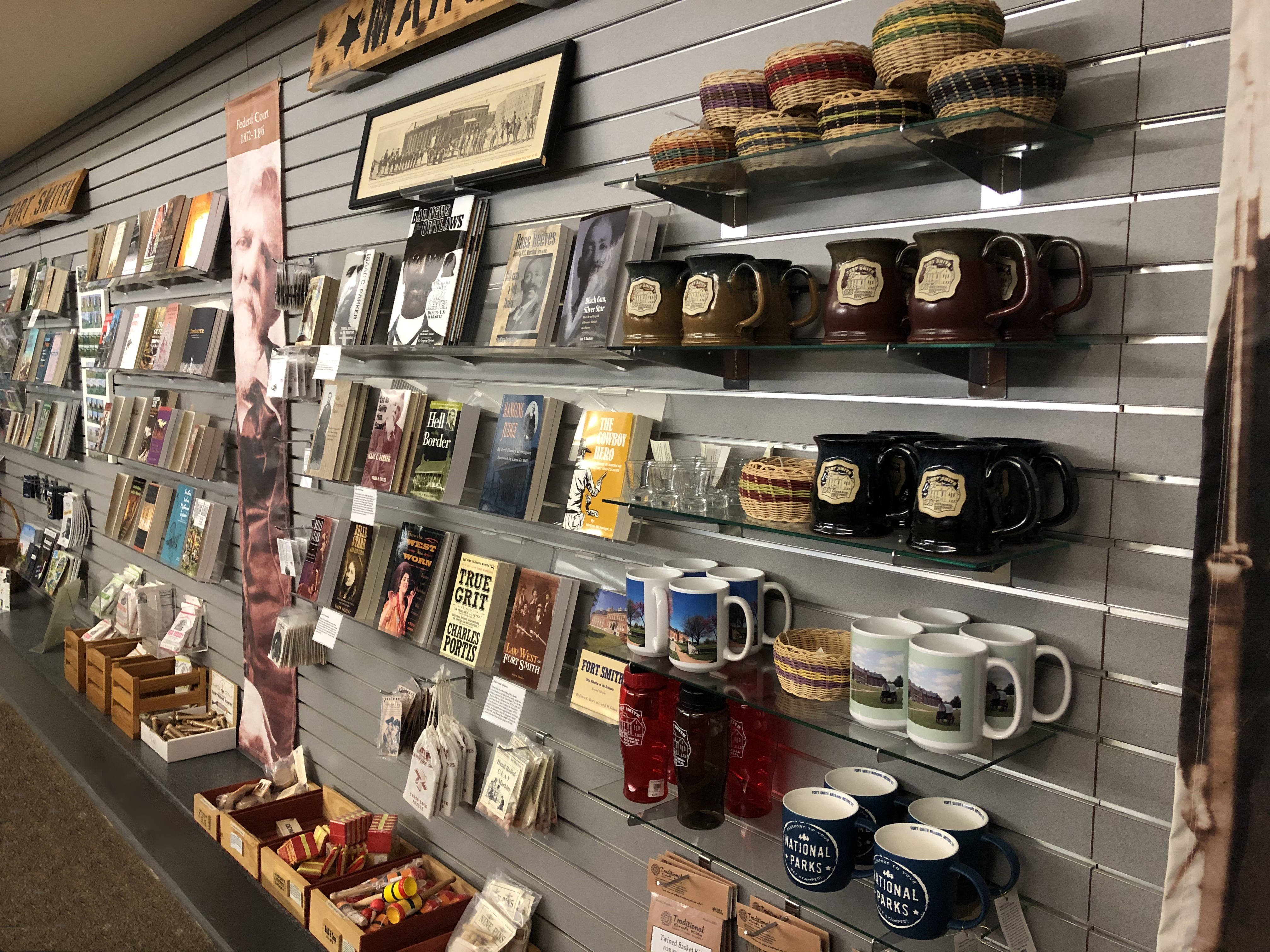
The park store is on the left side of the visitor center lobby. The walls are gray slatwall panels with shelves stocked with books, postcards, lapel pins, mugs, toys, and more. The merchandise is moved and reorganized regularly. The cash register and staff are located at information desk in the center of the lobby.
Wayside describing how the building has changed over time.
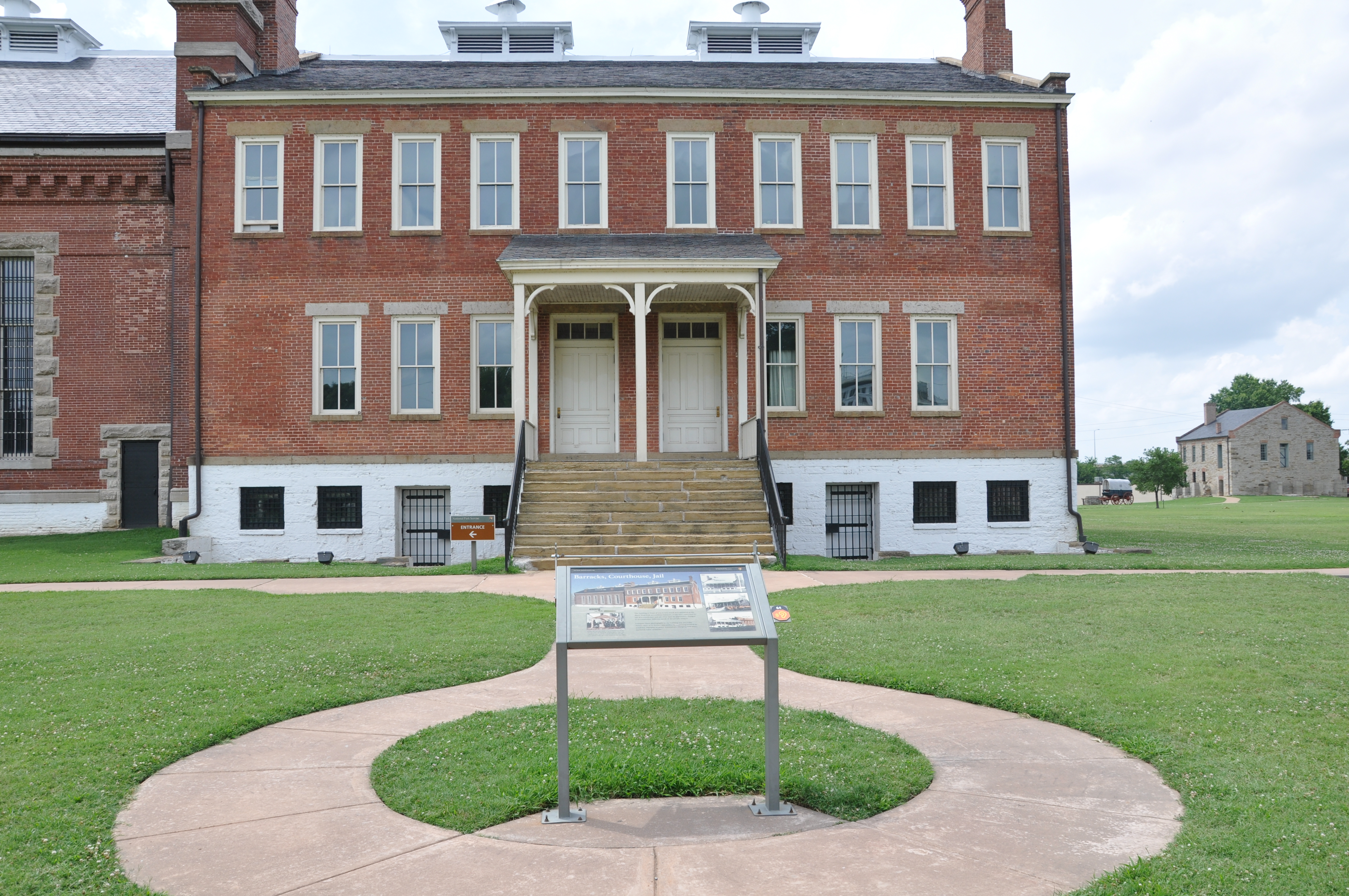
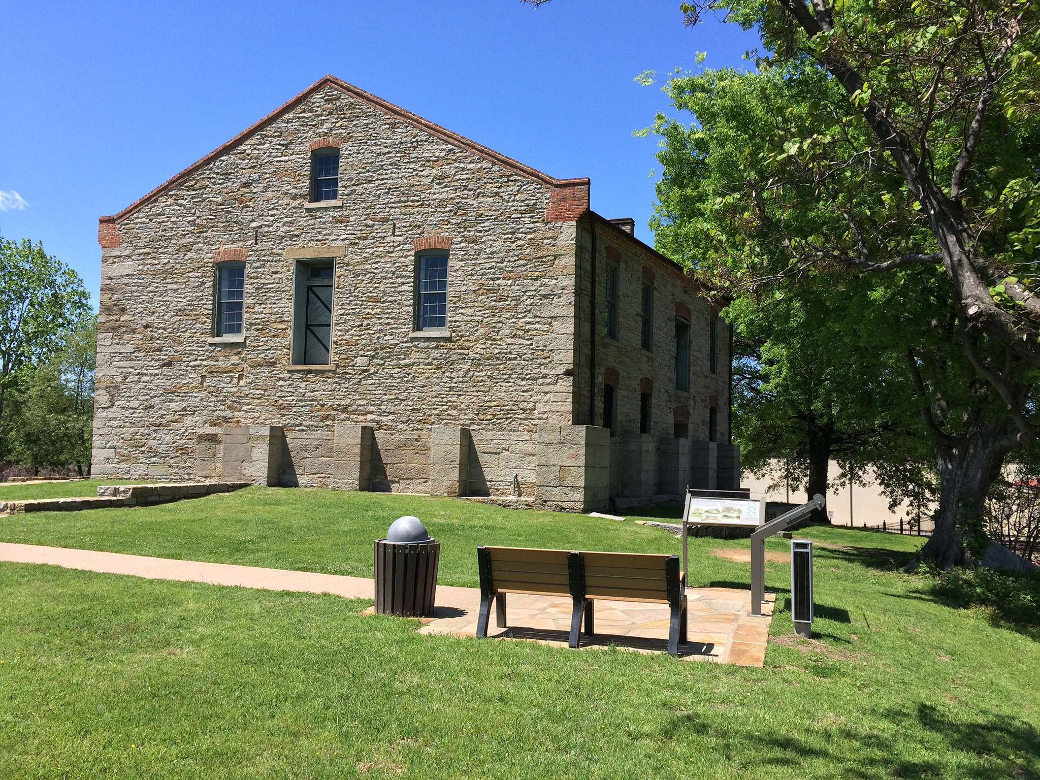
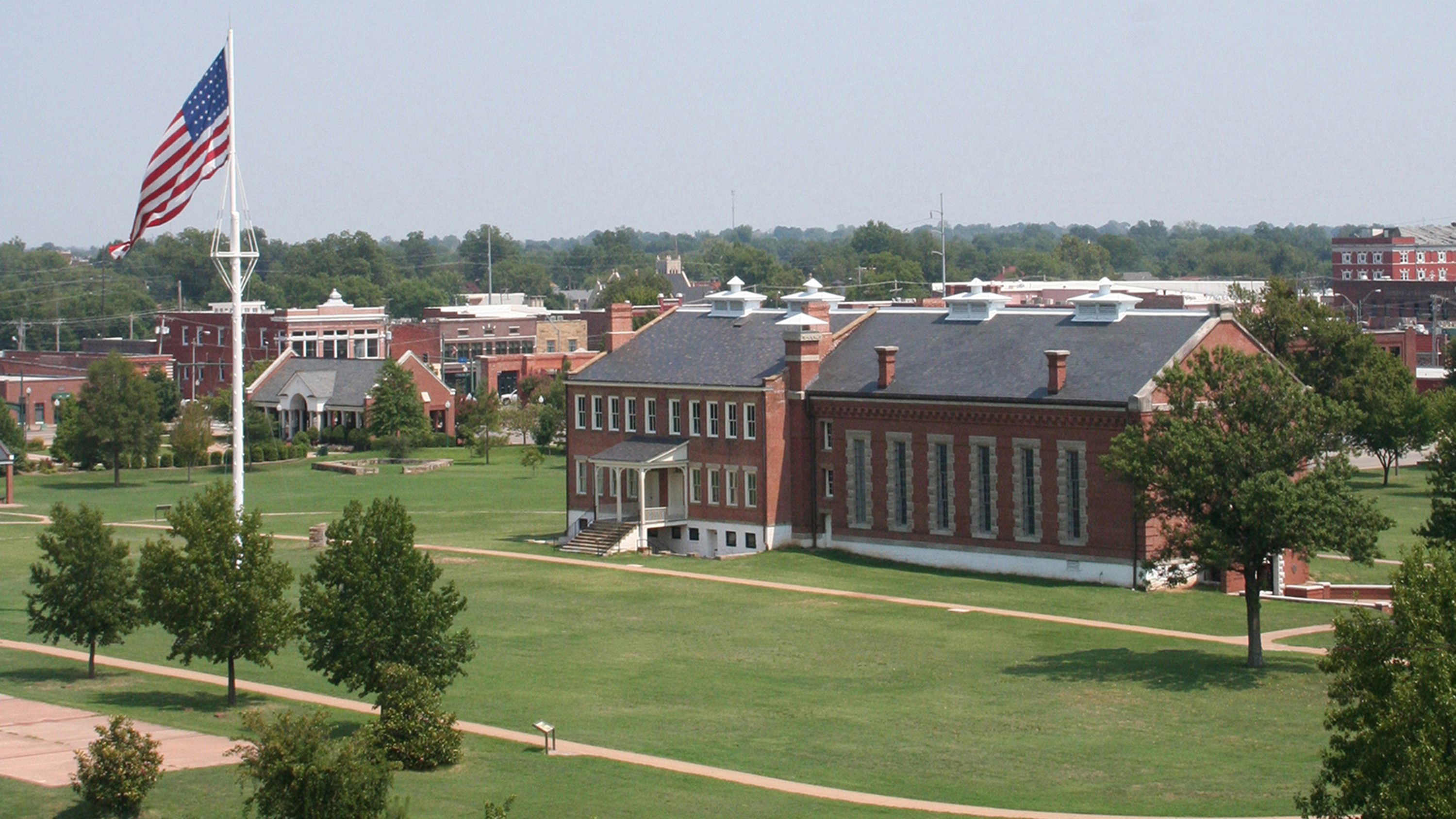
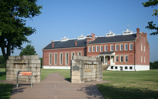
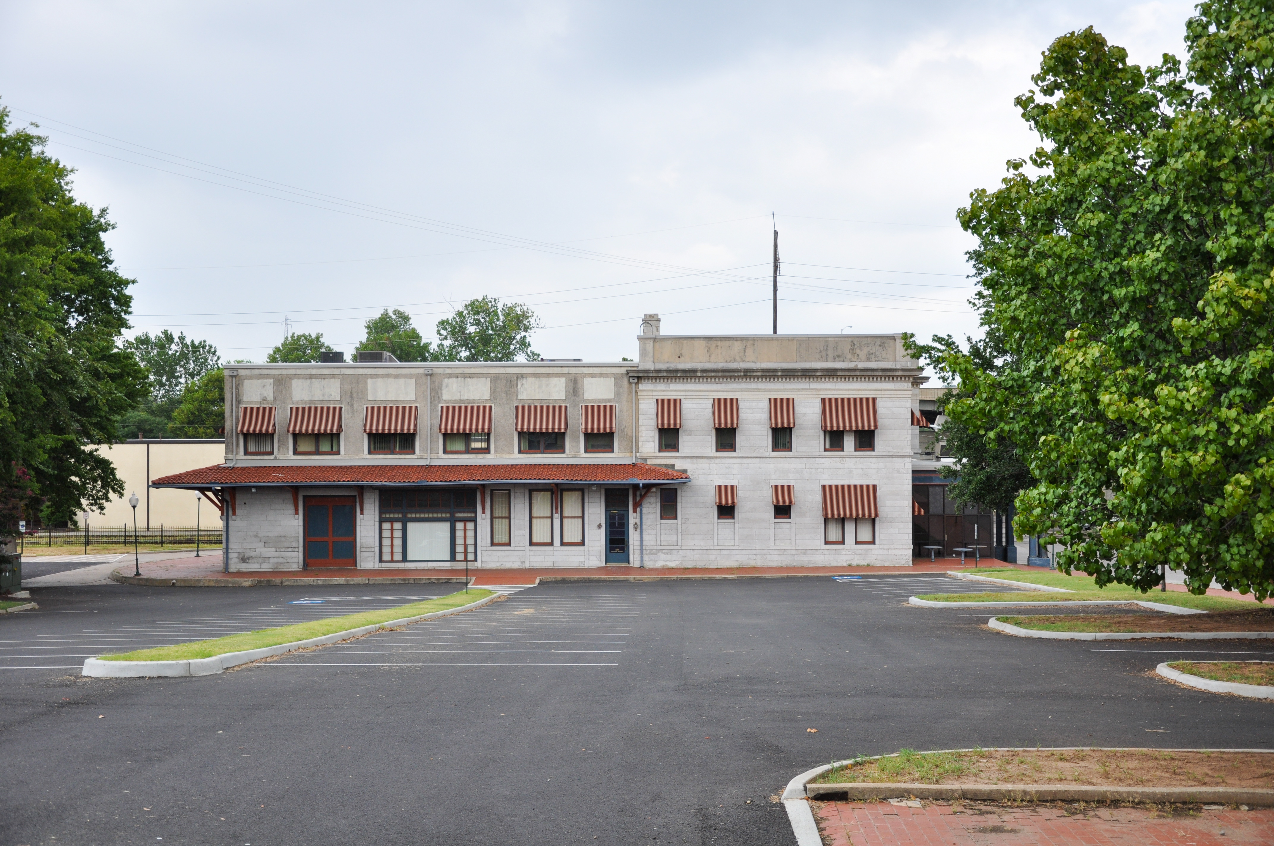
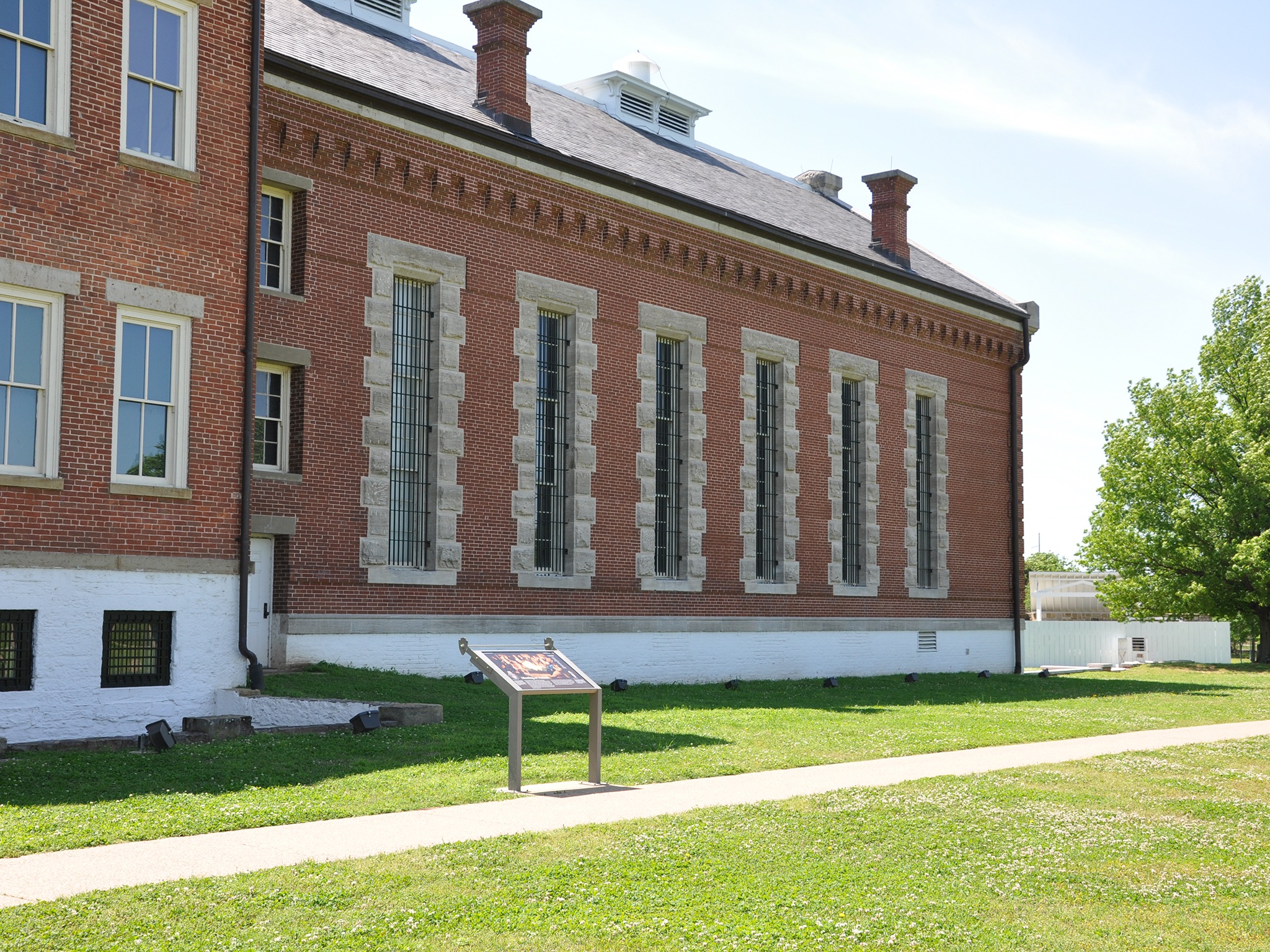
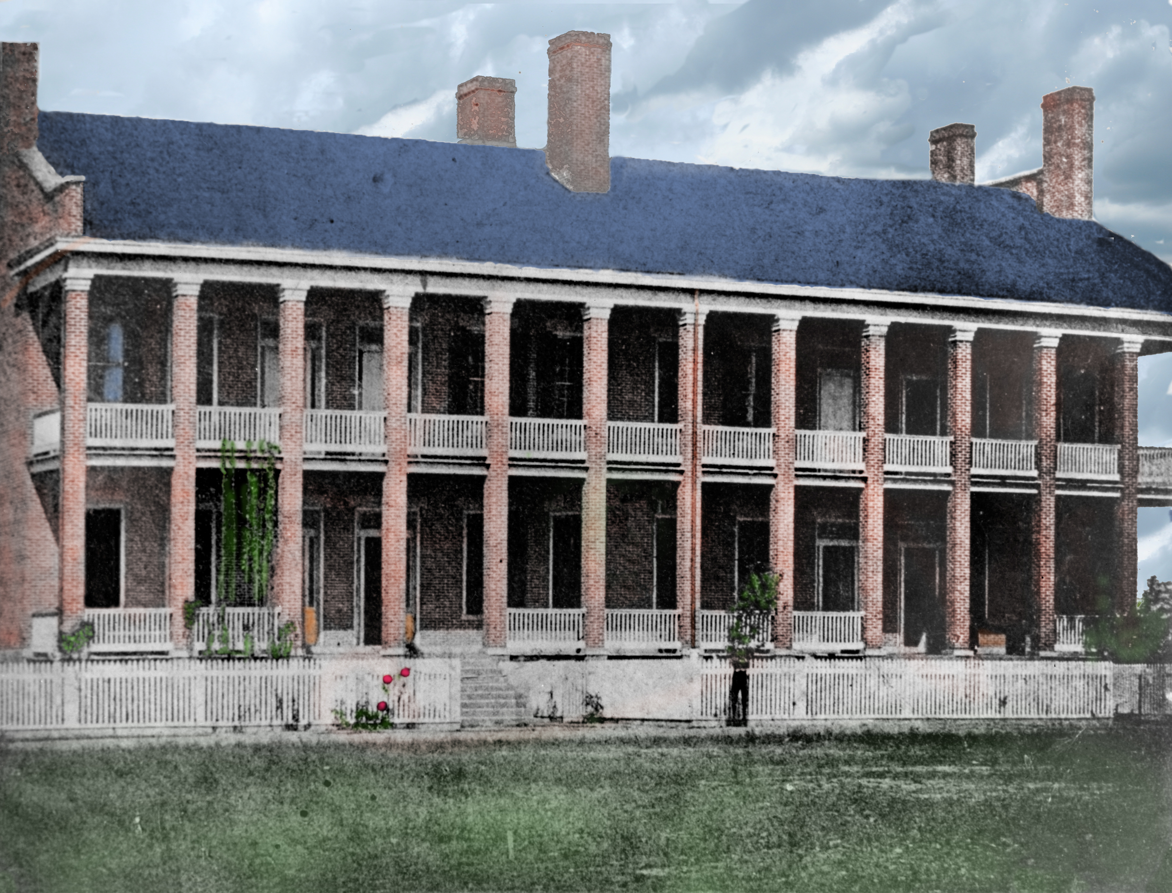
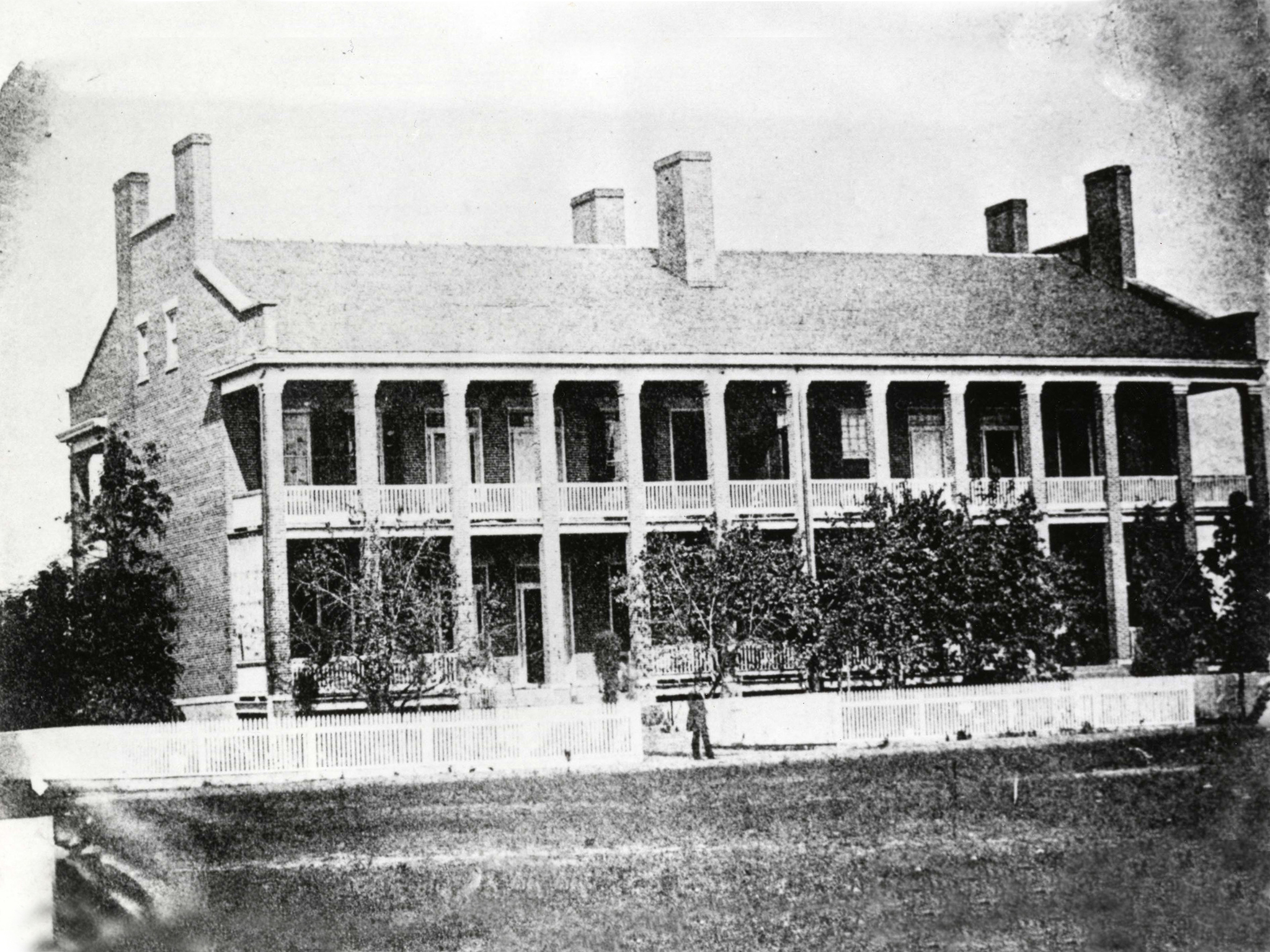
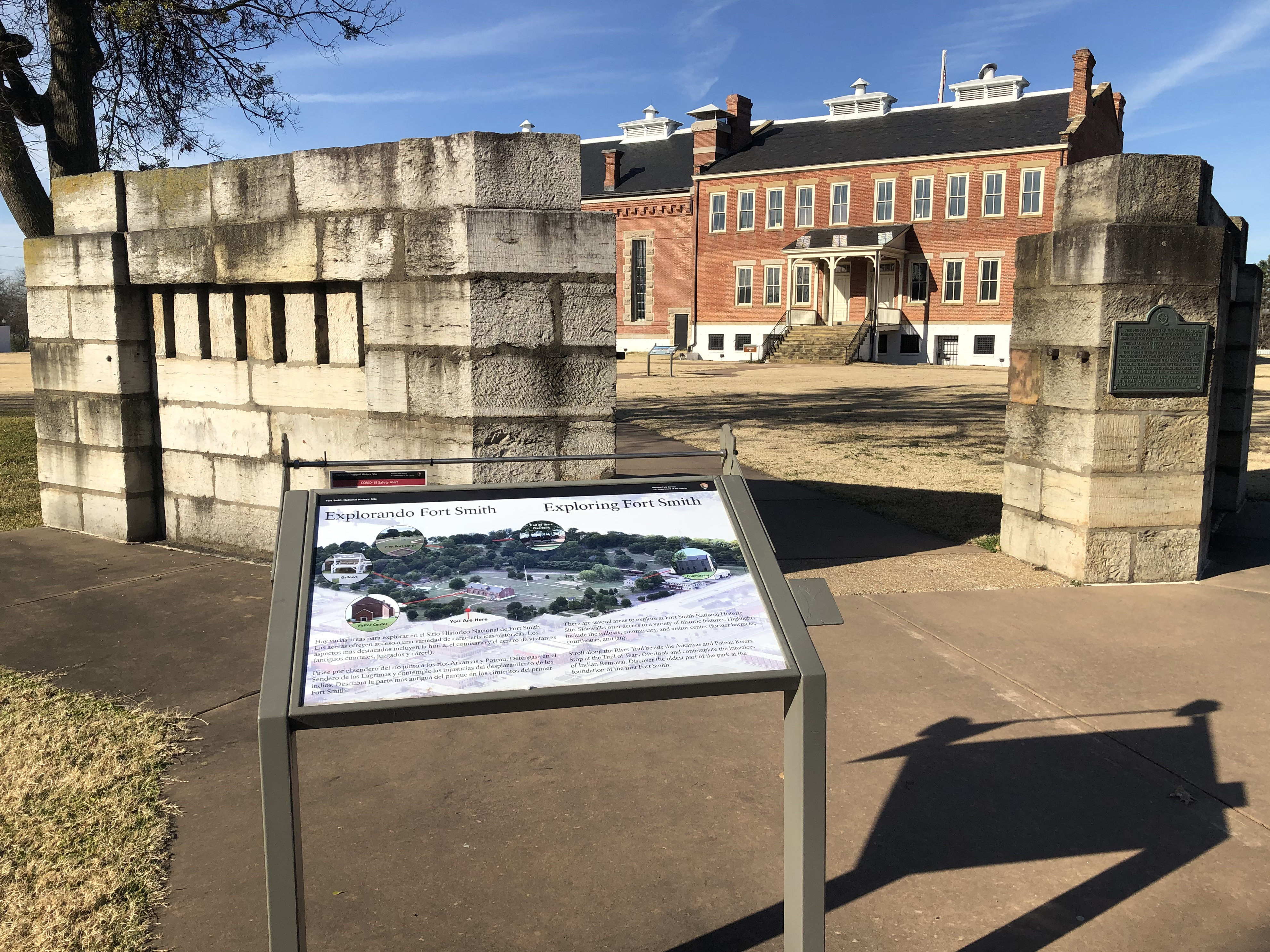
Wayside Panel: Barracks, Courthouse, Jail – Area Description. 270 words. First of two descriptions at this location. About 40 feet in front straight ahead is a long red-brick building, 2 ½ stories high and approximately 150 feet from end to end. It has served as a barracks, courthouse, and jail. These days it’s the park visitor center. It’s actually made up of two structures, both approximately the same size and shape, erected side-by-side. The right-hand structure includes a bottom floor that’s half below ground. The upper, visible half of the floor is painted white and has square, barred windows. Above that are two full stories clad in natural brick, with rectangular windows—10 windows on the top floor and 6 below that. In the middle of the façade, 10 stone steps lead up to a wooden porch. Two white doors enter the first full floor from the porch. The structure on the left features darker red brickwork, and its 6 large windows are each two stories high and covered with bars. A band of white paint also lines the bottom of this building, but it only extends up a few feet and doesn’t line up with the building to its right. The roofline begins a couple of feet below its slightly taller neighbor as well. Just below the roofline is a row of decorative brickwork. Both structures are topped with black pitched roofs. The cement path leads toward the porch, and then forks right and left around the building. The porch doors are not open to the public. The public entrance is around the side of the building to the left. Wayside Panel: Barracks, Courthouse, Jail – Panel Description. 324 words. Second of two descriptions at this location. This wayside panel shows a modern photograph of the building in front of you. Three smaller, black-and-white photos to the right of the main image depict the building in earlier periods. The text reads: “Barracks, Courthouse, Jail “The building in front of you is very much as it appeared in the 1890s. First built as a military barracks, it was later converted for use as a courthouse and jail. Over time its appearance changed to accommodate different needs of the people using it. “Compare these photographs to the building you see today. Notice clues of its former appearance by examining bricked-in windows, remnants of porch foundations, changing roof lines, and brick color variations.” End of text. In the main photo, various parts of the building are labeled. The lower level of the right-hand structure is identified as “First Jail 1872.” The first floor is labeled “Original Barracks 1851-1887,” and the top floor is labeled “Courthouse Second Floor 1891.” The left-hand side is identified as the “Second Jail 1888.” The historical photograph on the top right shows just the right half of the building without its top floor. The photo is labeled “Original Barracks 1865.” The photo below it shows the same structure in 1880. The first floor is labeled “Courthouse” and the lower level is highlighted and labeled “First Jail.” The bottom photo, from 1888, shows the same structure, again labeled “Courthouse,” but now the second building appears next to it, identified as “Second Jail.” An additional historical photo on the bottom left shows a small gazebo in front of the building. Text reads: “Under the circular patch of grass before you is the site of a well. Sheltered by a small gazebo, this well supplied water until the courthouse and new jail were added to the city water system in the late 1880s.” End of description.
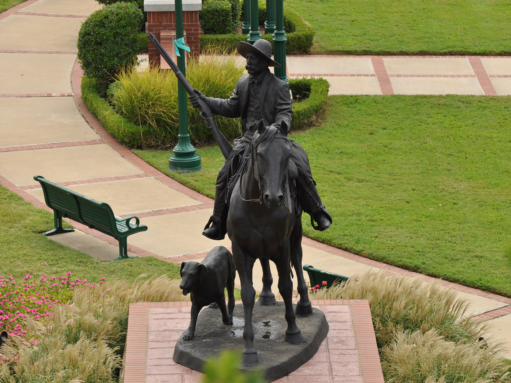
Statue of Deputy US Marshal Bass Reeves, located in Ross Pendergraft Park.
Bass Reeves Statue. 251 Words. You're at the north edge of Ross Pendergraft Park-a small urban park featuring grassy patches, crisscrossing paths, park benches, and a few trees and flowers. A larger-than-life bronze statue on this spot depicts U.S. Deputy Marshal Bass Reeves. The sculpture rests on a pedestal about four feet high, made of light-brown, rough-hewn stones and topped with several rows of red brick. The statue itself rises another ten feet or so above the pedestal. The charcoal-colored sculpture depicts Reeves astride his horse. He sits up straight in the saddle, holding the reins in his left hand and balancing his rifle in his right. The butt of the rifle rests on his thigh with the barrel pointing up to the sky. Reeves wears a wide-brimmed hat with a rounded top and looks right, off into the distance. A dog scampers along on the horse's right flank, mouth slightly agape. The sculpture faces west, toward the Indian Territory. In fact, a concrete plaque set at a slight angle into the western face of the pedestal identifies the title of the artwork as "Into the Territories." The text goes on: "Sculptor: Harold T. Holden, Dedicated May 26th, 2012, Guest Reddick Architects." A flower bed surrounds the pedestal, with yellow, pink, and purple flowers that blossom in the spring and summer. Just to the north, a low stone wall about two feet high and 30 feet long separates the statue from the sidewalk that runs along Garrison Avenue. End of description.
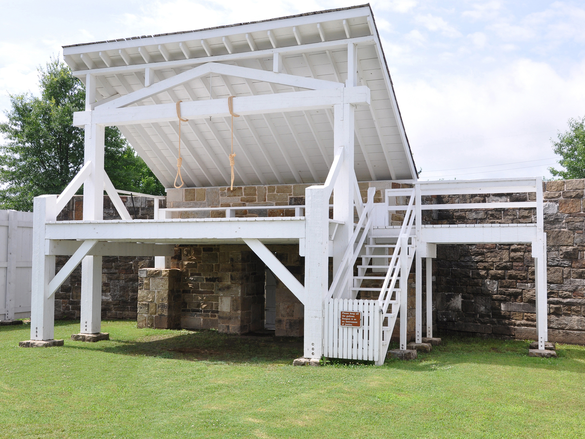
Bastion #3. 185 words. This is the former site of Bastion #3, one of five pentagon-shaped enclosures that originally stood along the wall surrounding Fort Smith. The bastion and fort wall no longer exist. Today, a low stone wall about a foot-and-a-half high and a foot-wide traces the footprint of the bastion. The low bench-like wall has a flat, grey stone top. Along its base, on the outside, several flat stones stick up from the grass. So be careful when walking around the bastion. A three-foot opening in the eastern side of the low bastion wall allows access into the enclosure. The bastion is about 20 feet long and 15 feet across at its widest point. On its northeast edge it abuts the reconstructed gallows. There, the low, re-created bastion wall merges with a much taller stone wall that forms the back support for the gallows. A small white wooden door is cut into the center of the wall. It once provided access into the gallows enclosure, but it no longer opens. The shingled roof of the gallows sticks up above the support wall.
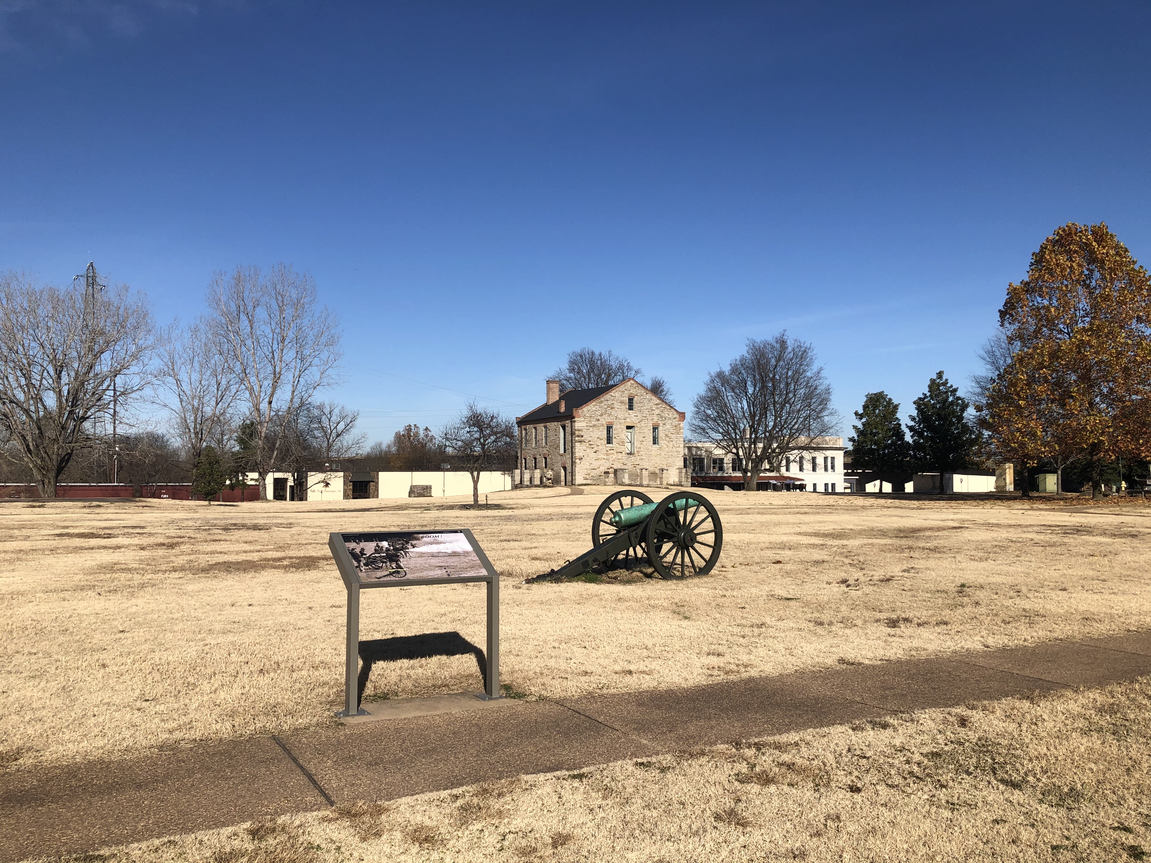
This cannon is a replica of one of the cannons left by the military when they abandoned Fort Smith in 1871.
Wayside Panel: Boom Area Description 96 words. First of two descriptions at this location. The wayside panel is located at the northeastern end of the parade ground just inside the oval cement walkway that surrounds it. When facing the wayside, a replica 12-lb Napoleon cannon is ten feet diagonally at approximately 2:00 on a clock-face. The metallic-green barrel sits on a frame supported by two large spoked wheels. One hundred feet across the parade ground and slightly to the right is the light brown stone with gray pitched roof commissary. The guardhouse is fifty feet to the right. Panel description 497 words. Second of two descriptions at this location. This wayside panel is titled “Boom!” It’s about 3 ½ feet wide and 2 feet deep and stands about 2 ½ feet off the ground on thin metal legs. The panel’s single background image is a sepia tone modern photograph of civil war reenactors. Over 30 men in union uniforms surround five cannons in line vertically on the left third of the image. The top three cannons are in different stages of being reloaded. Smoke is shooting out of the barrel of the second cannon while the nearest cannon has yet to be fired. Text on the right half of the panel Cannons were the most powerful and feared weapons of the Civil War. Their ability to fire long distances ensured heavy enemy casualties. The Napoleon, a preferred cannon for both the North and South, allowed artillerymen to shoot a 12-pound cannonball a distance of nearly a mile with reasonable accuracy. It was one of the deadliest killing machines of its time. For the unfortunate soldiers on the receiving end of the Napoleon, its loud explosive BOOM meant terror and destruction. For many, it also meant that they had just seconds left to live. Below the main text illustrations and text Types of Cannon Rounds Illustration a solid round ball strapped to a wooden support. Text reads Round Shot (cannonball): Round shot was a solid piece of spherical metal. This was used for shooting long distance or destroying buildings. Illustration a hallow sphere filled with powder, and smaller round balls connected to a wooden support. Text reads Case Shot: Invented by Major General Henry Shrapnel in 1784, case shot exploded while in the air, raining down hot pieces of metal and lead balls in all directions. Illustration gray cylinder filled smaller gray balls on a wooden support. Text reads Canister: Canister was used when firing at soldiers less than 400 yards away. At times, cannoneers loaded two rounds of canister making it truly devastating. Photo credit text in bottom right-hand corner reads Photo: Stones River National Military Park Lower left of the panel is an illustration of a cannon with the following parts labeled. Text reads Handspike Handles Wheel guard plate Prolonge Hooks Stock 1. Lock chain bolt, eye plate 2. Part of the lock chain 3. Sponge and rammer stop 4. Sponge chain hasp 5. Ear plate for sponge chain hasp 6. Ear plate to support worm 7. Elevating screw 8. Washer hook for handspike 9. Linstock socket 10. Cap square chain 11. Cap square 12. Trunnion plate 13. Hand spike ring 14. Sponge hook 15. Axle tree Handspike Handles Wheel guard plate Prolonge Hooks Stock Cheek Cannon Barrel Spoke Fellow Tire The Napoleon cannon was named after Emperor Napoleon III (nephew of Napoleon I) who commissioned its use in 1853. The cannon at Fort Smith is a replica of the original Napoleon left behind when the second Fort Smith was abandoned in 1871. End of discription.
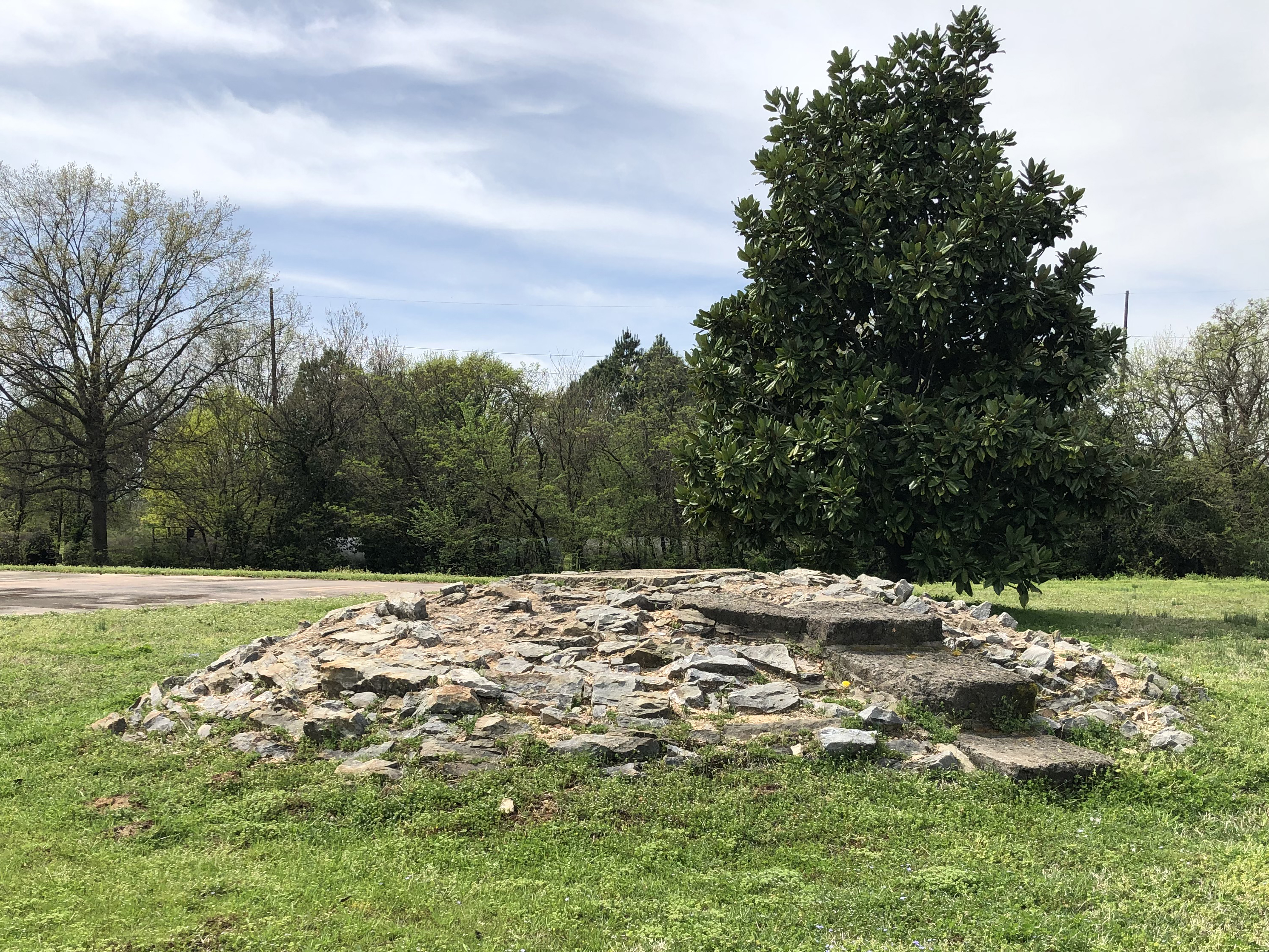
In 1869, the U.S. Army constructed a dome-shaped cistern (underground storage tank) next to the officers' quarters to make life easier. This allowed them to collect rain water from gutters installed on the roof.
Cistern. 190 words. An original cistern from the Second Fort Smith era is located along the northwestern edge of the Parade Ground, between the reconstructed foundations of the two officers' quarters. You'll find it about 20 feet outside the oval walkway that rings the Parade Ground. The cistern appears as a rough mound of grey stones held together by brown mortar. It's about 10 feet in diameter and rises a few feet above the surrounding grass. Three crude, dark grey steps are set into the cistern on its north side. They lead up to a cement square on top of the mound, about 1½ by 1½ feet in size. On the south side, about ¾ of the way up the mound, a one-foot hole opens to the hollow space below. The storage tank below is 22 feet deep. As you face the cistern from the Parade Ground, the Fort Smith flagstaff and visitor center building are both located directly behind you. About 80 feet to your left along the oval walkway is a wayside panel that provides information about the cistern and officers' quarters. End of description.
Area description and two wayside 671 words. Two panels approximately 3 ½ feet by 2 feet and 2 ½ feet high are on the west and north sides of the flagstone rectangle. On the east side is a park bench and trash receptacle. The commissary is approximately 30 feet to the west. The Frisco Train Depot is 100 feet north west of this location Wayside Panel – A building worth saving. Text and images are displayed against a close-up photo of the rough, grey stone façade of the Commissary building. Along the top, text reads: “The Commissary, one of the city’s most iconic landmarks, is the oldest building in Fort Smith. Its foundation was originally a raised platform from which to shoot cannons for defending the fort. The two-story building you see today was built on that foundation by the military in 1846 for food storage.” “Over the years, the building has served many purposes including a barracks for troops, federal court offices, a private residence, and the city’s first museum of history. Today the Commissary stands as a testament of the public’s dedication to preserving history.” End of text. Below the main text are reproductions of five historical postcards, displayed in an overlapping fashion. The postcards—4 color, 1 black-and-white—show the building from different angles and in different periods. In some of the images, a thick blanket of ivy covers parts of the Commissary’s exterior walls. Some pictures show the building with a variety of secondary structures, like porches or ramps. These secondary structures are shown more clearly in a series of three line drawings along the right-hand side of the panel. Each drawing depicts the Commissary building from the south. The top picture is labeled 1849-1866. It shows a narrow stairway climbing the southeastern wall of the building to a second-floor doorway. The second picture is labeled 1866-1886. Here, the previous stairway is gone. Now a new staircase leads up to a large porch that runs the entire length of the southwest side of the building. In the final picture, dated 1886-1896, the staircase is still there, but the porch only takes up half of the building’s southwestern wall. Text below the images reads: “The Commissary would have been demolished in 1909 had a local group of women not stepped in to save it. They successfully persuaded city leaders and local citizens to get involved in preserving the city’s heritage and historic places. Is there a building in your community that you can help preserve?” End of text. Wayside Frisco Train Depot. Background Image: Artist color illustration at night of a small crowd of people and children and two horse drawn carriages gather in front of a two story white stone train depot building with ornate columns. A porch roof juts out of the right side of the building. Just to the right of the building a black steam engine bellowing black smoke pulls up to the depot. A red caboose with a man leaning out the door is visible two tracks on the right edge of the image. Text in the upper right corner reads. “Before automobiles or airplanes, trains were the popular way to travel. At speeds of up to 65 mph (105 km), people traveled faster and farther than ever before. Besides visiting family and friends, trains took people to new and exotic places for the first time. Popular destinations included National Parks such as Yellowstone, Yosemite, and the Grand Canyon. Vital to every railroad’s success were its depots. Strategically located for fueling, communications (telegraph and mail), and receiving both passengers and freight, depots were responsible for the establishment of many new communities across the nation. Today, trains still continue to play an important role in the transportation of people and freight. Horses, trains, automobiles, and planes - what do you think comes next?” Text in the lower left corner reads. “The depot’s original columns were removed in the 1970s during the bridge expansion project.” Text in the bottom right corner reads “Night Train on the Frisco by Fort Smith artist John Bell Jr.”
Courtroom 273 words. The courtroom has 9 tall windows with green curtains along three walls. The large room is divided roughly in half by a 30-inch-tall wooden rail barrier. The left (west) side of the room has wall to wall gray and dark red flowered carpet covering the wood floor. In the left corner is a double wide wooden exterior door. A standard width wood in door on the interior wall. In front of the exterior door in the corner is a single wood chair and a 5-gallon faded red antique metal cylindrical water jug. A period pendulum clock is mounted on the interorbit wall above two rows of pale brown wooden cane backed jury chairs. In the centered on the left exterior wall is a brown stained wooden large judge’s desk on a raised platform with a cushioned high back chairs and bookshelves behind it. On the left in of the desk a single medium brown wooden witness chair. To the right is a smaller clerk’s desk. Two globe lamps on the desk and the chandelier light this side of the room. A small dark brown wood evidence table is centered in front of the judge’s desk. Two eight-foot tables covered with green felt tablecloths face each other at an angle. Law books and papers are scattered on top and two wooden chairs for attorneys are ate each table. A fireplace is centered on the far (northern) exterior wall. Above the mantle is a portrait of President Chester A. Arthur with mutton-chop sideburns extending to his full mustache. Two chairs are along the wall between the fireplace and rail. End of description.
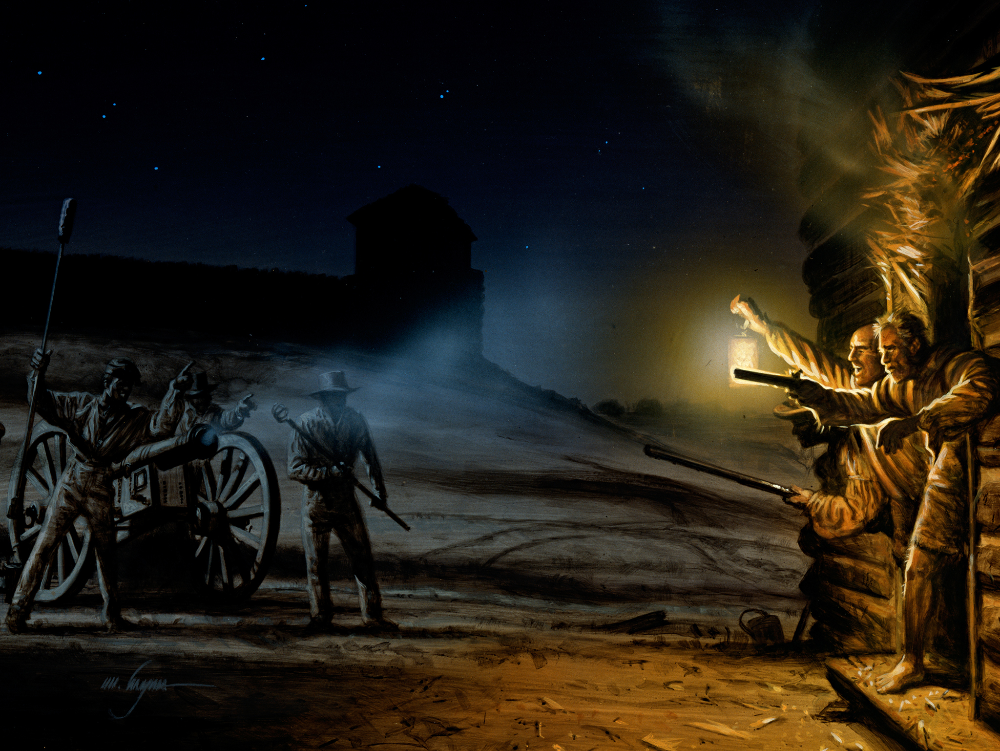
On July 31, 1864, cannon fire came down upon Fort Smith from across the Poteau River.
Wayside panel: Defending Fort Smith. Two minutes. You're facing south. Directly in front of you, about 30 feet ahead, is a small stand of roughly a dozen narrow pine trees. Beyond the trees, the ground slopes down sharply to the edge of the Poteau River. The river flows north, directly toward you, then past the trees to the right. It intersects with the Arkansas River further off to your right. The wayside panel shows a historical recreation of nearly the same view, painted realistically in full color. The image takes up the entire 36 inch by 24 inch panel. In the picture, five Union soldiers, dressed in blue, man a shiny brass cannon pointed across the Poteau River. They are pictured from behind, standing in a clearing littered with a few stumps. It's where the pine trees stand today. A yellow flash and white smoke on the far bank of the river suggest the soldiers have just fired a volley. The text on the panel reads: Defending Fort Smith. Fort Smith was fired on only once during the Civil War. On July 31, 1864, Confederates staged a diversionary attack from across the Poteau River, hoping to capture the city of Fort Smith. Their strategy was to pull Union troops away from other city locations that they planned to attack. With one small cannon and a few Creek Cherokee sharpshooters, the Confederate plan worked. Union troops responded with overwhelming firepower. "The Confederates failed to take the city, but they did drive thousands of refugees, shattered families, and runaway slaves into its already overcrowded fort. This taxed the Union's ability to feed and house the soldiers and civilians."
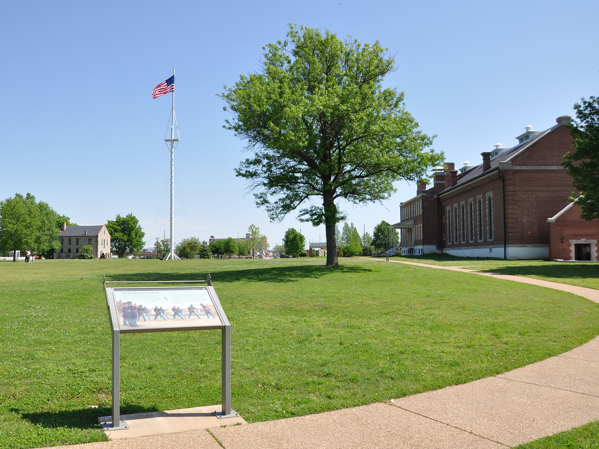
Shortly after Fort Smith was recaptured by the Union in 1863, the 11th Regiment, United States Colored Troops (USCT) were recruited out of Fort Smith.
Wayside Panel: Defending Freedom - Area Description. 1 ¼ minute. First of two descriptions at this location. This wayside panel is located at the southern end of the Fort Smith Parade Ground, just inside the oval cement walkway that surrounds it. The flagpole stands about 200 feet straight ahead, in the middle of the flat, open space. At its tip, about 100 feet up in the air, is an American flag with 37 stars. To the right of the flagpole is the large red brick building that at various times housed the barracks, jail, and courthouse. Today it's the park visitor center. A couple hundred feet past the flagpole, in the far-left corner of the compound, is a light grey building with a black pitched roof. This is the former commissary. To the right is the reconstructed gallows-a white structure enclosed by a white wooden fence. Wayside Panel: Defending Freedom - Panel Description. Two minutes. Second of two descriptions at this location. This wayside panel is titled "Defending Freedom." It's about 3 ½ feet wide and 2 feet deep and stands about 2 ½ feet off the ground on thin metal legs. The panel's single image depicts members of the United States Colored Troops practicing bayonet lunges on the Fort Smith Parade ground in 1864. In the full-color illustration, seven soldiers in blue uniforms face the viewer with bayonets drawn. To the right, a drill-master appears to be urging them on. To the left, two more men-perhaps officers-look on approvingly. Behind the soldiers, the flagpole rises up in the center of the painting. The barracks appear to the right. On the left are the officers' quarters, which no longer exist. Text on the upper right reads: "Black infantry drilled on the parade ground in front of you. At various times during the Civil War, Fort Smith housed four regiments of U.S. Colored Troops (USCT). One was organized locally. Drills increased after Confederate soldiers mercilessly massacred black troops who had surrendered at Poison Springs in 1864. Many of the troops were former slaves. Later that year, the 11th USCT, on duty in Indian Territory, battled Confederate cavalry in one of many Civil War skirmishes fought by Fort Smith troops. By war's end about 10 percent of all Union troops were USCT regiments." End of text. On the upper left is a quote from General Blunt. It's dated July 17, 1863, after the Battle of Honey Springs. It reads: I never saw such fighting done as was done by the negro regiment... The question that negroes will fight is settled; besides they make better soldiers in every respect than any troops I have ever had under my command." End of description.
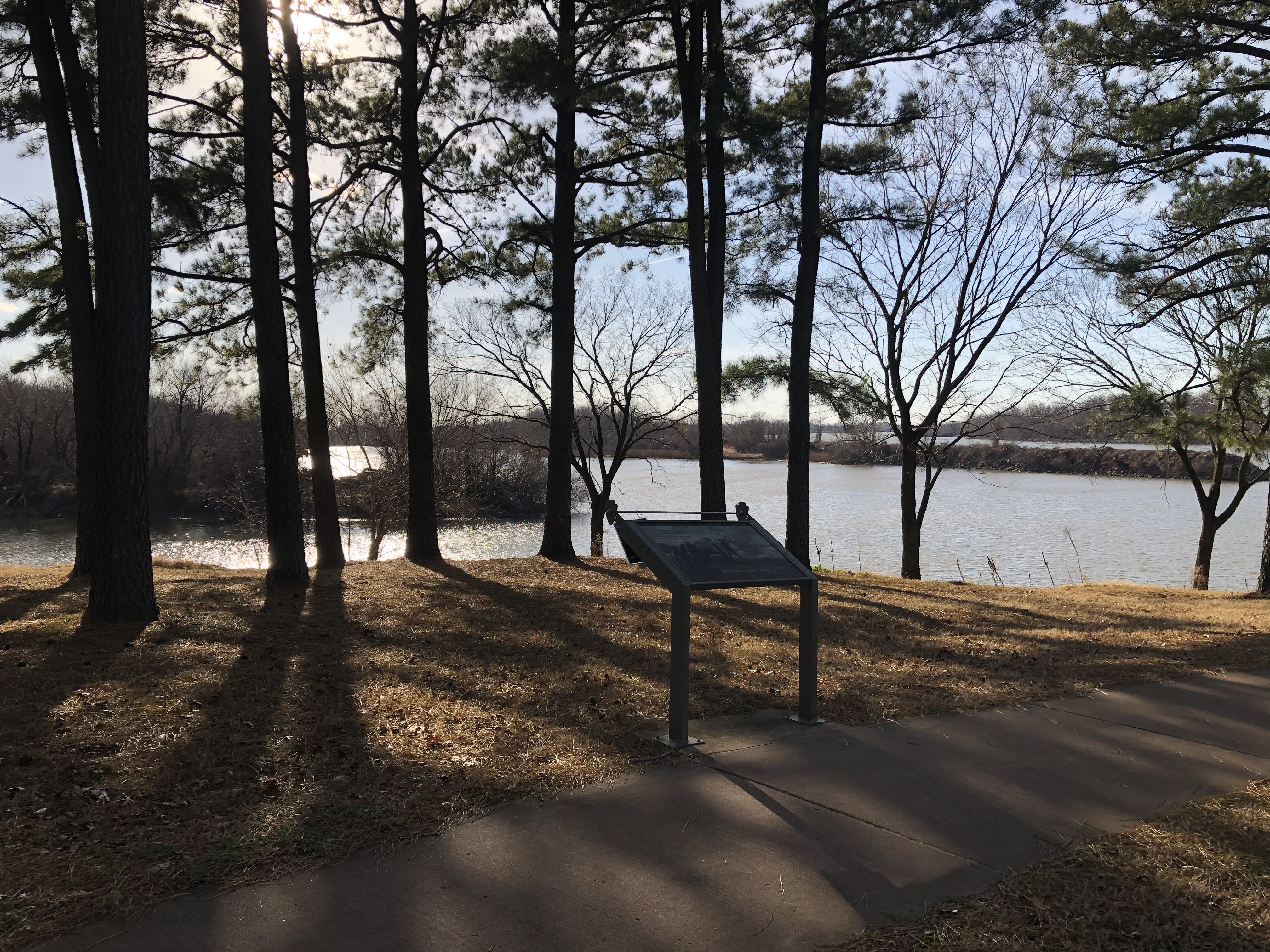
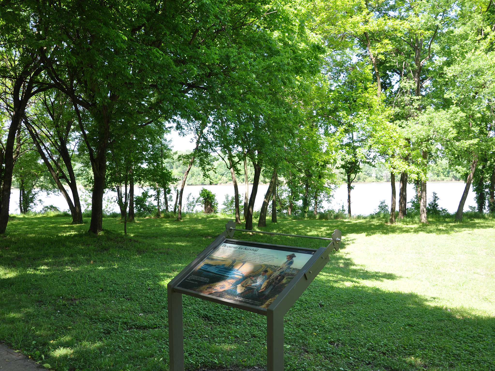
The people living in northwest Arkansas suffered as a result of the war. Thousands believed that leaving the area was the only way to survive.
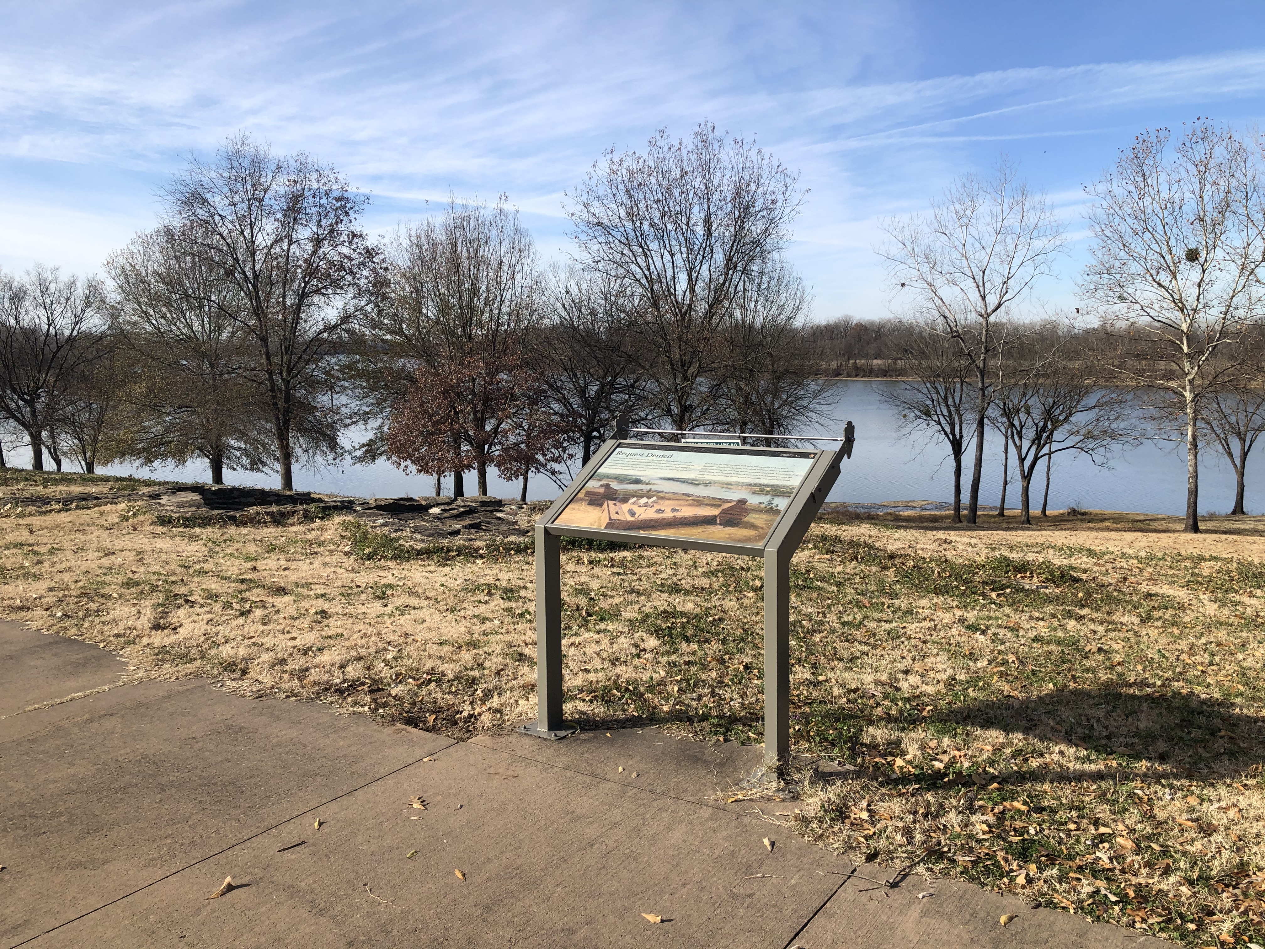
Wayside Panel: Desperate for Survival. 326 words This panel is located beside the cement walkway that runs along the Arkansas River. When facing the west toward the river the riverbank about 80 feet straight ahead. Riverfront Park and the Garrison Avenue Bridge are north, to the right. The foundation of the First Fort is to south, to the left. A line of thin trees grows right along the water’s edge. Across the water, about a quarter mile away, is the state of Oklahoma. The panel is 2 feet deep by 3 ½ feet wide and about 2 ½ feet tall. A full-color illustration shows a young family sitting on a bluff above the river. The father, wearing a ragged shirt and hat, stands with his daughter and looks out over the water. The mother kneels in front with a baby in her arms. Down below, at the river’s edge, a mob waits to board an already crowded steamboat. Text above the image reads: “Standing at this spot during the second half of the Civil War you would have witnessed a very chaotic scene. The riverfront landing at the end of Garrison Avenue would have been filled with hundreds, sometimes thousands, of desperate people anxiously waiting and hoping to find available passage on outgoing steamboats. “Those waiting were orphans, former slaves, pro-Union sympathizers, and rural families seeking protection at Fort Smith from an indiscriminate war. Rogue soldiers (bushwhackers) scavenged the countryside for vengeance, food, livestock, and valuables. Families, like this one, left everything to save themselves and begin a new life—without war.” End of text. A quote on the lower left from the Kansas Newspaper Editor reads: “The people are becoming desperate, exposed as they are to horse thieves on the one hand, and bushwhackers on the other.” Text on the panel’s lower right asks: “Do you have ancestors who were displaced or suffered hardship as the result of a civil war?” End of description.
In 1825, Arkansas Territory was to the East and Choctaw territory to the West.
Area Description. 409 words. This wayside panel stands near the cement path that connects the area of the Second Fort with the area of the First Fort. Active railroad tracks cross the walkway on both sides of you, so be very careful where you walk and listen closely for the sounds of trains and train horns. In this area between the railroad tracks, a rock ledge about 2 ½ feet high borders the path on either side. On your right as you head from the Second Fort to the First Fort area, a cement staircase leads up through a break in the ledge. The staircase is about 5 feet wide, with 11 shallow steps and black iron railings on either side. It leads up a small hill to a grassy plateau that features a couple of historical markers and the location of a former bastion from the Second Fort Smith era. The wayside panel stands about 10 feet to the right of the staircase. A few inches to the right of the wayside panel, a thick black line has been painted across the cement walkway. Southeast of the line, on the side closer to the Second Fort, is the word "Arkansas." On the northwest side, closer to the First Fort, the words "Indian Territory 1834-1907" have been painted on the cement. Bilingual English and Spanish wayside panel: Image in center of panel: Historic map of Indian and Oklahoma Territories 1892. Various colors and shapes indicate different tribal lands. Red jagged vertical line divides the map into two parts. English Text (left side) Indian Territory. The line on the sidewalk behind you represents the 1834 boundary between Indian Territory and Arkansas. Indian Territory was defined as the unsettled land west of the Mississippi River not including states or previously organized territories. Indian Territory has sometimes been portrayed as lawless, and some of the Indians as savages or uncivilized. This portrayal is inaccurate. Tribes had their own customs, languages, newspapers, schools, law enforcement, and governments. They brought these with them when they were forcibly removed to Indian Territory. Tribes living in the territory faced many diverse challenges including competition for resources, outlaws escaping justice, and white settlers wanting more land. The Federal Government also pressured them to assimilate into an Anglo-European way of life. In 1890, the territory was divided into Indian Territory and Oklahoma Territory. In 1907, the two territories merged to form the state of Oklahoma. Texto Español (lado derecho) Territorio Indio. La línea en la acera detrás de usted representa el límite de 1834 entre el Territorio Indio y Arkansas. El Territorio Indio fue definido como la tierra no colonizada al oeste del río Misisipí sin incluir estados o territorios previamente organizados. El Territorio Indio ha sido descrito a veces como un territorio sin ley, y algunos indios como salvajes o incivilizados. Esta representación es inexacta. Las tribus tenían sus propias costumbres, idiomas, periódicos, escuelas, fuerzas policiales, y gobiernos. Trajeron estas organizaciones con ellos cuando fueron expulsados de sus territorios originales hacia el Territorio Indio. Las tribus que vivían en el territorio se enfrentaban a muchos desafíos diversos, como competir por los recursos, bandidos que se escapaban de la justicia, y colonizadores blancos que deseaban más tierra. El gobierno federal además los presionó para que asimilaran el modo de vida anglo-europeo. En 1890, el territorio fue dividido en Territorio Indio y Territorio de Oklahoma. En 1907, los dos territorios se fusionaron para formar el estado de Oklahoma. End of Description.
A history of how Major Bradford's Company of the Rifle Regiment established the first Fort Smith.
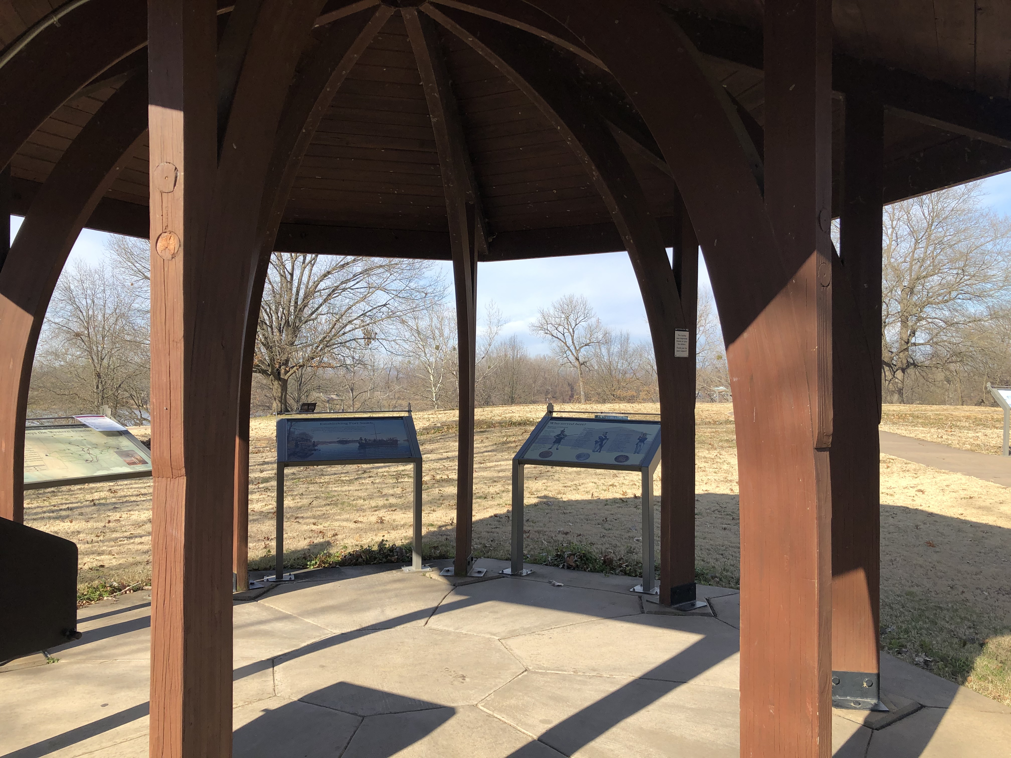
Wayside Panel: Establishing Fort Smith. 231 words. First of two descriptions at this location. A single image fills this panel: an artist rendition shows a wooden keelboat pulling into shore against a landscape of leafless trees and orange brush. Two dozen soldiers crowd the deck, and two more welcome the boat from the rocky shore on the far left. Bright blue skies reflect off the placid water, while a flock of seabirds fly in the distance. Text on the bottom of the panel reads: “As early as the 1790s, the Cherokees began voluntarily moving into the Arkansas River Valley onto Osage land. This fit into President Thomas Jefferson’s belief that the Louisiana Territory would be an ideal homeland for Indians living in the Southeastern United States. Unfortunately, cultural differences between tribes often led to violent clashes. “Hunting parties and villages were attacked, women and children kidnapped, and livestock stolen. Fearing that tribal tension would end voluntary emigration, the U.S. Government established a fort to end the conflict. On Christmas Day 1817, the Regiment of Riflemen arrived at Belle Point officially founding Fort Smith.” End of text. Text above the image quotes Brigadier General Thomas Smith’s orders to Major William Bradford: “Ascend the Arkansas River to the point where the Osage boundary line strikes that river... and therein erect as expeditiously as circumstances will permit a Stockade...” Wayside Panel: Who served here? – Panel Description. 413 words. Second of two descriptions at this location. Detailed color drawings on this panel show three soldiers dressed in different types of uniforms. The drawings are superimposed on a grey and beige background depicting a wooden fort. Below each soldier is a replica of a metal button excavated by archeologists in the 1960s. The buttons feature different insignia and inscriptions. They help historians determine who might have served here. On the left is a rifleman. He wears a green fringed coat and a tall cylinder-shaped hat with a small brim and green feathered crest. He cradles a rifle in the crook of his left arm. The button below him is bronze colored. It features a curved musical horn with the word “Rifle” inscribed within it. Above the horn are 17 small stars in an arc. Text reads: “Regiment of Riflemen, 1817-1822 – After serving with distinction in the War of 1812, the elite Regiment of Riflemen established Fort Smith in 1817. Their mission was to promote peace between the Cherokee and Osage. The regiment merged with the 7th Infantry in 1822.” In the center of the panel is an infantryman. He wears a light blue coat with white straps and grey trousers. His hat is crowned with a small white plume, and he rests his hands casually on the barrel of his rifle. The button below him is silver and decorated with a large cursive letter “I.” The text reads: “7th Infantry, 1822-1824 – One of the five oldest regiments still serving in the United States Army. The 7th Infantry was commanded by Andrew Jackson during the Battle of New Orleans. The 7th Infantry continued the Army’s peace keeping mission at Fort Smith.” On the right is a member of the Artillery Corps. His rich blue coat and hat are trimmed with gold and his pants are grey. In his right hand he grasps a cannon tool that is slightly taller than him. The button below him is bronze colored. It features a cannon in the center with an eagle perched atop it and the word “Corps” inscribed below. The text reads: “Artillery Corps – Archeologists found more buttons from the Artillery Corps than from any other unit at this site. Yet there are no records of the Artillery Corps being stationed at Fort Smith. Could the soldiers have been trading buttons or did members of the Artillery Corps transfer into the 7th Infantry?” End of description.
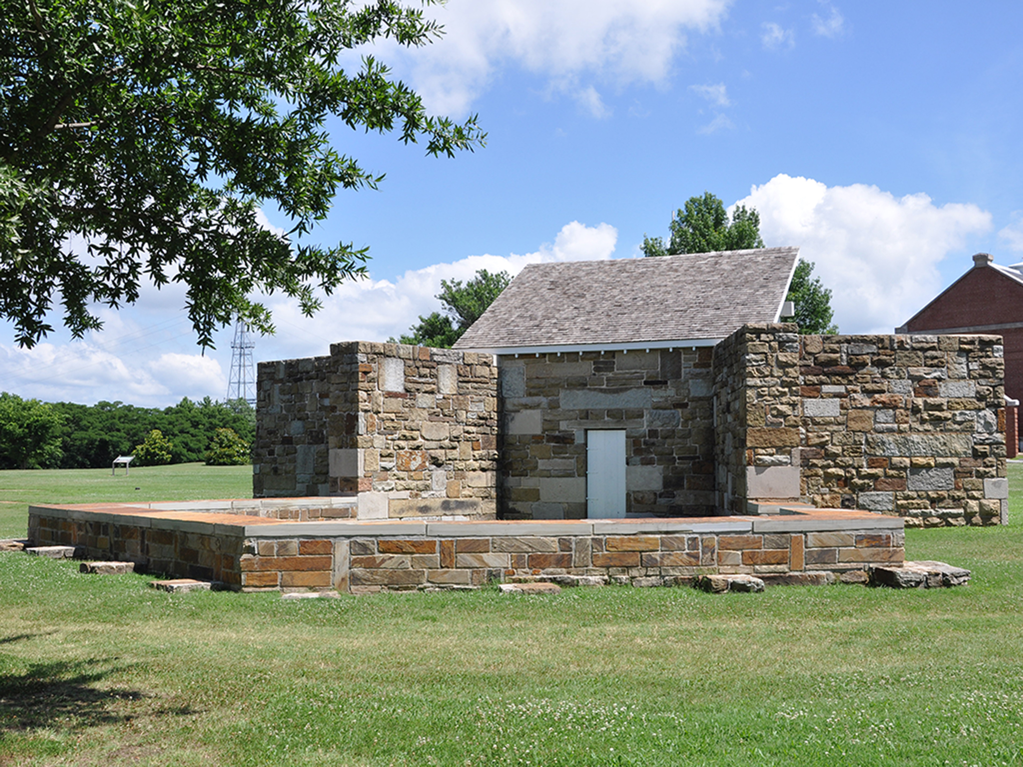
The foundation of the first Fort Smith blockhouse still remains today, although some sections remain hidden underground for their preservation.
Blockhouse of the First Fort Smith. 153 words. At the southernmost corner of the ruins of the First Fort Smith is a stone square about 20 feet long on each side. The grey walls of this stone structure are about two feet thick and are roughly flush with the grassy landscape around it. Inside the square, the walls descend about two feet to the sunken ground within. This stone structure was the foundation of the Fort Smith blockhouse. The blockhouse was a two-story wooden structure meant to help protect against attack. A narrow set of uneven stairs about two feet wide is built into the wall near the northern corner of the blockhouse. Four stone steps lead down into the square. A broken line of grey stones about one foot wide extends northeast from the blockhouse. This is all that remains from the foundation of the outer wall of the fort. End of description.
The first Fort Smith was named after the commander of the US Army Rifle Regiment, General Thomas Smith. It was located at Belle Point at the confluence of the Arkansas and Poteau Rivers and was active for just over six years.
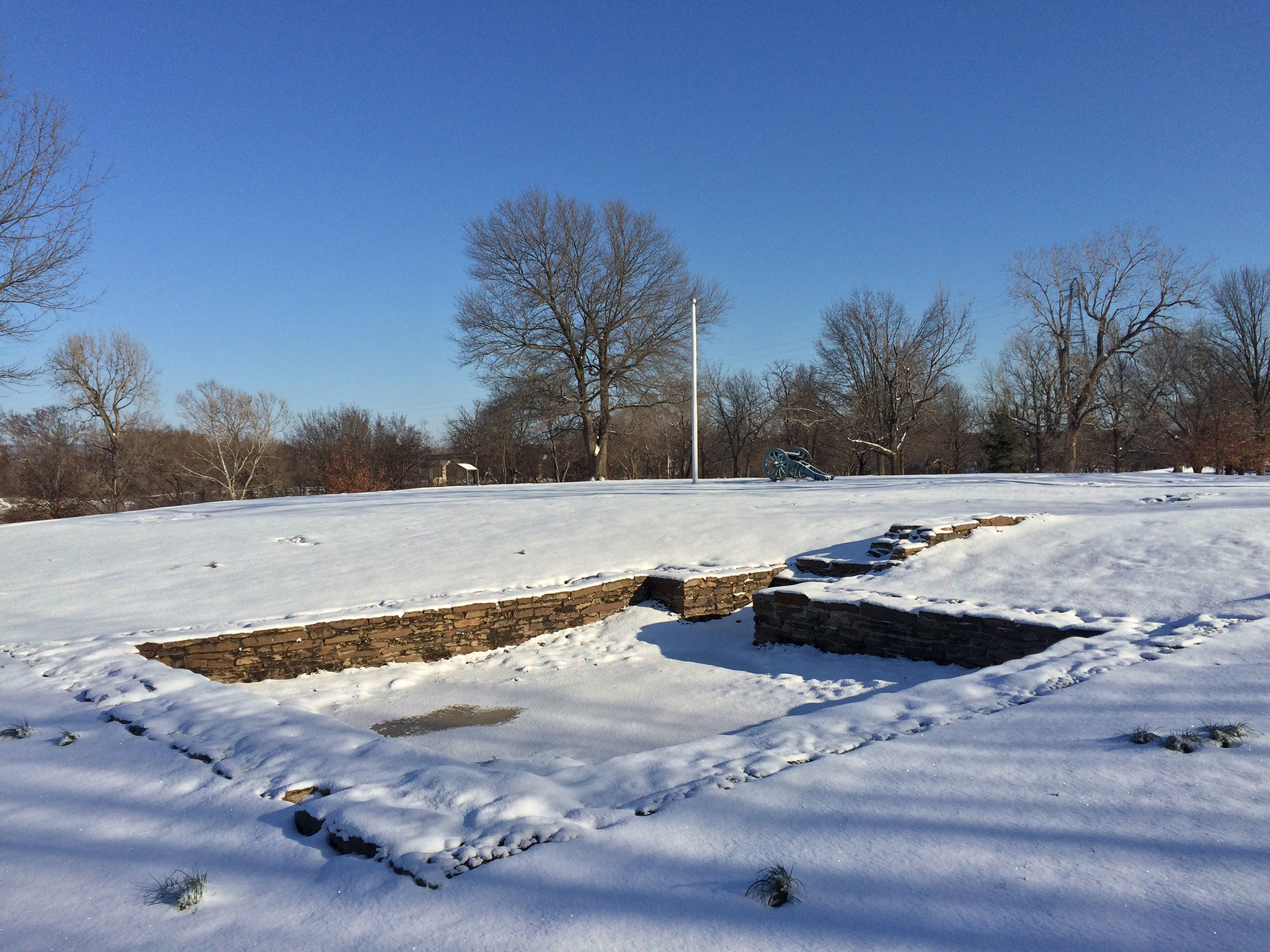
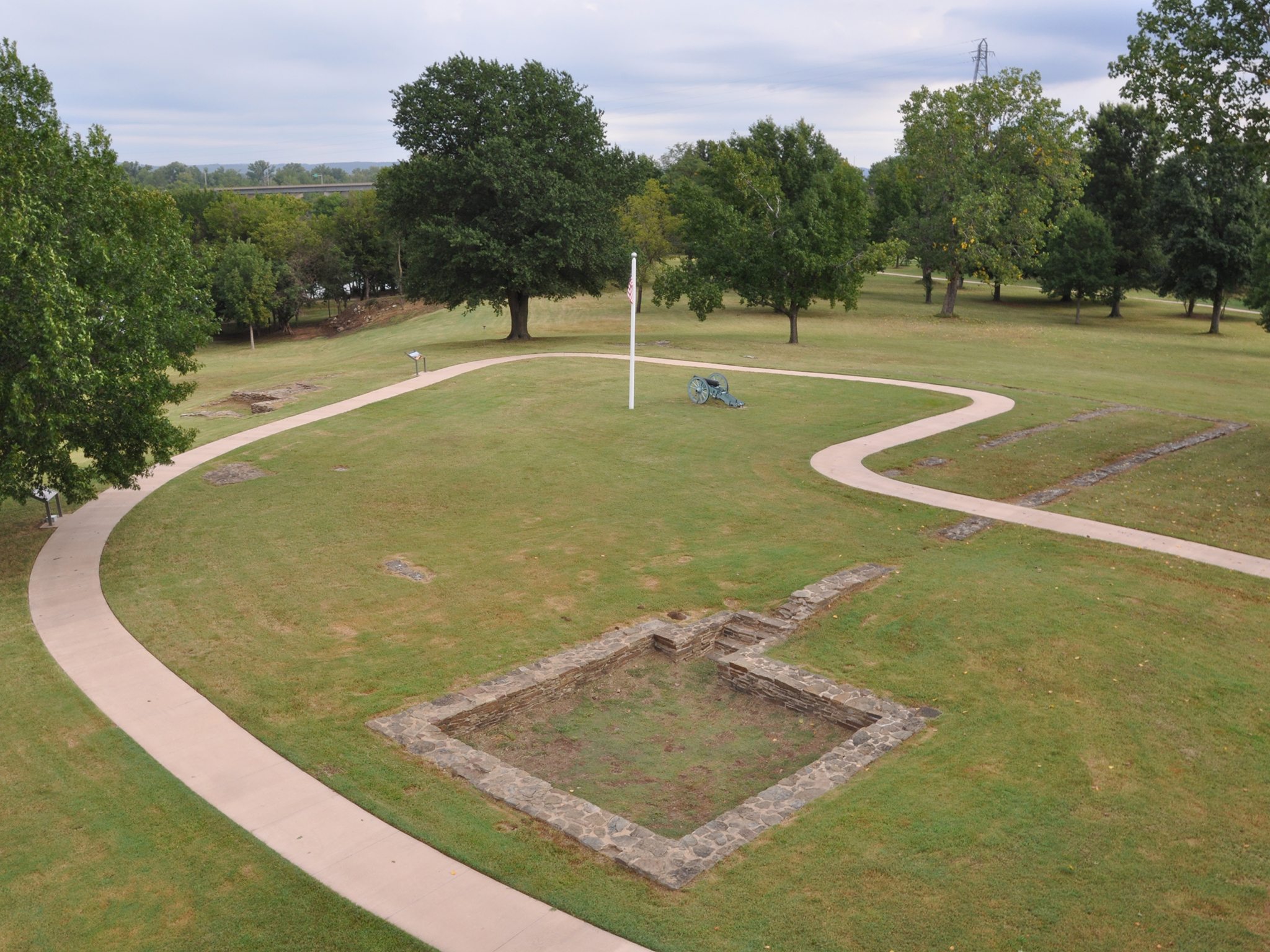
First Fort Smith. Area description 2 minutes. This grassy plateau was the site of the First Fort Smith, built in 1817. Today, a few vestiges of its stone foundations are all that remain of the fort. The fort's foundations form a broken grey square on the green landscape. Each side of the square is about 100 feet long. At the southernmost corner of the fort's footprint is the blockhouse, a smaller stone square measuring about 20 feet on each side. This is the best-preserved portion of the former fort. From the blockhouse, two parallel stone lines extend northeast, creating the fort's southeastern edge. Each line of stone is about one foot wide, and the two are about 10 feet apart. In some places, the rough stone sticks up an inch or two above the grass. In other spots, the stone foundations have disappeared altogether. The modern cement walkway cuts across the foundations as it weaves in and out of the ruins. A single line of stone forms the northeast side of the fort. On the northwest and southwest sides of the fort, the foundations of the wall are largely absent. The remnants of a structure are visible, however, near what would have been the western corner of the fort. This irregularly shaped structure is set into the edge of the hill. It's a little smaller than the blockhouse and contains several low walls, platforms, and steps. In a few spots, stone markers have been set into the grass to mark the original locations of different parts of the fort. One is marked "Dining Room." Others read "Carpenter's Shop" and "Wheelwright" shop. Flag of the First Fort Smith. 1.25 minutes. A white flagpole about 25 feet tall stands in the middle of the footprint of the First Fort Smith. The fort no longer exists; only some of the fort wall's stone foundations are evident today. A modern cement walkway circles the site, weaving in and out of the ruined foundations. In the center of the fort foundation is the flagpole, white with a grey wooden knob on top. It is a replica of the pole that would have stood in the fort. Hanging from the top of the staff is an American flag with 15 stars and 15 stripes. A few feet to the north of the flagpole is a black, six-pound cannon mounted on a metallic-green, two-wheeled fame. The barrel is about 5 feet long. It points west, toward the Arkansas River and the former Indian Territory, now Oklahoma, in the distance. This is a replica of the type of cannon that would have been used at the First Fort Smith. End of description.
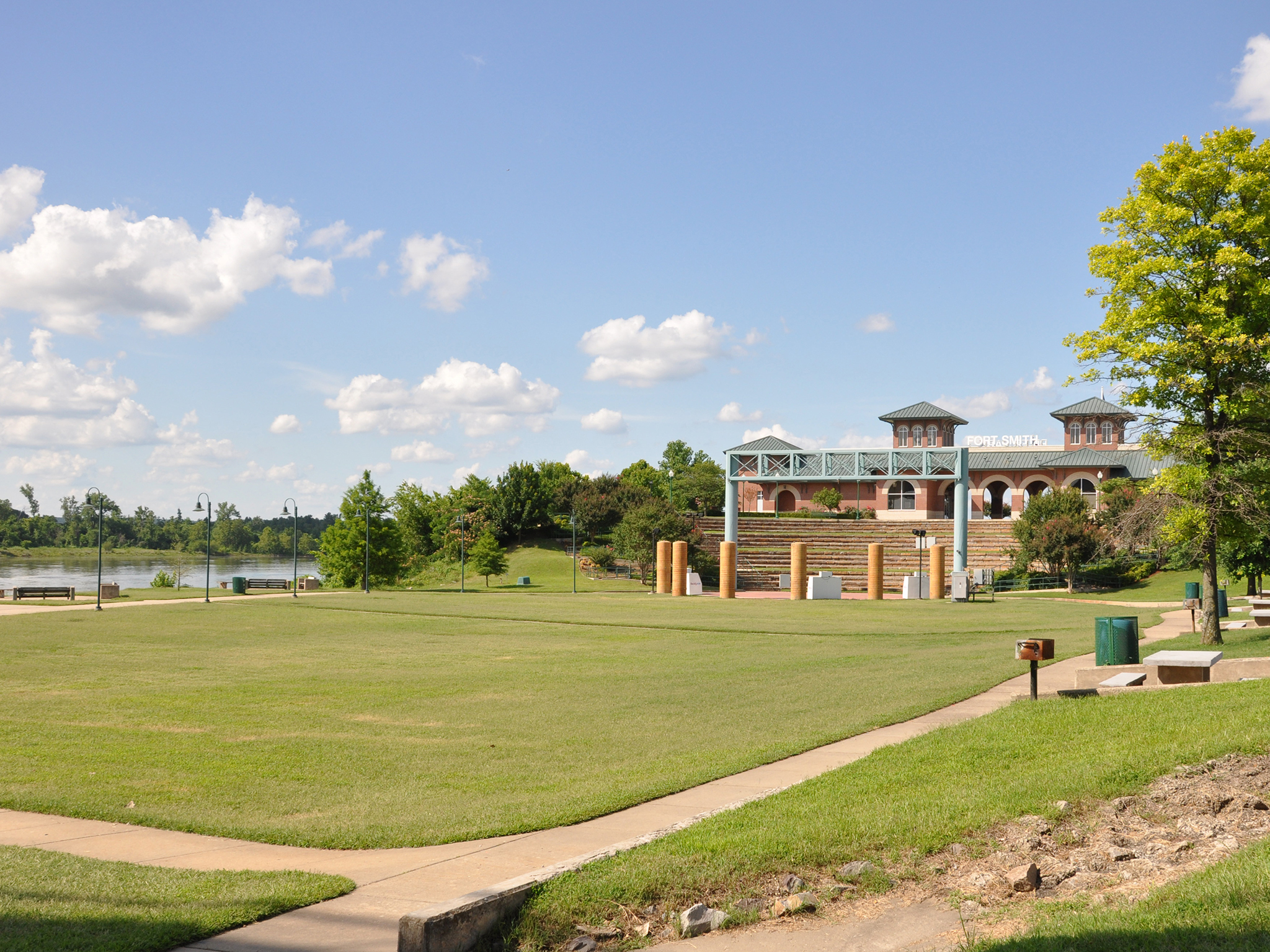
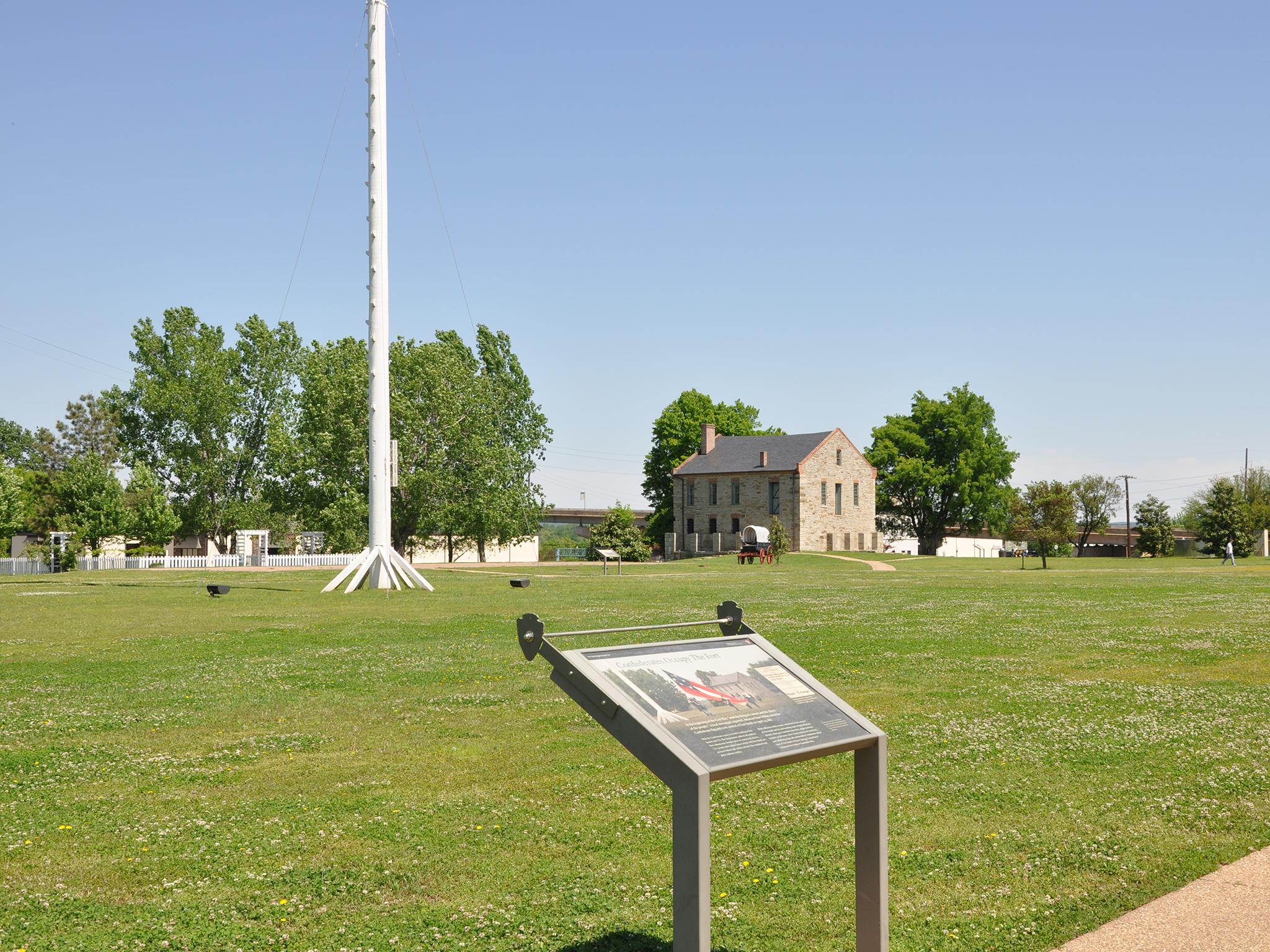
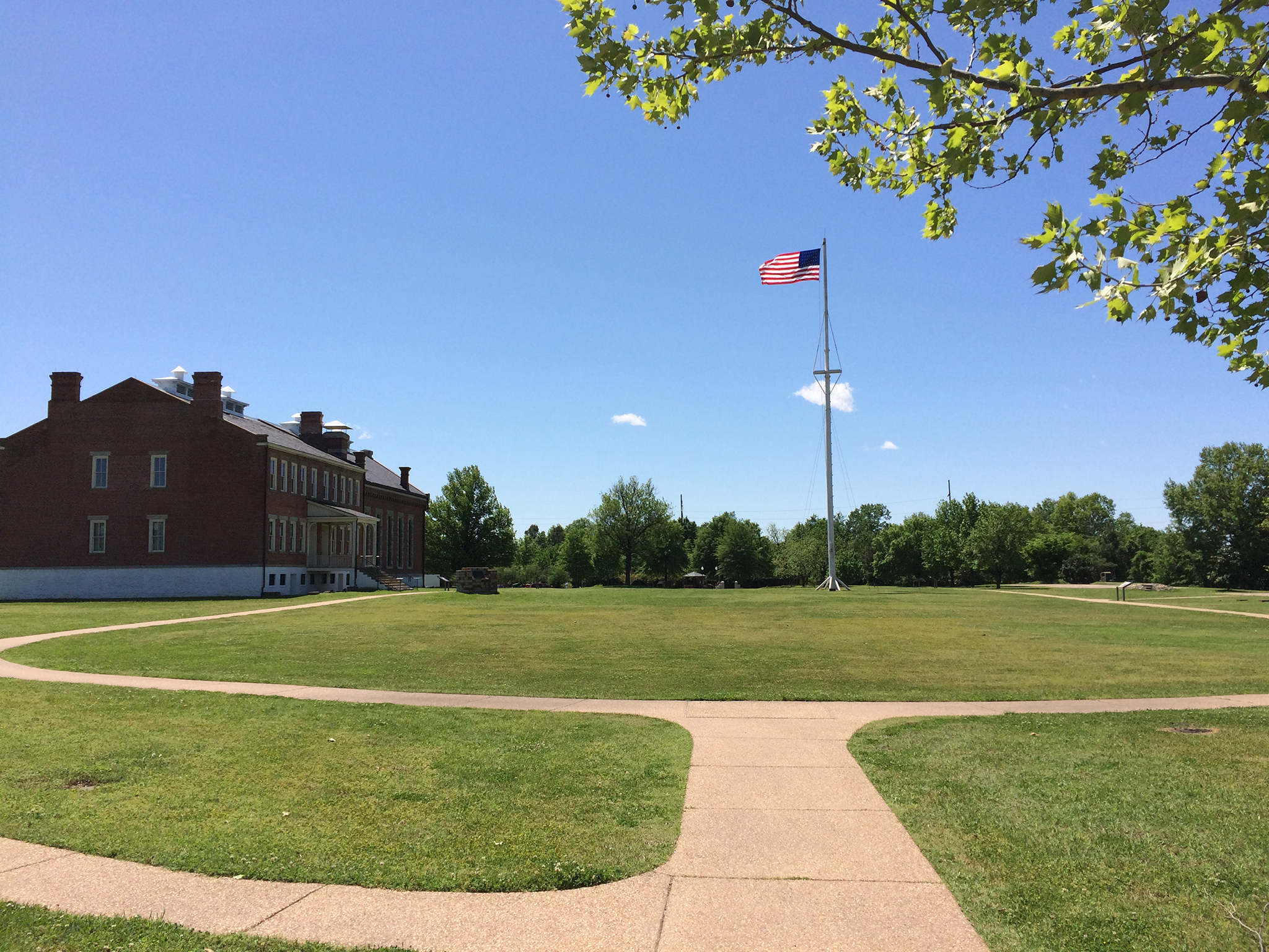
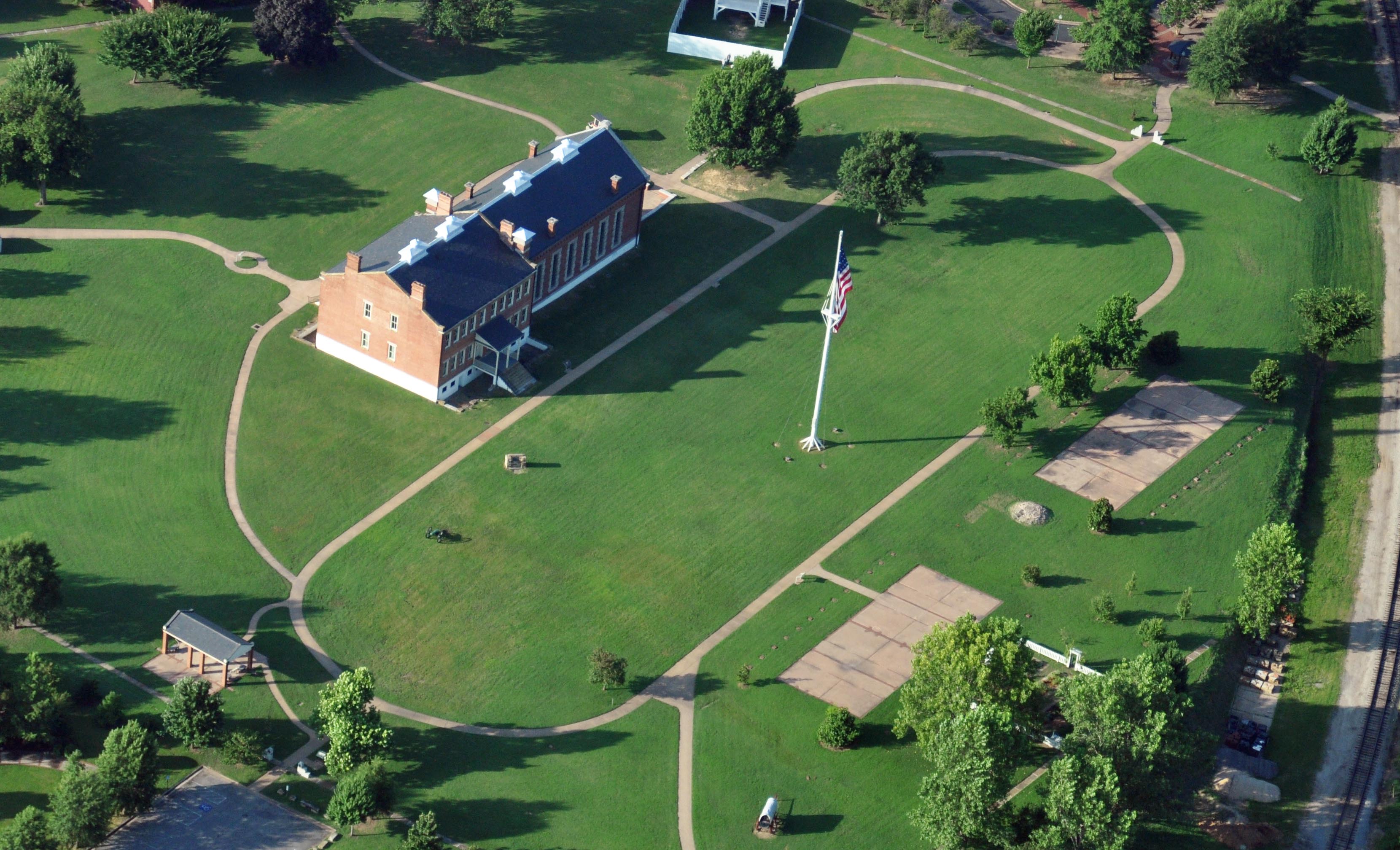
From 1846-1871, the parade ground was the center of life at the fort.
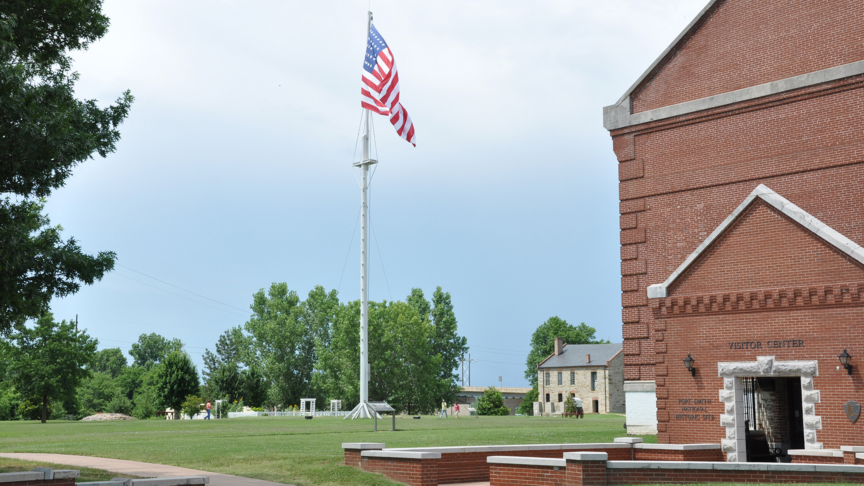
Wayside Panel: The Flagstaff - Area Description. 510 words. This wayside panel sits just inside the oval cement walkway that rings the Fort Smith Parade Ground. The panel is situated so the Officer's Quarter (south) are directly behind you. To your left is the flagstaff in the middle of the Parade Ground. The tall white flagstaff is about a hundred feet in front of you. Several support wires angle up from the ground and attach to the pole about halfway up its 100-foot height. A short horizontal beam intersects the pole just above that point and additional wires connect the beam to the pole above and below it. The flagpole is a modern replica of the flagstaff that stood here until the army left in 1871. At the pinnacle of the flagstaff is an American flag with 37 stars. It's a copy of the last flag flown at Fort Smith from 1867 to 1871. Wayside Panel: The Flagstaff - Panel Description. A colorful image on the bottom left of this panel shows how the second Fort Smith would have looked in the 1850s. It's a reproduction of a 1911 painting by Treseder. The perspective is from the north, just a little bit behind where you are now. The view is from a slightly elevated perspective so that the interior of the compound is visible over the stone wall that encircles it. The flagpole stands in the middle of the Parade Ground, under a bluish-pink sky. Several buildings occupy the site, though the barracks and commissary are the only buildings shown that still remain today. The gentle rolling landscape outside the fort walls is dotted with smaller houses and trees. The Poteau River flows past in the background. Text above the image reads: The U.S. Army built the original flagstaff at the second Fort Smith in 1846. As with many western military posts, the flagstaff stood tall so that its flag could be seen for miles. To attain a height of nearly 100 feet, the army joined two poles in the same way that ship masts were built. Historically, shroud lines attached to cross trees supported the area where the poles were joined, while guidelines and an underground wooden structure stabilized the base. "When the army closed Fort Smith in 1871, they removed the flagstaff. The ‘Old Fort Militia,' a local citizen's support group, in cooperation with the National Park Service rebuilt the flagstaff in 1984-85. Its 37-star flag is a replica of the last flag flown here by the army, from 1867 to 1871." End of text. To the right of the main image is a black-and-white drawing of the flagpole, showing the guy wires and a cross-section of the underground supports. A quote from Mary Rutherford Cravens reads: “In the center of this circle [the parade ground] stood a tall flag-staff, from which dizzy height, ‘Old Glory,' flung its protecting folds to the breeze. Morning and evening to the salute of a cannon and the strains of martial music, the flag was raised and lowered." End of description.
Built in 1838, the historic Commissary building's uses and appearance have changed many times throughout its nearly two centuries standing.
The Commissary. 125 words. The commissary building sits at the northern edge of the Fort Smith Parade Ground. Its southeastern and southwestern facades face the rest of the second fort site. A cement path connects the building to the oval walkway that rings the grassy Parade Ground. The two-story structure is built of gray, rough-hewn stone. Four windows grace the southeastern facade. The southwestern face features 7 windows and small doorway on the right. The roofline and window lintels are highlighted with red brick and the pitched roof is clad in black shingles. Thick walls made of larger, smoother stones are visible around the base of the structure, showing evidence of its original use as a fortified bastion. The footprint of the building is approximately 30 by 40 feet. End of description.
The Guardhouse. 294 words. First of three descriptions at this location. This is the site of the former guardhouse of the second Fort Smith. The original building no longer exists; now a modern, open structure, about 30 feet wide by 10 feet deep, fills most of the site. Eight square brick columns support a pitched wood shingled roof-one column in each corner and two more supporting each of the longer sides. A smooth cement floor extends about six feet beyond each of the long sides of the structure. The cement floor represents the full footprint of the historical guardhouse. It's surrounded on all sides by grass. The existing structure is oriented northwest to southeast. Parallel to the long northeast side of the building, a few feet beyond the cement floor, is a one-foot wide strip of stones set flush into the grass. This represents the original outer wall of the fort. To the southwest of the guardhouse is the parade ground. A short, curved walkway connects the guardhouse to the oval cement path that circles the parade ground. About 150 feet to the northwest of the guardhouse is the commissary. Inside the guardhouse structure, there are two wayside panels, one in the middle of each of the shorter sides. The panel on the northwest side describes the history of the guardhouse from 1849 to 1871. The panel on the southeast side covers the period from 1872 to 1888, when the guardhouse served as a women's jail. Low, backless benches sit on either side of each panel, blocking access to the structure from the northwest and southeast. Otherwise, the interior space is completely open. Brick lines, set flush into the cement floor, mark the original locations of the interior and exterior walls of the guardhouse. Wayside Panel: The Guardhouse, 1849-1871 - Main text. 191 words. Second of three descriptions at this location. From this wayside panel, you face northwest toward the Commissary Building, about 150 feet away. The panel features three images, which will be described in the next message. Text at the top center of the panel reads: "The guardhouse, constructed in 1849, was a focal point of daily activity at the second Fort Smith. Not only did the men assigned to guard detail operate out of this building, but the officer of the day, who was responsible for the daily business of the post, worked out of an office located here. The guardhouse was also the place of confinement for soldiers under arrest for such offenses as drunkenness, desertion, or fighting. "The Guard Mount, or changing of the guard ceremony, occurred here once a day usually about 9:00 a.m. At that time, the old guard detail would be inspected and mustered out, and the new guard detail would be inspected and mustered in. Members of the guard detail served as sentries throughout the fort grounds, at each gate, and watched prisoners in the guardhouse." Wayside Panel: The Guardhouse, 1849-1871 - Images and Additional Text. 270 words. Third of three descriptions at this location. On the left side of this panel is a color image of a guard standing at attention. He wears a blue and grey uniform with brass buttons, a dark hat with an insignia in the shape of a musical horn, and white gloves. He holds the shaft of his rifle in his right hand with the butt resting on the ground. Text reads: "Soldiers on guard detail remained in full uniform throughout their 24-hour tour of duty. This allowed them to be prepared to answer any emergency that arose, even during periods of rest. "In the bottom center of the panel is a black-and-white photograph featuring one of the few known images of the guardhouse. The photograph looks east from within the fort. The fort wall runs diagonally across the image from bottom left to upper right, with the guardhouse on the right edge of the photo. As the text points out, a visitor to the fort would have entered through the main gate in the center of the photo and then checked in at the guardhouse. On the upper right of the panel is a floor plan of the guardhouse taken from the 1849 construction drawings. It shows the locations of the porch, jail cells, room for the Officer of the Guard, room for the Guard Detail, and general prison room. Text below reads: "In 2000, the National Park Service placed this concrete pad on the approximate location of the guardhouse. It matches the floor plan above." End of description.
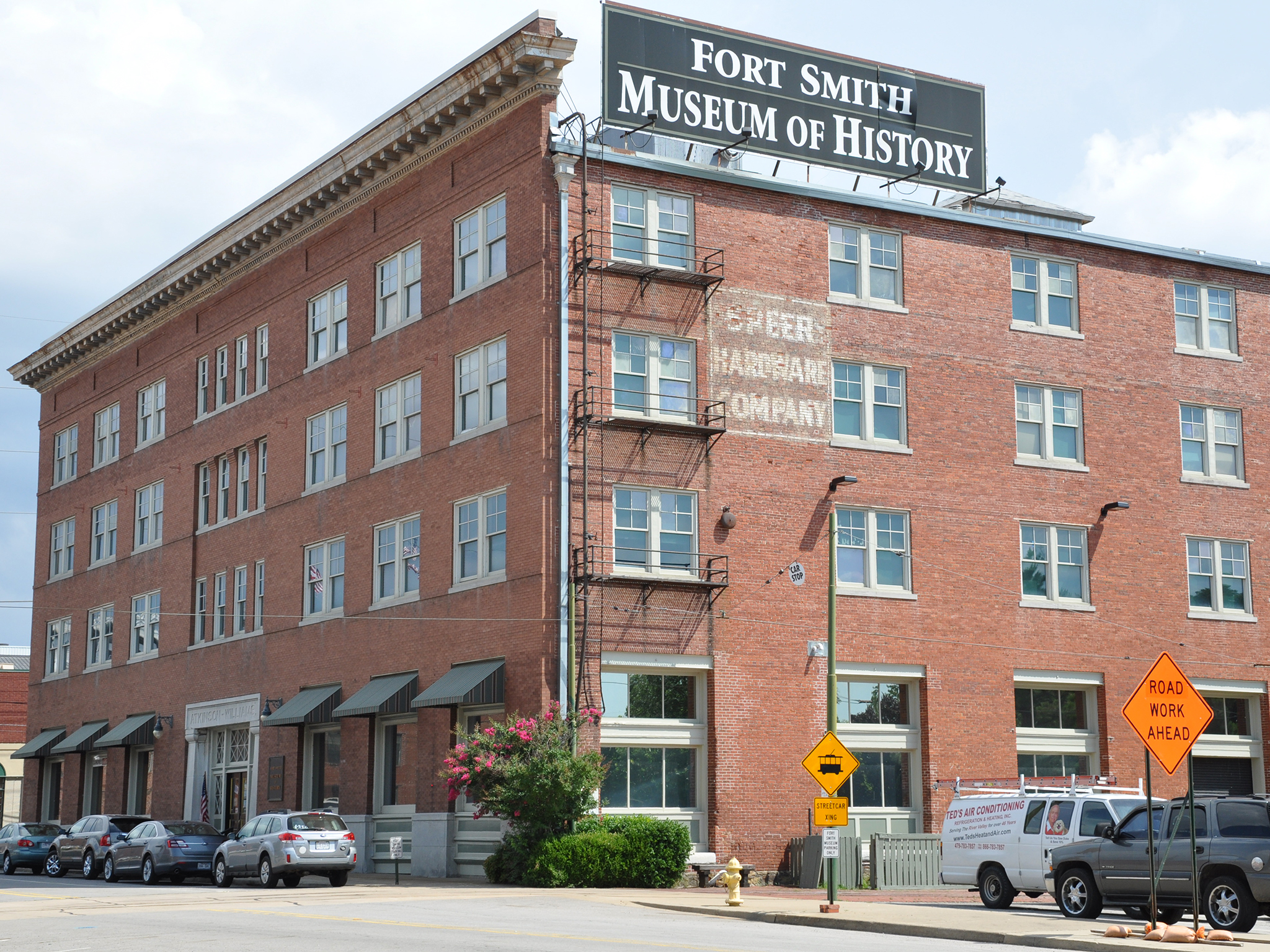
Fort Smith Museum of History. 207 words. The Fort Smith History Museum is located at the western corner of Rogers Avenue and 4th Street, just a few hundred feet south of Fort Smith National Historic Site. The museum is housed in a four-story red-brick building with limestone trim. The block-like historic structure was built in 1907 as a warehouse for the Atkinson Williams Hardware Company. The main entrance faces Rogers Avenue. Two steps lead up to the windowed double doors. The words “Atkinson-Williams” are inscribed in capital letters into the limestone lintel above the doors; a black plaque with bonze-colored letters to the right of the doors reads: “Fort Smith Museum of History.” A second entrance on 4th Street is accessible via a ramp that runs along the 4th Street façade from Rogers Avenue. Inside, the museum has an elevator and ramps for easy access to all exhibits. Large storefront-type windows line the first floor of the building above a three-foot limestone base. There are six such windows on the Rogers Avenue side and four facing 4th Street. Three rows of smaller windows line the upper floors of the building. A small parking area is located on the northwest side of the building, accessed from Rogers Avenue. End of description.
National Cemetery for veterans from the War of 1812 to present.
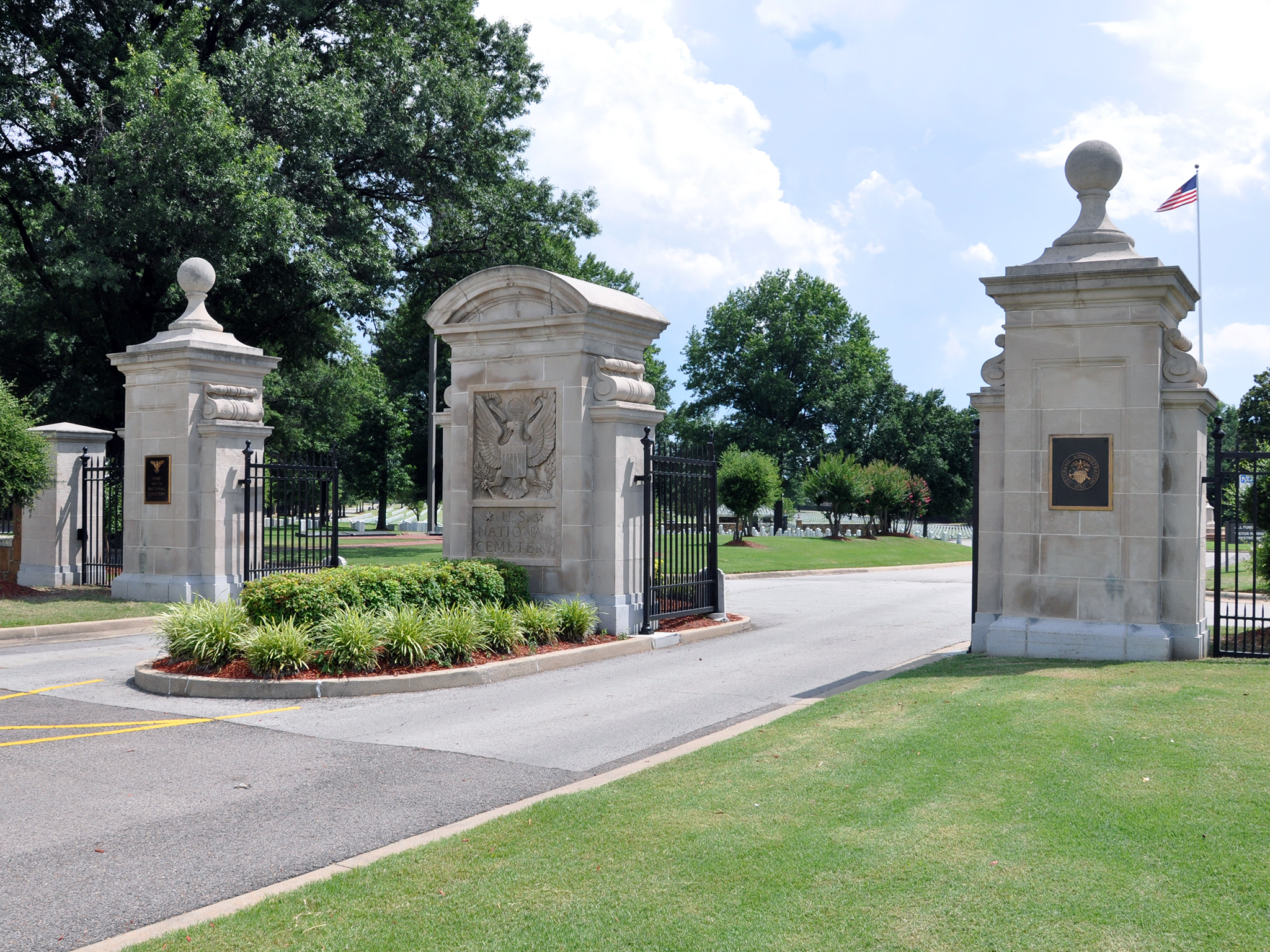
Fort Smith National Cemetery. 242 words. This is the main entrance to Fort Smith National Cemetery. A two-way road leads off of Garland Avenue into the facility. Cars pass through a double wrought-iron gate supported by stone columns. Smaller pedestrian gates are located on either side of the roadway. To the right of the entrance, a white sign about 3 feet high and two feet wide carries the words “Fort Smith National Cemetery” in gold lettering. The sign is mounted on a low stone wall about six feet long. Inside the gate, to the right of the main road, is the administration building. This is a two-story brick building with a hipped roof and central porch. Just past the building, along the main entryway, is a flagpole set within a circular plaza. On the other side of the flagpole, the road runs to the west before splitting in two, forming a small triangular section. All of the graves in the Fort Smith National Cemetery are laid in rows running north and south, except for four rows just south of this triangle that run northeast to southwest. The cemetery comprises more than 22 acres of land and contains more than 13,000 graves. Judge Isaac C. Parker is buried in Grave #4000, Section 9, Row 3. He lies beneath a simple, nondescript stone marker inscribed with the number 4000 and the name Isaac C. Parker within the outline of a shield. End of description.
Fort Smith National Historic Site includes remains of two frontier forts and the Federal Court of the Western District of Arkansas. Black enlisted Army soldiers helped establish the first Fort Smith in 1817.
Fort Smith witnessed life on the edge of Indian Territory, and the park tells its stories through the experiences of soldiers, outlaws, and lawmen. For those on the Trail of Tears, it was the last point of federal land before entering Indian Territory. The site has in-depth exhibits about Indian removal.
Fort Smith was based on coastal fort design with a stone wall 12 feet high and 2 feet thick.
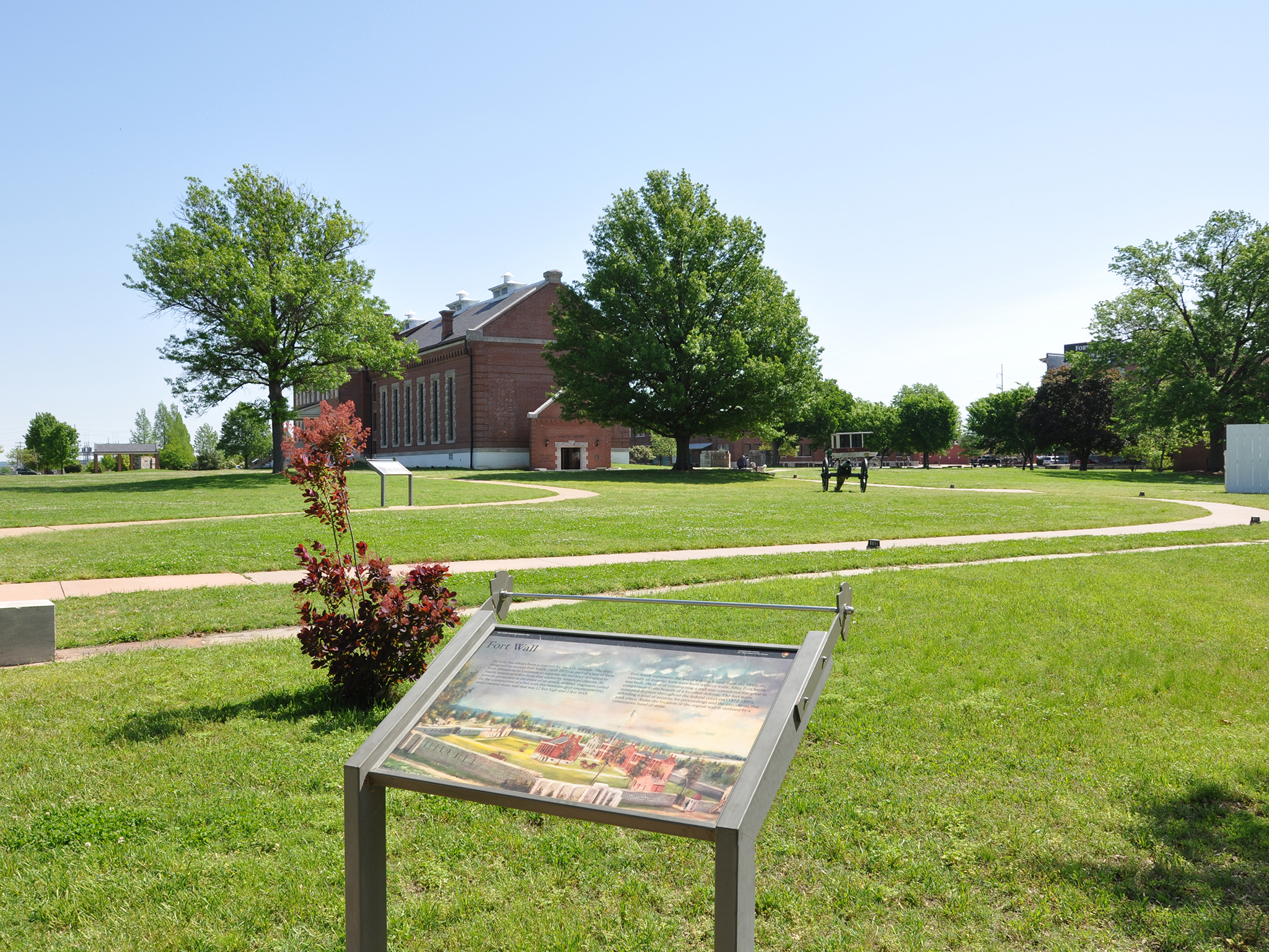
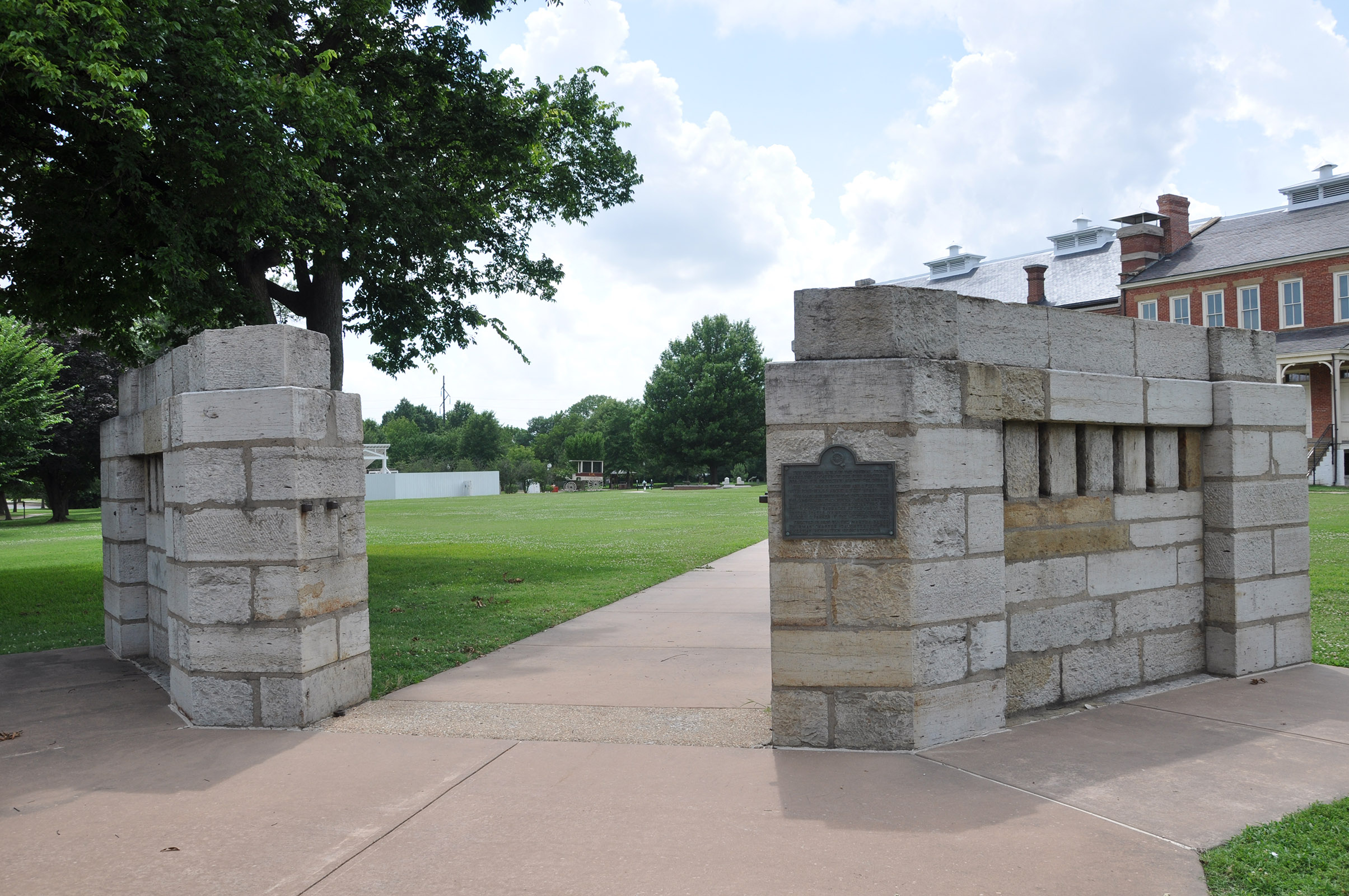
Wayside Panel: Fort Wall - Area Description. 209 words. First of two descriptions at this location. You are just outside the perimeter of the second Fort Smith, which was built in 1838. About 15 feet to the left of this wayside panel, a line of stones in the grass intersects with the cement walkway. The strip of grey stone, about one foot across, marks the location of the former fort wall. Where the wall line intersects the walkway, there are two light grey stone pillars that create a kind of entrance way into the site. The pillars step up from the sides to a height of about 4 feet where they frame the pathway The path continues into the site another 30 feet or so, where it meets an oval-shaped walkway that encircles the open Parade Ground. A flagpole in the middle of the Parade Ground rises about 100 feet above the grass, and an American flag with 37 stars flies at its top. Just to the right of the Parade Ground is the former barracks/courthouse/jail building-now the Visitor Center. Further to your right as you face the flagpole is the gallows-about 60 feet away. It's a white structure surrounded by a tall white wood plank fence. Wayside Panel: Fort Wall - Panel Description. 322 word. Second of two descriptions at this location. A single, colorful image takes up this entire panel. It's a reproduction of a 1911 painting by Treseder that shows how the second Fort Smith might have looked in the 1850s. The painting depicts the fort from the north-directly opposite the side you're on now. The view is from a slightly elevated perspective so that the interior of the compound is visible over the stone wall that encircles it. The jail/barracks/courthouse building stands in the middle of the scene, with the flagpole to its right. Several other buildings occupy the site, including a row of two-story structures along the right-hand wall of the compound. The gentle rolling landscape outside the fort walls is dotted with smaller houses and trees. The Arkansas River flows past in the background. Text at the top of the panel reads "Security has always been a concern for the U.S. military. The army designed the second Fort Smith (1838-1871) as part of a line of forts from Minnesota to Louisiana to separate the territory occupied by Native American tribes from that settled by American citizens. To provide protection in the event of an attack, military engineers called for the construction of a fort with five bastions (gun emplacements), and a massive stone wall that was 12 feet high and 2 feet thick. Fort Smith represents the last of a dying breed; from the 1840s on, virtually all frontier forts were built without walls. After Fort Smith was built, the cost of constructing a wall was considered too great in comparison to the benefit of a fortified defense. The fort walls remained in place throughout the federal court era (1872-1897), affording a level of security for proceedings and the executions that took place. Today the location of the original wall is outlined by a continuous band of stone." End of description.
Constructed in 1903, it is the last of several railroad stations that were built in Fort Smith. The station served as a passenger and freight depot for the St. Louis-San Francisco Railway Company.
Frisco Building. 1 ½ minutes. The Frisco Building originally served as a passenger depot for the Frisco Railroad. The building is currently closed to the public. The structure sits just to the north of the commissary, down a small hill. The Frisco building is oriented toward the northwest, where a set of railroad tracks still run past from northeast to southwest. These are active tracks, so watch your step and listen carefully for sound of train horns. The rectangular, two-story building measures about 80 feet across the front and 30 feet along the shorter sides. It's constructed mainly of smooth, sandy-grey stone, and has a flat roof. The windows are trimmed in blue and orange, and thin blue columns create a colonnade along the building's northwest facade. A hard awning shingled with rust-orange tiles protrudes from just above the first floor. On the southwest side, black lettering above the three second-story windows spell out the words "Frisco" and "Fort Smith." A large parking area stretches to the southeast from the back of the building. Cars enter the parking area from Garrison Avenue, which runs past the building on the northeast side. End of description.
Execution by hanging. In Fort Smith, 81 men were hanged for murder and 5 for rape.
The Gallows. 259 words. First of three descriptions at this location. This is a reconstruction of the original Fort Smith gallows. The gallows area is about 50 feet by 50 feet and enclosed by a white picket fence 12 feet high. Within the area, along the south edge of the enclosure, is the gallows structure itself. The gallows structure features a wooden platform about 30 feet long by 20 feet deep. The platform sits about 6 feet off the ground, supported by 4 one-foot square columns. Stairs lead up to the platform on the right side, but these are closed to the public. A horizontal beam sits about 10 feet above the platform, running the full length of gallows. This is the cross beam, from which the noose would have been hung. It rests on two square support columns and is braced from above by two diagonal beams. The whole structure is painted white. It is topped by a shingled wooden roof that slopes down toward the back, where it meets a 13-foot stone support wall. A single door in the fence opposite the gallows structure provides access to the area. To your right as you enter, is a white metal box on a stand. The box measures about a foot on each side and stands three feet off the ground. A button on the side of the box triggers an audio message about the gallows. The cement walkway that leads into the enclosure turns left immediately and continues about 8 feet. Two wayside panels along this path explore the gallows’ history. Wayside Panel: Executions at Fort Smith. 189 words. Second of three descriptions at this location. This angled sign is 3.5 feet across and stands 2.5 feet off the ground. The bottom three-quarters of the panel are taken up by a grey box with four columns of white text. It’s a list of the names and execution dates for the 87 men hanged at Fort Smith. Above the list, text reads: “During the twenty-four years that federal executions took place in Fort Smith, eighty-seven men died on the gallows. While Judge Isaac C. Parker sat on the bench, 160 people, including four women, were sentenced to hang. Just over half received a reprieve from execution through pardons, commutations, reversals or acquittals on appeal, or death in jail. The men listed below were hanged in Fort Smith.” End of text. To the right of the text is a small black-and-white photograph of a man with a white beard and shadowy eyes. He wears a dark suit. The text reads: “George Maledon, known as the Prince of Hangmen, served as executioner at over half of the Fort Smith hangings.” Wayside Panel: The Gallows. 320 words. Third of three descriptions at this location. A simple black-and-white drawing fills the bottom half of this 2-foot by 3.5-foot panel. The drawing shows the Fort Smith gallows looking much like the replica structure that stands here today. Seven men and one woman stand on the platform. One of the men has his hands bound in front of him. A rope hangs from the cross beam. A mob of spectators wearing wide-brimmed hats fills the area in front of the platform. Text above the drawing reads: “With the largest criminal jurisdiction of any federal court at that time, the Western District of Arkansas handled an extraordinary number of murder and rape cases. When a jury found defendants guilty in these capital cases, federal law mandated the death penalty. In Fort Smith, that meant an execution by hanging on a ‘crude and unsightly’ gallows. “A visitor to the city in 1893 recommended constructing a new gallows to evoke the ‘sacredness and majesty of the law.’ This was never achieved and a year after the last execution, the city of Fort Smith destroyed the gallows structure. “This sketch is the only known image of the gallows. It depicts the execution of Crawford Goldsby, alias Cherokee Bill, on March 17, 1896. Although cameras were prohibited at hangings, a young man captured the scene with a Kodak, which he quickly hid in his coat. The sketch was later taken from that photograph.” End of text. In the upper right-hand corner is a black-and-white photo of a man with white hair and a white beard. He wears a dark suit and a serious expression. The text reads: “Judge Isaac C. Parker sentenced 160 people (four of whom were women) to hang. Of these, 79 men were hanged.” Beside the image is the following quote from Jude Parker: “I do not desire to hang you men. It is the law.” End of description.
The quartermaster's storehouse and the initial point marker for the boundary survey.
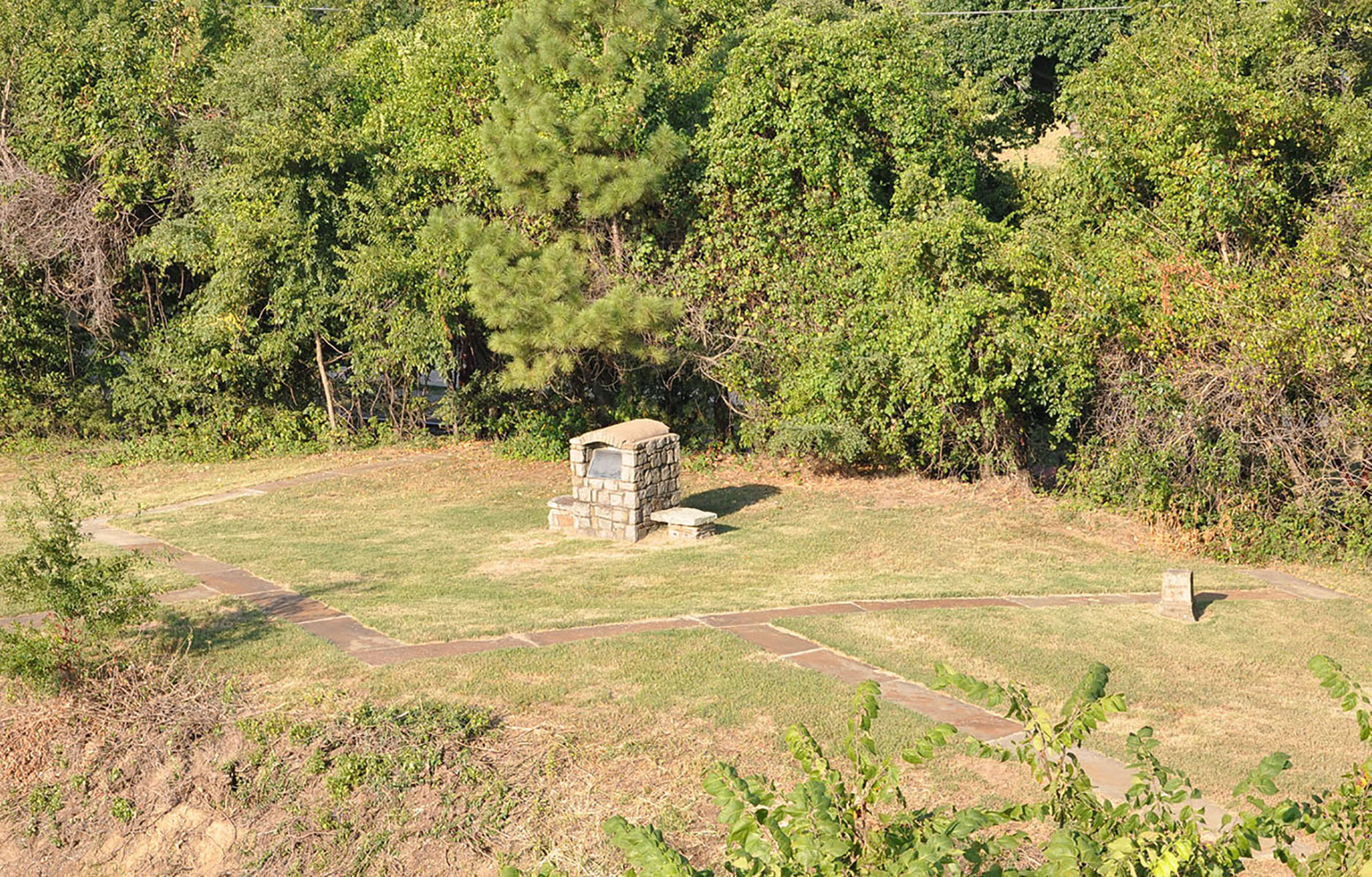
Bastion #2. 218 words First of three descriptions at this location. This is the former location of Bastion #2, one of five pentagon-shaped enclosures that fortified the wall surrounding the second Fort Smith. It later the location of the Quartermaster's storehouse. It's on a small hill. This area is reached via a wide staircase from the cement walkway that connects the Second Fort area with the First Fort area. There are 11 steps up from the walkway. A slightly uneven dirt path leads straight ahead about 40 feet from the top of the staircase to the bastion area. The bastion no longer stands; today its outline is marked by a one-foot wide strip of stone set flush into the grass. The outline of the bastion is roughly 20 feet by 20 feet. Active railroad tracks run roughly north-south on either side of the hill. On the east side, closest to the Second Fort Smith, the hill slopes steeply down about six feet to the railroad track. So be careful if you stray off the dirt path. On the west side, closer to the First Fort Smith, a line of small trees and scrub bushes prevents you from descending to the railroad tracks. There are two stone monuments in the area of the Bastion. These are described in the following two messages. Belle Point Historical Marker. 175 words Second of three descriptions at this location. The dirt path from the top of the stairs leads about 40 feet ahead to a stone marker within the outline of the bastion. The rough-hewn monument is about 5 ½ feet high, 2 feet wide, and 3 ½ feet deep. Low stone benches extend from its north and south sides. The monument was dedicated in 1938 by the local rotary club. A metal plaque set into its east face bears the following inscription: "Belle Point - In 1817, the first Fort Smith was built at Belle Point at the junction of the Poteau and Arkansas Rivers by Major William Bradford, for mutual protection of the pioneers and Indians. He was in command until 1822. It was named in honor of Brigadier General Thomas A. Smith. Erected as a public service by the noon civics club 1936." Initial Point Marker. 169 words. Third of three descriptions at this location. About fifteen feet north of the Belle Point Historical Marker is a smaller stone marker. It's located just on the north edge of the stone strip marking the outline of Bastion #2. This rectangular monument is about two feet tall and 15 inches on each side. It appears to be carved simply from a single piece of grey stone. Brown stains, bits of moss, and small chips provide evidence of wear. The letters E, W, N, and S have been inscribed in the square top of the monument, indicating the four cardinal directions. Each of the four sides of the monument has been inscribed as well. On the east side is the word "Arkansas" and on the west side is the word "Choctaw." On the north, it says, "Initial Point" and on the south the date 1858. This marker served as the starting point for surveying the border separating Arkansas and Choctaw Indian Territory. End of description.
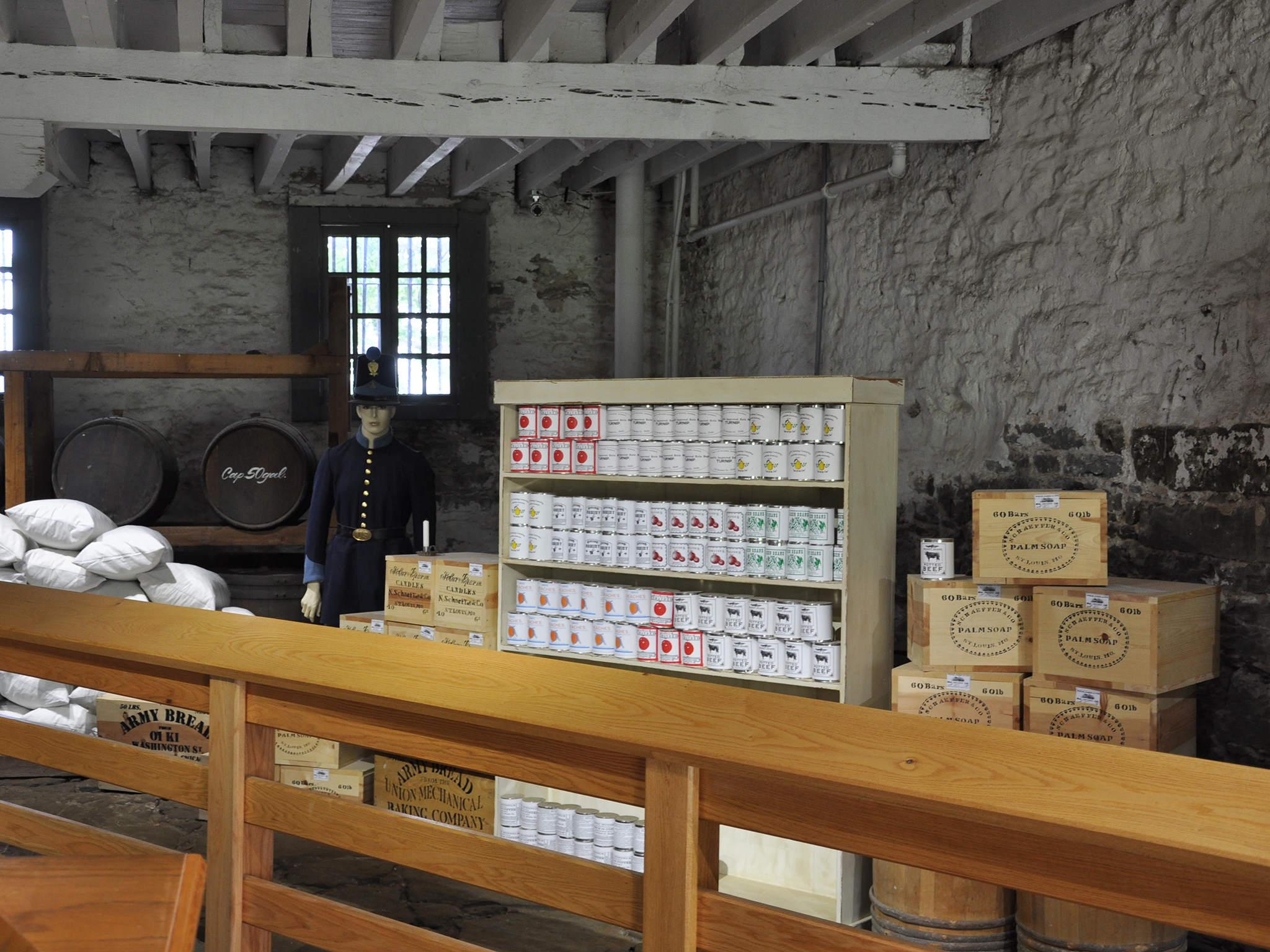
Commissary 771 words. The interior of the commissary has been arranged to show aspects of the building's historical use. A smooth flagstone walkway leads into the space, and then curves around to the left. Wooden railings on either side of the wide path guide your way. There are two wayside panels mounted on the railing: One to your left just as you enter and the other on the right just after the bend in the walkway. They are described in subsequent messages. On the left side of the walkway are two wooden chairs with hoop backs and spindles, a couple of small tables, and a twin bed. Two oil lamps rest on a wooden mantle above a fireplace on the far wall. A small area rug sits on the stone floor. The stone walls and wooden ceiling are painted white. On the right side of the walkway, boxes and barrels are piled high, and rows of canned goods fill a rack of wooden shelves. A mannequin dressed in a blue uniform stands at attention amid the supplies. At the end of the walkway are additional boxes and barrels that you can touch. Some have clear plexiglass covers, others have lift-up tops. They show some of the types of supplies that were once stored here. End of description. Wayside Panel – A Place to Call Home. The image on this wayside panel shows a fireplace set into a wall covered with grey floral wallpaper. Two wooden chairs face the fireplace, and three portraits sit atop the mantle beside an old-fashioned clock. Text on the left side of the panel reads: “In 1872, the Federal Court converted the Commissary into offices and living quarters. The most well-known residents to occupy the building were the Hammerslys from 1890 to 1896. While it was their home, they partitioned the first floor to accommodate their family of six that included Jacob and Mary, and their children Florence, Hugh, Parker, and Mary Louise. “Jacob was the Court Crier, while his daughter Florence served as Deputy Clerk, managing paperwork for Judge Parker. Florence was also an avid poetry writer. Growing up in the commissary did have advantages. Against his father’s wishes, Hugh would hurry from school to watch executions on the gallows from the second floor. “How would you like to have lived here?” End of text. The portraits on the mantle are identified, from left to right, as Jacob Hammersly, 1837-1900; Florence Hammersly, 1868-1950; and Hugh Hammersly, 1878-1958. Text below lists all of the commissary residents: 1872-1880, Jailer Charles Berry lived on the first floor. 1880-1890, Judge Parker used the second floor for his offices. 1890-1896, Jacob Hammersly and family lived on the first floor. 1899, Building purchased by the city of Fort Smith. Wayside Panel: A Busy Supply Depot. 2 ¼ minutes. Fifth of five descriptions at this location. A single image covers this 3 ½-foot by 2-foot panel. The sepia-toned photograph shows four mules pulling a covered wagon. The commissary building is visible in the background, dappled by shadows from the nearby trees. Text along the top of the panel reads: “Citizens in the town of Fort Smith feared Indian attacks due to the increased native population being relocated into Indian Territory. City leaders used this unfounded fear to convince the Federal Government to build a new fort for protection in 1838. When Indian attacks did not occur, the Government decided to change the mission of the fort from defense to supply depot in 1845. “For a time Fort Smith was one of the most important frontier posts. It supplied the Army fighting in the Mexican American War (1846- 1848), and the forts in Indian Territory. Supplies shipped by wagon and steamboat included staples such as candles, flour, potatoes, salt pork, vinegar, hardtack, and whiskey. Deciding it was no longer needed, in 1871 the military abandoned Fort Smith.” End of text. Additional text under the horse and wagon reads: “Commissary officers purchased many perishable products, such as fresh vegetables and hay for work animals, from local citizens. Items too expensive to buy locally were shipped in by steamboat.” End of text. On the panel’s lower right, a map overlays the photograph. The map is titled “Key supply locations in Indian Territory.” It shows Arkansas, Texas, and the Indian Territory. Seven supply locations are marked, each with a blockhouse shaped icon. The largest icon is Fort Smith, on the border between Arkansas and the Indian Territory. The other six are all located within the Indian Territory. They are: Fort Wayne, Fort Gibson, Fort Towson, Fort Cobb, Fort Arbuckle, and Fort Washita. End of description.
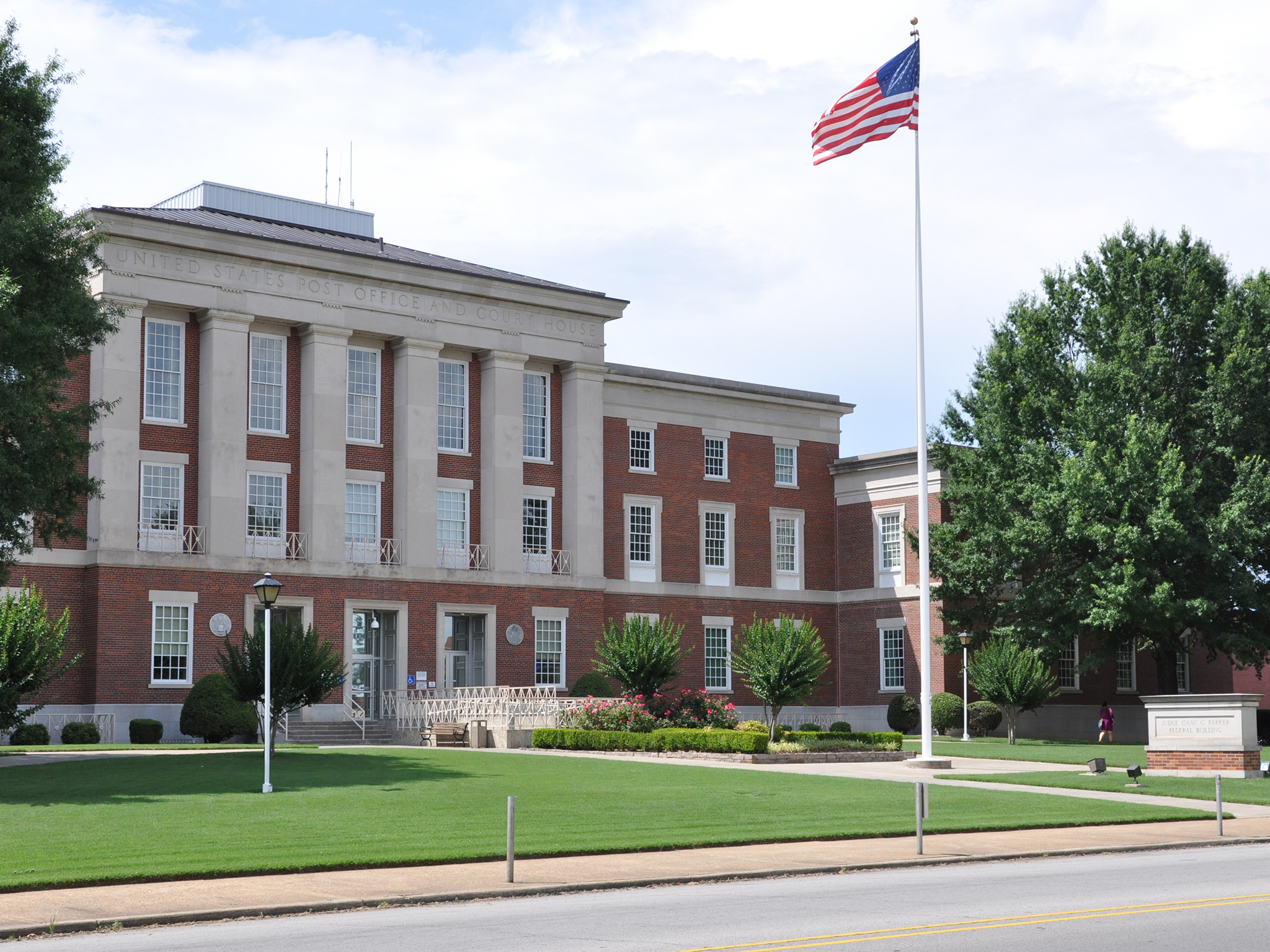
Judge Isaac C. Parker Federal Building and U.S. Courthouse. 201 words. The Judge Isaac C. Parker Federal Building and U.S. Courthouse is a red brick, Classical Revival style building with limestone trim. The central section is three stories high and 150 feet across. Two later additions, each two stories high and 60 feet wide, flank the central structure. The side wings project forward about 15 feet or so from the main building. Two wide walkways lead to three central doors, which are located up five steps. A series of ramps in front of the middle door also provide wheelchair access. Two additional walkways curve in toward the entrance from the right and left, inscribing a massive semi-circle on the grassy lawn. Above the main doors, six limestone pilasters rise two stories to the building's limestone cornice. Inscribed on the cornice are the words, "United States Post Office and Court House." Vertical and horizontal white lines divide each of the building's many windows into smaller square panes. There are between 16 and 32 panes per window, creating a latticework appearance. An American flag flies in front of the building on a white flagpole situated between the two central walkways. End of description.
Learn more about Major Stephen H. Long, the topographical engineer who chose Belle Point as the site of the first Fort Smith.
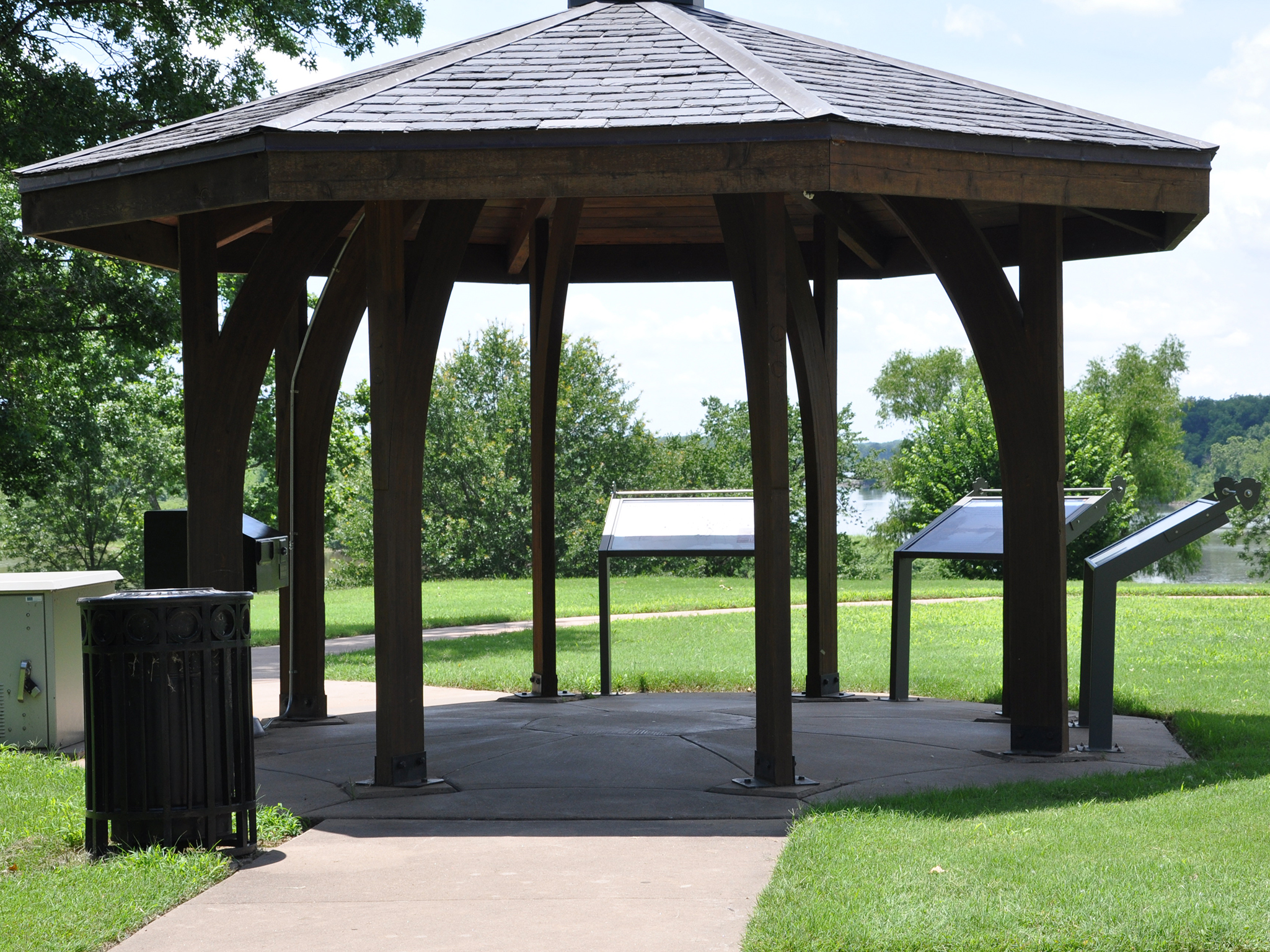
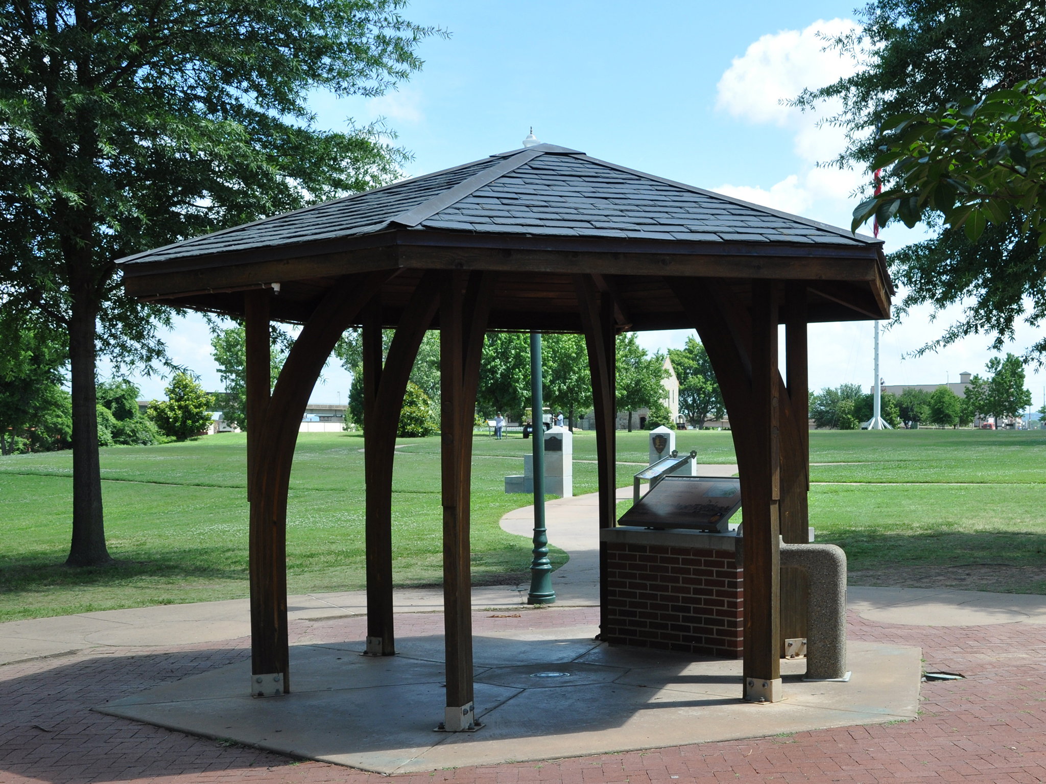
Wayside and gazebo near First Fort Smith. Area Description 270 words. This eight-sided gazebo is about 15 feet in diameter and open on all sides. It is accessed via the cement walkway that leads uphill slightly from the railroad tracks. It sits at the intersection with a smaller paved loop that circles the immediate area of the First Fort Smith. Eight thin wooden support posts are evenly spaced around the interior of the gazebo, and three wayside panels stand along the western edge of the structure. These panels are described in the following messages. To the left of the waysides is a black metal box on a stand. The box is about a foot on each side and three feet off the ground. A button on the side of the box triggers an audio message about the site. The gazebo floor is cement. The foundation stones of the first fort’s southeastern wall are about 30 feet west of the gazebo. Within the footprint of the first fort is a white flagpole from which hangs an American flag with 15 stars and 15 stripes. A cannon mounted on a green wheeled frame sits several feet to the right of the flagpole. A few trees dot the grassy hilltop, widely spaced. In summer, the landscape generally appears a lush green, but other times of the year, the grass may be yellow or brown. Beyond the flagpole, the ground slopes down toward the river. Numerous treetops poke up above the crest of the hill from the riverbank. Wayside Panel: Major Long Surveys the Western Frontier. 307 words. Second of 2 descriptions at this location. This panel features a large map of the United States, with zig-zagging yellow, green, and purple lines superimposed on it. The lines represent the expeditions of Major Stephen H. Long. Text on the left side of the panel reads: “Traveling mostly on foot, Major Stephen H. Long explored over 25,000 miles of the mid-west and northern United States. His team included artists and scientists to document natural resources. In 1817, he selected the location for the first Fort Smith. When he returned three years later, he was pleased with the construction progress. Information collected by Major Long contributed to the growth of the United States.” End of text. Below the text, a key identifies the colors and symbols on the map. The purple line represents Long’s 1816-1817 expedition. It starts in Washington, DC, winds through Fort Smith, and ends up at Fort Snelling, Minnesota. The green line is his 1819-1820 expedition. It starts in Pittsburgh, goes to Long’s Peak, Colorado, and ends in Fort Smith. The yellow line loops from Washington, DC, up to Fort Alexander in south central Canada and back to Rochester, New York, representing Long’s 1823 expedition. Other forts, cities, and mountains along the routes are also marked. In the bottom right corner of the panel is a reproduction of a painting by the artist Titian Peale. It shows Major Stephen H. Long on his Rocky Mountain Expedition of 1819-1820. In the painting, Long is portrayed as a young, slender man. He’s dressed in a grey military shirt and white pants, with a sword at his hip. Long stands against a pristine, romantic landscape, looking determinedly into the distance and pointing with an outstretched, gloved hand. The image is courtesy of Turak Gallery, Nottingham, Pennsylvania. End of description.
The Council of 1865 at Fort Smith was a meeting of different tribal and U.S. Government representatives.
Wayside Panel: Meeting of Nations – Area Description. 186 words. First of two descriptions at this location. This illustrated wayside panel stands along the outer edge of the cement path that encircles the Parade Ground. The panel faces the former courthouse/barracks/jail building. The building is about 10 feet in front of the panel when facing it. The building comprises two similar structures placed side-by-side. On the left side, the building has 2 ½ stories. The bottom floor is set partially underground. The visible portion of the ground floor has a white exterior and small square windows covered with bars. There are two full floors above it that feature larger rectangular windows and a red-brick exterior. Ten stairs lead up to a wooden porch at the level of the first full story. On the right side of the building, six barred windows span two full stories each. They are outlined in rough-hewn grey stone. Below them, a band of white several feet wide runs the length of the otherwise brick façade. Above the six tall windows, just below the roofline, is a row of decorative brickwork. Wayside Panel: Meeting of Nations – Panel Description. 309 words. Second of two descriptions at this location. A reproduction of a 2006 painting fills this panel. It shows 22 men huddled around a long table—some standing, some sitting. A few books and several large maps are spread out across the surface. Most of the men are dressed smartly in jackets, vests, and bowties; one wears a blue Union Army uniform. The men’s faces are illuminated by a single unseen light source. Text below reads: “The Fort Smith Council was held in this building in September 1865. To establish relations following the Civil War, delegates of twelve Indian nations met with President Andrew Johnson’s representatives. Bitterly divided, Indians had fought for both sides in the war, but the United States now treated them all as defeated enemies. Tribes were told their rights had been forfeited, their slaves must be freed, and their property could be confiscated. “The Council ended with little resolved. Not expecting to sign treaties, and concerned that tribal sovereignty was at stake, the Indians simply pledged allegiance to the United States. A year later in Washington, D.C., tribes signed separate treaties with the federal government.” End of text. Text to the right of the image lists the nations represented in the painting: Cherokee Chickasaw Choctaw Comanche Muscogee (Creek) Osage Quapaw Seminole Seneca Shawnee Wichita Wyandotte United States On the bottom left is a black-and-white photograph of General Albert Pike. He has long grey hair and a white beard. The text reads: “Confederate General Albert Pike recruited tribal nations to fight for the South in the Civil War. Whether to fight for South or North caused deep rifts affecting tribes for years to come.” On the bottom right is a portrait of Chief Allen Wright, a young man with short dark hair and a bowtie. The text reads: “At the Fort Smith Council, Choctaw Chief Allen Wright suggested the term ‘Oklahoma.’ Combining two Choctaw words to mean ‘land of the red man,’ it was this Council’s most lasting result.” End of description.
Memorial Wall. 241 words. Two rough stone segments of wall, each about 10 feet long and 5 feet high, angled away from the path that continues into the site. A metal plaque is affixed to the right-hand wall where it abuts the walkway. The plaque is about 3 feet off the ground and approximately a foot square. A semi-circle at the top of the plaque contains a relief image of spoked wheel, the insignia of the Daughters of the American Revolution. The plaque reads: "This memorial, built of the original stones, marks the location of the fort erected in 1838-1842 for protection against the Indians. The wall was 12 feet high and 2 feet thick with port holes about 4 feet apart. The main buildings in the enclosure were the commissary, two officers' headquarters, the quarter-master's headquarters and the soldiers' barracks, afterwards the United States Court presided over by Judge I. C. Parker of the Western District. Erected in 1930 by the Martha Baker Thurman Chapter, Daughters of the American Revolution, Dedicated 1936." End of text. The paved path continues on and curves right, through a flat grassy field. About 150 feet ahead is a two-and-a-half story red-brick building with a black pitched roof. This is the former barracks and courthouse. Today it serves as the Park Service visitor center. You're facing the long side of the rectangular building, which is about 150 feet from end to end. End of Description.
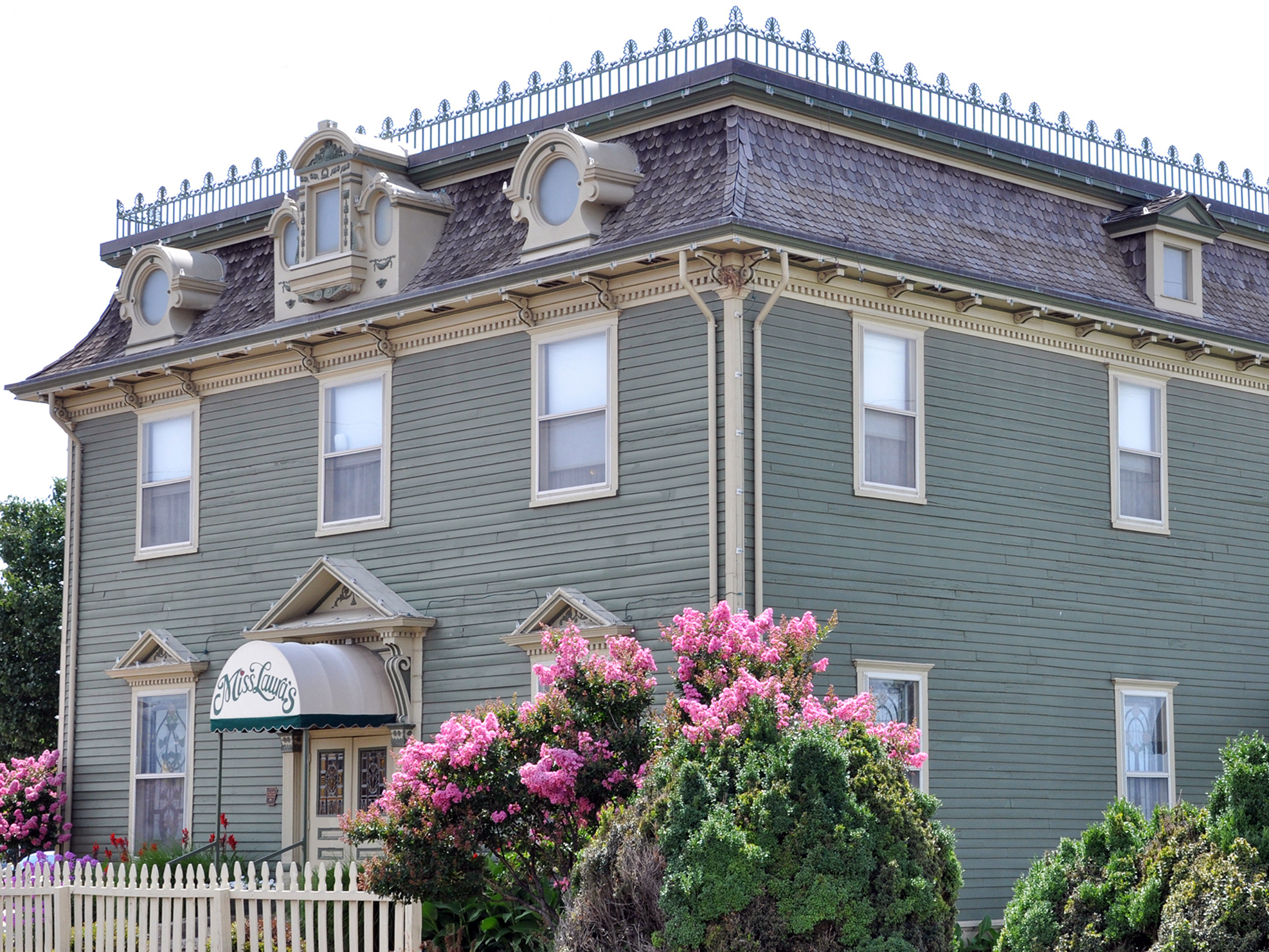
Miss Laura's Visitor Center. 185 words. Miss Laura's is a 2½-story Victorian-style house, painted cucumber-green with white and mustard-yellow trim. It is Fort Smith's official welcome and information center. The structure measures approximately 60 feet by 40 feet, oriented southeast to northwest. The building has a number of decorative flourishes, include stained-glass in several of the lower windows and elaborate dormers surrounding some of the top-floor windows. A black wrought-iron fence runs along the edge of the mansard roof. Miss Laura's is located at the south corner of B Street and Riverfront Drive, about two tenths of a mile north of Fort Smith National Historic Site. The building's main entrance is on the short southeast side, facing the railroad tracks, which run past at a distance of about 25 feet. There are two steps up to the double-doors. Another entrance is located on the long, northeastern side that fronts B Street, and a ramp leads up along the exterior wall to that door. To the southwest of the building is a large parking area that can be accessed from A Street. End of description.
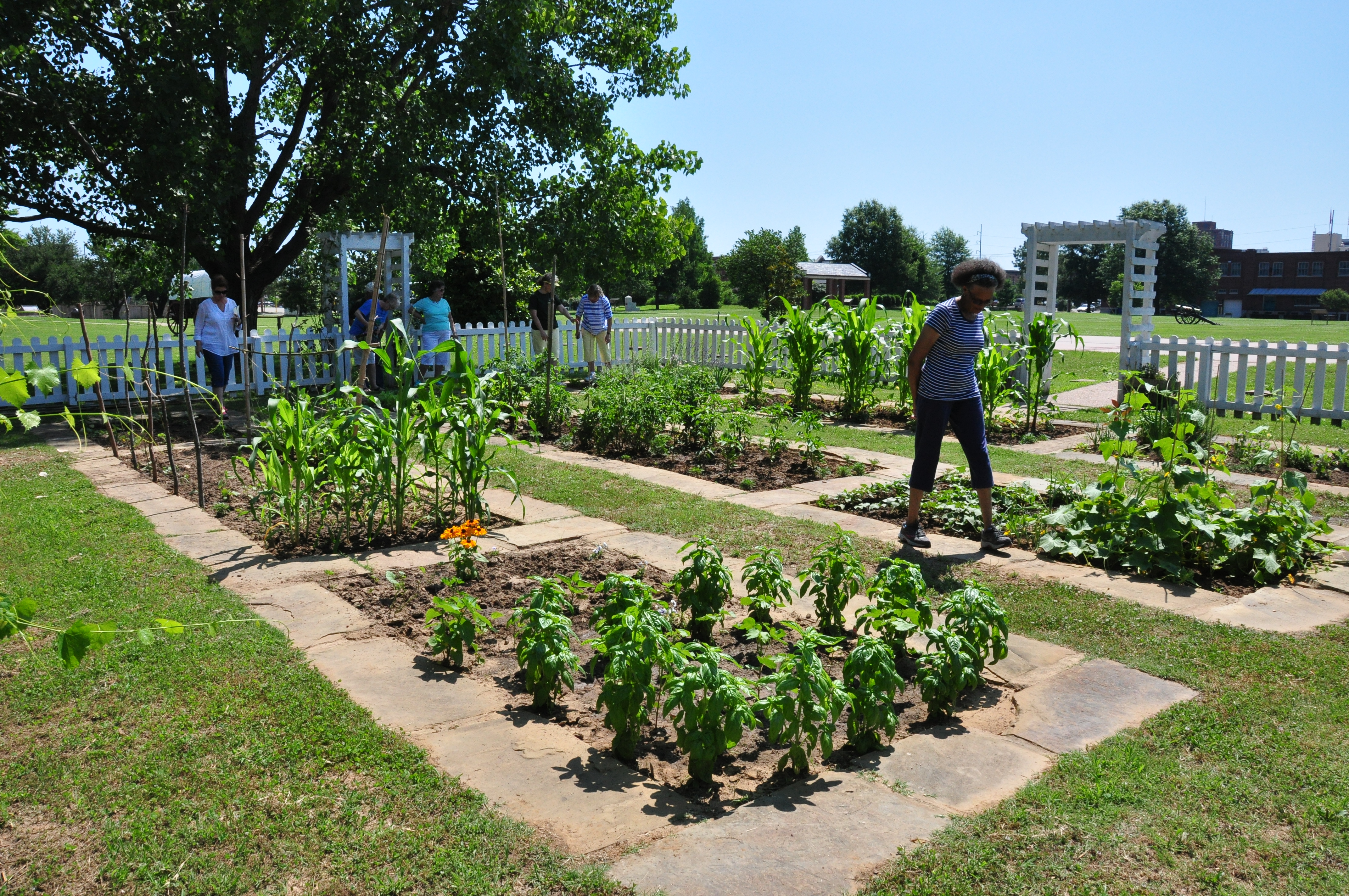
The Officers' Garden is a recreation of an 1860s garden at Fort Smith National Historic Site.
Officers' Garden. 437 words. Area descriptions at this location. Behind the site of the officers' quarters is a recreation of the officers' garden, connected to it by a short cement walkway. A low, white picket fence surrounds the roughly 30- x 30-foot garden on three sides. You can enter the garden through an arbor in the middle of each side. Rose bushes grow around the arbors. Inside the garden, rectangular plant beds are surrounded by small flagstones. To the right of the garden, as you face it from the Parade Ground, two backless wooden benches sit beside a large shade tree. Beyond the garden, a narrow strip of stone set into the grass marks the former location of the fort wall. Twenty or thirty feet beyond that are the railroad tracks. These are active tracks, so please be alert and listen for train horns. Wayside Panel: Officers' Garden. This 2-foot by 3 1/2-foot panel provides context about the garden that once graced this site. Set against a yellow background is a large colorized photograph of the Fort Smith Officers' Quarters, circa 1864. The photo shows a two-story brick building with a pitched roof and six chimneys. Twelve brick columns support open porches that run across the long façade on both the first and second floors. A white picket fence encircles the building, and several small bushes and flowers adorn the structure. Above the image is a quote from Mary Rutherford Cravens recalling Fort Smith in the 1850s. It reads: "The walls were almost hidden by a wealth of vines and foliage, and the enclosed space was as green as nature and care could make it. Beautiful flower beds were kept well tended by the soldiers and added greatly to the beauty of the grounds." End of text. Text to the left of the image reads: "A garden provided many benefits to the soldiers and their families at Fort Smith. Fresh vegetables in the garden behind the officers' quarters provided a healthy addition to their daily diet. Herbs were used as seasoning and medicine. Flowers brightened an otherwise monotonous fort life. Working in the garden was part of the daily routine for officers' wives and children. The garden also served as a pleasant gathering place for friends and family." End of text. Pictured on the lower left of the panel are the covers of three seed catalogs from the period. Text reads: "Seeds were either ordered from catalogs or sent by relatives." Seed catalog images are courtesy of the Smithsonian Institution Libraries, Washington, D.C. and the National Agricultural Library's Special Collections. End of description.
Brief history of Osage Nation in Arkansas Territory
Wayside Panel: Osage Nation – Area Description and Main Text. 353 words. First of two descriptions at this location. This wayside panel is located beside the cement walkway that runs parallel to the riverbank. The water’s edge is about 80 feet west of here, down a gentle grassy slope. The Poteau River flows in from the left, and a small bay bulges out from the river at 12 o’clock on the clockface. To the right of the bay, the Arkansas River streams in. It joins with the Poteau and continues off to your right. Deciduous forests populate the far banks of the rivers, and a few fallen trees, or snags, poke their branches up from the beneath water in a couple of spots. A park bench is approximately 10 feet to the left on the opposite side of the sidewalk. Beyond that, a steep hill rises up about 20 feet. The remnants of the First Fort Smith sits atop its plateau. The brown wayside panel features a block of text along its left side. On the right are several images that will be described in the next message. The main text reads: “Two hundred and fifty years ago the river you see here flowed through the homeland of one of the most powerful Indian nations in the center of the continent. They called themselves “Wah-Zha-Zhe.” Early French explorers spelled their name “Ouchage.” Osage people lived and hunted from the woodlands and rich river bottoms of present-day Missouri and Arkansas to the open plains of Kansas and Oklahoma 250 miles to the west. “Changes came fast and furious after France sold the Louisiana Territory to the United States in 1803. Thousands of Cherokee had already moved into this region because white settlers were flooding into the Cherokee lands in Georgia, Tennessee, and the Carolinas. Fighting broke out. Then the U.S. Army set up a garrison here at Fort Smith to try to keep the peace. “Osage leaders worried that crowding would lead the U.S. Government to demand that they give up more lands to make room for Indians being removed from the East. In less than a generation, their tragic forecasts became true.” Images and Additional Text. 330 words. Second of two descriptions at this location. To the right of the main text, a full-color image takes up most of the rest of this 3 ½-foot by 2-foot panel. The illustration shows the interior of a well-appointed neo-classical style room. On the right, a half-dozen men sit or stand behind a large wooden table. They wear dark suits and bow ties. Papers are strewn across the tabletop and three of the men hold quill pens. Nine Native American men sit or stand to the left of the table. They wear traditional dress. Stern expressions darken all the men’s faces. In the background, a young boy and his dog peak in through an open French door to see what’s happening. Beneath the image are five small maps laid out in a horizontal line. They’re dated 1800, 1808, 1818, 1825, and 1872 from left to right, and each shows the states of Missouri, Arkansas, Kansas, and Oklahoma in yellow. A red blob is superimposed on each of the maps. In the first map, the red color takes up more than half of the land area. As you move to the right, the red blob shrinks to just a small spot within the state of Oklahoma. Text below the maps reads: “In 1808 the Osage received $7,500 in trade goods for giving up claim to 200 miles of Missouri and Arkansas. The pressure increased. Years later the Osage ceded more lands in Kansas, Oklahoma, and Arkansas. After 1872, the Osage reservation shrank to the size of a single county in the northeast of Indian Territory.” End of text. To the right of the maps is an illustration of a seated woman holding an infant. Text below reads: “Today more than 16,000 Americans identify themselves as Osage. About 10,000 are enrolled members of the tribe. While looking to the future, the Osage Nation still remembers its past, a crucial part of American history.” End of description.
Regiment of Riflemen fort life on the western frontier.
Wayside Panel: Pioneering Soldiers. 358 words. This spot provides a commanding view of the intersection between the Arkansas and Poteau Rivers. The Arkansas flows toward you and off to the right, while the Poteau meets it from the left. The water's edge is down the hill just in front of you, about 150 feet away. There, a rocky outcropping extends into the water another 30 feet or so. If you'd like to take rest here, there is a park bench on a concrete slab a few feet in front of you as you face the water. An oak tree to your left provides shade. The image on this wayside panel shows a soldier enjoying roughly the same view from his own shady perch. It's a reproduction of a painting by Samuel Seymour. He was one of two artists who accompanied Major Stephen H. Long's western expedition. Seymour painted it in 1821, and it's the only known image of the first Fort Smith. The painting shows a soldier seated on a wooden stool. We see him from the back, facing toward the water. To his left is a wooden building-presumably the fort itself. He rests in the long shade of the building; the sun, it seems, is setting in the southwestern sky. A grey cannon sits idle on the edge of the hill in the middle-ground; next to it, another soldier appears to be standing guard, his rifle resting on his shoulder. The text reads: "In 1817, the Rifle Regiment arrived at Belle Point on the western edge of the American frontier. They realized how isolated they were when the first year passed without receiving food, supplies, or pay. In addition to constructing the fort, building roads, hunting, gardening, and repairing worn uniforms and equipment, soldiers struggled to survive. Many died within the first year. Life for the soldiers would not improve for several years." Lower right corner of panel text reads: "Artwork: Painted by Samuel Seymour in 1821, Fort Smith is the only known image of the first fort. He was one of two artists that accompanied Major Stephen H. Long's western expedition (1819-1820)." End of description.
Riverfront Park. 208 words. Riverfront Park sits just north of Fort Smith National Historic Site on the banks of the Arkansas River. At the southern end of the park, under the Garrison Avenue Bridge, is a concrete performance stage. A green metal shelter with open latticework frame and brown metal roof covers the stage. North of the stage is an open, grassy space about the size and shape of a football field. A shallow stone amphitheater with terraced walkways rises just north of that, facing the stage. The amphitheater seats over 1,100 people and the open area in front of it can accommodate another 10,000 for performances and musical acts. Ramps on either side of the amphitheater provide access to all levels of the theater and to the gathering area below. Flowering bushes line the ramps, framing the amphitheater in red and pink during the spring and summer. North of the amphitheater, a red-brick, green-roofed events building runs the width of the park from east to west. The narrow one-story structure is topped with two two-story towers. The towers rise on either side of a triple-arched pass-through that provides access to the amphitheater from a parking area at the north end of the park. End of description.
The north end officer's quarters was completed in 1852.
Second Fort Smith Officers Quarters #2. Two minutes. This is the site of one of two officers' quarters constructed and used during the second Fort Smith era, between 1838 and 1871. Today, all that exists is a cement pad about 75 feet by 20 feet - the same size as the original building foundation. The rectangular pad sits on the northwest edge of the Parade Ground, parallel to the oval-shaped path that rings the Parade Ground. A short cement walkway connects the officers' quarters with the oval path. Brick lines set into the cement pad mark the original locations of the building's interior walls. In addition, a dozen brick squares, about 1 foot by 1 foot each, have been placed in a line parallel to the front edge of the cement pad, about six feet in front of it. They mark the locations of the building's original columns. The squares stick up an inch or two from the grass, so watch your step if you venture off the path. As you face the front of the building site, the commissary building is about 100 feet to your right. To the left, about 50 feet away, is another cement pad, representing the site of the other officers' quarters. A wayside panel near its south corner provides additional information about the buildings. In between the two officers' quarters is a small stone mound. It's a cistern built during the second Fort Smith era. Behind the officers' quarters, a low white picket fence surrounds a re-creation of the officers' garden. A wayside panel near the oval walkway provides additional information about the garden. End of description.
Wayside Panel: Officers' Quarters - Main Text. 722 words. First of two descriptions at this location. This wayside panel is located near the south corner of one of two officers' quarters constructed and used during the second Fort Smith era, between 1838 and 1871. Today, all that exists from the building is a cement pad about 75 feet by 20 feet - the same size as the original building foundation. The rectangular pad sits on the western edge of the Parade Ground, parallel to the oval-shaped path that rings the Parade Ground. Brick lines set into the cement pad mark the original locations of the building's interior walls. In addition, a dozen brick squares, about 1 foot by 1 foot each, have been placed in a line parallel to the front edge of the cement pad, about six feet in front of it. They mark the locations of the building's original columns. The squares stick up an inch or two from the grass, so watch your step if you venture off the path. The wayside panel includes black-and-white images and text. The main text reads: "You are now standing on what was once Officer's Row at the second Fort Smith. From 1846 to 1865, two large buildings stood on the western edge of the parade ground and provided housing for officers and their families. Unlike the cramped quarters of the enlisted men's barracks, there was a degree of privacy here. Large front and back porches, yards, and gardens surrounded by picket fences provided further domestic comforts. "Fire destroyed both Officers' Quarters in 1865 and 1870. In 2000, the National Park Service placed the concrete pads here to show the approximate locations and floor plans of both buildings." End of text. The images and additional text are described in the next message. Wayside Panel: Officers' Quarters - Images. Three minutes. Second of two descriptions at this location. On the upper right-hand corner of this panel is a faded black-and-white photograph of the officers' quarters. The photo shows a two-story building with a pitched roof and six chimneys. Twelve brick columns support open porches that run across the long façade on both the first and second floors. A white picket fence encircles the building, and a man stands near the gate. Several small trees shade the front of the building. Below the image is the following quote from Mary Rutherford Cravens recalling "Social Life in the Garrison": "The great front porches were common rendezvous for the officers, their families and friends, and we used to delight in being there to watch the soldiers drill, hear the bugles' shrill call, and listen to the fine concerts by the army band on the parade grounds. The hospitality of the officers and their wives was unstinted, and many delightful functions were enjoyed by friends from the town and surrounding country." End of text. Below this is another photograph. This one depicts Captain Samuel Sturgis, Commander at Fort Smith from 1859 to 1861, along with his family. The Captain stands on the left, in uniform, his right hand tucked into his shirt. His wife sits in front, her floor-length skirt billowing. Their three children stand beside her, nearly expressionless. The photograph is from the Collection of the New-York Historical Society. Text beside it reads: "Officer's wives and children shared the trials and tribulations of military life with their husbands and fathers. At Fort Smith, Sturgis' son, Jack, was badly burned when two other boys accidentally exploded twelve pounds of gunpowder. Jack carried a facial scar until his death as a lieutenant at the Battle of Little Bighorn in 1876." End of text. To the left is a drawing of the Fort Smith cistern, which is located about 80 feet to your north. The drawing shows a small dome of stone and mortar protruding above ground level with a large subterranean storage tank below it. Gravel covers the bottom of the storage area, with water filling about half of the remaining space. Text beside the picture reads: "The Cistern - Following the Civil War, the U.S. Army constructed a dome-shaped cistern between the two officer's quarters. This underground storage tank is 22 feet deep and holds 55,000 gallons of water. The cistern, enlisted men's barracks, and the commissary are the only structures remaining from the second Fort period, 1838-1871." End of description.
In 1821, the Osage and the Regiment of Riflemen at the first Fort Smith engaged in a tense standoff.
Wayside Panel: Request Denied. 314 minutes. From this spot on the cement path that circles the immediate site of the First Fort Smith, you face west toward the Arkansas River. The Poteau River joins it from the south. A row of trees along the riverbank partially obscures the view of the water. You’re at the edge of a hill that slopes down about 150 feet to the water’s edge. Just to your left are some of the archaeological remains of the fort—a stone foundation built into the crest of the hill. Further down the hill near the water’s edge is the Trail of Tears Overlook, which features a series of wayside panels describing the historical travails of the local Indian nations. The panel shows an artist’s rendition of the first Fort Smith. The view looks west from a slightly elevated position. This allows us to peer inside the stockade, where groups of soldiers drill and fire cannons. A small band of Native Americans confer with a man in uniform. The Arkansas and Poteau Rivers are visible in the background, but unlike today, the rocky shoreline is clear of trees. Text above the image reads: “In the spring of 1821, Osage leader Bad-Tempered-Buffalo appeared across the Arkansas River with 400 warriors in war paint. He and seven warriors crossed the river requesting gunpowder and permission to hunt on Cherokee land. Acting fort commander, Lieutenant Martin Scott, refused both requests. The Osage left the fort having received the answer they expected. “In full view, the Osage cut trees, built rafts, and appeared ready to attack. Outnumbered ten to one, Lt. Scott, ordered the fort’s two cannons prepared for battle. After seeing this, the Osage left without incident. According to Osage oral tradition, Bad-Tempered-Buffalo’s actions were a bluff intended to scare the nearby Cherokee, intimidate the temporary commander, and reaffirm the Osage presence.” End of description.
The Arkansas State Militia gained control of Fort Smith in 1861.
Wayside Panel: War Begins - Area Description. 133 words. First of two descriptions at this location. This wayside panel stands at the edge of the Parade Ground, along one of the longer sides of the oval-shaped cement path that encircles the space. The Fort Smith flagpole is about 50 feet away, near the center of the Parade Ground. It's at approximately 1:00 on the clock face when facing the panel. Atop the 100-foot flagstaff is a large American flag with just 37 stars. Beyond the flagpole at a distance of about 100 yards is the grey stone commissary building. At approximately 5:00 on the clock face when facing the panel is the former jail/courthouse/barracks building-now the Visitor Center. Panel Description. 277 words. Second of two descriptions at this location. This panel features a large, color photograph of reenactors hoisting a Confederate flag up the Fort Smith flagstaff. The light grey commissary building is visible behind them. The flag has two red stripes, one white stripe, and seven stars on a field of blue. Text explains that the flag contained just seven stars in April 1861 because Arkansas had not yet seceded from the Union. Text below the image reads: "At the beginning of the Civil War, amid the firing of cannon and the cheers of the people,' a local newspaper reported, Arkansas State Militia raised the Confederate flag and took control of Fort Smith on April 23, 1861. "With the Confederate victory in South Carolina at Fort Sumter, the U.S. War Department ordered all southern forts abandoned. Despite pleas of concerned citizens, U.S. troops (later called Union troops) left Fort Smith just an hour before state militia arrived. The transition took place without conflict. "While Arkansas militia troops controlled the fort, citizens of Fort Smith and the surrounding region remained deeply divided. Many pro-Unionists kept silent, suppressed their loyalties, or left town. After Union victories at Gettysburg and Vicksburg in July 1863, followed by Confederate defeat west of Fort Smith at Honey Springs, Union forces reclaimed Fort Smith in September 1863." End of text. To the right of the photograph is a sepia-toned reproduction of a newspaper clipping. A series of headlines reads: "Arrival of State Troops! Fort Smith Evacuated by the United States troops in the Night. They Retreat into the Indian Country. The Post Occupied by the State Troops!" End of Description.
North entrance to park and wayside panel 433 words: Area Description. One minute. From this wayside overlooks the length of the Fort Smith Parade Ground. The cement path just to the left of the wayside leads to a long oval walkway that runs all the way around the Parade Ground. Straight ahead, in the middle of the Parade Ground, is the Fort Smith flagstaff. An American flag with 37 stars waves from its 100-foot tip. To the left of the flagpole is the park service visitor center. Twenty feet to the left of this wayside, is the site of the former guardhouse, and about 75 feet to the right is the commissary building. A one-foot wide stone strip set into the grass running between the two buildings marks the location of the former fort wall. Panel Description. This 2-foot by 3 ½-foot panel has Spanish and English text on the upper half and one large image filling the background. Below the text, filling the bottom half of the wayside is an aerial photograph looking south over the park grounds. Two railroad tracks running north-west through the photograph split the park into two portions. The area to the right of the railroad tracks is wooded with clear areas and trails. The area to the left of the tracks contains the parade ground, commissary, flagpole, visitor center, and gallows. Four smaller circles act as a magnifying glass zooming in and highlighting significant features. The small circle on the top center is a close-up the of sidewalk wrapping around the foundation stones and blockhouse text read “First Fort Smith”. The small circle in the lower right corner is a tan stone and grey roofed building text reads “Commissary”. At the bottom center is a red dot with text that reads “You Are Here”. The circle in the lower left corner is a southern end of a red brick building and text reads “Visitor Center”. At the upper left is the final small circle containing a white raised platform with slanted roof and text reads “Gallows”. Text on the left is a Spanish translation of the English on the right. English text reads Exploring Fort Smith There are several areas to explore at Fort Smith National Historic Site. Sidewalks offer access to a variety of historic features. Highlights include the gallows, commissary, and visitor center (former barracks, courthouse, and jail). Stroll along the River Trail beside the Arkansas and Poteau Rivers. Discover the oldest part of the park at the foundation of the first Fort Smith. Spanish Text reads Explorando Fort Smith Hay varias áreas para explorar en el Sitio Histórico Nacional de Fort Smith. Las aceras ofrecen acceso a una variedad de características históricas. Los aspectos más destacados incluyen la horca, el comisario y el centro de visitantes (antiguos cuarteles, juzgados y cárcel). Pasee por el sendero del río junto a los ríos Arkansas y Poteau. Descubra la parte más antigua del parque en los cimientos del primer Fort Smith. End of description.
Wayside Panel: Exploring Fort Smith east entrance 447 words. Area Description. This wayside panel is just to the left of a wide cement path that leads into the Fort Smith National Historic Site from the east. About 20 feet behind you, an outer gateway to the site features two stepped stone pillars about 4 feet high on either side of the walkway. A few feet in front of you is an inner gateway: Two rough stone segments of wall, each about 10 feet long and 5 feet high, angled away from the path that continues into the site. Panel Description. This 2-foot by 3 ½-foot panel has Spanish and English text on the lower half and one large image filling the background. Above the text, filling the top half of the wayside is an aerial photograph looking southwest over the park grounds. Two railroad tracks running north-south through the photograph split the park into two portions. The area above the railroad tracks is wooded with clear areas and trails. The area below the tracks contains the parade ground, commissary, flagpole, visitor center, and gallows Four smaller circles act as a magnifying glass zooming in and highlighting significant features. The small circle in the upper right is a tan stone with gray roofed building text reads “Commissary”. To the left of center in the image above the text is a red dot with text that reads “You Are Here”. The circle in the lower left corner is a southern end of a red brick building and text reads “Visitor Center”. At left center in the small circle is a white raised platform with slanted roof and text reads “Gallows”. The final small circle on the upper left is a close-up the of a sidewalk wrapping around the foundation stones and blockhouse text read “First Fort Smith”. Text on the left is a Spanish translation of the English on the right. English text reads Exploring Fort Smith There are several areas to explore at Fort Smith National Historic Site. Sidewalks offer access to a variety of historic features. Highlights include the gallows, commissary, and visitor center (former barracks, courthouse, and jail). Stroll along the River Trail beside the Arkansas and Poteau Rivers. Discover the oldest part of the park at the foundation of the first Fort Smith. Spanish Text reads Explorando Fort Smith Hay varias áreas para explorar en el Sitio Histórico Nacional de Fort Smith. Las aceras ofrecen acceso a una variedad de características históricas. Los aspectos más destacados incluyen la horca, el comisario y el centro de visitantes (antiguos cuarteles, juzgados y cárcel). Pasee por el sendero del río junto a los ríos Arkansas y Poteau. Descubra la parte más antigua del parque en los cimientos del primer Fort Smith. End of description.
Gazebo South Entrance 490 words. Area Description. A wooden gazebo stands just to the north of the parking area. This is one of several entrances to Fort Smith National Historic Site. The six-sided structure is about 15 feet in diameter and open on all sides. Inside is a wayside panel and a water fountain. Six thin wooden support posts are evenly spaced around the edge of the interior. The gazebo floor is cement; around that, the ground it is also cement. About 10 feet to the southwest is a free-standing bulletin board that displays park safety messages and program updates. A paved walkway leads off to the west toward the site of the first Fort Smith. The walkway crosses an active railroad track after about 40 feet, so please be careful. About 150 feet to the northeast of the gazebo is the former barracks-courthouse-jail building-now the park's visitor center. It's a 2 ½-story, red brick building about 150 feet from end to end. It's topped with a pitched black-shingle roof. The Fort Smith flagpole stands just to the left of the building, in the middle of an open area known as the Parade Ground. Panel Description. This 2-foot by 3 ½-foot panel has Spanish and English text on the upper half and one large image filling the background. Below the text, filling the bottom half of the wayside is an aerial photograph facing west northwest of park grounds. Two railroad tracks running north-west through the photograph split the park into two portions. The area to the left of the railroad tracks is wooded with clear areas and trails. The area to the right of the tracks contains the parade ground, commissary, flagpole, visitor center, and gallows. Four smaller circles act as a magnifying glass zooming in and highlighting significant features. The small circle on the lower left is a close-up the of sidewalk wrapping around the foundation stones and blockhouse text read “First Fort Smith”. The small circle in the upper right below the text a tan stone and grey roofed building text reads “Commissary”. The circle in the lower right corner is a southern end of a red brick building and text reads “Visitor Center”. At the bottom center in the final small circle is a white raised platform with slanted roof and text reads “Gallows”. Above the gallows circle is a red dot with text that reads “You Are Here”. Text on the left is a Spanish translation of the English on the right. English text reads Exploring Fort Smith There are several areas to explore at Fort Smith National Historic Site. Sidewalks offer access to a variety of historic features. Highlights include the gallows, commissary, and visitor center (former barracks, courthouse, and jail). Stroll along the River Trail beside the Arkansas and Poteau Rivers. Discover the oldest part of the park at the foundation of the first Fort Smith. Spanish Text reads Explorando Fort Smith Hay varias áreas para explorar en el Sitio Histórico Nacional de Fort Smith. Las aceras ofrecen acceso a una variedad de características históricas. Los aspectos más destacados incluyen la horca, el comisario y el centro de visitantes (antiguos cuarteles, juzgados y cárcel). Pasee por el sendero del río junto a los ríos Arkansas y Poteau. Descubra la parte más antigua del parque en los cimientos del primer Fort Smith. End of description.
Exploring Fort Smith (East Entrance) 448 words. Area Description. This wayside panel stands at the southeastern entrance to Fort Smith National Historic Site. The angled welcome panel is on the sidewalk just at the edge of the parking area. The panel stands 2 ½ feet off the ground on two metal legs. About 20 feet to the north are two stepped stone pillars on either side of a cement walkway that leads into the site. The pillars stand about 4 feet high at their highest point. They mark the spot where the path intersects the outline of the original fort wall. About 150 feet further north is a two-and-a-half story red-brick building with a black pitched roof. This is the former barracks and courthouse—now the visitor center. About 80 feet to the left when facing the visitor center is a white structure enclosed by a white, wooden gate – the gallows. Panel Description. This 2-foot by 3 ½-foot panel has Spanish and English text on the upper half and one large image filling the background. Below the text, filling the bottom half of the wayside is an aerial photograph facing west northwest of park grounds. Two railroad tracks running north-west through the photograph split the park into two portions. The area to the left of the railroad tracks is wooded with clear areas and trails. The area to the right of the tracks contains the parade ground, commissary, flagpole, visitor center, and gallows. Four smaller circles act as a magnifying glass zooming in and highlighting significant features. The small circle on the lower left is a close-up the of sidewalk wrapping around the foundation stones and blockhouse text read “First Fort Smith”. The small circle in the upper right below the text a tan stone and grey roofed building text reads “Commissary”. The circle in the lower right corner is a southern end of a red brick building and text reads “Visitor Center”. To the left of the visitor center circle is a red dot with text that reads “You Are Here”. At the bottom center in the final small circle is a white raised platform with slanted roof and text reads “Gallows”. Text on the left is a Spanish translation of the English on the right. English text reads Exploring Fort Smith There are several areas to explore at Fort Smith National Historic Site. Sidewalks offer access to a variety of historic features. Highlights include the gallows, commissary, and visitor center (former barracks, courthouse, and jail). Stroll along the River Trail beside the Arkansas and Poteau Rivers. Discover the oldest part of the park at the foundation of the first Fort Smith. Spanish Text reads Explorando Fort Smith Hay varias áreas para explorar en el Sitio Histórico Nacional de Fort Smith. Las aceras ofrecen acceso a una variedad de características históricas. Los aspectos más destacados incluyen la horca, el comisario y el centro de visitantes (antiguos cuarteles, juzgados y cárcel). Pasee por el sendero del río junto a los ríos Arkansas y Poteau. Descubra la parte más antigua del parque en los cimientos del primer Fort Smith. End of description.
Wayside Panel: Whiskey War – Area Description. One minute. First of two descriptions at this location. This wayside panel stands along the cement path that winds its way around the area of the First Fort Smith. If you’re facing the panel, your view is toward the west, overlooking a grassy knoll dotted with several trees widely spaced across the landscape. About 20 feet to the south, the cement walkway intersects with the path connecting the First Fort area and the Second Fort area. About ten feet behind this location, parallel to the walkway, are a series of active railroad tracks, so be alert and watch your step when venturing off the path. Wayside Panel: Whiskey War – Panel Description. Two minutes. Second of two descriptions at this location. This panel is illustrated with a single night-time image. On the right side of the picture, three men stand in the doorway of a wooden building. They appear to be in their bed-clothes. One holds aloft a lantern while the other two brandish their guns angrily. The wooden structure above the doorway is fractured and smoking. Facing them from the left are four men with a cannon. They are depicted in shadow, but wisps of smoke are visible wafting up from the cannon barrel. Text above and below the image reads: “By 1833, a small community had developed next to the fort. Out of the six shops, five were taverns. As the fort’s commanding officer, Captain Stuart’s responsibilities included stopping the illegal sale of whiskey to Indians and soldiers. “After two months at Fort Smith, he observed that his soldiers were becoming the worst in the Army due to excessive drinking. The Bigelow brothers’ tavern was the scene of most of the trouble. In August, Captain Stuart confronted the brothers. During the argument he was severely beaten with his own cane. That night an explosion rocked the tavern. The Bigelows woke up and found a gaping hole in their wall, and four soldiers standing outside around a smoking cannon. “The brothers demanded that Captain Stuart arrest the four soldiers. Stuart replied that the soldiers were under the influence of bad whiskey purchased at their tavern, and that they could not be found. Unfortunately, the struggle against illegal whiskey trading continued through the rest of the 19th century.” End of discussion.
After the U.S. Army closed Fort Smith in 1871, the federal court converted the guardhouse into a jail for women.
Wayside Panel: Women's Jail, 1872-1888 - Main Text 240 words. First of two descriptions at this location. You're facing southeast from the site of the former Fort Smith guardhouse. The view is of a grassy field with some modern city buildings several hundred feet in the distance, including the Fort Smith Museum of History. About 150 feet to your right is the former barracks and federal court building, now the National Park Service visitor center. The angled wayside panel is approximately 36 inches wide and 24 inches high. It features three black-and-white images set against a beige background. They'll be described in the next message. The main text at the top of the panel reads: “After the U.S. Army closed Fort Smith in 1871, the guardhouse served the Federal Court for the Western District of Arkansas. It remained in use as a jail, detaining primarily women suspected or convicted of federal crimes until 1888. At that time, the court moved quarters for female prisoners into the courthouse/jail building. Although not as numerous as their male counterparts, female prisoners were no novelty in Fort Smith. They committed the same crimes as men in the Indian Territory, ranging from the illegal sale of whiskey to murder. When convicted, they received the same sentences – fines, jail time or death by hanging. From 1873 to 1874 the guardhouse also briefly functioned as “Death Row” by holding the men condemned to die on the gallows.” Wayside Panel: Women’s Jail, 1872-1888 – Images and Additional Text. 290 words. Second of two descriptions at this location. On this panel’s upper right is a front view of the guardhouse taken from the original 1849 construction drawings. It shows a one-story rectangular building with a high-pitched roof, a central doorway, two windows, two chimneys, and four columns in front—all symmetrically arranged. An 1894 fire severely damaged the guardhouse, but it probably remained standing until 1896. On the left-hand side of the panel is a black-and-white photo of a bearded man in a dark suit, white shirt, and cap. The text below reads: “Jail Guard Robert Jackson, circa 1896. During the time that the old guard house was used as a women’s prison, the U.S. Marshal had to hire additional guards to watch over female prisoners in the guardhouse. Working as a jail guard was considered very desirable, as guards were paid a fixed salary often much higher than that of a deputy marshal.” End of text. Finally, in the bottom center of the panel is a photograph of a woman sitting side-saddle on a dark horse. She looks grimly at the camera, wearing 19th-century clothing and a large pistol holstered at her hip. The text below reads: “Romanticized in the movies as a ‘Bandit Queen’ or ‘Lady Robin Hood,’ Belle Starr was neither. She had entered into a life of petty crime during the Civil War and continued in that vein until her murder in 1889. Belle was brought in front of Judge Parker on charges of horse theft in 1883, found guilty and sentenced to a year in the Detroit House of Corrections. It is likely that while awaiting trial, Belle Starr was imprisoned here.” End of description.
This building has evolved over time. Beginning in 1846, it was the enlisted men's barracks and dining hall. In 1872, it was converted to a courthouse and jail. A second, more modern jail was added in 1888. The last major change occurred between 1996-2000 when the buildings were renovated and exhibits added, making the building more accessible to visitors. The visitor center helps tell the story of Fort Smith from 1817 to 1896.
The loop around the Parade Ground is one quarter of a mile. It was the center of life at the fort from 1838 - 1871.
Become a Fort Smith BARK Ranger
Complete the Fort Smith BARK Ranger booklet so your pet can become an official BARK Ranger!
Become a Fort Smith Junior Ranger
Complete a Junior Ranger booklet to earn an official Fort Smith Junior Ranger badge!
Walk the River Loop Trail
The trail is open year round. No access to the river. No water or restrooms are located along the trail.
Tours
Count: 2
First Fort Smith
Discover the history of the first Fort Smith and the challenges faced by the soldiers who established it. The first fort site is located roughly 300 yards west of the visitor center at Belle Point, overlooking the Arkansas and Poteau Rivers. Take a moment to read the wayside panels and tap “Explore This Location” for more information at each stop.
Fort Smith During the Civil War
Discover the role Fort Smith played during the Civil War. Each stop will have a question to encourage conversations while on the tour.