Be advised that the NPS has issued alerts for this park.
Bridge access to Maryland Heights Trail CLOSED
The NPS will rehabilitate the stairway connecting the Goodloe Byron Memorial Footbridge to the C&O Canal NHP towpath. The stairway is CLOSED for approximately two weeks beginning September 22 while crews build a temporary stairwell. During that time, a shuttle will run between C&O Canal Lock 34 and Harpers Ferry National Historical Park Visitor Center. This will impact access to Maryland Heights, the Appalachian NST, and the Potomac Heritage NST.
Expect large crowds and high traffic volume on weekends
Big crowds and high traffic volume may cause the main parking lot on Shoreline Drive to fill and close for short periods of time. Check park social media channels for the latest updates.
Ongoing work on Lower Town buildings
Facilities staff are doing repair work on several buildings in Lower Town. Please follow signs for alternate entrances and heed temporary closures.
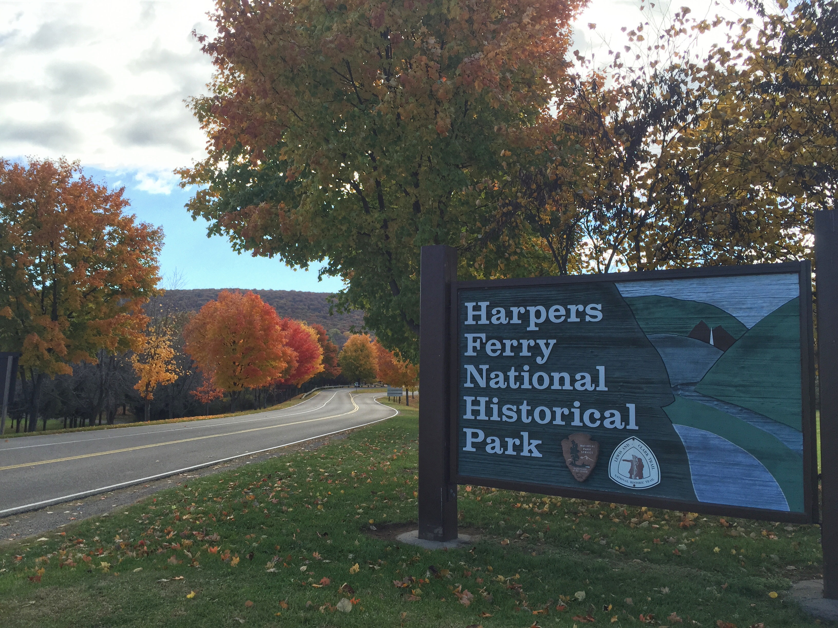
At the confluence of the Shenandoah and Potomac rivers, on the ancestral home of the Tuscarora and Shawnee people, lies Harpers Ferry. Here you can explore John Brown's Raid against slavery. Find your connection to the struggle for freedom, educa...
For a single, private vehicle. Excludes group tours and 7+ passenger vans. Entrance passes are valid for three consecutive days, beginning on date of purchase and are required in all park areas. Fees are payable at the Entrance Station near the park's visitor center, Bolivar Heights, Maryland Heights, Harpers Ferry Train Station, and River Access Parking Lot.
Entrance - Motorcycle
$15.00
Entrance passes are valid for three consecutive days, beginning on date of purchase and are required in all park areas. Fees are payable at the Entrance Station near the park's visitor center, Bolivar Heights, Maryland Heights, Harpers Ferry Train Station, and River Access Parking Lot.
Entrance - Per Person
$10.00
Persons arriving on foot or on bicycle are required to pay the per-person fee. Entrance passes are valid for three consecutive days, beginning on date of purchase and are required in all park areas. Fees are payable at the Entrance Station near the park's visitor center, Bolivar Heights, Maryland Heights, Harpers Ferry Train Station, and River Access Parking Lot.
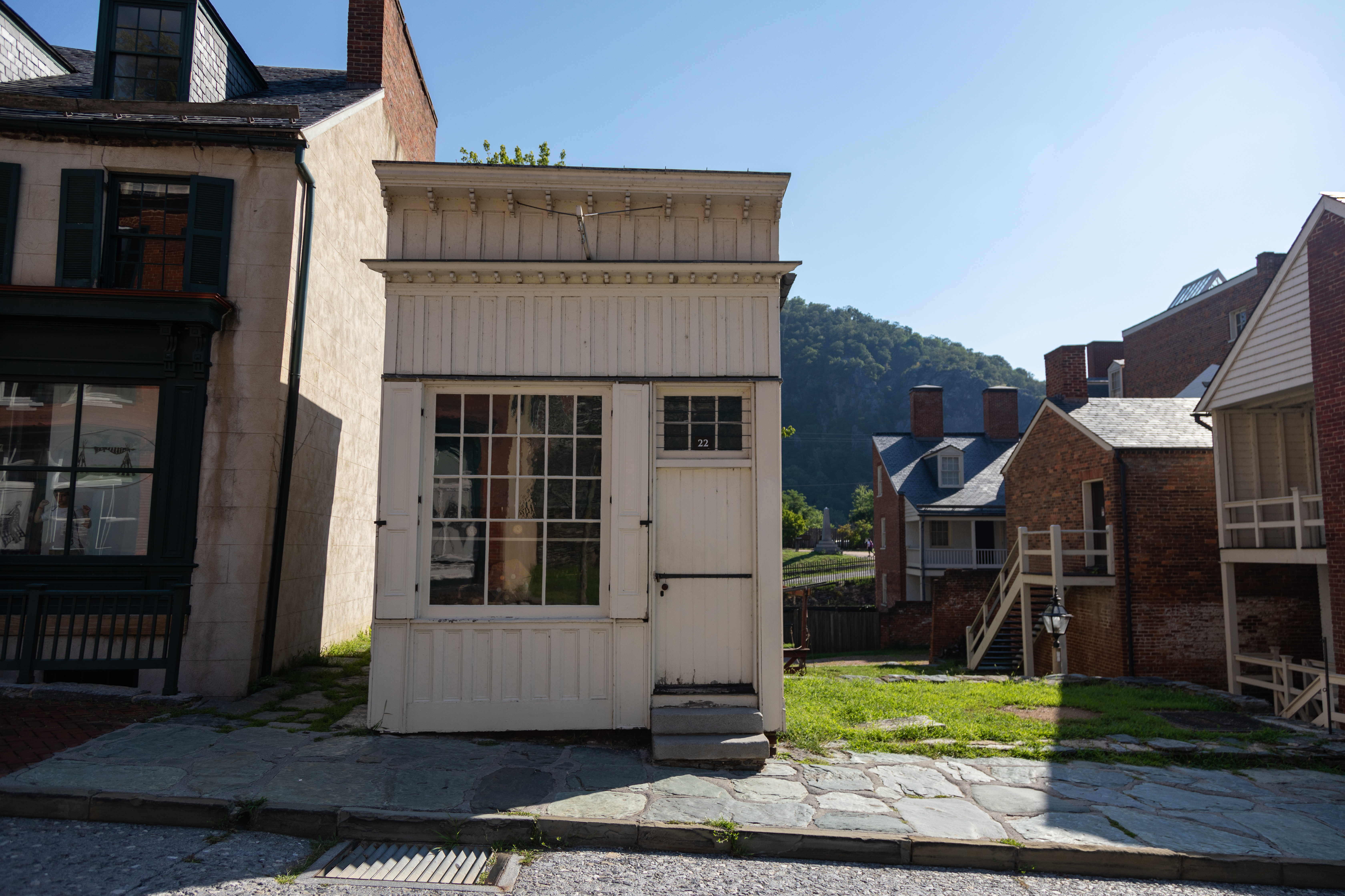
This exhibit shows a replica of the store that was run by the Burton family for almost 50 years. Visitors today can stop in and see clocks of the 1800s.
A. Burton: Fine Watch Repairing, exterior and interior. This narrow, single floor structure is sided in cream-colored painted vertical wood panels. A single doorway stands just to the right of a 5 foot by 7 foot window and a 6-paned window is mounted above the door. Together, the window and door make up almost the entire width of the front wall. Just above the door hangs a white sign outlined in blue. A drawing of a pocket watch is in the center of the sign and the words "A. Burton, Fine Repairing" are drawn in black. The sign is duplicated on the reverse side. Through the large front window, we see an assortment of watches and clocks. Six pocket watches are suspended on a gold and glass display stand shaped like a small Ferris wheel. We enter the building at the right over two stone steps on to the weathered wooden floor. A wall of Plexiglas to the left and along back prevents visitors from venturing into the workshop but allows for viewing into the small space beyond. A panel mounted on the wall to the right inside the doorway provides more information: A. Burton: Fine Watch Repair. Alfred Burton's watch repair shop probably opened in 1869 as part of a wave of new and reopened businesses in Harpers Ferry after the Civil War. Burton and his sons repaired and sold watches, clocks, jewelry, and spectacles in this building for nearly 50 years. Many objects in this room appear in Burton's ledger, reproduced at right. Archeologists discovered the marbles, inkwell, and slate pencil. Burton descendants donated the ledger, safe, workbench, and watch parts. Below is an 1875 Deed of Trust that provides clues to other shop contents:"... One Iron Safe, One Show Case, One time Piece Regulator, One Watch Bench, One Watch Pivot Lathe, One American Lathe, One Pair of Silver Smiths Rolls, One foot Lathe, One Pair of Fairbanks Counter Scales... One Set of Watch Tools, One Set of Watch Glass Draws, One case of Small draws for Watch Material." On the right of the panel, a tintype portrait of Alfred Burton, September 1865. He has a mid-length beard with no mustache and wears a long dark coat over a dark vest and herringbone pattern pants and holds a cane in his right hand. A caption reads: A Curiosity in the Window: "Mr. Burton... has a singular sort of mechanical contrivance in his store window, from which hangs half a dozen watches... and this contrivance keeps continually going round at the same solemn, blind horse rate... Citizens are beginning to complain of this; they say that it is having a bad effect on the brain of people who are obliged to look into the window." Spirit of Jefferson (a Charles Town newspaper), November 5, 1878. Looking into the workspace to the left, near the front window is a wood workbench covered with an assortment of hand-tools and small tins. Along the wall across from you, clocks of varied size, shapes, and styles adorn the shelves. And in the center of the floor, a countertop holds glass display cases filled with ornamental watch chains and jewelry and an array of pocketwatches. In the back-right corner of the room stands a round woodstove.
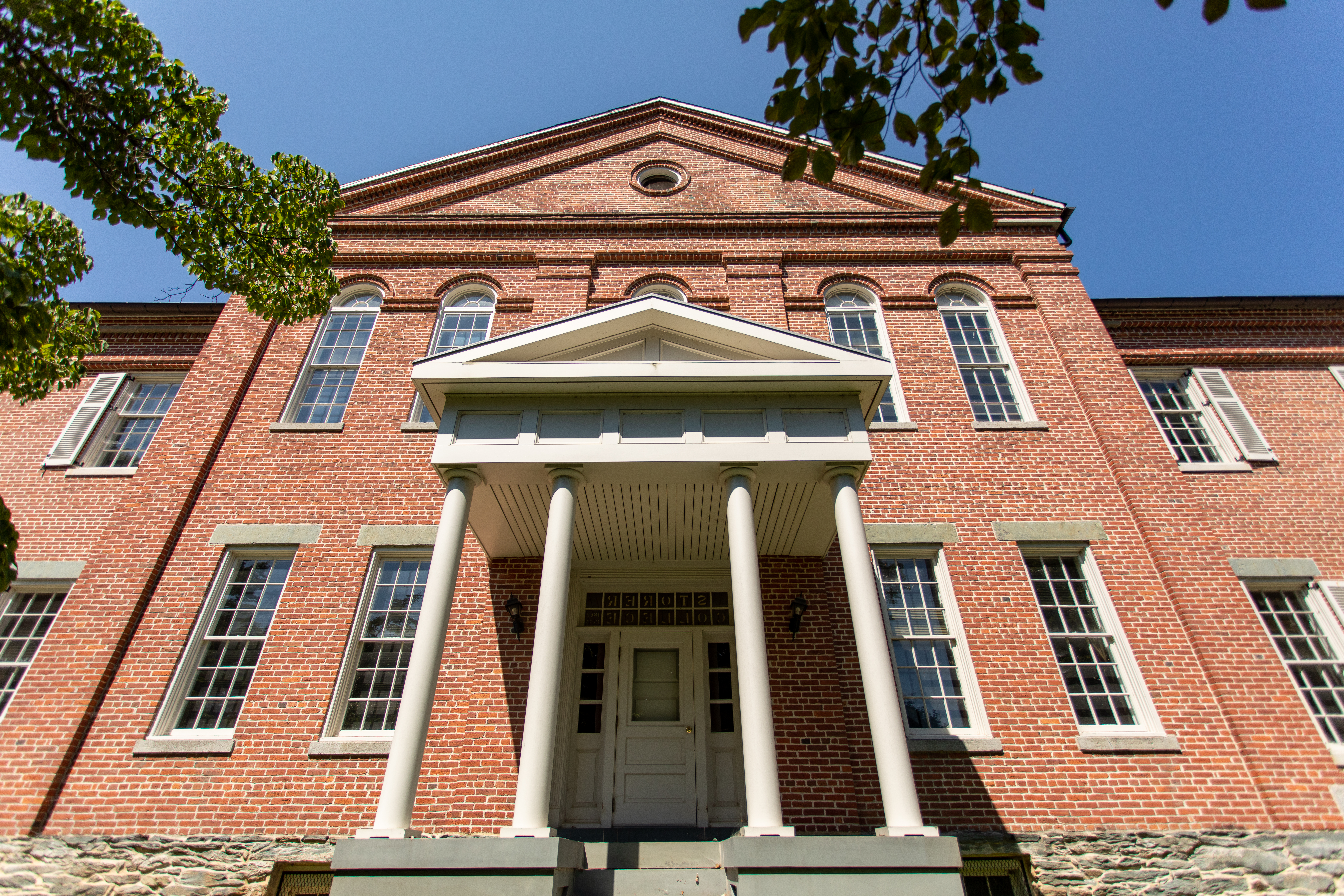
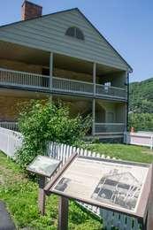
Built in 1848 as the armory superintendent's home, the house was used as officers' quarters during the Civil War. The building was conveyed to Storer College in 1869, replacing Lockwood House as school headquarters. After an addition in 1882, Anthony Memorial Hall contained the main library, museum, music rooms, chapel hall, lecture room, science laboratories and administrative offices. In 1906, the Niagara Movement met in this building. It now serves as a training center for
Stephen T. Mather Training Center. Welcome to the National Park Service's Stephen T. Mather Training Center at 51 Mather Place, formerly the home of Storer College's Anthony Hall. The front of the building faces east, toward the Harpers Ferry gap. At the back of the building is a parking lot for employees and visitors as well as a wheelchair accessible entrance to the building. The long three-story red brick building is built upon a three foot tall stone foundation. The middle section of the building rises to a point in the center with a round window in the gable above the second floor. Five tall Palladian windows line the second story. At the center of the first floor, a white portico stands upon a three-foot tall porch and frames a single white door with sidelights. Two 5 foot tall stone-capped windows are on either side. There is no walkway to the center door and this entrance is locked. A 30 foot tall flag pole is mounted in the ground just to the right of the middle entrance. The building extends on the left and right into non-gabled two-story tall wings, each with doorways framed under raised porticos. Along each wing, three shutter-framed windows line the second floor and a 3 foot tall, shutter-framed window is on either side of the porticos. Paved sidewalks extend from the brick pathway to either wing. Each porch has 6 steps up with a handrail along the right side but no railing around the porch. In front of the left wing, along the right side of the sidewalk, is an 9 foot wide stone with a bronze Stephen Tyng Mather plaque mounted on the face. The plaque features a profile of Mather under the dates July 4, 1867 - Jan 22, 1930. The plaque reads: He laid the foundation of the National Park Service, defining and establishing the policies under which its areas shall be developed and conserved unimpaired for future generations. There will never come an end to the good that he has done. During operating hours, the left-hand door is often locked to outside access but the right-hand entryway leads to a reception desk just inside to the left.
The Appalachian Trail Visitor Center in Harpers Ferry is one of the most legendary landmarks along the entire 2200-mile Appalachian National Scenic Trail. It's a fun stop and great resource whether you're exploring historic Harpers Ferry, looking for a fantastic day-hike nearby, or interested in learning more about the world's most famous footpath. <br /><br />Learn more about the AT Visitor Center by <a href="http://appalachiantrail.org/home/about-us/get-in-touch/harpers-ferry-visitor-center">visiting their website</a> .
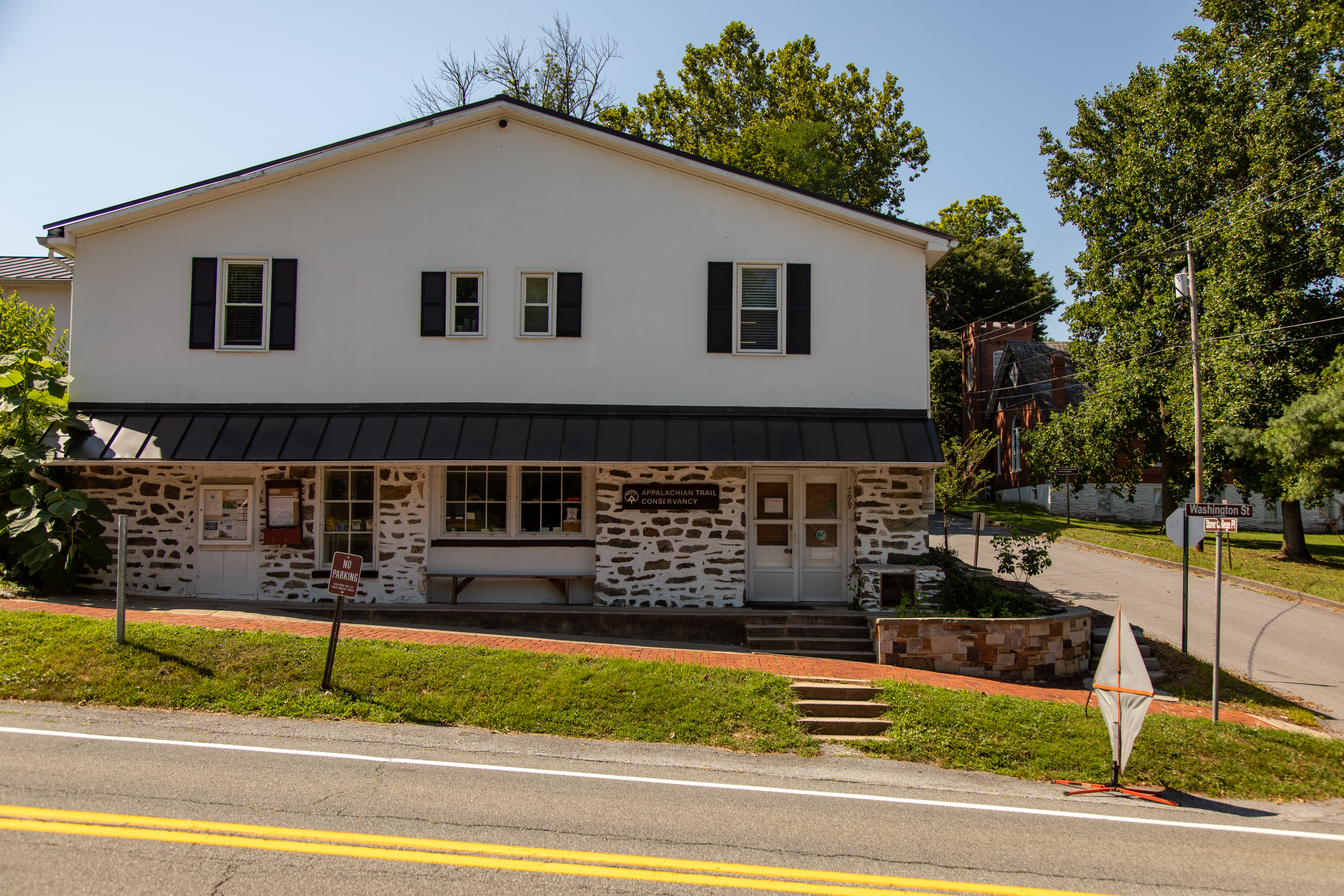
Appalachian Trail Conservancy Building. The ATC visitor center faces Washington Street on the corner of Jackson Street, also known as Storer College Place. It is a two-story white plaster and stone building with a black tin roof protruding above the first floor and spanning the width of the building. The roof overhangs a concrete walkway along the base of the building that is raised to maintain the level of the first floor, counter to the incline of the brick sidewalk out front. The entrance is located through a double door at the right of the building, up four stairs to the stoop. In the center of the front facing wall is inset a double window with a wooden bench underneath. An at the left of the building is a bulletin board and a registration box. On the wall to the left of the front door is a dark wood sign engraved with the Appalachian Trail logo and the words "Appalachian Trail Conservancy." On the right of the door, a square plaque is mounted just above ground level. The plaque reads: The American Institute of Certified Planners has designated The Appalachian Trail as a National Planning Landmark and Benton MacKaye as a National Planning Pioneer. Conceived by Benton MacKaye in 1921 as a walking trail from New England to Georgia, the Appalachian Trail was a pioneering invention in regional interconnection. MacKay's work in regional planning theory and practice also laid the foundations for the Tennessee Valley Authority, the Rural Resettlement Administration programs of the 1930s, and the Civilian Conservation Corps. The National Trails System Act of 1968 made the Appalachian Trail the spinal cord of a fourteen-state greenway and the premier component of a national system of scenic and historic trails. Erected 2000. The American Institute of Certified Planners, The Society for American City and Regional Planning History, The West Virginia Planning Association.
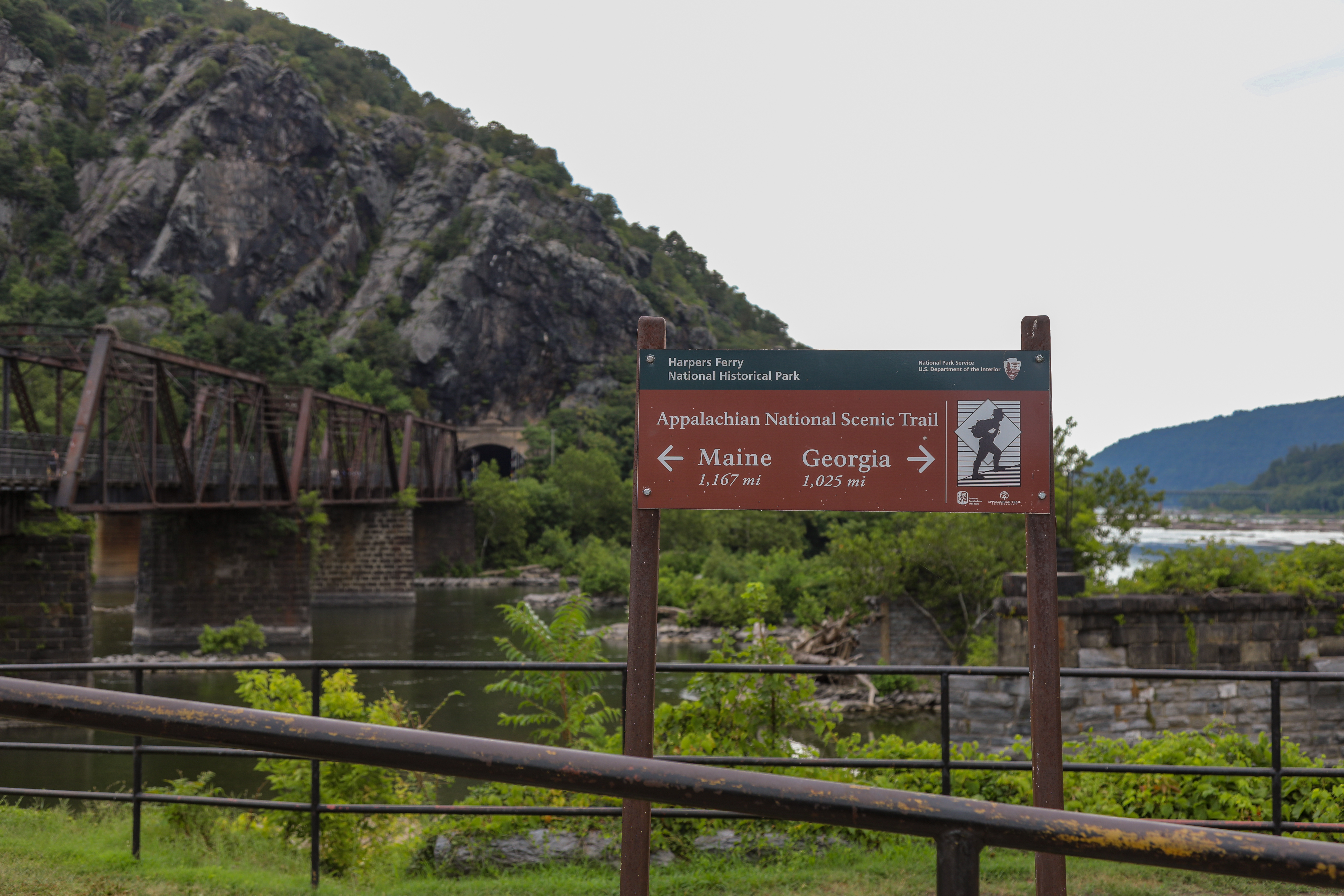
One of the most well-known hikes in the United States, this trail runs through Harpers Ferry and visitors can hike a portion of it! This sign at The Point can help direct guests and get them started on this famous trail.
Brown sign giving arrow directions toward Maine and Georgia for the Appalachian National Scenic Trail. In the background, a railroad bridge over a muddy river leading to a rocky cliff face dotted sparsely with trees.
The United States Armory was the main reason Meriwether Lewis came to Harpers Ferry. Lewis needed dependable weapons and supplies from the armory to succeed on his mission. The quality of the armorers' handiwork would also mean the difference between life and death for Lewis and his men. In 1803, the armory consisted of ten buildings just upstream and underneath the existing railroad embankment.
Grassy plot of land that stretches beside the banks of the Potomac River. Although there is no visible sign of the Armory buildings that once occupied this site, interpretive wayside signs provide information about the buildings, the workers that labored in them, and some of the artifacts that have been recovered during archeological surveys.
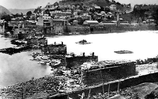
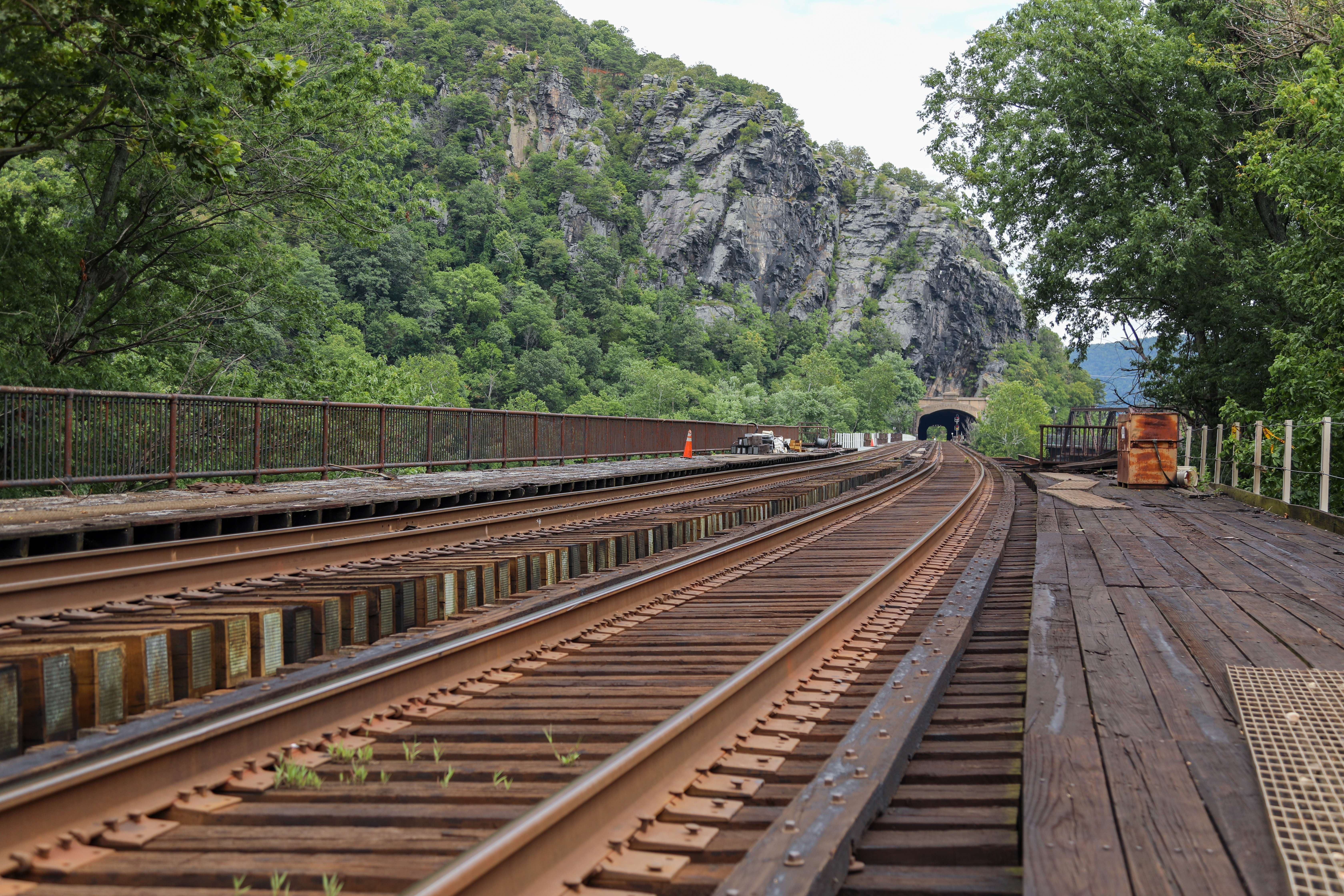
The Baltimore & Ohio (B & O) railroad bridge was once a majestic wood covered bridge that spanned the Potomac River and carried train traffic on the B & O Railroad for 23 years prior to the outbreak of the Civil War.
*Please be cautious near the railways as they are still in use. Cross only where permitted. <br /><br />The Baltimore and Ohio Railroad revolutionized the way people traveled in the 1800s. A historical railroad, the B&O was responsible for transportation of materials throughout the Midwest. The tracks are still in operation today and visitors can visit this station. Experience the oldest common-carrier railroad in the nation!
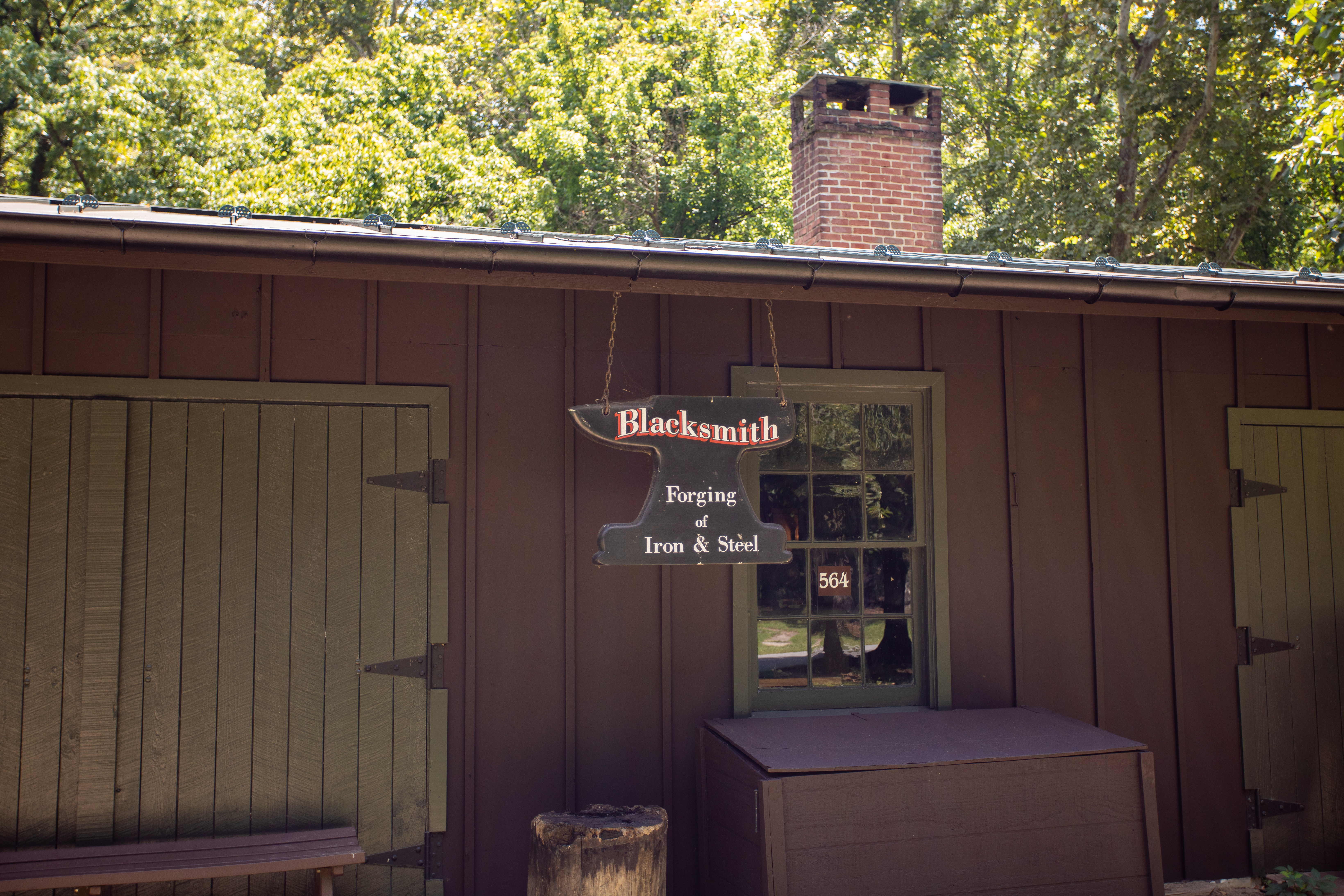
The Blacksmith Shop is open during some special events, living history weekends, and historic trades workshops. Check the park's calendar for instances of the building being staffed.
Blacksmith Shop. This single-story building is sided with dark brown painted vertical wood panels. A brick chimney rises from atop the nearly flat dark tin roof. Along the front of the building, facing Shenandoah Street, there are two sets of extra wide double wide wooden doors with a window between them and another window at the far right. The doors and window frames are painted dark green. Underneath each window are dark brown wooden boxes with hinged lids and each doorway has a brick landing in front, flush with the ground. Hanging from the eave to the right of the left-hand doorway is an anvil-shaped sign that reads: Blacksmith. Forging of Iron & Steel. During certain hours, the doorways may be open for demonstrations.
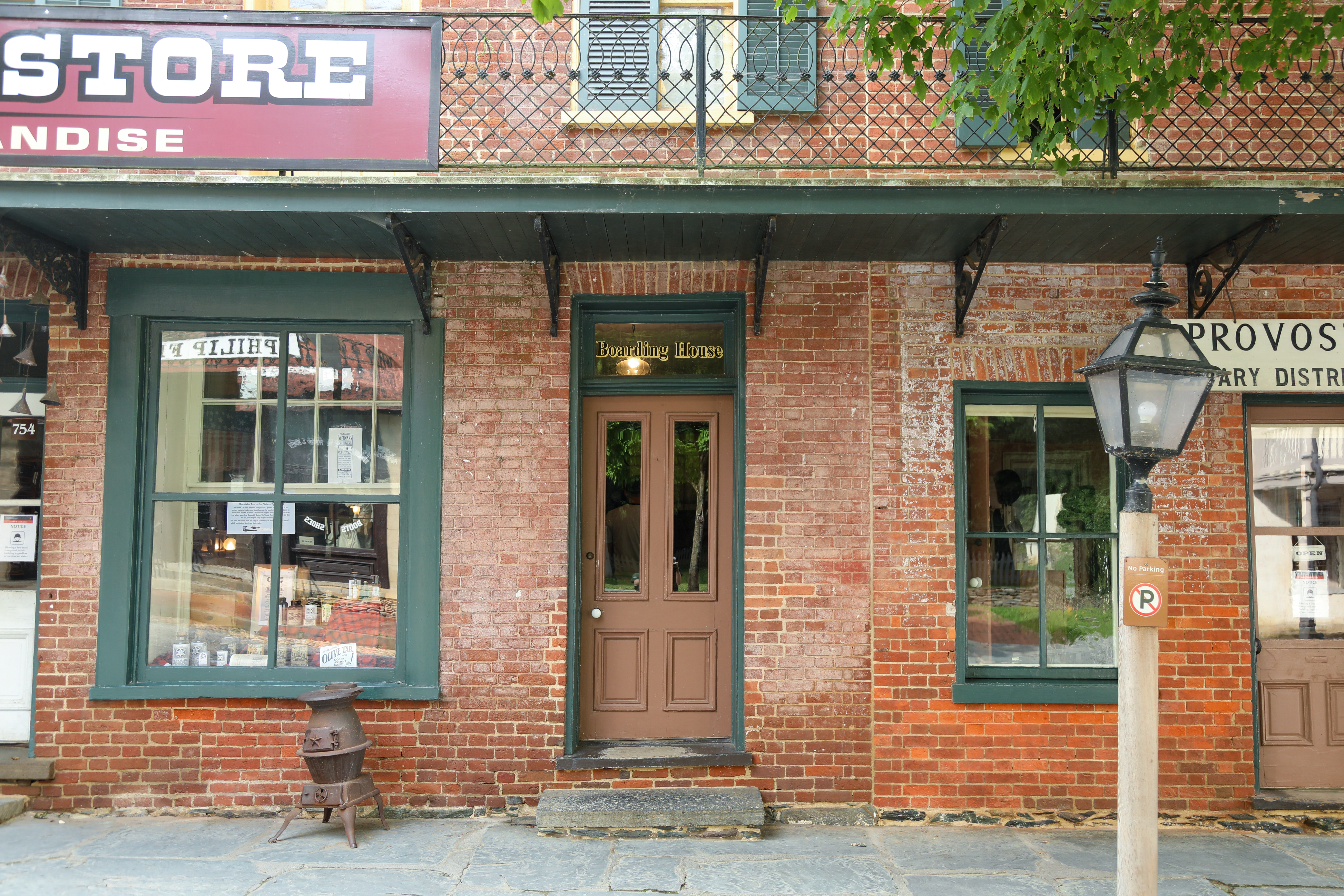
Located on the second floor of the Provost Marshal Building, this floor showcases what living quarters would look like for different people during the Civil War period. James Taylor, a newspaper sketch artist, resided here in 1864 alongside Mrs. Stipes and her daughters who ran the housing. Get a sense of what living here was like during the 1860s by exploring these replica rooms!
Boarding House, exterior and interior hallway. Nestled between the Provost Marshal on the right and the Dry Goods Store on the left is the Boarding House. A sign underneath the 3rd floor window reads "Stipes Boarding House. Daily and weekly rates." Up one stone step and over the wooden threshold, a single brown door provides access to the inside during park operating hours. The door frame is painted dark green and a window above the doorway is painted with the words "Boarding House." A wayside inside the hallway, just to the left of the base of the stairs, features a drawing of Shenandoah Street in 1864 by sketch artist James E. Taylor (courtesy of the Western Reserve Historical Society, Cleveland, Ohio). The Harpers Ferry Military District Headquarters building is at center and, just to the right, is Mrs. Stipes' Boarding House. The Boarding House is depicted as a two-floor building with a portico in front. The panel reads:<br />Keeping the Wolf from the Door. Cornelia Stipes, a Harpers Ferry widow, and her three daughters ran a boarding house in this building during the Civil War. This money kept her family from starving. In the words of her boarder, Civil War sketch artist, James Taylor, "Mrs. Stipes catered to sojourners at the Ferry... to keep the wolf from the door." A doorway just to the right as you enter the Boarding House provides another glimpse into the Provost Marshal's office, from the left side of the room. A locked wooden gate prevents access but we can see a yellow wooden bench placed underneath a window along the far wall and, nearer to us, we see a desk with its various cubbies stuffed with papers and bound ledgers filed on shelves. Continue up the stairs at the back of the entry hall to the second and third floors to see rooms furnished as they would have been while this was an active Boarding House.
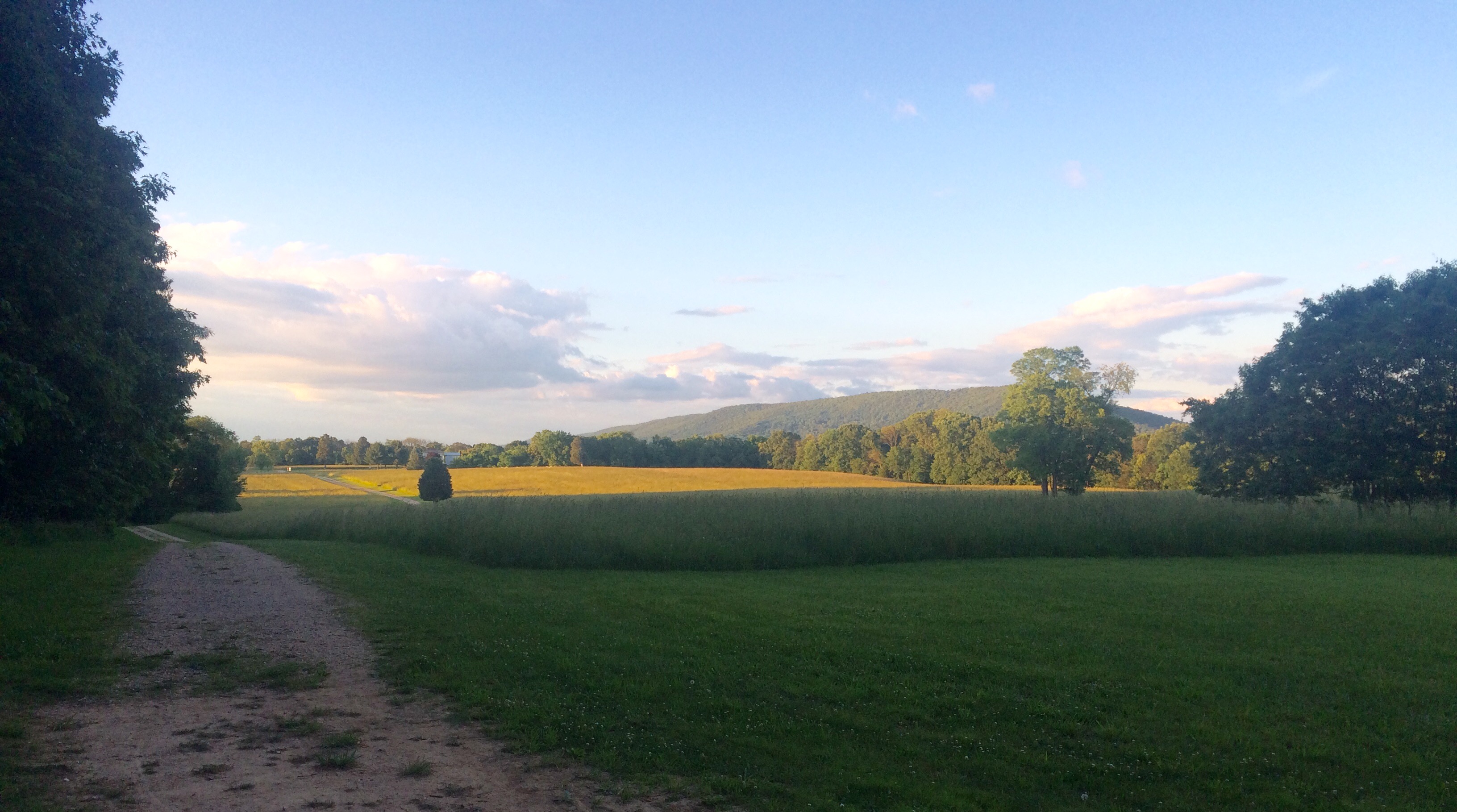
Bolivar Heights is one of the most important Civil War battlefields in West Virginia -- it was the site of the largest surrender of United States troops during the Civil War. Today, from this location, you can walk beside trenches, take a hike in the woods, or enjoy an incredible vista where you can see most of the park areas from one vantage point. You can drive to this location on your own.
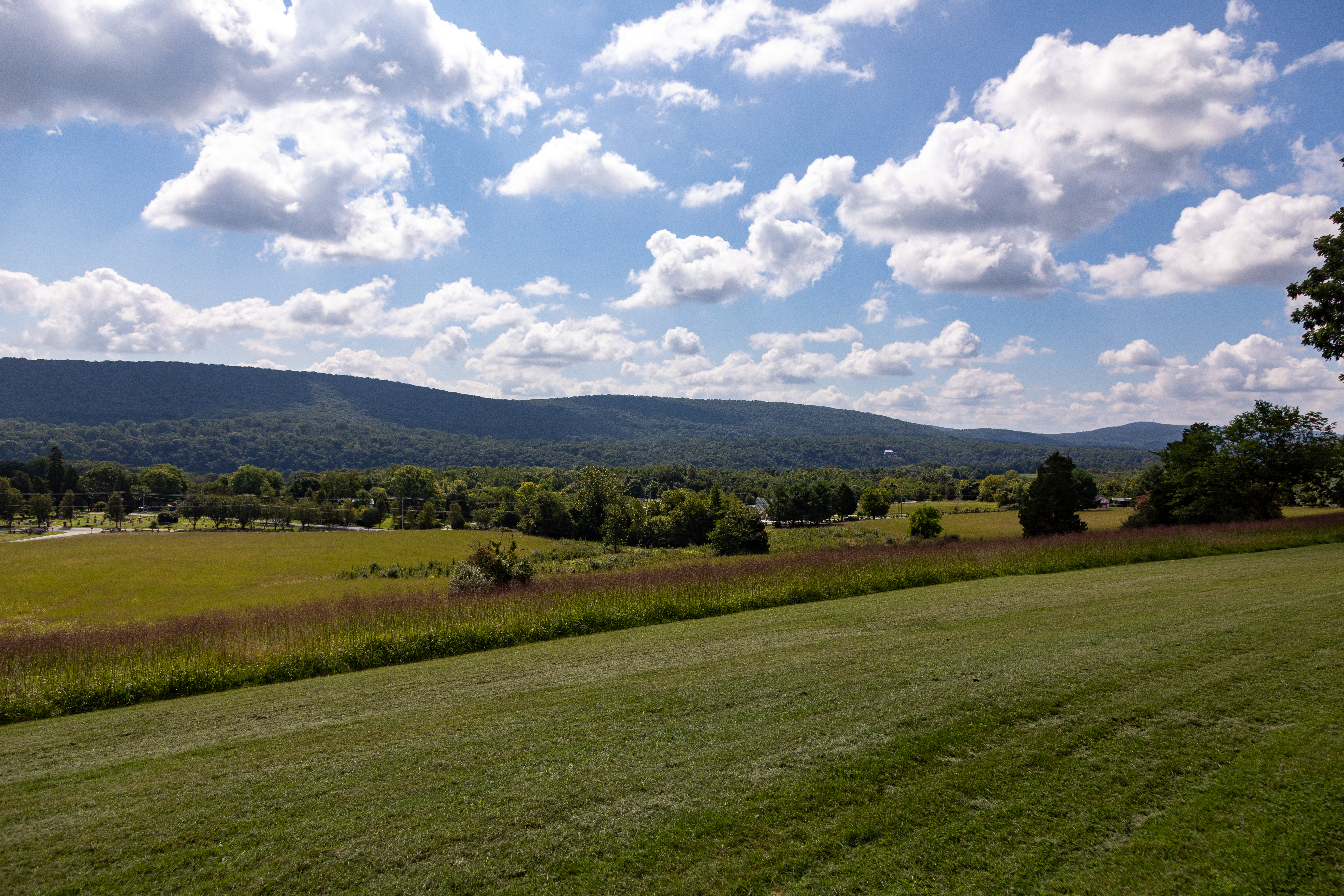
Some of the best views of the Blue Ridge Mountains, Potomac River water gap, and the Shenandoah Valley. Green, rolling hills dotted with trees, surrounded by wooded mountains, with a river in the distance.
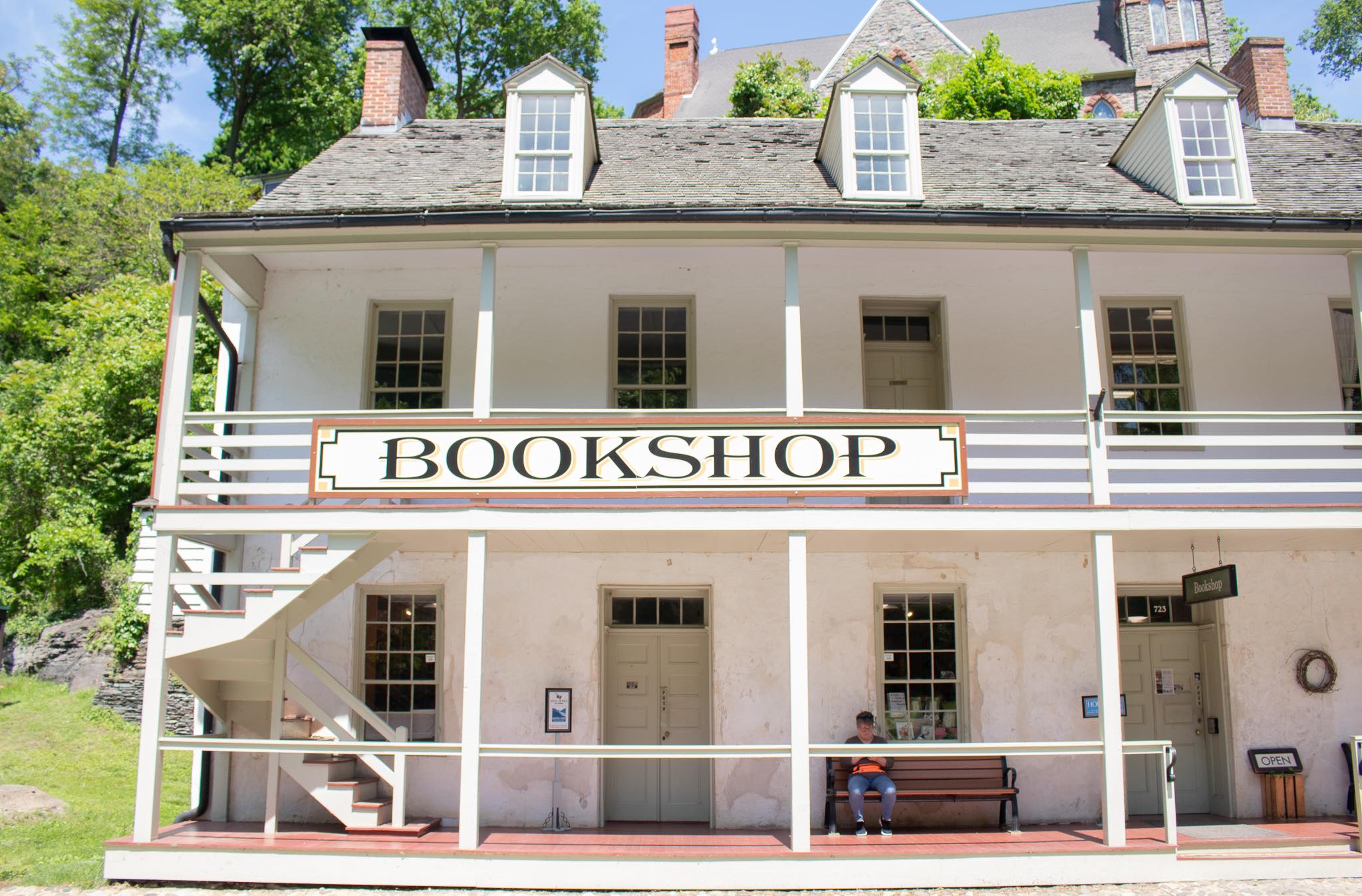
Visitors can browse our selection of official Harpers Ferry merchandise at the Bookshop in historic Lower Town. Any guests with a National Park Passport booklet can get their passport stamps here as well. The Bookshop is the perfect opportunity to take a piece of Harpers Ferry home.
The bookshop is located inside a two-story white plaster building with four dormer windows protruding from the roof facing Shenandoah Street and a brick chimney at the top left. The front of the building features a two-story porch that spans the width of the building with a staircase to the second floor located on the left. On the second floor are four windows and two doors. Hanging from the second-floor porch railing are two signs: one on the left says "Bookshop" and one on the right says "Fancy Goods." On the first floor are three doors interspersed among three windows. The porch, doors, and window frames are painted pale green. The bottom floor porch is open to access the main entrance just to the right of center and again in front of the door at the far right. There are two steps up to the porch from the road and wheelchair access is available from the right side of the porch. Benches are located on either side of the main entrance and a sign standing to the left of the door lists the operating hours. Another sign at the foot of the stairs leading to the second floor tells us the main office of the non-profit Harpers Ferry Park Association is located up stairs.
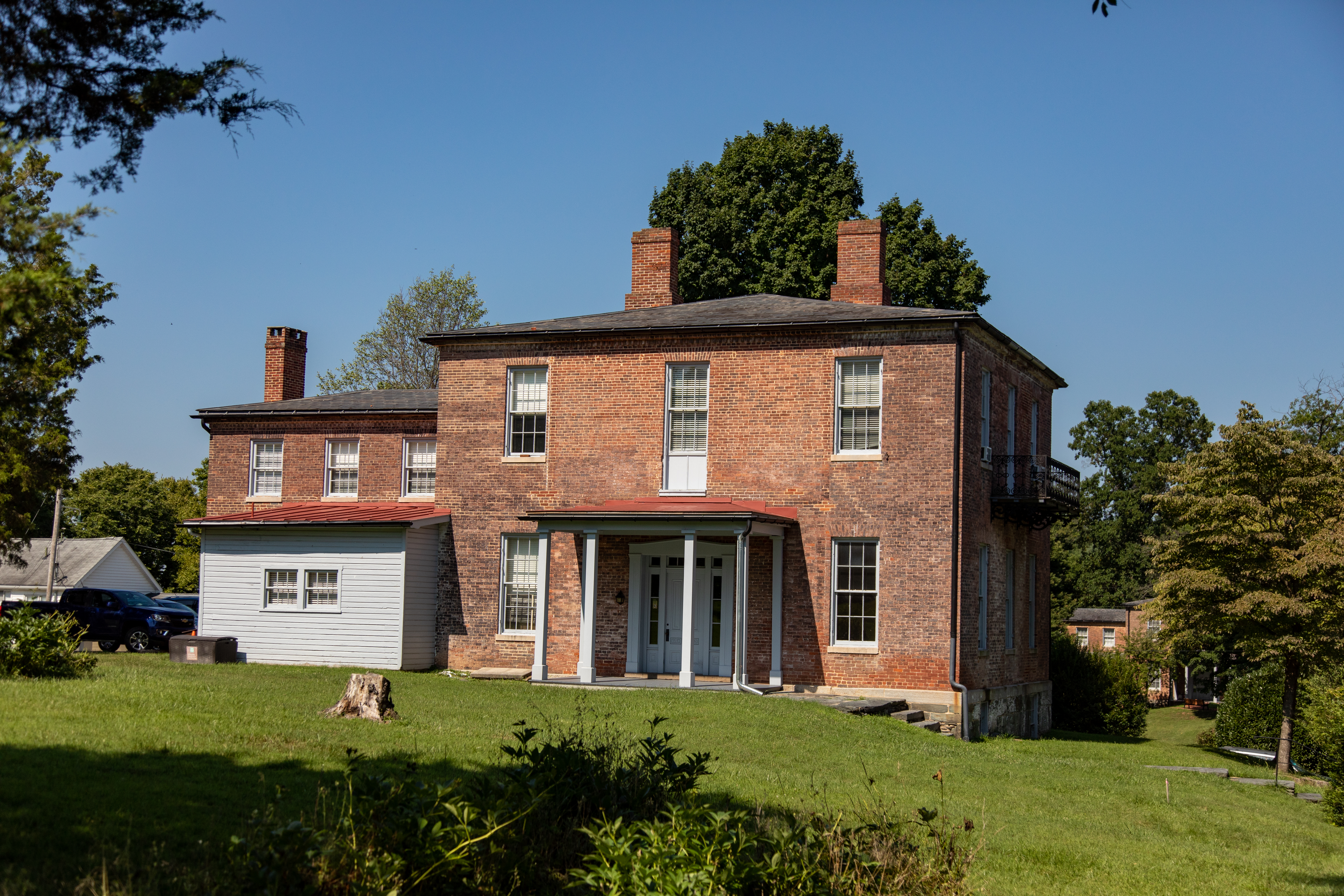
Built in 1858, this house served as the home for the U.S. Armory superintendent's clerk. As an assistant to the superintendent, the clerk's responsibilities included drafting correspondence, filing reports, arranging schedules, and insuring the smooth operation of the superintendent's office.After Storer College was established for freedmen in 1867, the building was named in honor of Dr. Nathan Brackett - educator, minister, administrator, and financier - who helped found the
Sixteen irregular and uneven stone steps, with handrails on the left, lead up from Fillmore Street to the front entrance of the Brackett House. This two-story weathered brick building stands on a stone foundation and features two chimneys protruding from the center of the low-pitched roof and a portico covering the entrance, facing to the left. The windows, doors, and columns are painted a bluish-grey. On the right-side wall, facing Fillmore Street, an ornamental black iron balcony extends from the wall underneath the center window on the second floor. At the left side of the building, set back a bit from the front wall is a smaller two-story wing with a small closed-in room sided in blue-grey painted wood panels. To the left, across the lawn in front of the Brackett House is the Lockwood House. Six steps up from the road, there is a landing with a lamp post at right and a 2 foot by 1 foot panel at the left, past a break in the hand rail. The panel is mounted just to the right of a low stone wall so be mindful of your step. The panel features a historic photo of the Brackett House in 1908, during its Storer College tenancy. Text tells us: Built in 1858, this house served as the home for the U.S. Armory superintendent's clerk. As an assistant to the superintendent, the clerk's responsibilities including drafting correspondence, filing reports, arranging schedules, and insuring the smooth operation of the superintendent's office. After Storer College was established for freedom in 1867, the building was named for in honor of Dr. Nathan Bracket - educator, minister, administrator, and financier - who helped found the college and served as its first principal. Brackett arranged to have his this and three other "fine old mansions" in the upper town, dilapidated and abandoned after the Civil War, turned over to the college by the government. The Brackett House currently is not open.
Camp Hill is an area of the park that encompasses armory, Civil War, and civil rights stories. Visitors can drive there directly or hike to the area from Lower Town along the Appalachian Trail. If taking the hike, stop by <a href="https://www.nps.gov/hafe/learn/historyculture/jefferson-rock.htm">Jefferson Rock</a> to take in the scenery before exploring the former <a href="https://www.nps.gov/hafe/learn/historyculture/storer-college.htm">Storer College</a> campus or visiting the <a href="http://www.appalachiantrail.org/">Appalachian Trail Conservancy</a> .
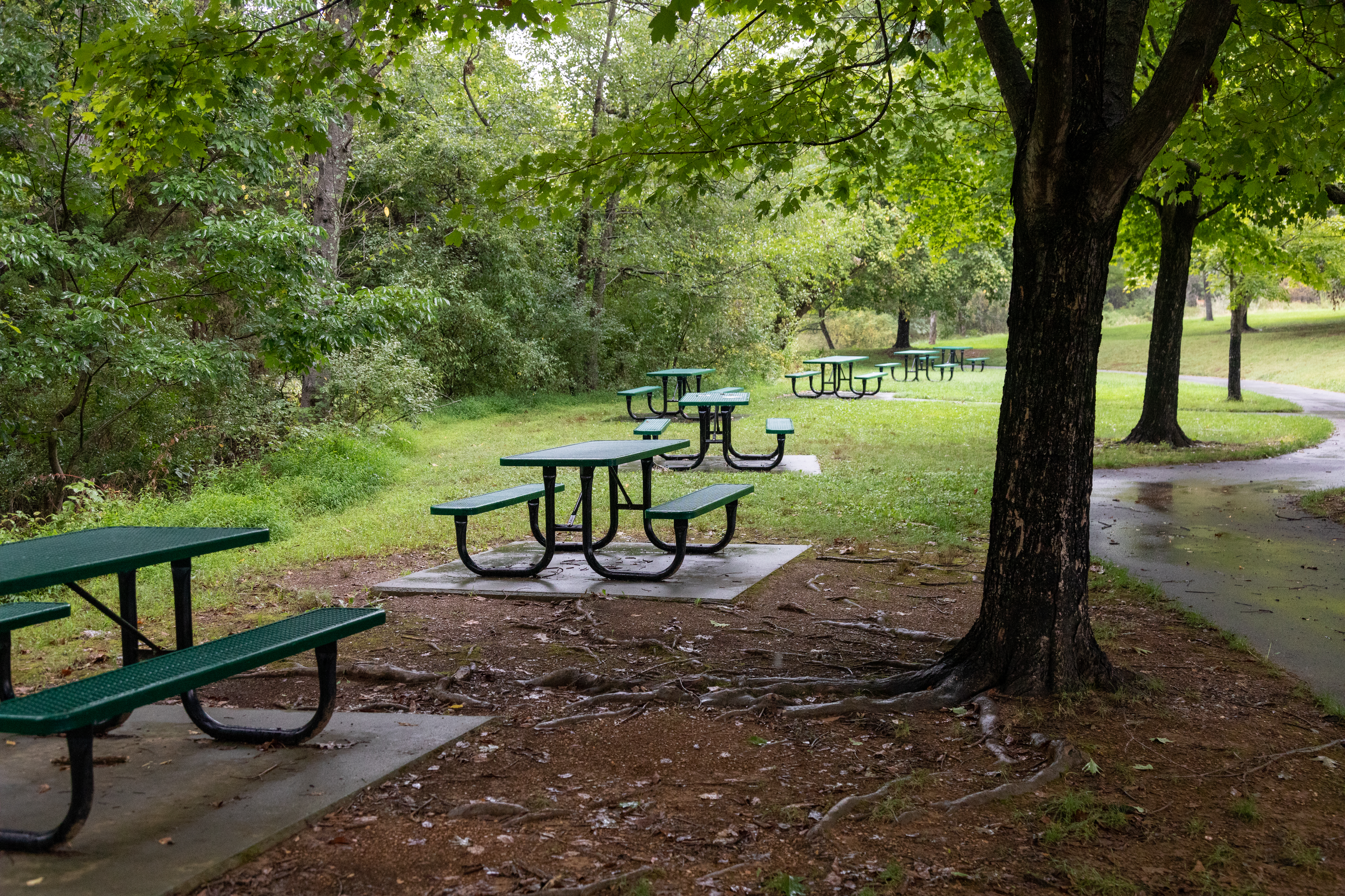
Picnicking is available at Harpers Ferry National Historical Park at a designated picnic area adjacent to the Visitor Center parking lot. Its location by the parking lot provides ample parking for vehicles and buses. The picnic area includes 14 tables in a mostly shaded area. Restroom facilities are available at the Visitor Center plaza.
The park's Civil War Museum is indefinitely closed due to water damage. We are working on creating a virtual exhibit for the park website that contains the same information as the museum.
Civil War Museum, exterior. *This exhibit temporarily closed due to water damage* This red brick building houses the Civil War museum exhibits. The front of the building has two sets of wood and glass double doors interspersed between three large, 4 foot by 7 ½ foot windows. The wooden exterior is painted dark green and the doors and window frames are trimmed in white. The large windows frame greyscale pictures on a white background, preventing viewing of the space inside. The window at the far left has a drawing of two flags of the Confederacy with 3 wide horizontal stripes and a circle of 11 stars in the upper corner field. The center window has an image of two simple tents, their flaps closed. A stand of three muskets in the foreground. The window at the right has a drawing of a snare drum with a bald eagle insignia on the side. Behind the drum, an early American flag is crossed with a bayoneted musket. Access to the exhibits can be gained from either set of doors. The doorway at left has two steps up to navigate and the handle is on the left-side door. The doorway at right has a slightly raised threshold and the handle is on the right-side door.
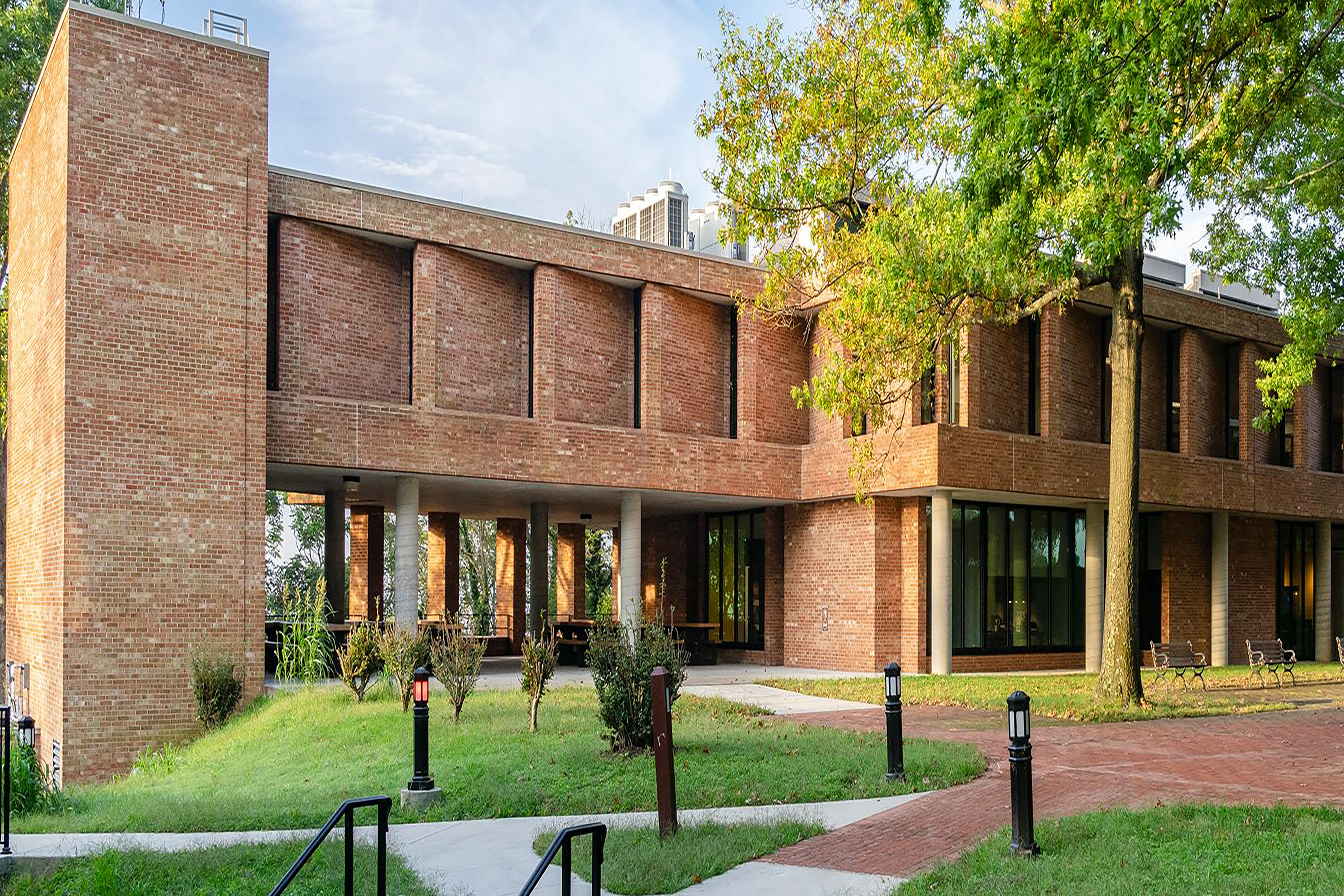
Permelia Eastman Cook Hall was built by Storer College in 1940 to house the physics laboratory and the home economics department. This building now serves as office space for multiple National Park Service entities including the Appalachian National Scenic Trail.
The Corps of Discovery Museum features the Corps of Discovery coins that represent the established section of the army of the same name. This Corps was one of the big contributing factors to the Lewis and Clark expeditions.
This 1894 church once contained a kitchen, classroom, library, vestry room, and auditorium. Niagara Movement members worshipped here during their historic meeting in Harpers Ferry.
Located along Jackson Street, the Curtis Freewill Baptist Church is a relatively modest red brick structure with a pitched roof built on a white painted stone foundation. A two-story square campanile extends from the right-side corner and is capped by a parapet. White painted slatted vents are on the sides near the top of the tower and, underneath those, mid-way up the tower, are diamond shaped windows. And the main entrance is at the base of the tower on the side perpendicular to Jackson Street, facing Fillmore Street. A metal wheelchair ramp lined with handrails on either side has been installed over the original stone stoop. The double door is painted white with a half-round window above. Just over the arched window is a red stone carved with the words: Curtis Freewill Baptist Church, 1894. Along the wall to the left of the tower are 4 rectangular windows inset with colorful stained-glass squares and names written along the top. The names face the inside so they appear backwards to the outside viewer. Two doors are set into the basement level along this side and uneven stone stairs lead down from the brick walkway. A parking lot is to the left of the church. Along the side facing Jackson Street, underneath the diamond window in the tower is a half-circle window. To the right of the tower are three arch-top windows inset with colorful stained-glass squares and names written along the top. The center window is double the width of the other two windows and is 5 feet tall. It is inset with two crosses and the word "Morrell" is visible at the top. To the right of the front stoop is a two-foot tall square brick base with a pentagon-shaped plaque mounted on top. The words on the plaque read: IN MEMORY OF THE BLACK AMERICANS Who Fought Here For Freedom From Human Slavery. June, 1976. Erected by the Association for Study of Afro-American Life and History in cooperation with the AMOCO Foundation, Inc. The grounds, stairs, and pathways around the church are uneven and may have raised borders. There are also trees, lamp posts, and telephone poles about so be mindful while navigating around the property.
Step through the doors of this exhibit and be taken back in time to an 1860s store where you could buy anything from cloth and hats to spices and household items. When the exhibit is staffed, take the time to learn about the time period by chatting with the person in the store.
The building is a red brick three story building with a second story balcony that has a sign reading “Dry Goods Store – General Merchandise” on it in white and yellow lettering on a red background. The store front has two windows on either side of a white door. Above the door is another sign reading “Dry Goods Store – General Merchandise” in white lettering on a green background. In front of the window to the left is a green trough and a blue A-frame sign that reads “Dry Goods Store Open.” In front of the right window is a small rusty stove and a wooden crate turned up on its side. Inside the right-side window are holiday decorations and toys. The windowsill is covered with a red and black checkered cloth. On the left side, a wooden sled is leaning against the side wall of the windowsill. Wooden toys and red mittens sit in front of it. On the right side, the outline of a Christmas tree made of a few branches and ornaments sits raised on a box. In front are black and white figurines of a horse and pig.
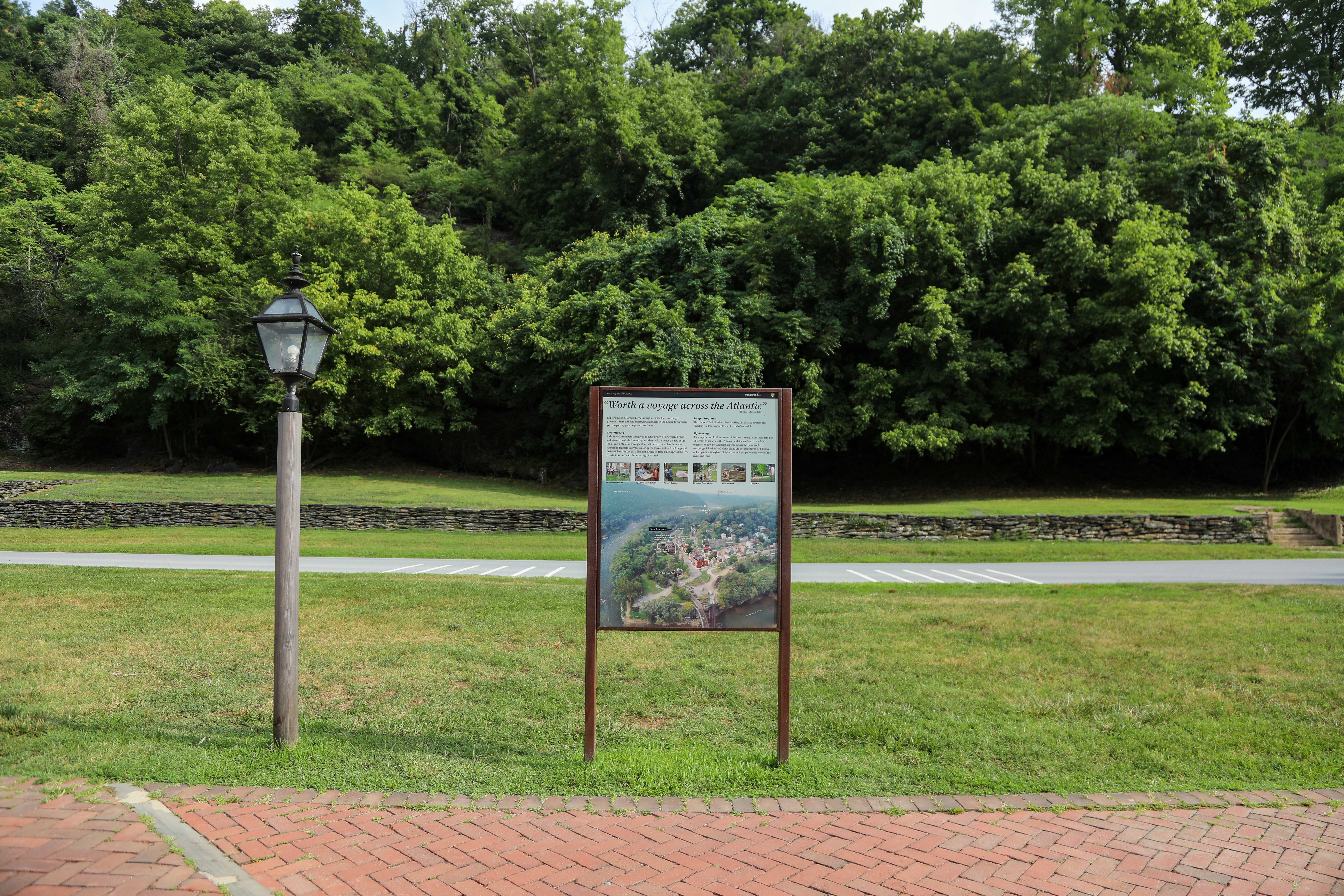
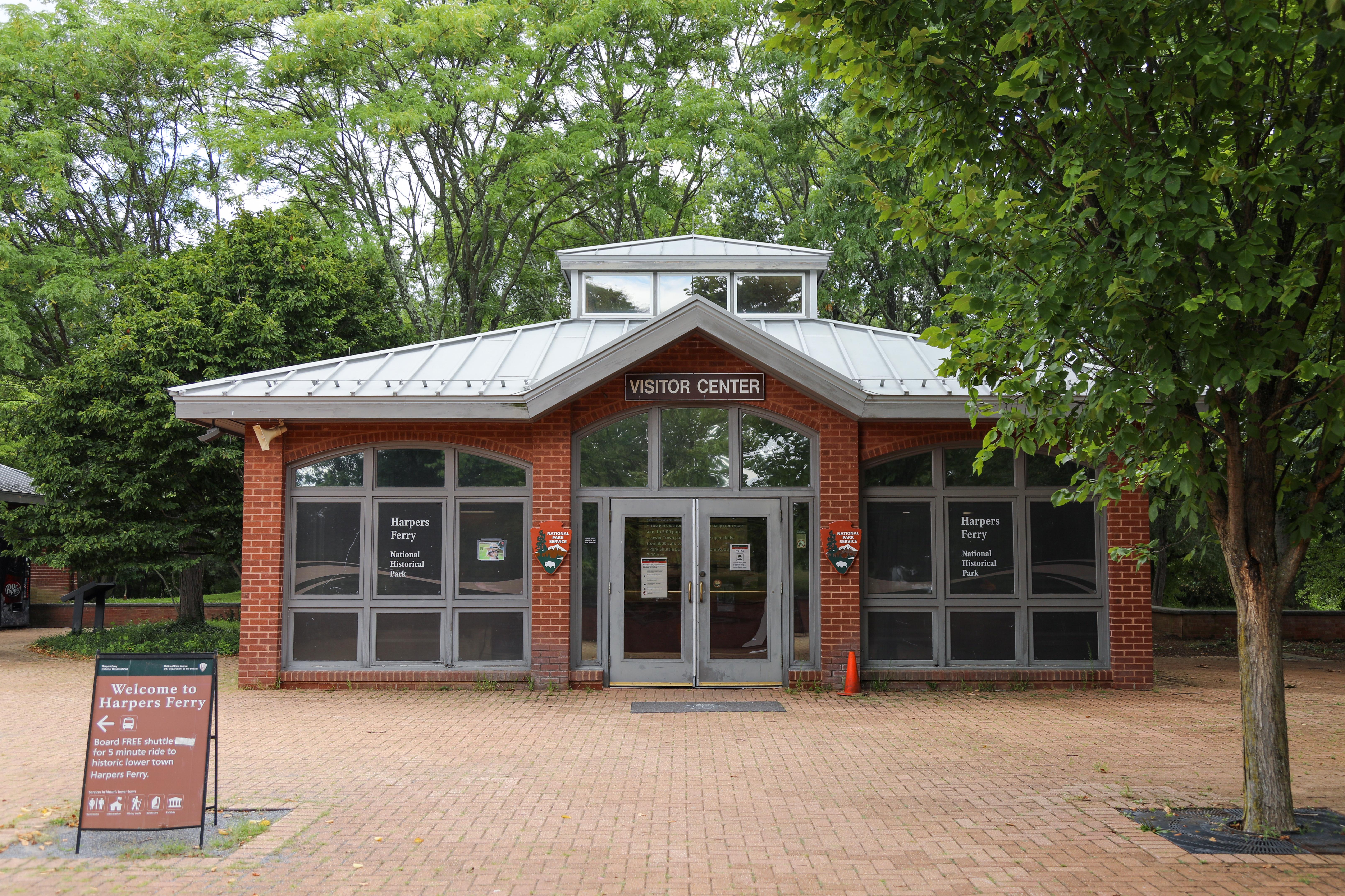
Start your visit to Harpers Ferry NHP here, where you can purchase your park entrance pass and proceed to park adjacent to the Visitor Center and park shuttle bus stop.
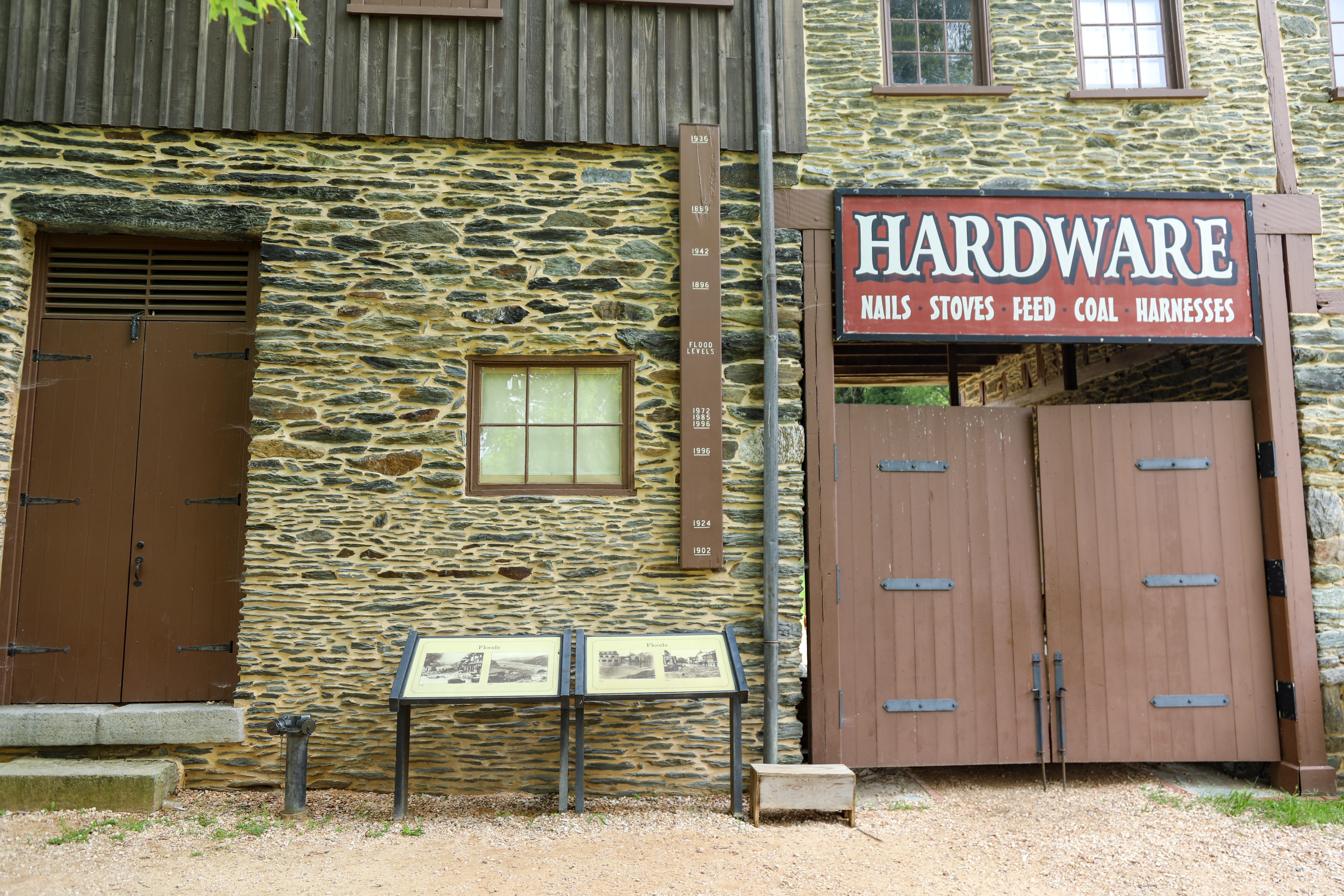
A skinny, brown, rectangular piece of wood mounted to a stone building, oriented vertically. In the middle of the marker, in white paint, is the label "Flood Levels." In descending order from the top, in white paint, are numerical indications of years with corresponding horizontal lines: 1936, 1889, 1942, 1896, 1972, 1985, 1996, 1996, 1924, 1902. The marker is mounted on a building composed of rock on the bottom and wood on the top. Three waysides in front of the marker show black and white photos of flood damage in 1889, 1936, 1924, and 1972.
The oldest building in Harpers Ferry, this house began construction in 1775 by Robert Harper, the town's namesake. The house was finished in 1782; however, due to his passing, Harper never lived in it. The Harper House stands today as a relic of Harpers Ferry during the American Revolution.
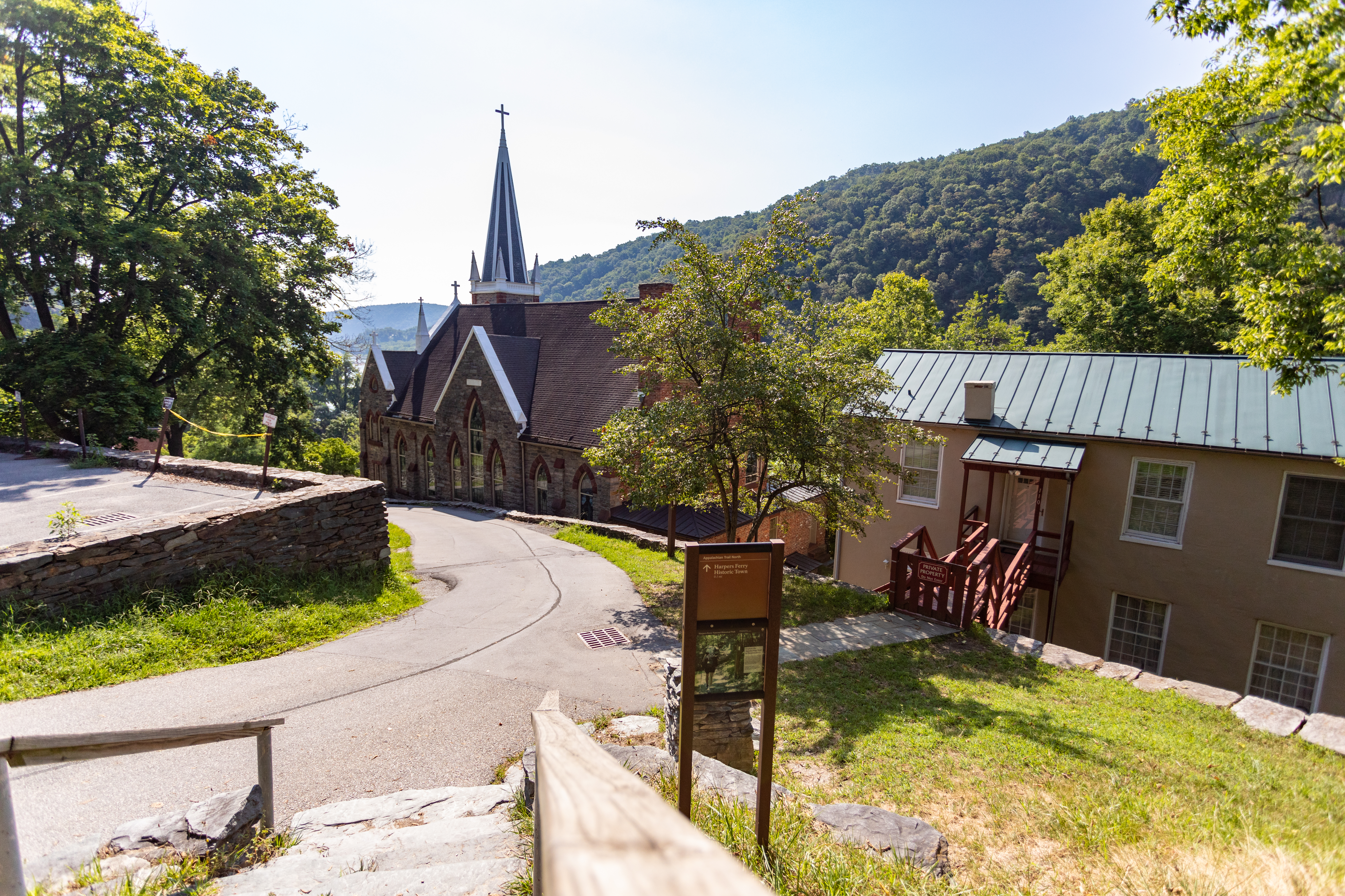
Double-paneled rectangular sign on double posts beside stone steps, leading into Lower Town Harpers Ferry. The top panel, brown background with white lettering, reads "Applalachian Trail North, Harpers Ferry Historic Town 0.1 mi." A white arrow points straight ahead. The bottom panel depicts an image of a hiker carrying a large pack and using two hiking poles on a dirt path through the woods. She is passing a brown trail marker with a white rectangular blaze. A text box reads, "Explore the Appalachian Trail in Harpers Ferry. You are standing on the 2,176 mile Appalachian National Scenic Trail (A.T.). Every year hundreds of A.T. hikers travel through Harpers Ferry on their trek to Maine or Georgia. Join them by following the white blazes that mark the trail. Look for white blazes--2" x 6" rectangles--painted on posts and trees throughout the park."
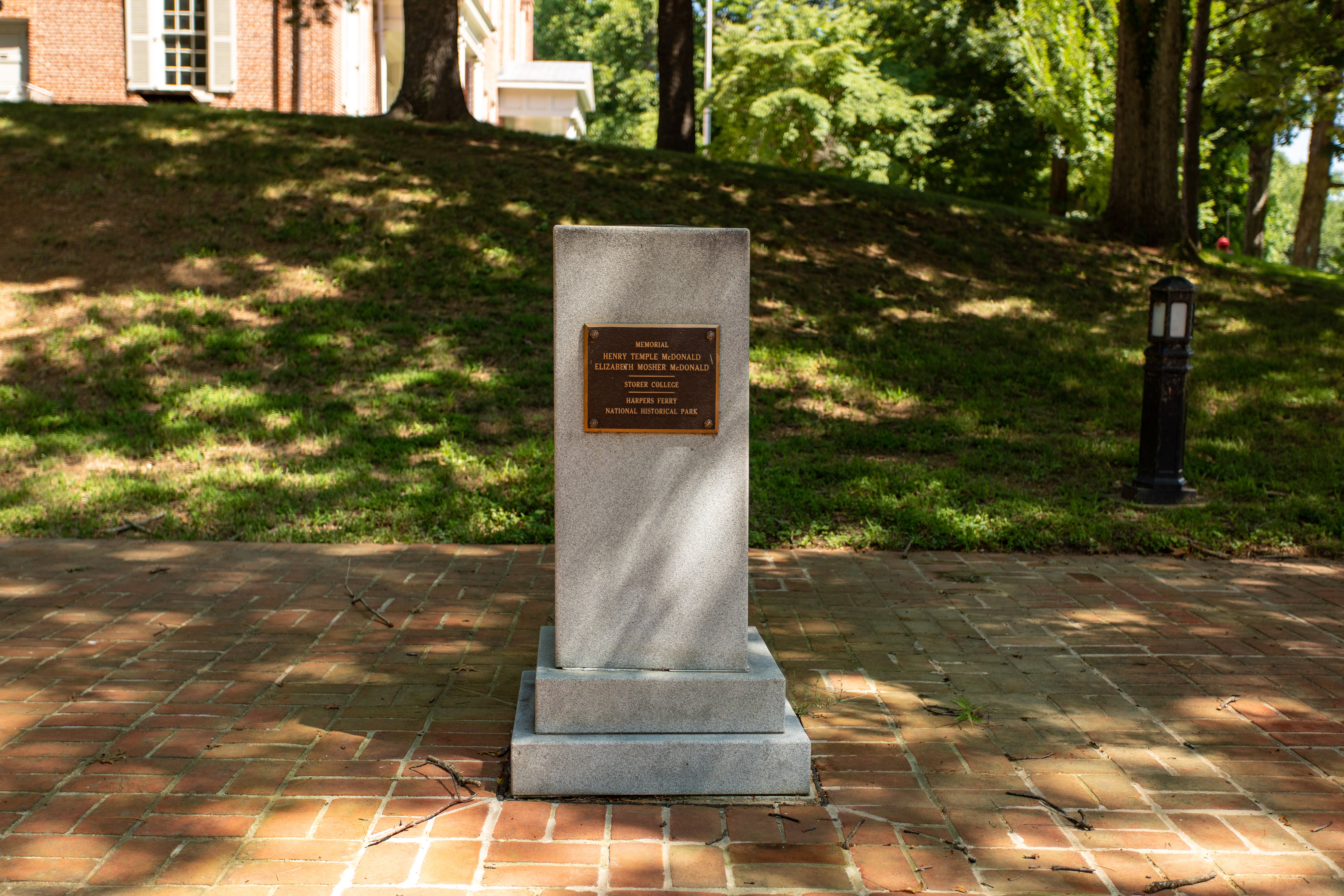
Granite upright rectangular monument, oriented vertically. A bronze plaque on the front reads, "Memorial, Henry Temple McDonald, Elizabeth Mosher McDonald, Storer College, Harpers Ferry National Historical Park." A circular bronze sundial on the top of the monument has an inscription that reads, "To forget how to dig the earth and to tend the soil is to forget ourselves."
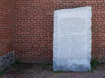
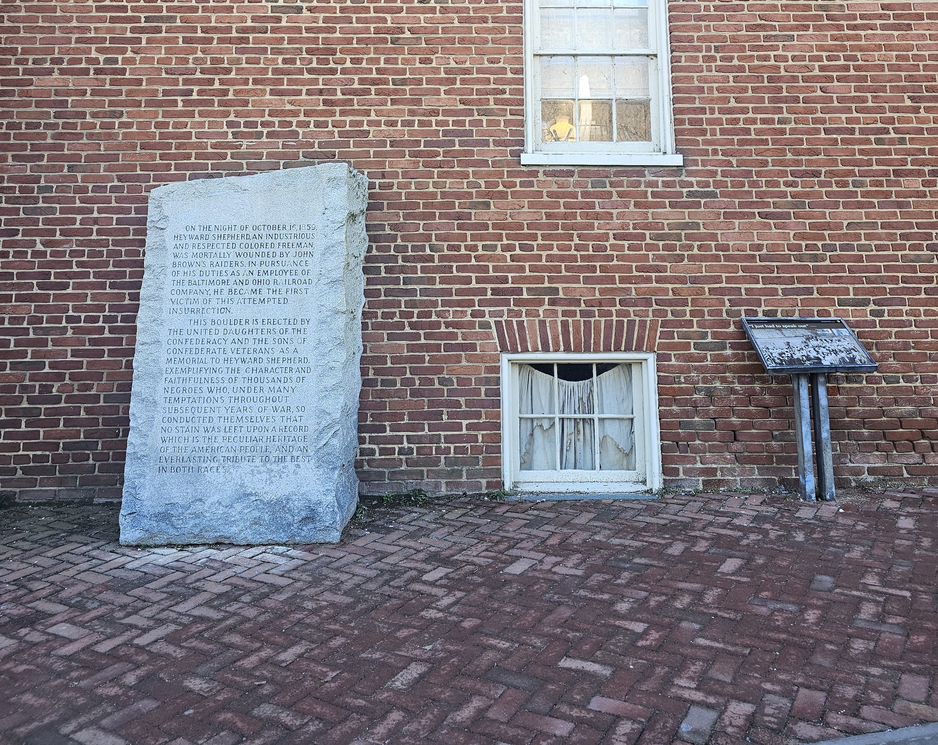
Large rectangular bleached stone memorial, oriented vertically, that sits on the brick sidewalk near the terminus of Potomac Street and Shenandoah Street. A brick building sits behind it. The marker reads, "On the night of October 16, 1859, Heyward Shepherd, an industrious and respected colored freeman, was mortally wounded by John Brown's raiders. In pursuance of his duties as an employee of the Baltimore and Ohio Railroad Company, he became the first victim of this attempted insurrection. This boulder is erected by the United Daughters of the Confederacy and the Sons of Confederate Veterans as a memorial to Heyward Shepherd, exemplifying the character and faithfulness of thousands of Negroes, who, under many temptations throughout subsequent years of war, so conducted themselves that no stain was left upon a record which is the peculiar heritage of the American people, and an everlasting tribute to both races."
Learn about popular industries of Harpers Ferry in 19th century! The Industry Museum showcases the factories of Virginius Island, explains how weapons were made by machine, and much more. <br /><br />Please note: the accessible entrance is on the right side of the building, follow the brick pathway toward the back of the building.
Industry museum is housed in a three-story rectangular white building with balconies on the 2nd and 3rd floors. A green rectangular sign with white lettering reading "Industry Museum" hangs above the entrance to the museum. Inside, on the right, nineteenth century industrial machinery for making weaponry is displayed behind wooden railing, including milling machines, spindle drill presses, rifling machines, and barrel-turning lathes. Panels describe the machinery: "Lock, Stock, and Barrel: The federal armories at Harpers erry and Springfield, Massachusetts, were among the first machine operated industries in the United States. Workers in the armories used many labor saving machines to produce the three major components of the musket: the lock, the stock, and the barrel. This exhibit shows representative examples of machines used in the 1850s. All were driven by water power, transmitted to the machine through pulleys and leather belts." "Stock: The wooden stock of the musket was the first component manufactured by mass production machines. The duplicating lathe, sometimes called a Blanchard lathe for its inventor, quickly turned out walnut stocks identical to the pattern." "Barrel: The barrel of a musket required exacting production techniques. The bore had to be a uniform diameter, and the metal free from flaws. A special type of machine called a barrel-turning lathe smoothed the exterior of the barrel and cut the correct taper from breech to muzzle." "Rifling Machine: With the advent of rifled muskets, twisting grooves were cut inside the barrel with a rifling machine. A bullet fired from a rifled barrel spirals in flight, giving it greater accuracy over long distances." On the opposite wall from the entrance, a display shows an iron stove pipe, two barrels, a small basket, and an iron fence. On the left side of the room, a large illustration labeled "Virginius and Hall's Islands, 1857" depicts a cluster of buildings along the Shenandoah River from a overlook. To the right of the illustration, a panel labeled Transportation depicts the modes of transportation used by Harpers Ferry residents. To the left of the illustration, two cases show Harpers Ferry products, including cloth.
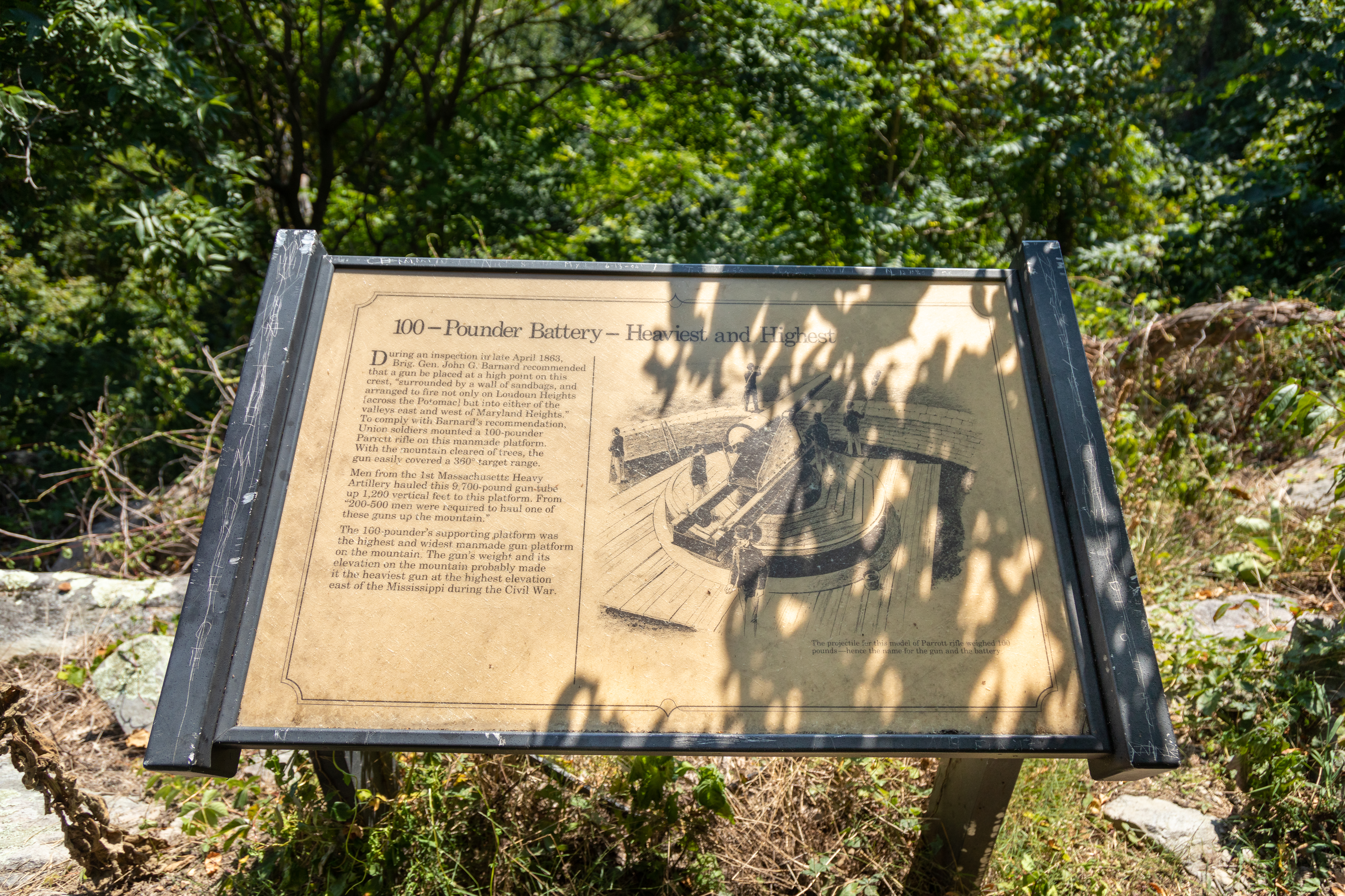
During an inspection in late April 1863, Brig. Gen. John G. Barnard recommended that a gun be placed at a high point on this crest, "surrounded by a wall of sandbags, and arranged to fire not only on Loudoun Heights [across the Potomac] but into either of the valleys east and west of Maryland Heights." To comply with Barnard's recommendation, Union soldiers mounted a 100-pounder Parrott rifle on this manmade platform. With the mountains cleared of trees, the gun easily covered a 360 degree target range. Men from the 1st Massachusetts Heavy Artillery hauled this 9,700-pound gun tube up 1,200 vertical feet to this platform. From "200-500 men were required to haul one of these guns up the mountain." The 100-pounder's supporting platform was the highest and widest manmade gun platform on the mountain. The gun's weight and its elevation on the mountain probably made it the heaviest gun at the highest elevation east of the Mississippi during the Civil War.
Positioned here at the end of a towering plateau, this fortification was the first earthen battery built on the mountain by the Federals in the fall of 182. Facing south, its guns "commanded perfectly the summits of Loudoun Heights as well as Bolivar Heights."A four sided earthwork forms the dominant feature of this battery. Protecting its exterior slope is a dry moat -- the widest, longest, and most uniform moat on the mountain. 30-pounder Parrotts were standard armament
Positioned here at the end of a towering plateau, this fortification was the first earthen battery built on the mountain by the Federals in the fall of 182. Facing south, its guns "commanded perfectly the summits of Loudoun Heights as well as Bolivar Heights."<br /><br />A four sided earthwork forms the dominant feature of this battery. Protecting its exterior slope is a dry moat -- the widest, longest, and most uniform moat on the mountain. 30-pounder Parrotts were standard armament here.<br /><br />30-Pounder Battery Plan<br />George Kaiser's January 1863 illustration of the 30-pounder Battery shows many features of the earthwork.<br />1. You are here<br />2. Rampart<br />3. Magazine<br />4. Dry moat<br />5. Gun Platform<br /><br />A 30-pounder Parrott rifle on siege carriage, typical of a gun mounted here.<br />Bore diameter: 4.2"<br />Length of tube: 136"<br />Weight of tube: 4200 lbs.<br />Weight of projectile: 29 lbs.<br />Range: 2200 yards (1 1/4-mile)
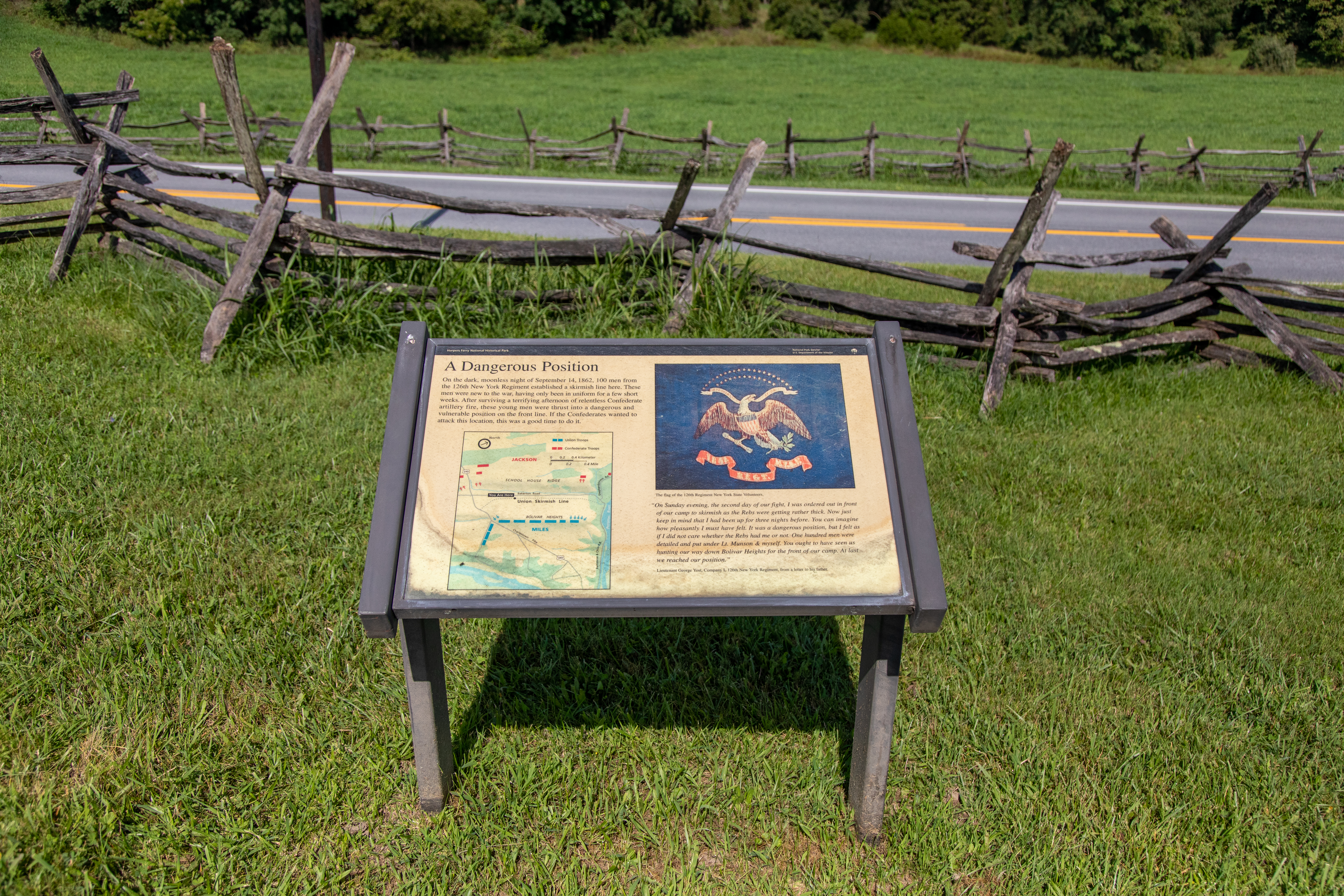
On the dark, moonless night of September 14, 1862, 100 men from the 126th New York Regiment established a skirmish line here. These men were new to the war, having only been in uniform for a few short weeks. After surviving a terrifying afternoon of relentless Confederate artillery fire, these young men were thrust into a dangerous and vulnerable position on the front line. If the Confederates wanted to attack this location, this was a good time to do it.
On the dark, moonless night of September 14, 1862, 100 men from the 126th New York Regiment established a skirmish line here. These men were new to the war, having only been in uniform for a few short weeks. After surviving a terrifying afternoon of relentless Confederate artillery fire, these young men were thrust into a dangerous and vulnerable position on the front line. If the Confederates wanted to attack this location, this was a good time to do it. Quotation: "On Sunday evening, the second day of our fight, I was ordered out in front of our camp to skirmish as the Rebs were getting rather thick. Now just keep in mind that I had been up for three nights before. You can imagine how pleasantly I must have felt. It was a dangerous position, but I felt as if I did not care whether the Rebs had me or not. One hundred men were detailed and put under Lt. Munson & myself. You ought to have seen us hunting our way down Bolivar Heights for the front of our camp. At last we reached our position." Lieutenant George Yost, Company I, 126th New York Regiment, from a letter to his father. Photo caption: The flag of the 126th Regiment New York State Volunteers.
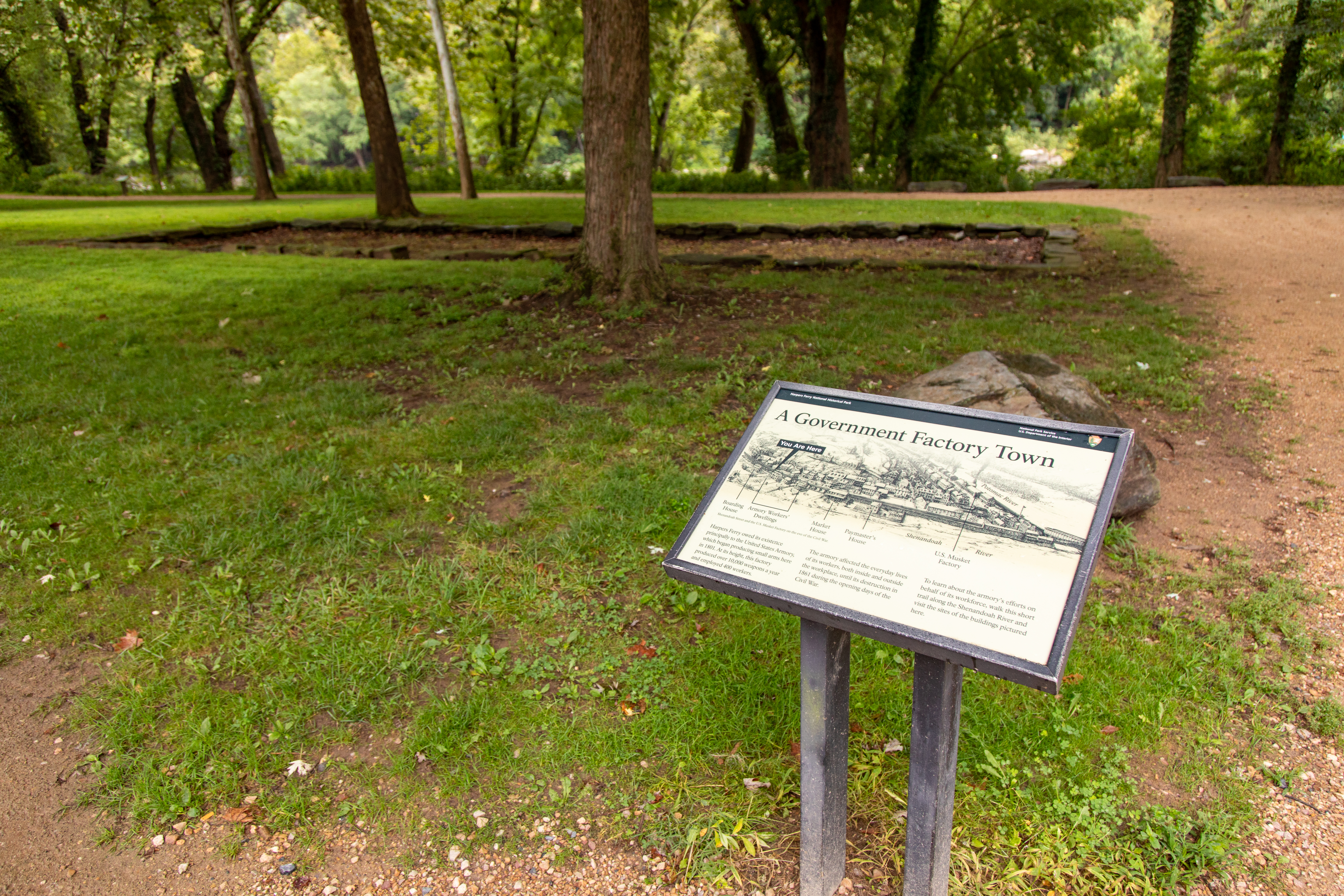
Harpers Ferry owed its existence principally to the United States armory, which began producing small arms here in 1801. At its height, this factory produced more than 10,000 weapons a year and employed 400 workers.The armory affected the everyday lives of its workers both inside and outside the workplace, until its destruction in 1861 during the opening days of the Civil War.To learn about the armory's efforts on behalf of its workforce, walk this short trail along the Shen
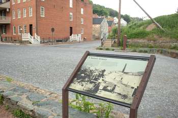
A Government Factory Town. This 2 foot by 2 foot wayside panel is situated just beyond the walkway near the bus stop that underneath the railroad trestle. The bus stop is behind us, on the other side of the trestle and the river is ahead of us. At the top of the panel is a B&W drawing of the booming town of Harpers Ferry on the eve of the Civil War. Buildings cover the hillside and line the shores of the rivers. Smoke billows out of several chimneys. The Shenandoah River runs along the bottom of the drawing and a label indicating "you are here" is at the bottom left, just to the left of the Armory Worker's Dwellings. Text on the panel reads: Harpers Ferry owed its existence principally to the United States armory, which began producing small arms here in 1801. At its height, this factory produced more than 10,000 weapons a year and employed 400 workers. The armory affected the everyday lives of its workers, both inside and outside the workplace, until its destruction in 1861 during the opening days of the Civil War. To learn about the armory's efforts on behalf of its workforce, walk this short trail along the Shenandoah River and visit the sites of buildings pictured here.
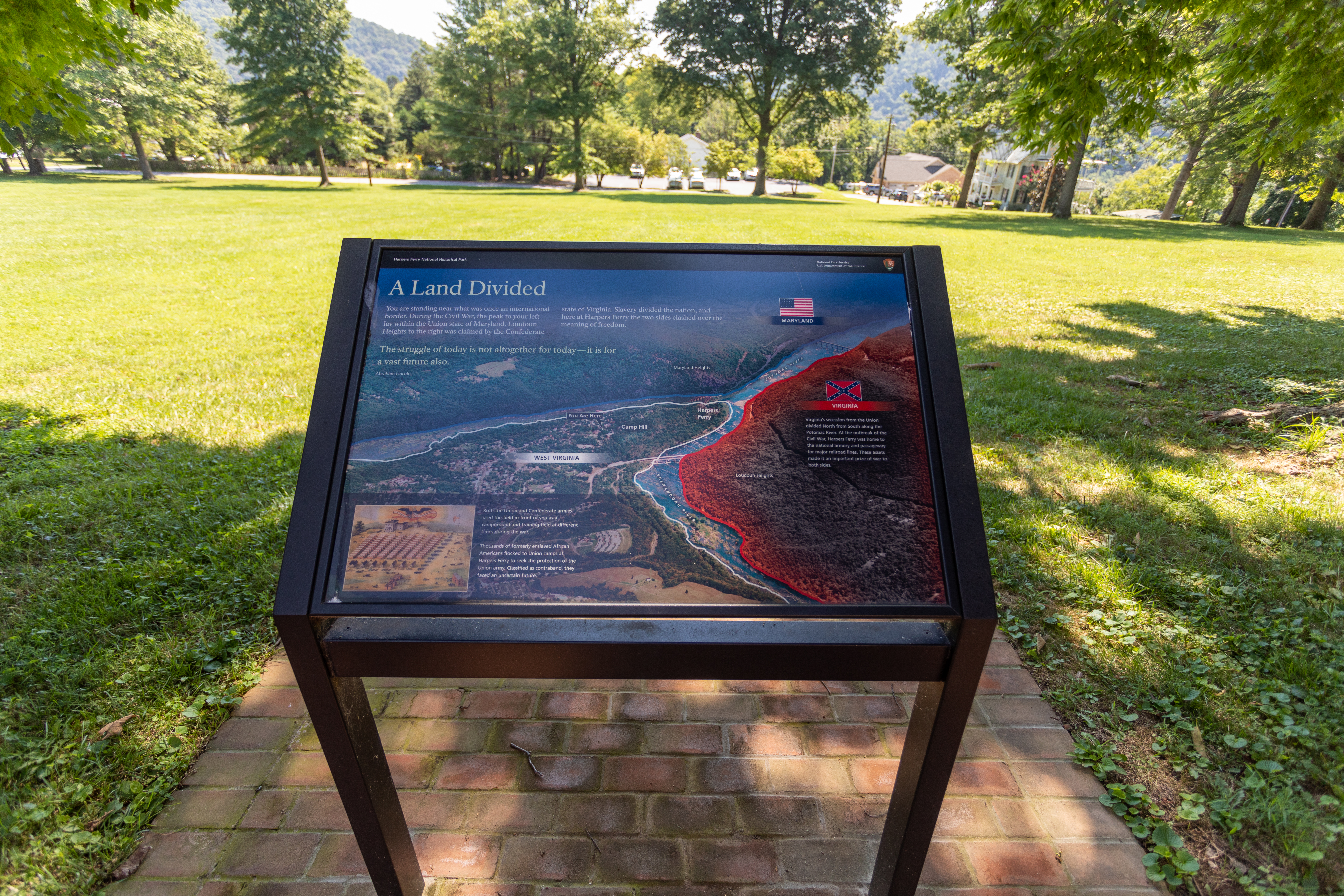
The struggle of today is not altogether for today -- it is for a vast future. - Abraham Lincoln.You are standing near what was once an international border. During the Civil War, the peak to your left lay within the Union state of Maryland. Loudoun Heights to the right was claimed by the Confederate state of Virginia. Slavery divided the nation, and here at Harpers Ferry the two sides clashed over the meaning of freedom.The noise of army camp life once disturbed the quiet
A Land Divided. This 3/12 foot by 2 foot angled wayside panel is mounted in the lawn in front of Cook Hall (to your right). Anthony Hall is across the sidewalk behind you and the Harpers Ferry gap is just visible in the distance beyond the trees and homes in front of you. Text on the panel begins with a quote from Abraham Lincoln: "The struggle of today is not altogether for today - it is for a vast future also." Text continues: You are standing near what was once an international border. During the Civil War, the peak to your left ley within the Union state of Maryland. Loudoun Heights to the right was claimed by the Confederate state of Virginia. Slavery divided the nation, and here at Harpers Ferry the two sides clashed over the meaning of freedom. At the center left of the panel is a color illustration of the field in front of Anthony Hall filled with rows of tents and soldiers. Light red rectangular tents are arranged left to right in 8 rows of 12. Lower in the field, arranged perpendicularly in front of the first row of red tents, is a row of 8 larger white buildings with black roofs and chimneys. To the right of the rows of tents and buildings are 11 groups of soldiers. Scattered about the grounds and among a few other buildings on the outskirts are horse-pulled wagons and people walking about or riding horses. A large American flag flies atop a pole at the top right of the scene and a bald eagle holding a banner in its beak fills the sky above Anthony Hall. Written on the banner are the words: Camp 5th New York Heavy Artillery, Camp Hill, Harpers Ferry, VA. The caption tells us: The noise of army camp life once disturbed the quiet field before you. Both the Union and Confederate armies used this clearing as a campground and training field at different times throughout the course of the war. Inset at the center bottom of the panel is a B&W illustration of a man leading a team consisting of a horse, a mule, and a cow pulling an open-top wagon. A soldier is mounted atop the mule and in the bed of the wagon is a group of 7 African American men, women, and children. A caption reads: Refugees from slavery flocked to the Union encampments in Harpers Ferry. Thousands of formerly enslaved people sought the protection of the Union army. Classified by the army as contraband, they faced an uncertain future. The right-half of the wayside is filled with a B&W aerial photo of Harpers Ferry, Camp Hill, and Bolivar in the late 20th century. Harpers Ferry is located near the top, at the juncture of the Potomac (left) and Shenandoah (right) rivers. Maryland Heights is in the background at the left and Loudoun Heights is along the middle right. The NPS Visitor Center and parking area are visible at the lower right of the picture. The caption here tells us: Virginia's secession from the Union divided North from South along the Potomac River. At the outbreak of the Civil War, Harpers Ferry was home to the national armory and passageway for major railroad lines. These assets made it an important prize of war to both sides.
Why move a building four times? What is special about the building that used to stand here? It is the only building left from the U.S. Armory and the place where John Brown's raid ended. It is the most important building in Harpers Ferry history.In it really began the Civil War. Here was lighted the torch of liberty for all America...For you this is the most hallowed shrine in this country.-Henry McDonald, Storer College presidentIn 1859 abolitionist John Brown led his famou
In it really began the Civil War. <br />Here was lighted the torch of liberty for all America...<br />For you this is the most hallowed shrine in this country.<br />-Henry McDonald, Storer College president<br /><br />In 1859 abolitionist John Brown led his famous raid against slavery on the U.S. Armory and was captured in the fire engine house, now known as John Brown's Fort.<br /><br />The foundations in front of you mark a temporary site of John Brown's Fort, from 1895 to 1909. Originally located in Harpers Ferry, the fort was moved four times in 75 years. Entrepreneurs dismantled it and then rebuilt it on location at the 1893 Columbian Exposition in Chicago. After this exhibition, journalist Kate Field saved the fort from demolition b raising the funds to move it here to Murphy Farm. In 1909 Storer College President Henry McDonald brought the fort to the college's Harpers Ferry campus. After the closing of Storer College the National Park Service returned the fort near its original location in Harpers Ferry (lower town), where it stands today.
You are standing directly across the street from the main entrance of one of the nation's first military industrial complexes. The U.S. Armory at Harpers Ferry, now covered by an embankment of dirt and rubble, produced the deadliest weapons of its day from the early 1800s until the start of the Civil War in 1861. Gutted during the Civil War, the armory was later razed and mostly covered with rubble to make way for elevated train tracks. A stone obelisk on the rise in front
This 3 ½ foot by 2 foot angled wayside panel is situated at the end of Shenandoah Street; John Brown's fort and The Point are behind you. The panel features a historic B&W photo of the armory grounds as they appeared during the Civil War. A tall iron gate is open to a wide flat dirt road that runs vertically through the photo. The row of imposing armory buildings line the right side of the road, with a dark chimney towering from the center. On the left side of the road, beyond a stone and iron fence, John Brown's fort stands in its original location with trees and other buildings visible in the background. The text tells us: You are standing directly across the street from the main entrance of one of the nation's first military industrial complexes. The U.S. Armory at Harpers Ferry, now covered by an embankment of dirt and rubble, produced the deadliest weapons of its day from the early 1800s until the start of the Civil War in 1861. Gutted during the Civil War, the armory was later razed and mostly covered with rubble to make way for elevated train tracks. A stone obelisk on the rise in front of you marks the original location of what became known as John Brown's Fort.
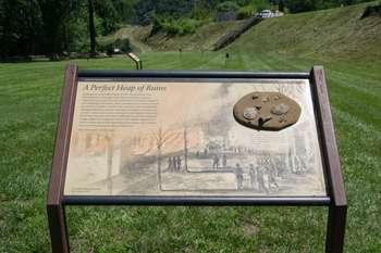
Standing here on the night of April 18, 1861, you would have seen the billowing smoke as fire raged in the armory workshops upstream. Virginia had just seceded from the United States and Virginia militiamen were advancing on the armory. Vastly outnumbered and unable to defend the armory, U.S. soldiers "set fire to the Carpenter shop & grinding mill. Stocking shop, & the 2 arsenals" leaving the buildings in a "perfect heap of ruins," wrote a local resident. Arriving after t
Standing here on the night of April 18, 1861, you would have seen the billowing smoke as fire raged in the armory workshops upstream. Virginia had just seceded from the United States and Virginia militiamen were advancing on the armory. Vastly outnumbered and unable to defend the armory, U.S. soldiers "set fire to the Carpenter shop & grinding mill. Stocking shop, & the 2 arsenals" leaving the buildings in a "perfect heap of ruins," wrote a local resident. Arriving after the Federals retreated and the fire had consumed most of the 15,000 rifles stored in the arsenal, the Virginia Militia later stripped the armory of its valuable machinery. An Armory worker lamented the destruction of the armory "Our armory is burnt and we have no money and no nothing else."<br /><br />The armory never operated again.
In 1862 Union Colonel Dixon Miles thought that the ridge in front of you, Bolivar Heights, was the perfect place to defend Harpers Ferry. However, in September of '62, Colonel Miles and 14,000 Union soldiers found themselves surrounded by 24,000 Confederates led by "Stonewall" Jackson. From the Confederate position behind you on School House Ridge, one of Jackson's officers described Bolivar Heights as "a position strong by nature." Jackson agreed. He had no time for a siege
This 3 ½ foot by 2 foot angled wayside panel is mounted so you are facing toward the tree line along the top of Bolivar Heights on the hill above. Bakerton Road is behind you and a bench is to your right. Text on the panel reads: In 1862 Union Colonel Dixon Miles thought that the ridge in front of you, Bolivar Heights, was the perfect place to defend Harpers Ferry. However, in September of 1862, Colonel Miles and 14,000 Union soldiers found themselves surrounded by 24,000 Confederates led by "Stonewall" Jackson. From the Confederate position behind you on School House Ridge, one of Jackson's officers described Bolivar Heights as "a position strong by nature," Jackson agreed. He had no time for a siege and didn't want to risk an attack up the steep slope of Bolivar Heights. Jackson planned a fake attack here to cover a full-scale assault against a weaker Union position on the southern end of Bolivar Heights. Following a full afternoon of artillery bombardment on September 14, the Confederate plan began to unfold. Inset at the bottom are two oval-shaped B&W tintype portraits. At the left is Colonel Dixon Miles. He has gray hair and a clean-shaven face and wears a high-collared dark uniform jacket. Next, is General "Stonewall" Jackson. He was dark hair and a full beard and mustache. He wears a grey uniform jacket. On the right half of the panel is a map of Harpers Ferry centered toward the top at the confluence of the Potomac and Shenandoah rivers. Loudoun Heights is at the right, across the Shenandoah River, and Maryland Heights is at the left, across the Potomac River. Blue rectangles indicated Miles' Union troops at Bolivar Heights, near a "You Are Here" label. Red rectangles show Confederate troops at Maryland Heights, Loudoun Heights, and along School House Ridge. A quote from "Stonewall" Jackson tells us: "In the afternoon General Hill was ordered to move along the left bank of the Shenandoah, turn the enemy's left, and enter Harper's Ferry... General J.R. Jones was directed to make a demonstration against the enemy's right."
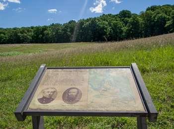
The first large scale Federal occupation of Harpers Ferry began in February 1862. Despite the destruction of the armory and arsenal the previous year, Harpers Ferry remained important in protecting Union communication and supply lines in deterring Confederate invasions of the North.The Confederates invaded the North for the first time in September 1862. By September 7, Gen. Robert E. Lee's army had crossed the Potomac River and encamped outside Frederick, Maryland. The lar
A Union Predicament. This 3 ½ foot by 2 foot angled wayside panel is oriented with Harpers Ferry gap and the Potomac River between Maryland (left) and Virginia (right) visible straight ahead in the distance. Text on the panel reads; The first large-scale Federal occupation of Harpers Ferry began in February 1862. Despite the destruction of the armory and arsenal the previous year, Harpers Ferry remained important in protecting Union communication and supply lines and in deterring Confederate invasion of the North. At the bottom left is an illustration of rows of troops marching in the foreground with Harpers Ferry visible in the background across the river. The caption: By early September 1862, 14,000 Federal troops occupied Harpers Ferry and vicinity, with more than half encamped on Bolivar Heights. Text continues: The Confederates invaded the North for the first time in September 1862. By September 7, Gen. Robert E. Lee's army had crossed the Potomac River and encamped outside Frederick, Maryland. The large Union force at Harpers Ferry, now located behind the invading Confederates, threatened Southern communication and supply lines. In response, Lee boldly divided his army into four parts, sending three columns to capture or destroy the Union garrison at Harpers Ferry. At the right of the panel is an illustration of the Potomac River running diagonally from the bottom of the panel at the left and almost to the top at the right. The Shenandoah River intersects the Potomac midway from the bottom right. Maryland is noted at left, Virginia is noted at right, and the section of Virginia that is now West Virginia is at the bottom. Red arrows show troop movements. From the top, Lee's troops move from Virginia into Frederick, Maryland. Next, Walker's troops cross the Potomac River at Point of Rocks, Maryland, and in to Harpers Ferry. McLaws' troops advance from Frederick toward Maryland Heights. Maj. Gen. Lafayette McLaws' Confederate force of 8,000 captured Maryland Heights after a battle there on September 13. And Jackson's troops travel in a U-shape from Frederick, Maryland, cross the Potomac at Williamsport, MD, and advance through Martinsburg, West Virginia, in to Harpers Ferry. Maj. Gen. Thomas J. "Stonewall" Jackson's Confederate force of 14,000 travelled 51 miles in three days and occupied School House Ridge, ½ mile west of Bolivar Heights on September 13. After Jackson's column cornered the Federal into an inescapable position on Bolivar Heights, the trap was set. For five hours on Sunday afternoon, September 14, the Confederates fired their artillery from the captured heights. One hapless Federal wrote: "...this hissing and screeching of shot and shell discharged at us...twas a strange medley for a Sabbath day's worship." A quote at the top right from Maj. Gen, John G. Wool, USA, Telegraphic message to Col. Dixon S. Miles, USA, September 7, 1862: "Do all you can to annoy the rebels should they advance on you...You will not abandon Harpers Ferry without defending it to the last extremity."
The first large-scale Federal occupation of Harpers Ferry began in February 1862. Despite the destruction of the armory and arsenal the previous year, Harpers Ferry remained important in protecting Union communication and supply lines and in deterring Confederate invasions of the North. The Confederates invaded the North for the first time in September 1862. By September 7, Gen. Robert E. Lee's army had crossed the Potomac River and encamped outside Frederick, Maryland. The l
The first large-scale Federal occupation of Harpers Ferry began in February 1862. Despite the destruction of the armory and arsenal the previous year, Harpers Ferry remained important in protecting Union communication and supply lines and in deterring Confederate invasions of the North. The Confederates invaded the North for the first time in September 1862. By September 7, Gen. Robert E. Lee's army had crossed the Potomac River and encamped outside Frederick, Maryland. The large Union force at Harpers Ferry, now located behind the invading Confederates, threatened Southern communication and supply lines. In response, Lee boldly divided his army into four parts, sending three columns to capture or destroy the Union garrison at Harpers Ferry. <br /><br />Quotation: "Do all you can to annoy the rebels should they advance on you . . . . You will not abandon Harpers Ferry without defending it to the last extremity." Maj. Gen. John G. Wool, USA Telegraph message to Col. Dixon S. Miles, USA September 7, 1862 <br /><br />Illustration caption: By early September 1862, 14,000 Federal troops occupied Harpers Ferry and vicinity, with more than half encamped on Bolivar Heights. <br /><br />Map caption: After Jackson's column cornered the Federals into an inescapable position on Bolivar Heights, the trap was set. For five hours on Sunday afternoon, September 14th the Confederates fired their artillery from the captured heights. One hapless Federal wrote: "... the hissing and screeching of shot and shell discharged at us 'twas a strange medley for a Sabbath day's worship."
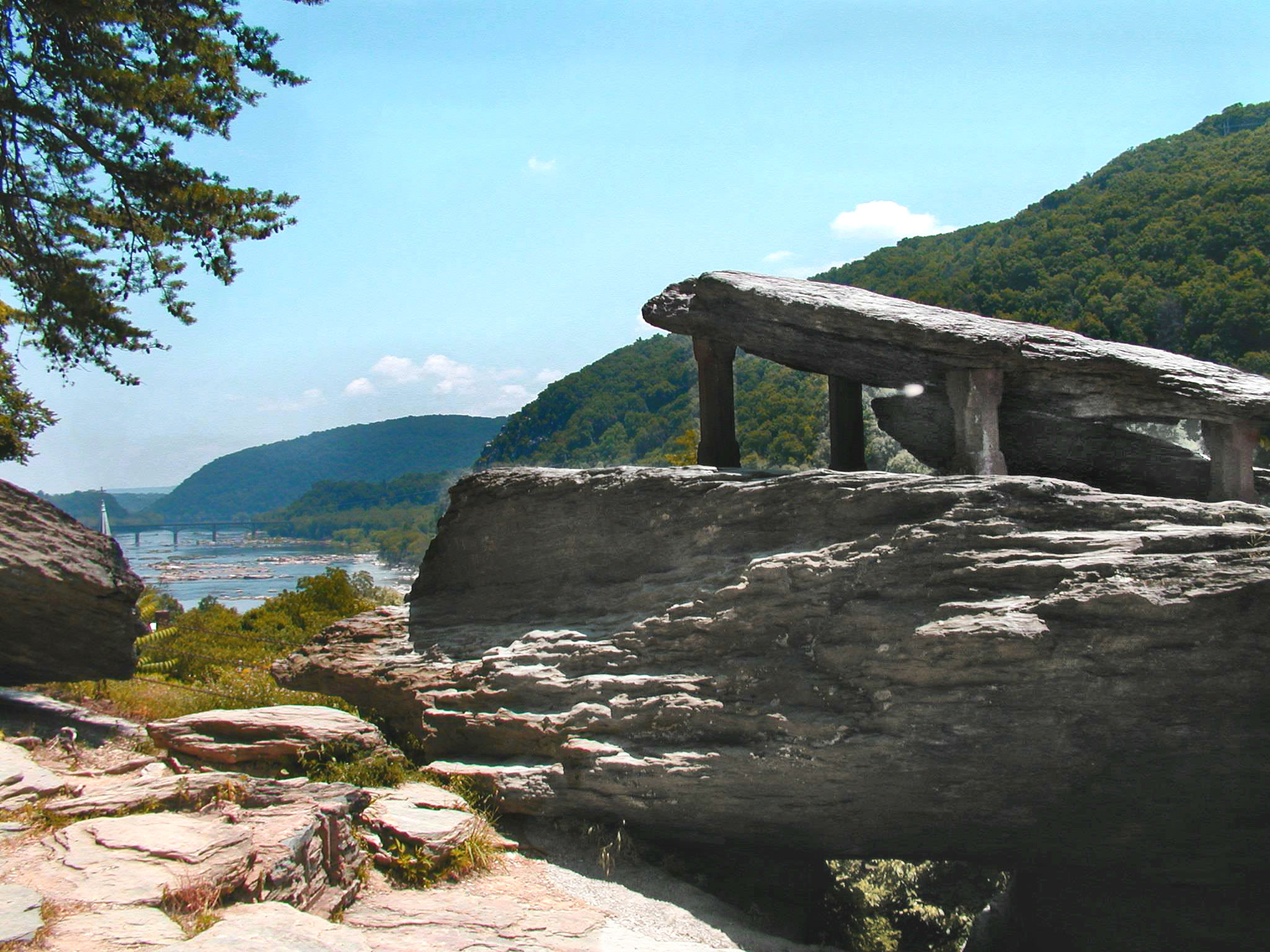
The stone steps to your left are part of the Appalachian Trail-- a 2,200-mile footpath from Georgia to Maine. Climb the steps to some of the most scenic views in Harpers Ferry. Walk 300 yards to Jefferson Rock for a view that Thomas Jefferson described as "worth a voyage across the Atlantic." <br />Take a side trail to Lockwood House, Storer College, and the Appalachian Trail Visitor Center. Or keep walking 1,000 miles south to Springer Mountain, Georgia.
A Journey of 1,000 Miles Begins With a Single Step wayside and historic stone steps. This 3 ½ foot by 2 foot angled wayside panel is found just to the right of the historic stone steps leading up to St. John's Church and beyond. The background photo of the panel features a panoramic color photo of Harpers Ferry as seen from across the river at Loudoun Heights in 2009. The Appalachian National Scenic Trail is depicted as a white-dashed line that passes through the town from the Shenandoah River bridge on the left to continue over the Potomac River bridge at the right. Wayside Text: "A journey of 1,000 miles begins with a single step." -Lao Tzu. The stone steps to your left are part of the Appalachian Trail - a 2,200-mile footpath from Georgia to Maine. Climb the steps to some of the most scenic views in Harpers Ferry. Walk 300 yards to Jefferson Rock for a view that Thomas Jefferson described as "worth a voyage across the Atlantic." Take a side trail to Lockwood House, Storer College, and the Appalachian Trail Visitor Center. Or keep walking 1,000 miles south to Springer Mountain, Georgia. Begin your journey here. A series of B&W and color photos is inset across the middle of the panel and depicts other sites around the park. From left to right they are: Historic Storer College, 0.6 miles. Visit the former Storer College campus - one of America's first black colleges. Appalachian Trail Visitor Center, 0.8 miles. Learn more about the Appalachian Trail. Lockwood House, 550 yards. Take a side trail for scenic views from the Lockwood House. Jefferson Rock, 300 yards. Stop for pictures at this historic landmark. Stone Steps. Climb the hand-carved steps to St. Peter's Catholic Church. The Appalachian Trail, "Thru-hikers" complete the entire trail through 14 states in one continuous six-month trip. To the left of this panel are the historic stone steps, with St. John's steeple visible at the top. Iron handrails line both sides of the wide stairway but the hand-carved and worn steps are uneven and are set at different heights and depths. There are 59 steps to navigate before reaching Public Way road beside Harper House. A sign nearby warns: Caution. Surfaces may be uneven. Watch your step.
Rank has its privileges. The paymaster, second in command at the armory, enjoyed an unobstructed view of the factory grounds and the water gap from the substantial brick dwelling erected here about 1800. Soot and noise disrupted the scene with the arrival of the Winchester and Potomac Railroad through the paymaster's front yard in 1836. The paymaster relocated to new, elegant quarters on the hill overlooking the river gap. Following this move, the government leased the old st
Rank has its privileges. The paymaster, second in command at the armory, enjoyed an unobstructed view of the factory grounds and the water gap from the substantial brick dwelling erected here about 1800. Soot and noise disrupted the scene with the arrival of the Winchester and Potomac Railroad through the paymaster's front yard in 1836. The paymaster relocated to new, elegant quarters on the hill overlooking the river gap. Following this move, the government leased the old structure to armory workers. <br /><br />Photo Caption: River view of the original paymaster's house, c. 1885-1890.
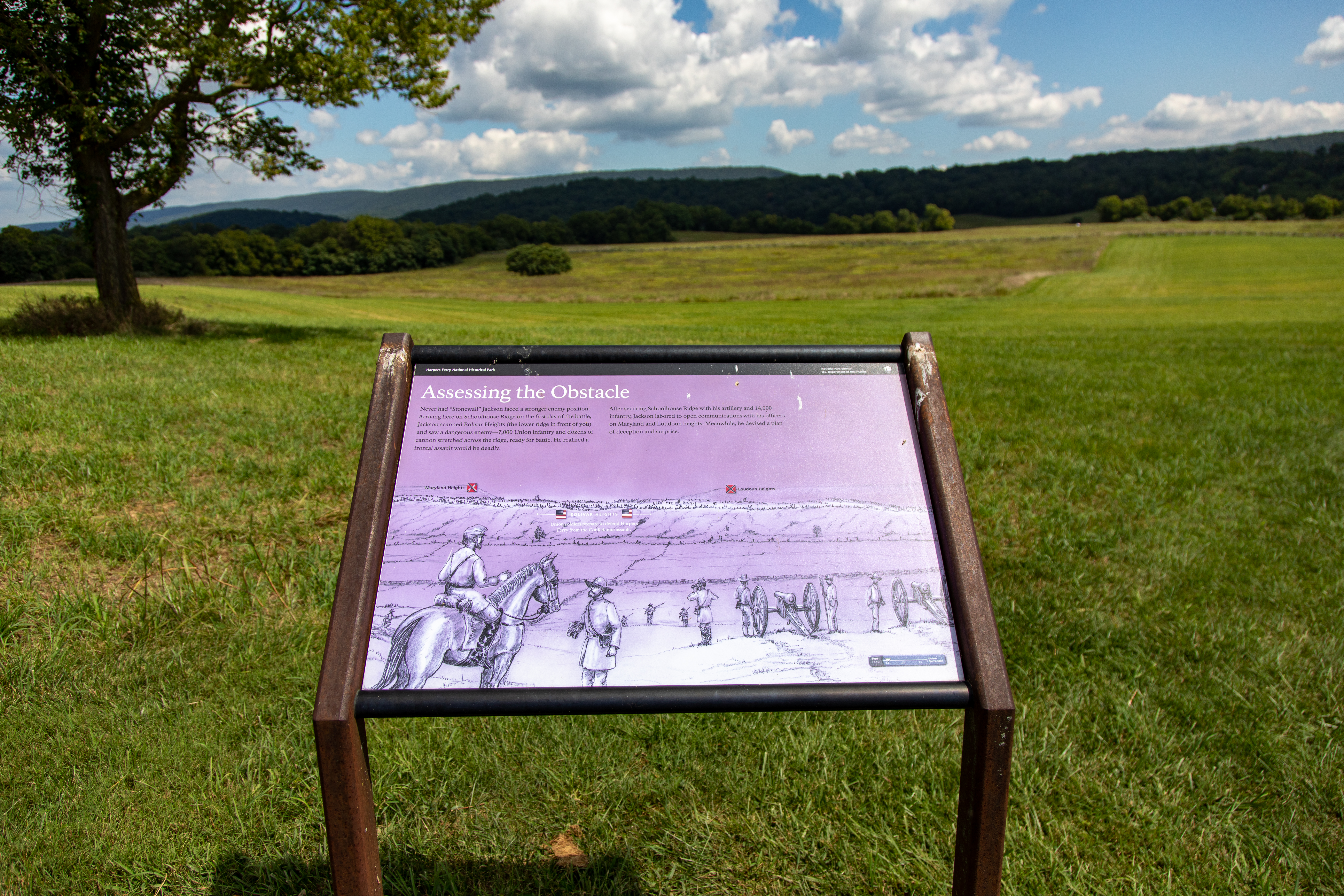
Never had "Stonewall" Jackson faced a stronger enemy position. Arriving here on Schoolhouse Ridge on the first day of the battle, Jackson scanned Bolivar Heights (the lower ridge in front of you) and saw a dangerous enemy - 7,000 Union infantry and dozens of cannons stretched across the ridge, ready for battle. He realized a Front assault.After securing Schoolhouse Ridge with his artillery and 14,000 infantry, Jackson labored to open communications with his officers on Maryla
Never had "Stonewall" Jackson faced a stronger enemy position. Arriving here on Schoolhouse Ridge on the first day of the battle, Jackson scanned Bolivar Heights (the lower ridge in front of you) and saw a dangerous enemy - 7,000 Union infantry and dozens of cannons stretched across the ridge, ready for battle. He realized a Front assault.<br /><br />After securing Schoolhouse Ridge with his artillery and 14,000 infantry, Jackson labored to open communications with his officers on Maryland and Loudoun heights. Meanwhile, he devised a plan of deception and surprise.
The Visitor Center is located at the main entrance of the park at 171 Shoreline Drive, Harpers Ferry, WV 25425. Visitors may ask questions, pick up park maps and brochures, and more. From this location, visitors may park their vehicles and take a shuttle bus to the Lower Town district of the park. *Park passports stamps located at Bookshop in Lower Town* *Purchase park entrance passes at the entrance station, located just outside the Visitor Center parking area*
The Lower Town Information Center is not currently staffed by rangers. However, maps and information are available at the "Place in Time" exhibit space.
Murphy Farm is one of several places that are great to explore with your leashed dog. The trails offer a walk along the farm lane, through the woods, and along the fields. You also take in the view of the Shenandoah River.
Bicycle from Williamsport to Harpers Ferry
Want to explore history and enjoy a day bicycling? This is the route for you. Enjoy a leisurely 40-mile bike ride, or choose to hike and or paddle the length instead, spending the night camping or staying in paid accommodations. Historic treasures await you in Williamsport, Shepherdstown, and Harpers Ferry along the way.
Hike Civil War Skirmish Lines at Harpers Ferry
Did you know the park has over 20 miles of hiking trails? The trails vary from easy, riverside strolls to four-mile hikes across Civil War battlefields to eight-mile adventures on the tops of mountains.
Visit The Point at Harpers Ferry
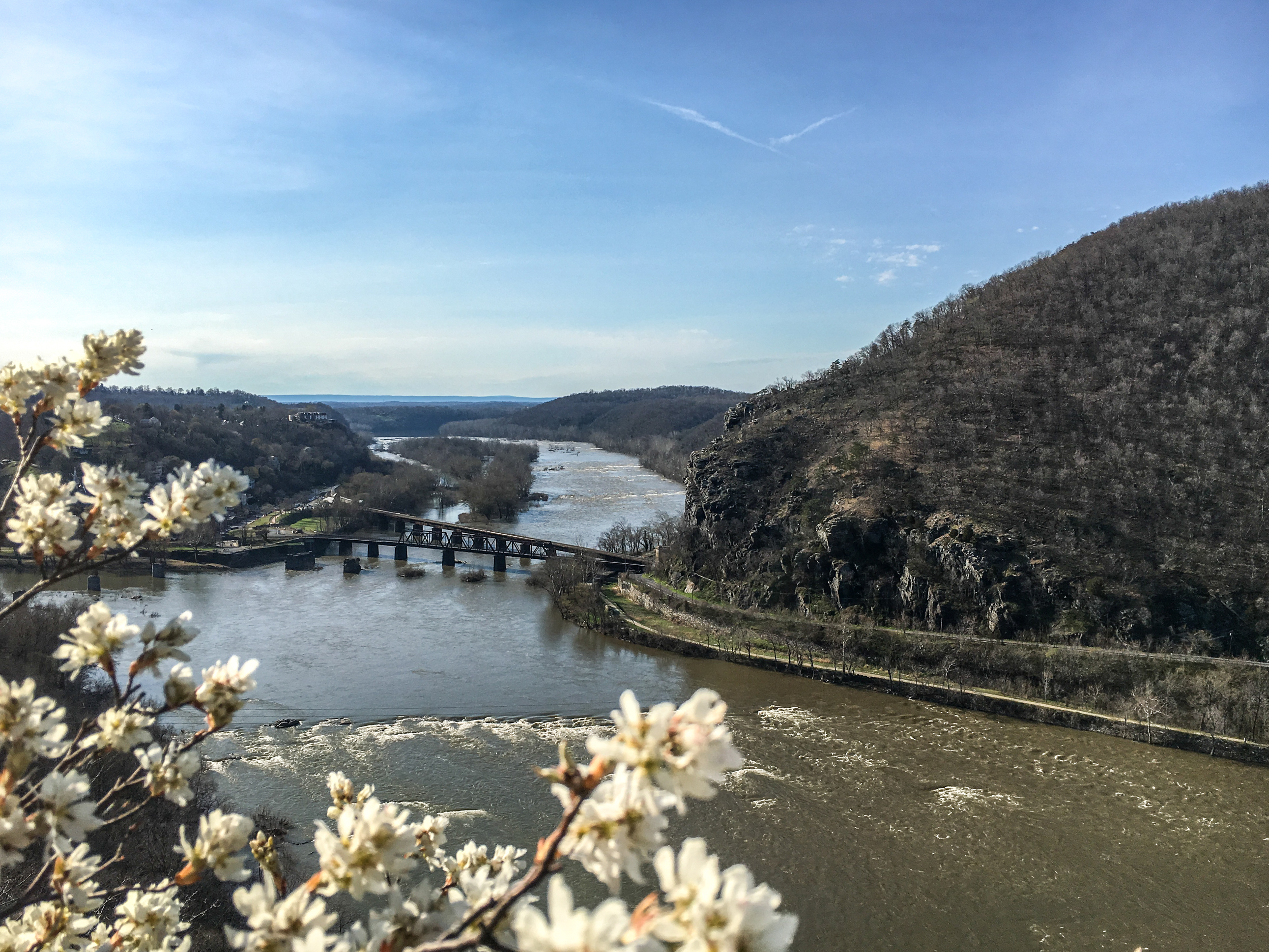
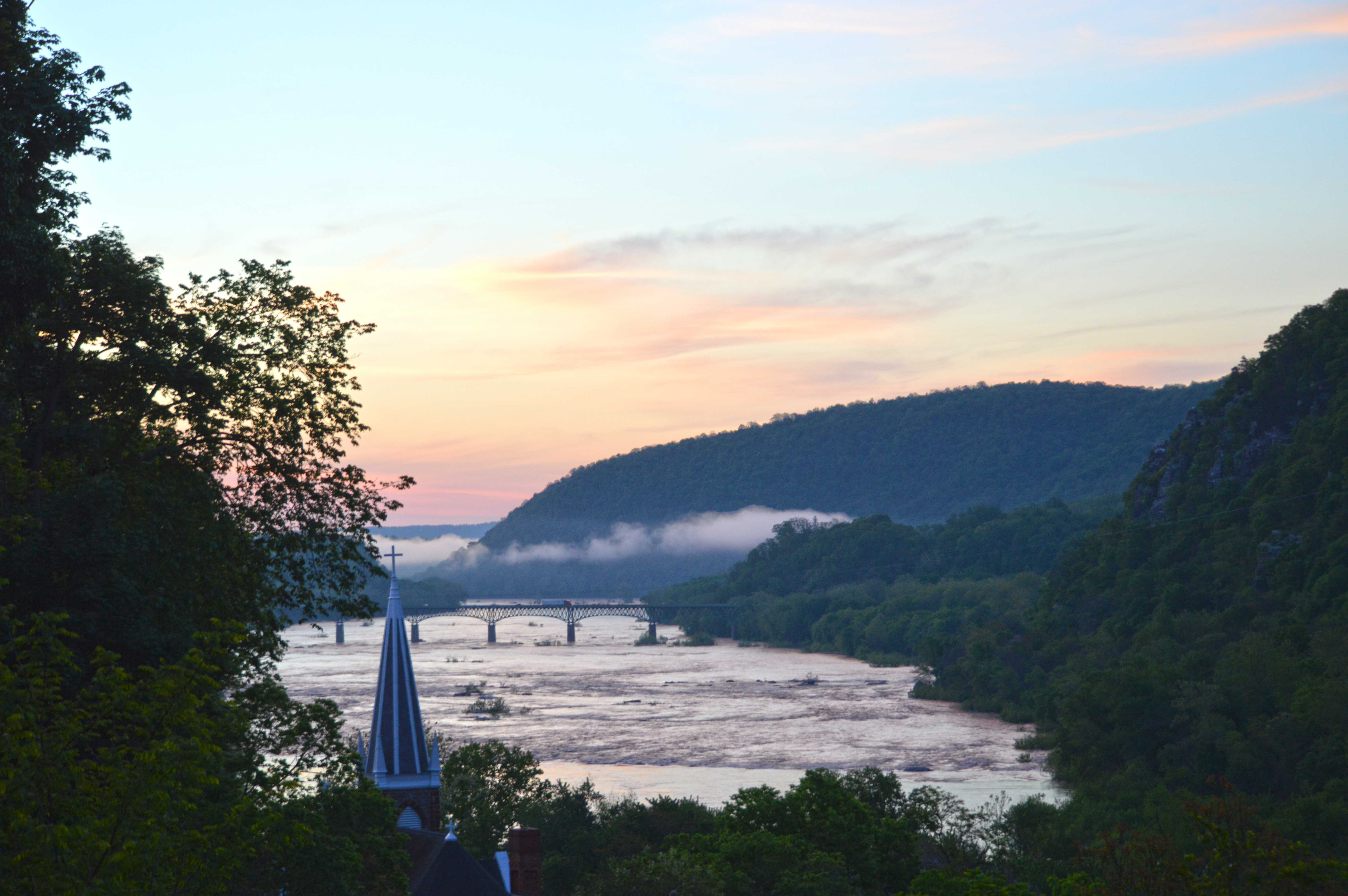
Visit where the Potomac and Shenandoah rivers meet! From this location, known as The Point, you look upon three states - Maryland, Virginia, and West Virginia - as well as the confluence of the two rivers. We invite you to visit in any season to gaze upon the magnificent sight of this water gap in the Blue Ridge Mountains.
Step Back in Time at Jefferson Rock
Jefferson Rock is a popular destination in Harpers Ferry. It is situated along the Appalachian Trail between the Lower Town and Camp Hill areas of the park.
Visit John Brown's Fort
A visit to John Brown's Fort is more than seeing the building where John Brown and several of his followers barricaded themselves in 1859. The building has a complex history that begins in 1848, continues through to today, and includes four locations in Harpers Ferry and one in Chicago. We invite you to visit this famous Harpers Ferry building and discover what it means to you.
Visit Jefferson Rock
Hike along the Appalachian Trail in Harpers Ferry, WV to see the view Thomas Jefferson once described as "one of the most stupendous scenes in Nature."
Tours
Count: 4
Civil War Battlefields Driving Tour
Drive to four Civil War battlefields: Bolivar Heights, Schoolhouse Ridge North, Schoolhouse Ridge South, and Murphy-Chambers Farm. Explore the sites significant to the 1862 Battle of Harpers Ferry. Number of stops: 5 stops Estimated tour time Driving only: about 30 minutes Diving and hiking: about 2 hours
Meriwether Lewis at Harpers Ferry
Meriwether Lewis relied on the U.S. Armory and Arsenal at Harpers Ferry for weapons and hardware for his transcontinental expedition. Lewis spent a total of 36 days at Harpers Ferry from March 16 to April 18, 1803, and again July 7-8, 1803, before departing for Pittsburgh and the Ohio River.
Seeking Freedom
This tour will take you through six stories of people who fought for freedom and equality. You will traverse sidewalks and gravel paths. All stops are accessible to individuals in wheelchairs, although some terrain may be bumpy. It will take about 30 minutes and a half mile of walking to complete. There is an audio and written version of this tour. After each story there are reflection questions. We invite you to use these to reflect on your own experiences.
Storer College
Following the Civil War there were over 30,000 freedmen living in the Shenandoah Valley. Recognizing the need for education, the Freedmen's Bureau, the Freewill Baptists of New England, and John Storer, came together and Storer College was born. The school survived for 88 years, enriching the lives of hundreds of students. Today you can walk the grounds of this former college campus. The route below starts at the Lockwood House but you can follow it in any order you prefer.