Be advised that the NPS has issued alerts for this park.
Closure: Portion of the Awatixa Trail
The river bank section of trail below the Sakakawea Village and continuing upriver to the parking access with is currently closed due to ongoing erosion and project work.
Earthlodge people hunted bison and other game, but were in essence farmers living in villages along the Missouri and its tributaries. The site was a major Native American trade center for hundreds of years prior to becoming an important market pl...
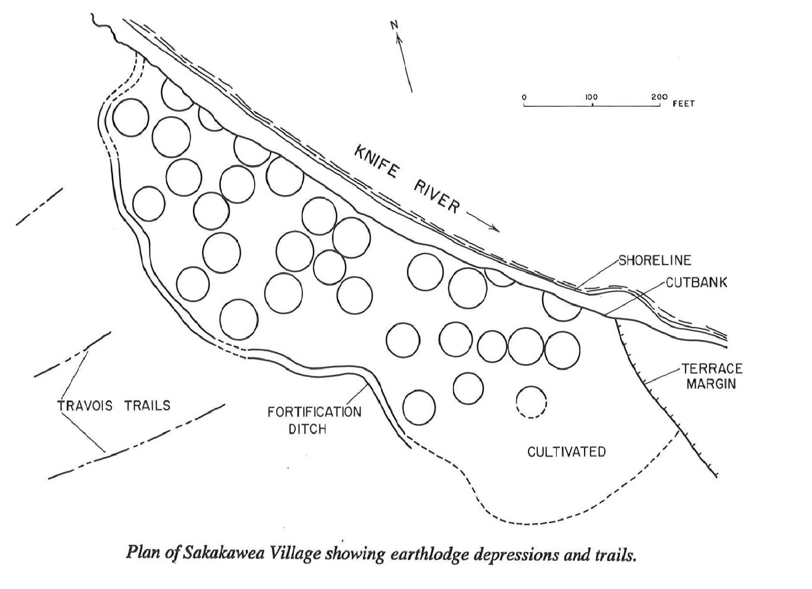
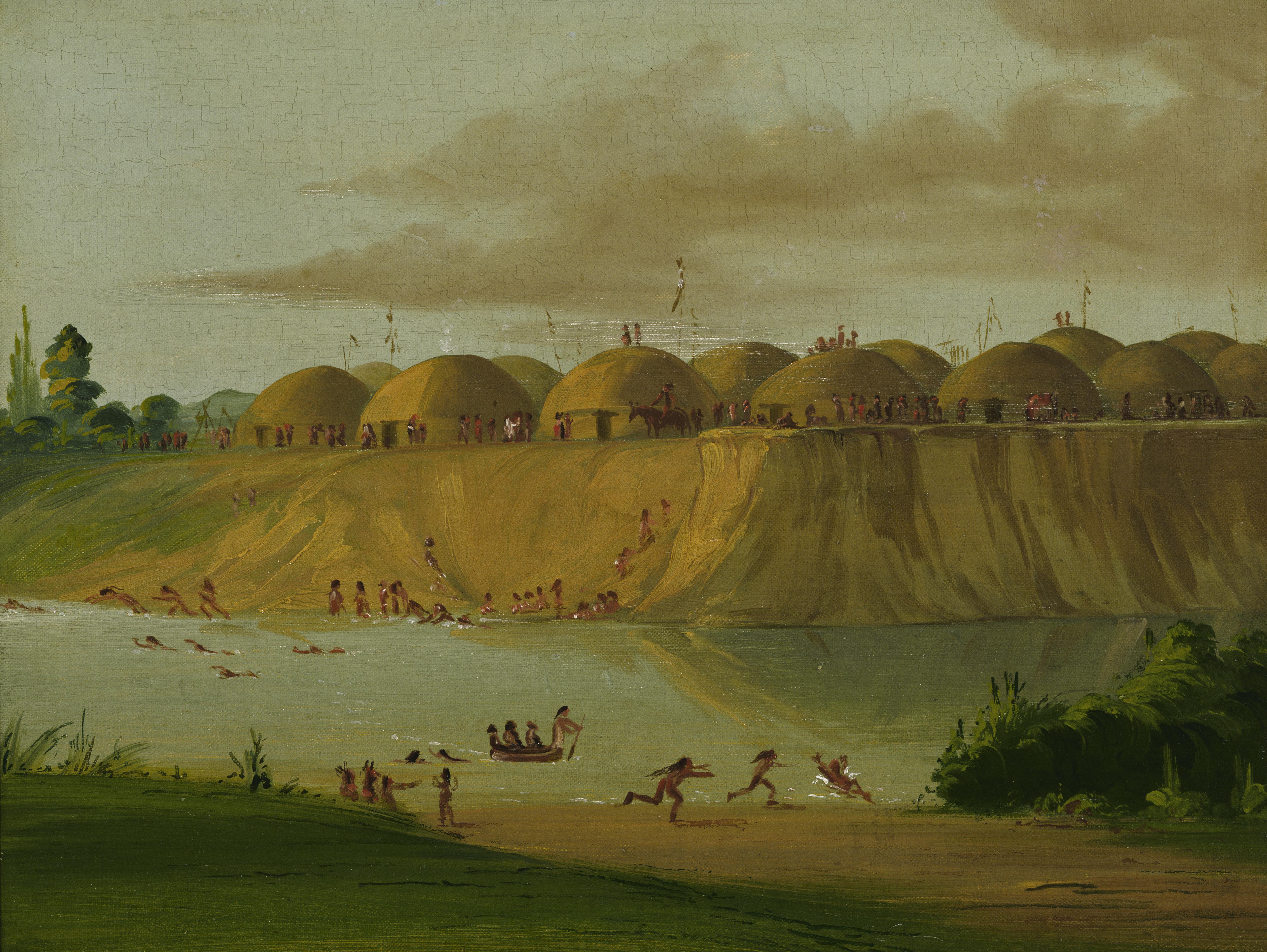
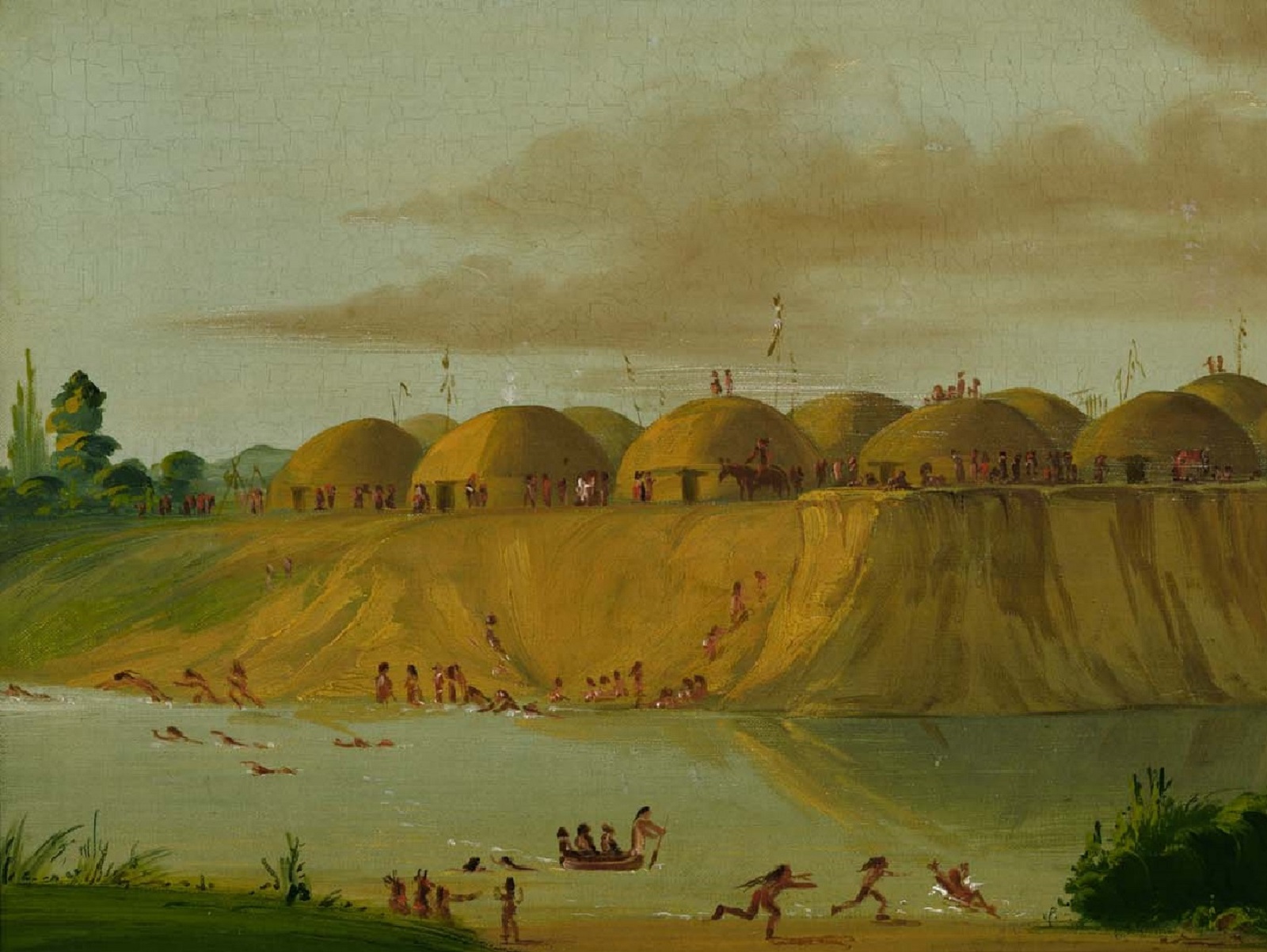
Within10 years, the reconstituted Awatixa returned to their ancestral land to build a new village. It is known as today Awatixa or Sakakawea Village. They lived here from 1790-1834. Historical records indicate from 40 to 60 lodges were here at different times. Currently there are 31 visible depressions. The Sakakawea village archeology site was named after Sacagawea Charbonneau who joined the Lewis and Clark expedition to the Pacific Ocean as a guide and interpreter. Her and her husband Toussaint Charbonneau lived in this village before and after their adventure on the Corps of Discovery. Toussaint Charbonneau lived here most of his life. What does the wayside sign tell us? Awatixa Village (Ah-wah-TEE-Khah) Disappearing Village Site The river that nurtured Awatixa Village is erasing evidence of its existence. In 1798, explorer-trader David Thompson estimated fifty-two earthlodges here. As of 1990, one thirty-one earthlodge depressions remained. Cutbank erosion and channel shifting had washed away at least six, partially destroyed another six, and modern farming had obliterated ten others. To protect the site from future flooding and ice jams, the park has constructed a berm along the river’s edge. Images remain. In 1832, George Catlin visited the village, stayed several weeks, and painted the view from the opposite bank. Though Catlin was a self-taught artist and his technique sometimes appears clumsy, his cultural impressions were accurate. Caption under image: Most historians agree that Toussaint Charbonneau and probably his wife Sakakawea lived in this village. When Lewis and Clark camped in the area, they hired Charbonneau as an interpreter for the expedition. Photo: George Catlin's Hidatsa Village on the Knife River
The upper Missouri region was dotted with earthlodge villages, during the Plains Village Period, for over 1000 years.
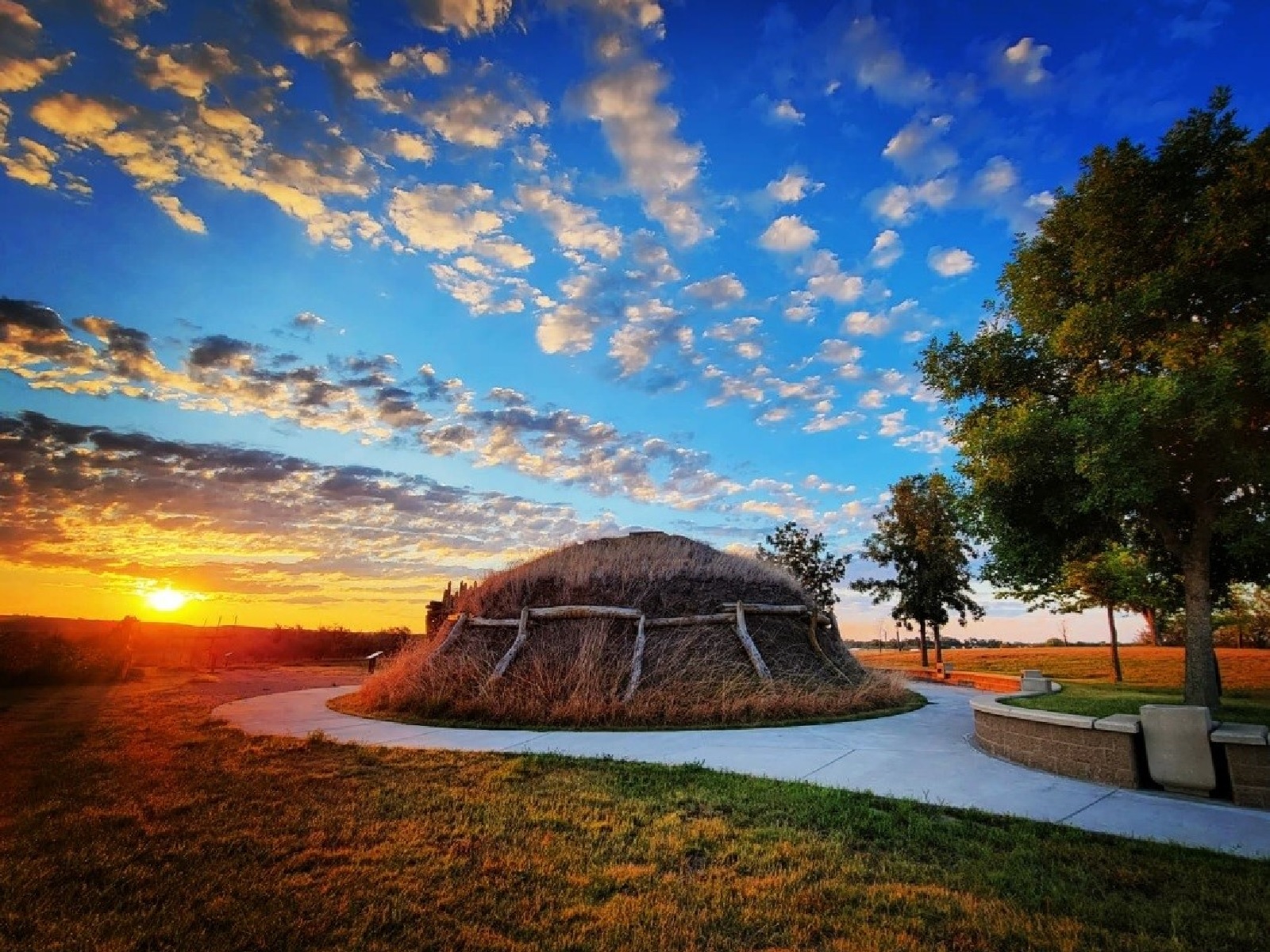
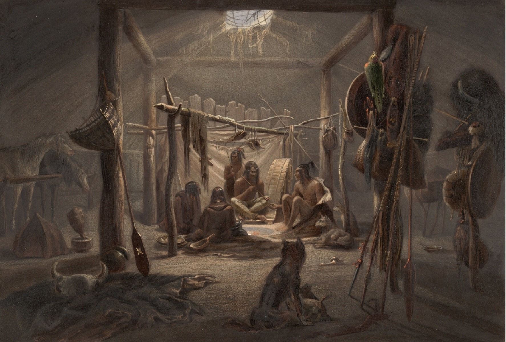
Outside: A brown, dome shaped lodge with a daisy chain of logs supporting sod covering on the sides and roof. The lodge is surrounded by a concrete sidewalk, brick seating, young trees and green lawn overlooking grass fields. Entrance is a hall built with smaller vertical logs with a roof of similar material. Inside: The houses of the village-dwelling tribes on the upper Missouri usually were circular in shape, the larger houses averaging about thirty feet in diameter. Their design incorporated four center wooden pillars and an adjoining framework of posts and beams supporting numerous rafters and wall poles. Over these was laid a matting of willow and grass and an outer, insulating later of earth. A hole in the roof admitted some light and otherwise vented the smoke from a central firepit in the floor. An exterior, moveable screen shielded the vented from the wind and rain. The entrance to the interior was protected from the weather by a covered passageway. Description by David Hunt, Director, Stark Museum, Orange, Texas, USA
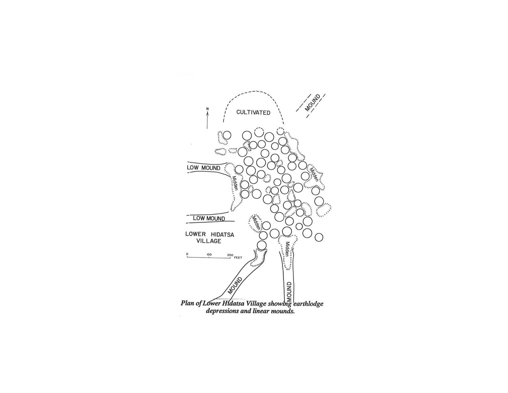
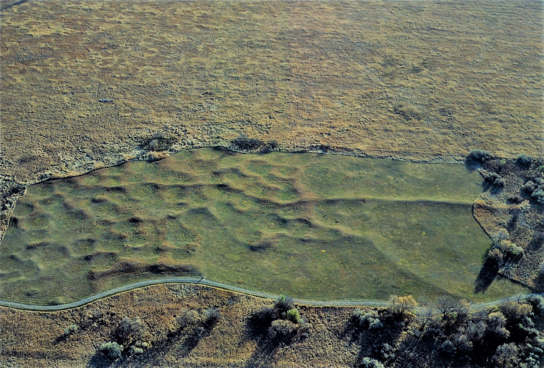
Awatixa Xi'e Village, also known as Lower Hidatsa Village, was established as early as 1525 and continuously occupied for 250 years until about 1780-1785. Home to the Awatixa, a Hidatsa subgroup, this lively village covered an area of about 10 acres and contained at least 51 earthlodges. An estimate of 500-600 people lived in the village, 10 to 30 per lodge. The Hidatsa oral tradition state the Awatixa subgroup claim no other homeland other than the region along the Missouri near the Knife River. The Awatixa also state they were here long before Hidatsa proper and Awaxawi, another Hidatsa subgroup, arrived. Many generations lived in Awatixa Xi’e Village, Lower Hidatsa. They farmed, gathered and hunted food.They were devout in their beliefs and incorporated their spirituality in everything they did. They gave freely, food and clothing, to all in need and no one in the village ever went hungry. This area was a major trading center, like a modern-day mall. People came from far and wide to trade goods. The corn and Knife River flint were the best-selling items. One could also trade beads, horses, produce, meats, hides, bison robes, beaded clothing for anything you wanted if you could negotiate a fair trade. Wayside: Awatixa Xi'e Village (Ah-wah-TEE-Khah) (Eh) Circles in the Earth You are at the Edge of the large village of earthlodges. When the dwellings collapsed, they left circular mounds of earth around hardened, saucer-like floors. From that pattern you can picture the extent of this village and speculate about the number of inhabitants. The bowl-shaped earthlodge depressions are surprisingly close together, leaving barely enough room for corn-drying scaffolds between dwellings. On sprawling prairie this crowded design suggests a close-knit social structure or the need for protection against marauding tribes. Sketch of an unfinished earthlodge wooden framework. These earthlodges measure thirty to sixty feet in diameter-large enough for an extended family of five of their best horses. At least five inches of earth covered a wooden framework of rafters and support posts. Photo: Arial view of Lower Hidatsa Fifty-one earthlodge depressions are clearly visible from the air. According to archeological evidence, people occupied the site for centuries before the Awatixa built this village. They abandoned it after the smallpox epidemic in 1780, but later returned and built a new village at the river's edge.
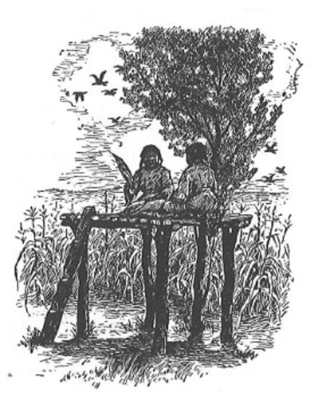
Small gardens on the left and right in the summer and spring. Otherwise the garden sits fallow. Wayside: Hidatsa Garden With simple tools, Hidatsa women grew corn, beans, squash, and sunflowers in the fertile soil along the Missouri and Knife Rivers. “My grandmother Turtle made scarecrows to frighten away the birds…she drove two sticks for legs, and bound two other sticks to them for arms: on the top she fastened a ball of cast-ways skins…Such a scarecrow looked wicked!” Picture: Hidatsa woman hoeing with bone hoe, 1912 Buffalo Bird Woman, known in Hidatsa as Maxidiwiac, was born about 1839, in an earthlodge along the knife River in present day North Dakota. In 1845, her people moved upstream and built Like-a-fishhook village, which they shared with the Mandan and Arikara. There Buffalo Bird Woman grew up to become an expert in traditional Hidatsa gardening. Mapi (Sunflower) “Usually we planted sunflowers only around the edges of a field. We thought a field surrounded thus by a sparse sown row of sunflowers, has a handsome appearance.” Ama’ca (Beans) “In the spring, when I came to plant beans, I was careful to select seeds for the following points: seed should be fully ripe…plump, and good size.” Ko’xati (Corn) “We knew when corn planting time came by observing the leaves of the wild gooseberry bushes. This is the first of the woods to leaf in the spring.” Kuku’l (Squash) “We had a reason for planting the squash seeds in the side of a hill. If we planted them in level ground the rains would beat down the soil …but if we planted the sprouts on the side of the hill, the water from the rains would flow over them and keep the soil soft.” Buffalo Bird Woman’s Garden As you walk further north there is a Drying Stage on the right. the description below for a Watchers' stage is similar to the Drying Stage. "A watchers' stage was not hard to build. Four posts, forked at the tops, upheld beams, on which was laid a floor of puncheons, or split small logs, at the height of the full grown corn. The floor was about four feet long by three wide, roomy enough for two girls to sit together comfortably. Often a soft robe was spread on the floor. A ladder made of the trunk of a tree rested against the stage. The latter had three steps." Wilson, Waheenee Wayside: Drying Stages "A corn drying stage stood before every lodge." Buffalo Bird woman's Garden "By far the chief use of the drying stage was to dry vegetables, especially our corn and sliced squashes. Firewood, collected from the Missouri in the June rise [flood], was often piled on and under the stage floor to dry." "The keepers of the O'kipa ceremony used to bring out their buffalo head masks, and air them on the drying stage that stood before their lodge door." Buffalo Bird Woman's Garden
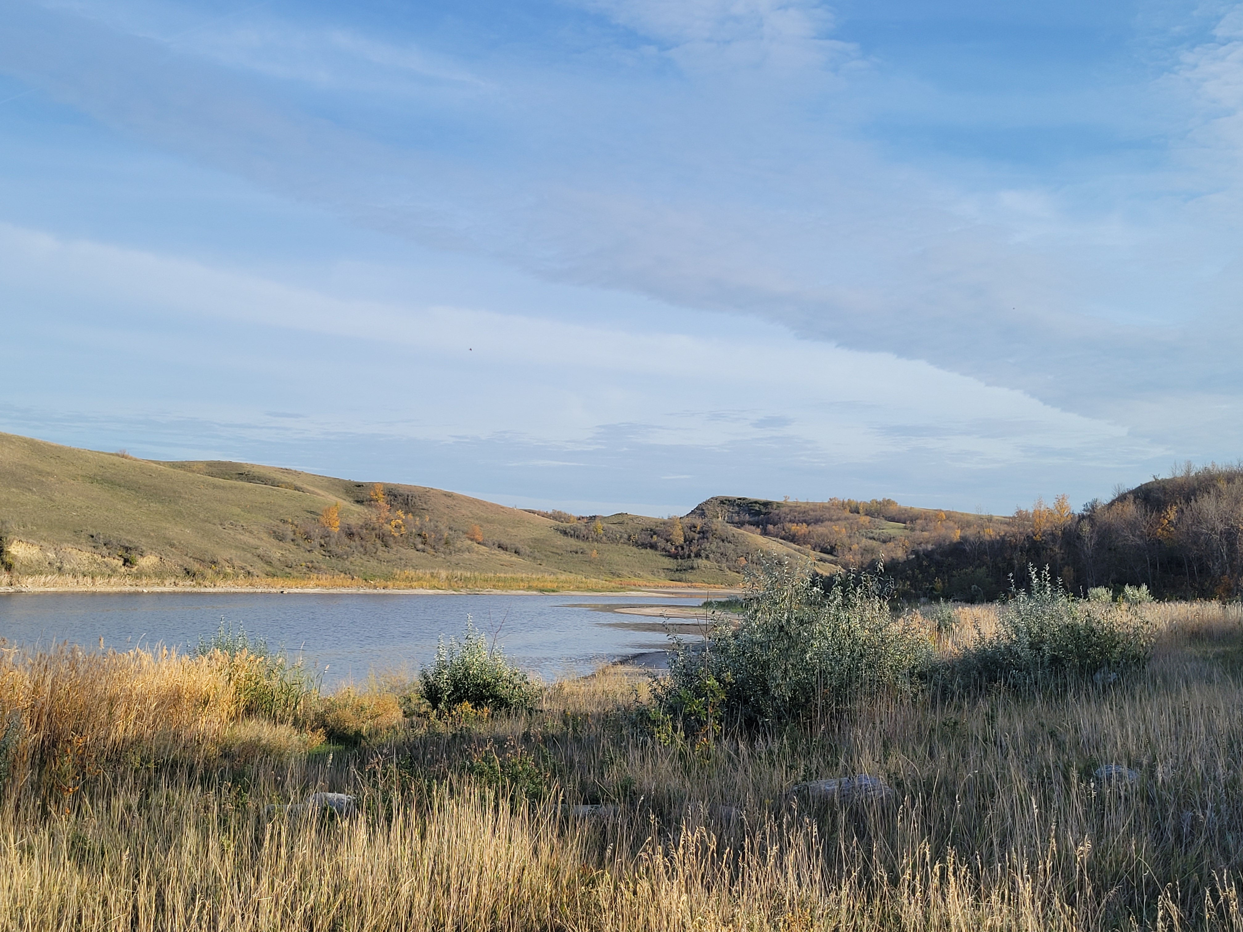
The Missouri River is the natural divide of two regions in North Dakota, the Drift Prairie, on the east side, and the Missouri Plateau, on the west side. The eastern part of the Missouri Plateau is called the Missouri Coteau (koe-TOE). “Coteau” is a French word, meaning “little hill.” The hills are made of the soil and rocks that were deposited when the last glacier melted.
The Hidatsa, Mandan and Arikara lived in earth and wood structure called “awahte” (Awa-adi in Hidatsa) or earthlodge.
The houses of the village-dwelling tribes on the upper Missouri usually were circular in shape, the larger houses averaging about thirty feet in diameter. Their design incorporated four center wooden pillars and an adjoining framework of posts and beams supporting numerous rafters and wall poles. Over these was laid a matting of willow and grass and an outer, insulating later of earth. A hole in the roof admitted some light and otherwise vented the smoke from a central firepit in the floor. An exterior, moveable screen shielded the vented from the wind and rain. The entrance to the interior was protected from the weather by a covered passageway. ... Description by David Hunt, Director, Stark Museum, Orange, Texas, USA
Mandan and Hidatsa people hosted Meriwether Lewis and William Clark and the men accompanying them over the winter of 1804–1805. Their many connections with people living up and down the Missouri River were incredibly important to the success of the Lewis and Clark Expedition.
Reconstructed earthen lodge, with wooden structure supporting it and wood-framed door opening to the outside. Modern building located nearby. Path and signs wind through grassy fields down to the river.
The Northern Plains National Heritage Area amplifies the nationally important heritage that flows from the Missouri River in central North Dakota. This includes the interconnected stories of explorers and settlers, tribal citizens, origins of various agrarian lifeways, and the expansion of the United States reflected within this lived-in landscape.
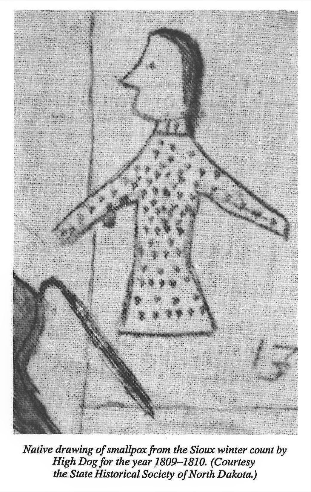
Stop #4 Smallpox arrives in the little village 1781
The North American smallpox epidemic from 1775–1782 overall death toll was estimated at 130,000; However, it is believed that many more Native Americans died than was accounted for. Lewis and Clark remarked in 1804 that the population was substantially less than reports before the epidemic. “Beginning in October, as the expedition made its way through present northern South Dakota, it passed numerous abandoned villages, composed of earth-lodge dwellings and cultivated fields. Some of the fields, although unattended, still had squash and corn growing in them. These had once been home to the mighty Arikara tribe. About thirty thousand persons strong in the year the United States won its independence, the tribe had been reduced by smallpox epidemics in the 1780’s to not much more than one-fifth that size. … What had been eighteen villages the previous year had been reduced to three by the time Lewis arrived.” (Ambrose, 178) Because of the smallpox epidemic in 1781, the Awatixa had to abandon Lower Hidatsa village. Some survivors moved to other surrounding villages, but most went north to Rock Village (near where the Garrison Dam is today). Wayside: Middens To imagine these people's daily lives, consider their trash. Molehill-like mounds two to four feet high near the village edge are middens or garbage heaps packed with broken pottery, bone tools, and flacked stone. Shattered buffalo bones are the most frequent objects archeologists have unearthed there. Though agrarian and river-based, the Awatixa (Ah-Wah-TEE-Khah) still depended on bison for meat, hides, and bone tools. Hunters brought back the butchered bison, and villagers crushed the large leg bones to extract marrow fat for grease. Photo 1: Bison hunt, from a painting by Karl Bodmer Photo 2 of Archeological cross-section of a midden. By focusing on everyday debris, you can begin to picture village activity yet miss the rich ceremonial life. For that you must rely on paintings and sketches by 19th-century artists George Catlin and Karl Bodmer. Catlin visited Awatixa Village, the next site along the trail.
What Happened to the Earthlodge Builders? "In the spring of 1834, ...the Sioux launched a massive attack on the villages at the month of the Knife River and burned Sakakawea and Amahami to the ground." (Stewart 1974:296) The Amahami Village was where the city of Stanton now stands. The Awatixa Hidatsa started another village known as Taylor Bluff south of Big Hidatsa. Being close to such a large village, like Big Hidatsa, would have helped provide protection from the Sioux. They lived in Taylor Bluff Village from 1834 until 1845. In 1845 all the Hidatsa vacated the Knife River area to settle, north, at Like-A-Fishhook Village. Like-A-Fishhook Village was inundated when the Garrison Dam was completed in 1950. In 1837 another smallpox epidemic came to the villages on the upper Missouri River. Again the loss of life was devastating to the tribes. Over 50% of the Hidatsa and Arikara surcumbed to smallpox. Over 90% of the Mandan population died leaving only 138 Mandan. Before they encountered Europeans, the Mandan population was estimated to have been 10,000 to 15,000 strong. Resilient, the Mandan, Hidatsa and Arikara have joined together to establish the Three Affiliated Tribes (MHA Nation) in Fort Berthold Indian Reservation. Their membership is 16,900 strong. To find out more, please, follow the links below. Why weren't they vaccinated? Four Bears Last Words History of Hidatsa: Post-1845 River-Centered Built so close to the river, Awatixa Village and other nearby sites suggest a pattern – a vital link between Hidatsa culture and the riverine environment. The Missouri River and its tributaries provided fish, fertile soil for crops, and a green world of berries and wild game below the semi-arid prairie. While the river made permanent settlement possible, it also brought inexorable change. Europeans and Americans used the Missouri River as their primary trade route. Mandans and Hidatsas began to be absorbed into the Euro-American economy, and were exposed to diseases from which they had no immunity. Below the text is a map of trade routes captioned as: Routes and centers of intertribal trade in 1805. Intertribal trade predated contact with Europeans. The map shows Mandan and Hidatsa traded with a Shoshoni trade center in Wyoming, Arikara trade center in South Dakota, a Dakota trade center and the Cheyanne, Arapahoe Comanche and Apache and Kiowa trade route. Painting of the Steamboat Yellow Stone on the Missouri River, from a painting by Karl Bodmer “People of the Willows” A bullboat was made from a freshly shinned buffalo hide stretched over a frame of willow branches. The craft could transport several hundred pounds of passengers or cargo, yet was light enough for one person to carry. Built and primarily navigated by the women of the village, bullboats floated dried meat downriver from buffalo hunts far to the west. Sketch of two women make a bullboat.
Knife River Indian Villages National Historic Site Visitor Center
The Visitor Center is located off Highway 37 just north of the city of Stanton, ND. The Visitor Center’s entrance is in the shape of a giant eagle welcoming visitors. Once inside, visitors can view the movie, tour the exhibits or shop in our bookstore. Outside and behind the Visitor Center is a reconstructed earthlodge (furnished with replica artifacts in the summer) and the beginning of one of the three trails located at the park.
Walk down the Village Trail (1.3 mi/2.1km) and see the remains of the Awatixa Xi'e Village (Lower Hidatsa Site) and Awatixa Village (Sakakawea Site). There is a loop at the second village site that includes a walk along the Knife River.
Tours
Count: 2
Earthlodge Tour
Walk into the earthlodge and walk back in time, to family life amongst the Hidatsa.
The Village Trail
The Village Trail is 1.3 miles round trip. The gravel trail is flat and wheelchair accessible. There are benches along the way. Leashed dogs are allowed. You will need water and bug spray. This tour starts in front of the earthlodge at the garden interpretive sign on the left.