Be advised that the NPS has issued alerts for this park.
Lighting and Maintaining Fires Information
Fires are permitted only in designated areas and under specific conditions. A fire may be ignited and maintained only by using fuel sources designed and commonly used for warmth or the preparation of food, such as charcoal briquettes or natural firewood. Lighting or maintaining a fire with other materials including, but not limited to, flammable liquids, garbage, fireworks, plastics, aerosol canisters, batteries, or other manufactured or synthetic materials, is prohibited.
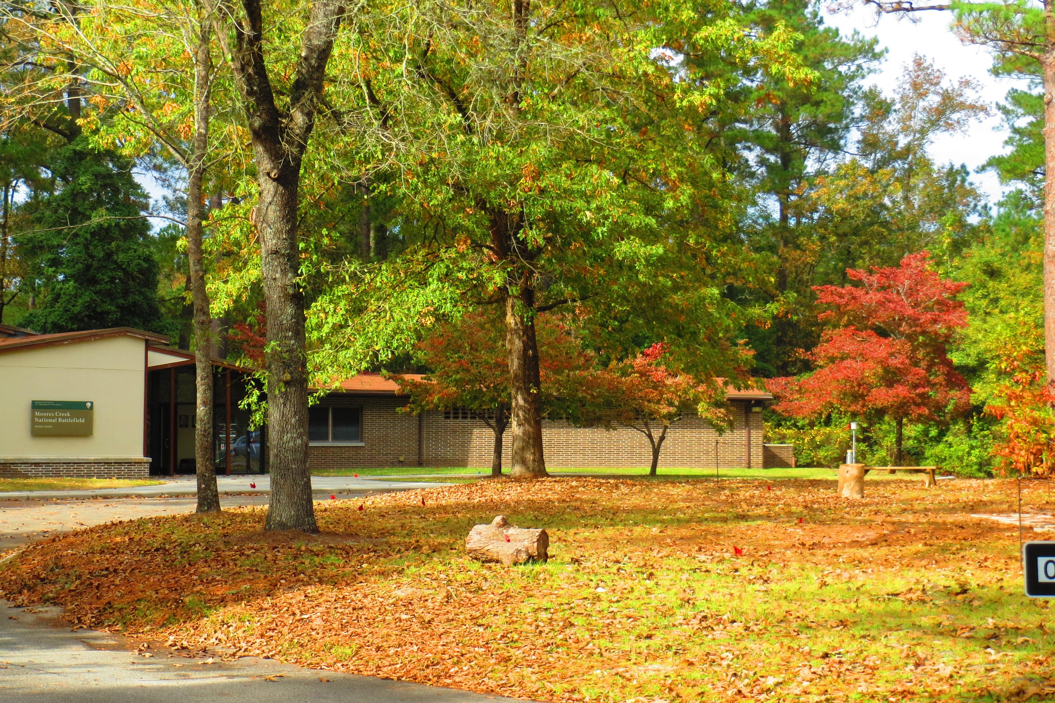
Moores Creek Visitor Center Open Tuesday-Saturday and Park Grounds Open Seven Days Per Week
The Moores Creek Visitor Center/Bookstore is open Tuesday to Saturday from 9 am until 5 pm. Park grounds are open seven days per week from 9 am until 5 pm.
Be Prepared for your Visit
Before hiking at Moores Creek, make sure to bring all your necessary medications, sunscreen, bottled water for hikes, loose fitting clothes for hiking, and any other items you may need.
In the early morning hours of February 27, 1776, Loyalist forces charged across a partially dismantled Moores Creek Bridge. Beyond the bridge, nearly 1,000 North Carolina Patriots waited quietly with cannons and muskets poised to fire. This battl...
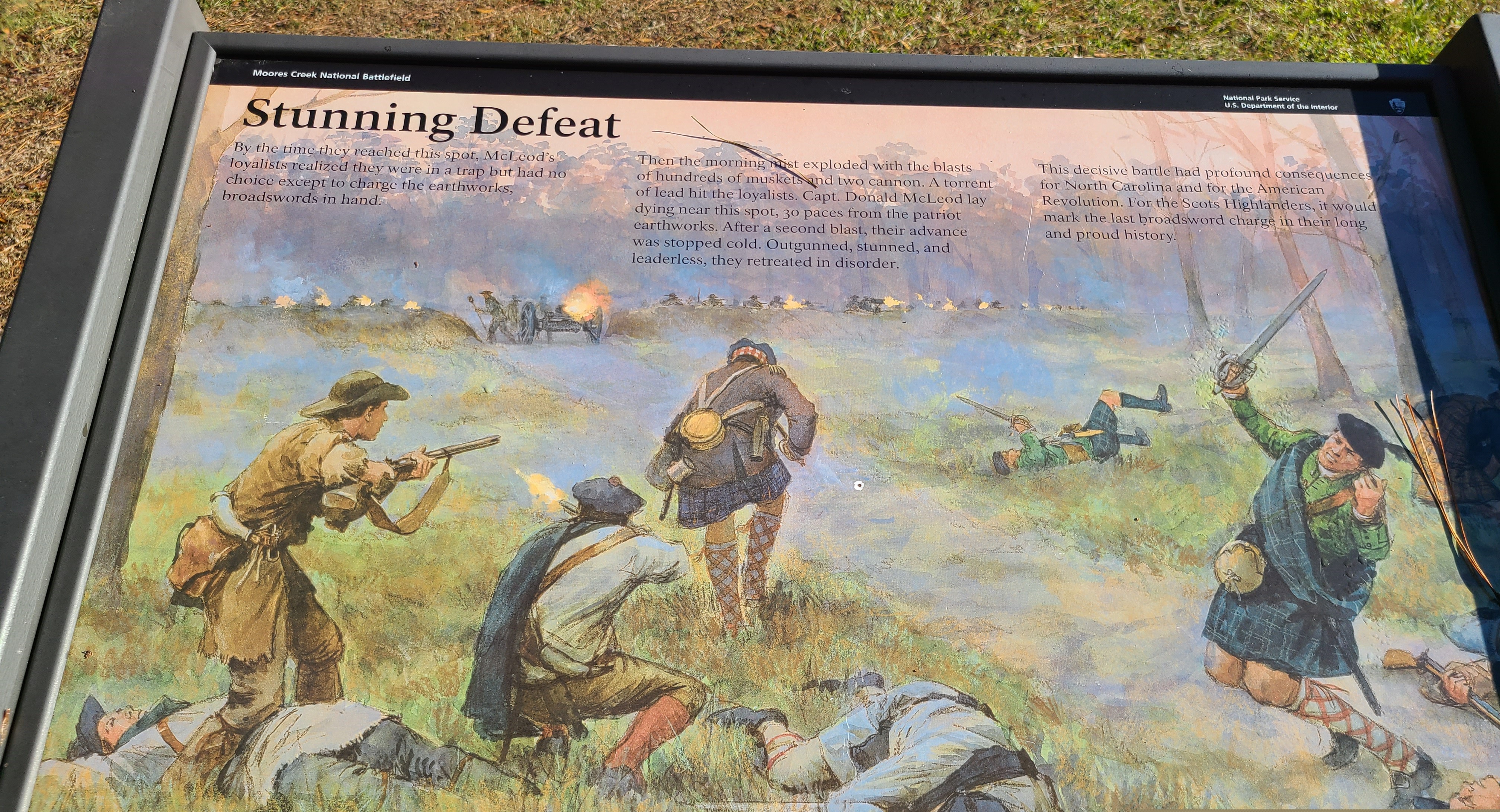
This panel sits beside the Black River Road as it curves from the bridge toward the Patriot's defensive earthworks. As you face the panel the road lies in front of you with the bridge to the left and the earthworks to the right. Behind you the paved History Trail continues. There are woods to the left. The space to the right in front of the earthworks is mown grass. The background of the panel has a color illustration showing 10 Highlanders charging towards the Patriot's earthworks in the background. Heads of men are visible looking over the earthworks as well as bright orange flashes of musket fire. A cannon sits where the road passes through the earthworks. IT also has flame coming from its muzzle. Half of the men in the foreground have already collapsed on the ground. One man in a kilt is in the act of falling. Only a couple of them have muskets -- the rest have swords. Text across the top reads, "By the time they reached this spot, McLeod's loyalists realized they were in a trap but had no choice except to charge the earthworks, broadswords in hand. Then the morning mist exploded with the blasts of hundreds of muskets and two cannon. A torrent of lead hit the loyalists. Captain Donald McLeod lay dying near this spot, 30 paces from the patriot earthworks. After a second blast, their advance was stopped cold. Outgunned, stunned, and leaderless, they retreated in disorder. This decisive battle had profound consequences for North Carolina and for the American Revolution. For the Scots Highlanders, it would mark the last broadsword charge in their long and proud history." Below the panel is a small sign indicating that this is stop number 8 on an audio tour which you may get from the Visitor Center.
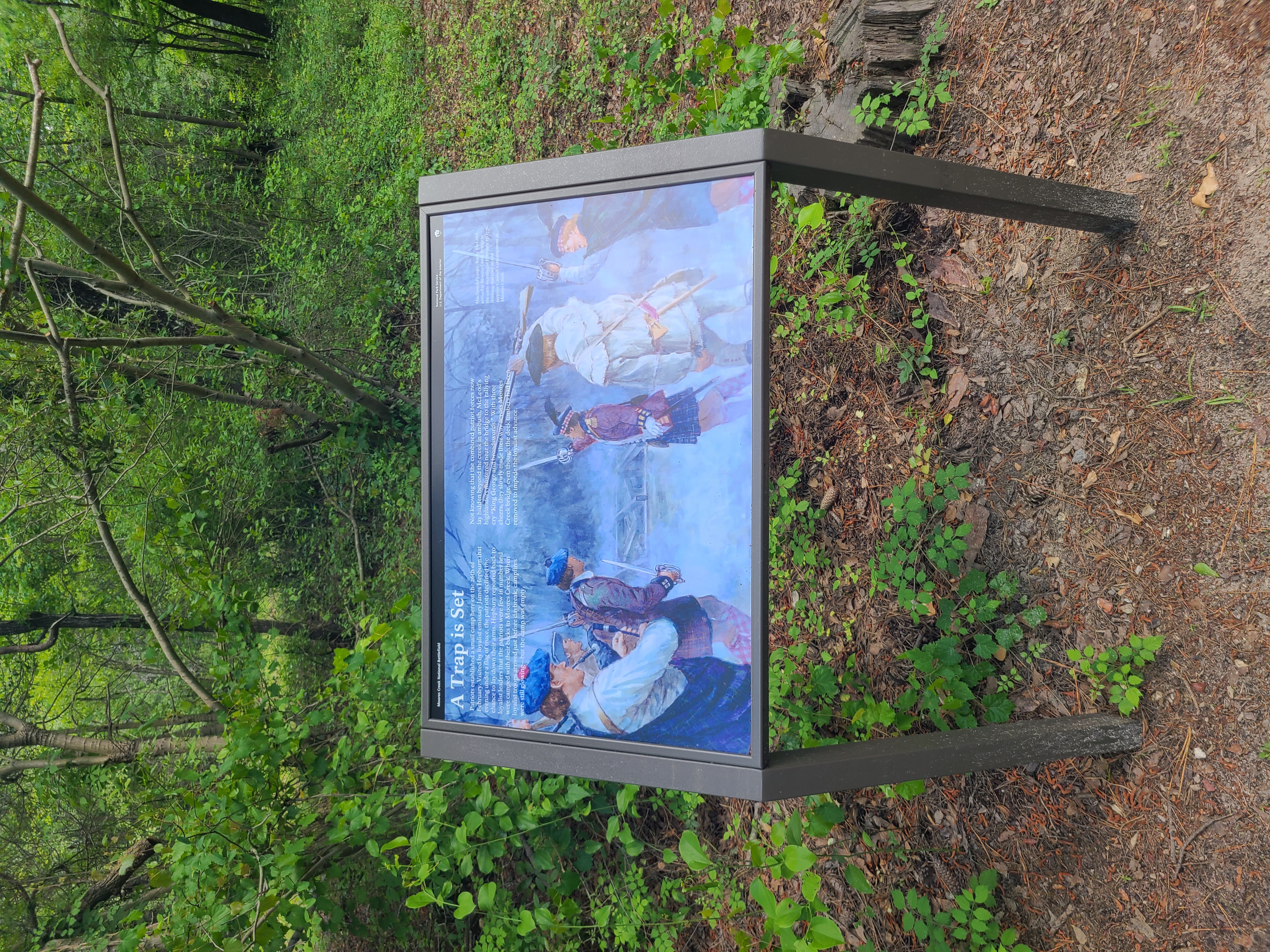
This panel sits at the intersection of the History Trail coming from the Visitor Center and the Black River Road. To the right the road leads a few yards to the bridge across Moores Creek. The ground gets progressively swampier as you near the bridge with thick woods on either side. Behind the Black River Road continues on to the park boundary. Directly to the left is the paved path leading back to the Visitor Center. The background of the panel shows seven men facing away from us towards the bare beams of the bridge. Several of the men wear kilts. One wears pants and a long fringed jacket. Most are waving swords as they move towards the bridge. At left one man is playing the bagpipes. Text across the top reads, "Patriots established a small camp here on the 26th of February. Visited by loyalist emissary James Hepburn that evening under a flag of truce, the patriots declined the chance to lay down their arms. Hepburn reported back to loyalist leaders that the patriots were few in number and were camped with their backs to Moores Creek. When loyalist troops arrived just before daybreak, campfires were still glowing - but the camp was empty. Not knowing that the combined patriot forces now lay hidden beyond the creek in ambush, McLeod's highlanders mustered near the bridge to the rallying cry "King George and broadswords." With three cheers, they slowly made their way across Moores Creek bridge, even though the deck timbers had been removed to impede the loyalist advance." At upper right more text reads, "MacDonald's army, led by McLeod, arrived at Moores Creek Bridge in the early morning of February 27, 1776, thinking that they would surprise Caswell's encampment at Moores Creek." Below the panel is a small sign indicating that this is stop number 6 on an audio tour which you may get from the Visitor Center.
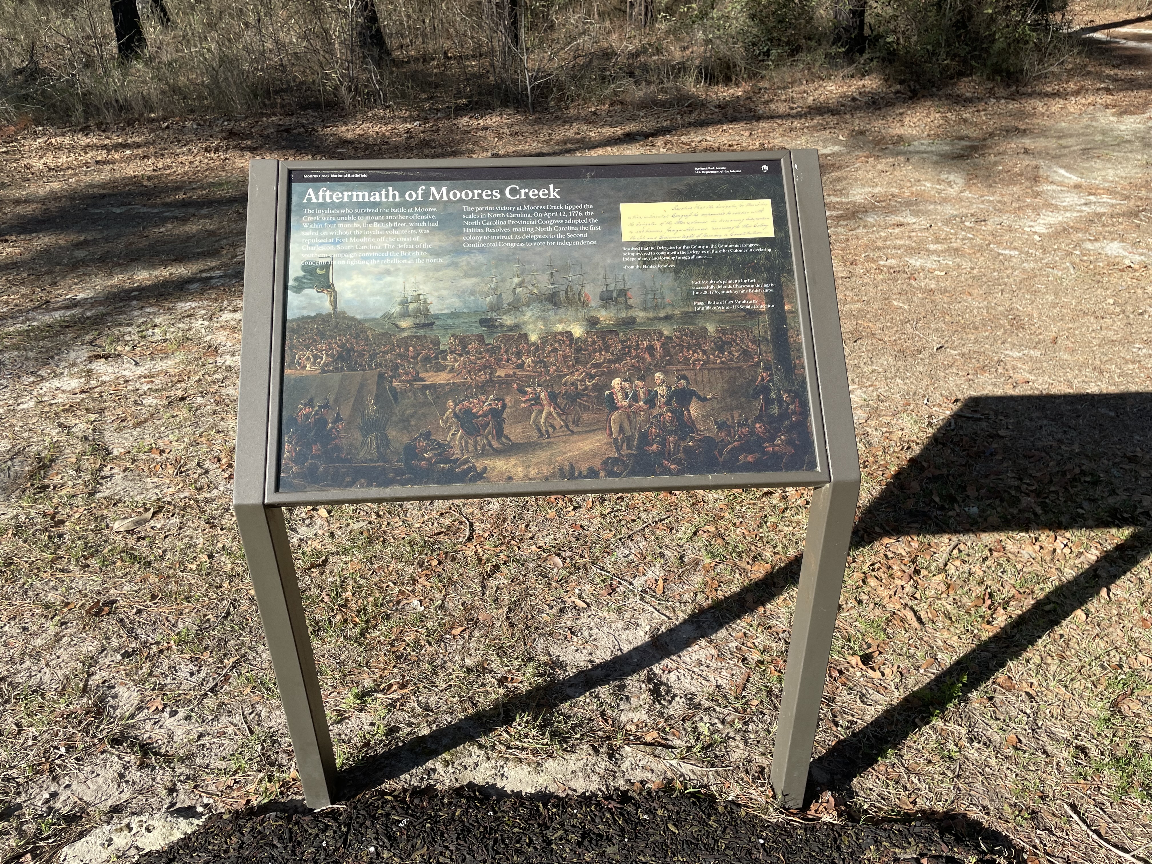
This panel sits along the paved path facing the woods. You are now outside of the earthworks. To your right the path cuts through the earthworks and passes the cannon. A few short yards in the direction is a bench. On this side of the bench is a small post with an audio station. Push buttons on the front activate the different audio stories. There are three buttons down the left side and three down the right. From top to bottom on the left the audio segments are titled "Moores Creek," "Earthworks," and "Commemoration." The ones down the right correspond to "Longleaf Pine Trees, " The Loyalists Charge," and "En Español." The background of this panel features an image of a painting - Battle of Fort Moultrie by John Blake White from the US Senate Collection. In the background is the harbor with a number of three-masted ships on the water, puffs of smoke rising. Lining the edge of the harbor is a series of square defensive structures with cannon ports between them. That area is filled with soldiers. In the foreground, separated from the men and the cannon by a tall wooden wall, are groups of officers in blue jackets with red trim, white pants, and knee-high boots. A dark canvas tent is to the left of them. In the lower right corner more men huddle around those who are wounded. The caption reads, "Fort Moultrie's palmetto log fort successfully defends Charleston during the June 28, 1776, attack by nine British ships." Text across the top reads, "The loyalists who survived the battle at Moores Creek were unable to mount another offensive. Within four months, the British fleet, which had sailed on without the loyalist volunteers, was repulsed at Fort Moultrie off the coast of Charleston, South Carolina. The defeat of the southern campaign convinced the British to concentrate on fighting the rebellion in the north. The patriot victory at Moores Creek tipped the scales in North Carolina. On April 12, 1776, the North Carolina Provincial Congress adopted the Halifax Resolves, making North Carolina the first colony to instruct its delegates to the Second Continental Congress to vote for independence." In the upper right corner is an image of a small section of a handwritten document, yellowed with age. Below the image are transcribed several lines from the Halifax Resolves which read, "Resolved that the Delegates for this Colony in the Continental Congress be impowered to concur with the Delegates of the other Colonies in declaring Independency and forming foreign alliances." End of Description.
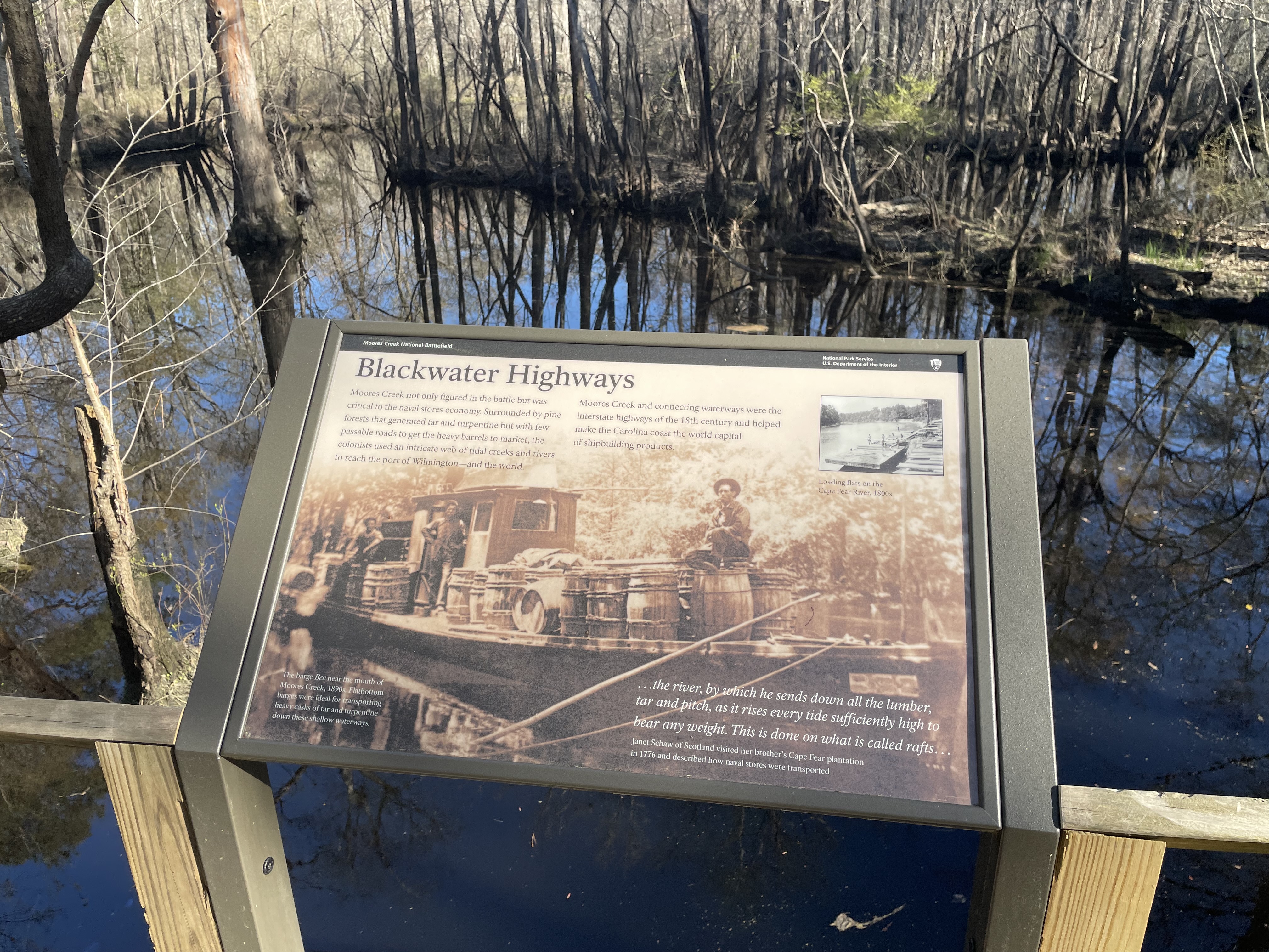
This panel sits on the railing on the right side of the boardwalk as you come from the Visitor Center. This end of the boardwalk crosses the main channel of the creek. The water is dark and reflects the trees and bushes that line its banks. Some of the trees lean over the water and many branches extend over creating a tunnel effect. Farther along the boardwalk to your left as you face the panel is a bench. The background of the panel has a historic photograph of a long boat with a small cabin in the middle moored on the creek. The rest of the deck is crowded with large wooden barrel. Three men wearing overalls and wide-brimmed hats stand amid the barrels. The caption at lower left reads, "The barge Bee near the mouth of Moores Creek, 1890s. Flatbottom barges were ideal for transporting heavy casks of tar and turpentine, down these shallow waterways." At bottom right on the panel is a quote from Janet Schaw of Scotland who visited her brother's Cape Fear plantation in 1776 and described how navel stores were transported. The quote reads, "The river, by which he sends down all the lumber, tar and pitch, as it rises every tide sufficiently high to bear any weight. This is done on what is called rafts." At upper left text reads, "Moores Creek not only figured in the battle but was critical to the naval stores economy. Surrounded by pine forests that generated tar and turpentine but with few passable roads to get the heavy barrels to market, the colonists used an intricate web of tidal creeks and rivers to reach the port of Wilmington—and the world. Moores Creek and connecting waterways were the interstate highways of the 18th century and helped make the Carolina coast the world capital of shipbuilding products." At upper right is a small photograph of a long flat boat along a shoreline. A half dozen men are loading long pieces of lumber onto it. The caption reads, "Loading flats on the Cape Fear River, 1800s." End of Description.
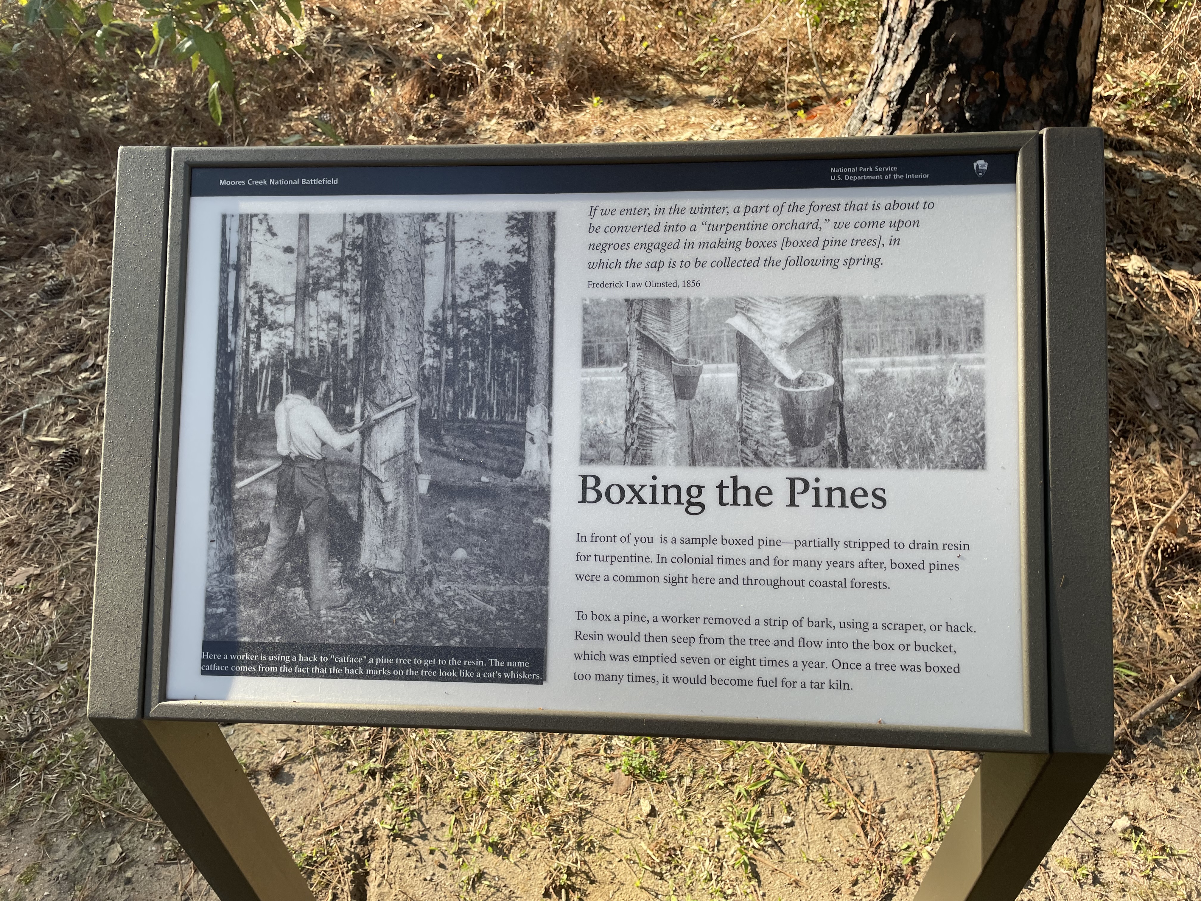
This panel sits on the right side of the Tar Heel Trail in the middle of open pine woods with low undergrowth. Pine trees with their distinctive rough bark are all around. One tree trunk a few feet to the right of the panel has been carved to illustrate the procedure described on the panel. Feel free to touch! On the left side of the panel is a black and white photograph of a Black man using a long-handled axe-like tool to remove a V-shaped section of bark from a pine tree. Attached to the tree near the bottom of the carved section are two small pots. The caption reads, "Here a worker is using a hack to "catface" a pine tree to get to the resin. The name catface comes from the fact that the hack marks on the tree look like a cat's whiskers." At upper right on the panel is a quote from Frederick Law Olmsted, 1856, which reads, "If we enter, in the winter, a part of the forest that is about to be converted into a "turpentine orchard," we come upon negroes engaged in making boxes [boxed pine trees], in which the sap is to be collected the following spring." Below the quote is a photograph with a close view of a boxed section of tree trunk with pots hanging below to collect the sap. Text at the bottom right reads, "In front of you is a sample boxed pine-partially stripped to drain resin for turpentine. In colonial times and for many years after, boxed pines were a common sight here and throughout coastal forests. To box a pine, a worker removed a strip of bark, using a scraper, or hack. Resin would then seep from the tree and flow into the box or bucket, which was emptied seven or eight times a year. Once a tree was boxed too many times, it would become fuel for a tar kiln." End of Description.
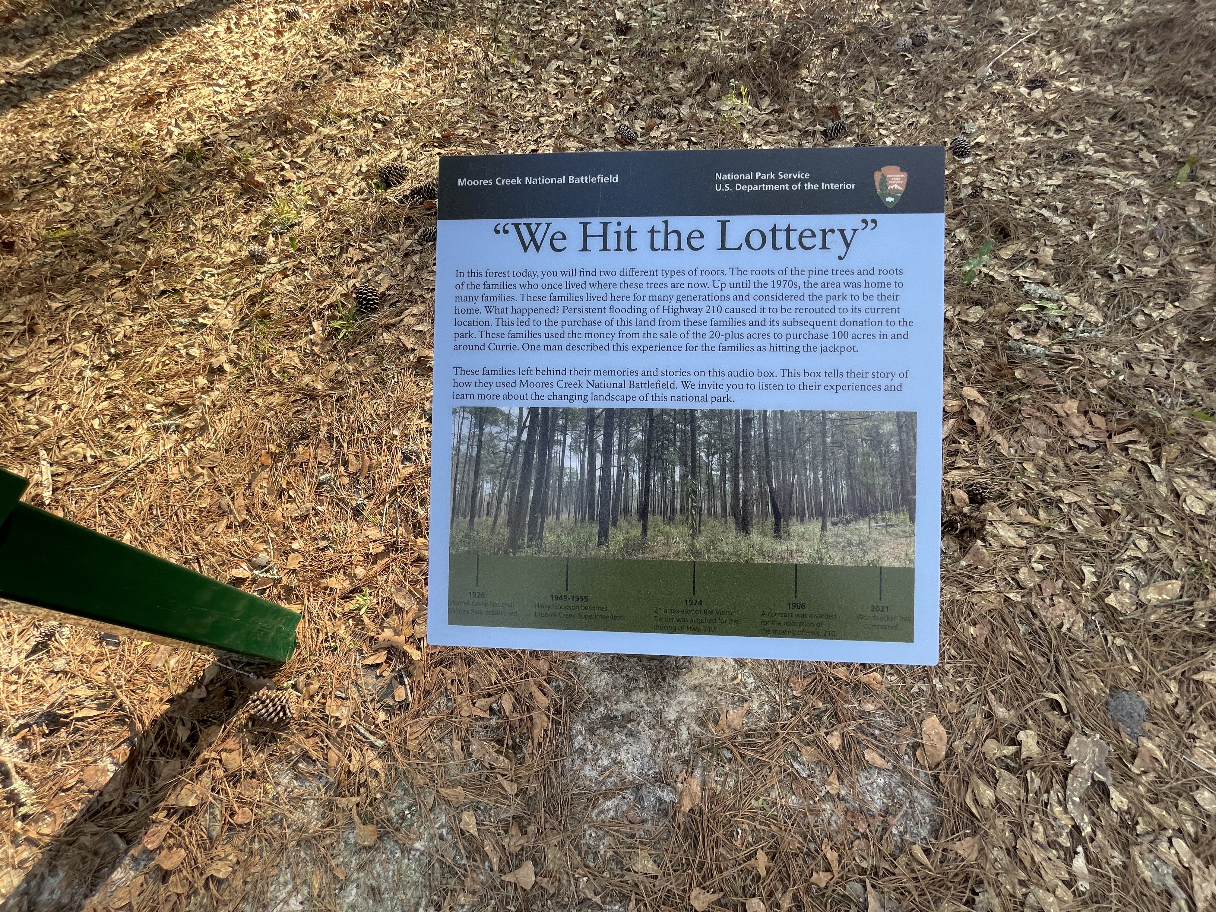
This small panel sits on the side of the wide sandy path in open pine woods. To the left of the panel is an audio station, then a bench, and then a trash can. The audio station has four buttons which activate the different audio stories, two buttons down the left side and two down the right. From top to bottom on the left the audio segments are titled "This Was Our Park," and "World War II in the Park." The ones down the right correspond to "Water and a Wheelbarrow," and "Selling Family Land/Rerouting 210." Text at the top of the panel reads, "In this forest today, you will find two different types of roots -- the roots of the pine trees and roots of the families who once lived where these trees are now. Up until the 1970s, the area was home to many families. These families lived here for many generations and considered the park to be their home. What happened? Persistent flooding of Highway 210 caused it to be rerouted to its current location. This led to the purchase of this land from these families and its subsequent donation to the park. These families used the money from the sale of the 20-plus acres to purchase 100 acres in and around Currie. One man described this experience for the families as hitting the jackpot. These families left behind their memories and stories on this audio box. This box tells their story of how they used Moores Creek National Battlefield. We invite you to listen to their experiences and learn more about the changing landscape of this national park." Across the middle of the panel is a photograph of the pine woods you are now standing in. Across the bottom is a timeline of events. From left to right the first entry is 1926, Moores Creek National Military Park established. Next is 1948 to 1955, Harry Goodson becomes Moores Creek Superintendent. Next is 1974, 21 acres east of the Visitor Center was acquired for the moving of Highway 210. Next is 1986, a contract was awarded for the relocation of Highway 210. The last entry is 2021, Woodpecker Trail completed. End of Description.
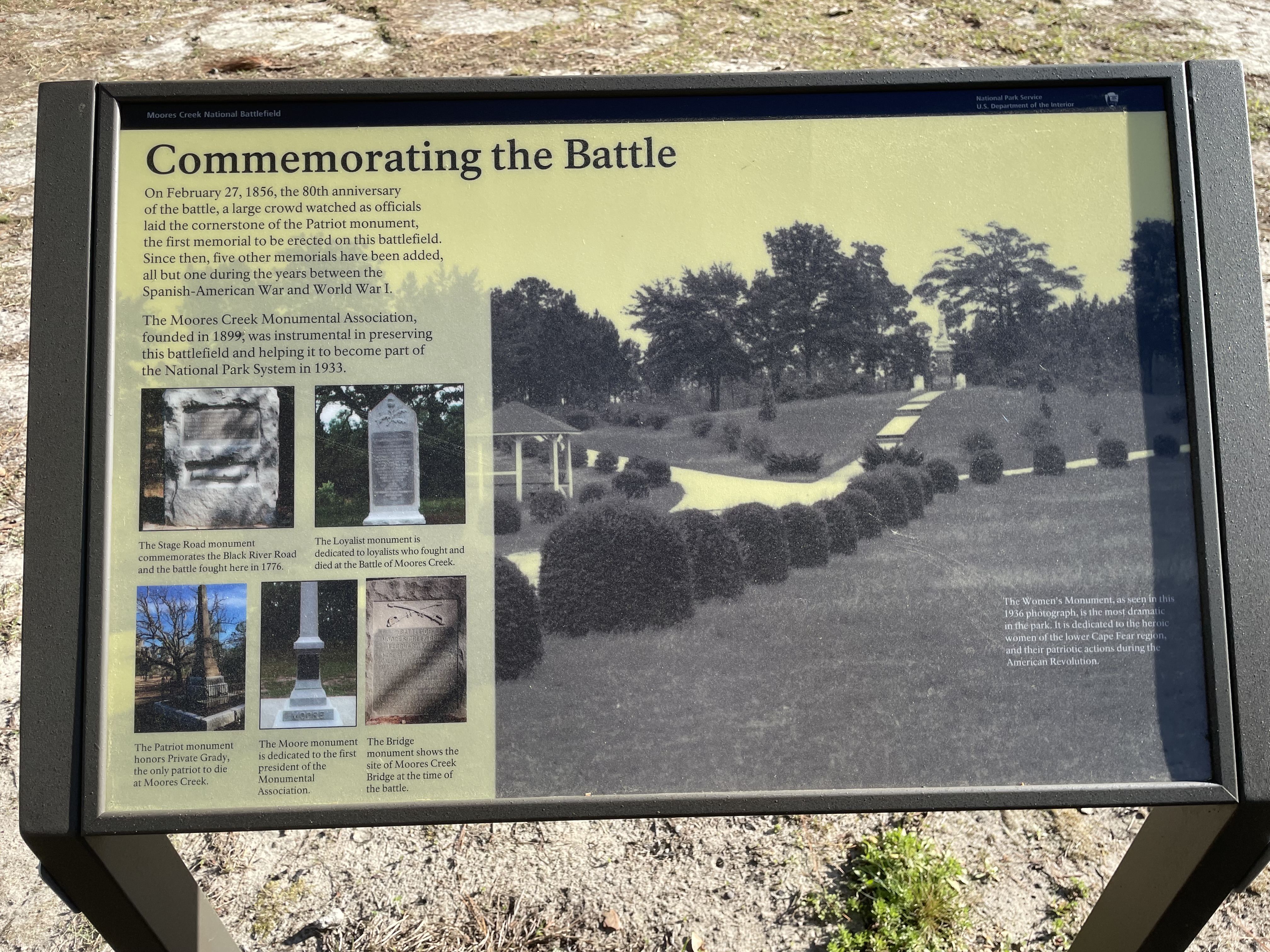
This panel sits along the paved path with the encircling earthworks back to the left. To the right three stone monuments are spaced out along the path. Text at upper left on the panel reads, "On February 27, 1856, the 80th anniversary of the battle, a large crowd watched as officials laid the cornerstone of the Patriot monument, the first memorial to be erected on this battlefield. Since then, five other memorials have been added, all but one during the years between the Spanish-American War and World War I. The Moores Creek Monumental Association, founded in 1899, was instrumental in preserving this battlefield and helping it to become part of the National Park System in 1933." Below the text are photographs of five of the monuments. At upper left is the Stage Road monument, a rectangular granite block with a block of text near the top and a carved cannon lower down. The caption reads, "The Stage Road monument commemorates the Black River Road and the battle fought here in 1776." To the right is the Loyalist monument shaped like a rectangle with a triangle on top. At top is a carving of a thistle with text below. The caption reads, "The Loyalist monument is dedicated to loyalists who fought and died at the Battle of Moores Creek." At the bottom left is a photograph of a tall obelisk of reddish-tan stone surrounded by an iron fence. There is engraved text on all sides. The caption reads, "The Patriot monument honors Private Grady, the only patriot to die at Moores Creek." The middle photo shows a white obelisk with the word "Moore" carved at the base. The caption reads, "The Moore monument is dedicated to the first president of the Monumental Association." The fifth photo shows a red granite rectangle with crossed swords at the top and text below. The caption reads, "The Bridge monument shows the site of Moores Creek Bridge at the time of the battle." The right side of the panel is filled with a historic photograph looking down a paved path edged with shrubbery towards a tall monument with a statue of a woman on top. The caption reads, "The Women's Monument, as seen in this 1936 photograph, is the most dramatic in the park. It is dedicated to the heroic women of the lower Cape Fear region, and their patriotic actions during the American Revolution." Below the panel is a small sign indicating that this includes stop number 10 and 11 on an audio tour which you may get from the Visitor Center. End of Description.
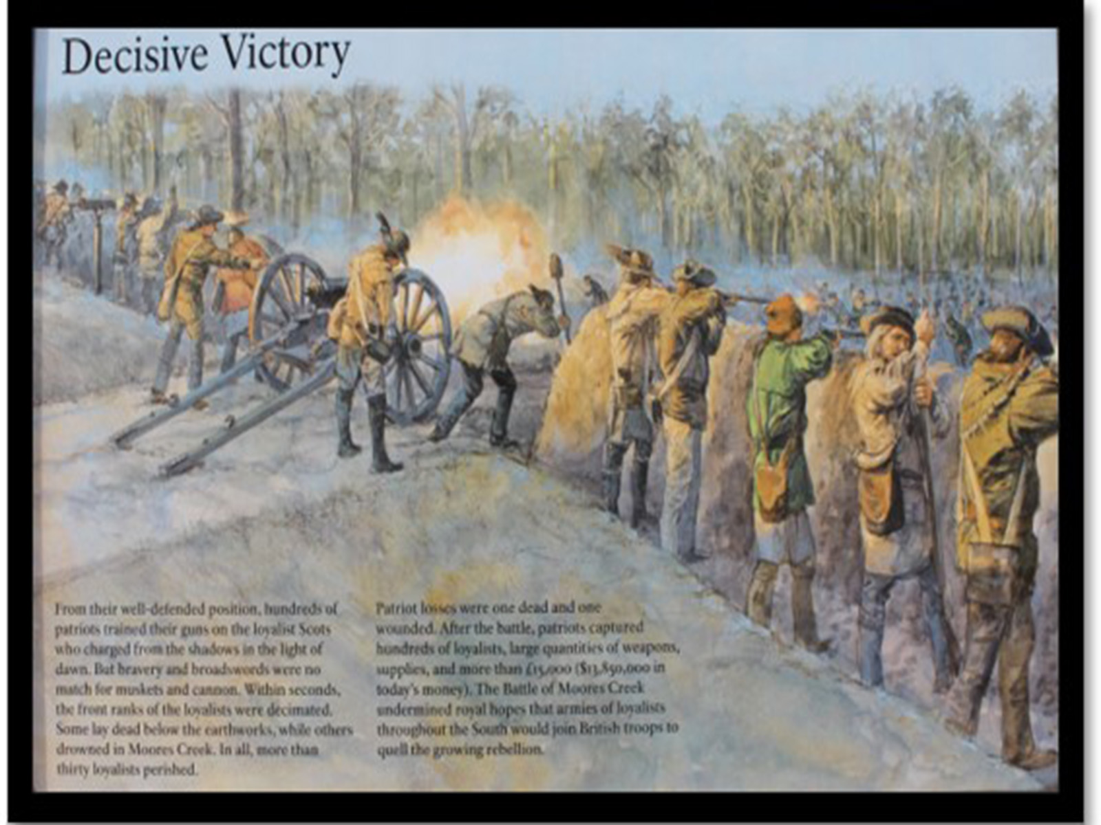
This panel sits along the paved path looking back towards the road. The bridge is to the left, hidden by the woods. The paved path to the left cuts through the remains of the earthworks which cross in front of the panel. Another path extends to the right, behind the earthworks, back to the road. Down that path is a bench. Also in that direction just behind the earthworks is a swivel gun mounted on a post. To your left the History Trail continues along the paved path. In that direction is a cannon, which you are free to touch. A sign does ask that you not climb on the cannon however. A small sign by the cannon indicates that it is stop number 9 on an audio tour which you may get from the Visitor Center. The background of the panel has a color illustration showing the battle from behind the Patriot's line. Men stand behind the line of shoulder-high earthworks firing their muskets at the charging Highlanders. In the middle several men are firing the cannon. The Patriots wear a variety of styles of pants and jackets, as well as hats. Text across the bottom reads, "From their well-defended position, hundreds of patriots trained their guns on the loyalist Scots who charged from the shadows in the light of dawn. But bravery and broadswords were no match for muskets and cannon. Within seconds, the front ranks of the loyalists were decimated. Some lay dead below the earthworks, while others drowned in Moores Creek. In all, more than thirty loyalists perished. Patriot losses were one dead and one wounded. After the battle, patriots captured hundreds of loyalists, large quantities of weapons, supplies, and more than £15,000 ($13,850,000 in today's money). The Battle of Moores Creek undermined royal hopes that armies of loyalists throughout the South would join British troops to quell the growing rebellion." End of Description.
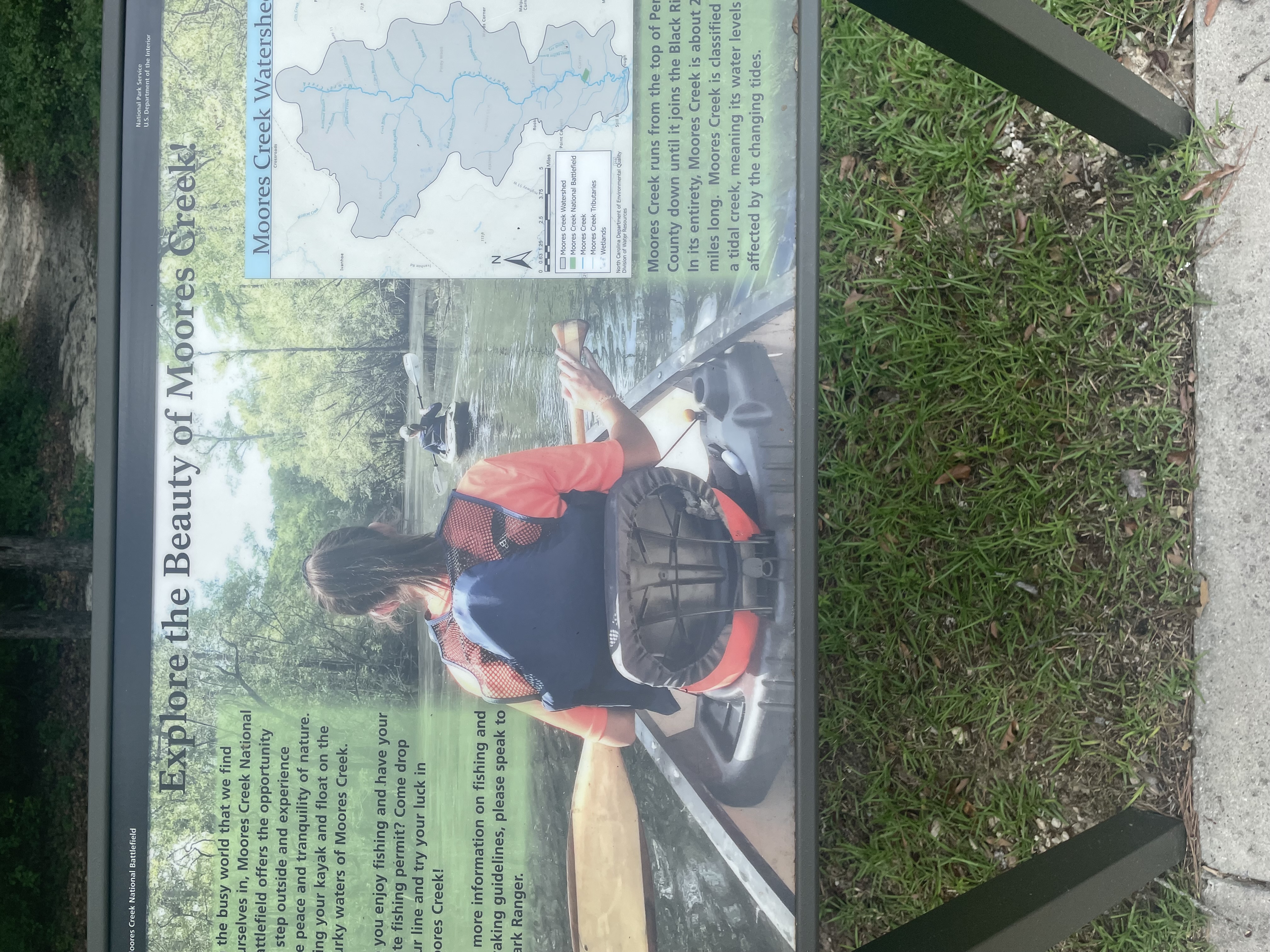
Here at the end of the parking lot are three graphic panels. On the other side of the panels a sandy path leads through the woods heading down to the creek. The sidewalk curves around behind you to the left towards Patriot's Hall, passing the picnic area on the way. This panel is the one on the left. The background has a photograph with a view looking down the still waters of the creek. In the foreground we see the back of a young women, her brown hair pulled back in a ponytail, holding a paddle as she sits in the front of the canoe. Ahead farther down the creek is a kayak with another young woman. Text at upper right reads, " In the busy world that we find ourselves in, Moores Creek National Battlefield offers the opportunity to step outside and experience the peace and tranquility of nature. Bring your kayak and float on the murky waters of Moores Creek. Do you enjoy fishing and have your state fishing permit? Come drop your line and try your luck in Moores Creek! For more information on fishing and kayaking guidelines, please speak to a Park Ranger." At right is a map of the Moores Creek watershed. The gray area is roughly shape like an oak leaf -- wide at the top and narrow at the bottom -- with the creek running the length from north to south. The park is a small green rectangle near the bottom of the watershed area. Text below the map reads, "Moores Creek runs from the top of Pender County down until it joins the Black River. In its entirety, Moores Creek is about 22 miles long. Moores Creek is classified as a tidal creek, meaning its water levels are affected by the changing tides." To the right of this panel is a small one titled "Let's Go Fishin' with Track and Kip." It has a cartoon figure of a beagle sitting on a bank beside a creek. He holds a fishing rod as a large fish leaps out of the water, hook in mouth. A balloon by the dog reads, "Hi, I'm Track." At upper right is a dragonfly with a balloon reading "I'm Kip." Text at upper right reads, " Kids in Parks has created a network of family-friendly outdoor adventures called TRACK Trails. This is one of our Fishing Trails. Each TRACK Trail features self-guided brochures and signs that turn your visit into a fun and exciting outdoor experience. Best of all, you can earn PRIZES for tracking your adventures on our website!" "Grab a brochure below!" The brochures are located below the larger panel to the right. End of Description.
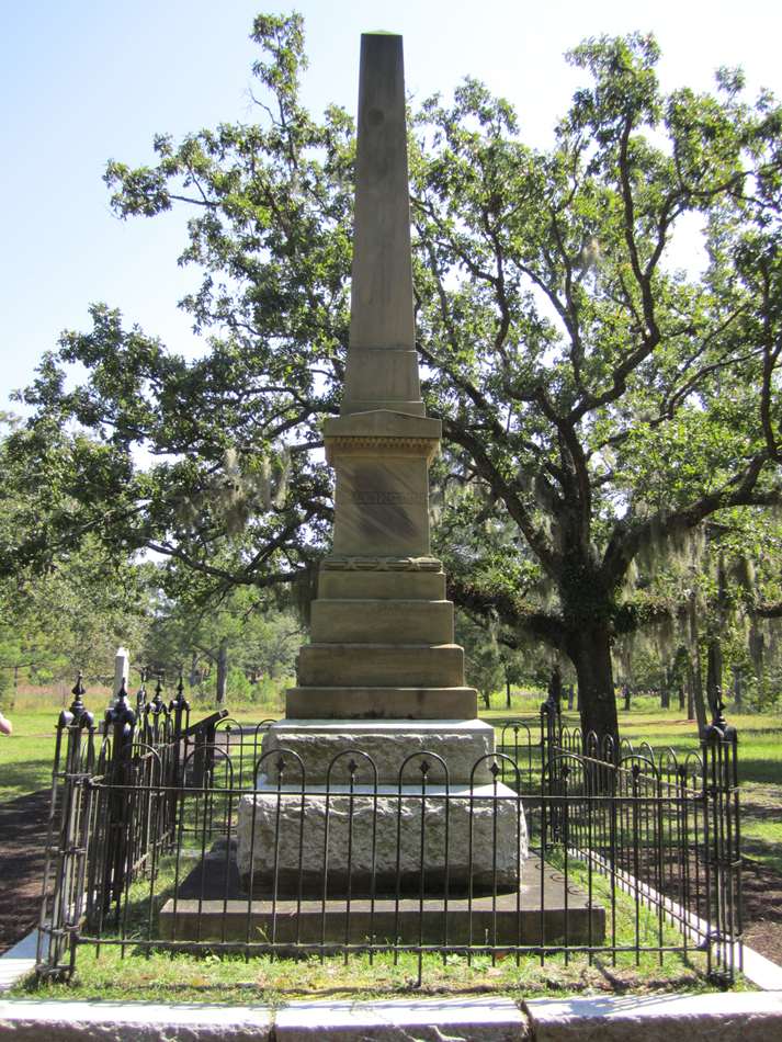
This tall stone obelisk sits to one side of the History Trail. To the right is the battlefield. To the left the trail winds up a slight slope past more monuments. This monument is of smoothly carved reddish tan stone sitting on a gray granite base. It is protected by a wrought iron fence. Carved text on the front reads, "Here lie the remains of Private John Grady of Duplin County who fell bravely fighting for his country. The first martyr in the cause of freedom in North Carolina and the only Whig killed in this battle." Carved on the right side of the monument is the word "Lillington" and on the left side is "Caswell." Carved text on the back reads, "In commemoration of the Battle of Moores Creek Bridge fought here 27th February 1776. The first victory gained by the American arms in the War of the Revolution." End of Description.
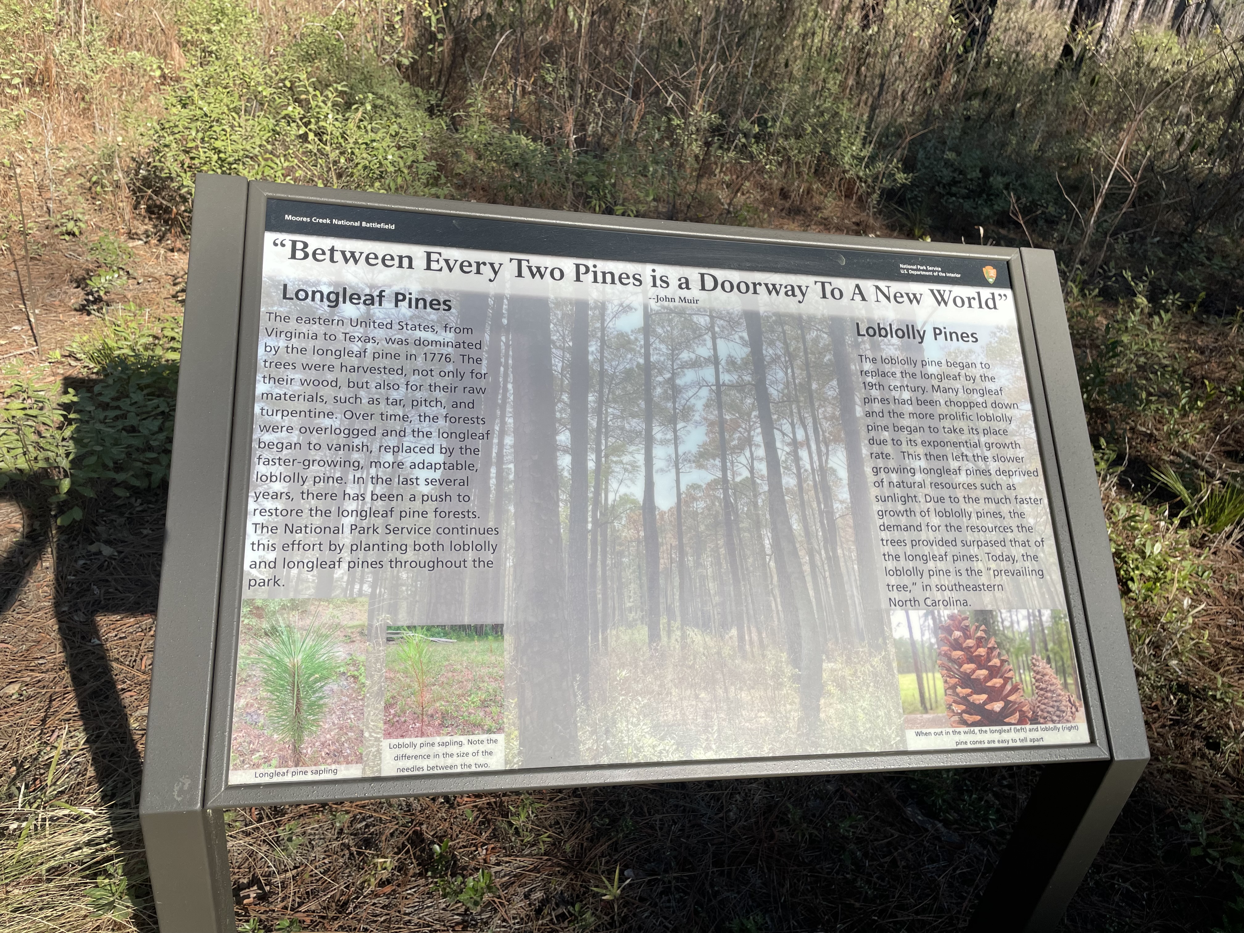
This small panel sits on the side of the wide sandy path in open pine woods with low undergrowth. Many of the pine trees have blackened bark partway up their trunks. Behind you can be heard some traffic along Highway 210 which is not far away. Across the top of the panel is a quote from John Muir which reads, "Between Every Two Pines is a Doorway to a New World." The background of the panel has a ghosted photograph of the pine woods you are standing in. Text down the left side of the panel reads, "Longleaf Pines. The eastern United States, from Virginia to Texas, was dominated by the longleaf pine in 1776. The trees were harvested, not only for their wood, but also for their raw materials, such as tar, pitch, and turpentine. Over time, the forests were over-logged and the longleaf began to vanish, replaced by the faster-growing, more adaptable, loblolly pine. In the last several years, there has been a push to restore the longleaf pine forests. The National Park Service continues this effort by planting both loblolly and longleaf pines throughout the park." Below the text are photographs of saplings from the two kinds of pine. At left is a longleaf sapling. The thick stem is surrounded with many dark green needles. The ones near the top are very long. To the right is a photo of a loblolly sapling. Its stem is thinner, splitting into two branches at top. The needles along each branch are shorter than the other sapling. The caption reads, " Note the difference in the size of the needles between the two." Down the right side of the panel more text reads, "Loblolly Pines. The loblolly pine began to replace the longleaf by the 19th century. Many longleaf pines had been chopped down and the more prolific loblolly pine began to take its place due to its exponential growth rate. This then left the slower growing longleaf pines deprived of natural resources such as sunlight. Due to the much faster growth of loblolly pines, the demand for the resources the trees provided surpassed that of the longleaf pines. Today, the loblolly pine is the "prevailing tree," in southeastern North Carolina." Below the text is a photograph of a pinecone from each type of pine. The one on the left is much larger and has open spaces between the scales. The one on the right is shorter, thinner, and has tightly closed scales. The caption reads, " When out in the wild, the longleaf (left) and loblolly (right) pinecones are easy to tell apart." End of Description.
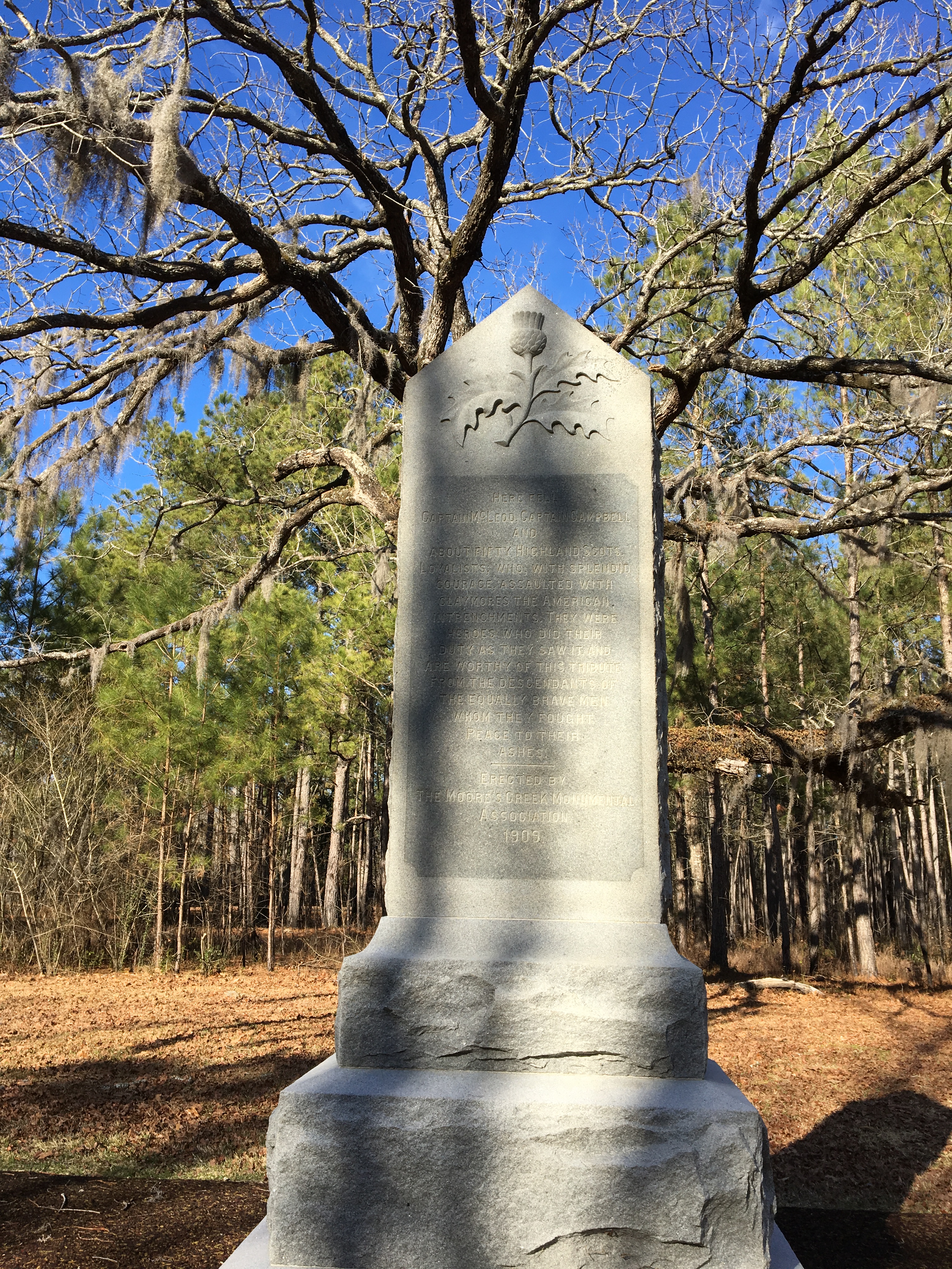
This tall monument sits on one side of the History Trail. To the right are more monuments. To the left is the Patriot monument and the site of the battle. The monument is a vertical rectangle with a peak on the top, sitting on a gray granite base. At the top is a relief carving of a thistle. Below that carved text reads, "Here fell Captain McLeod, Captain Campbell, and about fifty Highland Scots Loyalists: who, with splendid courage, assaulted with claymores the American intrenchments. They were heroes who did their duty as they saw it and are worthy of this tribute from the descendants of the equally brave men whom they fought. Peace to their ashes. Erected by the Moores Creek Monumental Association, 1909." Feel free to touch! End of Description.
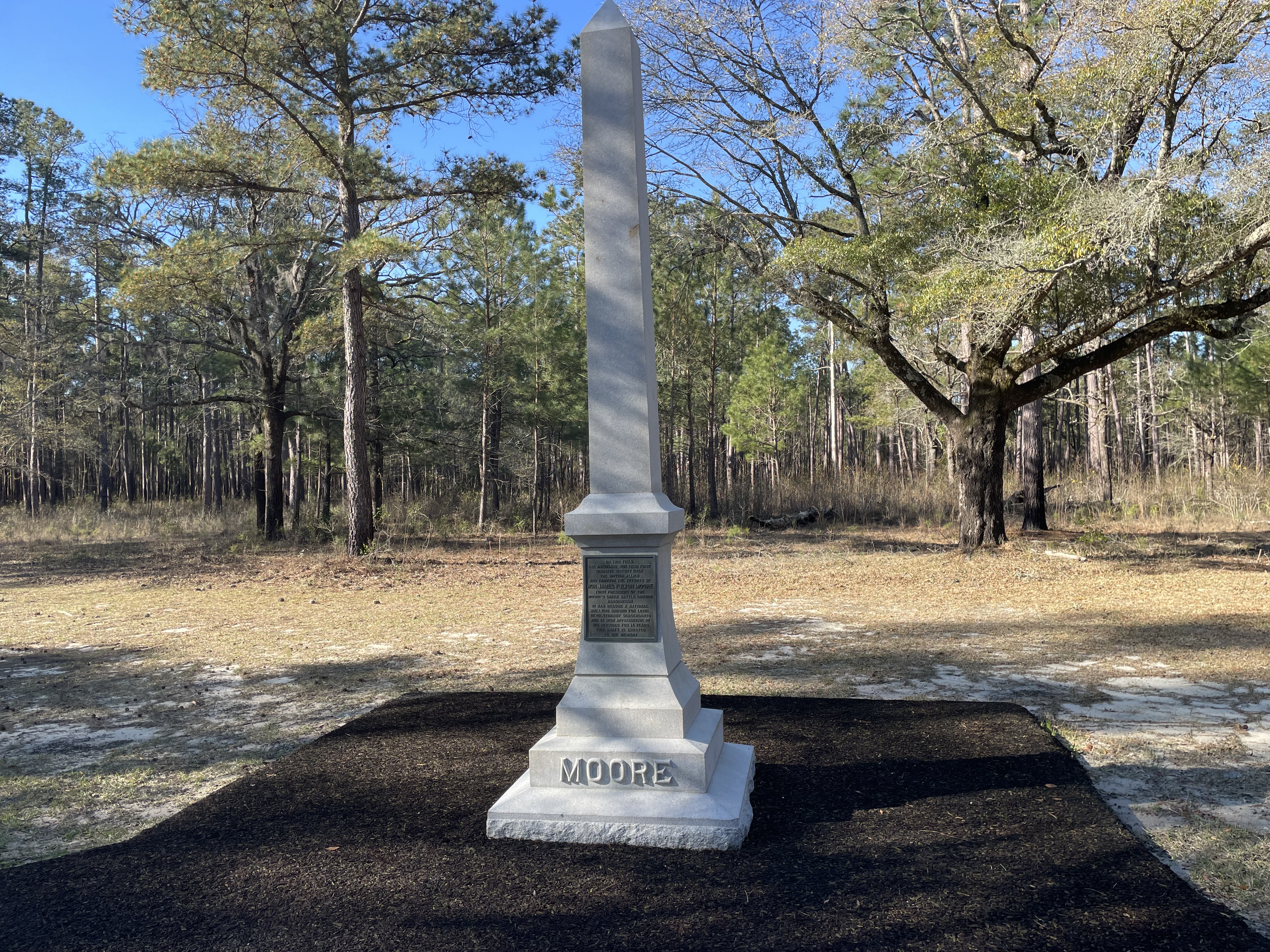
This tall monument sits on one side of the History Trail. Farther along the path to the left is a bench. The monument is a tall obelisk of pale gray stone. Carved at the base is the word "Moore." A bronze plaque on front has engraved text that reads, "On this field the Americans won their first decisive victory over the British allies and through the efforts of Honorable James Fulton Moore, first president of the Moore's Creek Battle Ground Association, it has become a national rallying ground for loyal revolutionary descendants and in high appreciation of his services for 14 years this shaft is erected to his memory." On the back of the monument carved text reads, "James Fulton Moore, February 14, 1852. July 11, 1912." Feel free to touch! End of Description.
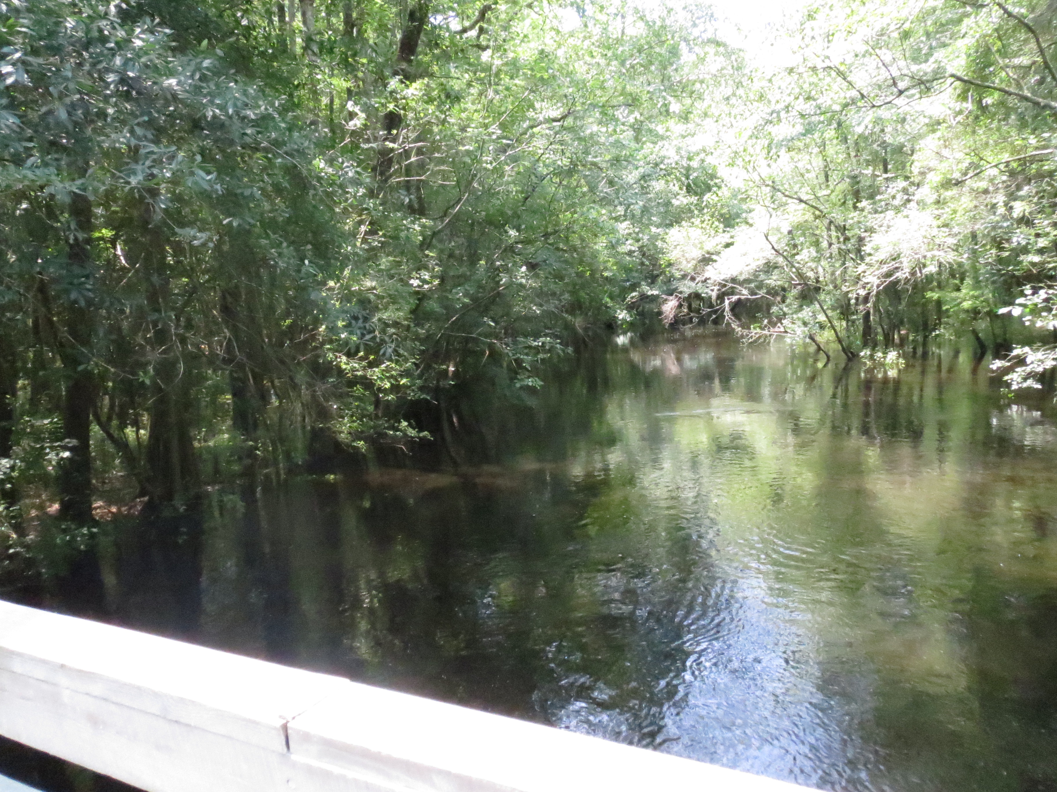
A dark water creek spanned by a wooden boardwalk on one side and a wooden bridge on the other. The boardwalk is relatively flat going across the creek.
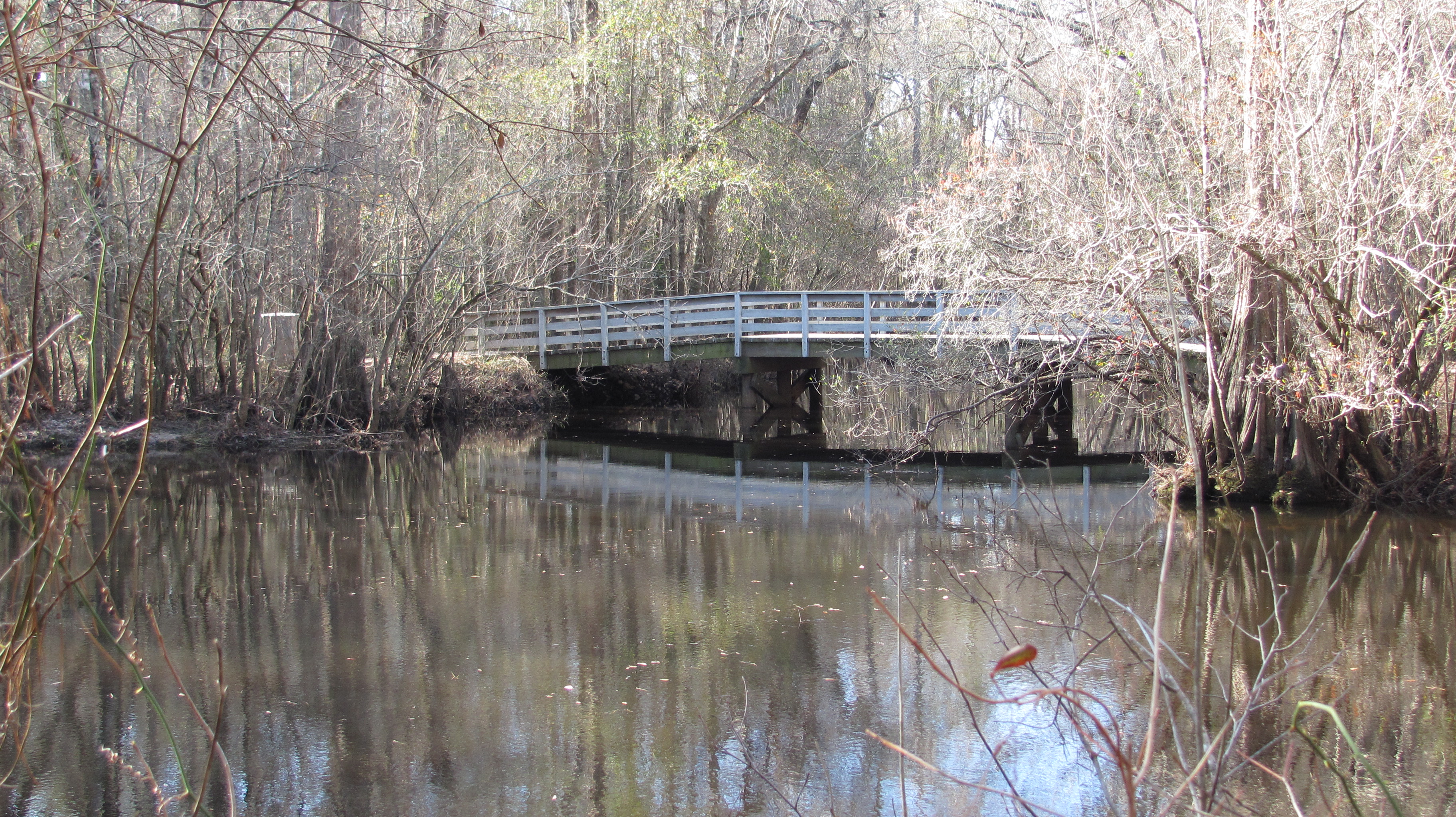
DESCRIBING: A current photo of the wooden Moores Creek bridge SYNOPSIS: A modern recreation of the historical Moores Creek bridge IN-DEPTH DESCRIPTION: The wooden visitor bridge stretches over a calm body of water in a dense forest. The perspective is from beside the visitor footpath, capturing the bridge at an angle. The photo is taken up from the other side of the creek, with the bridge filling the entire scene. The bridge is made of light-colored wooden planks with sturdy railings on both sides with three wide, evenly spaced horizontal slats. The bridge in 1776 would not have had the handrails. They were added to meet modern safety standards. The bridge has a slight slope on either end, with a flat midsection. The surrounding environment is thick with tall, mostly leafless cypress trees, suggesting late autumn or winter. The water beneath is barely visible to the right of the photo. It is still and reflective, mirroring the trees and sky above. Dappled sunlight filters through the trees, casting a warm glow near the top of the frame.
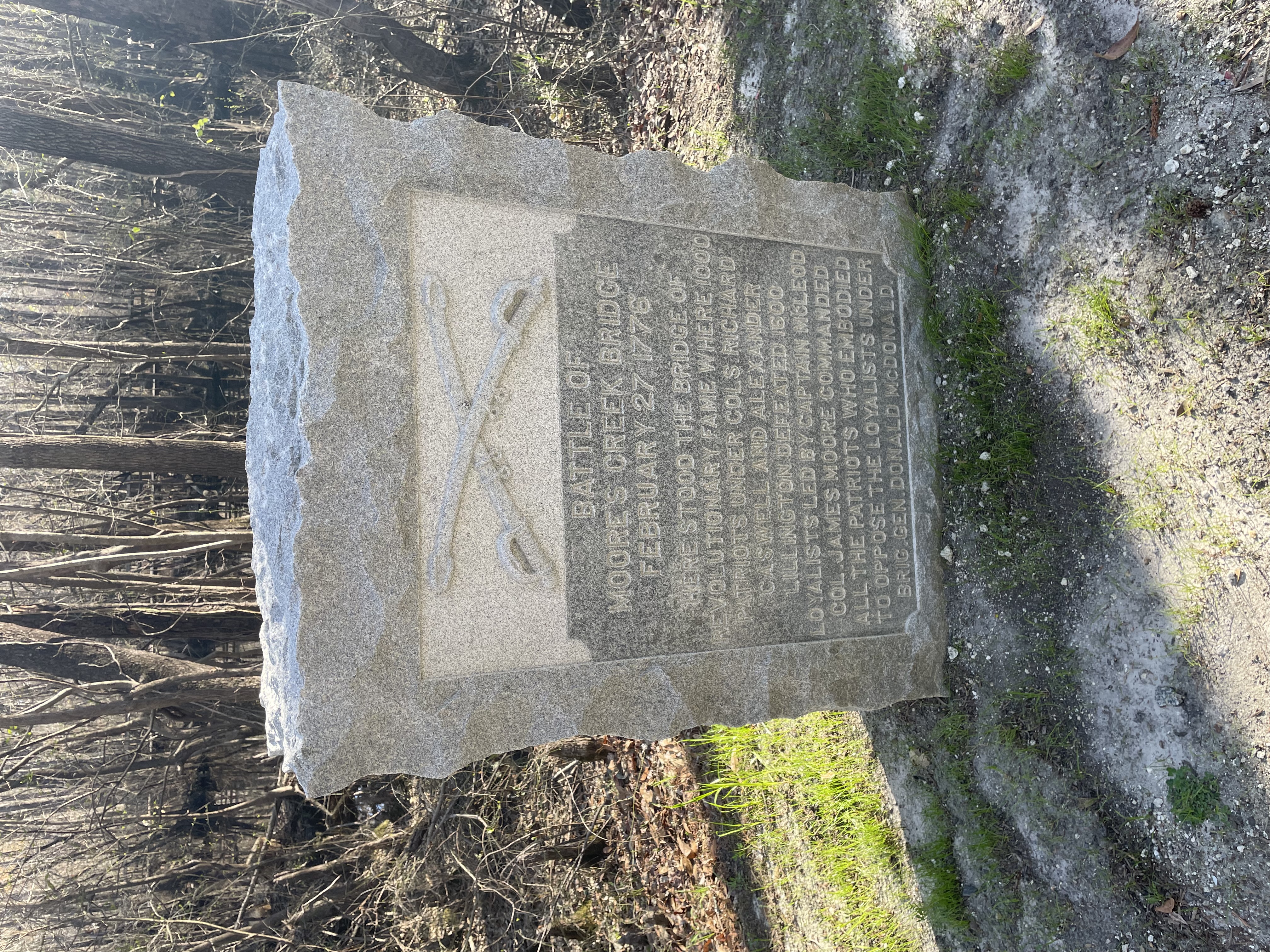
This panel sits on the side of the history trail. To the left is the reconstruction bridge over Moores Creek. To the right the path continues through the woods and then makes a turn to the left. The monument is a vertical rectangle of roughly carved gray granite. At top is a relief carving of two crossed swords. Below the swords carved text reads, "Battle of Moores Creek Bridge, February 27,1776. Here stood the bridge of revolutionary fame where 1000 Patriots under Colonels Richard Caswell and Alexander Lillington defeated 1600 Loyalists led by Captain McLeod. Colonel James Moore commanded all the patriots who embodied to oppose the loyalists under Brigadier General Donald McDonald." Feel free to touch! End of Description.
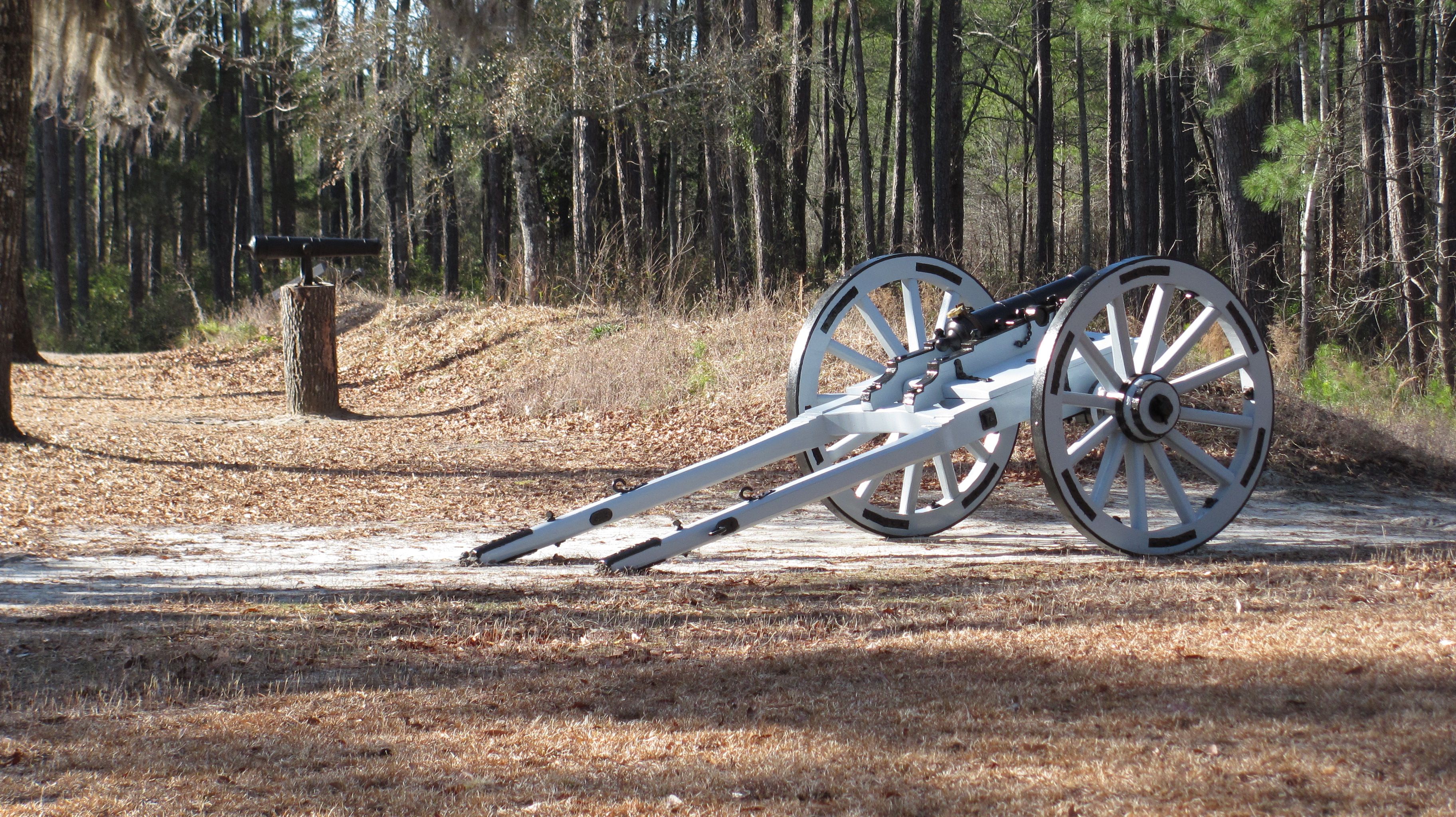
DESCRIBING: A modern photograph of a replica cannon. SYNOPSIS: A historic carriage equipped with a cannon and large, wooden, spoked wheels with metal rims, set against a backdrop of earthworks and dense woodlands. IN-DEPTH DESCRIPTION: A Revolutionary War-era two-pound replica cannon carriage is positioned on a dirt path with slender trees, dry grass, and leaves in the background. There is a low dirt mound behind the cannon, which is a remnant of the historical battleground. The carriage is painted light blue with black metal reinforcements and hardware. It has two large wooden-spoked wheels with metal rims. The wheels are 4 feet in diameter with 12 white spokes. The cannon barrel is small compared to the size of the carriage itself that would attach to a horse. The long wooden horse traces extend from the back of the carriage, resting on the ground with metal fittings. Various metal components, including fastenings and hinges, are visible on the carriage, adding to its sturdy appearance. To the left of the larger cannon is a black iron 1/2 pound smaller cannon. The cannon is mounted inside of a tree stump pointed towards the creek.
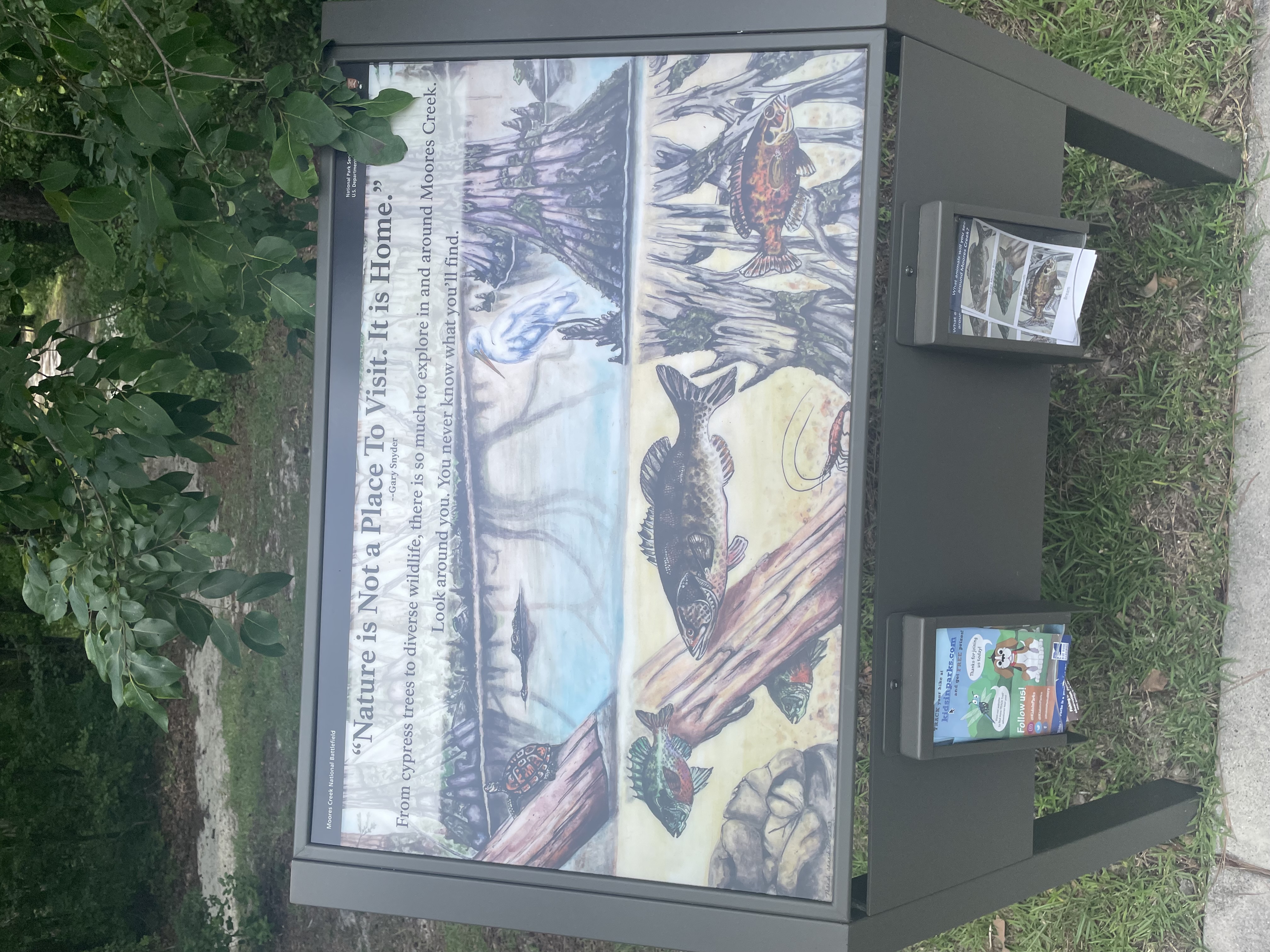
Here at the end of the parking lot are three graphic panels. On the other side of the panels a sandy path leads through the woods heading down to the creek. The sidewalk curves around behind you to the left towards Patriot's Hall, passing the picnic area on the way. This panel is the one on the right. Across the top is a quote from Gary Snyder which reads, "Nature is Not a Place to Visit. It is Home." Text below reads, "From cypress trees to diverse wildlife, there is so much to explore in and around Moores Creek. Look around you. You never know what you'll find." The background of the panel is filled with a color illustration of life in and around the creek. The picture is split with an above water view at top and below the surface view at bottom. At left a fallen log extends out of the water with a tortoise sitting on it. To the right of that is the head of an alligator as it floats by. On the right side a cypress tree rises up out of the water with a blue heron standing nearby. Below the waterline we see an orange speckled fish swimming by the cypress roots. In the middle of the scene is a large brown fish. At left are two smaller fish, greenish gray with red bellies. At the very bottom a crayfish waves its long antennae over its back. Below the panel are small boxes with brochures. At left is a brochure for Kids In Park Track Your Hike. At right is a brochure identifying animals you may see at Moores Creek. End of Description.
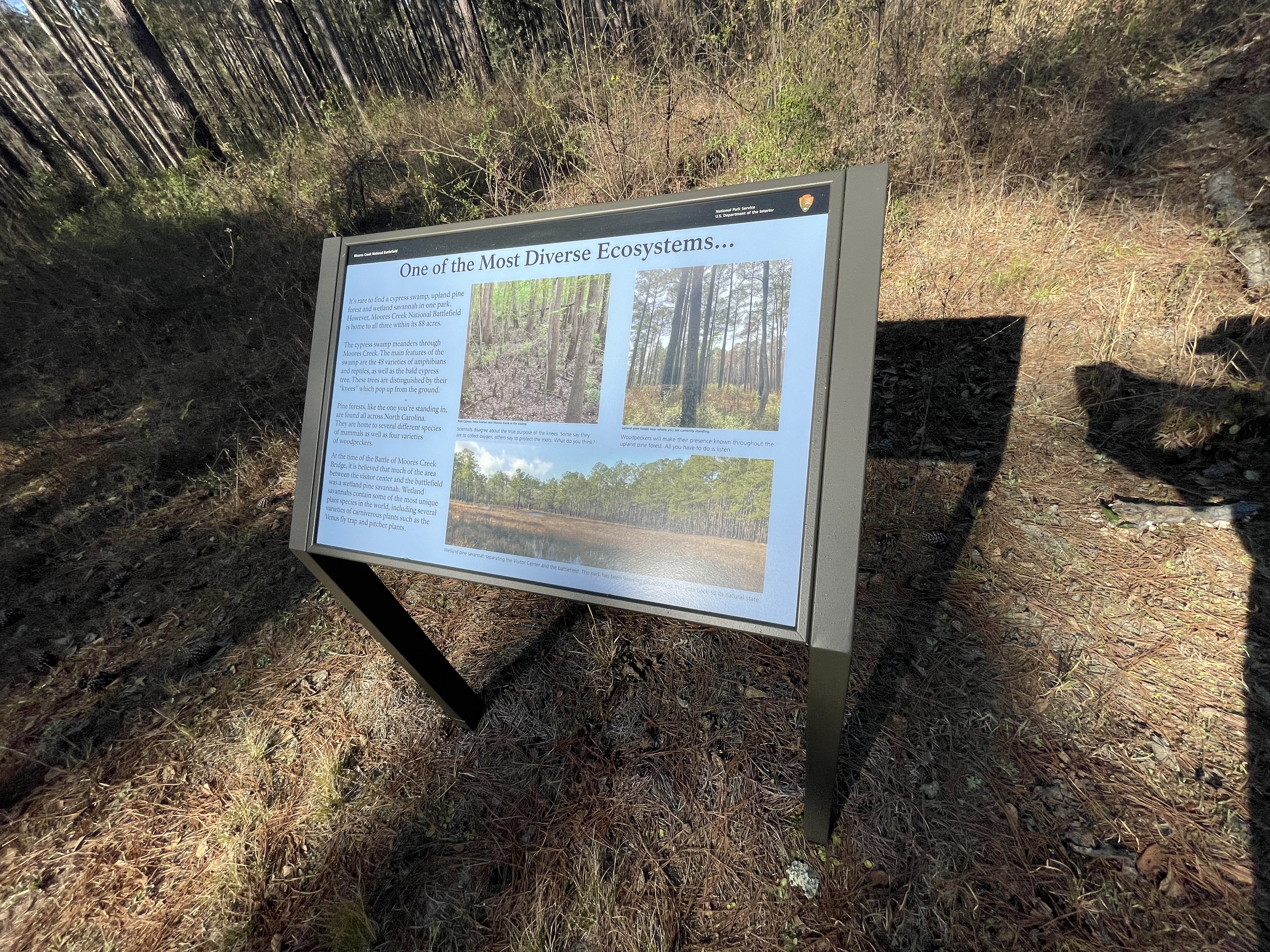
This panel sits on the side of the wide sandy Woodpecker Trail in a small clearing in the middle of open pine woods with low scattered undergrowth. Text down the left side of the panel reads, "It's rare to find a cypress swamp, upland pine forest and wetland savannah in one park. However, Moores Creek National Battlefield is home to all three within its 88 acres. The cypress swamp meanders through Moores Creek. The main features of the swamp are the 48 varieties of amphibians and reptiles, as well as the bald cypress tree. These trees are distinguished by their "knees" which pop up from the ground. "Pine forests, like the one you're standing in, are found all across North Carolina. They are home to several different species of mammals as well as four varieties of woodpeckers. "At the time of the Battle of Moores Creek Bridge, it is believed that much of the area between the visitor center and the battlefield was a wetland pine savannah. Wetland savannahs contain some of the most unique plant species in the world, including several varieties of carnivorous plants such as the Venus fly trap and pitcher plants." On the right side of the panel are photographs of the three ecosystems. At upper left is a photo of some Bald Cypress Trees located near Moores Creek in the swamp. Sticking up from the wet ground between the many tree trunks are dozens of cone-shaped cypress knees. The caption reads, "Scientists disagree about the true purpose of the knees. Some say they are to collect oxygen, others say to protect the roots. What do you think?" To the right is a photo of the pine woods where you are standing with the tall pine trees and low scattered undergrowth. The caption reads, "Woodpeckers will make their presence known throughout the upland pine forest. All you have to do is listen." The photo at bottom shows an open grassy meadow with pools of water scattered about. Around the edge of the meadow are pine woods. The caption reads, "Wetland pine savannah separating the Visitor Center and the battlefield. The park has been working on restoring this area back to its natural state." End of Description.
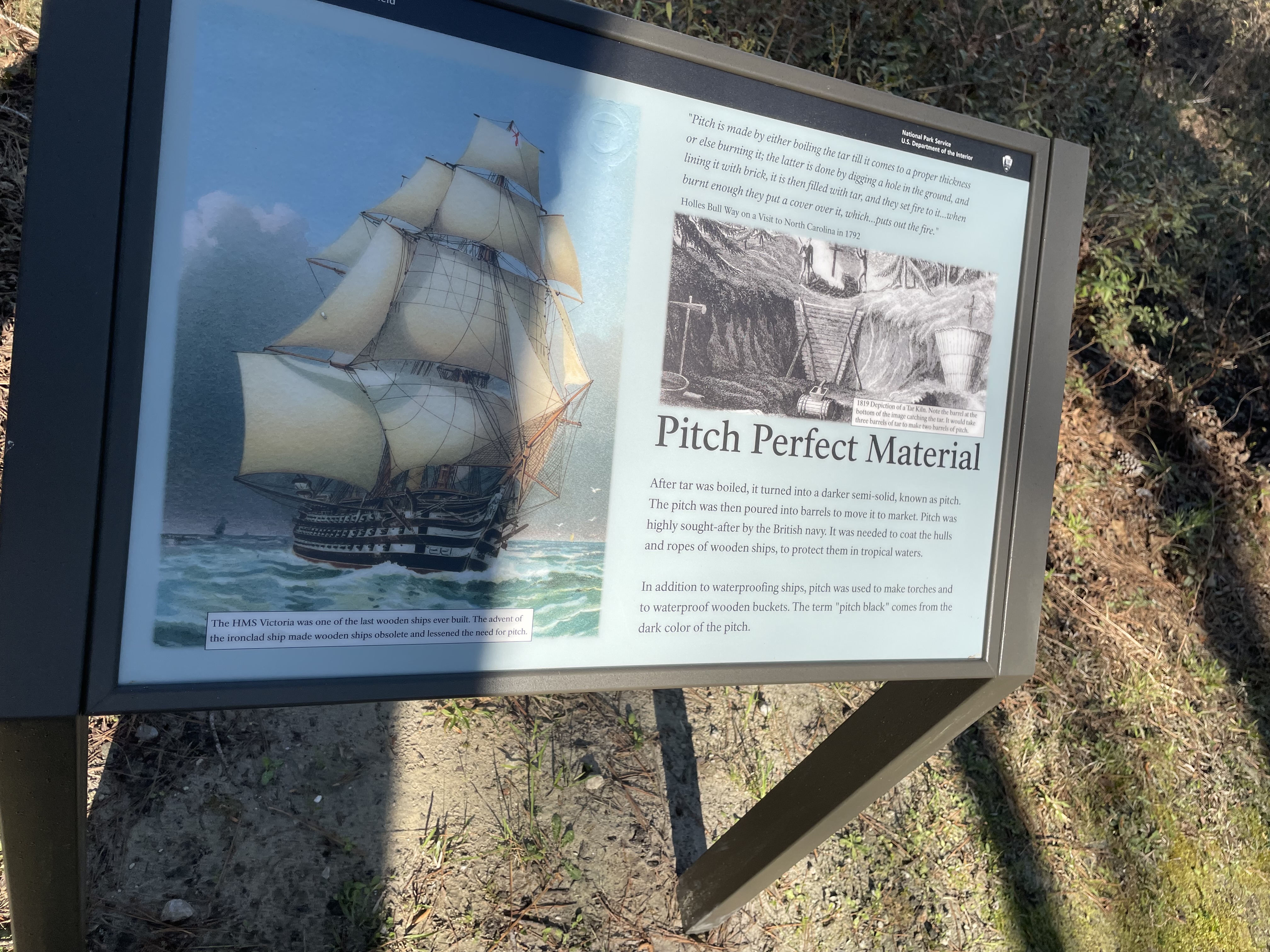
This panel sits on the right side of the Tar Heel Trail in the middle of open pine woods with low scattered undergrowth. To your left as you face the panel is a bench. Down the path in that direction you can see the Black River Road. Back to the right is a trash can. On the left side of the panel is a color illustration of a large sailing ship. It three masts are covered with many sails full of wind. Cannon muzzles can be seen extending from openings lining each of the three decks above the water line. The caption reads, "The HMS Victoria was one of the last wooden ships ever built. The advent of the ironclad ship made wooden ships obsolete and lessened the need for pitch." At upper right on the panel is a quote from Holles Bull Way on a visit to North Carolina in 1792 which reads, "Pitch is made by either boiling the tar till it comes to a proper thickness or else burning it; the latter is done by digging a hole in the ground, and lining it with brick, it is then filled with tar, and they set fire to it...when burnt enough they put a cover over it, which...puts out the fire." Below that is a black and white illustration of a tar kiln. At top center two men tend a large fire at the top of a steep bank. A wood barrier is propped against the bank below the fire with a pipe extending out of the bottom. Below the end of the pipe is a barrel to catch the material flowing out. The caption reads, "1819 Depiction of a Tar Kiln. Note the barrel at the bottom of the image catching the tar. It would take three barrels of tar to make two barrels of pitch." At lower right text reads, "After tar was boiled, it turned into a darker semi-solid, known as pitch. The pitch was then poured into barrels to move it to market. Pitch was highly sought-after by the British navy. It was needed to coat the hulls and ropes of wooden ships, to protect them in tropical waters. In addition to waterproofing ships, pitch was used to make torches and to waterproof wooden buckets. The term "pitch black" comes from the dark color of the pitch." End of Description.
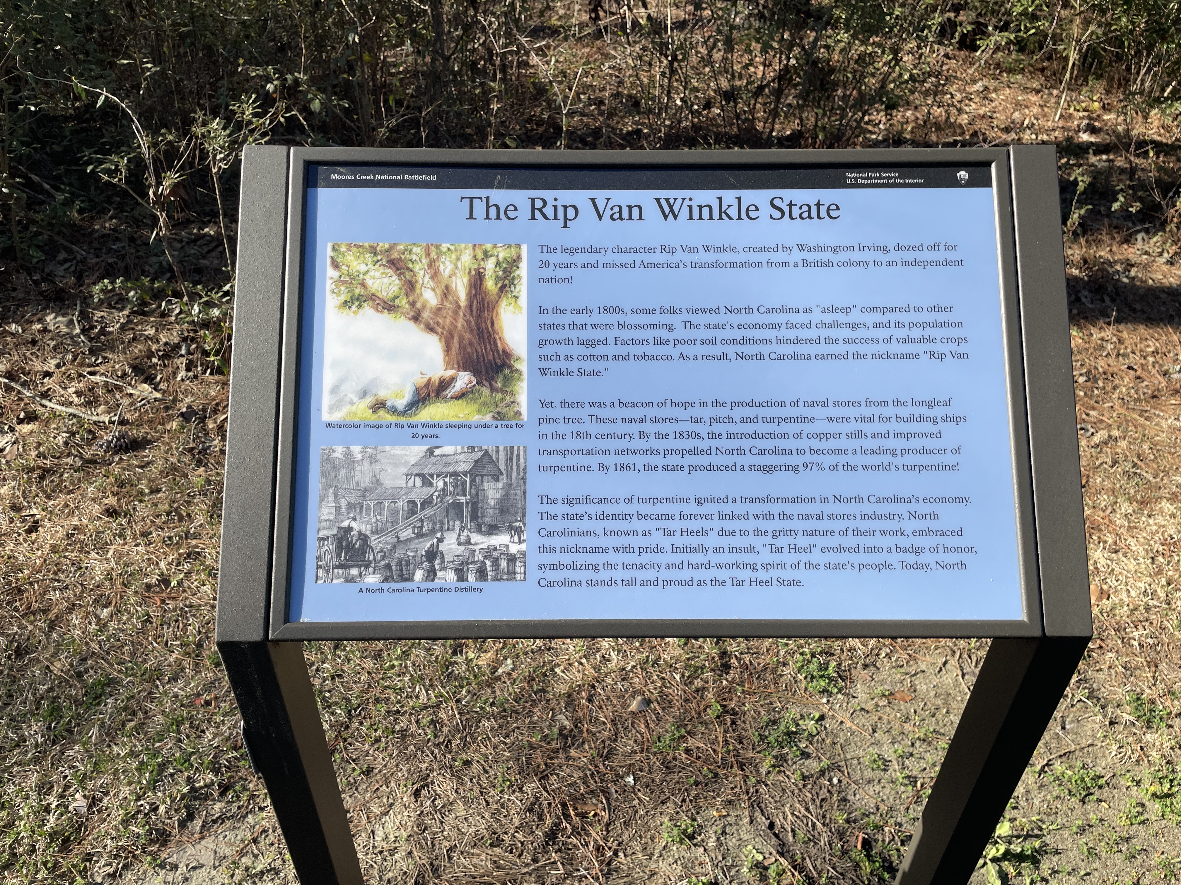
This panel sits on the side of the paved Tar Heel Trail near the end of the trail. To the right as you face the panel is the parking lot in front of the Visitor Center. Behind you is part of the sand and gravel Black River Road with the park entrance road on the other side of it. To your left the trail parallels the Black River Road for a few yards before turning back into the woods. On the other side of the panel are pine woods with low undergrowth. Down the left side of the panel are two images. At top is a color illustration of a man with white hair and long beard curled up asleep under a large tree. The caption reads, "Watercolor image of Rip Van Winkle sleeping under a tree for 20 years." Below that is a black and white illustration of a two-story, open-sided wooden building with a long ramp leading up to the second floor in front. A man is rolling a barrel up the ramp. In the foreground two Black men are unloading barrels from the back of an open wagon. Many other barrels are sitting on the ground. The caption reads, "A North Carolina Distillery." Text on the right side of the panel reads, "The legendary character Rip Van Winkle, created by Washington Irving, dozed off for 20 years and missed America's transformation from a British colony to an independent nation! In the early 1800s, some folks viewed North Carolina as "asleep" compared to other states that were blossoming. The state's economy faced challenges, and its population growth lagged. Factors like poor soil conditions hindered the success of valuable crops such as cotton and tobacco. As a result, North Carolina earned the nickname "Rip Van Winkle State." "Yet, there was a beacon of hope in the production of naval stores from the longleaf pine tree. These naval stores—tar, pitch, and turpentine —were vital for building ships in the 18th century. By the 1830s, the introduction of copper stills and improved transportation networks propelled North Carolina to become a leading producer of turpentine. By 1861, the state produced a staggering 97% of the world's turpentine! "The significance of turpentine ignited a transformation in North Carolina's economy. The state's identity became forever linked with the naval stores industry. North Carolinians, known as "Tar Heels" due to the gritty nature of their work, embraced this nickname with pride. Initially an insult, "Tar Heel" evolved into a badge of honor, symbolizing the tenacity and hard-working spirit of the state's people. Today, North Carolina stands tall and proud as the Tar Heel State." End of Description.
Wayside Exhibit focused on the leadup to the Battle of Moores Creek Bridge.
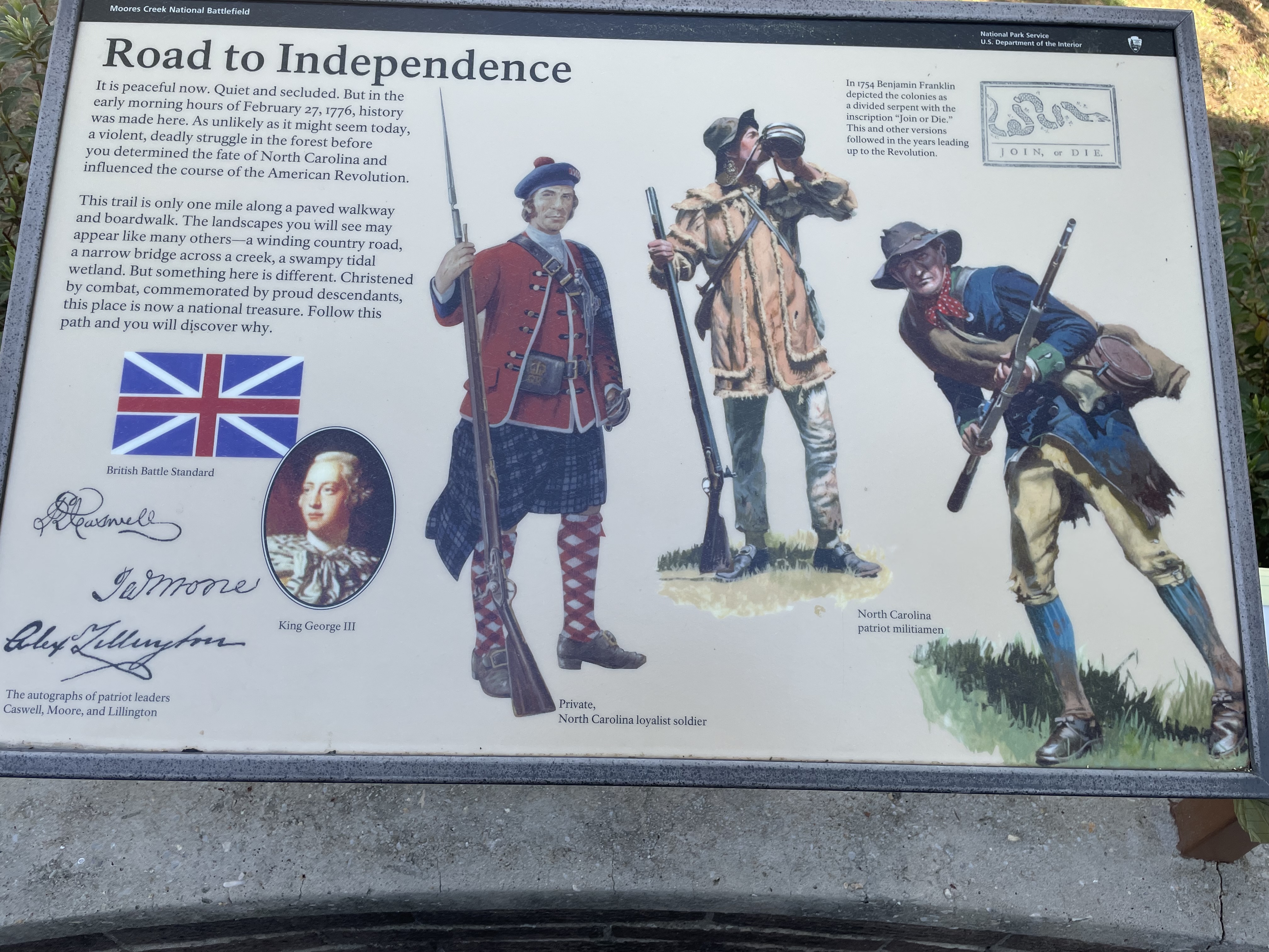
This horizontal panel is attached to a low railing that encloses a semicircular patio behind the Visitor Center. The metal railing sits on top of a low brick wall. The back entrance to the Visitor Center is near the right end of the patio as you face the panel. Near the left end, along the building, is a bench. At the left end is an opening which leads down to the History Trail. As you face the panel you can see the History Trail leading off to the right through tall trees. Beyond the trees is an open meadow. On the railing to your immediate right is a bronze plaque with raised text which reads, "In memory of James Moore. Born 1737, New Hanover County, North Carolina. Died 15 January 1777, Wilmington, North Carolina. Colonel, First Regiment, North Carolina Continental Line, whose strategy led to the Patriots' victory over the Loyalists at the Battle of Moores Creek Bridge, 27 February 1776. This memorial erected by the North Carolina Society of the Cincinnati, Anno domini MMII." On the panel in front of you text at upper left reads, "It is peaceful now. Quiet and secluded. But in the early morning hours of February 27, 1776, history was made here. As unlikely as it might seem today, a violent, deadly struggle in the forest before you determined the fate of North Carolina and influenced the course of the American Revolution. This trail is only one mile along a paved walkway and boardwalk. The landscapes you will see may appear like many others—a winding country road, a narrow bridge across a creek, a swampy tidal wetland. But something here is different. Christened by combat, commemorated by proud descendants, this place is now a national treasure. Follow this path and you will discover why." Below the text is the British Battle Standard or flag with its blue background, white X, and red cross. Below and to the right is a portrait of King George III. In the lower left corner are images of the signatures, or autographs, of the patriot leaders. At top is Caswell. Next down is Moore. At the bottom is Lillington. On the right side of the panel are color illustrations of three men. At left is a man wearing a dark plaid kilt with a red jacket and vest and a dark beret. His legs are covered with knee-high red and white plaid stocking. He holds a long musket with a bayonet in his right hand. The caption reads, "Private, North Carolina loyalist soldier." To the right are two more figures. One wears long pants and a tan jacket with fringed edges. He holds a long gun in his right hand as her drink from a canteen. The other figure wear knee britches and long stockings and a long blue jacket. He has a red bandana around his neck and carries his long gun in both hands. Both men wear soft hats with wide brims. The caption reads, "North Carolina patriot militiamen." In the upper right of the panel is a drawing of a long snake cut into eight pieces. Words below read "Join or Die." Text to the left reads, "In 1754 Benjamin Franklin depicted the colonies as a divided serpent with the inscription 'Join or Die.' This and other versions followed in the years leading up to the Revolution." To the right of the panel is a small sign indicating that this is stop number 1 on an audio tour which you may get from the Visitor Center. End of Description.
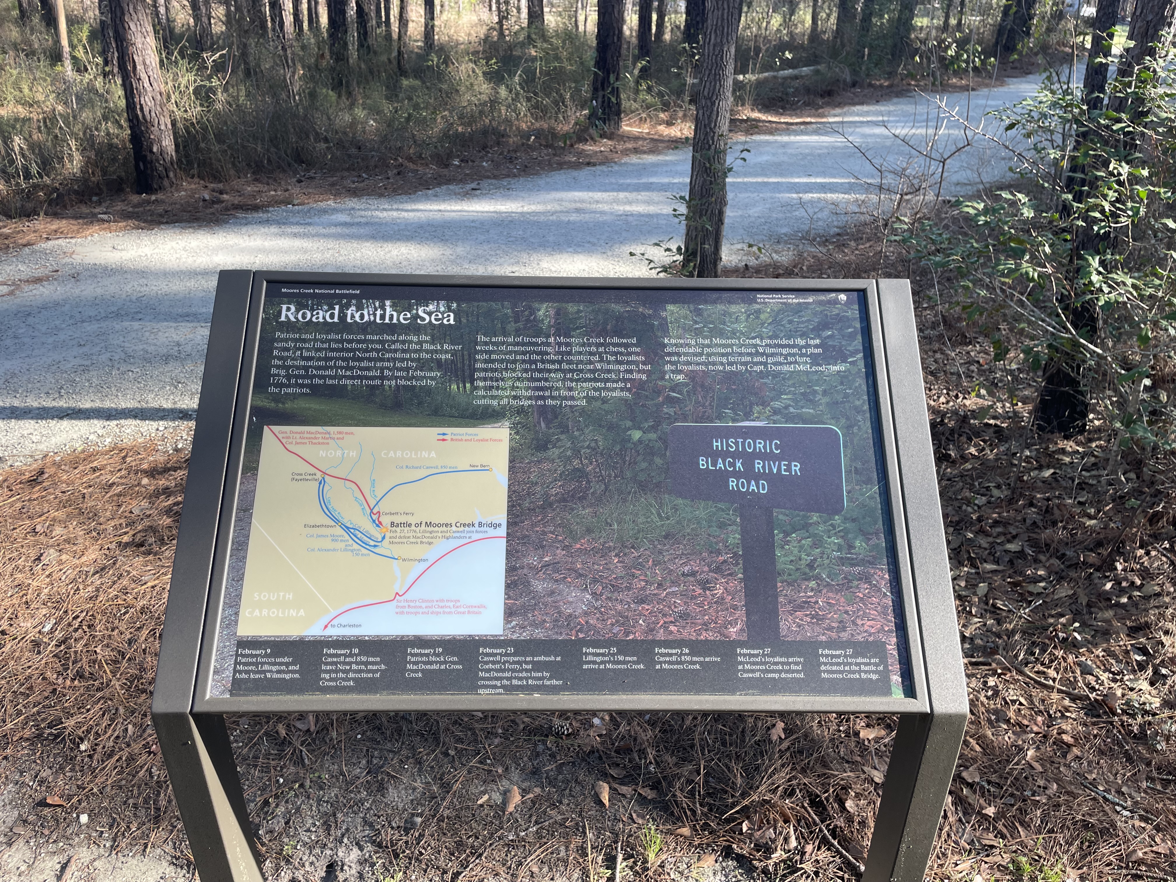
This panel sits at the intersection of the paved path from the Visitor Center and the dirt-surfaced Black River Road. As you face the panel, the Visitor Center is to your right. A few yards in the direction are a bench and a water station. Thin pine woods surround you. The Black River Road is to your right and runs in two directions. If you turn right on that road, you will reach Patriots Hall. Turn left on the road to continue the History Trail. The background of the panel features a photograph of a small sign reading "Historic Black River Road" posted at the edge of the woods. Text across the top of the panel reads, "Patriot and loyalist forces marched along the sandy road that lies before you. Called the Black River Road, it linked interior North Carolina to the coast, the destination of the loyalist army led by Brigadier General Donald MacDonald. By late February 1776, it was the last direct route not blocked by the patriots. The arrival of troops at Moores Creek followed weeks of maneuvering. Like players at chess, one side moved and the other countered. The loyalists intended to join a British fleet near Wilmington, but patriots blocked their way at Cross Creek. Finding themselves outnumbered, the patriots made a calculated withdrawal in front of the loyalists, cutting all bridges as they passed. Knowing that Moores Creek provided the last defendable position before Wilmington, a plan was devised, using terrain and guile, to lure the loyalists, now led by Captain Donald McLeod, into a trap." At lower left on the panel is a map of the area with Cross Creek (Fayetteville) in upper left and the coast south of Wilmington at lower right. Blue lines show the movement of the Patriot forces and red lines show the movement of the British and Loyalist force. One red line representing General Donald MacDonald, 1,580 men, with Lieutenant Alexander Martin and Colonel James Thackston, comes down from upper left, goes past Cross Creek (Fayetteville), crosses the Cape Fear River, South River, and the Black River, and end at Moores Creek Bridge. Another red line goes southward along the coast representing Sir Henry Clinton with troops from Boston and Charles, Earl Cornwallis, with troops and ships from Great Britain. One blue line representing Colonel Richard Caswell, 850 men, goes west from New Bern, crosses the Black River, and ends at Moores Creek. From Wilmington a blue line representing Colonel James Moore, 900 men, and Colonel Alexander Lillington, 150 men, goes up to Cross Creek, then return down to Elizabethtown, where the line splits. Lillington's forces loop around to Moores Creek. Moore's forces head down to the confluence of Cape Fear River and South River. At Moores Creek is a yellow star and text that reads, " Battle of Moores Creek Bridge. February 27, 1776, Lillington and Caswell join forces and defeat MacDonald's Highlanders at Moores Creek Bridge." Across the bottom is a timeline with the various movements. Beginning at the left the entries read: "February 9. Patriot forces under Moore, Lillington, and Ashe leave Wilmington. February 10. Caswell and 850 men leave New Bern, marching in the direction of Cross Creek. February 19. Patriots block General MacDonald at Cross Creek. February 23. Caswell prepares an ambush at Corbett's Ferry, but MacDonald evades him by crossing the Black River farther upstream. February 25. Lillington's 150 men arrive at Moores Creek. February 26. Caswell's 850 men arrive at Moores Creek. February 27. McLeod's loyalists arrive at Moores Creek to find Caswell's camp deserted. February 27. McLeod's loyalists are defeated at the Battle of Moores Creek Bridge." Below the panel is a small sign indicating that this is stop number 3 on an audio tour which you may get from the Visitor Center. End of Description.
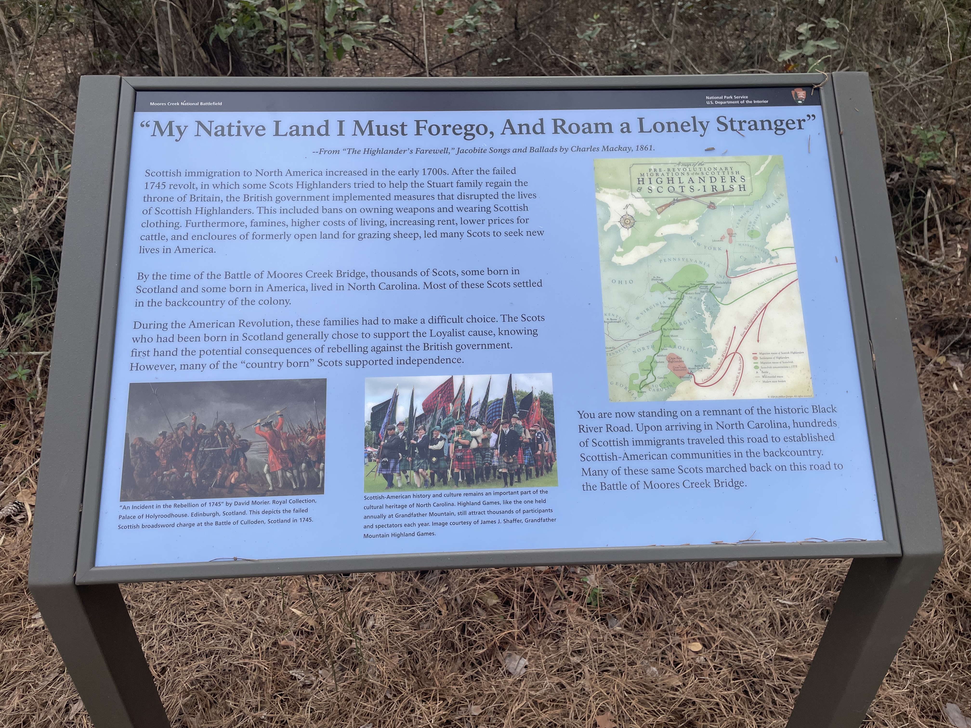
This panel sits at the side of the sand and gravel Black River Road near the intersection with the paved path from the Visitor Center. As you face the panel the reconstructed bridge over Moores Creek lies a few yards down the road to your left. Thick woods line both sides of the road here. The title of this panel across the top is a quote from The Highlander's Farewell, a collection of Jacobite Songs and Ballads by Charles Mackay, 1861, which reads, "My Native Land I Must Forego, And Roam a Lonely Stranger." Text on the left side of the panel reads, "Scottish immigration to North America increased in the early 1700s. After the failed 1745 revolt, in which some Scots Highlanders tried to help the Stuart family regain the throne of Britain, the British government implemented measures that disrupted the lives of Scottish Highlanders. This included bans on owning weapons and wearing Scottish clothing. Furthermore, famines, higher costs of living, increasing rent, lower prices for cattle, and enclosures of formerly open land for grazing sheep, led many Scots to seek new lives in America. By the time of the Battle of Moores Creek Bridge, thousands of Scots, some born in Scotland and some born in America, lived in North Carolina: Most of these Scots settled in the backcountry of the colony. During the American Revolution, these families had to make a difficult choice. The Scots who had been born in Scotland generally chose to support the Loyalist cause, knowing first hand the potential consequences of rebelling against the British government. However, many of the "country born" Scots supported independence." Below the text are two images. At left is a painting showing a group of highlanders wearing kilts and berets and wielding swords at left. Facing them at right are British soldiers in red jackets and white stockings. They carry long guns with bayonets pointe at the Scotsmen. The caption reads, "'An Incident in the Rebellion of 1745' by David Morier. Royal Collection, Palace of Holyroodhouse, Edinburgh, Scotland. This depicts the failed Scottish broadsword charge at the Battle of Culloden, Scotland in 1745." To the right of that is a current-day photograph of a group of people marching towards us. They wear kilts in a variety of plaids and soft berets on their heads. Many carry flags in a variety of tartan plaids. The caption reads, "Scottish-American history and culture remains an important part of the cultural heritage of North Carolina. Highland Games, like the one held annually at Grandfather Mountain, still attract thousands of participants and spectators each year. Image courtesy of James J. Shaffer, Grandfather Mountain Highland Games." On the right side of the panel is a map titled "Pre-revolutionary Migration of the Scottish Highlanders and Scots-Irish." It shows the eastern part of the United States along the Atlantic coast from Maine down to Georgia. Red lines show migration routes of the Highlanders. One line comes into the US south of New York City and then turns north towards a red area showing their settlements along the Hudson Valley. Another red line swings down to the Wilmington area, where a large red area shows the settlement in southeastern North Carolina. From there another red line shows movement of the Loyalists south to Florida and the West Indies or north to Nova Scotia and Great Britain. One green line shows the Scots-Irish coming into Massachusetts and up to a settlement, marked by a green area, in southern New Hampshire. A second green line, labeled as coming from Ulster, comes into northern Delaware, then moves inland and south along the Appalachians. A large green area stretches from south central Pennsylvania down western Virginia, through the Carolinas, all the way to north Georgia. Text below the map reads, "You are now standing on a remnant of the historic Black River Road. Upon arriving in North Carolina, hundreds of Scottish immigrants traveled this road to established Scottish-American communities in the backcountry. Many of these same Scots marched back on this road to the Battle of Moores Creek Bridge." End of Description.
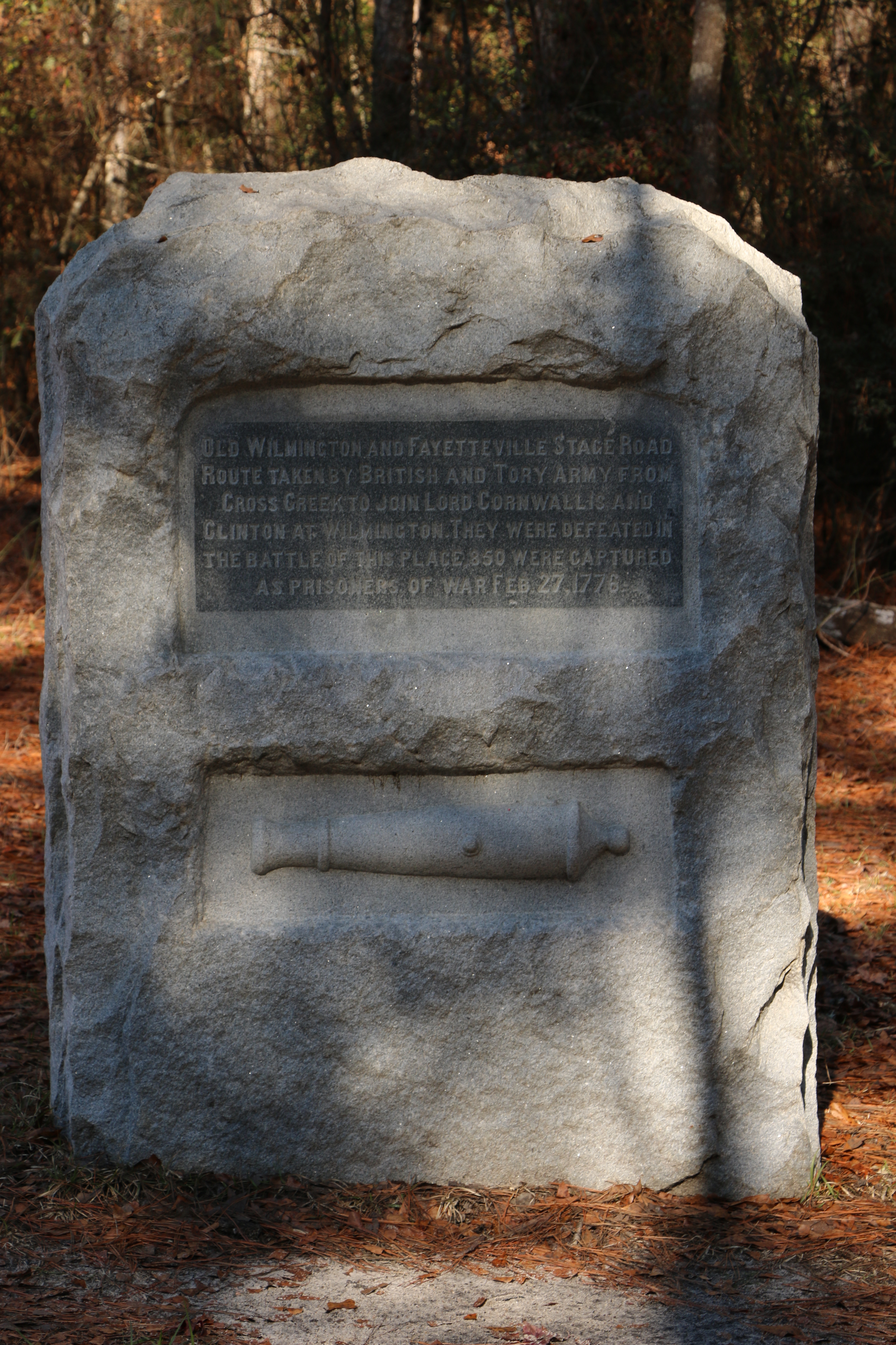
This panel sits on the side of the wide sand and gravel Black River Road . To the right on that road is Patriots Hall. Left on the road continues the History Trail. A few yards to the left the road passes through the remains of the Patriot's earthworks. A small sign there reads, "These earthworks are visible reminders of the heavy fighting that occurred here. Please help preserve these fragile earthworks for future generations by not climbing or walking on them." The monument is a vertical rectangle made of roughly carved gray granite. At top carved text reads, "Old Wilmington and Fayetteville stage road route taken by British and Tory army from Cross Creek to join Lord Cornwallis and Clinton at Wilmington. They were defeated in the battle of this place,850 were captured as prisoners of war. February 27,1776." Below the text is a relief carving of a small cannon. Feel free to touch! To the right of the monument is a small sign indicating that this is stop number 4 on an audio tour which you may get from the Visitor Center. End of Description
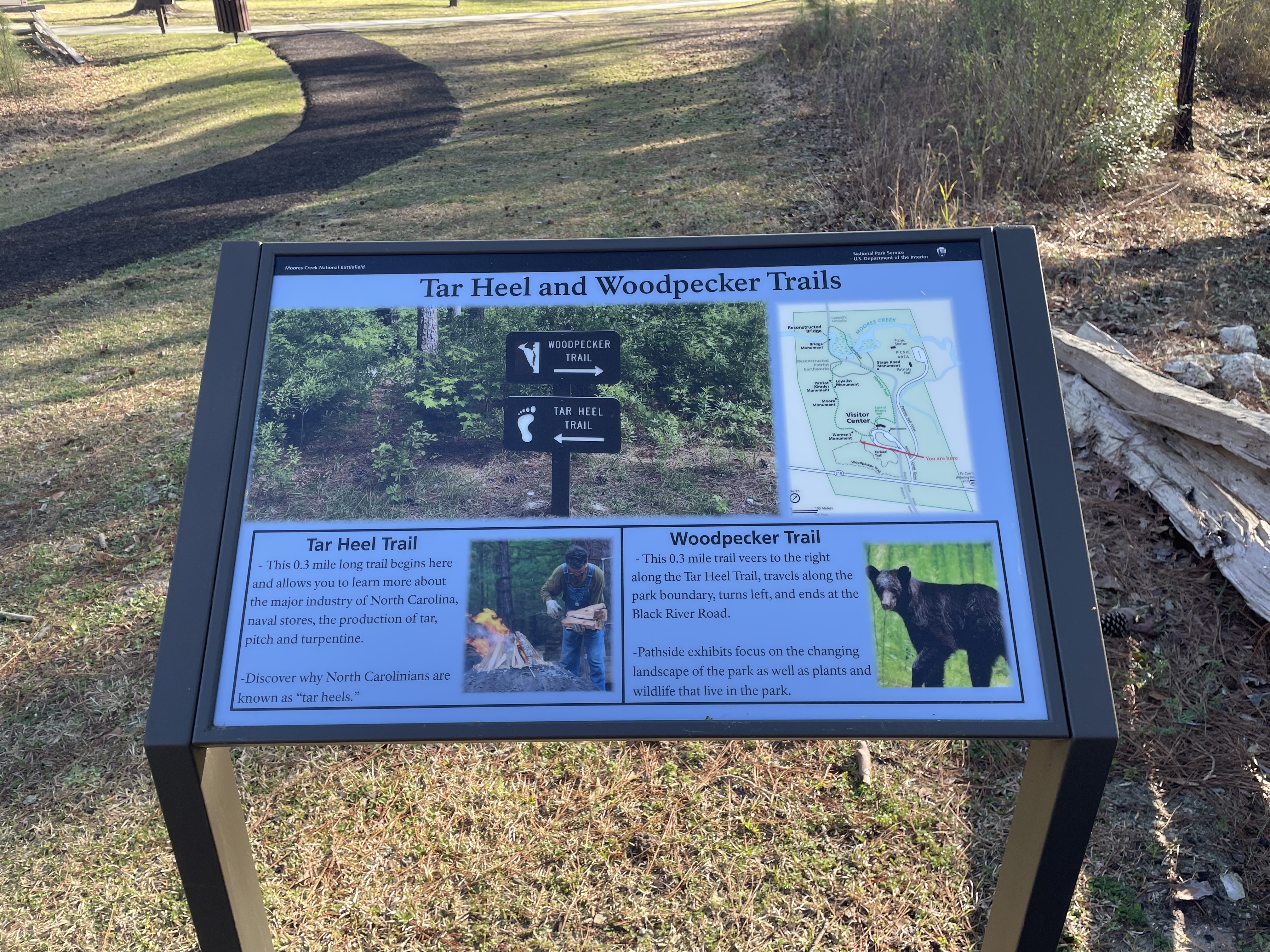
This panel sits along a paved path that leads to two trails through the woods to your right. Immediately to the right the path passes a drainage ditch on the left enclosed by a split rail fence. You may hear running water there. To your left as you face the sign is the end of the History Trail with the parking lot ahead of you and the path leading to the battlefield behind you. At the top of the panel is a photograph of a sign post in the woods with an arrow pointing to the right for the Woodpecker Trail and an arrow pointing left for the Tar Heel Trail. At bottom left on the panel text reads, "Tar Heel Trail. This 0.3 mile long trail begins here and allows you to learn more about the major industry of North Carolina, naval stores, the production of tar, pitch and turpentine. Discover why North Carolinians are known as 'tar heels.'" To the right of the text is a photograph of a man wearing overalls holding an armful of firewood. He is placing logs on a fire at left. At bottom right on the panel text reads, "Woodpecker Trail. This 0.3 mile trail veers to the right along the Tar Heel Trail, travels along the park boundary, turns left, and ends at the Black River Road. Pathside exhibits focus on the changing landscape of the park as well as plants and wildlife that live in the park." To the right of the text is a photograph of a black bear, head turned to look in our direction. At upper right on the panel is a map of the park. Across the top is Moores Creek. Near the middle the creek passes through a swamp. At the left edge of the swamp is the reconstructed bridge over the creek. Across the bottom of the map is Highway 210 with the entrance road to the park near the right side. The park road leads to the Visitor Center at bottom center, then leads up along the right side of the map to Patriots Hall and a picnic area. A grey line marks the route of the Black River Road, which crosses 210 just to the left of the park road, goes straight up to near patriots Hall where it turns to the left, then curves back to cross the bridge near the upper left. From the Visitor Center at lower center a green dotted line marks the History Trail which loops up along the Black River Road, turns upwards to cross the creek on a boardwalk, then continues down over the reconstructed bridge at left. It winds down along the left side and then curves back to the Visitor Center. Location of the various monuments in the park is indicated along that trail. A dark gray line forms a semicircle down from the creek and crossing the Black River Road. This marks the reconstructed Patriot earthworks. The Woodpecker Trail and the Tarheel Trail lie between the Visitor Center and Highway 210. A red arrow indicates your current position at the intersection of the History Trail and the other two trails. End of Description.
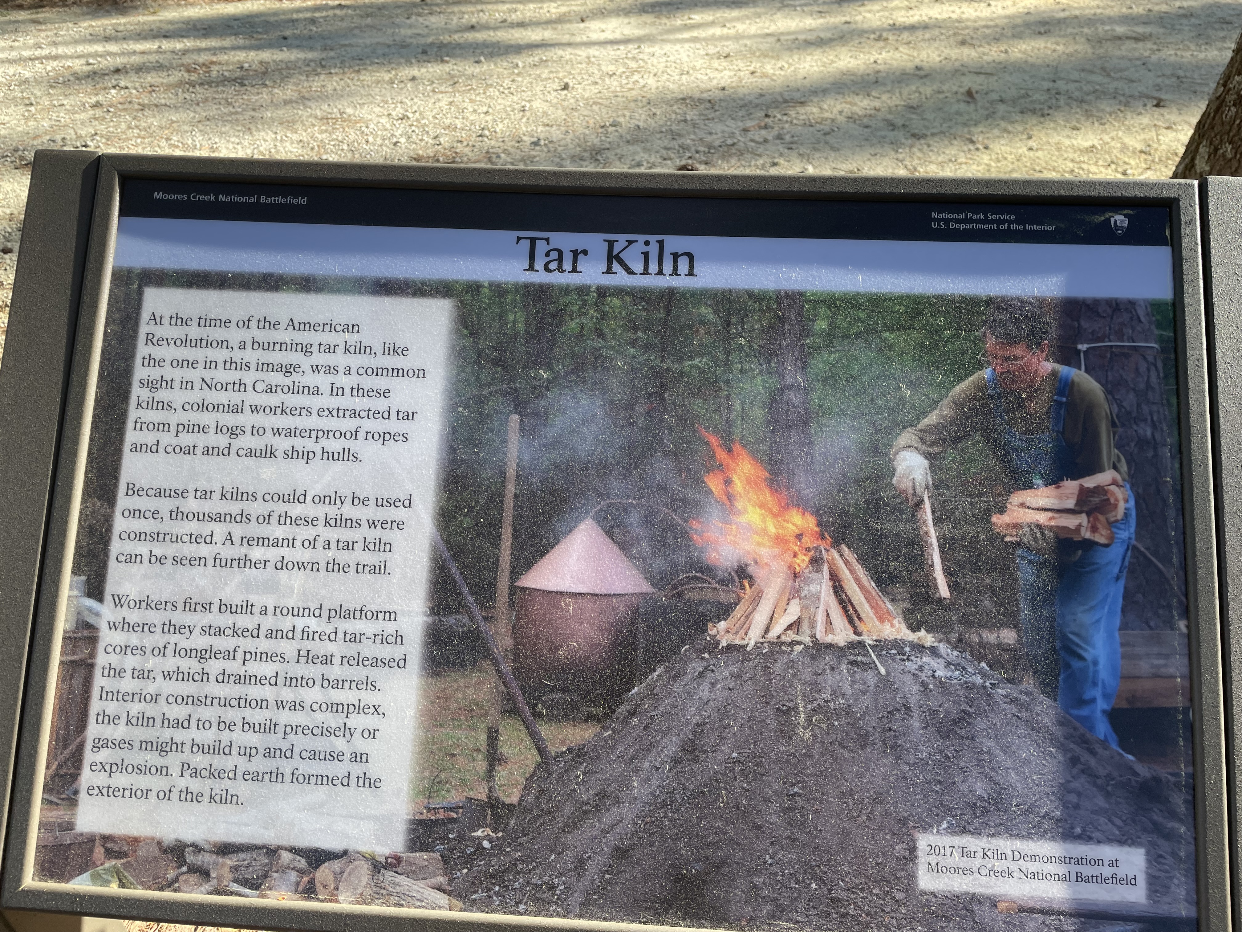
This panel sits on the side of the Black River Road. As you face the panel there is a tar kiln area in front of you circled by a low split-rail fence. On the other side of that is the park entrance road which leads to the Visitor Center to the left. To the right the Black River Road continues out to Highway 210. Behind you is a short wooden footbridge over a low spot which leads back to the paved Tar Heel Trail. The trail continues to the left in the direction of the Visitor Center. The panel features a drawing of a tar kiln. There is a flat mound of earth in the center surrounded by a ditch. Wood planks provide access over the ditch. In the center of the mound is a fire pit, tended by a Black man, On the far side of the fire, another Black man is unloaded log from the back of a wagon. On the side of the mound closest to us a pipe extends out from the bottom with a barrel sitting underneath. Text across the top of the panel reads, "This quiet mound of earth gives no inkling of the smoldering, pungent operation that occurred within. Here colonial workers extracted tar from pine logs to waterproof ropes and rigging and to coat and caulk ship’s hulls. Workers first built a round platform where they stacked and fired tar-rich cores of longleaf pines. Heat released the tar, which drained into barrels. Interior construction was complex, the kiln had to be built precisely or gases might build up and cause an explosion. Packed earth formed the exterior of the kiln." At lower right more text reads, "Because tar kilns could only be used once, thousands of these kilns were constructed. A remnant of a tar kiln can be seen in front of you. This tar kiln is preserved as a reminder of when longleaf pine forests made 18th- century North Carolina a world leader in the production of naval stores." End of Description.
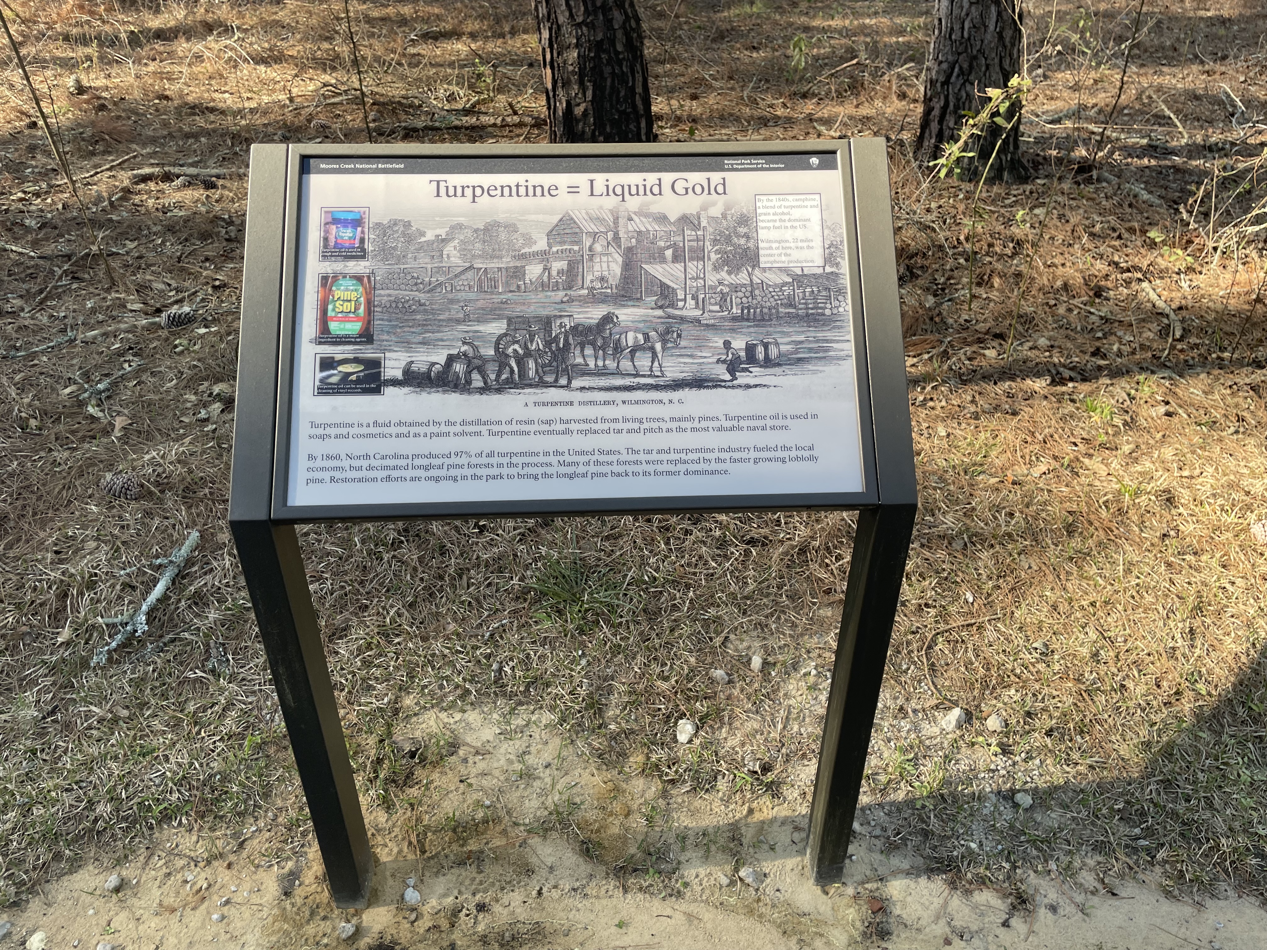
This panel sits on the right side of the Tar Heel Trail in the middle of open pine woods with low scattered undergrowth. Back to your right as you face the panel a short grassy path leads to the Tar Heel Education and Demonstration Area. Across the top of the panel is a black and white illustration of a turpentine distillery in Wilmington. In the center foreground, next to a closed wagon pulled by two horses, a White man gestures to two Black men who stand next to a large barrel. To the left another Black man is moving a barrel. At lower right a small Black boy is running towards the men. The background is dominated by a two story wood building with a large chimney. On a second floor walkway is a row of barrels leading towards a large metal distilling vat with a pipe leading up and away from it. Text at upper right reads, "By the 1840s, camphine, a blend of turpentine and grain alcohol, became the dominant lamp fuel in the US. Wilmington, 22 miles south of here, was the center of the camphene production." Down the left side of the illustration are three photographs. At top is a photo of a jar of Vicks VapoRub. The caption reads, "Turpentine oil is used in cough and cold medicines as a fragrance." Below that is a photo of a bottle of PineSol multi-surface cleaning liquid. The caption reads, "Turpentine oil is a major ingredient in cleaning agents." The bottom photo shows a vinyl record on a turntable. The caption reads, "Turpentine oil can be used in the cleaning of vinyl records." Text across the bottom reads, "Turpentine is a fluid obtained by the distillation of resin (sap) harvested from living trees, mainly pines. Turpentine oil is used in soaps and cosmetics and as a paint solvent. Turpentine eventually replaced tar and pitch as the most valuable naval store. By 1860, North Carolina produced 97% of all turpentine in the United States. The tar and turpentine industry fueled the local economy, but decimated longleaf pine forests in the process. Many of these forests were replaced by the faster growing loblolly pine. Restoration efforts are ongoing in the park to bring the longleaf pine back to its former dominance." End of Description.
This small panel sits to the right of the paved path as you approach from the Visitor Center. Pine woods line both sides of the path. Through the woods behind you as you face the panel you can see an open meadow. To the left, farther along the path is a bench. In an open area behind the sign is a small circular garden edged with flat garden stones. Ferns fill the garden. Nestled among the ferns are small Venus fly trap plants. Only a few inches high they have several flat stems radiating from the ground. At the end of each is the trap, two hinged oval leaf-like structures with long spines along each edge. Please do not touch the plants. The left side of the small panel features a photograph of the traps at the end of the plant stems. The title, "The Most Wonderful Plant in the World," is a quote from Charles Darwin, 1875. Text on the right side reads, "The Venus Fly Trap looks like any other plant, but it contains a deadly secret. It is one of the only carnivorous plants in the world. How does such a simple plant lure unsuspecting animals? The plant gives off a smell that attracts potential prey (namely insects, spiders, and beetles). The animals fly into the open trap and start pressing against the exposed hairs. Once the hairs have been triggered twice, the trap slowly starts to close on the unsuspecting animal. After a few days of digestion, the plant reopens, ready for its next meal. Humans continue to be fascinated with this plant and as a result the plant is on the endangered species list. Moores Creek National Battlefield is one of the only places you will find these wonders of nature in the wild." Below the panel is a small sign indicating that this is stop number 2 on an audio tour which you may get from the Visitor Center. End of Description.
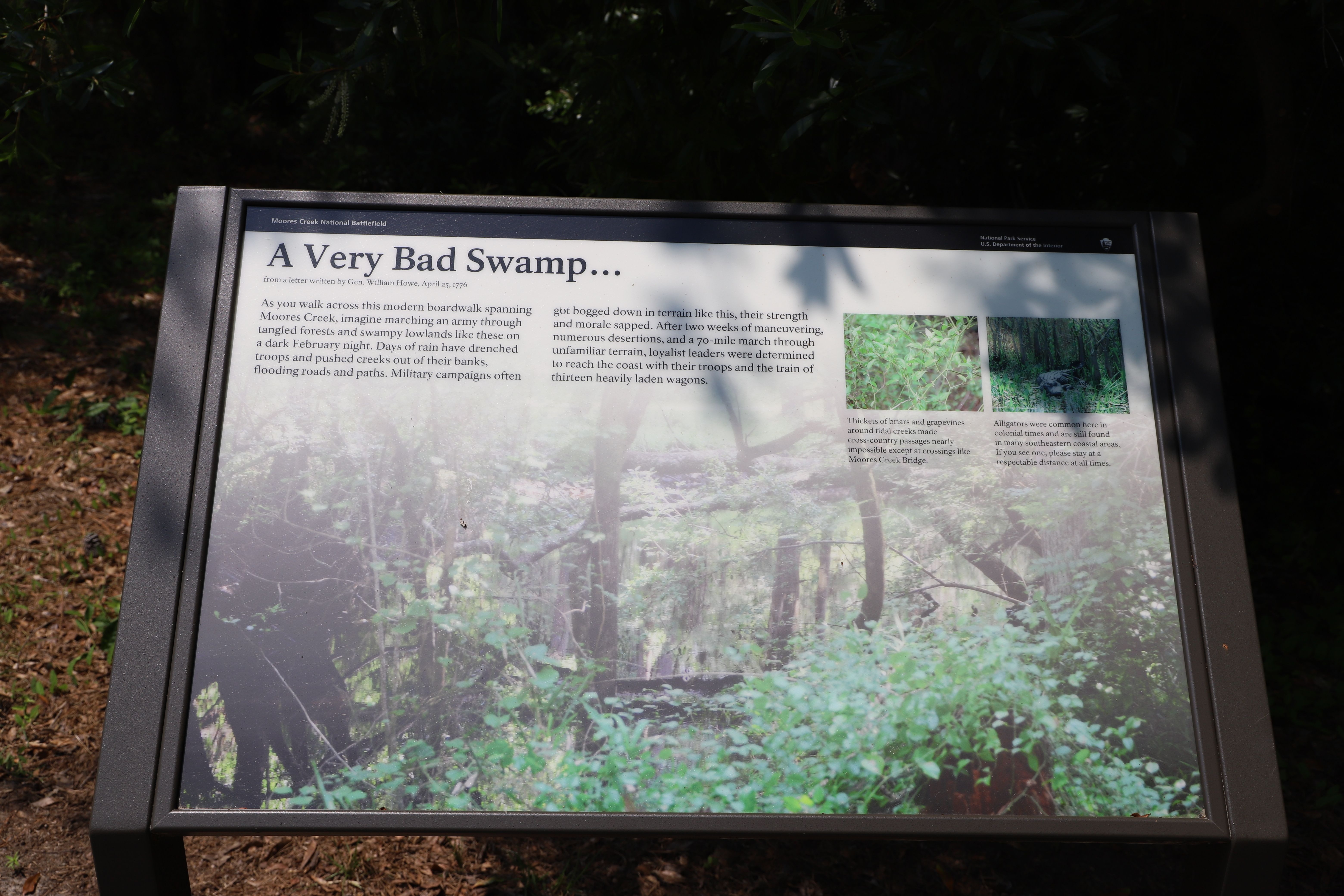
This panel sits along the paved path north of the Black River Road on the edge of the swampy creek to the right. Just past the panel the path connects to a boardwalk that crosses the wide swamp. The remains of the Patriot's earthen embankment make a wide circle behind you, far to the left on the other side of the Black River Road, and in front of you. The background of the panel has a photograph of the still water of the creek with a tangle of trees, shrubs, and fallen logs on both sides. Across the top is the title "A Very Bad Swamp," which is a quote from a letter by General William Howe, April 25, 1776. Text at upper left reads, "As you walk across this modern boardwalk spanning Moores Creek, imagine marching an army through tangled forests and swampy lowlands like these on a dark February night. Days of rain have drenched troops and pushed creeks out of their banks, flooding roads and paths. Military campaigns often got bogged down in terrain like this, their strength and morale sapped. After two weeks of maneuvering, numerous desertions, and a 70-mile march through unfamiliar terrain, loyalist leaders were determined to reach the coast with their troops and the train of thirteen heavily laden wagons." At upper right are two small photographs. The first one shows a tangle of vines with green leaves. The caption reads, "Thickets of briars and grapevines around tidal creeks made cross-country passages nearly impossible except at crossings like Moores Creek Bridge." The next photo shows an alligator facing us as it lies on a reed-covered bank. The caption reads, "Alligators were common here in colonial times and are still found in many southeastern coastal areas. If you see one, please stay at a respectable distance at all times." Below the panel is a small sign indicating that this is stop number 5 on an audio tour which you may get from the Visitor Center. End of Description.
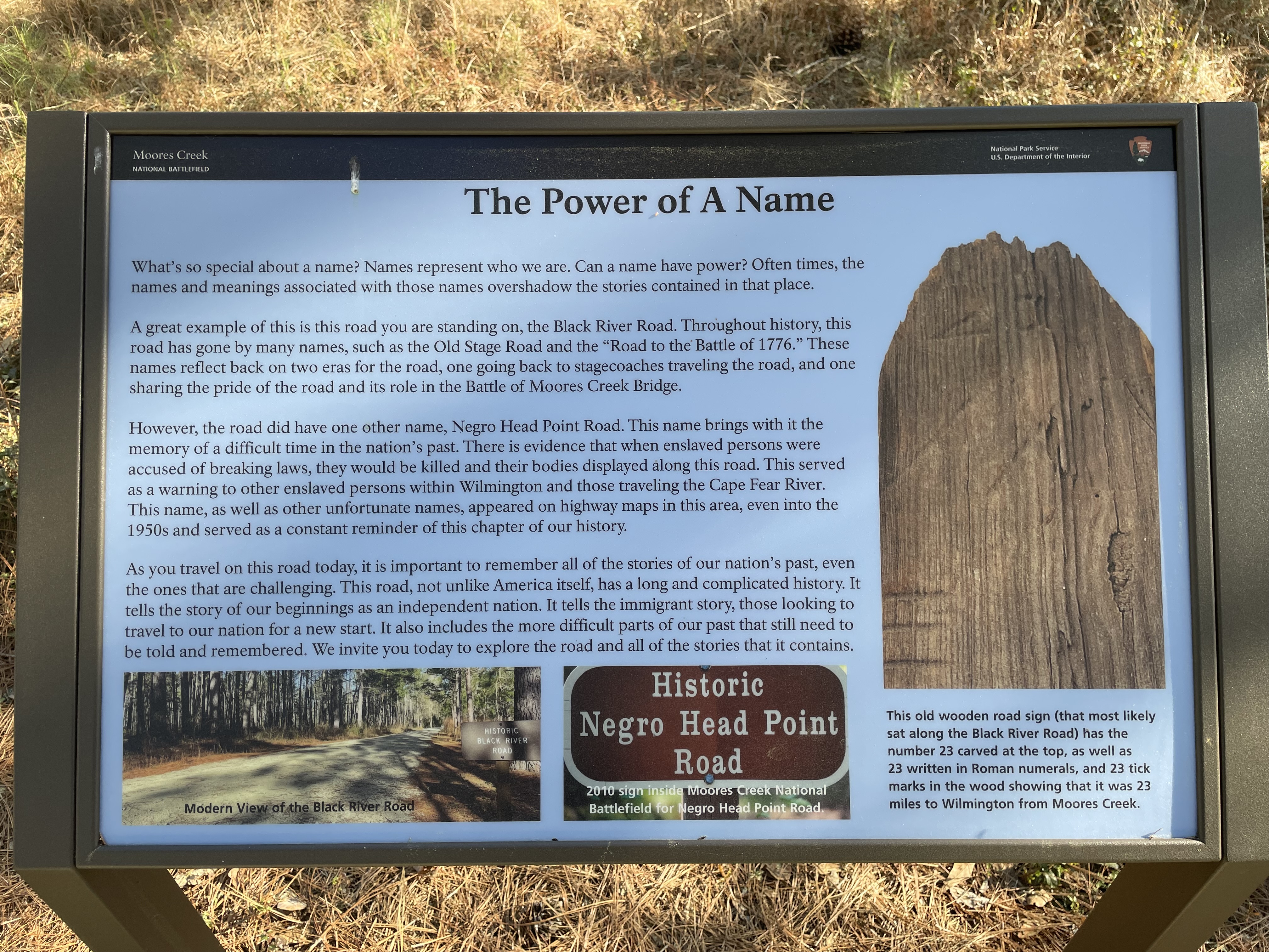
This panel is on the side of the wide sand and gravel historic Black River Road. To the right the road ends at the park boundary where Highway 210 runs. You may hear the sound of passing traffic. As you face the panel, the park entrance road lies a few yards beyond. Behind you is the end of the Woodpecker Trail, a wide sandy path through the open pine woods. To your left, the Black River Road continues through the edge of the woods, running parallel to the park entrance road. Text on the left of the panel reads, "What's so special about a name? Names represent who we are. Can a name have power? Often times, the names and meanings associated with those names overshadow the stories contained in that place. A great example of this is this road you are standing on, the Black River Road. Throughout history, this road has gone by many names, such as the Old Stage Road and the "Road to the Battle of 1776." These names reflect back on two eras for the road, one going back to stagecoaches traveling the road, and one sharing the pride of the road and its role in the Battle of Moores Creek Bridge. "However, the road did have one other name, Negro Head Point Road. This name brings with it the memory of a difficult time in the nation's past. There is evidence that when enslaved persons were accused of breaking laws, they would be killed and their bodies displayed along this road. This served as a warning to other enslaved persons within Wilmington and those traveling the Cape Fear River. This name, as well as other unfortunate names, appeared on highway maps in this area, even into the 1950s and served as a constant reminder of this chapter of our history. "As you travel on this road today, it is important to remember all of the stories of our nation's past, even the ones that are challenging. This road, not unlike America itself, has a long and complicated history. It tells the story of our beginnings as an independent nation. It tells the immigrant story, those looking to travel to our nation for a new start. It also includes the more difficult parts of our past that still need to be told and remembered. We invite you today to explore the road and all of the stories that it contains." At the bottom of the panel are two photographs. The one on the left has a view down the modern Black River Road looking much like the view down the road to your left. The right photograph shows a road sign that reads, "Historic Negro head Point Road." The caption reads, "2010 sign inside Moores Creek National Battlefield for Negro Head Point Road." Down the right side of the panel is a photograph of a weathered wooden plank with an angled top. Near the top the number 23 has been carved. Other carvings are present but difficult to read. Down the left side are several horizontal lines. Text below the photo reads, "This old wooden road sign (that most likely sat along the Black River Road) has the number 23 carved at the top, as well as 23 written in Roman numerals, and 23 tick marks in the wood showing that it was 23 miles to Wilmington from Moores Creek." End of Description.
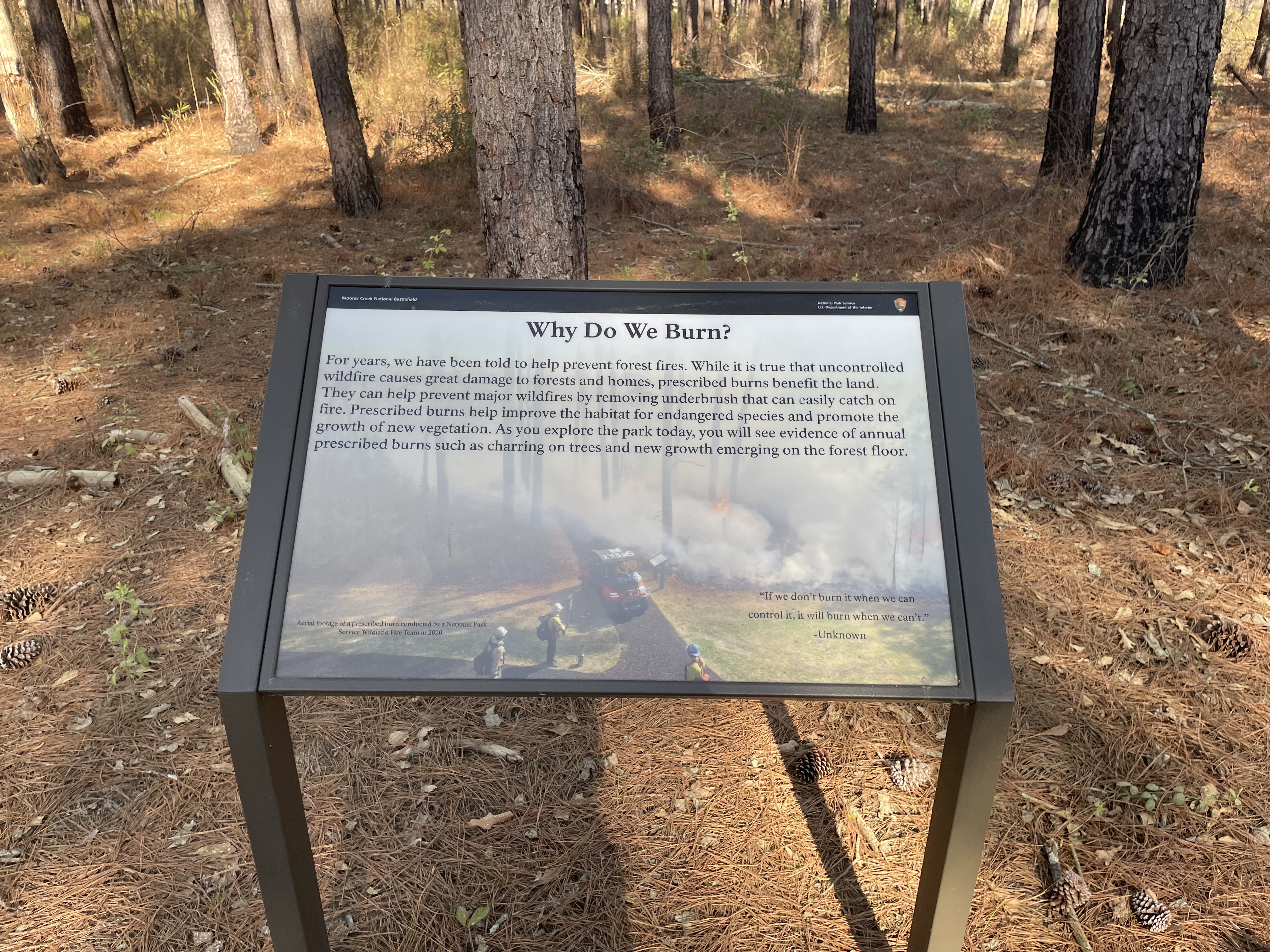
This panel is on the side of the wide sandy trail. A few yards to the right the trail ends at the Black River Road. Behind you as you face the panel, on the other side of the path, is a bench. Beside it is a trashcan. A narrow band of woods separates the bench and the path from Highway 210, so you may hear traffic going by. The open woods beyond the panel has very low undergrowth. The bark on the tree trunks is black near the base. The background of the panel has a ghosted photograph with a bird's eye view of one of the paved paths through the woods. Smoke rises from the forest floor. A small work vehicle sits on the path and workers wearing hard hats stand nearby. The caption at lower left reads, “Aerial footage of a prescribed burn conducted by a National Park Service Wildland Fire Team in 2020.” A quote from an unknown source down the lower right reads, "If we don't burn it when we can control it, it will burn when we can't." Text across the top of the panel reads, " For years, we have been told to help prevent forest fires. While it is true that uncontrolled wildfire causes great damage to forests and homes, prescribed burns benefit the land. They can help prevent major wildfires by removing underbrush that can easily catch on fire. Prescribed burns help improve the habitat for endangered species and promote the growth of new vegetation. As you explore the park today, you will see evidence of annual prescribed burns such as charring on trees and new growth emerging on the forest floor." End of Description.
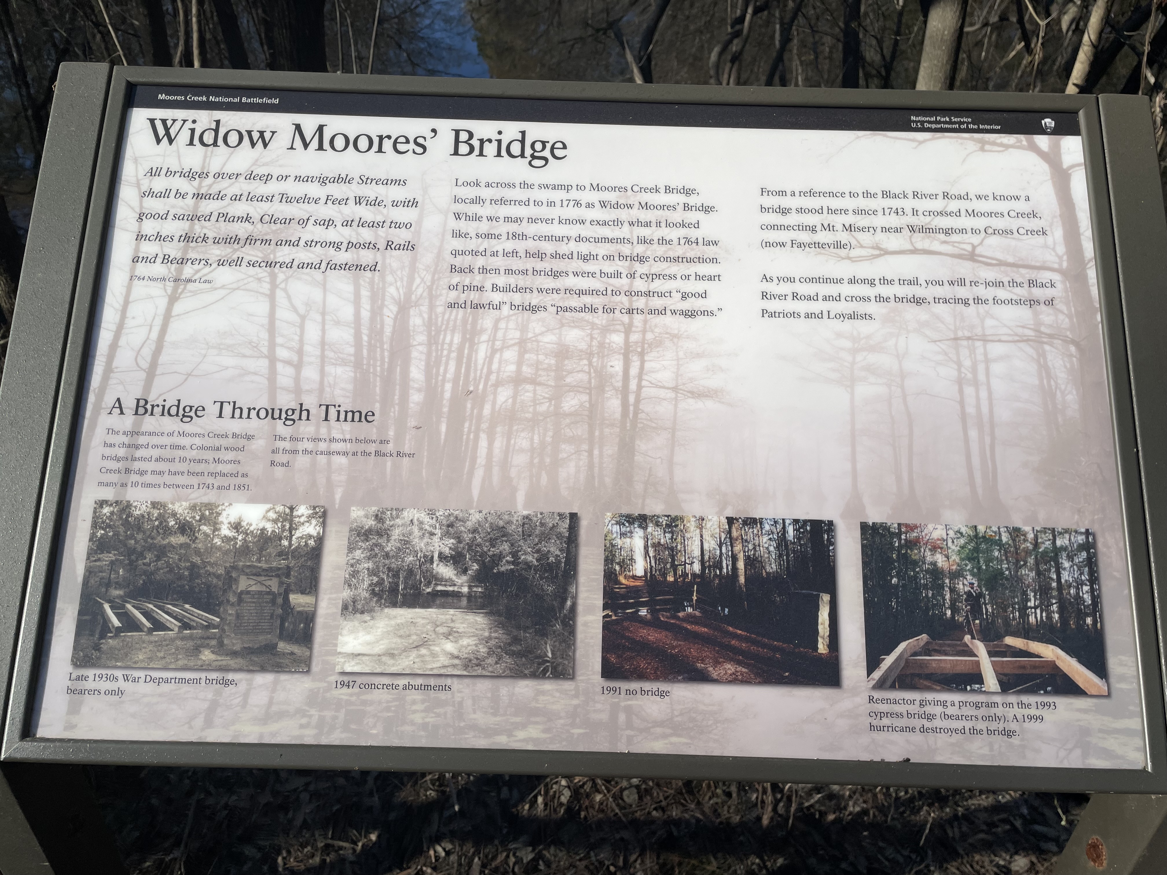
This panel sits on the railing on the left side of the boardwalk as you come from the Visitor Center. Over the top of the panel is a good side view of the bridge over the creek. This end of the boardwalk crosses swampy area along the north side of the creek. Vegetation is thick and includes cypress trees. On the opposite railing is a bench. A few yards past the panel the boardwalk ends and you return to a paved path. There is text across the top of the panel. At the left end is a quote from a 1764 North Carolina law which reads, "All bridges over deep or navigable Streams shall be made at least Twelve Feet Wide, with good sawed Plank, Clear of sap, at least two inches thick with firm and strong posts, Rails and Bearers, well secured and fastened." Continuing across the top of the panel text reads, "Look across the swamp to Moores Creek Bridge, locally referred to in 1776 as Widow Moores' Bridge. While we may never know exactly what it looked like, some 18th-century documents, like the 1764 law quoted at left, help shed light on bridge construction. Back then most bridges were built of cypress or heart of pine. Builders were required to construct "good and lawful" bridges "passable for carts and waggons." From a reference to the Black River Road, we know a bridge stood here since 1743. It crossed Moores Creek, connecting Mt. Misery near Wilmington to Cross Creek (now Fayetteville). As you continue along the trail, you will re-join the Black River Road and cross the bridge, tracing the footsteps of Patriots and Loyalists." Across the bottom of the panel are four photographs of different phases of the bridge in the twentieth century. Text above them reads, "A Bridge Through Time. The appearance of Moores Creek Bridge has changed over time. Colonial wood bridges lasted about 10 years; Moores Creek Bridge may have been replaced as many as 10 times between 1743 and 1851. The four views shown below are all from the causeway at the Black River Road." Beginning at the left the first photograph shows a structure across the creek with only the support beams of wood, no flooring. At right on the near bank is a stone monument. The caption reads, "Late 1930s War Department Bridge, bearers only." The next photo shows the view across the creek with no bridge, only concrete structures on either bank. The caption reads, "1947 concrete abutments." The third photo shows a view across the creek with a rail fence blocking the path. The stone monument sits at right. The caption reads, "1991, no bridge." The last photo shows a view of a wood structure across the creek with three beams extending across the water with two cross supports below. A man wearing a kilt, jacket, and beret stands on one of the beams. The caption reads, "Reenactor giving a program on the 1993 cypress bridge (bearers only). A 1999 hurricane destroyed the bridge." End of Description.
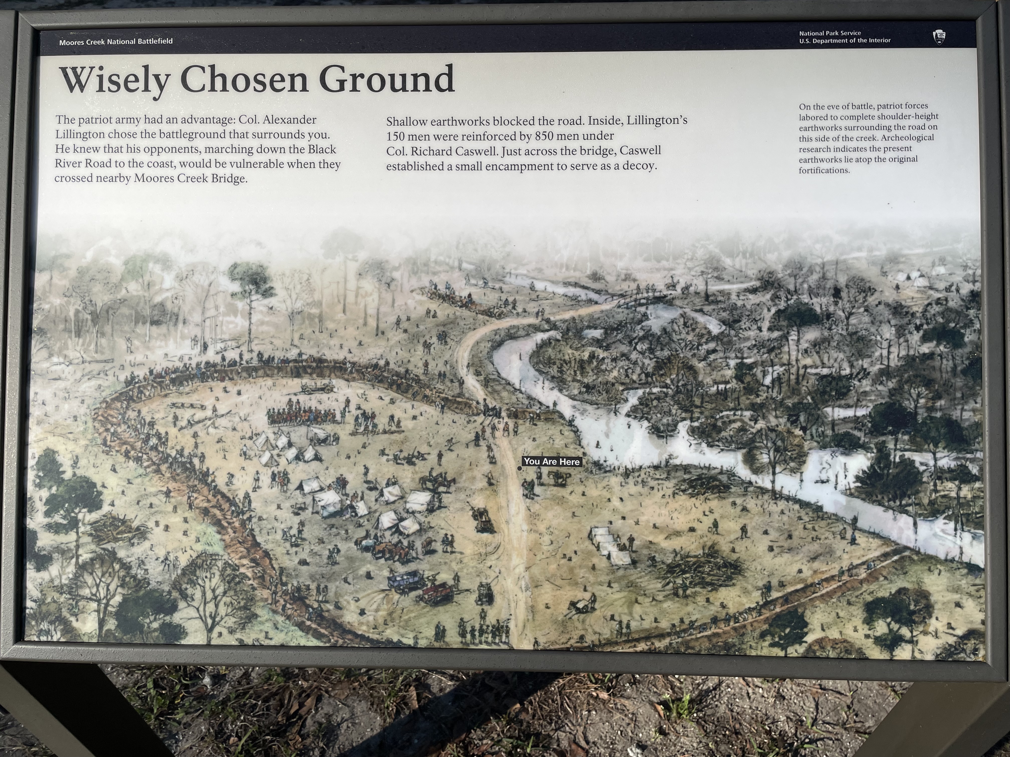
This panel sits along the paved path north of the Black River Road. This is an open area with the swampy creek to the right and the remains of the Patriot's earthen embankment circling behind you, to the left, and in front of you. The road passes though the embankment behind you and exits in front of you where it continues to the bridge. There are a few scattered trees in this area. The path continues to the left where there is another panel and then a boardwalk over the creek. Text across the top of the panel reads, "The patriot army had an advantage: Colonel Alexander Lillington chose the battleground that surrounds you. He knew that his opponents, marching down the Black River Road to the coast, would be vulnerable when they crossed nearby Moores Creek Bridge. Shallow earthworks blocked the road. Inside, Lillington's 150 men were reinforced by 850 men under Colonel Richard Caswell. Just across the bridge, Caswell established a small encampment to serve as a decoy. On the eve of battle, patriot forces labored to complete shoulder-height earthworks surrounding the road on this side of the creek. Archeological research indicates the present earthworks lie atop the original fortifications." The rest of the panel is filled with a color illustration with a bird's eye view of the area. The creek winds along the left side, curving toward the upper center, then back to the left. The earthworks start at the creek in the lower right, circle around toward the upper left, then curves back the creek again. The road splits the area from bottom to top, then curve to the right to cross the bridge over the creek. At the far upper right a small camp with several white tents can be seen. Many men can be seen working to build the earthworks, digging a ditch on the inside and piling the dirt on the perimeter. Inside the area are a dozen white tents on the left side of the road and another four on the right. Several wagons dot the area. Men scatter in the area inside working at various tasks. One group on horseback form a line at upper left. A "You are here" label marks your current location to the right of the road about halfway between the places where it cuts through the earthworks. End of Description.
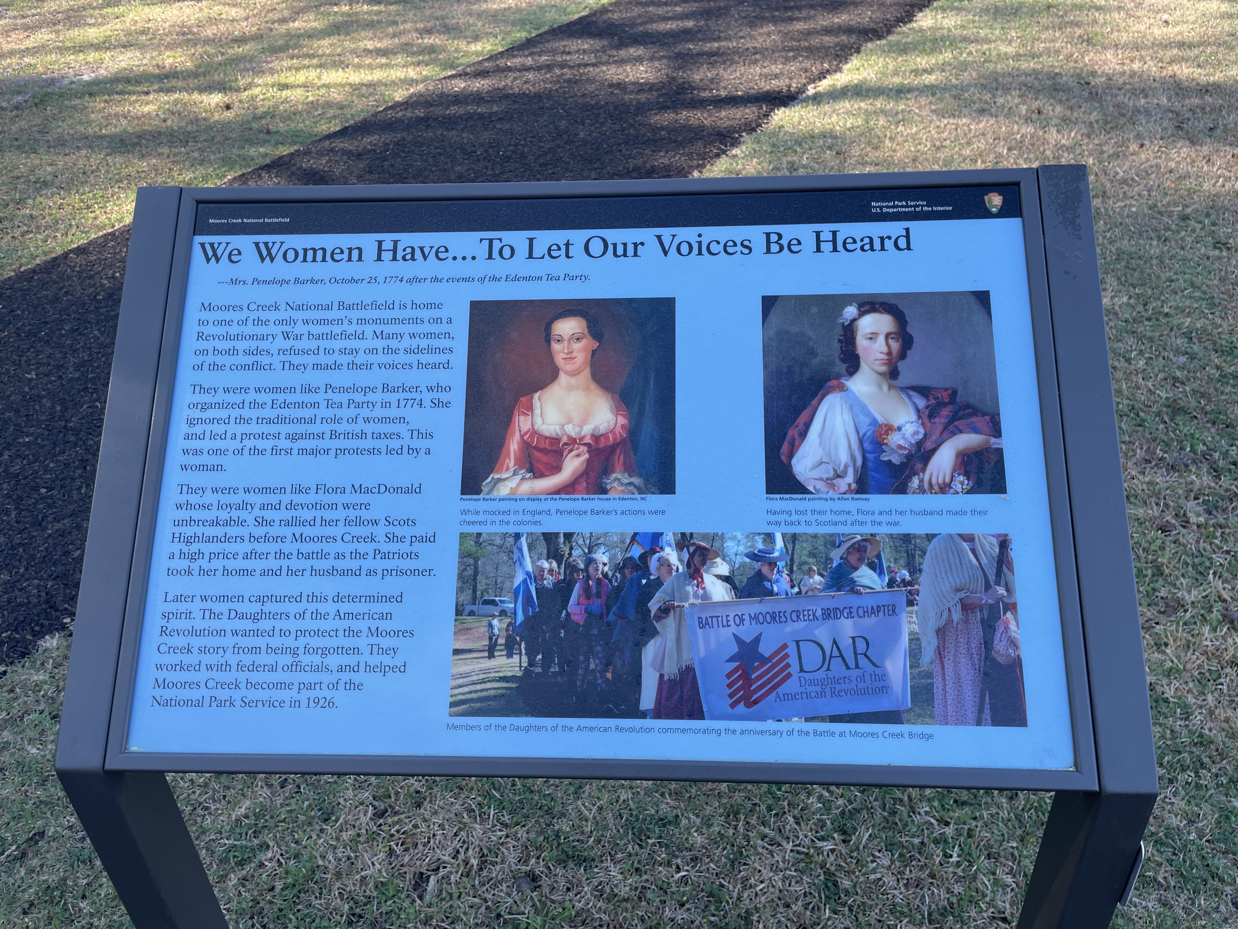
This monument sits on top of a small hill at the end of a short path off of the History Trail. Behind the monument is a bench and an audio station. In front is a grassy rectangle with white stone markers at the head and foot of two graves. The left marker reads, "In memory of Colonel Ezekiel Slocumb, a Patriot of the Revolution, who departed this life July 4th, 1840, aged 80 years and 16 days." The right marker reads, "In memory of Polly Slocumb, wife of Ezekiel Slocumb, who departed this life March 6th, 1836, aged 26 years and 24 days." The monument has a statue of a woman on top of a tall gray stone base. The figure wears a long robe wrapped around her and holds a wreath in her hands. Carved text on the front of the monument reads, "To the honored memory of the heroic women of the lower Cape Fear during the American Revolution, 1775-1781." Text on the right side reads, "Unswerving in devotion, self-sacrificing in loyalty to the cause of their country, their works do follow them, and their children rise up and call them blessed." Text on the back reads, "This monument was erected by the Moore's Creek Monumental Association in the year 1907." Text on the left side reads, "Most honored of the names recorded by this historic association, is that of Mary Slocumb, wife of Lieutenant Slocumb. Riding alone at night sixty-five miles to succor the wounded on this battlefield. Her heroism and self-sacrifice place her high on the pages of history and should awaken in successive generations, true patriotism and love of country. Virtutes majorum filiae conservant." Feel free to touch! The audio station beside the bench behind the monument has six push buttons that activate the different audio stories. There are three buttons down the left side and three down the right. From top to bottom on the left the audio segments are titled "Mary Slocumb's Ride," "Flora McDonald," and "Flora and Fauna." The ones down the right correspond to "Women's Monument," "Penelope Barker," and "En Español." This panel sits near an intersection in the paved path. As you face the panel a side path leads up a slight rise to circle the tall Women's monument with a statue of a woman on top. In front of the monument are two graves with white stone markers. Behind the monument is a bench and an audio station. To your right the path leads back down the hill to the battlefield and the creek. To your left and slightly behind you the path continues back to the parking lot at the Visitor Center. Across the top of the panel is a quote from ---Mrs. Penelope Barker, October 25, 1774, after the events of the Edenton Tea Party which reads, "We Women Have...To Let Our Voices Be Heard." Text down the left side of the panel reads, "Moores Creek National Battlefield is home to one of the only women's monuments on a Revolutionary War battlefield. Many women, on both sides, refused to stay on the sidelines of the conflict. They made their voices heard. "They were women like Penelope Barker, who organized the Edenton Tea Party in 1774. She ignored the traditional role of women, and led a protest against British taxes. This was one of the first major protests led by a woman. They were women like Flora MacDonald whose loyalty and devotion were unbreakable. She rallied her fellow Scots Highlanders before Moores Creek. She paid a high price after the battle as the Patriots took her home and her husband as prisoner. Later women captured this determined spirit. The Daughters of the American Revolution wanted to protect the Moores Creek story from being forgotten. They worked with federal officials, and helped Moores Creek become part of the National Park Service in 1926." To the left of the text are three images, two portraits across the top and a photograph below. The left portrait shows a Penelope Barker painting on display at the Penelope Barker house in Edenton, North Carolina. The woman has black hair pulled back from here face. She wears a red satin dress with a low square neck and elbow-length sleeves. There is a white fringe around the neckline and the sleeves. The caption reads, "While mocked in England, Penelope Barker's actions were cheered in the colonies." The right portrait is a Flora MacDonald painting by Allan Ramsay. She has wavy brown hair that frames here face and falls down her neck in back. She wears a blue bodice over a white blouse with full sleeves and a red and black tartan wrap over her shoulders. The caption reads, "Having lost their home, Flora and her husband made their way back to Scotland after the war." The bottom photograph shows a column of women dressed in period costumes marching. In front they carry a banner that reads "Battle of Moores Creek Bridge Chapter, DAR, Daughters of the American Revolution." The caption reads, "Members of the Daughters of the American Revolution commemorating the anniversary of the Battle at Moores Creek Bridge." End of Description.
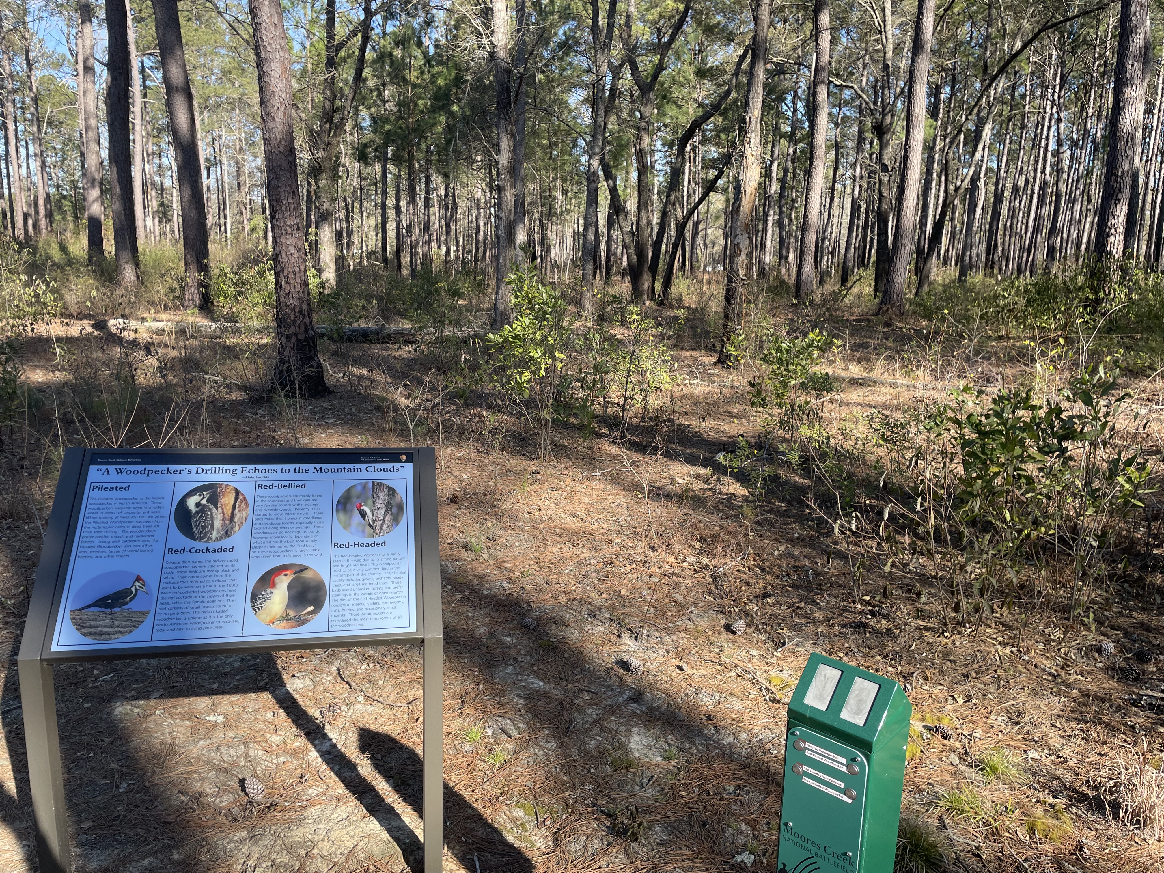
At one side of the wide sandy path here is a small cleared space with the panel at the back edge. All around you are the open pine woods with low undergrowth. As you face the panel, to the right is a bench. Between the panel and the bench is an audio station with four buttons which activate the different audio recordings of woodpeckers, two buttons down the left side and two down the right. From top to bottom on the left the audio segments are "Pileated Woodpecker," and "Red-Headed Woodpecker." The ones down the right correspond to " Red-Bellied Woodpecker," and " Red-Cockaded Woodpecker." Across the top of the panel is a quote from Dakotsu Iida which reads, "A Woodpecker's Drilling Echoes to the Mountain Clouds." Below that the panel is divided into four sections, each describing a different species of woodpecker. Beginning at the left the first is the Pileated Woodpecker. Text reads, "The Pileated Woodpecker is the largest woodpecker in North America. These woodpeckers excavate deep into rotten wood in search of carpenter ant nests. When looking at trees you can see where the Pileated Woodpecker has been from the rectangular holes in dead trees left from their drilling. The woodpeckers prefer conifer, mixed, and hardwood forests. Along with carpenter ants, the Pileated Woodpecker also eats other ants, termites, larvae of wood-boring beetles, and other insects." Below the text is a photo of the pileated woodpecker. It has a black body and wings. Its head tapers to its sharp beak and has black and white stripes running from back to front. It has a bright red crest on top of its head. To the right is the Red-Cockaded Woodpecker. Text reads, "Despite their name, the red-cockaded woodpecker has very little red on its body. These birds are mostly black and white. Their name comes from the cockade that referred to a ribbon that used to be worn on a hat in the 1800s. Male red-cockaded woodpeckers have the red cockade at the crown of their head, while the female does not. Their diet consists of small insects found in or on pine trees. The red-cockaded woodpecker is unique as it is the only North American woodpecker to excavate, roost and nest in living pine trees." Above the text is a photo of the woodpecker. It has black wings speckled with white. Its breast is white speckled with black. Its head is mostly white with a black stripe running from the top of its head, down in front of its eye, and then down to meet the black of its wings. There is a tiny red patch behind its eye. Third is the Red-Bellied Woodpecker. Text reads, "These woodpeckers are mainly found in the southeast and their calls are very familiar sounds within swamps and riverside woods. Recently it has started to move into the north. These birds make their homes in. woodlands and deciduous forests, especially those located along rivers or swamps. These woodpeckers do not migrate, but do however move locally depending on what area has the best food supply. Despite their name, the "red belly" on these woodpeckers is rarely visible when seen from a distance in the wild." Below the text is a photo of the bird. It has a white head, throat, and chest. Its wing is black and white speckled. A red band runs across the top of its head from the black beak to its back. Very low on its belly is a faint red patch. The last woodpecker is the Red-Headed Woodpecker. Text reads, "The Red-Headed Woodpecker is easily seen in the wild due to its strong pattern and bright red head. This woodpecker used to be a very common bird in the eastern part of the country. Their habitat usually includes groves, orchards, shade trees, and large scattered trees. These birds avoid unbroken forests and prefer clearings in the woods or open country. The diet of the Red Headed Woodpecker consists of insects, spiders, earthworms, nuts, berries, and occasionally small rodents. These woodpeckers are considered the most omnivorous of all the woodpeckers." Above the text is a photo of the bird. It has a white breast and a black wing with a white band near the bottom edge. Its head is entirely red. End of Description.
The Visitor Center is open Tuesday - Saturday, 9:00 am to 5:00 pm. This includes access to exhibits, the park's 10-minute film, "In the Most Furious Manner", the gift shop, and America the Beautiful Military and Access Passes. We do not sell the Annual or Senior Passes. Although the Visitor Center is closed on Sunday and Monday, the trailhead kiosk remains open for visitors to procure basic information and stamp their National Park Service Passport. The Visitor Center phone number is 910-283-5591.
Moores Creek National Battlefield Self-Guided Tour
Explore the site of the first decisive Patriot victory of the American Revolution at Moores Creek. Take a walk through the Patriot earthworks and across Moores Creek Bridge to learn more about this important struggle. Along the way, you will see six monuments that share the stories of these men and women who participated in this campaign.