Be advised that the NPS has issued alerts for this park.
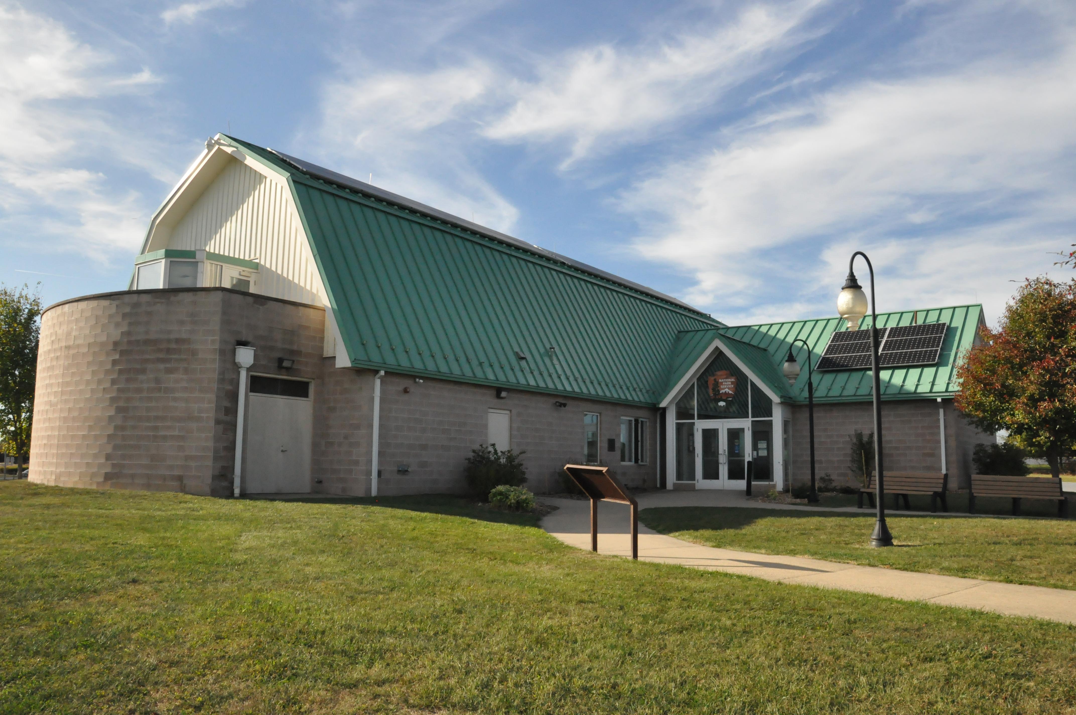
Monocacy National Battlefield Museum Renovations
The visitor center is open to the public during renovations. The museum area inside the visitor center is closed. We apologize for the inconvenience. The museum is expected to reopen in the Fall of 2025. Please watch our social media for updates and announcements regarding the museum renovations.
During the summer of 1864, the Confederacy carried out a bold plan to turn the tide of the Civil War in their favor. They planned to capture Washington, DC and influence the election of 1864. On July 9, however, Federal soldiers outnumbered three...
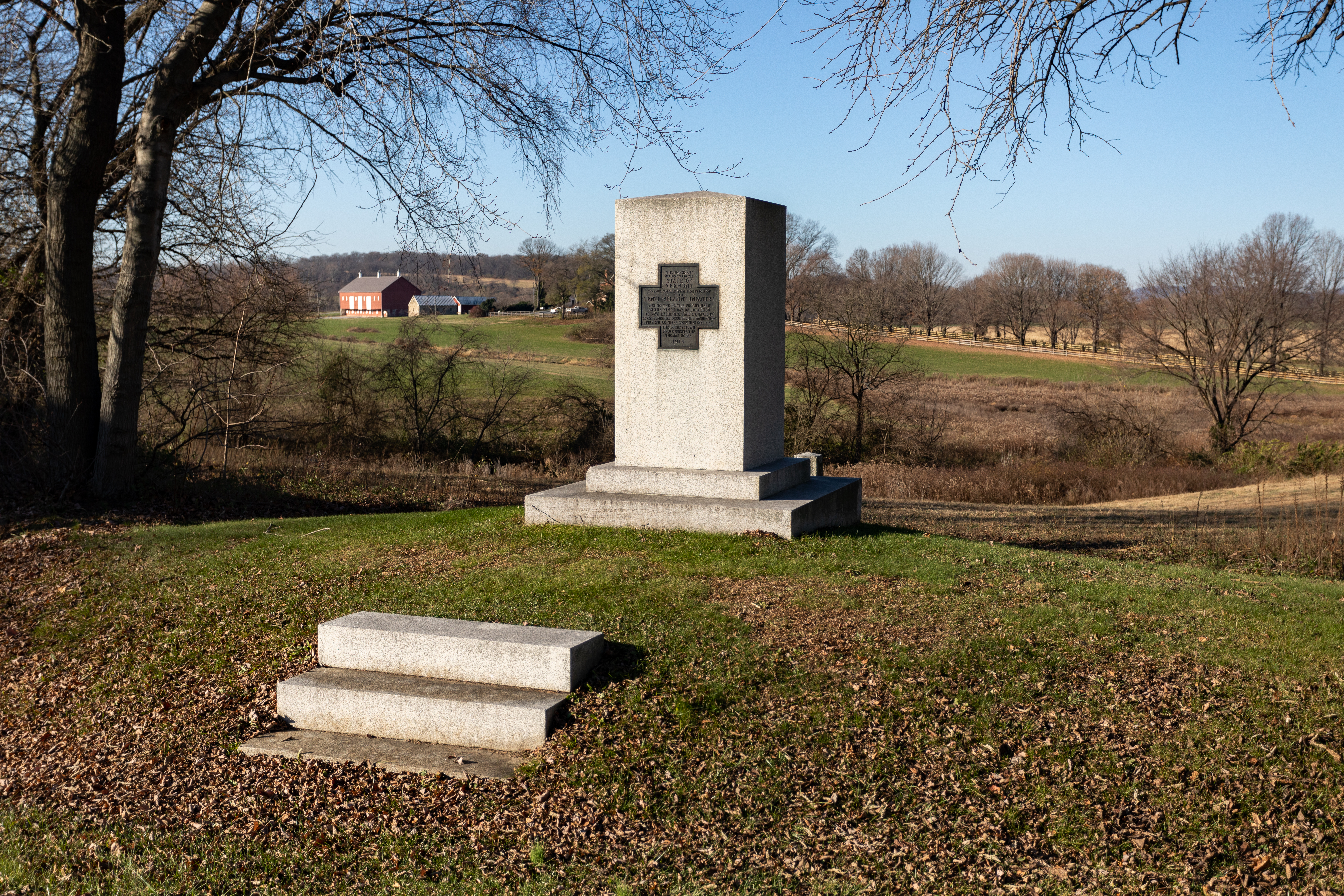
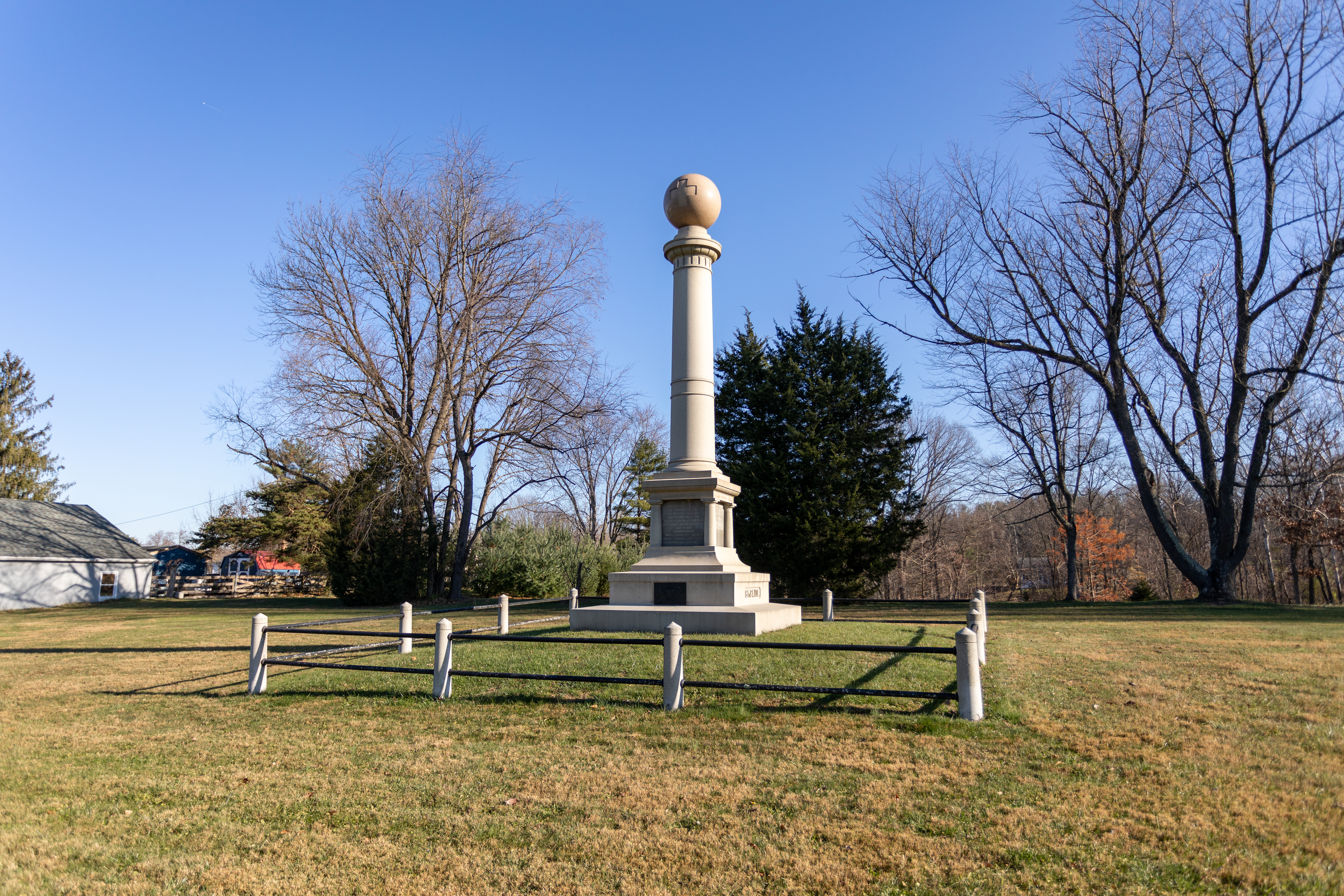
The 10th Vermont Monument was dedicated in 1915 by the State of Vermont to honor the 10th Vermont infantry Regiment. This monument was the fourth erected at Monocacy.
This description 355 words in length. The Vermont Monument at Monocacy National Battlefield is located four miles south of Frederick, Maryland, at the northwest corner of the T-shaped intersection of Araby Church Road and Baker Valley Road. There is a small car pull-off near the monument. The monument is a light-gray granite monolith approximately seven feet in height, 3 feet wide, and 3 feet deep. The surface of the granite is smooth. The monument faces southeast towards the intersection. There are three granite steps leading up to monument. On the front it has a 1.85 foot by 1.85 foot bronze tablet in the shape of a Greek Cross, the symbol of the 6th Corps. The tablet is inscribed: This monument was erected by the STATE OF VERMONT to designate the position of the TENTH VERMONT INFANTRY during the battle fought here on the ninth day of July 1864 to save Washington, "and we saved it." Seven companies occupied the Washington Pike, while three companies occupied the Buckeystown Road opposite the Thomas House. 1915 To the north of the monument is the Thomas Farm. Fields of crops with trees at the edges abut the monument. Approximately a quarter of a mile northwest of the monument is a brick farm house, a stone tenant house and a red barn. Baker Valley Road runs to the west of the monument. It is a narrow, two-lane road. On the north side of Baker Valley Road is the battlefield. On the south side of Baker Valley Road are seven private homes. There is a gentle rise to Baker Valley Road as it moves to the west. To the south of the monument, immediately on the corner of Baker Valley Road and Araby Church Road is a small red brick church, Araby United Methodist Church. It has three stained glass windows on the north side of the building. The entrance is on the east end of the building. To the east of the monument Baker Valley Road meets at a T-intersection with the narrow, two-lane Araby Church Road. Across the road is a mowed grass field. One-hundred-sixty feet northeast of the Vermont Monument is the Pennsylvania Monument.
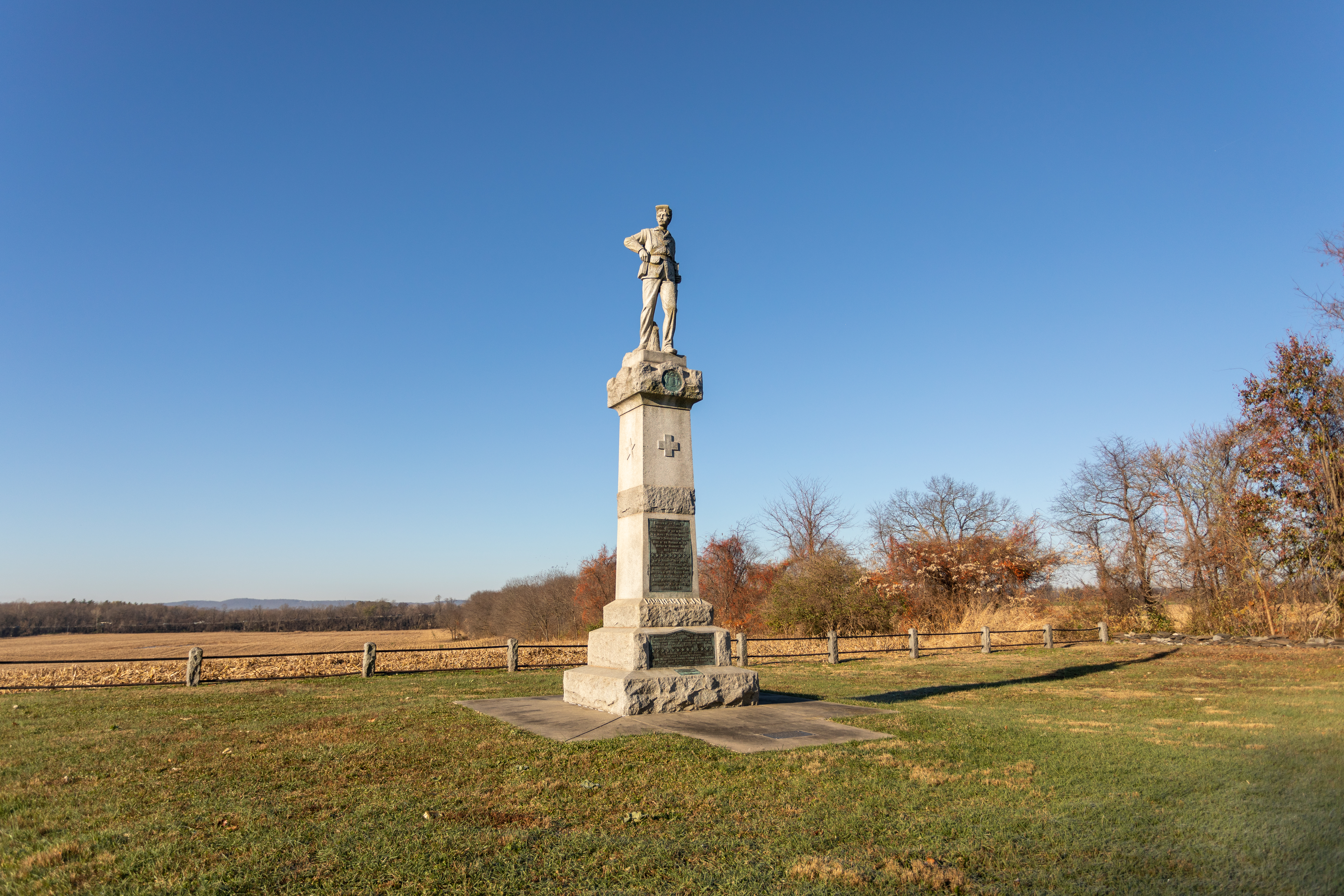
Dedicated on July 9, 1907, the 14th New Jersey Monument was the first Civil War monument erected at Monocacy Junction. The State of New Jersey commissioned the monument in honor of the soldiers of the 14th New Jersey Regiment for the their dedicated service and sacrifice throughout the Civil War.
This description is 660 words long. The 14th New Jersey Monument is 24 feet tall with a sculptured granite full-length figure of a uniformed Union Army infantryman standing on a tall pedestal on a three-tiered rough-hewn base. The monument grounds are enclosed in stone-pillared iron fence. The statue of the infantryman is seven feet tall. He is standing facing the East. His head is turned 45 degrees to his right, looking South into the distance. His mustache curls up on the sides. He wears a Union soldier’s field uniform: McClellan cap, a hip-length coat with a belt over it at the waist, trousers, and shoes. He has pouches hanging from crossed shoulder straps and his belt. His right hand is at his waist reaching into his ammunition pouch, and his left hand holds the barrel of his musket upright, the butt at his left foot. His left leg is slightly bent. The statue is at the top of a 17-foot tall square column. The width and the texture of the column varies as it moves from top to bottom. Immediately below the statue is a smooth band about a foot thick. A rough finished band about two feet thick protrudes from the column below it. On the East side of the band is a round bronze plaque, the seal of the State of New Jersey. The next segment of the column is smooth and about six feet long. Centered on all four sides of this section is a raised Greek Cross, the emblem of the 6th Corps. Below this section is a rough finished band about 2 feet thick, followed by another six-feet long smooth section. A bronze plaque almost entirely covers the east face of this section. The bronze plaque reads: "Erected by the State of New Jersey to commemorate the heroic services of the 14th Regiment, New Jersey Volunteer Infantry, 1st Brigade, 3rd Division, 6th Army Corps, Army of the Potomac, at the Battle of Monocacy, MD. July 9, 1804. The 14th Regiment New Jersey Volunteers was organized on the Monmouth Battle Ground, and mustered in the United States service near Freehold, New Jersey August 26th, 1862, and was mustered out June 18th, 1865, near Washington, D.C." The next section of the column is slightly wider and rough finished. The next tier is wider still and has another plaque embedded on its east side. The second plaque reads: "The Union forces commanded by General Lew Wallace on the battlefield so stubbornly opposed the Confederate troops under General Jubal A. Early as to assure the safety of the National Capital. The commission to erect the monument Major John C. Patterson, President Adjutant William H. Foster; Secretary Corporal R. A. Clark, Treasurer Captain Jarvis Wanser Sergeant John Grover Thos Manson & Son, Builders " The next tier is the widest level and serves at the foundation of the column. It is also rough finished. A small plaque is embedded in the horizontal surface of the east side. It reads: "This site rededicated July 5, 1964 Civil War Centennial Commission State of New Jersey Richard J. Hughes Governor" On the east side of the concrete pad surrounding the monument is a fourth bronze plaque: "We commemorate the 100th anniversary of this monument and rededicate it in honor of those who served with pride and distinction in the 14th New Jersey Volunteer Infantry. One hundred years ago, in a time of healing, the surviving veterans came here to remember their comrades and their sacrifices. We gather here today to honor them anew. Their struggle to preserve the Union must never be forgotten. The New Jersey Civil War History Association July 7, 2007" To the north of the monument are railroad tracks. To the west is a farm field that wraps around the south side of the monument. The field is bordered by the Monocacy River on the south. To the East is a two-lane road, the Georgetown or Urbana Pike. Trees screen the monument from the road.
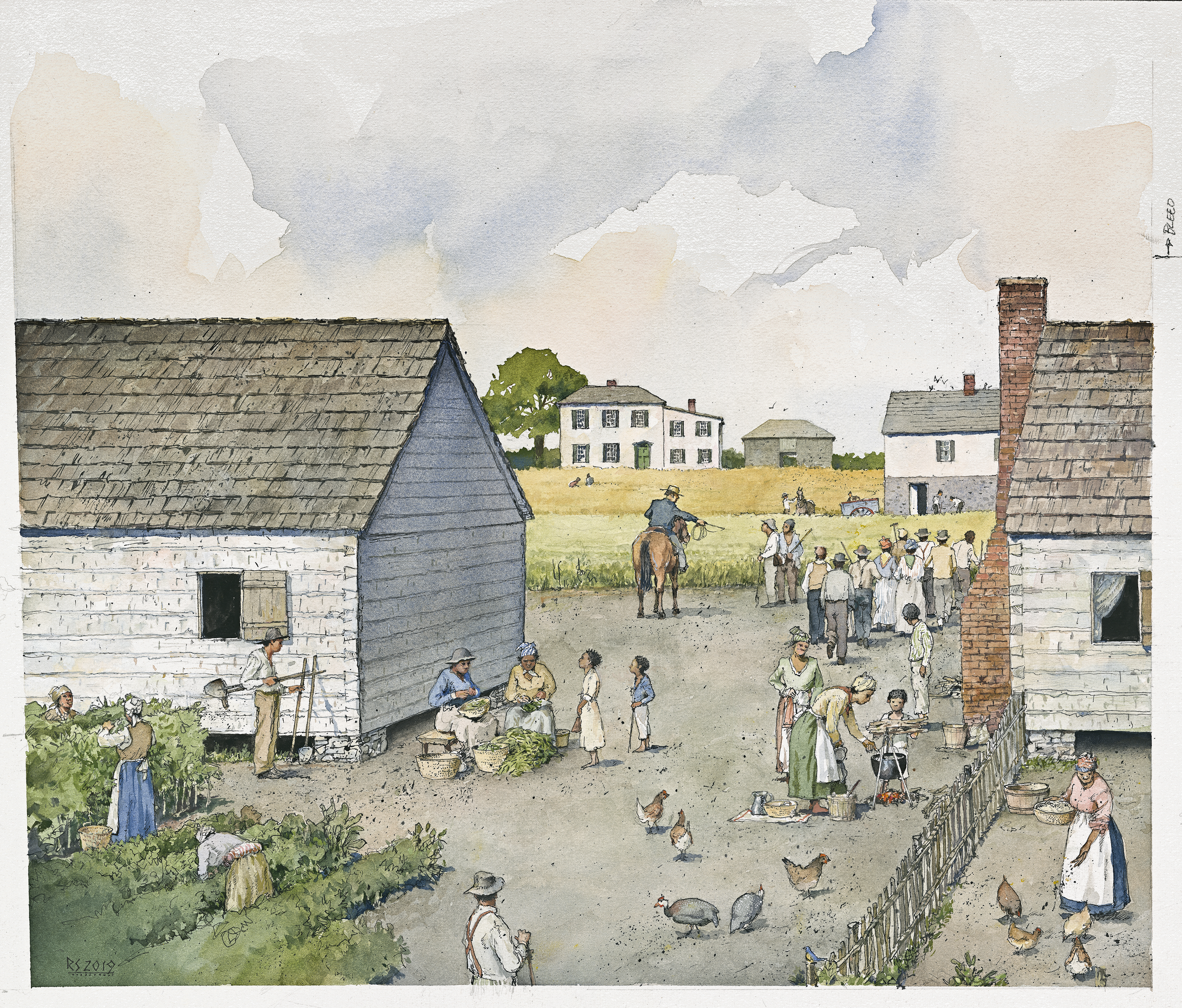
The quiet farm fields of the Best Farm hide deep stories of conflict and struggle. Originally known as L'Hermitage, the French-Caribbean family that sought freedom and safety here enslaved up to 90 people of African descent. During the Civil War, Union and Confederate armies took turns occupying the land; finally clashing here on July 9, 1864. This is tour stop 1 on the driving tour.
This description is 541 words long. The Best Farm is a 274-acres, active farm. It is bordered by the Georgetown Pike on the east, the Monocacy River on the south, Interstate 270 on the west, and an office park on the north. A half-mile-long, gravel, L-shaped lane leads west from the Georgetown Pike back to a cluster of farm buildings. Fields planted with crops flank the farm lane. A tenth of a mile from the Georgetown Pike, there is a break in the cultivated fields south of the lane. Next to the road is a dirt mound about ten-feet high and a swath of grasses extends south to the tree line. At the turn in the lane, there is a grassy path that extends northwest through the farm fields approximately 750-feet to two cannons. Continuing on the gravel lane south leads to a cluster of farm buildings and a parking area. From the parking area, looking north is a field of crops. Turning in a circle to the east there are a cluster of a waysides and a small, two-story house. Turning further south there is a small, white shed; two cannons; a large tree; a large white farmhouse and a small weathered shed; a corn crib. To the west there is a stone barn. Two-hundred-twenty feet east of the parking area is a small (35 by 20 feet), rectangular secondary house. The first floor is stone and the second story is white, German shiplap siding. The roof is a standing seam, red roof. There is a brick chimney in the center of the house and a stone and brick chimney on the northern exterior of the house. Seventy feet southwest of the secondary house, there is a small (8 by 8 feet), white, square shed with a sloped roof. One-hundred, fifty feet west of the shed is the main house. One-hundred, ten feet south of the parking area across a mowed lawn is a large, two-story, white farmhouse with a red, standing seem, metal roof—The Best House. It is L-shaped, with its fifty-foot front facing east toward the Georgetown Pike. The north side of the house tis seventy foot long. The roofline of the front part of the house runs north/south is higher while the roofline of the addition runs east/west. A small, weathered wood shed sits 10 feet west of the back of the addition. Fifty feet northwest of the main house and fifty feet southwest of the parking area is a corn crib. It is a weathered, fifty by thirty feet rectangular, wood structure with a peaked roofline that runs east/west. The roof is a red, metal, standing seam roof. The building has a cutout shaped like an upside down “U” or lowercase “N” that runs east/west through it. The space is twenty feet wide, large enough to drive a truck through. Two-hundred, forty feet west of the corn crib and the parking area, is a stone barn. The barn’s solid stone walls are two-stories tall. The east and west sides of the barn are sixty-feet long with ten-foot wide openings directly across from each other in the center. The north and south ends of the barn are thirty foot long. The barn is capped by a red metal, standing seam, hipped roof.
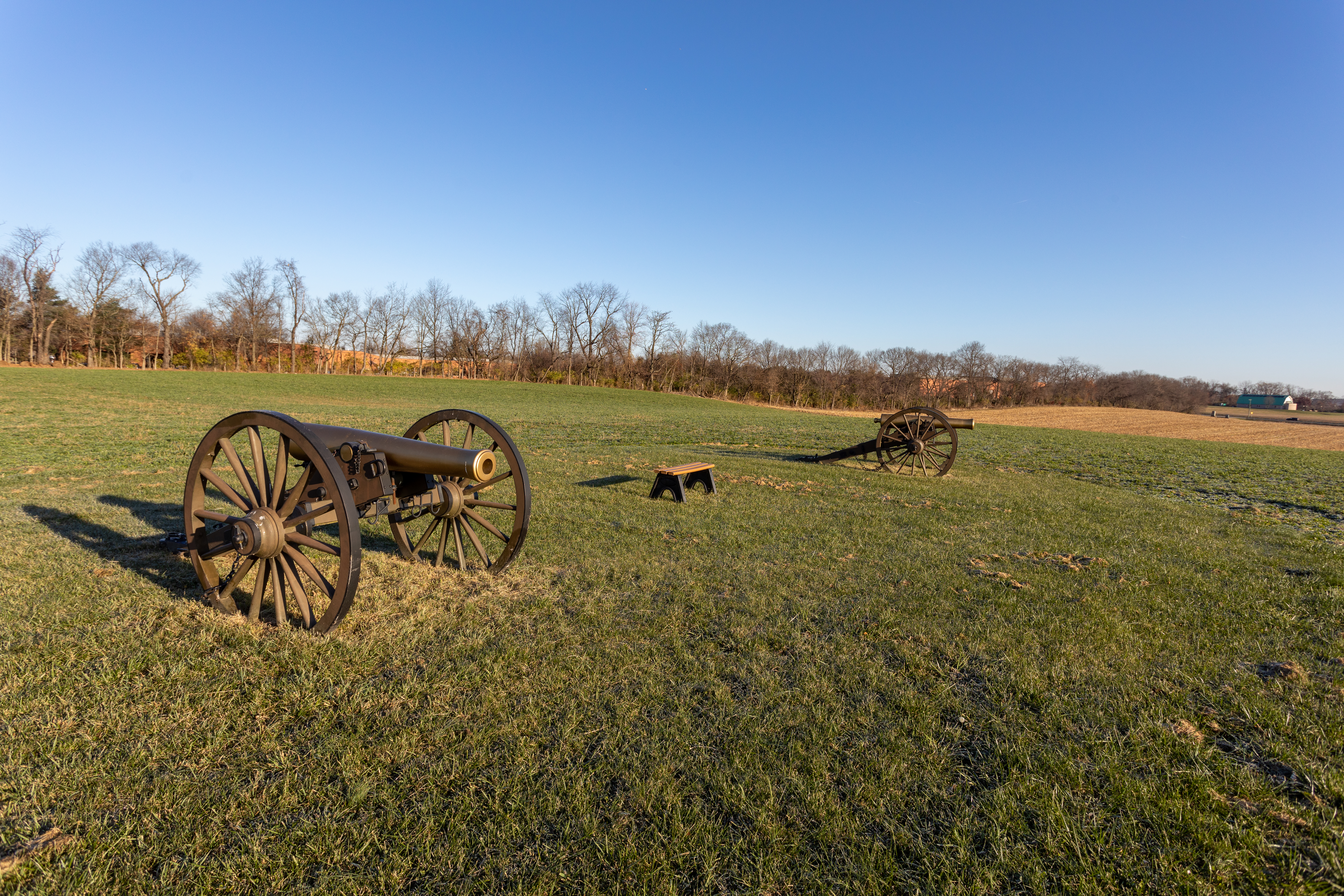
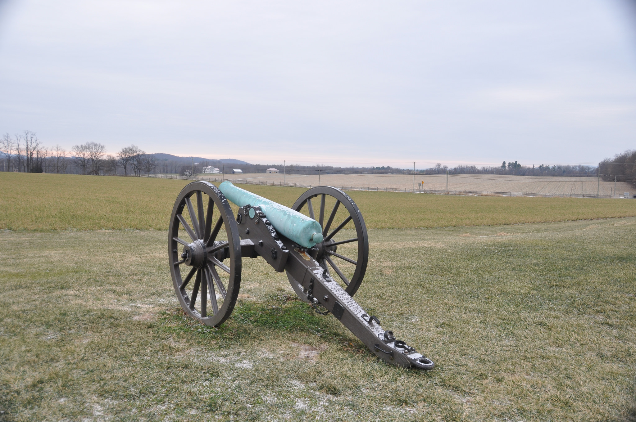
These replica cannon represent the approximate location of Confederate artillery during the Battle of Monocacy.
This description has two hundred words. Two replica cannons are surrounded by farm buildings. The cannon point south. The main house is 85 feet to the west. There is a small shed 20 feet east of the cannon and a small two-story house 90 feet to the northeast. The cannon is a replica 12-pound Napoleon model. The brass barrel of the gun is six feet and seven inches long. At the rear of the barrel is a small knob. The circumference of the barrel tapers as it moves forward to the mouth of the barrel in front. The brass barrel sits on a wooden carriage with two five-foot diameter wheels with wood spokes, one on each side of the barrel. A long wooden stock slopes away from the barrel with its tail resting on the ground. It extends six feet beyond the rear of the barrel. Looking south from the cannon, the lawn extends 100 feet to a line of trees that screen the railroad tracks. To the west, a large tree grows in front of the two-story, white, farmhouse. To the north, a long gravel driveway divides the agricultural fields. To the east beyond the small house is a rolling agricultural field and Route 355.
These replica cannon represent the approximate location of Confederate artillery during the Battle of Monocacy.
This description has 220 words. 700 feet from the trailhead, two replica Civil War cannon sit just off of a mowed trail on a 70 x 40 foot rectangle of grass. The grassy rectangle and trail are surrounded by agricultural fields that grow a variety of crops. The cannon point southeast towards the railroad and road bridges. The cannon are 12-pound Napoleon models. The brass barrel of the gun is six feet and seven inches long. At the rear of the barrel is a small knob. The circumference of the barrel tapers as it moves forward to the mouth of the barrel in front. The brass barrel sits on a wooden carriage with two five-foot diameter wheels with wood spokes, one on each side of the barrel. A long wooden stock slopes away from the barrel with its tail resting on the ground. It extends six feet beyond the rear of the barrel. Looking south from the cannon, 1,300 feet to the south is a cluster of farm buildings. The field has small, rolling changes in elevation across it. Looking west, a line of trees rims the agricultural field and screens Interstate 270. Turning to the north a line of trees rims the agricultural field and screens an office park. The east, the agricultural field is bordered by Urbana Pike (Route 355).
The unusual architecture of the Best Farmhouse hints at its unexpected history. Built by French refugees fleeing the civil unrest of the French and Haitian Revolutions, the style is a mixture of French, Caribbean, and early Federal styles.
This description is 540 words long. One-hundred, ten feet south of the parking area across a mowed lawn is a large, two-story, white farmhouse with a red, standing seem, metal roof—The Best House. It is L-shaped, with its fifty-foot front facing east toward the Georgetown Pike. The front section of the house is covered in stucco and painted white. The front or east elevation has five bays with a central entrance. A small gabled, entrance porch leads to the front door which is centered with two six-over-six-pane windows on each side of it. There are five six-over-six-pane windows on the second floor. The windows to the south of door are set slightly higher than the windows to the north of the door, indicating that the south and north portions of the house were built at different times. The seventy foot long, north side of the house transitions from the stucco on the eastern portion of the house to an addition with white, German shiplap siding on the western section. The roofline of the front part of the house runs north/south and is higher while the roofline of the western addition runs east/west. The north elevation of the front part of the house has three rows of two windows, revealing a third floor. The addition has two doors in the center with 12-pane windows on the outside. The second story has four 12 pane windows, placed above the windows and doors on the first floor. A small, weathered wood smokehouse sits 10 feet west of the back of the addition. The four distinct rooflines and widths visible from the south and west elevations reveal how the house grew overtime. The roofline of the front (eastern) section of the house is broader and higher on the northern half. The chimney in the northern section extends from the roof ridge. The chimney on the southern section of the house is on the western exterior wall. Windows on the southern section also vary in height and size from the northern section. The southern section has two bays on its southern elevation. On the second floor there are two windows. On the first floor this a window on the north and door on the south bay. Slanted doors under the north bay reveal a cellar entrance. The west elevation of this section has two windows (one above the other) south of the chimney and a single window in the middle of the elevation north of the chimney. The wider northern section of the house has a south elevation with two windows (one above the other). The western addition also reveals two sections different widths and variations in chimney placements. The center section has a chimney centered on its southern wall. There are two windows at the east end of this center section and a door on the first floor at the west end of the section. The west section of the house is about two feet narrower than the center section. It has two windows (one above the other) on the south elevation. The chimney is centered on the western wall and emerges at the roofline. There are small windows, one on each side of the chimney, in the gable on this west elevation.
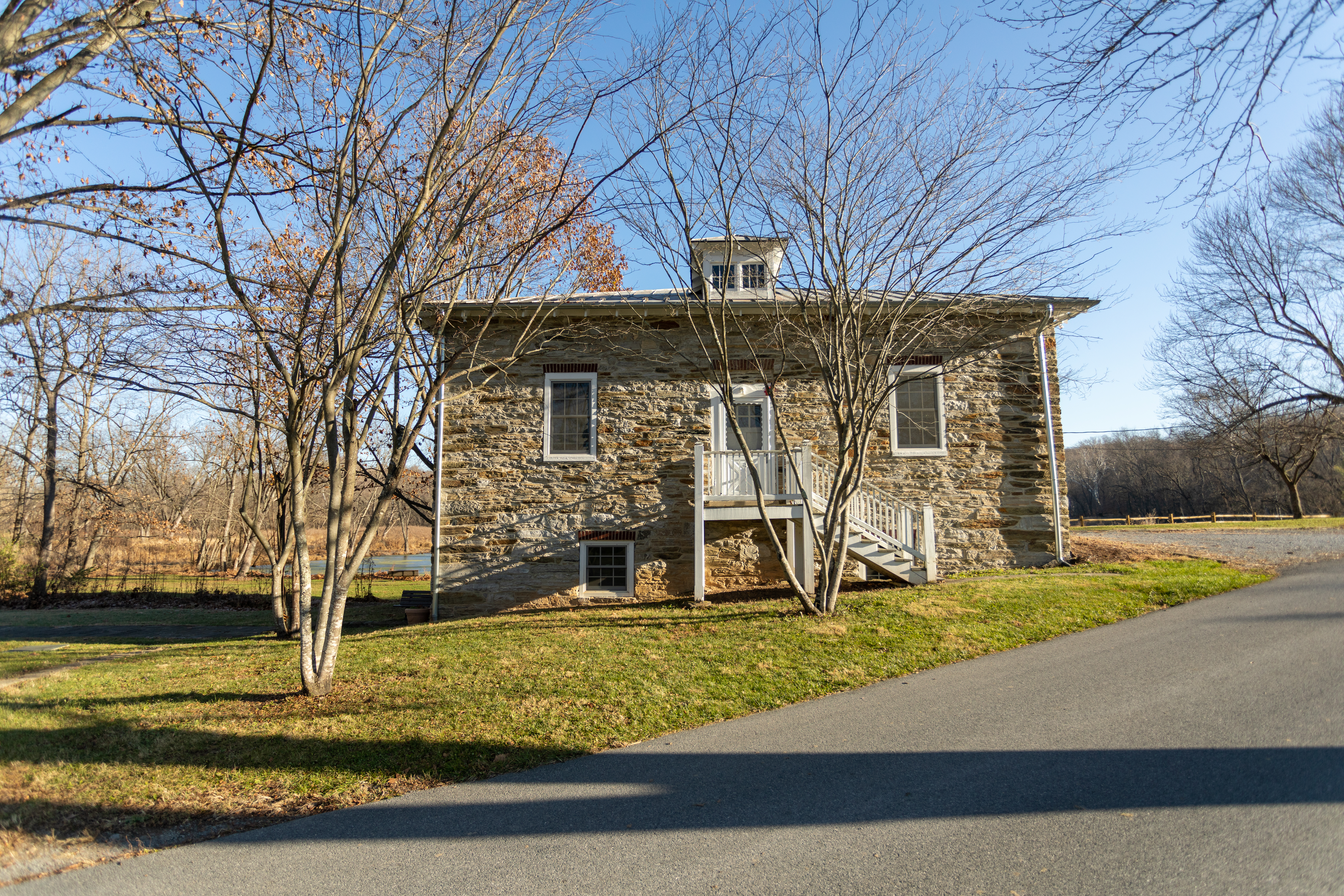
Smaller and less grand than the neighboring main house, the Secondary House on is probably the oldest existing structure on the Best Farm. Evidence suggests it has primarily served as a tenant house throughout its existence.
This description is 170 words. The Secondary House is a eighteen by thirty-six feet rectangular house. The first floor is made of neatly laid local limestone. The second story has white, German shiplap wood siding. The roof is a standing seam, red roof. There is a brick chimney in the center of the house and a stone and brick chimney on the northern exterior of the house. On the west elevation of the building there are no windows or doors on the first-floor and two shuttered windows and a door on the second floor. There are no stairs to access the door. On the north elevation of the house is the exterior stone and brick chimney and two small, shuttered windows (one on each level). On the east elevation, there are two doors on the first floor and two small, shuttered windows on the second level. On the south face there are three larger, shuttered windows: one on the first floor, one on the second, and one in the peak of the roof.
The battle had been raging for almost six hours when around 2 pm McLaughlin's battery of Confederate artillery was brought across the Worthington-McKinney Ford to support Gordon's attack.
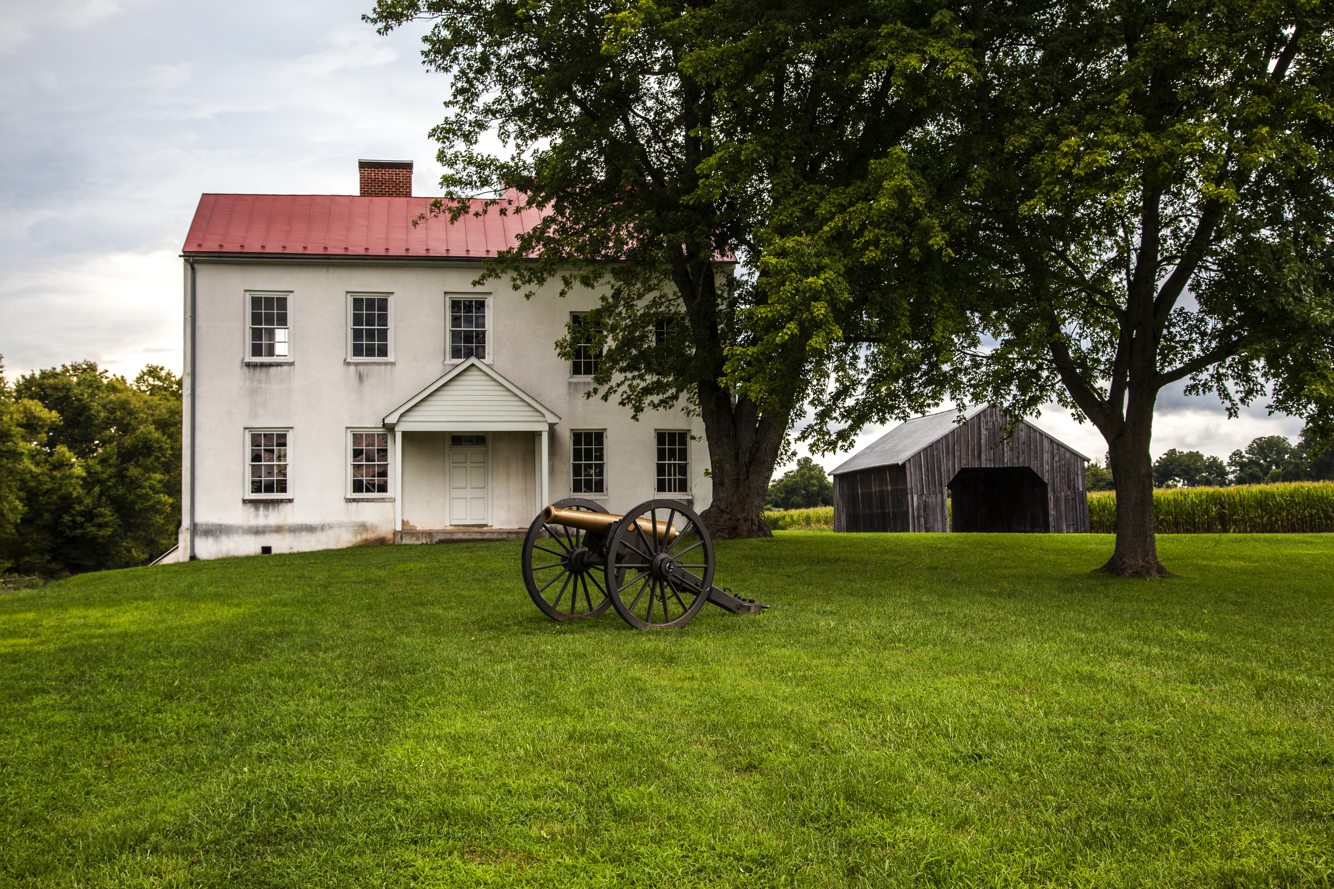
A cannon sits just south of a two-story, red, brick farmhouse. The cannon is a reproduction 12-pound Napoleon model. The brass barrel of the gun is six feet seven inches long. At the rear of the barrel is a small knob. The circumference of the barrel tapers as it moves forward to the mouth of the barrel in front. The brass barrel sits on a wooden carriage with two five-foot diameter wheels with wood spokes, one on each side of the barrel. A long wooden stock slopes away from the barrel with its tail resting on the ground. It extends six feet beyond the rear of the barrel.
Two replica cannon mark the approximate location of Confederate artillery during the Battle of Monocacy.
This description has 200 words. Two replica cannons sit in an agricultural field. The cannon point southwest towards the railroad junction and the Monocacy River. The parking lot and Visitor Center are approximately 80 feet to the north. Urbana Pike (Route 355) is 700 feet to the west. The cannon are 12-pound Napoleon models. The brass barrel of the gun is six feet and seven inches long. At the rear of the barrel is a small knob. The circumference of the barrel tapers as it moves forward to the mouth of the barrel in front. The brass barrel sits on a wooden carriage with two five-foot diameter wheels with wood spokes, one on each side of the barrel. A long wooden stock slopes away from the barrel with its tail resting on the ground. It extends six feet beyond the rear of the barrel. Looking south from the cannon, the field extends for about half a mile. The field has small, rolling changes in elevation across it. Across the river, about a mile away, tree covered hills are visible. Looking west, the Best Farm continues on the other side of Urbana Pike. A white house and other smaller buildings sit to the southwest about a half mile from the cannon.
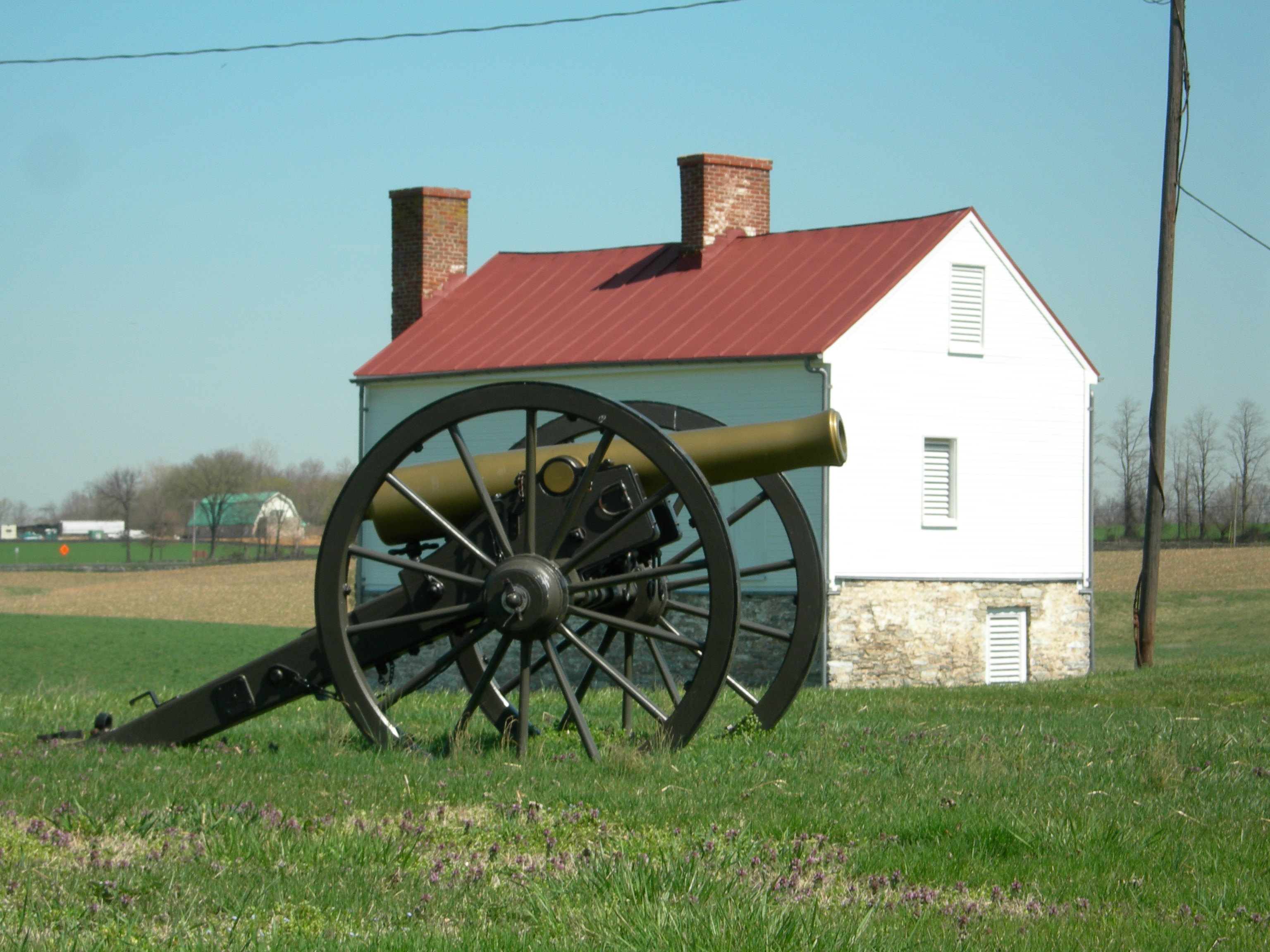
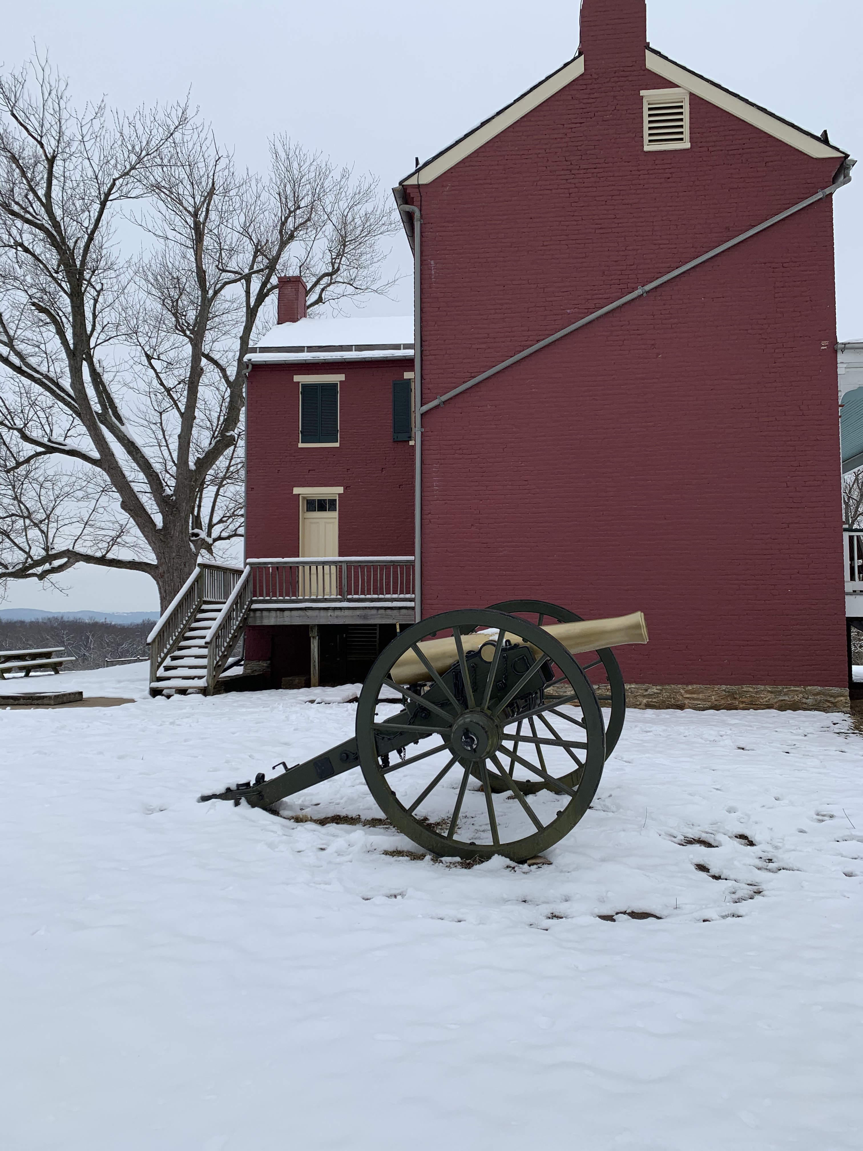
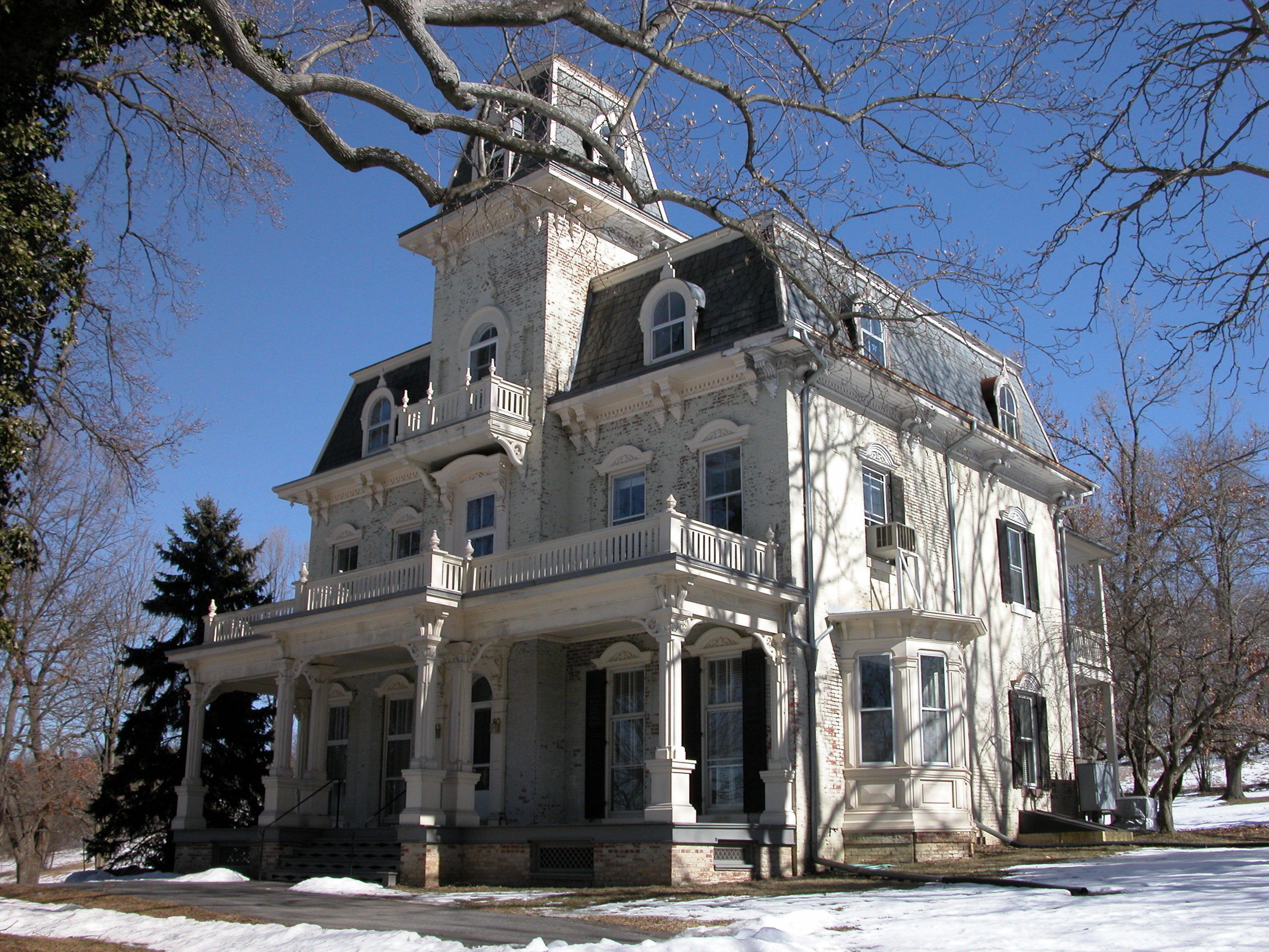
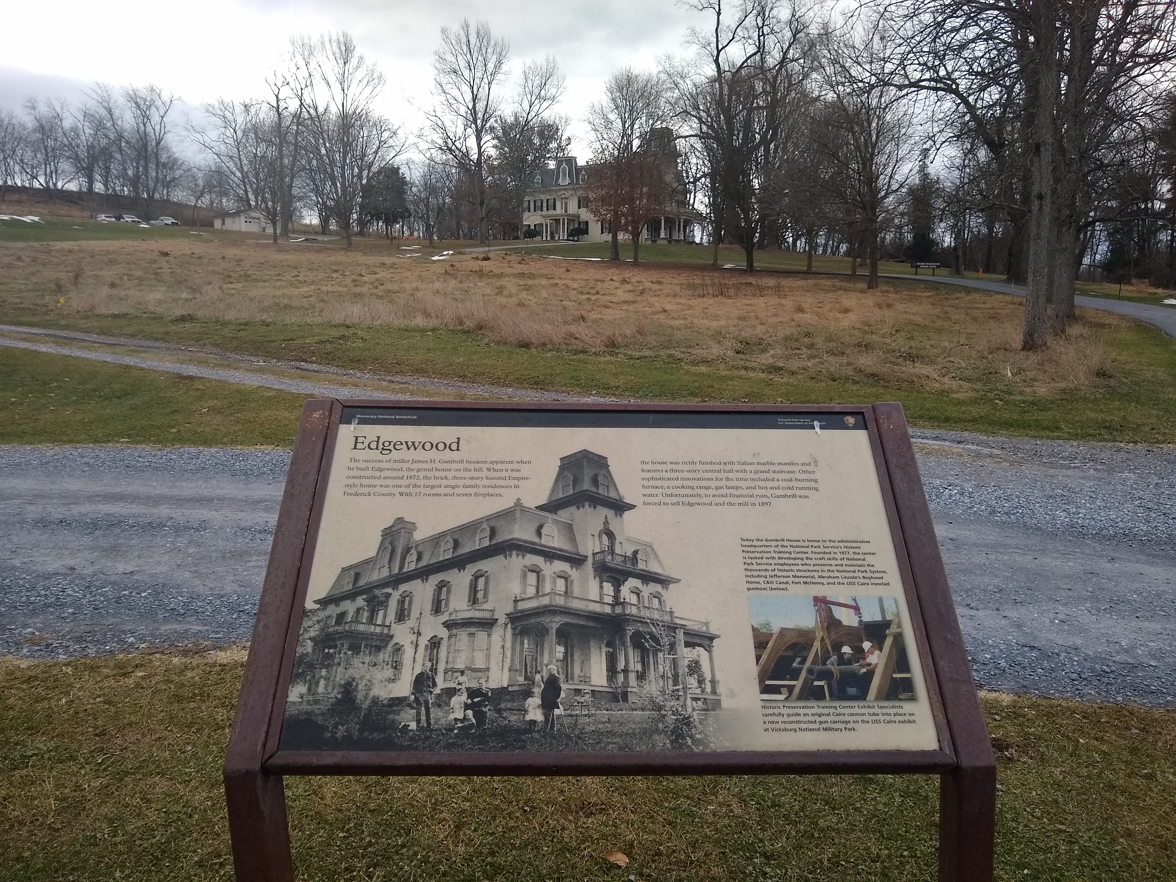
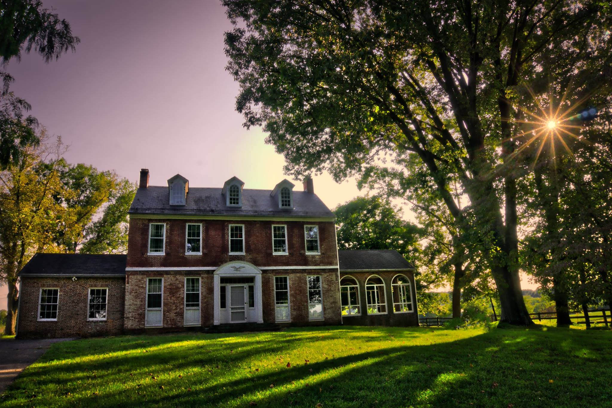
Built by the Gambrill family 1872-1873. The family owned the Gambrill Mill and lived in the miller’s house during the Battle of Monocacy. Today it houses the headquarters of the NPS Historic Preservation Training Center.
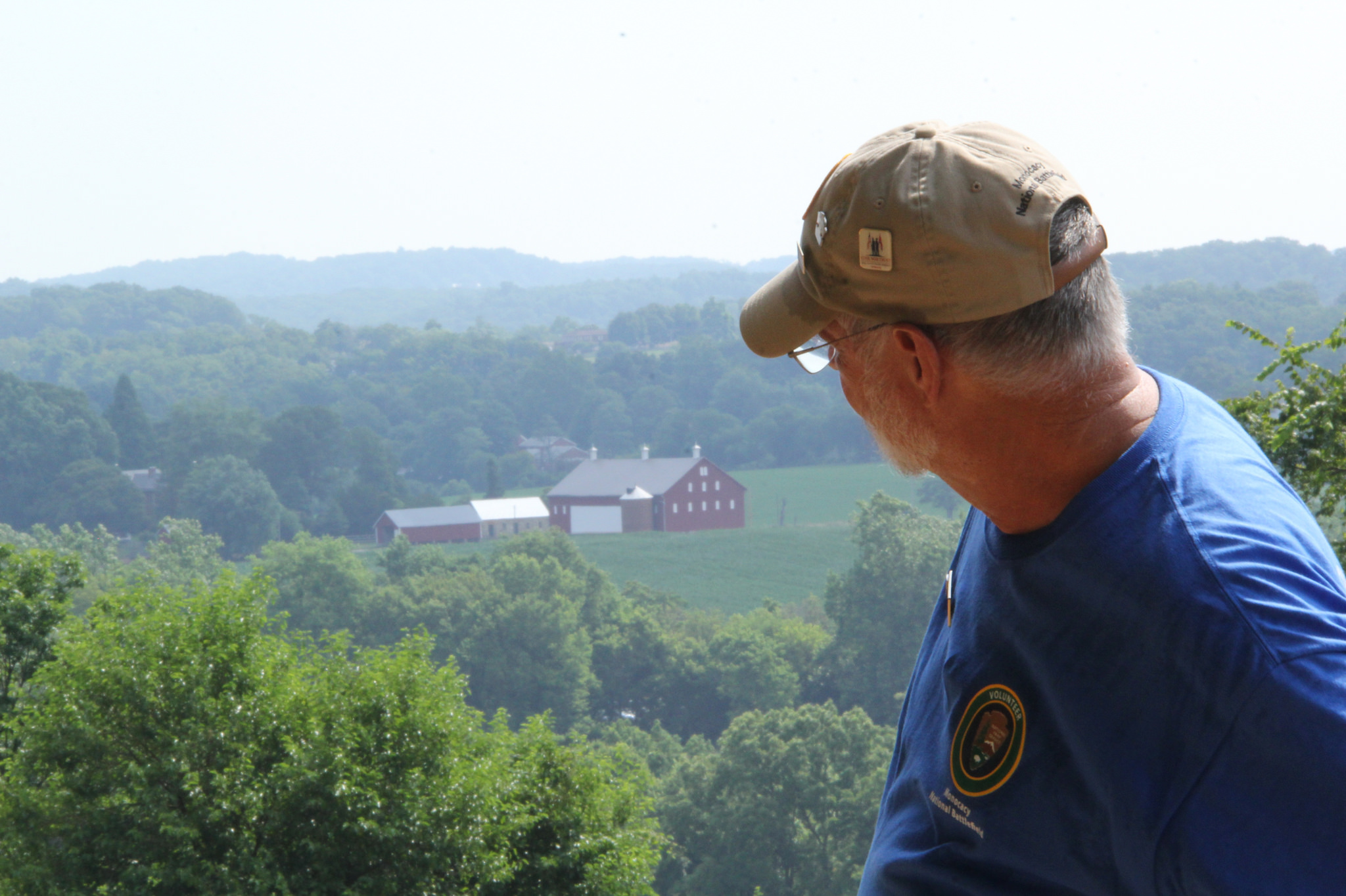
This description is 450 words in length. The Gambrill house rests on the hill above the parking area at the Gambrill Mill, four miles south of Frederick on Route 355. A paved service lane leads up the hill to the house. There is an additional parking area for the Historic Preservation Training Center up the hill near the house. There are brick walkways from the parking area to the side entry way and to the back door to the house. Walking around the house will be on grass. The Gambril house is 46 feet long and 78 feet deep, okra-colored three-story home, with an 11 by 12-foot cupola on top of a tower in the center of the front or Northwest-side of the house. The main entry is an elaborate double-door located on the Northwest façade. Above the doorway is a round-arched transom light with patterned frosted glass. A porch extents the length of the front of the house. Above the main entry is a second-floor balcony. The roof of the mansard roof is covered with slate shingles. The roof has round-arch dormers on all sides. At the top of each rounded arch is a fleur-de-lis finial. A tower, topped with a cupola, rises four stories from the center of the front entry. Looking to the North is the hill down toward the Gambrill Mill parking area. There are a few trees on the hill. Notably, in the foreground, are two poplar trees that were planted shortly after the home was built. The southwest-side of the house has a 10’ long bay window that extends approximately 3 feet from the house. A 50-foot wide lawn lays between the house and a wood line. Beyond the tree-line is a narrow-wooded area and slope down to Route 355. South of the house is open yard with a few trees that extends approximately 90 feet slightly uphill toward a partially wooded and scrub covered hill. The northeast side of the house has a bay window that mirrors the one on the southwest side of the house. Beyond that is the 16 by 8-foot carriage entry (porch). The doorway is flanked by paneled pilasters with large brackets supporting the entablature, which is lined with dentil-like brackets. The door has four raised panels with moldings. The roof of this entryway is sheet metal. Further east of the porch is a paved loop driveway with trees on the periphery and four parking spaced on the south side. To the south of the parking is a one-story okra-colored cement black office that looks like a two-car garage. To the east of that building is a parking area that can accommodate approximately 20 vehicles.
During the Civil War, James H. Gambrill owned and operated a flour mill, a sawmill, and a plaster mill on this land. Today only the first two-levels of the flour mill remain. A wheelchair accessible boardwalk provides access to a scenic overlook of the Monocacy River and the road and railroad bridges.
This description is 250 words long. Gambrill Mill is a 115-acre tract of land. It is bounded by the Monocacy River to the north, Bush Creek to the east, private property to south, and Urbana Pike (Route 355) to the west. The property is divided between floodplain next to the river, a sloped area, and a flat hilltop field. Entrance to the property is via a paved drive from Urbana Pike that leads to a public parking area next to the old stone mill building. The mill building is a square stone building that is two stories tall. There is a small pond and a picnic area near the mill building. From the parking area the road continues south, up a hill to the Gambrill House and the National Park Service maintenance area. In the northeast corner of the parking lot is the start of a wheelchair accessible boardwalk. The boardwalk has low curbs on the edges, but only has railings on bridges and the viewing platform. The boardwalk leads from the parking area to a scenic overlook. From the overlook the railroad bridge is visible to the east and the road bridge to the west. The boardwalk ends at the viewing platform and a ramp leads down to a grassy, mowed trail. The mowed trail is mostly flat, but ground hogs live here and occasionally create holes. The trail continues southeast along Bush Creek until it meets a historic road trace and turns west and loops back towards the mill building and the parking area.
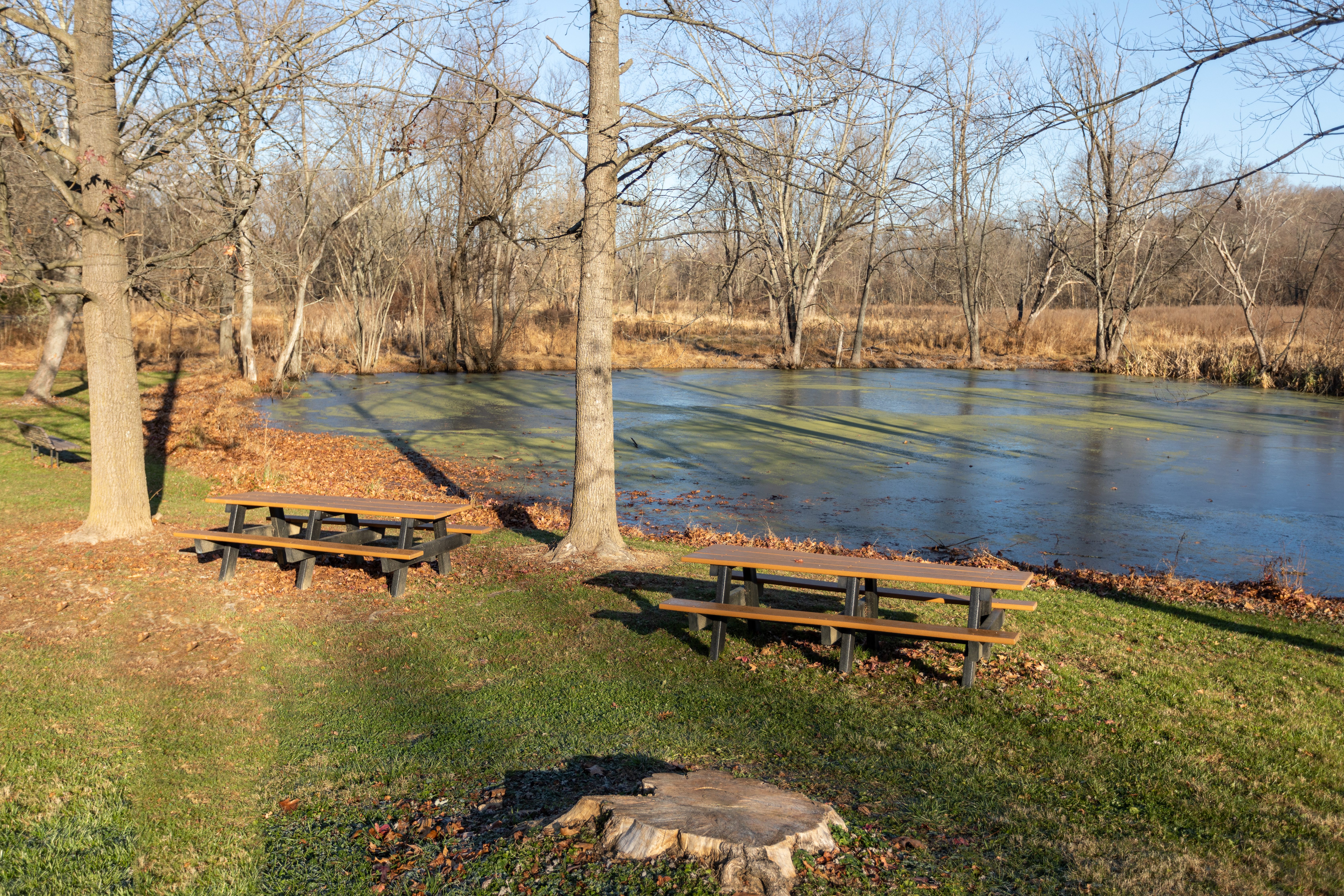
Located near the historic Gambrill Mill, the picnic area has picnic tables, a pond, and a meadow. Access to Bush Creek and the Monocacy River is a short walk away.
The Gambrill Mill Picnic Area is a level, grassy area with several picnic tables and a bench. The picnic area is located between the historic Gambrill Mill building and a small pond. For an in depth description of the mill building visit the Gambrill Mill place page. The pond is a small (0.35 acres) pond. It is ringed with trees. In spring, summer, and fall the surface of the pond is covered in green plant growth. Turtles, frogs, and fish may be observed in the pond. A small stream on the north side of the pond runs through woods and connects to the Monocacy River. The pond is bordered on the south, east, and north sides by a grassy meadow. The meadow provides habitat for ground nesting birds and a variety of other animals. To the northwest of the pond and the picnic area is a wooded area that continues a quarter-mile to the river. A boardwalk that begins in the northeast corner of the parking lot leads through the woods to the river.
The pump house contains equipment that has served as part of an elaborate system to provide hot and cold running water for indoor plumbing to the Gambrill House on top of the hill.
The Pump House is located approximately 25 feet to the right of the Gambrill Mill Trail boardwalk. Today it contains the remnants for equipment that was used to pump water to the Gambrill House on the hill. It is also part of the Gambrill Mill Picnic Area sits just south of the parking area, four miles south of Frederick on Route 355. Parking is available with two handicap accessible spaces. The pump house is a 10 by 8 foot wood structure with a metal roof. The building is quite dilapidated with much of the wood siding gone. The door is missing on the front so one has a view directly into the building and out the back of the building where additional wood siding is missing. To the left of the open door, just below the roof a piece of rusty equipment is sticking out of the building. Below, more than half of the wood siding is missing, and you can see that is attached to a long rusty pole that rests on the floor. You cannot see if there is a floor to the building as there is a layer of debris, both from the building materials, and surrounding woods. There were no windows to the structure as it was a utilitarian building specifically housing the hydraulic pump. The interior of the structure is full of debris and old machinery. The structure itself is located on a wood line that parallels the boardwalk trail and remnants of the mill race behind the structure. Beyond the wood line and stream is a meadow of native grasses that provide habitat for ground nesting birds and a variety of other animals. Also, beyond the structure to the left is the Gambrill pond. There is a bench and depending on the time of year there will be one or two picnic tables. To your left is a wooded area that continues to the river, approximately one-quarter of a mile north. The mill trail that began on the northwest corner of the parking lot to the right of the structure, continues for one-half mile in a circular route taking you toward the river, then follows Bush Creek to the historic wagon road that leads back to the Gambrill Mill and parking area. To your right is the parking area for the Gambrill farm and stone path that leads to the Gambrill Mill. There is an interpretive sign in the parking area and a picnic table in the grassy area between the parking area, mill, and service road.
Two waysides near the Worthington House highlight the important events that occurred at the farm on July 9, 1864. The "Ambush" wayside details the first Confederate attack after they succeeded in crossing the Monocacy River at the nearby ford. The "Through the Eyes of Child" wayside addresses Glenn Worthington's experience as he watched the battle from a basement window.
The “Ambush” and “Through a Child’s Eyes” waysides are located in a small graveled area to the east of the front side of the Worthington House. The Ambush wayside faces East, towards the Thomas House. The Through the Eyes of a Child wayside faces West towards the Worthington House. Beyond the panel is a view of the Worthington House and the rolling hills of the Worthington Farm looking toward Braddock Mountain. On the top third of the Ambush wayside is description of the day’s battle action. The bottom two thirds show a map of the battlefield with troop movements on the Worthington Farm displayed on it along with one quote. There are small circular pictures of both Union Brigadier General James B. Ricketts and Confederate Brigadier General John McCausland superimposed on the map. There is a small inset picture of the farm as it appeared closer to the time of the battle. There is also a map legend which includes symbols for Union and Confederate troops as well as Union Artillery. Ambush On the morning of July 9, 1864, John T. Worthington sent his family to safety in the cellar. From an upstairs window he watched Confederate General McCausland lead is cavalry brigade of 1,400 men into an ambush. Concealed behind a fence and waist high corn, 1,400 Union troops awaited the dismounted cavalrymen. As the cavalrymen drew closer, the Union line opened fire. They decimated the Confederates, who quickly fell back. Later in the afternoon McCausland launched a second attack and took the Thomas House. The outflanked Union line fell back to the Georgetown Pike, launched a counter attack, and drove the Confederate once more back to the Worthington Farm The quote reads as follows: “We remained under the terrific fire about one hour, in which time we lost one-third of the command killed and wounded”. Corporal Alexandria St. Clair, 16th Virginia Calvary The bottom two thirds of the wayside panel map of the Worthington Farm that shows troops movements during the battle that happened on the farm. To the left of the map is a legend that shows blue Union and gray Confederate troop symbols along with blue Union artillery symbols. The right top side of the map has inset pictures of both Union Brigadier General James B. Ricketts and Confederate General John McCausland superimposed on the map. The small circular inset picture of Brigadier General James B. Ricketts has the following description: “Brigadier General James B. Ricketts commanded the Union defense at the Thomas Farm. The small circular inset picture of Brigadier General John McCausland has the following description: “Brigadier General John McCausland commanded the Confederate dismounted cavalry attacks. On the right of the map is a rectangular picture of the farm and it’s buildings as it appeared closer to the time of the battle
This Gambrill House wayside provides information about the history of the house that is in the view on the incline above the wayside beyond a line of trees. It also describes the current use of the house as the headquarters for the Historic Preservation Training Center.
This description is 760 words long. Gambrill House wayside is located four miles south of Frederick, MD off Rt. 355 on the Gambrill Farm on the grass ten feet inside the left fork on the service road to the right of the Gambrill Mill. There is a parking lot at the bottom of the hill before the service road goes past the mill and up the hill to the fork. There is no accommodation for accessibility in this area. The wayside is a typical National Park Service wayside roughly 3 feet tall and is rectangular in shape with a brown metal frame supporting a laminated informative panel that is roughly 2 feet by 3 feet. The panel has an image of the Gambrill House, circa 1870s with an inset text and an image about the Historic Preservation Training Center. The main, large image on the wayside is a historic photograph circa mid-late 1870’s of members of the Gambrill family standing on the southeast corner of their home on the hill. Antoinette Gambrill is seated and holding the hand of one of the small children, with a small boy sitting in front of them. To their right (viewer’s left) stands one of the older boys with a dog lying in the grass at his feet. An African American woman stands behind them close to the house. To the right of them is James Gambrill standing with another small child and possibly another of the older children behind them. An African American man stands behind the trio closer to the house. Text on either side of the house at top of wayside read: “The success of miller James H. Gambrill became apparent when he built Edgewood, the grand house on the hill. When it was constructed around 1872, the brick, three-story Second Empire-style house was one of the largest single-family residences in Frederick County. With 17 rooms and seven fireplaces. The house was richly finished with Italian marble mantles and features a three-story central hall with a grand staircase. Other sophisticated innovations for the time included a coal-burning furnace, a cooking range, gas lamps, and hot and cold running water. Unfortunately, to avoid financial ruin, Gambrill was forced to sell Edgewood and the mill in 1897.” On the right of the wayside is information about the current use of the house as the headquarters for the Historic Preservation Training Center with an image of two men in white hard hats installing a cannon tube onto the carriage with the use of a straps and bracing to both hold and lower the cannon tube. Text above the image: “Today the Gambrill House is home to the administrative headquarters of the National Park Service’s Historic Preservation Training Center. Founded in 1977, the center is tasked with developing the craft skills of National Park Service employees who preserve and maintain the thousands of historic structures in the National Park System, including Jefferson Memorial, Abraham Lincoln’s Boyhood Home, C&O Canal, Fort McHenry, and the USS Cairo ironclad gunboat (below).” Below the image: “Historic Preservation Training Center Exhibit Specialists carefully guide an original Cairo cannon tube into place on a new reconstructed gun carriage on the USS Cairo exhibit at Vicksburg National Military Park.” The view surrounding the wayside: The foreground as you look southwest is a scrub field with a line of trees in the back of the field that border the service road to the Gambrill House. Beyond the road you can see the East side of the house and garage/office building to the left of the house. To your left is a grassy area that borders the service road that continues to the park maintenance facility a gray utilitarian type building with a two-bay garage. To the left of the building is a line of trees that denote the remnants of the mill race that fed the Gambrill Mill. Behind you is a grassy area that leads to a fence 100 feet away. The fence denotes an area of grassland that is full of native grasses, much of it providing material for ground nesting birds and other animals. In the middle of this 14-acre field is a 800-feet long roadbed that was used by farmers in the 19th century to get their crops to the train. To your right you are looking downhill to the Gambrill Mill, what looks like a two-story stone house from this perspective 175 feet away. To the left is the service road and then another large field as part of the hill. To the right of the Mill is a lightly wooded area with a pond and two picnic tables.
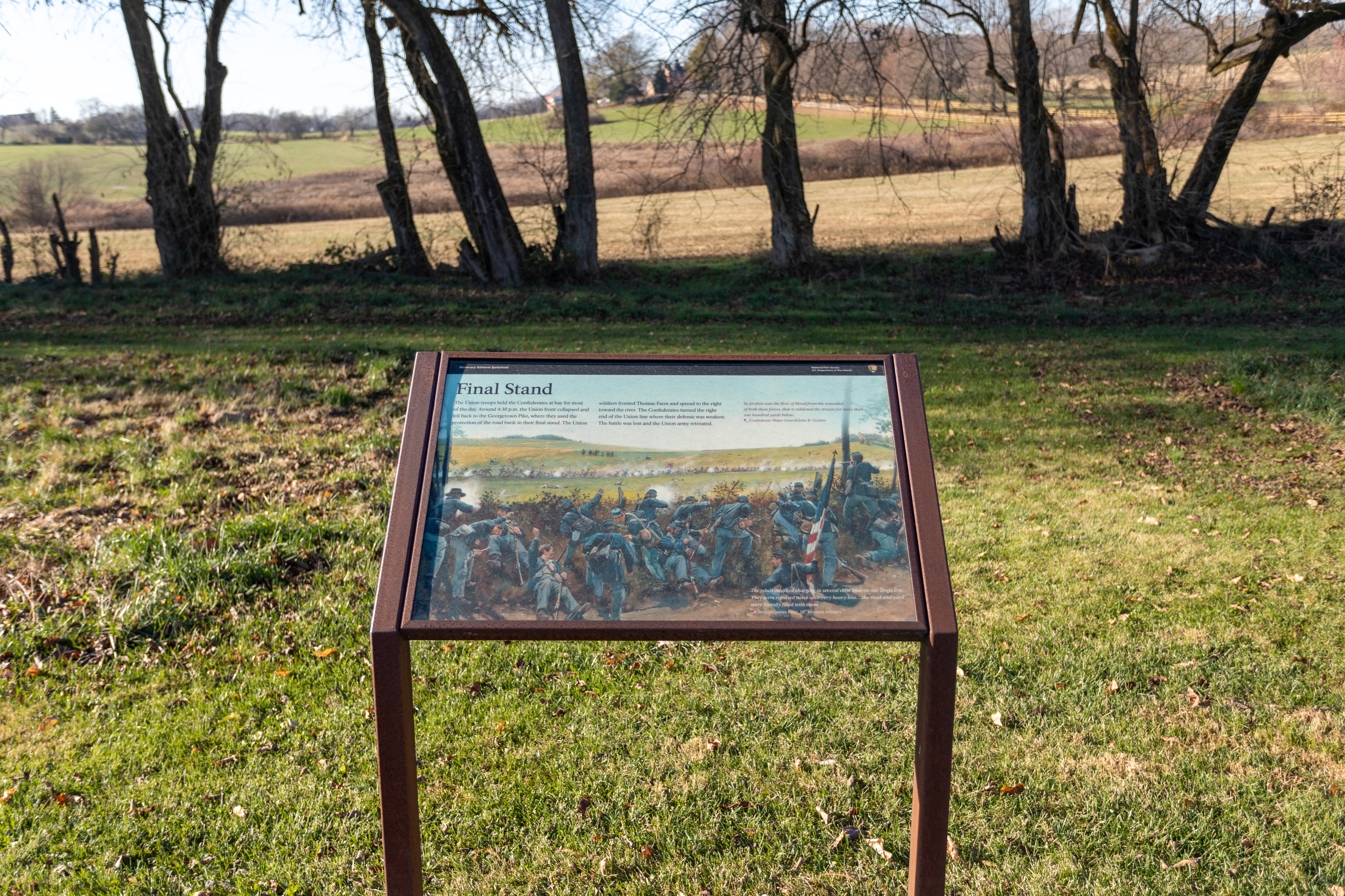
This wayside addresses the actions of Union troops during the Battle of Monocacy on the east end of the Thomas Farm just off the Georgetown Pike and north of Baker Valley Road.
This description is 360 words long. The Final Stand Wayside is an informative laminated panel typical of most National Park Service waysides. The wayside is a typical National Park Service wayside roughly 3 feet tall and is rectangular in shape with a brown metal frame supporting a laminated informative panel that is roughly 2 feet by 3 feet. It is located on the southbound side of Araby Church Road roughly 200 yards north of the intersection with Baker Valley Road. There is a pull off and parking area that will accommodate multiple vehicles in front of the wayside. Behind the panel is the Thomas Farm with its fields, buildings and sweeping views of what remains today of the farm. The Thomas Farm remains an active farm with both crops and livestock. The wayside has an artist’s rendering in color. It shows Union troops in the foreground using the road bank of the Georgetown Pike for protection while engaging Confederate troops approaching from the Thomas Farm in the west. Beyond the Confederate troops in the picture, the buildings of the Thomas Farm are visible. The picture shows the smoke of gunfire and Union troops in various stages of loading and firing their rifles. Final Stand The Union Troops held the Confederates at bay for most of the day. Around 4:30 p.m. the Union front collapsed and fell back to the Georgetown Pike, where they used the protection of the road bank in their final stand. The Union soldiers fronted the Thomas Farm and spread to the right toward the river. The Confederates turned the right end of the Union line where their defense was weakest. The battle was lost and the Union army retreated. There are two quotes on the wayside panel: The first quote reads: “So profuse was the flow of blood from the wounded of both these forces, that it reddened the stream for more than one hundred yards below”, Confederate Major General John B. Gordon The second quote reads: “The rebels attacked charging in several close lines on our single line. They were repulsed twice with very heavy loss…the road and yard were literally filled with them.”, Sergeant James Reed, 10th Vermont Infantry.
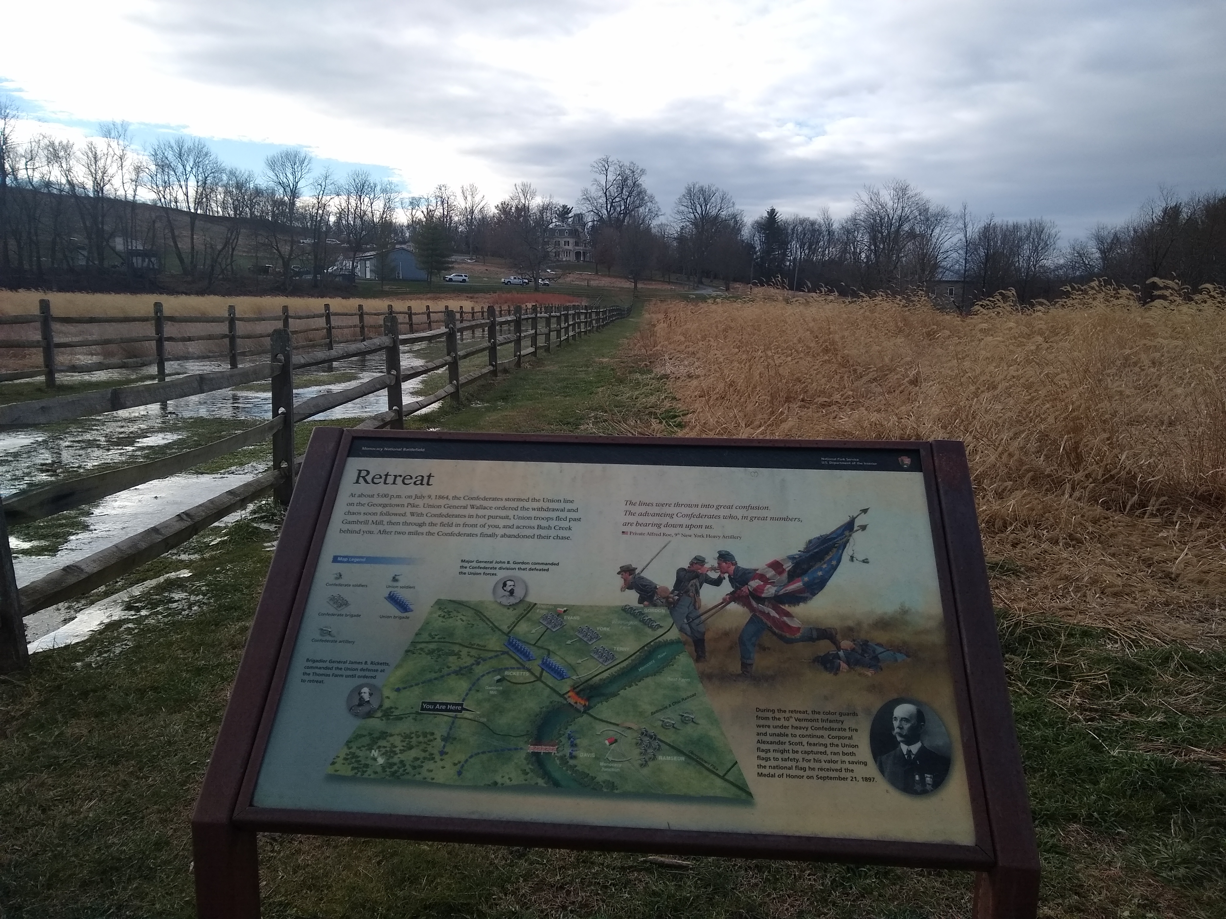
This wayside addresses the retreat of Union troops at the end of the Battle of Monocacy on the Gambrill Mill Property just south of Bush Creek. The wayside is located off of a flat, mowed grass trail.
The Retreat wayside is located on the Grambrill Mill Trail roughly four tenths of a mile from the parking lot trailhead by the Gambrill Mill. The wayside is located on the trail facing south along Bush Creek where the trail makes a right turn to head south into a meadow between two fence lines. The wayside is a typical National Park Service wayside roughly 3 feet tall and is rectangular in shape with a brown metal frame supporting a laminated informative panel that is roughly 2 feet by 3 feet. The panel has a color artist’s rendering of Union troops in retreat with one solider carrying two US Flags in retreat, one solider firing his weapon, another running to in retreat and lastly one wounder solider laying on the ground. There is a battle map showing where both Union and Confederate forces were on the battlefield just before the retreat was ordered. The main body of text on the upper third of the wayside reads as follows: Retreat At about 5:00 p.m. on July 6, 1864, the Confederates stormed the Union line on the Georgetown Pike. Union General Wallace ordered the withdrawal and chaos soon followed. With Confederates in hot pursuit, Union troops fled past Gambrill Mill, then through the field in front of you, and across Bush Creek behind you. After two miles the Confederates finally abandoned their chase. There is one quote on the wayside panel: The quote reads: “The lines were thrown into great confusion. The advancing Confederates who, in great numbers, are bearing down upon us.” Private Alfred Roe, 9th New York Heavy Artillery There is a photographic inset in the lower right corner with an oval picture of Corporal Alexander Scott post war in a suite with a tie and vest on wearing his Civil War medals with the following description: During the retreat, the color guards form the 10th Vermont Infantry were under heavy Confederate fire and unable to continue. Corporal Alexander Scott, fearing the Union flags might be captured, ran both flags to safety. For his valor in saving the national flat he received the Medal of Honor on September 21, 1897 There are two notes along with black and white circular pictures on the maps about key command officers in the battle and a map key that describes symbols used to portray Union and Confederate units on the battlefield. The first note reads: Brigadier General James B. Ricketts, commanded the Union defense at the Thomas Farm until ordered to retreat The second note reads: Major General John B, Gordon commanded the Confederate division that defeated the Union Forces.
Two waysides near the Worthington House highlight the important events that occurred at the farm on July 9, 1864.
This description is 450 words long. The “Ambush” and “Through a Child’s Eyes” waysides are located in a small graveled area to the east of the front side of the Worthington House. The Ambush wayside faces East, towards the Thomas House. The Through the Eyes of a Child wayside faces West towards the Worthington House. Beyond the panel is a view of the Worthington House and the rolling hills of the Worthington Farm looking toward Braddock Mountain. The Through the Eyes of Child wayside background is an artist’s color rendering of 6-year-old Glenn Worthington watching the battle from a boarded window in his basement. The top third of the panel has text describing his experience and the bottom third has two rectangular pictures one of Glenn Worthington as child with his cousin and a second of Worthington later in life The main body of text in the upper third of the wayside reads as follows: Through a Child’s Eyes On the morning of July 9, 1864, six-year-old Glenn Worthington was ushered into the farmhouse cellar with his family and their slaves. The window had been boarded with thick oak boards and tubs of drinking water were placed in the cellar. Young Glenn peered between the gaps of the boarded windows, witnessing horrific events as the battle unfolded. When the fighting stopped, Glenn helped his family tend to the wounded soldiers who lay in the yard. That afternoon, Glenn was injured while trying to retrieve a bayonet from a pile of burning rifles. A coal from the fire ignited a cartridge, which exploded in his face. Glenn was burned, but fully recovered within a few weeks. The bottom left-hand corner of the wayside two rectangular pictures. From left to right the pictures and descriptions are as follows: A rectangular picture of a very young Glenn Worthington in what appears to be a sailor’s uniform with a young girl in a with dress. The picture’s caption reads: “Glenn Worthington and his cousin about 1860”. The second picture is a picture of Glenn Worthington at an unknown date but clearly a young man. The description reads as follows: “Glenn H. Worthington (1858-1934) graduated from the University of Maryland School of Law in 1887. He was a farmer, teacher, and judge. In 1932 Glenn published the first complete account of the battle of Monocacy. His retelling of historical events helped persuade Congress to establish Monocacy National Battlefield in 1934.
Scenic view of Monocacy River with interpretive waysides describing the burning of the covered bridge during the Battle of Monocacy and the Union retreat over the railroad bridge.
The Burning the Bridge wayside is located on the Gambrill Mill Trail on the boardwalk facing North-West overlooking the Monocacy River. The wayside is posted along the boardwalk fencing. The wayside is a typical National Park Service wayside roughly 3 feet tall and is rectangular in shape with a brown metal frame supporting a laminated informative panel that is roughly 2 feet by 3 feet. The panel has an artist’s color rendering of Union troops retreating across the Georgetown Pike wooden covered bridge. The bridge is on fire with thick smoke billowing from the roof. Two Union soldiers carrying their weapons and packs are retreating toward the viewer while one Union solder lies wounded on the ground. Two other Union soldiers are trapped on the other side of the Monocacy River. The view surrounding the wayside: The foreground as you look North-West is a slope down to the Monocacy River with tree cover to the left when facing the wayside. Above the river stretches the present-day Urbana Pike, Route 355, roughly were the old Georgetown Pike wooden covered bridge stood. To your left is the boardwalk trail stretching back to the Gambrill Mill parking lot. Behind you is a wet meadow wetland full of swampy brush and scrub. The trail circles the wetland. To your right is another wayside the Desperate Escape wayside as well as a ramp leading down from the boardwalk onto the ground level trail.
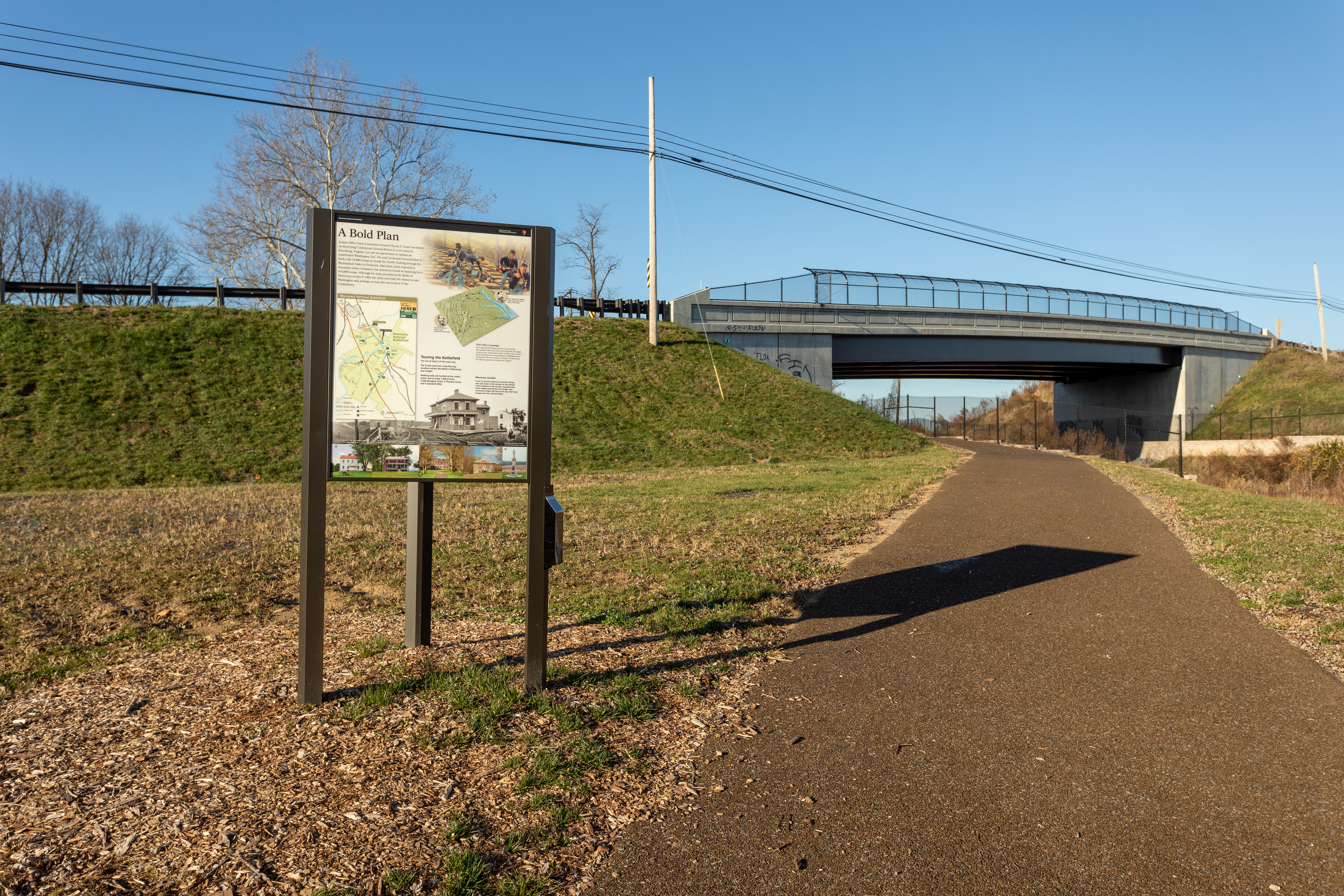
The “A Bold Plan” wayside is at the end of the publicly accessible portion of Worthington Lane next to the parking area. It addresses General R E Lee’s plans to disrupt Union plans and has a high-level review of the driving tour and it’s stops.
This description is 860 words long. The “A Bold Plan” wayside is at the end of the publicly accessible portion of Worthington drive next to the parking area. It addresses General R E Lee’s plans to disrupt Union plans and has a high-level review of the driving tour and it’s stops. Behind the panel is the Worthington Farm with its fields, buildings and rolling hills with views of Braddock Mountain in the distance. The Worthington Farm remains an active farm with both crops and livestock. On the upper left-hand corner of the panel there is a brief overview of Lee’s strategy in ordering General Jubal Early to begin the 1864 Valley Campaign. The panel in the upper right-hand corner is a color artist’s rendering of Confederate cavalry. The bottom two thirds of the panel is made up of pictures of all five stops of the Monocacy NB driving tour. There are three maps: one of the battlefield layout, a map of the driving tour and another that shows the route of Early’s 1864 Valley Campaign. The wayside is laid out and reads as follows: A Bold Plan In June 1864, with Union Lieutenant General Ulysses S Grant intent on destroying Confederate General Robert E. Lee’s army, Lee developed a bold pan to capture Washington, D.C. He sent Lieutenant General Jubal A. Early with 15,000 troops to invade the North. Pushing through the Shenandoah Valley to Frederick, Maryland, Early expected to encounter minor resistance, but instead he found an opposing force of 6,600 troops he had not anticipated. Although his army prevailed at the Battle of Monocacy on July 9th, 1864, the delay cost his army the chance to take Washington and, perhaps, to turn the tide of the war in favor of the confederates. There is one quote on the wayside panel: The quote reads: “I therefore decided…to turn down the …to threaten Washington and if I find an opportunity---to take it”, Confederate General Jubal A. Early On the upper right is an artist’s rendering of Union and Confederate forces engaged in battle at the Thomas Farm with the Union in the foreground and Confederate forces in the background of the picture. Just below the picture of battle on the right side of the panel is a map of the 1864 Valley Campaign which shows Early’s movements starting in Richmond, Virginia and moving through the Shenandoah Valley and into Maryland, and then back into Virginia. The map also shows the movement of Union troops ordered by Grant to reinforce Washington DC. The Map has this description: 1864 Valley Campaign Early departed Richmond on June 13, secured the Shenandoah Valley, and moved into Maryland. He fought Union troops, reinforced by Grant, at Monocacy on July 9. Early then advanced on the defenses of Washington and reached Fort Stevens on July 11. On July 12 Early found the odds too great and retreated into Virginia. To the left of the Valley Campaign map is a small oval inset picture of Lieutenant General Jubal A. Early, Confederate Commander. To the right is a small oval inset picture of Major General Lew Wallace, Union Commander at the battle of Monocacy. The middle third of the Wayside has a copy of the Battlefield Map with the Monocacy driving tour laid out on it with all 5 driving tour stops and other points of interest on the battlefield displayed on it. Just to the right of the Battlefield Map is this information: Touring the Battlefield You are at Stop 3 of the auto tour. The 6-mile auto tour visits five key locations where the Battle of Monocacy was fought. Walking trails are located at the visitor center and at stops 3(Worthington Farm), 4 (Thomas Farm), and 5 (Gambrill Mill). The bottom third of the wayside has pictures of all 5 driving tour stops in a horizontal order from 1 through 5 with brief descriptions that are as follows: A picture of the main house on the Best Farm with the description directly above it saying, “Tranquil today, Best Farm was caught in artillery crossfire at the battle’s beginning." A picture of the 14th New Jersey Monument with the description directly above it saying, “Defending Monocacy Junction was key to the Union’s strategy.” A picture of the main house on the Worthington Farm with the description directly above it saying, “At Worthington Farm Confederates found a way to ford the Monocacy River, shifting the battle to a new front." A picture of the main house at the Thomas Farm with the description directly above it saying, “Civilians hid in the Thomas House as the armies faced off in furious fighting here.” A picture of the Gambrill Mill with the description directly above it saying, “Gambrill Mill became a field hospital for Union soldiers.” The background of the bottom third of the wayside panel is a picture of the Worthington Farm as it stands today with description, "John T. Worthington purchased this farm in 1862. From his fields on July 9, 1864, the Confederates launched a series of attacks toward the Union line on the Thomas farm."
There are three panels at the Best Farm. One addresses the history of L’Hermitage the original plantation located on the farm. A second wayside speaks to what the Best Family went through during the Battle of Monocacy. A third wayside is a map of the buildings, both existing and now gone, that are or were part of the Best Farm.
This description is 832 words long. There are three waysides at the Best Farm each is an informative laminated panel. The waysides are adjacent a parking area. Behind the waysides are the buildings of the Best Farm. From Left to right the waysides are: L’Hermitage, Caught in the Crossfire, and Best Farm. The L’Hermitage wayside faces east. Beyond the wayside is a rectangular building with white walls and a red metal roof with two chimneys. The wayside has a color picture of the farm. In the picture is a secondary building on the farm built in the 1790s. Beyond the secondary building are superimposed renditions of what enslaved worker’s quarters would have looked like that were on the farm. The locations of these quarters are based on an archeological study completed on the farm. L’Hermitage Panel In the late 1700s, a large slave village was constructed just beyond the building in front of you. By 1800, as many as 90 enslaved laborers were housed there, an usually large number of slaves for this area. The enslaved people were the property of the Vincendiere family, French planters who fled a slave revolt in Saint-Domingue (now Haiti) in 1793. They acquired land and enslaved laborers to establish L’Hermitage plantation, seemingly intent on recreating the Caribbean slave system there in Frederick County. Local authorities, however, did not favor their approach; court records indicate that members of the household were accused of mistreating their slaves and withholding food and clothing. L’Hermitage was sold in 1827, and there was never again a sizable enslaved population at the farm. A quote on the panel reads: “One can see a row of wood house and one stone house…(and) instruments of torture, stocks, wooden horses, whips, etc..They foam with rage, beat the negroes, complain and fight with each other”, Julian Ursyn Niemcewicz’s 1798 eye-witness account of L’Hermitage On the bottom third are three pictures of items found during the archeology study at the Best Farm from left to right a brooch, two coins and a shell pendant. The caption: “In 2003, archeologists confirmed the location of the L’Hermitage slave village. Building foundations and artifacts unearthed at the site shed light on a dark past and help tell the stories of the people who toiled here.” Caught in the Crossfire Panel The panel has a black and white photograph of soldiers posing in camp as it’s background. There are two small oval pictures of John and Margaret Best with a brief description of what they did during the battle. There are also pictures of broken pieces of dishes found during an archeological study completed on the farm. The wayside reads: Since the war’s onset John T. Best had grown accustomed to seeing Union and Confederate soldiers on his farm but the morning of July 9, 1864 was different. Shots rang out on the farm and a battle ensued. Confederate artillery moved into the field, exchanging fire with Union artillery on the heights. Union infantrymen were easy targets for Confederate sharpshooters hidden in the Best’s barn until a Union artillerist spied puffs of smoke from the sharpshooters’ rifles. Union artillery pounded the barn, setting it on fire and destroying it along with tools, harvested crops, and hay. A quote reads: “The second shot burst inside the barn, and so did the third, and the fourth, the barn was soon on fire..” Private Frederick Wild, Alexander’s Baltimore Battery The lower left corner is a description of the photo: “Best Farm was a crossroads of war. Armies from both sides frequently camped here throughout the Civil War, like these soldiers posing for camp side photo. On the upper right side are oval pictures of John and Margaret Best with a description reading: “John and Margaret Best hid in the house with their children during the battle. The Best filed claims against the Federal government after the war for property that Union soldiers stole or destroyed in 1862. No claims are known for the 1864 destruction. On the lower right is a picture of three broken ceramic dishes of various size and shape with the caption: These fragments of dishes broken during the 1864 battle, were found buried near the farmhouse. Best Farm Panel The panel is divided in three sections a map of the Best Farm, rules of the park, and a picture of the Stone Barn. The map on the upper third shows the farm’s buildings and approximate date of construction of each. Listed are the Well House (c. 1949), Secondary Dwelling (1790s), Main House (1790–1870s), Corncrib (1870), Log Outbuilding (1870s), Stone Barn (1790s) The rules on the middle third are as follows: Park Regulations Prohibit: Accessing railroad tracks, agricultural fields and private property, Bicycles on park trails, Relic Hunting, Metal detectors, Pets off leash, Littering, Hunting or harassing wildlife, Possession of Cultural Resources (bottles, metal
The Junction Trail parallels the B&O Railroad Frederick Spur to the first Wye Junction in the United States. There are two waysides near the junction that illuminate the role of the railroad in the battle and the U.S. Colored Troops recruiting station that was located at Monocacy Junction.
This description has 850 words. Two waysides: the left is titled "SLAVE TO SOLDIER". Text reads: “On October 1, 1863, nine months after President Lincoln’s Emancipation Proclamation, Secretary of War Edwin Stanton advised Lincoln that it was a ‘military necessity in the State of Maryland...for enlisting all persons capable of bearing arms...without regard to color....’ A ‘colored troops’ recruiting station was soon established at Monocacy Junction. Local slave owners received up to $300 for the enlistment of their slaves. Lincoln allowed slaves—who had their owner’s consent or who had escaped from owners disloyal to the Union—to enlist in the army. In return the slaves were ‘forever thereafter...free.’” To the right of the text in red italics is quoted, “Once let the black man get upon his person the brass letter, U.S., let him get an eagle on his button and musket on his shoulder and bullets in his pocket, there is no power on earth that can deny that he has earned the right to citizenship.” Below the quote is “Frederick Douglass, former slave, American abolitionist, author, orator, and statesman.” A black and white photograph of a group of 15 black Union soldiers standing in a row. The soldier on the left holds a sword that is pointed down. They stand at rest with the butts of rifles resting on the ground. Hands on top of the barrels near left shoulders with left hand above right. Some have bayonets fixed. The caption reads: “Although not recruited at Monocacy Junction, these members of the Provost Guard of the 107th Colored Infantry at Fort Corcoran near Washington, D.C. fought bravely as did the five Maryland U.S. Colored Regiments inducted here.” Lower right is a document written in flowery cursive. In the upper left is “19 tenth street Balt.” In the upper right in larger script is written, “Monocacy. Frederick Co. Md.” The next line says “Slave in Co. D. 19th Regt.” and “Jan 6th 1864.” The body of the text reads “This certifies that Samuel Adams (a slave for 30 years). Age 2020 Height 5 ft 11 ¼ in—Eyes Black Complexion copper Hair Black The property of Grafton Burgee a resident of Frederick Co. Md. Has this day been received as a recruit for the service of the United States.” The bottom line is written in the lower left: “Witness Col J.P. Creager” and in the lower right: “Charles P. Goodyear, Leut. and Recruiting Officer.” The caption reads, “At Monocacy Junction, January 6, 1864, Grafton Burgee signed over his property—William “Samuel” Adams—for $300 (receipt below), enabling Adams to join the Union army and ultimately gain his freedom. Private Adams was assigned to Company D, 19th Regiment, United States Colored Troops for three years.” The wayside on the right is titled "NICK OF TIME". Below reads: “On July 9, 1864, at 2:00 a.m., the last train of Union reinforcements pulled into Monocacy Junction just hours before the battle. The addition of 3,400 veterans increased Wallace’s total to 6,600 men. While Wallace was successful in delaying the Confederate march on Washington, he failed to stop the Confederates from destroying the junction and damaging the railroad bridge. “Railroads played a major part in the Civil War. The ability to move troops and supplies rapidly over short and long distances had an immediate effect on campaigns and battles. Because of this advantage, railroads would become prime targets for both armies throughout the war.” Below the body is quoted “A large force of veterans have arrived by water, and will be sent immediately [by train]. John W. Garrett, B&O Railroad President.” A black and white photograph of a train station with a train on a raised wooden causeway that is several feet off the ground. The engine disappears off the left side of the image. To the right is a small coal car, a freight car, and three passenger cars. A square structure on stilts is visible in the lower right corner and obscures the view of the rest of the cars. Behind the train are two buildings. The far left building is obscured by a blurring white patch (probably steam from the engine). The right building is a two story white building with a peaked roof. A window is visible in the gable of the roof. There appear to be five windows with dark shutters on the second floor. The roof of a porch is visible below them. In the background behind the building a forested hill slopes up to the right side of the image. The caption reads: “Monocacy Junction (shown here in 1858) was strategic; if destroyed it would cut off Union supplies and reinforcements to the west.” In the upper right corner is black and white drawing showing two stone piers in a river and stone abutments on both sides of the river. There is no bridge deck on top of the piers. There are burned timbers on the shore of the river in the foreground. The caption reads, “This Harpers Weekly sketch of the Confederate-destroyed bridge over the Monocacy River illustrates the havoc wrought by armies upon the railroad.”
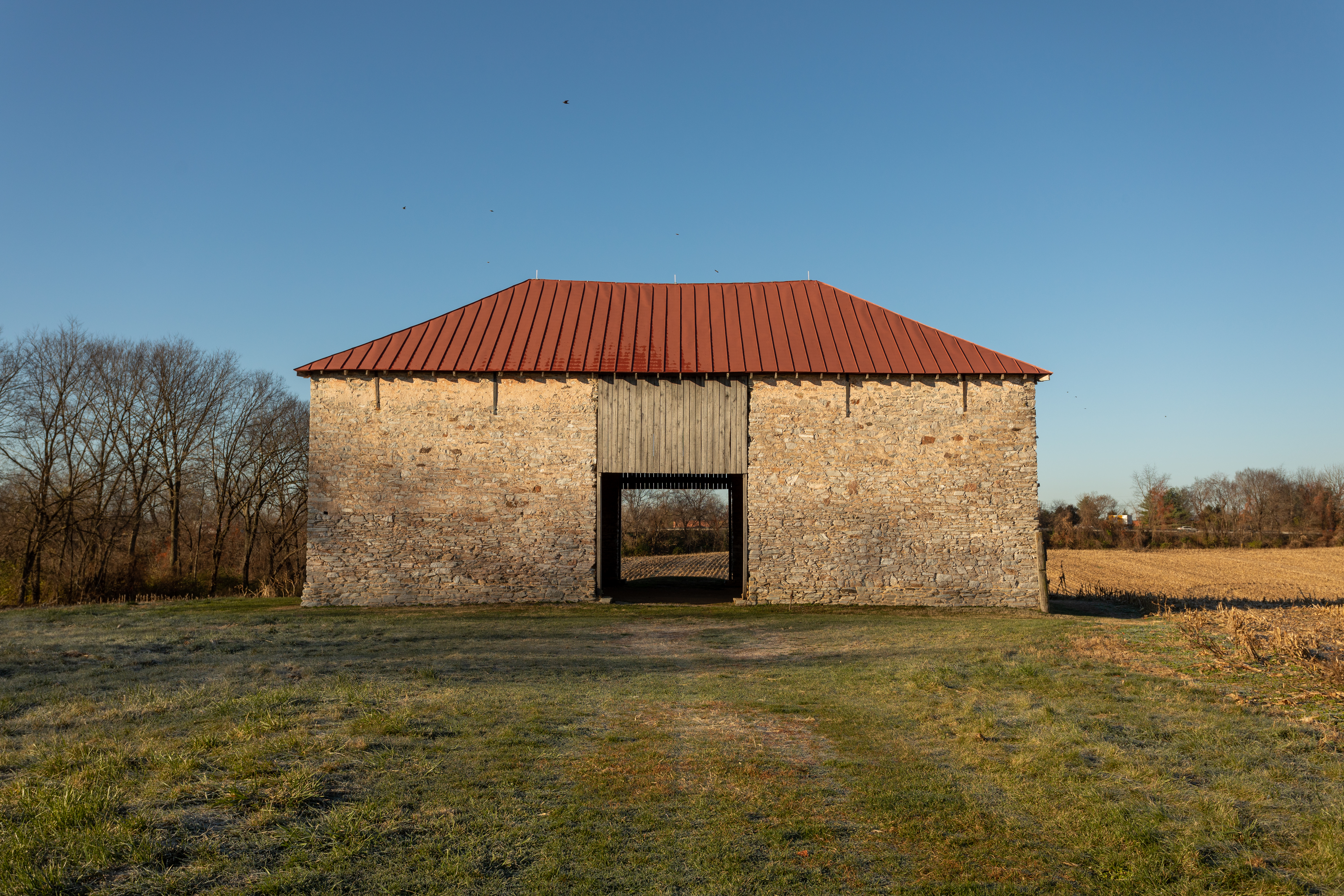
The stone barn on the Best Farm is one of the most unusual structures at Monocacy National Battlefield. It was constructed in the late 19th century by French-Caribbean immigrants.
This description has 215 words. The Best Farm or L’Hermitage stone barn is constructed of local gray colored stone and has a red metal roof. The barn’s solid stone walls are two-stories tall. On the sixty-feet long east and west sides, directly across from each other in the center of the walls are two ten-foot gaps in the stone walls that extend to the roof. The entryways are wide enough to drive a vehicle through. Vertical wooden slats block off the top of the openings. The south end of the barn is a thirty foot long solid stone wall. The north end of the barn has an opening in the center of the wall that has been partially infilled with stone to create a window. The barn is capped by a red metal, standing seam, hipped roof. Inside the barn, the floor is packed, red dirt. The stone walls are rough. Overhead the rafters and the wood slats that support the roof are visible. There is an opening with an arched top on the north end of the barn. Standing outside the barn and looking north or west are farm fields with crops. To the south and east is a mowed lawn. Two-hundred, forty feet east of the barn is a corn crib, parking area, and the main house.
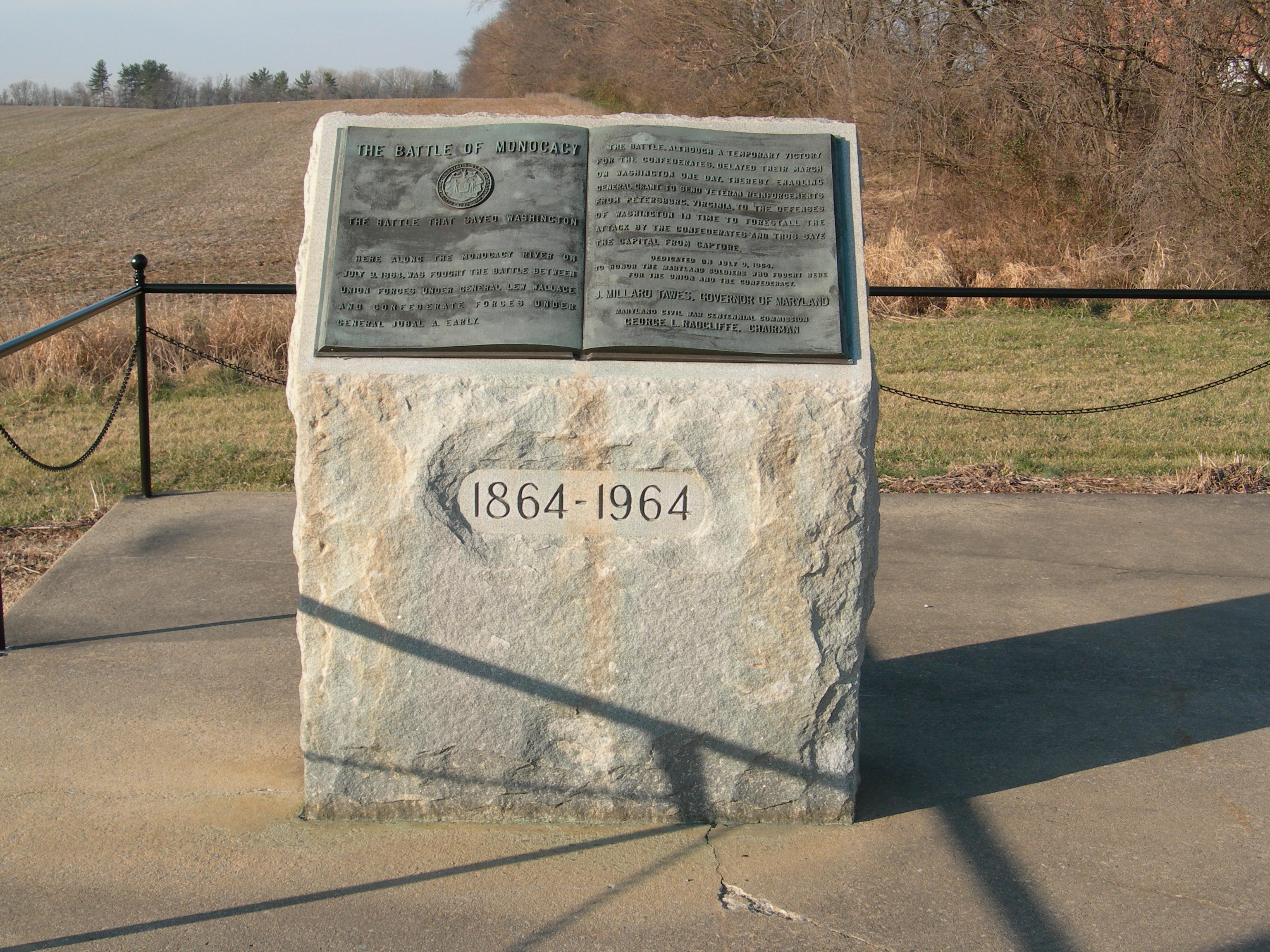
The Maryland Monument at Monocacy National Battlefield was dedicated on July 9, 1964, to commemorate the centennial of the Battle of Monocacy. The Maryland Civil War Centennial Commission dedicated the monument to the soldiers from Maryland regardless of whether they fought for the Union or the Confederacy.
This description is 580 words long. The monument is a large granite block about 4 feet high by three feet wide by two feet deep. The top is slanted forward and there is a bronze tablet in the form of an open book. Etched on the front of the monument are the years “1864 – 1964.” The sides of the monument are rough cut. On the left page of the bronze book is written in large font “The Battle of Monocacy.” Below the title is the Maryland State seal. “The Battle That Saved Washington” is on the line below the seal. The text continues: “Here along the Monocacy River on July 9, 1864, was fought the battle between Union Forces under General Lew Wallace and Confederate Forces under General Jubal A. Early.” On the right page, the text continues: “The battle, although a temporary victory for the Confederates, delayed their march on Washington one day, thereby enabling General Grant to send veteran reinforcements from Petersburg, Virginia, to the defenses of Washington in time to forestall the attack by the Confederates and thus save the Capital from capture.” In smaller font below is written, “Dedicated on July 9, 1964, to honor the Maryland soldiers who fought here for the Union and the Confederacy.” In large font below that is “J. Millard Tawes, Governor of Maryland.” In smaller font at the bottom is “Maryland Civil War Centennial Commission, George L. Radcliffe, Chairman.” The monument sits on the south end of a 40 by 20 foot concrete pad. To the north of the Maryland Monument in the center of the concrete is the United Daughters of the Confederacy Monument or UDC Monument. The UDC Monument is a rough cut eight foot tall block of granite. It is 3 feet wide and 3 feet deep. There is a bronze plaque on the front of it with writing on it. At the northwest corner of the pad is a Maryland historical marker on a pole. The edge of the concrete pad is ringed by a fence with an opening directly in front of the UDC Monument on the east side. The fence is made from black metal pipes. The fence is about three feet high with vertical supports approximately every six feet. Chains arcing between the vertical poles attaching about six inches below the top rail. Looking to the west over the top of the monument, is a field of crops. A line of trees borders the northern edge of the field. The ground slopes gently upward to the west, leaving just the tops of trees visible in the distance. Facing south, a two lane road stretches into the distance, disappearing around a curve to the left. A split rail fence with six rails separates the road from the field of crops to the west. Telephone poles with wires stretching between them line both sides of the road. In the far distance are tree covered hills. To the east, on the other side of the two-lane road is another six rail, split-rail fence that separates the road from a field of crops. Across the field, about 500 feet away is a barn shaped building with a green, metal roof. This is the park visitor center. Behind the visitor center trees line the edge of the field. To the north, the road expands into four lanes. Telephone poles with wires stretching between them line both sides of the road. Buildings are partially visible behind trees in the distance on both sides of the road.
Erected by the state of Pennsylvania and unveiled on November 24, 1908, this was the second monument to be constructed on the battlefield. The monument honors the soldiers from 67th, 87th, and 138th Pennsylvania Regiments who fought at the Battle of Monocacy for the Union forces.
This description has 535 words. The monument is constructed of blue westerly Rhode Island granite and stands 35 feet high on a 10-focrt-square base. On top of the base is an 8-foot square that is about 18 inches tall. On the west face of this level is a bronze plaque with the symbol of the State of New Jersey. The south face of this level has the “87th PA. Vol.” carved into the vertical face. The east face is inscribed “67th PA. Vol.” The north face is inscribed “138th PA. Vol.” The next level is about 6 feet across the base and tapers up to a four foot square with columns carved into the four corners of this level. The insets on all four sides of this level are a darker gray granite. All four sides have inscriptions carved into the dark gray granite. The west face is inscribed: “Erected by the Commonwealth of Penna in commemoration of the bravery, sacrifice, and patriotism of the 67th, 87th, and 138th regiments that fought on this battlefield July 9, 1864. Commissioners Wm. H Lanius, Capt. Co. I. 87th; Robert I Conrwall, Capt. Co. I 67th; M. Coppleberger, Priv. Co. A 138th.” The south face is inscribed “87th Regt. PA. Vol Inf. 1st Brig 3rd Div 6th Corps Organized at York, PA September 14, 1861 Mustered out June 29, 1865.” The east face is inscribed “67th Regt. PA Vol Inf. 2nd Brig 3rd Div 6th Corps Organized at Philadelphia, PA. In summer and fall of 1861 Mustered out on July 17, 1865.” The north face is inscribed: “138th Regt PA Vol Inf. 2nd Brig. 3rd Div 6th Co23, 1864rps Army of the Potomac Organized At Harrisburg, PA August 16, 1862 Mustered Out June 23, 1865 Near Washington, D.C.” The top of the base supports a cylindrical column with a carved cap. At the very top is a polished ball, 3 feet 6 inches in diameter. A Greek cross, the symbol of the 6th Corps symbol, is carved into the west side of the ball. The monument is surrounded by a stone pillared and iron fence. Looking east from the monument is a mowed lawn with a row of trees on the far side. On the north side of the monument is a private residence with a tall hedge blocking most of it from view. To the west of the monument is a two lane road, Araby Church Road. Beyond the road the grade dips down to a grassy strip, with a line of trees on the far side of it. Farm fields are visible through the trees. Turning south, there is a T-shaped intersection with Baker Valley Road connecting from the west. There is a red brick church on the southwest side of the intersection. The Araby Church Road serpentines up a gradual hill beyond the intersection. A private residence is on the southeast side of the intersection. There is a square hanging sign five feet from the edge of the road and near a boundary stone for the monument. The sign has a green band at the top and a National Park Service arrowhead in the upper right corner. The sign says: “Leaving Monocacy National Battlefield.”
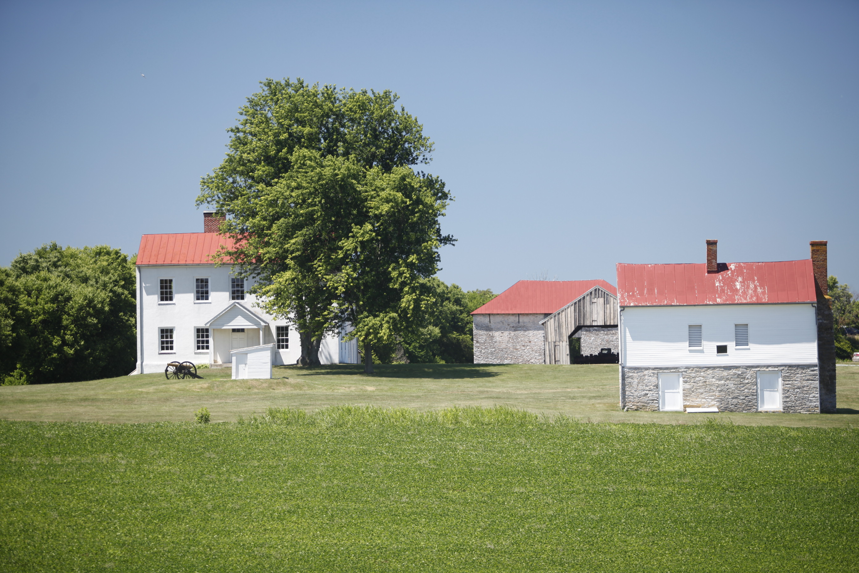
In 1860, Christian Keefer Thomas purchased a 261-acre farm called Araby. C. K. Thomas relocated his family to Frederick County to avoid Baltimore's pre-war strife; however, Arby’s location near important transportation routes and Monocacy Junction subjected it to both Union and Confederate troops throughout the war.
There are 270 words in this description. The Thomas Farm is a 237-acre farm. It is bounded on the north by the Monocacy River, on the east by Urbana Pike and Araby Church Road, to the south by Baker Valley Road, and Interstate 270 on the west. There are two entrances to the property: a driveway from Araby Church Road that leads to the park headquarters in the Thomas House and an entrance from Baker Valley Road that leads to the public parking area. The farm is an active farm. The land is divided into several fields, with some fields used for grazing, others for growing crops or native plants. The public parking area is a gravel lot next to a small cinderblock house at the edge of Baker Valley road. The house is a private residence and not open to the public. Next to the parking area are several waysides. The Thomas Farm Trail starts here. One-hundred-eighty feet northeast of the parking area are the remains of a blacksmith shop next to a small group of trees. The main cluster of farm building is 700 feet north of the parking area off of Baker Valley Road. In addition to a two-story, brick farmhouse; there is a corn crib, a stone tenant house, a well house, a shed, and a large red barn. The stone tenant house is open seasonal (spring through fall). There are restrooms, exhibits, and a water bottle filling station inside. The Thomas Farm trail follows the gravel farm lane past the red barn. The trail leads to the river before turning and making a loop around several of the fields.
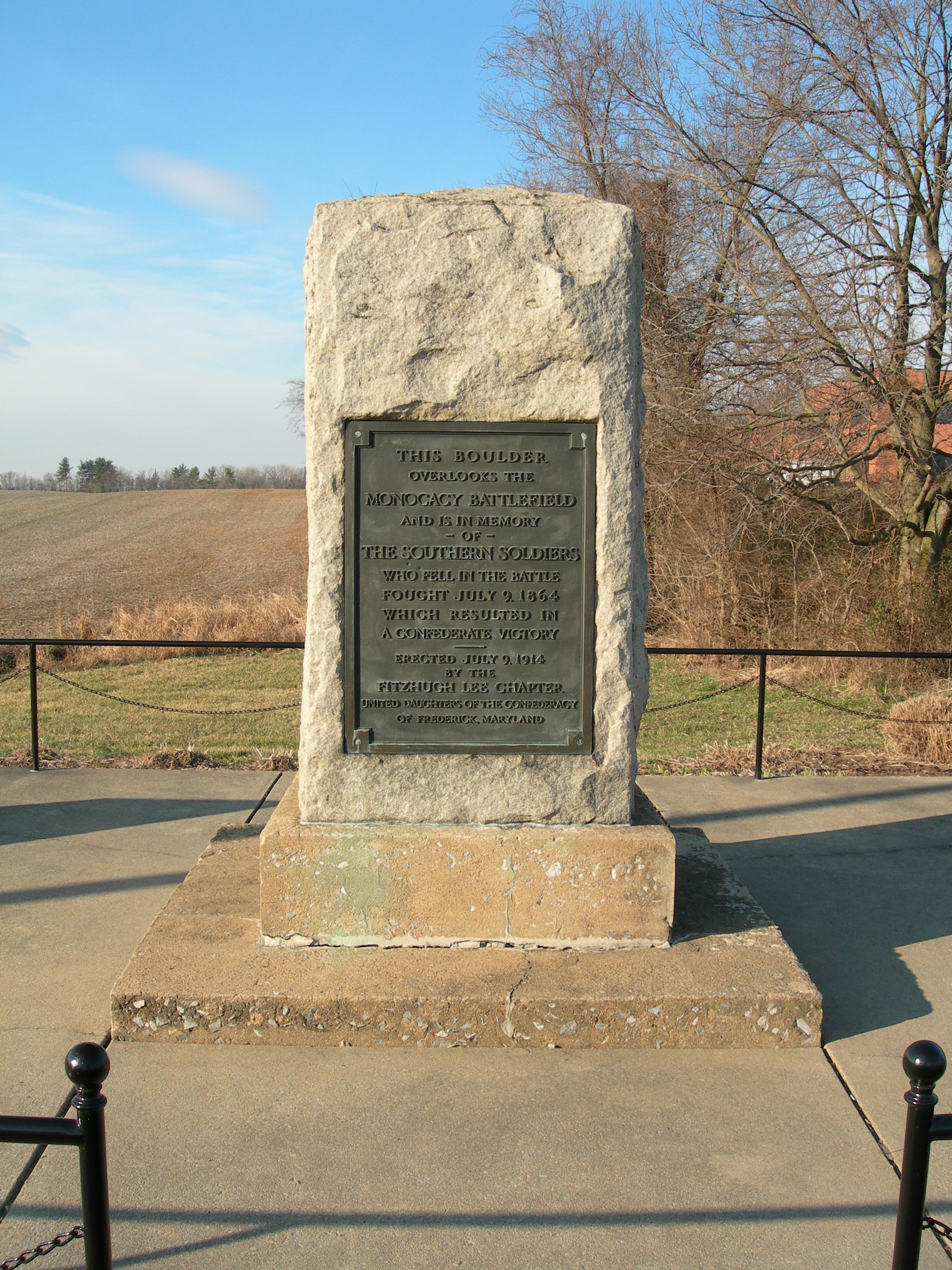
On the 50th anniversary of the Battle of Monocacy, July 9, 1914, the United Daughters of the Confederacy gathered on the side of the Georgetown Pike to dedicate a monument to the Confederate soldiers who had fought and died there. They were joined by 500 invited guests and dignitaries. It was the third monument erected on the battlefield and the only one honoring Confederates.
This description is 500 words long. The United Daughters of the Confederacy or UDC Monument is a rough cut 12- foot tall block of granite. It is 3 feet wide and 3 feet deep. The granite block sits on a square concrete pedestal that is approximately a foot tall and four feet wide. The concrete pedestal is atop a six foot square concrete base that is four inches tall. The UDC Monument is in the center of a 40 by 20 foot concrete pad. There is a rectangular bronze plaque on the front of it with writing on it. The plaque is approximately two feet wide and four feet tall. Written on the plaque is “This boulder overlooks the Monocacy Battlefield and is in memory of the Southern soldiers who fell in the battle fought July 9, 1864 which resulted in a Confederate Victory. Erected July 9, 1914 by the Fitzhugh Lee Chapter. United Daughters of the Confederacy of Frederick, Maryland.” To the south of the UDC Monument on the concrete pad sits the Maryland Monument. The Maryland Monument is a large granite block about 4 feet high by three feet wide by two feet deep. The top is slanted forward and there is a bronze tablet in the form of an open book. Etched on the front of the monument are the years “1864 – 1964.” The sides of the monument are rough cut. At the northwest corner of the pad is a Maryland historical marker on a pole. The edge of the concrete pad is ringed by a fence with an opening directly in front of the UDC Monument on the east side. The fence is made from black metal pipes. The fence is about three feet high with vertical supports approximately every six feet. Chains arcing between the vertical poles attaching about six inches below the top rail. Looking to the west over the top of the monument, is a field of crops. A line of trees borders the northern edge of the field. The ground slopes gently upward to the west, leaving just the tops of trees visible in the distance. Facing south, a two lane road stretches into the distance, disappearing around a curve to the left. A split rail fence with six rails separates the road from the field of crops to the west. Telephone poles with wires stretching between them line both sides of the road. In the far distance are tree covered hills. To the east, on the other side of the two-lane road is another six rail, split-rail fence that separates the road from a field of crops. Across the field, about 500 feet away is a barn shaped building with a green, metal roof. This is the park visitor center. Behind the visitor center trees line the edge of the field. To the north, the road expands into four lanes. Telephone poles with wires stretching between them line both sides of the road. Buildings are partially visible behind trees in the distance on both sides of the road.
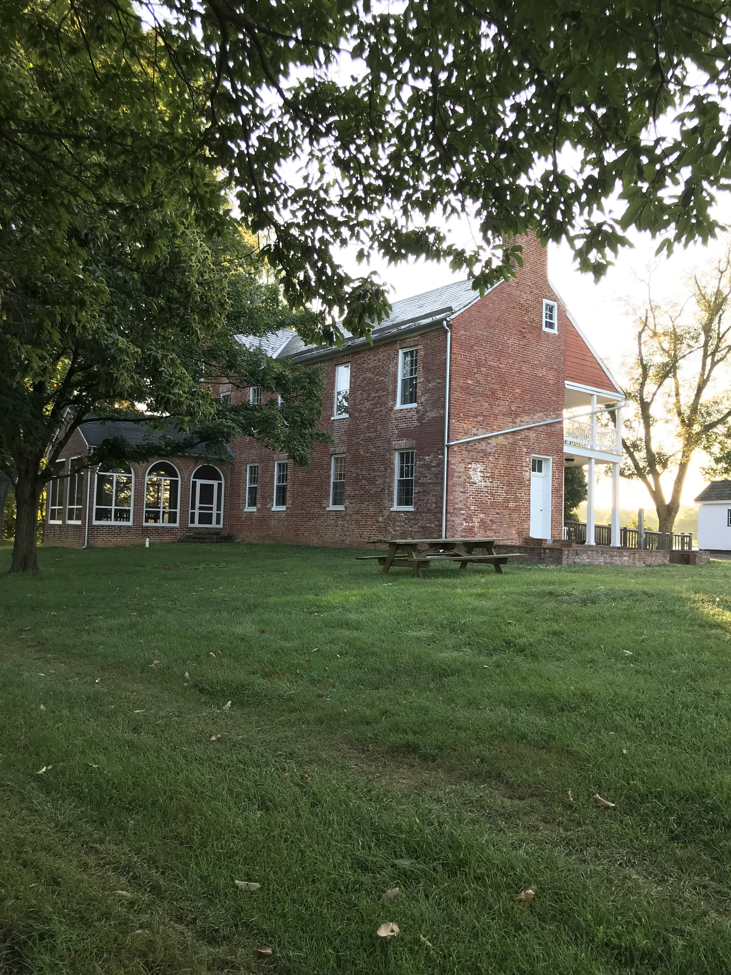
During the Battle of Monocacy on July 9, 1864, Confederate troops crossed the Monocacy River via a ford onto the Worthington Farm. From the farm fields, the Confederates initiated three advances toward the Union line positioned at the neighboring Thomas Farm. Today visitors may enjoy scenic views and hiking trails.
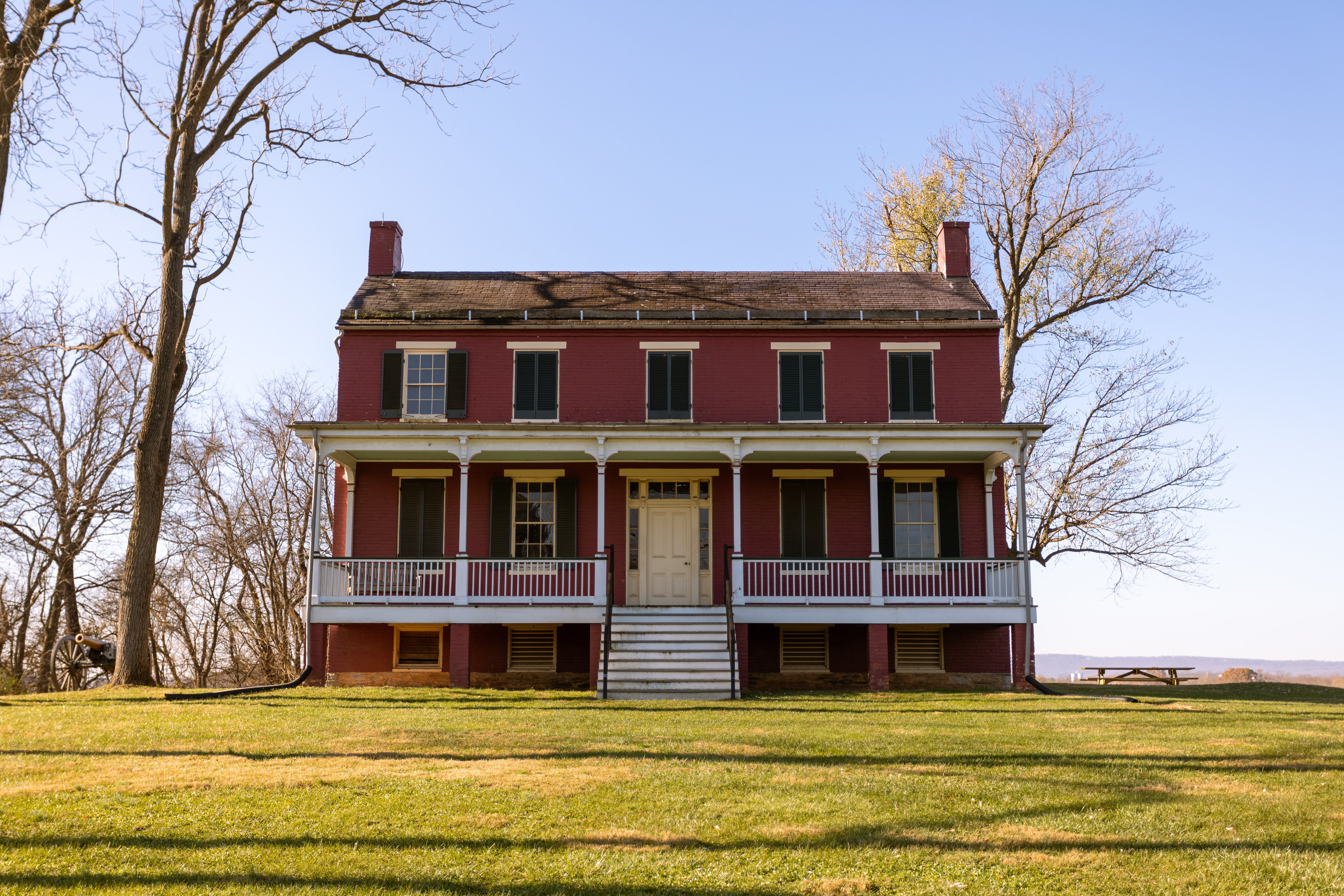
This description has 375 words. Worthington Farm is a 300 acre property that is tucked into a bend of the Monocacy River. It is bounded by Interstate 270 on the east, The Monocacy River on the north and west and the Baker Farm to the south. Brooks Hill divides the Worthington and Baker Farms. The property contains four active agricultural fields that are used for growing hay and pasturing cows. Access to the farm is via a one lane gravel farm road that runs parallel to I-270 for almost six-tenths of a mile. There is a small gravel parking lot near the entrance to the drive off of Baker Valley Road and another small gravel lot three-quarters of a mile from the entrance. At the west end of the parking area are four signs: A Bold Plan, Worthington Farm Trail, Track Trails wayside, and Service Vehicles Only. The gravel farm road continues to the west and wraps around a farm house out of sight. In the distance are the silhouettes of the Catoctin Mountain Range. Three hundred feet west of the parking area are two waysides: Through a Child’s Eyes and Ambush. One-hundred feet from the waysides is a red, brick two story farm house with a covered front porch that runs the length of the house. The house has five windows with shutters evenly spaced across the second story. On the first story the center window is replace by a door. The porch is raised about four feet off the ground. Wide steps lead up to the door. The peaked roof has chimneys at each end. To the right of the house is a picnic table. To the left of the house is a single cannon. The start of the Brooks Hill Trail is to the left (south) of the house. The Brooks Hill Trail disappears into the trees. The Ford Loop Trail and the High Water trails are to the right (north) of the house. The trail skirts the edge of an agricultural field. The farm lane continues for about half-a-mile. The edge of the road is lined with trees. There are agricultural fields beyond the trees on both sides of the road. More detailed descriptions of the waysides and house are available on the app.
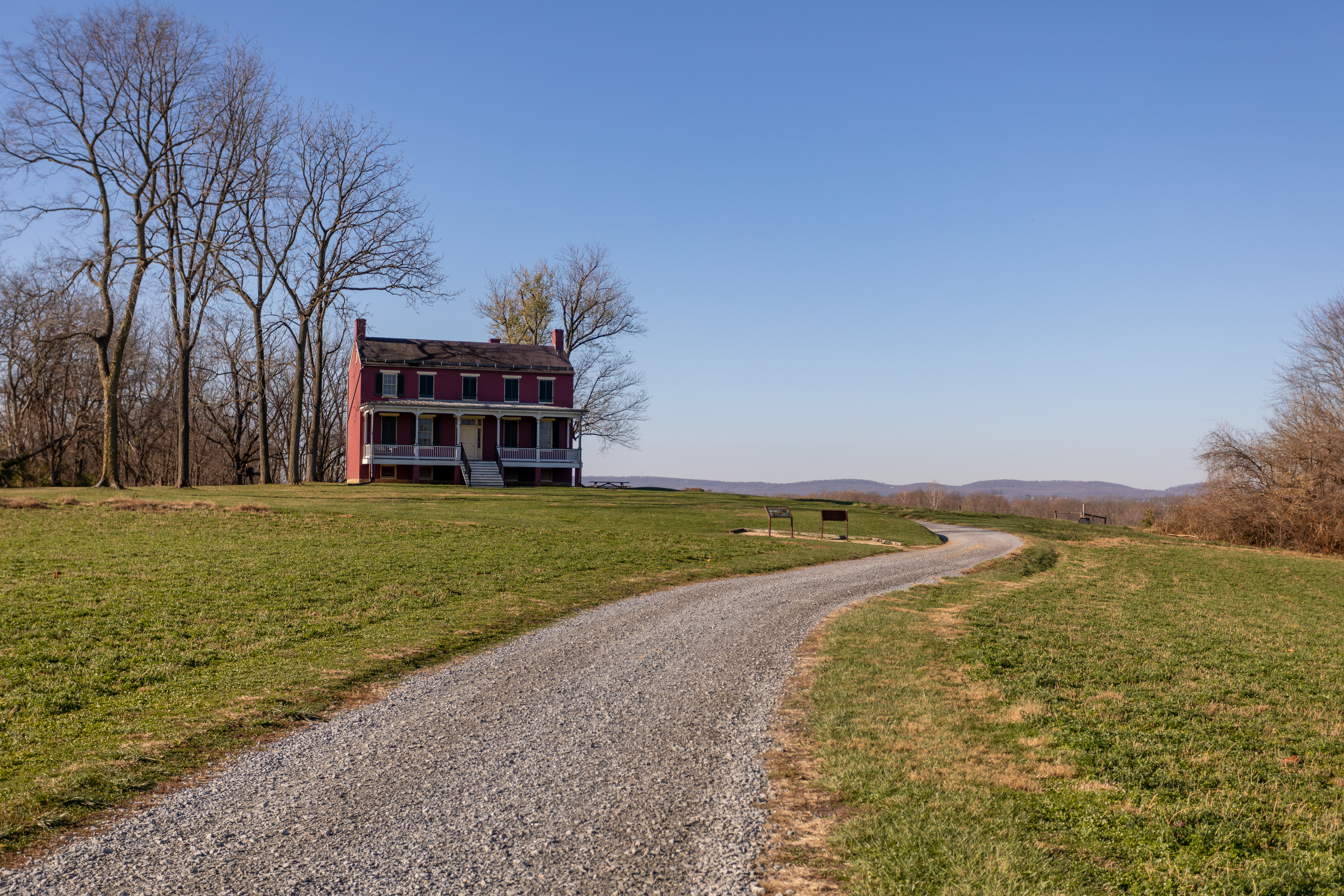
John and Mary Worthington bought the house and farm in 1862 and moved into it with their two sons, John and Glenn. In the winter of 1862–1863, Union troops camped in the area, and, while they had a major effect on the farm and the family who lived there, probably had little effect on the house. However, the Battle of Monocacy was fought around it on July 9, 1864.
Audio Description The Worthington House sits on top of a hill within a bend in the Monocacy River. The front of the building faces east and has five bays: on the second floor, there are five double hung windows; on the first floor four double hung windows with a door in the middle; and a raised cellar with five half windows. The house is shaped like an L. The exterior walls are brick painted dark red. Each window has a white stone lintel and sill, and black wooden shutters. The window frames and central door are painted white. The doorway has a decorative surround with windows across the top and down both sides of a four panel door. A covered porch spans the front of the first floor. The north side of the house has a door and two windows on the first floor, one in the east room and one in the west room with the door in the center. The door currently opens into space but there was originally either a porch or a landing and steps to the ground on this side. There are three windows on the second floor level and one in the west end of the cellar. From the west side of the house, the L arrangement of the rooms can be clearly seen as the north room juts out far beyond the south one. There is a porch within the angle of the ell allowing access to a door into the south wall of the west room and a second door in the south wall of the central hall. There are windows in the west wall of the south room and the south wall of the west room; there are also windows on the second floor above both windows and doors. There are two doors down into the cellar on this side of the house: one into the west room and one into the south room. The south side of the original part of the house has no windows or doors. The interior of the house is arranged very simply: there are three rooms on each level. Two stairways connect the first and second floors. One stairwell goes down into the cellar. The south room in the cellar is the largest of the three and is finished with plaster on the walls and ceiling. This is where the Worthingtons, neighbors and enslaved workers sheltered during the battle. The second cellar room is to the north of the first and was probably used as a storeroom. The third room, west of the second, was the winter kitchen. Between these two rooms is a stairwell to bring the food up to the family dining room. On the main floor, the south room was originally the parlor and has decorative painting on both the ceiling and the walls. There is a medallion painted in the center of the ceiling from which an oil or kerosene lamp would have hung. The edges of the ceiling have been painted to resemble decorative moldings and there is a stenciled pattern painted around the top of the walls. The woodwork in this room has been wood grained to make inexpensive moldings look like mahogany. About three feet inside the door is a short wall that was part of the Jenkins Brothers’ system to divide the room into two cubicles to house more African American migrant workers during the years of their ownership in the twentieth century. The walls of this room also bear the graphic art of those workers or others who sheltered in the house while it was closed. There is a large fireplace in the south wall but the mantel has been removed. The central hall has an open well staircase rising to the second floor, painted panels on the walls rising above the stair, and a painted medallion on the ceiling that centered another light fixture. There are decorative brackets on the side of each step and originally there were turned balusters and a curved banister with newel post on the stairs. The front door to the house is in the east wall of the hall and a second door to the west porch is in the west wall. The north room was probably used as the family dining room as it has an original built in cabinet lined with shelves in the north wall next to a large fireplace. The top shelves have grooves cut into them to hold plates upright. There are two doors on the west side of this room, both of which lead to stairwells. The stairs beyond the south door lead down to the cellar and the kitchen; the stairs beyond the north door lead up to the bedrooms. Doors on the opposite sides of the landings lead into the west room of the house. There is an exterior door to the back porch in the south wall and a large fireplace in the west wall. It is likely that sometime during the 1890s the kitchen was moved up from the basement into this room and a large wood cookstove was installed in front of the fireplace. This was replaced by a propane gas stove during the 1930s. When electricity was installed in the house in 1935, water from the well was pumped into the kitchen, but a bathroom was never installed. The original floor has been covered with at least six layers of linoleum. The second floor is divided into three bedrooms, one on each side of the central hall and the third over the west room. Access to the attic is through western room.
A bookstore, public restrooms, and an interactive museum are located within the Visitor Center. The Visitor Center is open Thursday through Monday from 9:00 a.m. to 5:00 p.m. The visitor center is closed on Thanksgiving Day, Christmas Day, and New Year’s Day. For additional information, please contact the Visitor Center at 301-662-3515.