Be advised that the NPS has issued alerts for this park.
Partial Reopening: Cross Estate Gardens
The Cross Estate gardens have reopened as of August 4. However, a portion of the trellis area remains closed due to storm damage and ongoing safety concerns. Please do not enter the roped-off section until repairs are complete.
NY Brigade bathrooms closed for three months due to renovation work
The New York Brigade Comfort Station will be closed for the next three months due to renovation work funded by the Friends of Jockey Hollow Portable toilets have been provided in the Jockey Hollow Visitor Center parking lot.
Passaic River Trail Bridge washed out
Tropical Storm Ida washed out the Passaic River bridge on the Patriot's Path Trail south of Tempe Wick Road. This area is a known habitat of the endangered wood turtle, so do not wade, walk, or let your dog run in the river at this location.
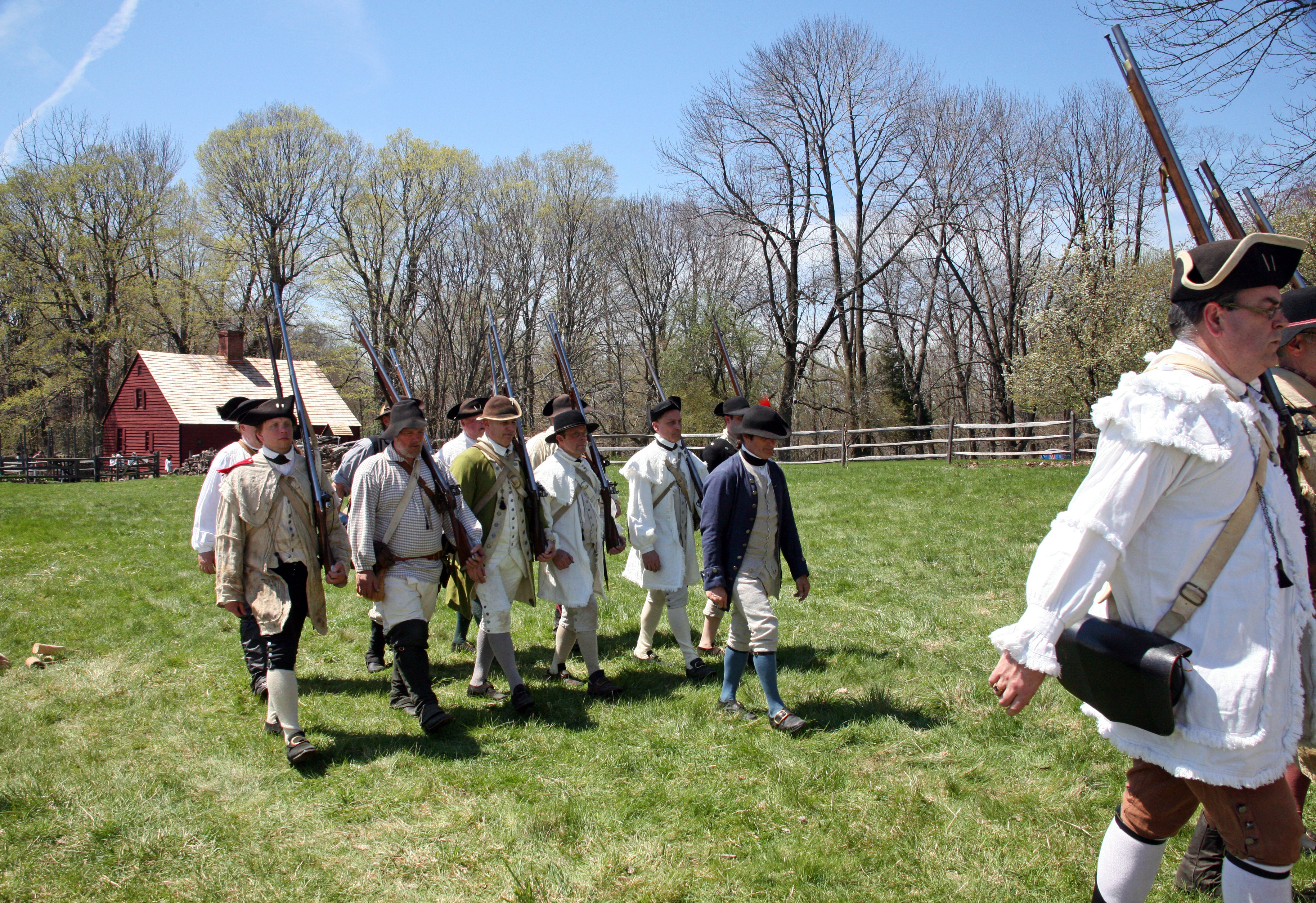
Morristown National Historical Park commemorates the sites of General Washington and the Continental Army’s winter encampment from December 1779 to June 1780, where soldiers survived the coldest winter on record. The park also maintains a museum ...
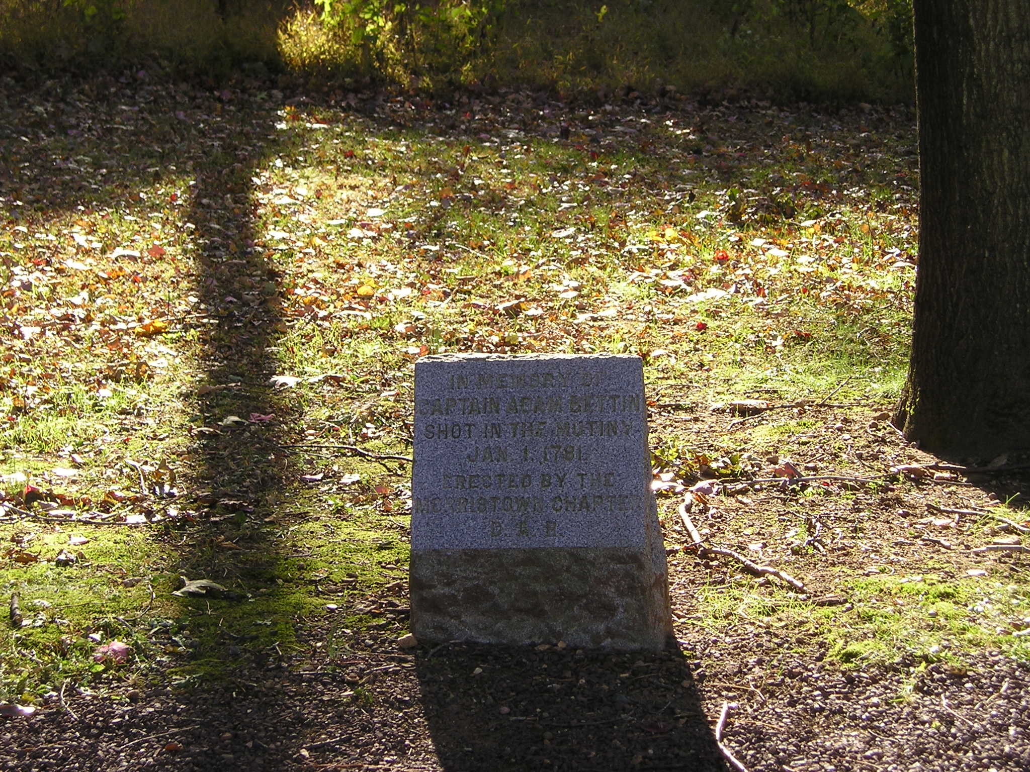
Local tradition claimed Capt. Bettin, killed during the Pennsylvania Line mutiny in 1781, was buried near a black oak tree which became known as the “Bettin Oak.”
A mature red oak tree stands behind a low stone monument marker. The tree and marker are located in a small clearing about fifteen feet around, and several feet above the nearby Jockey Hollow Road bed. The stone marker reads "IN MEMORY OF CAPTAIN ADAM BETTIN SHOT IN THE MUTINY JAN 1. 1781 ERECTED BY THE MORRISTOWN CHAPTER D. A. R."
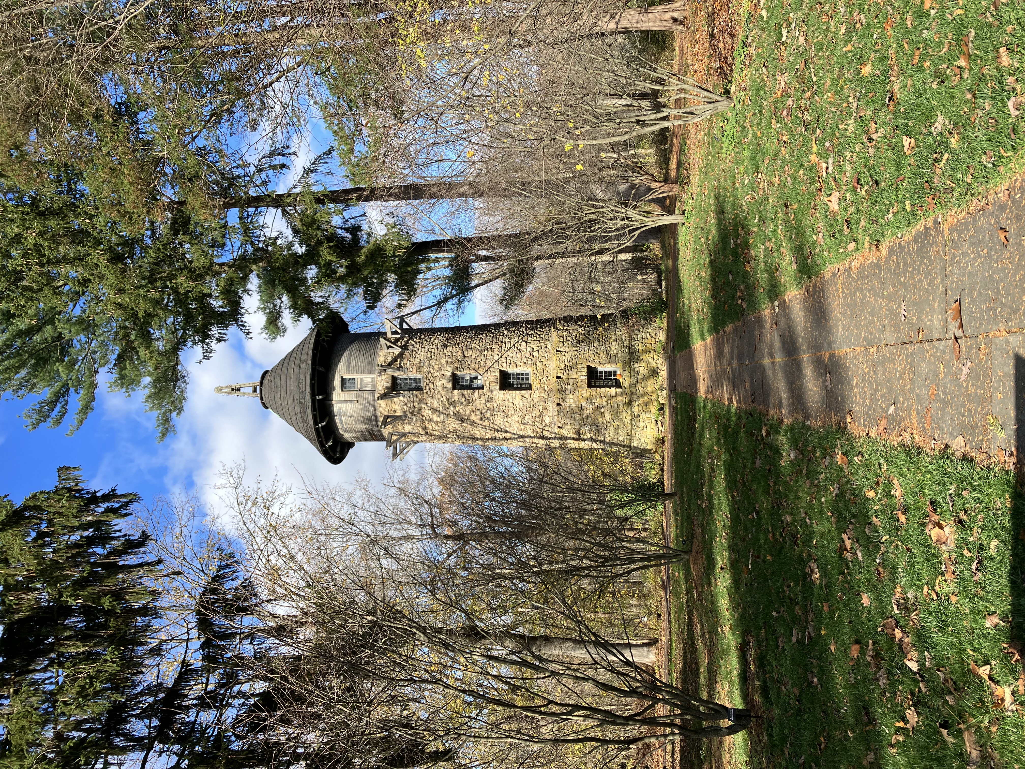
The stone water tower looms over the Cross Estate. It was used to pressure water through the plumbing of the house. Though the tower was rendered obsolete by an electric motor, the tower itself is still a monument to a bygone time.
A five-story tall round tower comprised mainly of large stones fitted together in masonry. A single column of glass windows with twenty four panes, twelve in two sashes, are set into the tower's side, one window for each story. The fifth story has a door instead of a window, and horizontal wooden . Crucially, there is no platform or any other sort of place to step to outside of the fifth story's door; it's a sheer drop down the tower. There are buttress supports that ring the tower at that level, which support no floor, or anything. The tower is capped by a conical roof with a "brim" that extends several feet out from the tower itself. At the top of the roof is a wooden structure of four wooden columns that come to a point into the sky, ringed with metal rungs. Within this is a machine column. The building shows evidence of age but not neglect. Moss creeps over the lower portions of the column, yet many stones are still clean and in their place.
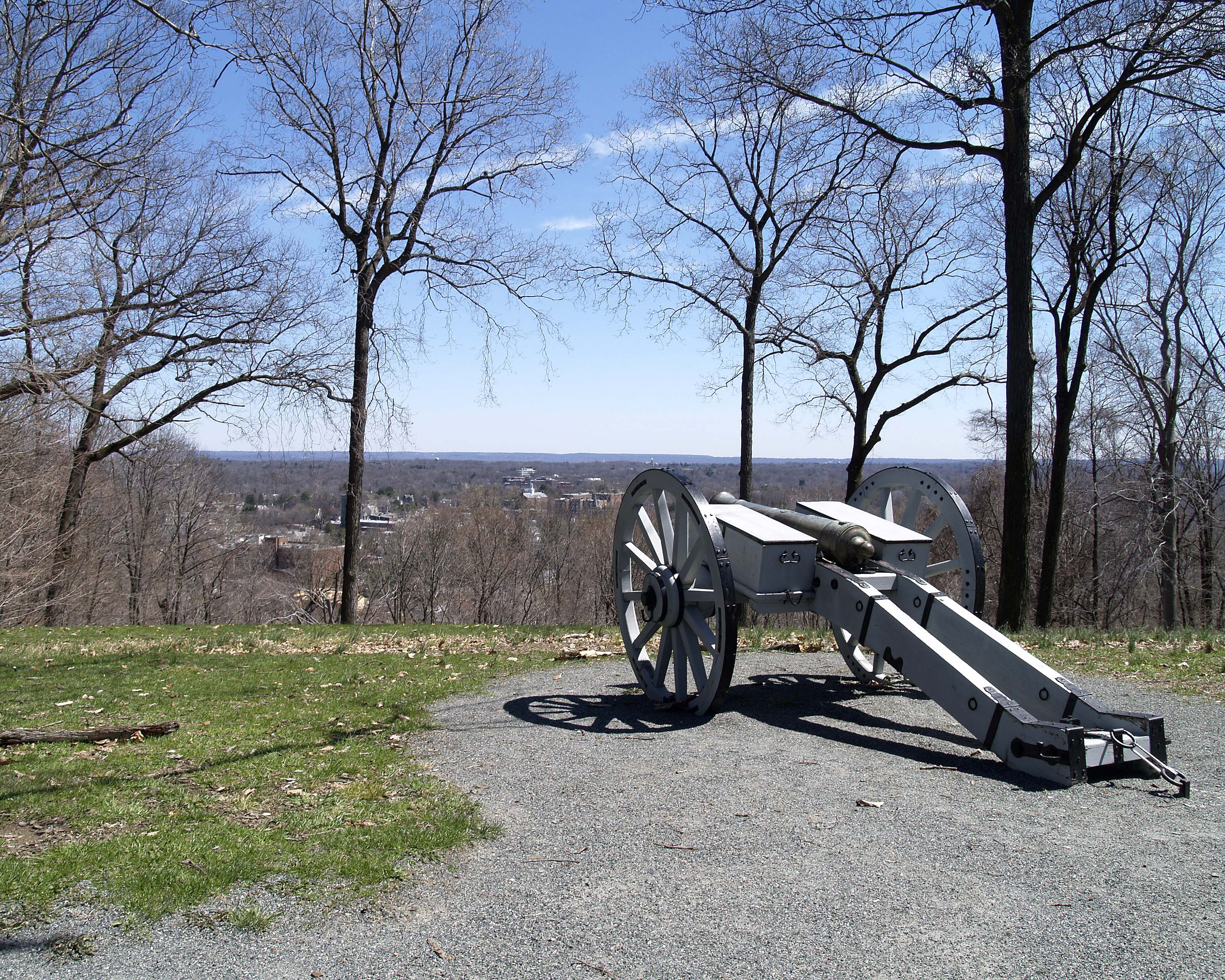
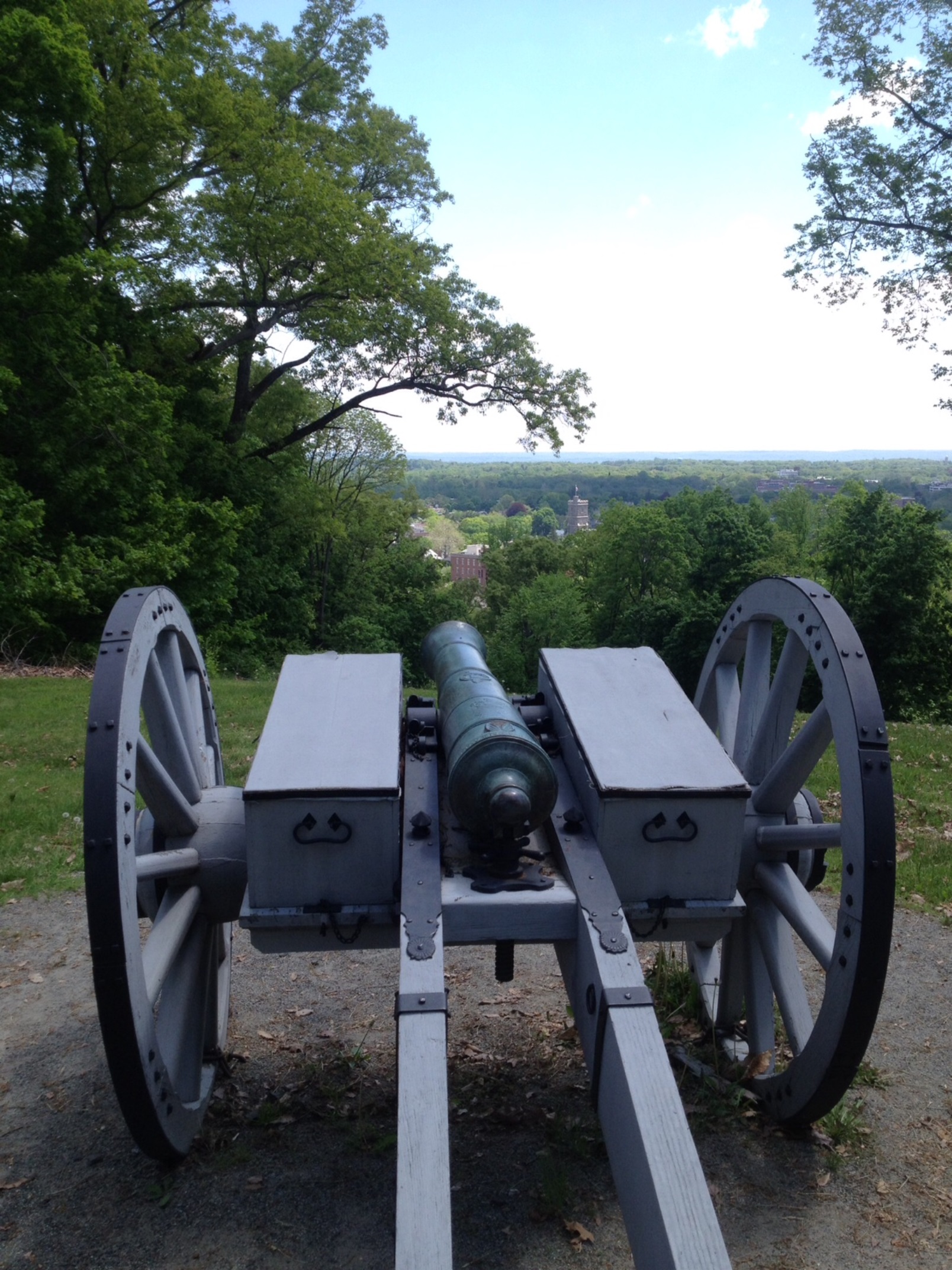
Originally referred to as “the Hill” or “Kinney’s Hill,” Fort Nonsense commanded the heights of Morristown. The function of the Fort was as an observation and alarm post, and a place of retreat for guards stationed in the town. The British never made an attack on Morristown, however, and the fortified hilltop was never used. It was common for a small fortification such as Fort Nonsense to be built for the protection of military encampments and strategic military depots.
A large wooded hilltop levels off with a parking lot, information kiosk, and picnic tables. Stone pavers set into the ground trace the approximate outline of an earthwork redoubt constructed by the Continental Army during the Revolutionary War. Nothing remains of the original fortifications. A cannon overlooks the town of Morristown below the crest of the hill, with the wooded valley below open to a scenic view from the former site of Fort Nonsense.
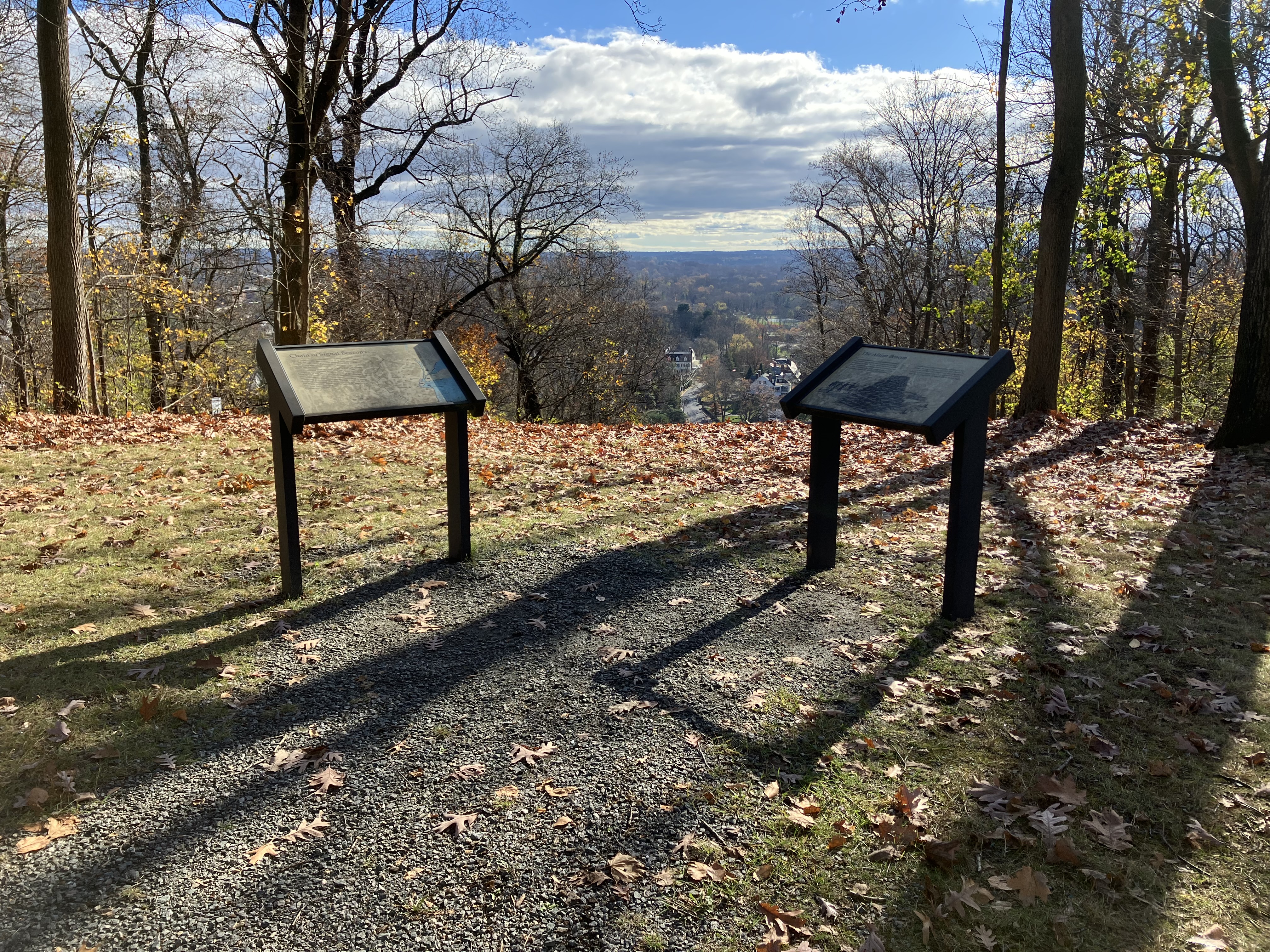
The supposed former site of a signal beacon on a prominent hill in Morristown, NJ.
Two markers at the end of a gravel path, on a hillside overlooking the road leading to the top of Fort Nonsense Hill. One marker is entitled "Chain of Signal Beacons" and depicts a map of northern New Jersey and the New York City islands. The map shows four British flags depicting British army positions in Staten Island, Sandy Hook, Brooklyn and Long Island, and Manhattan. There are five American flags showing American army positions near Freehold, Summit, and Pompton in New Jersey, as well as two positions just north of the New Jersey border in New York state on the west side of the Hudson River. There are twelve icons indicating signal fires on the map interspersed among the American positions, starting in the south with four surrounding Freehold with one of those between Freehold and Sandy Hook. Four more beacons are at Middlebrook, Pluckemin, Summit, and Morristown. Three beacons are to the north, south, and west of the American position near Pompton. The final beacon is between the two American positions in New York. The text on the panel reads "Large fires, cannon and flags were used to signal alarms during the Revolutionary War. The fires were called beacons and were used to assemble militia, indicate the approach direction of the enemy and to direct the movements of military forces. In the spring of 1779, a signal chain of log and brush pyramids was ordered built in a line along the highlands of the New Jersey coast. A beacon was to have been constructed at the "point" of this hill - a location that would seem to correspond to the area within the 1777 fortification. However, no conclusive historical documentation has been found to confirm the actual buildings of a beacon here. Looking south from this vista to the distant horizon, you can see the hill near Summit, New Jersey, on which another beacon was erected." A legend near the bottom denotes the symbols for American, British, and beacon positions. The second wayside is entitled "The Alarm Beacon" and shows an image of three Continental soldiers with a horse standing to the viewer's left next to a pyramid of logs and brush larger than they are, on a hillside of cleared stumps overlooking a colonial town below with houses and a church in the distance. The text reads "The alarm beacon was a huge pyramid-shaped structure of logs and brush usually placed on a prominent hilltop. In case of enemy invasion or other emergency situations, it was to be set on fire to notify militiamen to go to preselected meeting places and prepare for response to the alarm. Instructions for building alarm beacons in New Jersey during 1779 required that they should be "...made of Logs intermixed with Brush square at Bottom about sixteen feet & to Diminish as they rise like a pyramid & should be 18 or 20 feet high." Morristown itself is below the hill, and this section of the hill faces west by southwest, overlooking Route 202 South and the neighborhoods around it.
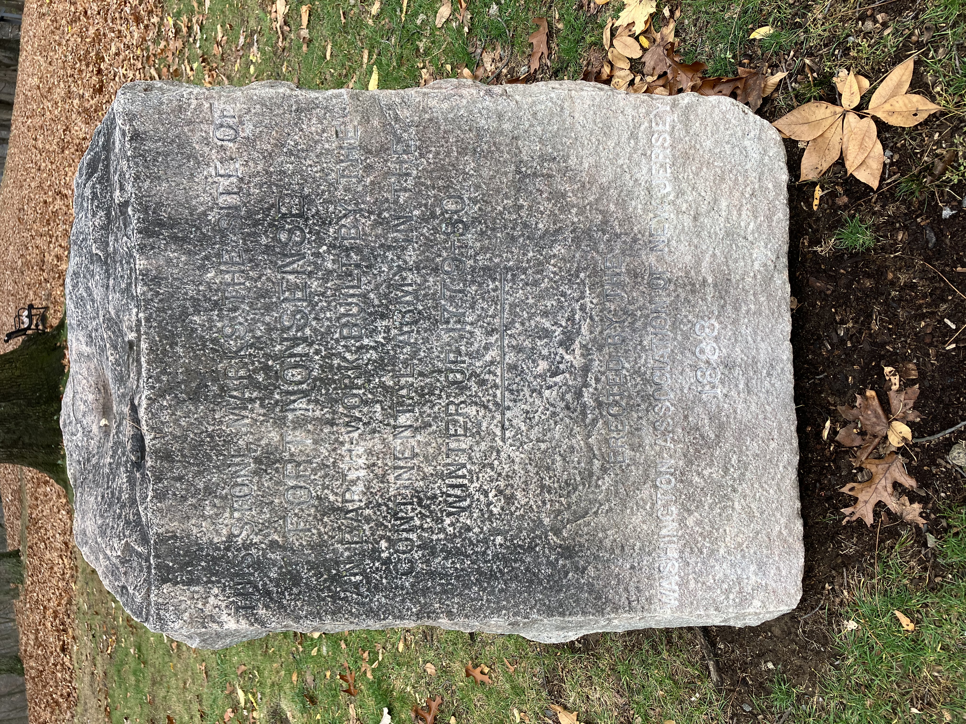
This stone marker was placed here in 1888 by the Washington Association of New Jersey to mark the site of Fort Nonsense.
A large white stone, three feet high and two feet square at the base, sits in the grass adjacent to a gravel pathway. The stone's top and sides are roughly hewn, with the exception of a flatter, still rough surface that faces the parking lot at a slightly upturned angle, tilted up to allow those standing to read the words inscribed on the face. The inscription reads "This stone marks the site of Fort Nonsense, an earth-work built by the Continental Army in the winter of 1779-80. Erected by the Washington Association of New Jersey 1888." The stone shows signs of age and weathering, with many of its edges smoother
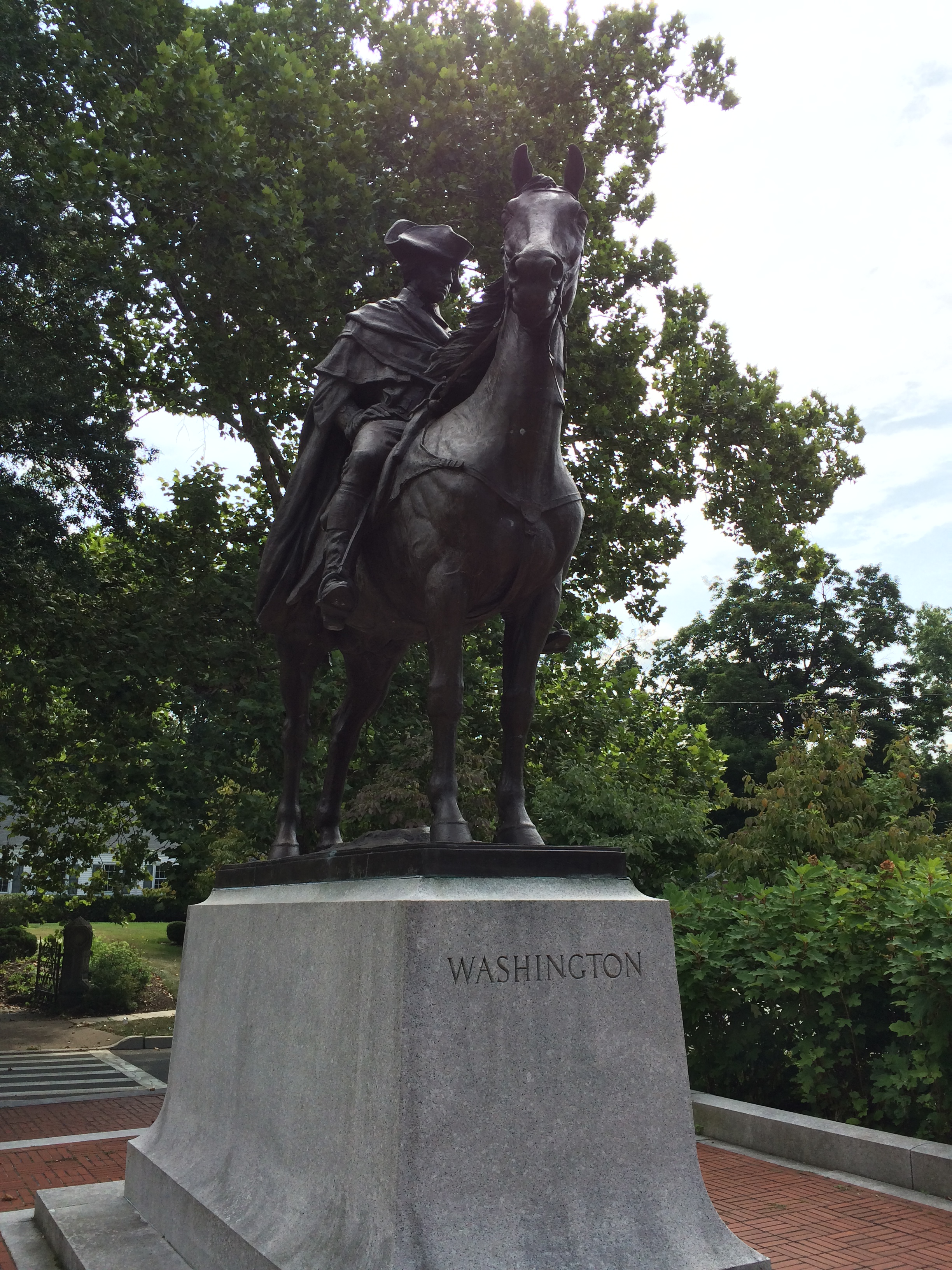
The statue of George Washington sits just across the street from the private home he used as his headquarters for an uncommonly hard winter during the Revolutionary War.
A triangular island of land between roads hosts a small pavilion with a low wall surrounding it. A large lifesize bronze statue of a man on a horse stands atop a four foot high stone pedestal in the center of the triangle, facing northwest. The pedestal's inscription reads "Washington" on the front, and the back reads "Headquarters at Morristown / January - May 1777 / December 1779 - June 1780"
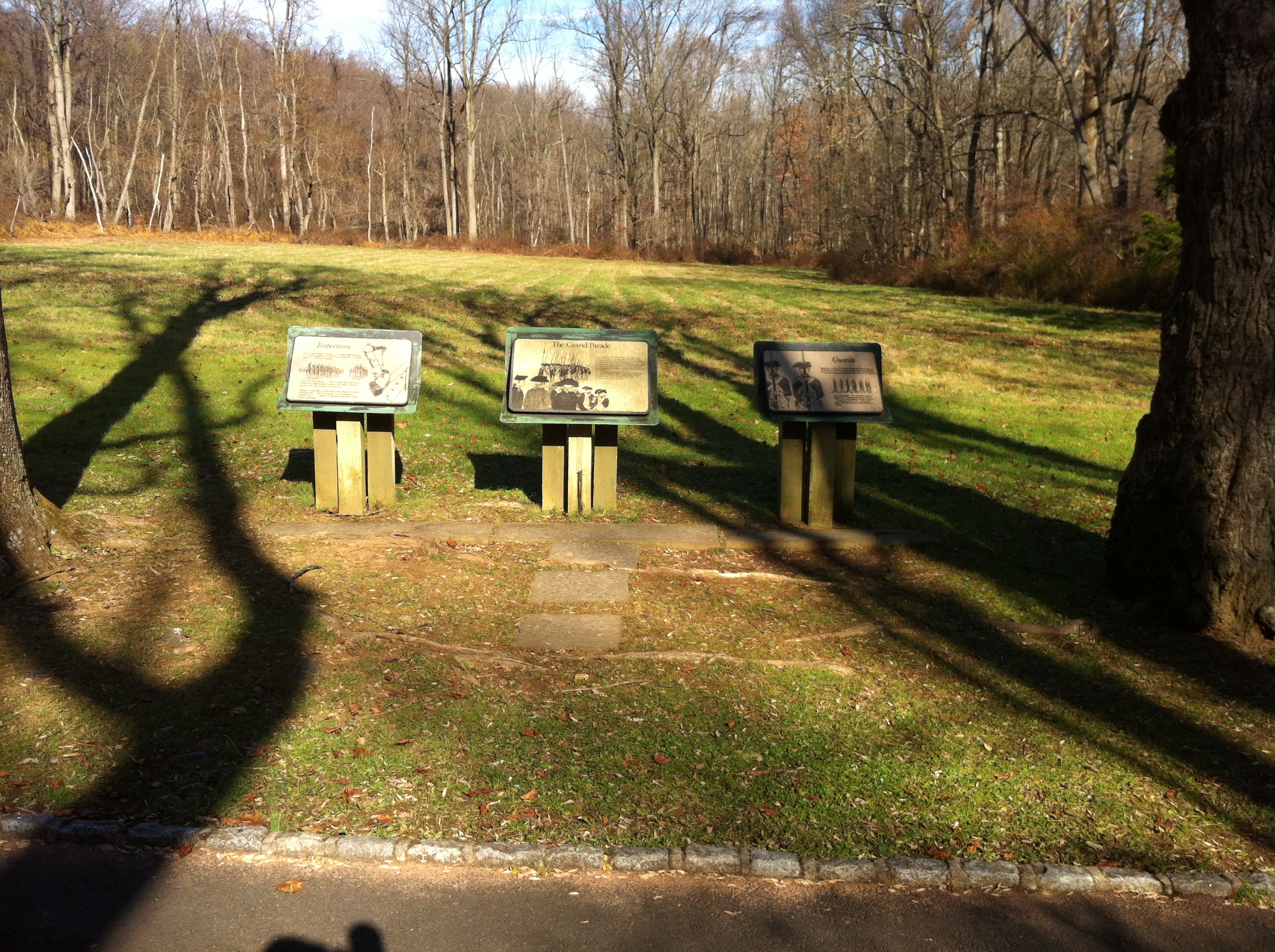
The Continental Army used the Grand Parade ground for a variety of purposes, including troop assemblies, reading of general orders, and inspections.
A clearing about sixty yards square sits on the north side of Grand Parade Road as it passes through the forest. The clearing is surrounded by forest and undergrowth otherwise. A concrete platform set into the grass before three wayside exhibit signs describing the area, which read as follows: "INSPECTIONS Faces and hands washed...beards clean shaven...hair combed and tied if long enough...shoes clean...clothes brushed... And catridge boxes...Washington worried often about catridge boxes. Unless they kept a soldier's powder dry, his musket was useless. Despite every effort, cartridge boxes often fell short of standards...lack of money and shortages of leather. So...a captain inspected cartridge boxes every morning." "The Grand Parade A focal point of the sprawling "log cabin city" at Jockey Hollow was the Grand Paradge. Each day, guard details assembled here for inspection, and General Orders from Washington's headquarters were distributed. This was also the site of formal military reviews. And it was here that those guilty of serious crimes were executed and buried. The original Grand Parade was located beyond this open ground, in the woods to the north. It was 400 yards long and 100 yards wide - six times the size of this clearing." "Guards Each day's guard reported here for inspection, a short drill, and the daily parole and countersign. From here the relieved the previous day's guard. The camp guard --- 17 men from every 2 regiments --- surrounded Jockey Hollow with a chain of sentinels. A picket guard --- 2 officers and 50 men --- assembled daily and "lay on their arms" waiting for orders."
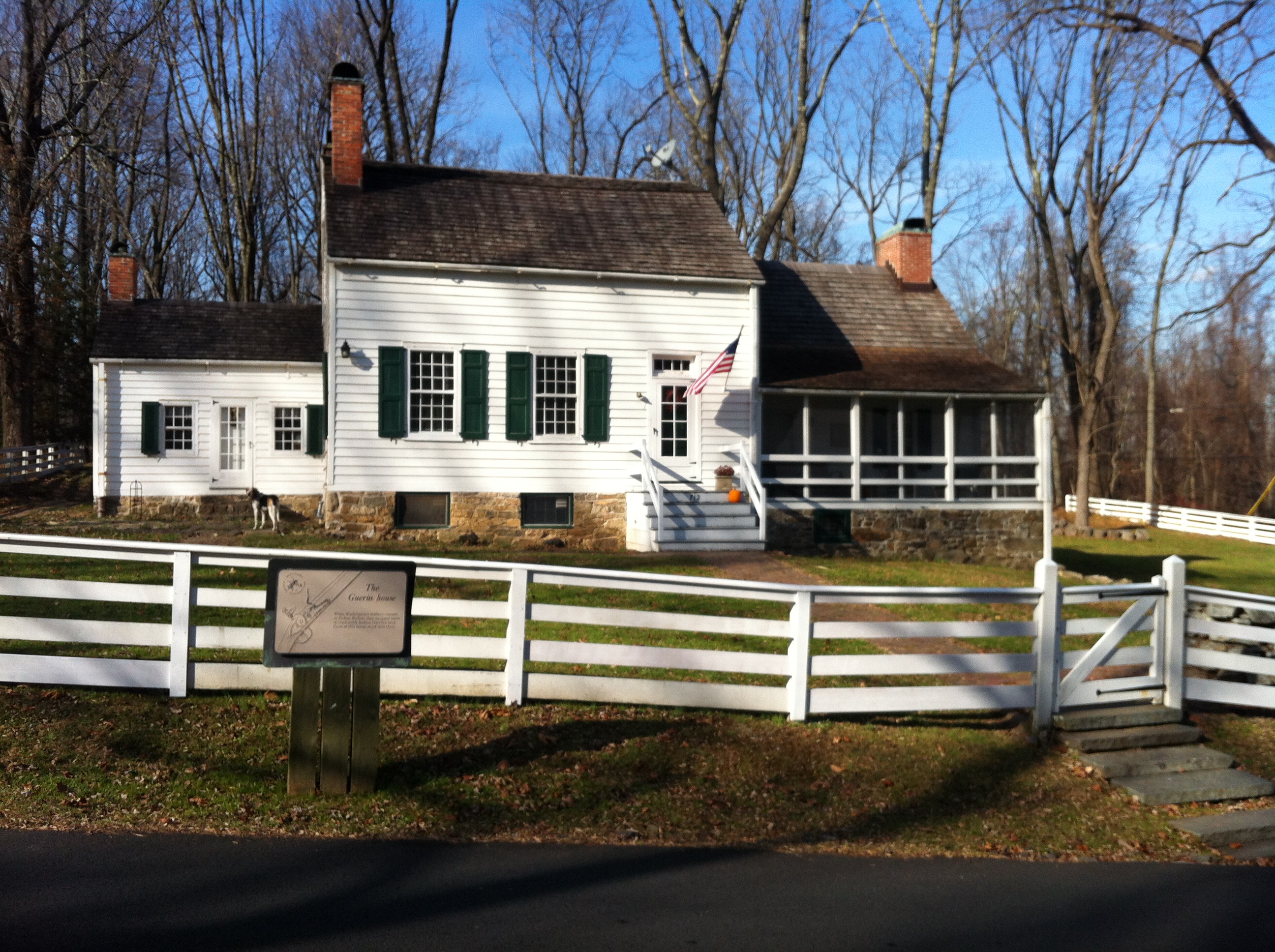
Historic home of Joshua Guerin, blacksmith and member of the state militia, located near the winter encampment of the Continental Army in Jockey Hollow near Morristown, New Jersey.
A white two story farmhouse with green shutters and a stone foundation. There are two additional wings to the building, one on the north side with a screened in porch and another to the south face set back from the front door by several feet. Brick chimneys emerge from the roof of each wing. A short set of stairs leads up to the front door of the house. Despite the home's historic appearance, touches of modernity, such as electric lights and satellite dishes, indicate the home is currently occupied. The yard extends several meters in all directions, and is encircled by a white three rail fence. A historic wayside sits on the side of the fence nearer to the public road, and reads: "The Guerin House When Washington's soldiers camped in Jockey Hollow, they occupied parts of blacksmith Joshua Guerin's land. Parts of this house stood here then."
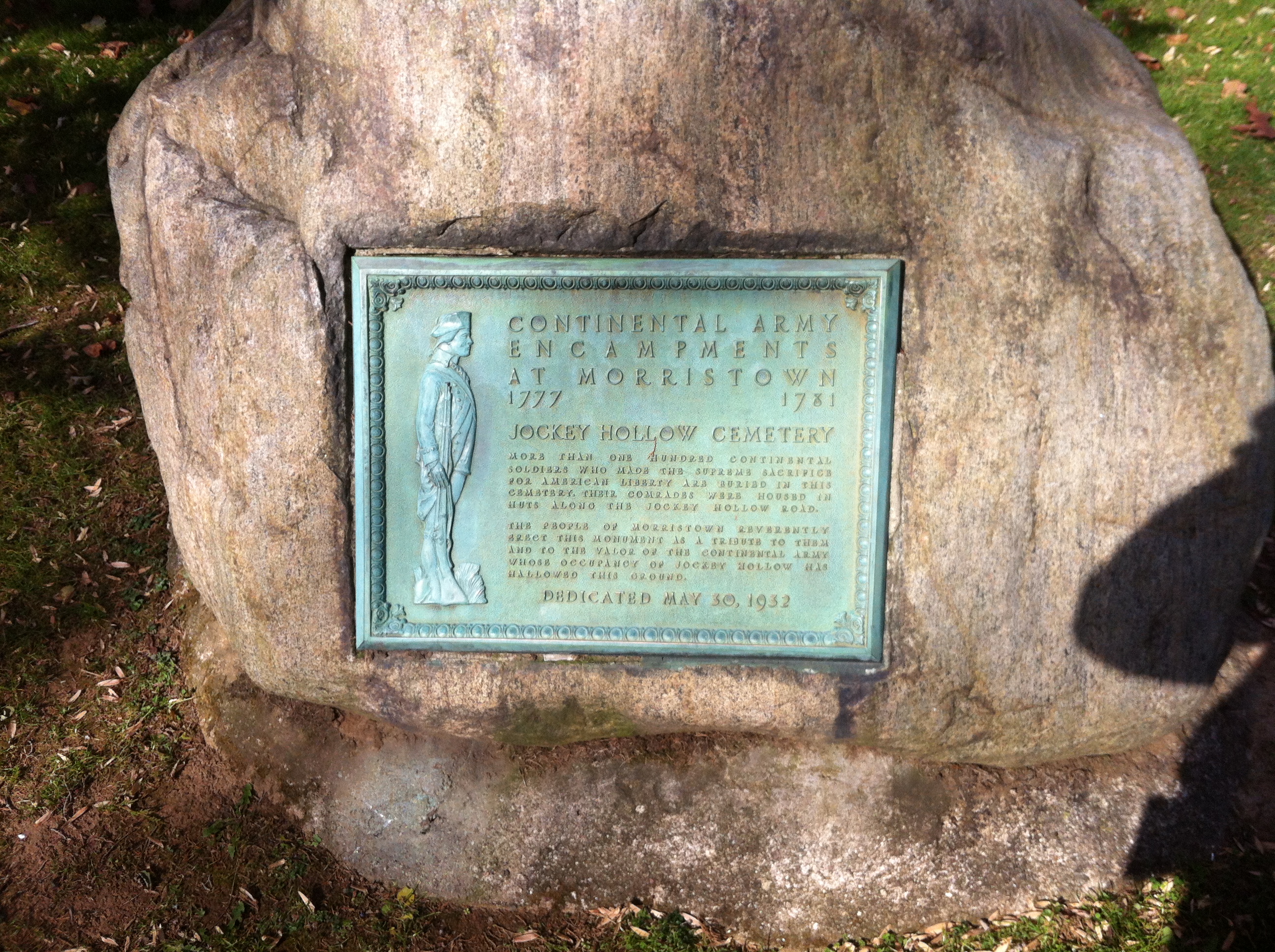
This historic marker describes a cemetery for soldiers in Jockey Hollow. Recent scholarship suggests that such a cemetery was unlikely to exist according to common military practice at the time.
A low stone sits in the grass near a few cedar trees by the south edge of Cemetery Road. The face of the stone has a plaque set into it depicting an American Revolution soldier at attention, and reads as follows: "CONTINENTAL ARMY ENCAMPMENTS AT MORRISTOWN 1777 1781 JOCKEY HOLLOW CEMETERY More than one hundred Continental soldiers who made the supreme sacrifice for American liberty are buried in this cemetery. Their comrades were housed in huts along the Jockey Hollow Road. The people of Morristown reverently erect this monument as a tribute to them and to the valor of the Continental Army whose occupancy of Jockey Hollow has hallowed this ground. DEDICATED MAY 30, 1932"
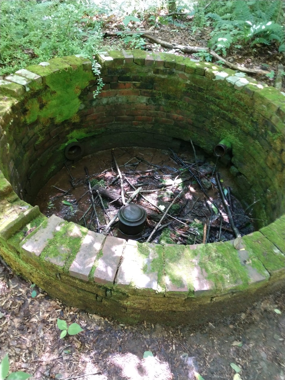
This brick vault was part of a series of ponds, trenches, and vaults owned and operated by the Morris Aqueduct Company, in order to bring fresh clean water from the hills to their subscribers in Morristown.
A ring of bricks five feet in diameter and one foot high form a vault that extends two feet into the ground. The top of the vault is open and exposed to the elements, and so the base of the vault is covered in dirt, leaves, sticks, and other sorts of forest debris. A few rusty metal pipes are evident in the walls of the vault, extending unseen into the ground around. Moss and biofilm grow over the bricks, and the mortar between has started to crumble away.
This simple marker denotes where the log huts of George Washington's Life Guard once stood during the Continental Army's use of Morristown as a military headquarters and encampment site. Washington's quarters, the Ford Mansion, stands today across the street.
A large stone with a flat face rests in the grass at the corner of two sidewalks that border the nearby church, along Morris Avenue and West Valley View Drive. The rock is nearly two feet tall, with a rough surface. The plaque is made of weathered oxidized copper. The left side features a full body of a Continental Soldier wearing their uniform in profile facing right standing at attention with the butt of their musket resting on the ground. The text of the plaque takes up the rest of the space. It reads "Continental Army Encampments At Morristown 1777 1781 Life Guard Camp On this site the Commander In Chief's Guard was encamped from December 1779 to June 1780. The Guard was reorganized in Morristown during the first Encampment in 1779 and again in 1780. Washington made his headquarters in the Ford House opposite. Erected in 1932, by Tempe Wicke Society, Children of the American Revolution."
This site marks the expected location of the New Jersey Brigade's hutting and encampment site during the Continental Army's winter quarters in 1779 and 1780. Little remains of the huts apart from conspicuous piles of stones and the possible remnants of soldiers' trash pits.
This wayside marks that the French army under Rochambeau passed through Morristown - and many other sites - along with the American army on their way to and from the climactic siege of Yorktown.
A large metal exhibit panel sits on the side of the path leading to the front door of the nearby Ford Mansion. Its surface shows a map, a detailed view of the New Jersey region, an illustration, a sidebar, and descriptive text. The text reads "On August 28, 1781, 5500 French troops under the command of General Jean-Baptiste Donatien de Vimeur, comte de Rochambeau marched on the road before you on their way to Yorktown, Virgina. They had spent the previous night in Whippany, New Jersey. After passing through Morristown, they camped at Bullion's Tavern in present-day Bernards Township. General George Washington's Continental Army took a different route, slightly southeast, and spent the night of August 28th in nearby Chatham. The Washington-Rochambeau National Historic Trail follows the routes used in 1781 and 1782 by the American and French forces to travel to and from the successful siege of Yorktown, Virginia. In a decisive victory, they captured the British Army under General Charles Cornwallis, who surrendered on October 19, 1781. This network of roads and water trails travels over 700 miles through nine states and the District of Columbia. Take this Revolutionary Route and explore historic sites and communities that once hosted Revolutionary War soldiers. Learn the stories of people who helped pave the way to victory and an independent United States. For more information about this National Historic Trail, visit www.nps.gov/waro" and it is here the descriptive text ends. The sidebar is entitled "A Powerful Partnership" and consists of two sections. The first is entitled "George Washington 1732 - 1799" and reads "Congress chose George Washington to command the Continental Army in 1775. His strategic insight and leadership culminated in American independence. After the war, Washington resigned his military command. He became the first President of the United States in 1789." A portrait of George Washington in military uniform is next to this text, accredited to Charles Wilson Peale, 1787 and courtesy of Pennsylvania Academy of the Fine Arts, Bequest of Mrs. Sarah Harrison (The Joseph Harrison, Jr. Collection). The second portion is entitled "Jean-Baptiste Donatien de Vimeur, comte de Rochambeau: 1725-1807" and reads "The French nobleman and distinguished officer was appointed commander of the French army sent to America to fight the British. After success there, he continued his military career until 1792. Arrested in 1794 during the French Revolution, he was released later that year and retired to his estates." A portrait next to this text depicts Rochambeau in his military uniform, and is accredited to Charles Wilson Peale from life, c. 1782, courtesy of Independence National Historical Park. An illustration running along the bottom third of the exhibit panel depicts the French forces in camp. Men in uniform assemble in the foreground before officers mounted on horseback with musicians equipped with drums standing at the ready. A variety of uniforms and regimental flags suggest the significant nature of the armies. The background of the illustration shows more companies and regiments of men assembling and marching between rows and columns of tents arranged in good order. The illustration is captioned "The encampment of the French Army at East Hartford, Connecticut, in 1782." and is accredited to David. R. Wagner (detail) courtesy of Dr. Frank T. Bumpus Collection of the Hudson River Valley Institue at Marist College. The map depicts the National Historic Trail route and the eastern colonies from Massachusetts down to eastern Virginia, as well as parts of the surrounding colonies and the Atlantic Ocean. The trail consists of five lines: a solid blue line for the French Army, a dotted blue line for the French Army water route, a solid red line for the Continental Army, a dotted red line for the Continental Army water route, and a solid grey line for Interstate 95. The red and blue lines separate from Boston, with the red proceeding west and blue going south along the coast. The lines converage and separate again and again, with multiple lines of each color spreading from certain cities along the way. The two colors converge at Princeton in New Jersey and remain together from there down to Yorktown, Virginia. The water routes proceed primarily down through the Chesapeake Bay and its inlets from Philadelphia, Delaware and Maryland. Ther is also a red water route from Albany down to Newburgh along the Hudson River. Major cities along the routes include Boston, Providence, Springfield, Hartford, Newbergh, Morristown, Princeton, Trenton, Philadelphia, Wilmington, Christiana, Elkton, Baltimore, Annapolis, Washington D.C., Mount Vernon, Fredericksburg, Williamsburg, and Yorktown. New York City is near the lines but none pass through it, as it was fully occupied by the British Army at the time. The scale of the map is one inch equals 40 miles, or 5 centimeters equals 40 kilometers. The map's orientation is skewed just slightly west of north. The detail window of the map shows the New Jersey section of the Trail. The detail starts at Trenton in the south and goes north to White Plains and Suffern in New York. The red and blue lines proceed along a north-south axis through the colonies, with the red lines along making several independent lines east of the main combined lines. The combined line runs from Suffern south through Pompton, Whippany, Morristown, Bullions Tavern, Somerset Court House, Princeton, and Trenton. An icon depicting French army campsites is at each of these cities, except Suffern and Morristown. The red lines alone go through Chatham, Newark, and New Brunswick. The blue line alone also passes through White Plains in New York. Other cities on the map include New York City, Elizabeth, and Perth Amboy. The map's scale is one half inch equals ten miles and is oriented to the North.
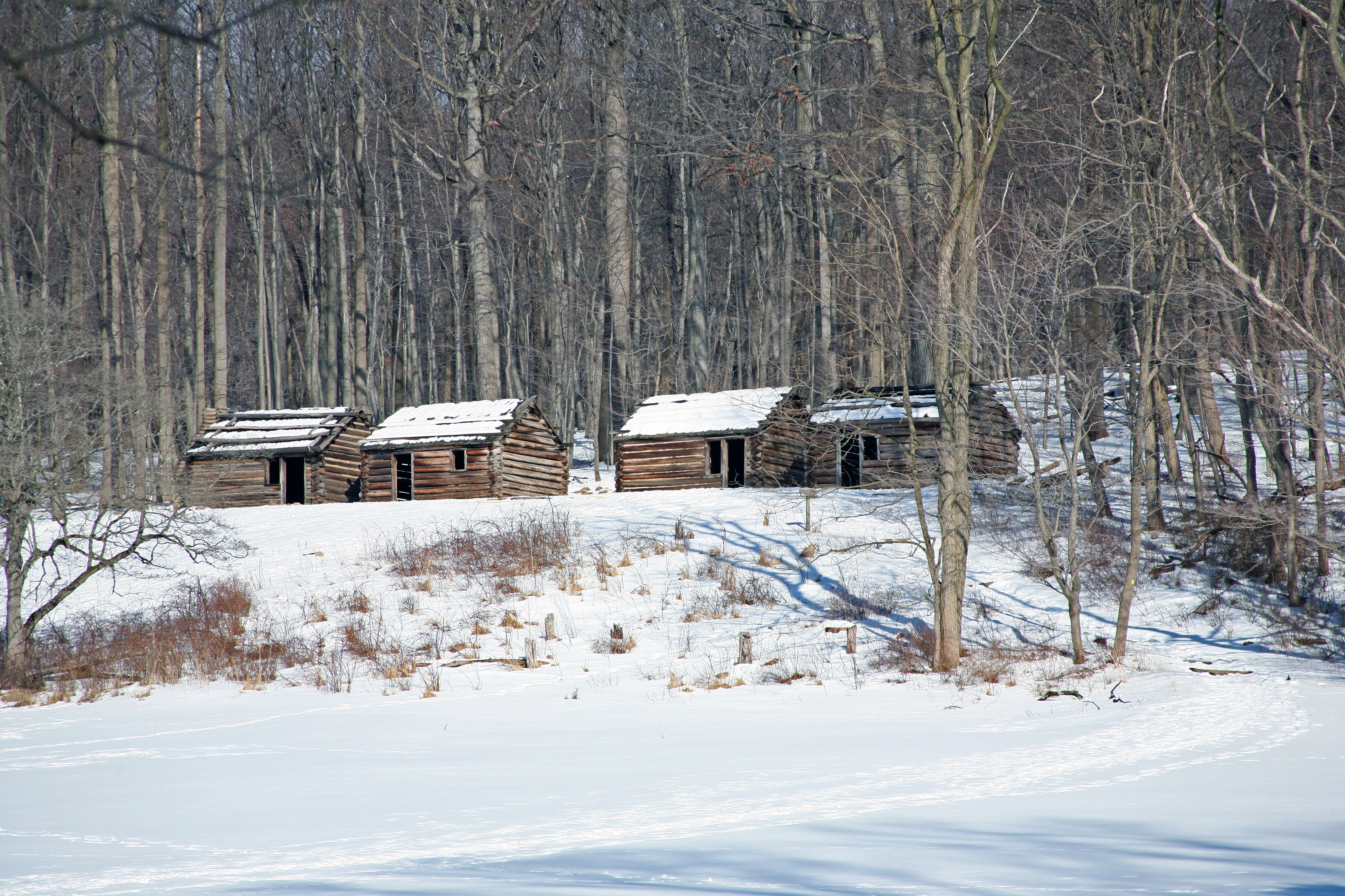
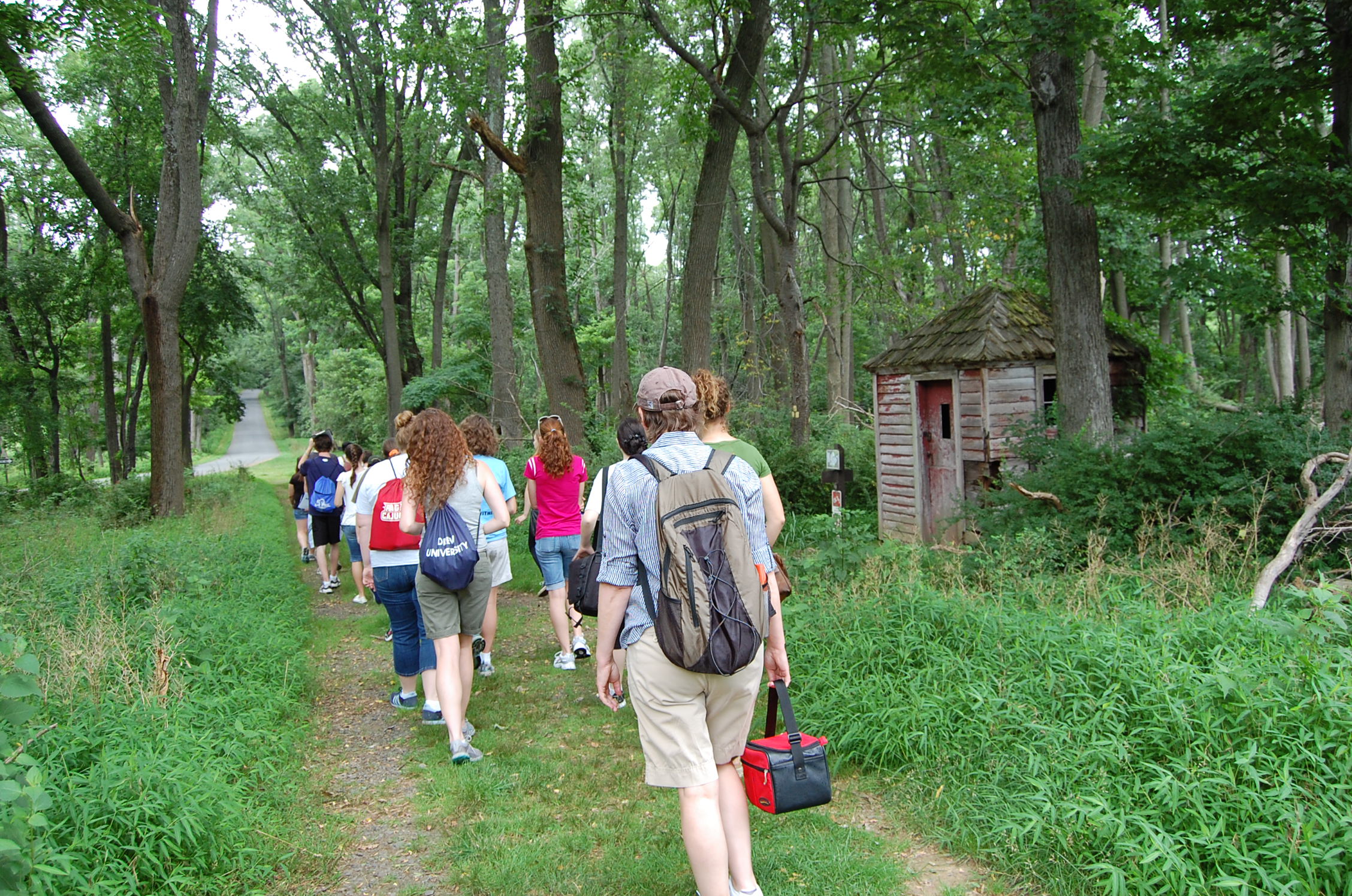
These reproduction soldier huts show the living conditions of the Continental Army soldiers encamped in Jockey Hollow during the Revolutionary War.
A large hillside cleared of trees on the southern face, with four wooden log huts on the ridge just outside of the nearby tree line. A gravel path leads from the bottom of the hillside to the front doors of the huts, which face down the hill. Each hut is a replica of the others, placed side by side in a neat row. The huts feature an empty frame to serve as a window, a doorway, and a stone hearth for a fireplace.
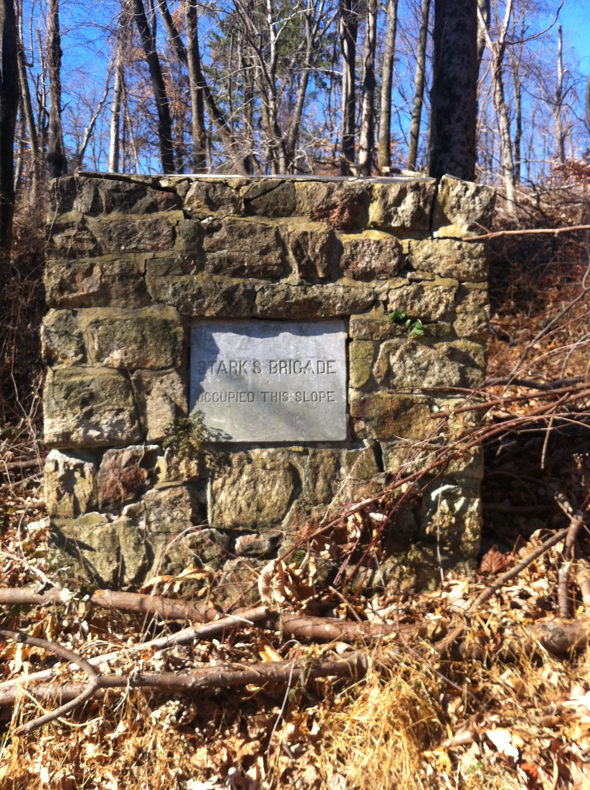
This historical marker sits on a slope away from the center of the Jockey Hollow encampment. It denotes the presence of Stark's Brigade, of the Continental Army, here during the 1779 Hard Winter encampment.
A sloping mountainside features a wide bridle trail with a park bench and several wayside exhibits nearby. The scenic view from the backside of this slope, Mount Kemble, spreads out over the valley below, broken up at the horizon by mountains rising above the land. The monument itself is built of field stone and mortar, about three feet on all sides, shaped like a cube. A flat grey stone is set into the side of the cube facing the downslope, with the following inscription: "Stark's Brigade Occupied This Slope"
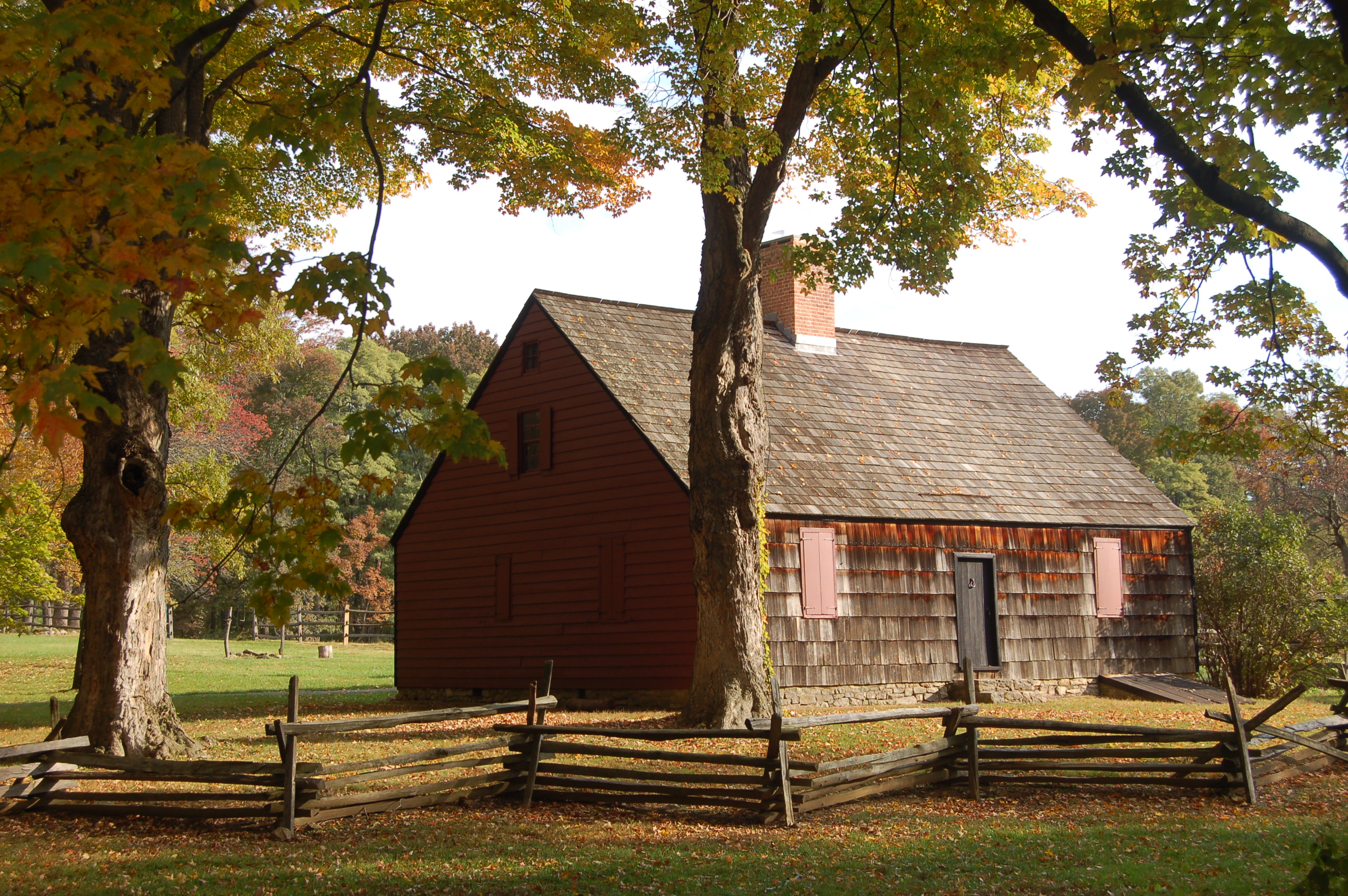
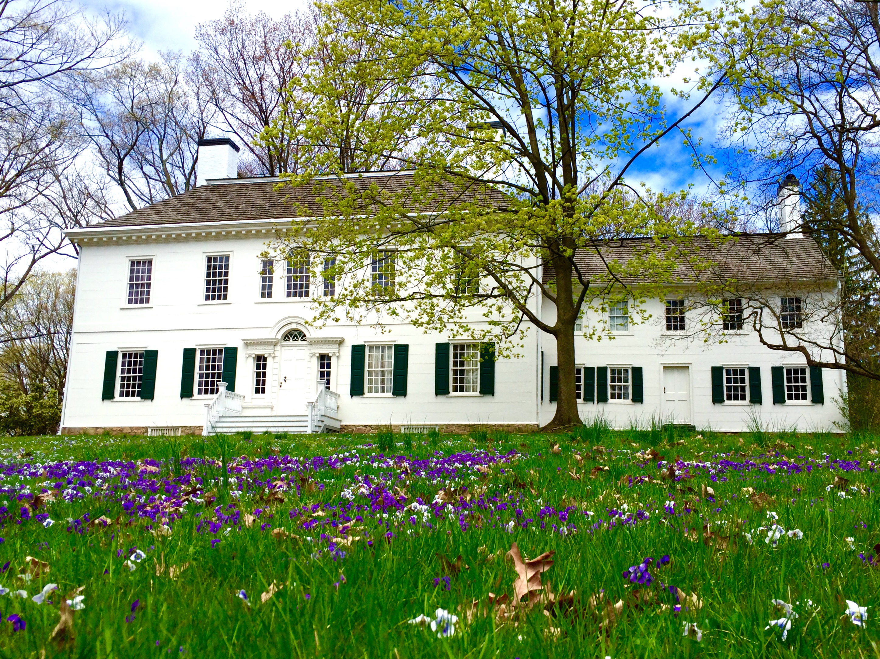
Henry Wick built this Cape Cod Style house around 1750. His 1,400 acre farm, most of which was covered by forest, made him the largest landowner in Morristown. During the winter of 1779-1780 the Continental army encamped on Mr. Wick's property, constructing log huts to endure the worst winter in living memory. The Wick family hosted General St. Clair in their home during this time.
A farm home with stone foundation and wooden sides painted red, with a wood shingled roof and a brick chimney. A stone path is laid around the house. Two simple windows flank the doors on the north and south faces of the home. A large tree sits near the home, and a wooden split fence surrounds the home about 20 feet away.
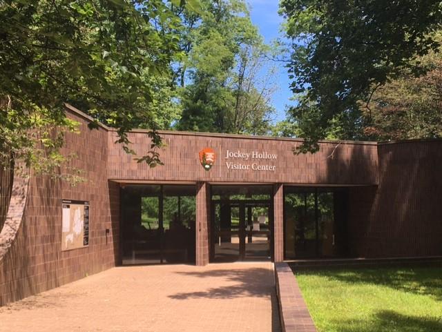
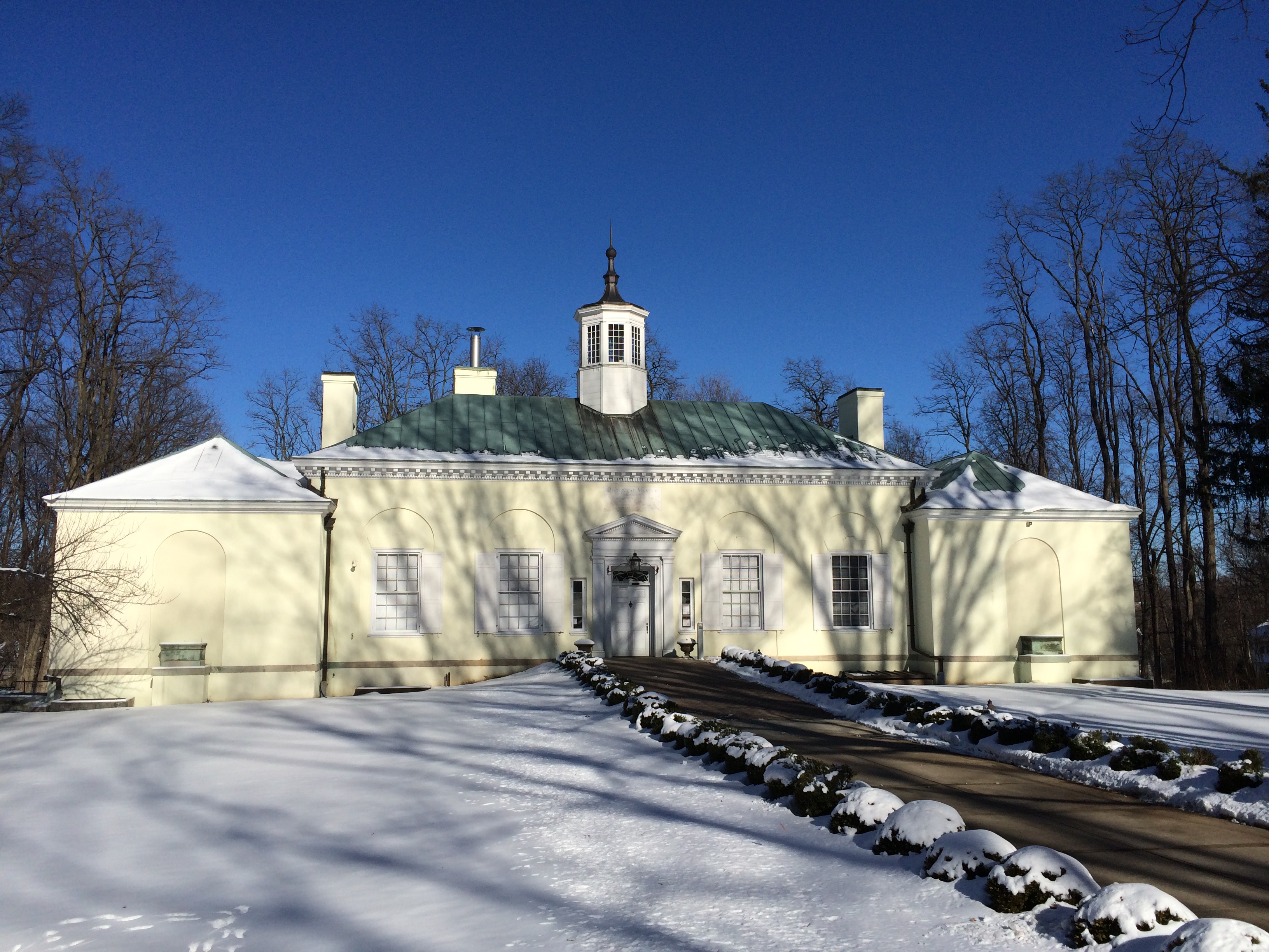
This one story brick and glass structure came to the park during the preparations for the Bicentennial. Inside, visitors will find an information desk, bookstore, a painted mural depicting Jockey Hollow during the 1779 encampment, and a full scale replica of the log huts Continental Soldiers lived in. Guided tours of the nearby Wick Farm House usually begin here. The restrooms can be accessed from the exterior doors, and remain open after the visitor center closes.
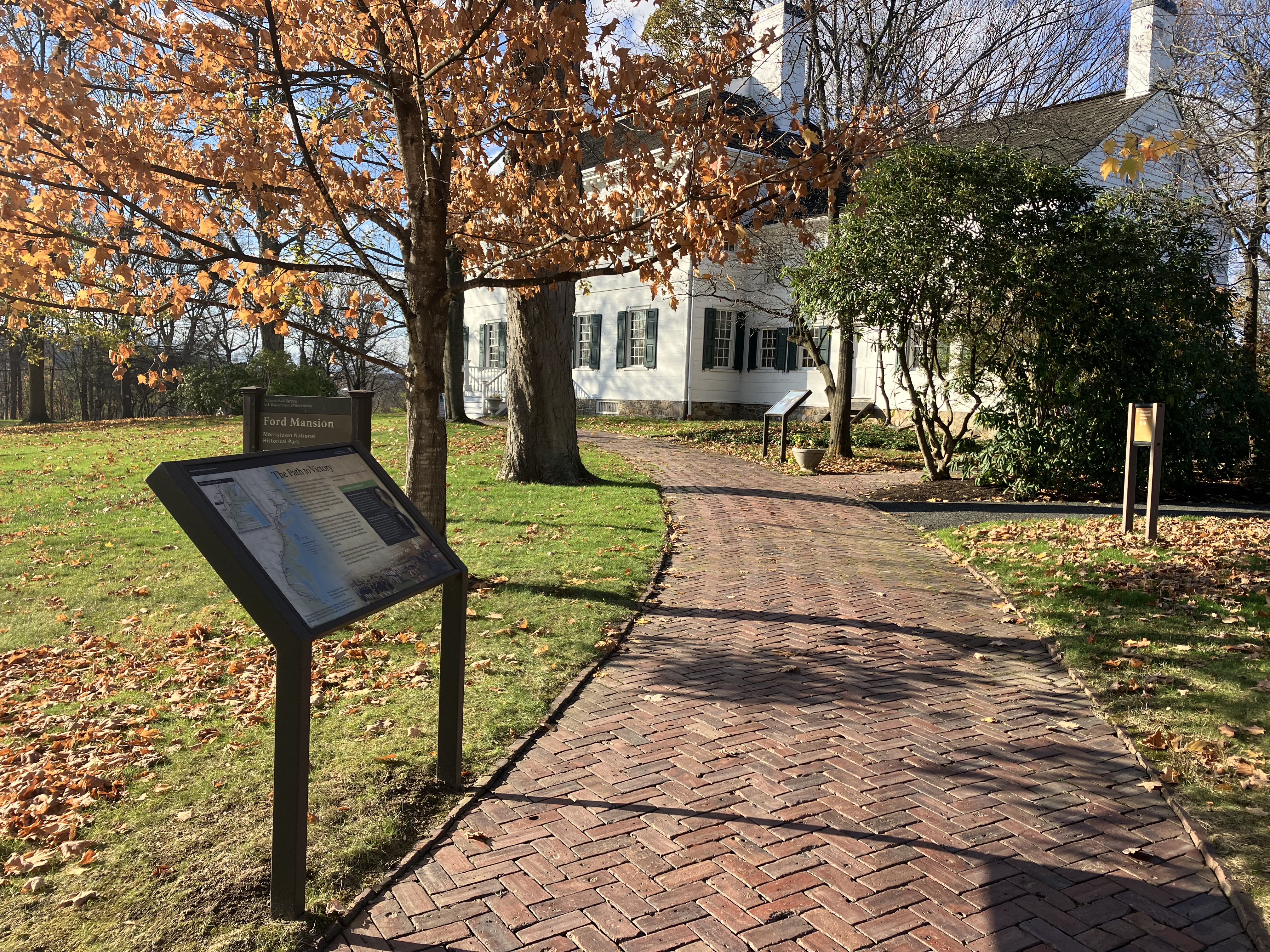
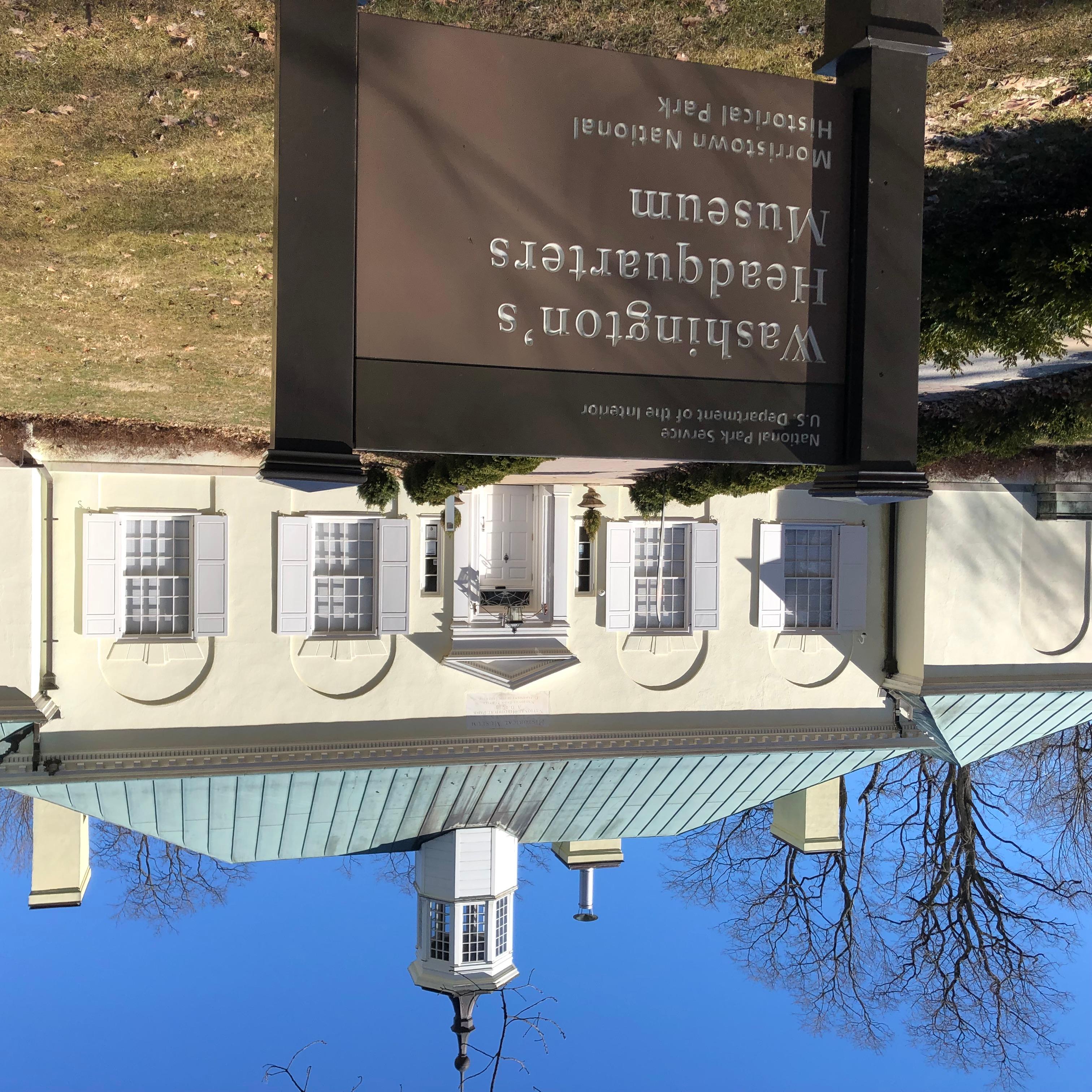
Built by the National Park Service in the 1930s, the Washington's Headquarters Museum contains numerous artifacts about the American Revolution. There are three galleries, an auditorium, a theater, and the Discover History Center. The museum often hosts special exhibits and programs. Situated just behind the historic Ford Mansion that served as Washington's headquarters for six months, guided tours of the home begin in the museum as well.
Visit Washingtons Headquarters Museum in Morristown NJ
The museum is a free of charge, self guided tour.
Go on a Guided Tour of the Ford Mansion
The Ford Mansion can be seen by guided tour only so take advantage of the opportunity when you can! Explore the home that George Washington made his headquarters during the winter encampment of 1779-1780. Discover how the Ford family adjusted to the changes to their household during what would become the coldest winter in recorded U.S. history.
Drop By Fort Nonsense in Morristown
Fort Nonsense, located in downtown Morristown, is often overlooked by park visitors, but since this small piece of the park boasts one of the best views in the area. It’s also the only officially designated picnic areas of the park. Drop by Fort Nonsense for a picnic and take in the views of the Morristown and the Watchung Mountains. If you look hard enough, on a clear day you just might see Freedom Tower (World Trade Center 1) in New York City peeking up from the horizon.
Explore the Cross Estate Gardens and Hike to the NJ Brigade Encampment Site
You can go in any order once you arrive at the New Jersey Brigade Encampment Area and Cross Estate Gardens. The hike is approx. 1 mile to reach the encampment site (note: it is downhill going out, uphill coming back).
Experience Jockey Hollow
Come explore Jockey Hollow! Check out the Visitor Center, drive, walk, or bike the 3-mile tour road loop, or hike some of the over 27 miles of hiking trails.
Tours
Count: 2
"Park and Peek" Quick Driving Tour
If you do not have much time to explore Jockey Hollow on foot, this tour will guide you to several notable points using the Driving Tour Road and parking lots.
Monuments, Markers, and Memory
This tour highlights out-of-the-way sights that many visitors miss on their first visit. In particular, this tour explores the various ways people have commemorated the history of the park, and what has survived over the years, and what has gone missing. The park is made of four different units, and you'll visit all of them by the time we finish. Access to an automobile is highly recommended.