Be advised that the NPS has issued alerts for this park.
Friday, September 26 - Visitor center and bookstore closure
Tumacacori National Historical Park's visitor center and bookstore will be closed Friday, September 26 for bookstore inventory. The mission grounds, garden, museum, and trails will be open normal hours, 9:00 am-5:00 pm. Admission fees will not be charged.
Tumacácori sits at a cultural crossroads in the Santa Cruz River valley. Here O’odham, Yaqui, and Apache people met and mingled with European Jesuit and Franciscan missionaries, settlers, and soldiers, sometimes in conflict and sometimes in coope...
The community used this small church under the guidance of Jesuit priests for ten years, until the Jesuits were expelled in July 1767. Father Custodio Ximeno was the last Jesuit to serve at Guevavi and Tumacácori. He performed his last service here on June 14, 1767, just six weeks before his arrest at Guevavi and his subsequent exile.
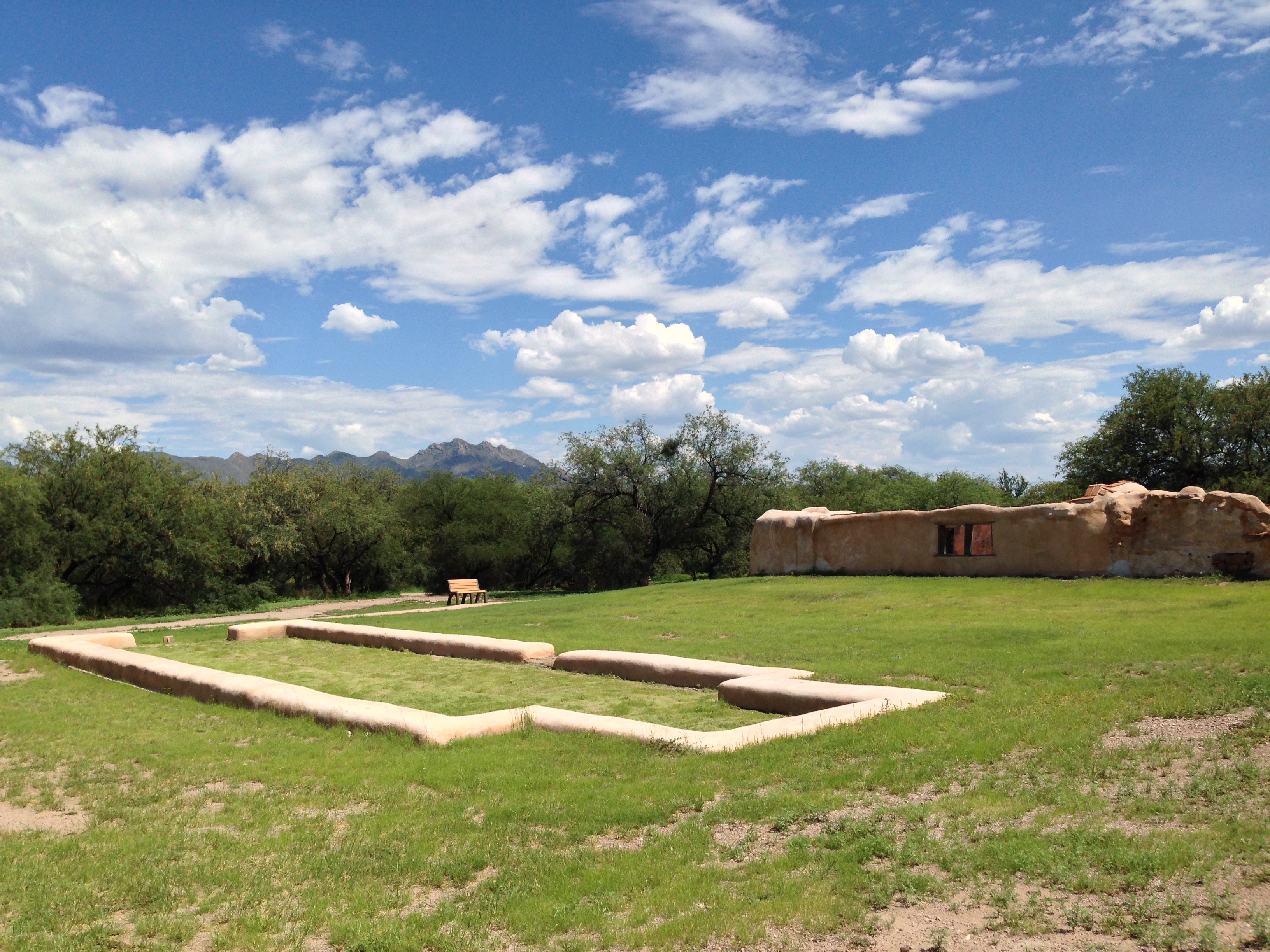
Rising from an open area east of the church and north of the convento fragment this structure appears as a low, rounded, smooth, plaster-covered wall about 2 feet thick and about 1 foot tall. It appears as a rectangular, plastered, stone outline about 50 feet long and about 15 feet wide protruding from the otherwise flat soil and sparse vegetation of the park grounds. There is an opening in the eastern width of the foundation outline about 5 feet wide, indicating where the main doorway once was. The sight of the Jesuit church footprint from the eastern side is dominated by the background view of the imposing and contrastingly preserved structure of the more recent Franciscan church. With its bell tower on the left and sacristy dome on the right, it overshadows the simple, low rectangular outline in front of you.
Guevavi is a name derived from the O'odham word for big spring, ge'e vavi, or big well, gu waihe. This settlement of O'odham people was first visited in January 1691 by Catholic Jesuit Father Eusebio Francisco Kino. It became a pivotal location in the Pima Revolt of 1751.
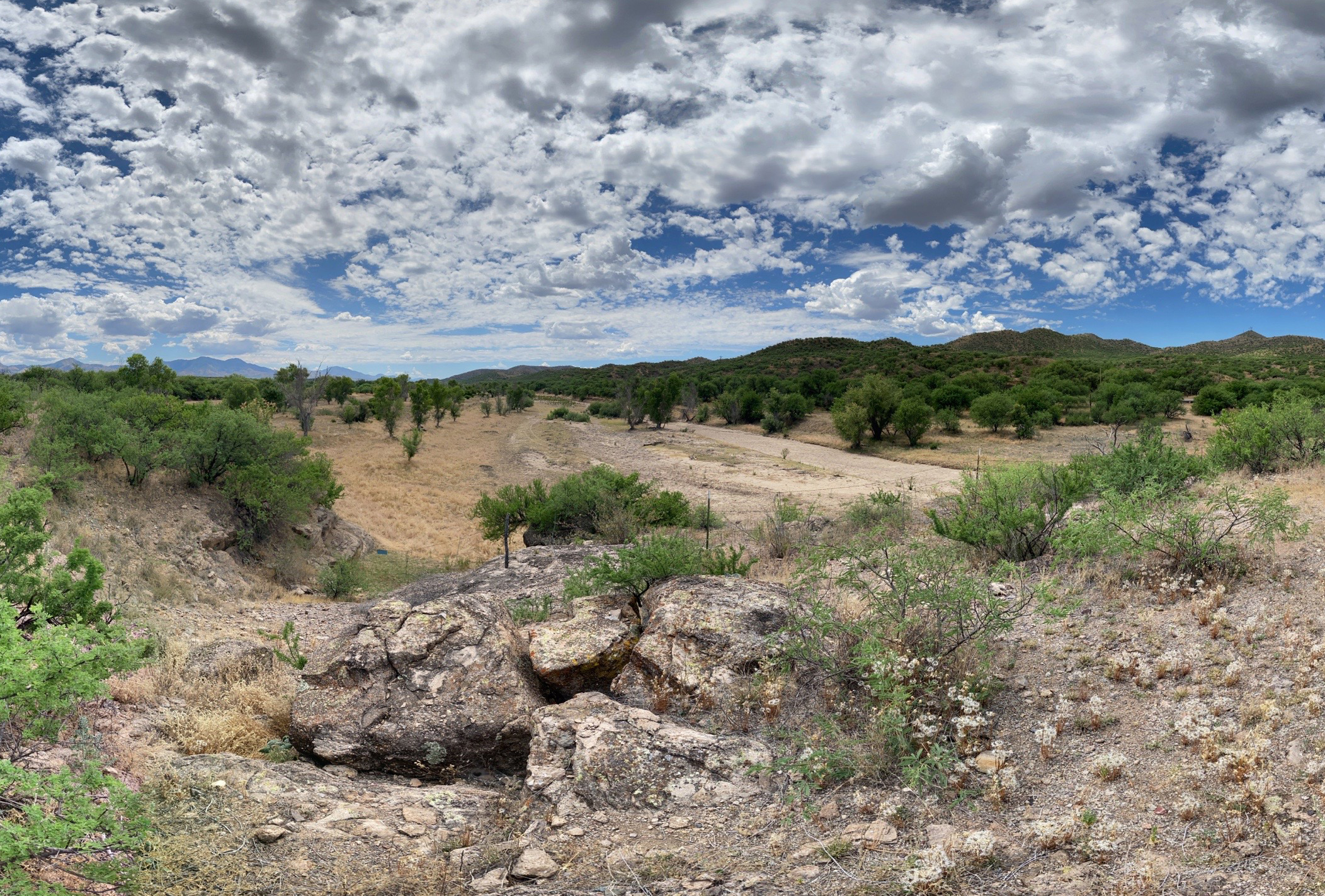
The site is sprawling, including large open landscapes of mesquite and creosote brush in desert upland. A large rock outcrop offers an overhead view of the river bed, usually dry and sandy, with gently sloping banks on either side. Across the road, mountains are visible. The mission site itself is a barely perceptible square outline of low, raised berms of earth, with the adobe remnants of the church oriented north-south along the western edge. The adobe walls run parallel to each other, about 5 feet high except where they slope down to the ground on the south side. On the northwest end, the adobe wall rises to about 10 feet in height. The walls are uneven, coated with a mud plaster on the top, with exposed adobe bricks along their faces.
The O'odham word for house is "ki" (kee). Melhok (pronounced moo' ro) is the word for the plant known in Spanish and English as "ocotillo." The particular structure that you see here is a modern construction of a traditional O'odham dwelling, made of mesquite timbers, ocotillo sticks, and mud.
In front of you is a rectangular, nearly square shaped building about 12 feet in width, 10 feet in depth and 6 feet tall. Made from daubed mud, the outside wall surface of the building is the brown-grey color of the surrounding earth, and is roughly textured. The roof is constructed of support beams made from mesquite branches about 5 inches in diameter. These can be seen protruding at the top of the mud walls at the roof line. The roof also contains sticks of ocotillo, a common desert shrub with long, straight, thorned branches about 1/2 inch to 1 inch thick and up to 12 feet long. The ocotillo sticks are laid side by side and sealed together by mud, forming the roof and creating an almost flat, somewhat wavy roof shape which hangs a few inches over the perimeter of the building on each side. There are no windows, but there is a doorless entrance about 2 feet wide and 5 feet high located slightly right of center as you look at the front of the building. An open-air, flat-roofed portico stands a few feet in front of the mud house. Its structure is comprised of mesquite branches overlaid with ocotillo branches. The ramada roof is supported by 9 rustic mesquite branches stripped of bark and about 3 to 5 inches in diameter. These are evenly spaced, creating a covered walkway leading to the entrance of the of the ki and providing shade to a broad area in front of it. On the ground below are four grinding stones. Inside the dwelling is a concrete floor with a thick layer of dirt over the top. It is dark except for the rectangle of light from the small entrance. The mesquite branches and ocotillo sticks that provide the building's structure are visible, and the mud walls appear similar to the outside walls.
The mission had a communal system of growing, collecting, and distributing food. The stairs led to a second story where additional food and animal fodder were stored. The food was kept in baskets and clay pots for later distribution.
The storeroom building is a roughly rectangular, roofless adobe structure located slightly northeast of the Franciscan church. Approaching the structure from the outside, it appears as a simple brown, plastered adobe structure with wavy, jagged walls of uneven heights. The front wall disappears to the right into a mound of grass-covered ground. Visible through the doorway is a steep plaster-coated staircase. Some light shines down into the open, roofless structure. As you enter the storeroom, the wide bank of 8 very steep stairs faces the doorway and rises all the way to the top of the wall. A nearby sign asks visitors to refrain from walking on the stairs. Attached to the stairs on both the left and right, sits a tall, rectangular, chest-high, plaster-covered adobe structure that appears much like an ancient counter or shelf. To the right, on the eastern side of the room, the wall is formed into a low adobe bench running the length of this side, with circular indentations on the top of the bench, many holding large, red clay pots. High above the pots near the top of this wall, a circular dark, wooden beam stretches the length of the wall resting on two square adobe pillars that are part of the wall structure. Perpendicular to this beam another beam emerges from the adobe wall stretching across the width of the structure. Another identical beam structure on the other side of the doorway is visible, although there are no pots on the other side of the room. High on the east and west walls, multiple holes are visible in a horizontal line, suggesting where other wooden beams may have previously pierced the adobe walls. On the north and south walls, the main notable features are another chest-high counter or shelf-like adobe square column which sits under a circular indentation or opening in the wall.
A right turn immediately upon entering the church will lead you into the room where the ceremony of baptism was performed. From birth and baptism through life and death, the imported Catholic religion became a part of the lives of community members. Here adobe walls, nine feet thick with an inner rock core, support the massive bell tower above you.
Upon entering the church, the baptistry is located to the right and is accessed by walking through a dark vaulted tunnel of earthen-colored adobe brick. Measuring about 150 square feet, it is a small roughly square-shaped room with grey, earthen adobe brick walls. Above is a domed roof made from adobe bricks. To the right of the entrance, an arched window opening at waist height reveals the 9-foot thick walls that create a tunnel of light extending from the outside into the dark space. A doorway with a staircase is visible on the left wall. After a few steps, it is blocked by a metal gate.
The courtyard garden at Tumacácori was built in 1939 as part of the visitor center's New Deal era construction. Its design aesthetic, like many of the adjacent visitor center architectural details, mirrors that of the missions in New Spain.
Upon entering the courtyard garden, visitors are reminded of a Spanish colonial courtyard garden refuge. Vine-covered garden walls formed by the surrounding buildings enclose the central space which is often full of color with the bright greens of the plants’ foliage and a variety of flower colors. In the center of the garden is a fountain pool with turquoise-colored plaster/cement interior bordered by an octagonal pool wall with a brick bench-top. The fountain is filled with water and features a cream-colored fountain-head scalloped basin held up by a graceful pedestal. Circling the central fountain and various planting beds are garden paths made of brick pavers laid in a herringbone design. One of these paths also leads to the restrooms. The garden plants exhibit a wide and beautiful diversity of form, shape and size, and include a number of trees that provide shade to visitors. The plants displayed include both some local desert species with characteristic spiny or succulent leaves, as well as European species. Plant markers note the genus, species and common names of plants. Low adobe-style benches on the north and south sides of the fountain offer multiple places to sit. Warm yellow painted arches of the main park building’s stuccoed walls are also visible.
The mission community included housing for the mission residents and the priest, workshops, class rooms, a cemetery, a mortuary chapel, an irrigation system, gardens, orchards, and grazing lands. In fact, a mission did not always have a church. Tumacácori was established as a mission in 1691, but it did not have a dedicated church building until 1756, over sixty years later.
Sitting in the middle of an open alcove corner room is a small-scale model of the mission grounds encased in a plexiglass display case measuring about 4 feet by 4 feet. The model provides an aerial view of the grounds as they may have appeared during mission times. Miniature figures portray the major elements of the Tumacácori mission: The Franciscan church flanked on the north by the cemetery, storeroom, and on the northeast by buried ruins of workshops in the courtyard arcade, and the south by the convento complex arcade area and courtyard walls. Further northeast of the church courtyard area, the model displays miniature renditions of the acequia or irrigation canals, and the orchard. This mission model display is the centerpiece of the room you are standing in and offers a small-scale view of what the grounds may once have looked like. This view contrasts with the scene of the actual Tumacácori church and grounds visible through large open, arched windows of this room. Today’s Tumacácori is now in various states of preservation, stabilization and ruin.
Standing here, perhaps you can visualize life at Mission San José de Tumacácori. To the left of the trail is a mound that runs from the visitor center museum to the front of the church. Beneath this mound are the foundations of the residents' adobe houses.
In front of you is a large, open field of sand, gravelly soil and sparse vegetation about 3 acres in size that is known as the community plaza. A concrete path divides the community plaza area and leads visitors to the church, the centerpiece of the Tumacácori grounds. On the left, this open space is bordered by a low berm of earth covering now buried ruins of adobe dwellings. On the right is a path leading to the cooking ramada and the melhok ki. The primary view from the community plaza is the towering and impressive church façade.
The Santa Cruz River has long been a highway of trade and travel. Prehistoric people followed the river to trade with neighbors. The O’odham farmed along the river, using the floodplain and low banks to grow crops. Later, missionaries and explorers would rely on these existing networks to colonize the area.
At this intersection, the Anza trail runs north and south. To the east, the trail continues to the river overlook. There is colorful wayside exhibit with information about the Anza expedition commemorated by the intersecting trail. This point marks the junction of trails – to the west, trails lead back to the mission grounds. To the east, the trail leads to the river. The Anza trail runs north and south. A nearby bench invites visitors to rest.
Probably the single most important commodity in the desert was, and is, water. Water for drinking, washing, bathing, and irrigating crops was taken out of the Santa Cruz River nearly a mile upstream to the south of where you are standing. It came to this point via an acequia, or irrigation ditch.
The visible remnant of the acequia or irrigation ditch appears as a roughly rectangular depression in the earth about 10 feet long, 4 feet wide and 2 feet deep. Looking down into the structure, the fired adobe brick walls appear like crumbling, grey, retaining walls that would have once held water in a rectangular pool. The east and west long sides of the rectangular acequia are made of about 6 courses of adobe brick rising at a 90 degree angle from the dusty, dirt floor. The shorter north and south ends are comprised of soil and slope up gradually to meet the surrounding surface of the ground. On the north end of the structure, the sloped opening to the surrounding surface of the ground is a narrow funnel created by a short, diagonally curved brick dam extending from the adjacent east side partially across the width of the structure, leaving a narrow, upwardly sloping, rocky soil-covered opening to the surrounding ground. Where the edge of the acequia meets the surrounding ground, a row of reddish brown bricks forms a flat surface flush with the ground and the wall of the structure. Some of these edging pavers are covered with a protective plaster coating. A faint remnant of the historic ditch’s patch remains visible on either side of the rectangular structure. A trail follows its route downstream.
This rich woodland plant community supports a tremendous biodiversity of insects, birds, and mammals. Today, the mesquite bosque of Tumacácori protects the threatened yellow-billed cuckoo and other rare species. It provided the O’odham, and later the Spanish, with wood, medicine, and food.
The mesquite bosque or forest that surrounds you in this area is dominated by the widespread mesquite tree, a widely branching tree with twisted limbs and dark shaggy bark. These trees, about 15-20 feet high form a canopy along the trail, and are seen everywhere in this landscape. Growing alongside the mesquite trees are also hackberry trees and elderberries. Beneath and around the mesquite trees are a variety of grasses and low-growing forbs, and a few types of thorned bushes.
Lime plaster was used to protect adobe buildings from moisture. Tons of raw material had to be brought to the mission for processing so that a coat of plaster, often more than two inches thick, could be applied to the walls.
The lime kiln is a circular, below-ground well-like structure about 6 feet in diameter. The walls of the lime kiln extend about 1 foot above the ground and are covered on the top and exterior by a brownish-cream colored plaster coating. The rounded flat surface of the wall is about a foot wide. As you look down into the underground interior of the lime kiln, the walls appear to be made of dried, brown, adobe brick with a layer of red colored bricks at the bottom about 5 feet down. The floor of lime kiln is sandy gravel. Back above ground, a hexagonal, brown, metal fence with horizonal rails surrounds the entire circular kiln structure protecting it from climbing or entry.
The bell tower was built in three stories: on the ground floor lies the baptistry, on the second level the preparation room for the choir, and on the third level the arches and bells. The scallop shell niches harken to Saint James, Santiago de Compostela, the patron saint of Spain, and indicate a baptistry below.
Rising up from the right side of the church is a red brick tower with a crumbling, deteriorated appearance. The top wall of the tower has a jagged and unfinished look, although the roman arch of the belfry remains. A metal bell hangs by a rope from a weather-worn beam under the arch of the open belfry. Open sky shows through as a background to the bell in the rectangular arched opening of the belfry. To each side of the central, open belfry opening is a rectangular statue niche with a cracked, beige plaster shell motif inlaid at the arched top of each niche. A number of small, square, evenly spaced holes are visible across the width of the bell tower. The red brick tower contrasts with the mostly plaster-covered exterior of the rest of the church below.
Two features come into view as you enter the cemetery. The first is the mortuary chapel, circular in design and about sixteen feet in diameter. The roof, possibly intended to be a dome, was never completed. Its walls have heard the echoes of many funeral Masses and rosaries. The Soto marker identifies several graves belonging to members of a family who lived at Tumacácori after the turn of the twentieth century.
An expansive square-shaped outdoor area surrounded by an adobe wall opens before you. About 75 feet in length on each side, this thick adobe wall encloses the large space and gives an appearance of a park-like area. About 8 feet tall and 2 feet thick, the cemetery walls have a smooth, brownish-beige plaster coating. The wall is a few feet higher on the northeast portion of the wall and it is also punctuated by visible bullet holes in this section. The top of the wall is covered by a protective layer of brick and plaster that overhangs the wall slightly. Spaced at about every twenty feet near the top of the wall are 14 hollowed, arched niches. In the west Cemetery wall, the eye is drawn to a brown, painted wooden door, covered by a triangular brick transom that leads to the church grounds on the northwest side of the church. Mountains rise in the distance behind the west wall. The center of the cemetery is mostly an open space with gravelly soil and very sparse, grassy vegetation. Three gracefully branched mesquite trees sit in the central part of the space and one occupies the northeast corner providing some shade in these areas. Wooden crosses marking graves in the northern part of cemetery provide a background to a larger, beige plastered grave monument shaped like a small coffin, topped on one end by a painted wrought iron cross decorated with a metal monument name plate and flowers. The name plate displays the name Juanita Alegria, born in 1915 and laid to rest in 1916. The mortuary chapel is a roofless, circular building about 16 feet in diameter and 15 feet high standing near the entrance to the Cemetery. The outer walls of the building appear to have small, decorative pieces of fired red brick stuck into the adobe walls. The upper portion of the wall has a plaster covering over this pebbled adobe. About a foot below the top of the building, a row of horizontally laid, fired and burnished red bricks create a decorative line around the building, and above this row of bricks at the top of the building is a cornice made of curved, fired and burnished bricks laid vertically in a decorative pattern. Outside of the south side of the mortuary wall, a colonial-style wooden cross with the name Soto etched on it sits atop one end of a grave-shaped mound of stones. Around the curve of the building to the west, the mortuary building is open to visitors via an arched doorway about 4 feet wide facing the western cemetery gate. Entering through this doorway reveals the 3 foot thickness of the mortuary walls. Inside, the circular, roofless view above opens to the sky and is framed by the decorative brick cornice design at the top of the building. Below, gravelly soil over concrete comprises the floor. The mortuary walls, like other adobe brick structures at Tumacácori, reveal a view of both grey adobe bricks, and a patchy combination of various brownish-colored plaster coatings, many etched with cracks. Near the top of the wall, about 5 feet from each side of the door, are circular openings to the outside that are about 4 inches in diameter and give the appearance of small tunnels in the thick walls.
The community used this small church under the guidance of Jesuit priests for ten years, until the Jesuits were expelled in July 1767. Father Custodio Ximeno was the last Jesuit to serve at Guevavi and Tumacácori. He performed his last service here on June 14, 1767, just six weeks before his arrest at Guevavi and his subsequent exile.
Rising from an open area east of the church and north of the convento fragment this structure appears as a low, rounded, smooth, plaster-covered wall about 2 feet thick and about 1 foot tall. It appears as a rectangular, plastered, stone outline about 50 feet long and about 15 feet wide protruding from the otherwise flat soil and sparse vegetation of the park grounds. There is an opening in the eastern width of the foundation outline about 5 feet wide, indicating where the main doorway once was. The sight of the Jesuit church footprint from the eastern side is dominated by the background view of the imposing and contrastingly preserved structure of the more recent Franciscan church. With its bell tower on the left and sacristy dome on the right, it overshadows the simple, low rectangular outline in front of you.
The convento was the operational part of the mission. It functioned as a shared, community workspace and governmental center. It would have been alive with the sounds of people talking, working, and moving about. The rooms aligned in a U-shape around a central courtyard.
The convento complex refers to the open square shaped building and courtyard area to the east of the Franciscan church and storeroom. Now, with the convento building ruins mostly underground, it appears as an open space about half the size of a football field. In the central open area, the most notable feature is the low-to-the-ground plaster-covered remains of the foundation of the older Jesuit church. On the north, a low berm of sparsely vegetated earth runs east-west along the length of the area marking the covered ruins of the row of rooms that formed the north wall of the courtyard. To the south is the still-standing remnant ruins of part of southern courtyard row of rooms, now known as the convento fragment, or convento ruins.
Music played an important role in mission life. Tumacácori likely supported anywhere from eight to ten choir members, both men and women, at a given time. There were also musicians who played instruments such as oboe, flute, and zither (guitar), adding flourish to the sound of the Masses and other religious ceremonies held here.
While standing in the nave facing toward the main church door, the choir loft ruins are visible above the church entrance on the second floor. All that now remains of the choir loft is a small entrance high on the left side as you face the church main door, and two weathered pillars that supported it. Church walls framing this area are made of grey, adobe brick with a weather-stained cream-colored plaster coating that remains in large patches and is also missing from large patches. A row of narrow, fired, dark red bricks lines the top of the walls and connects them to the wooden-beamed ceiling of the church. A window opening to the outside is visible and brings light into the choir loft and nave.
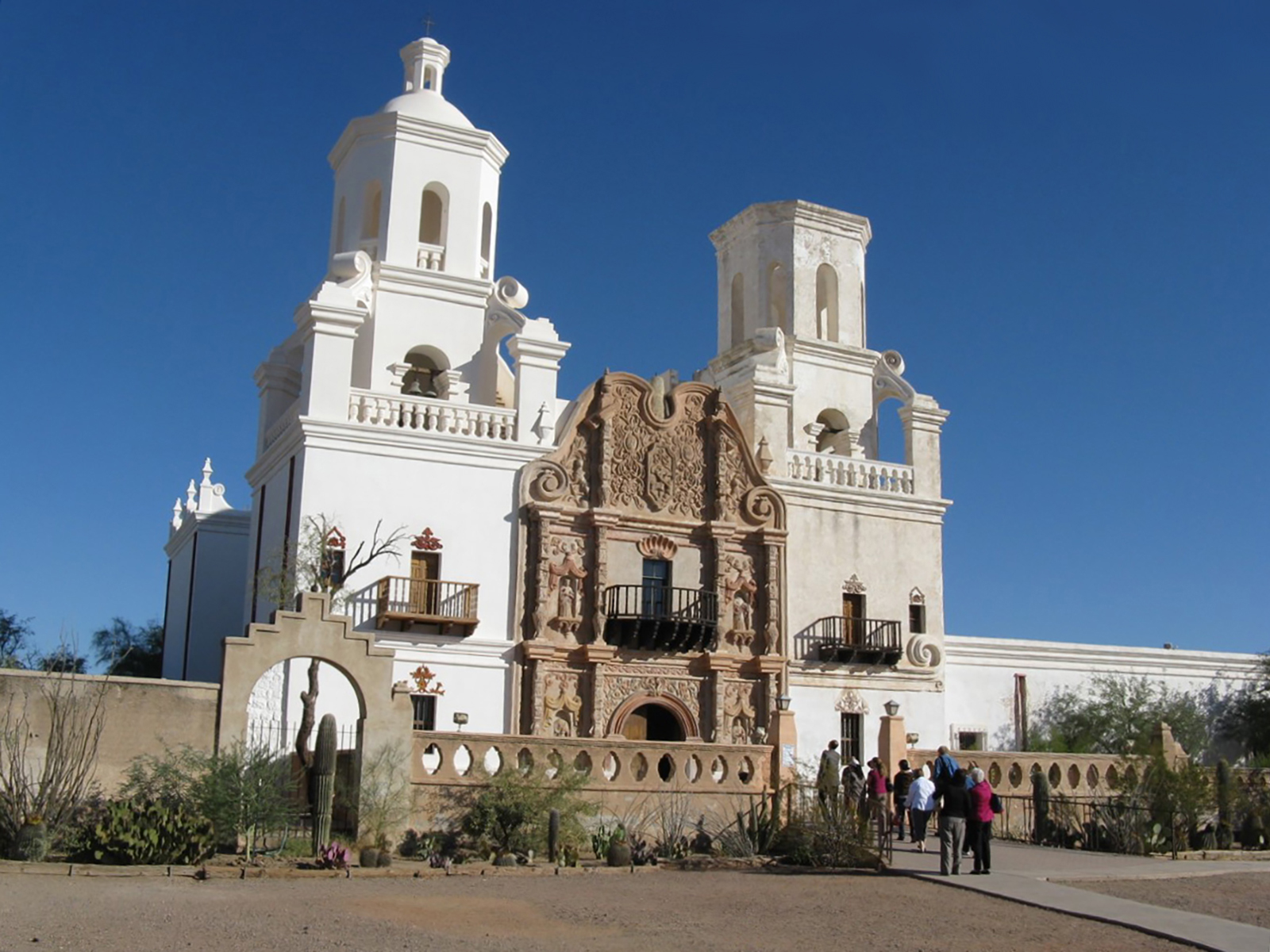
The façade of the church was painted with bright colors. Today, in the doorway and under the cornice below the window, some of the original color is still visible. The half circle of the espadaña, or pediment, is a reconstruction dating to 1921.
Built from earthen-colored adobe bricks, the church facade reflects the preserved yet not restored look of a nineteenth century Spanish colonial church. The facade shows both original adobe brick, as well as some of the smooth, beige, plaster coating. On the left, an arched espadaña or pediment made of bricks frames a large, darkened doorway with arched wooden doors. The front door spans about one eighth of the length of the structure. The large doorway is symmetrically framed on each side by a pair of columns which together hold up a cornice supporting two pairs of additional pillars above which frame the large second-story window. These pillars are slightly closer together than those below. All pillars have Egyptian style capitals at their tops, and between each pair of pillars is an empty niche holding a round, pendant-shaped statue pedestal and framed above by a pointed, Moorish-style arch. Above the second floor, on the left side of the church, the top part of the facade rises to form a semicircular shape which holds atop its center, a small, round, plaster-covered finial anchoring a simple wooden cross. On the right side of the building, there is large window on the first floor to the right of the doorway. Above it, at various places in the otherwise plain facade, there are a few round and square holes in the building, the diameter of wooden beams, which were once used to hold scaffolding. Above these, a rectangular, brick bell tower, the tallest part of the church, rises higher than the left side of the church facade. Its central belfry opening is framed above by an arch and bordered on the left and right by oval-shaped niches.
The standing ruin of a fragment of the convento includes the rooms in which the priest is likely to have lived. These rooms have seen much use, both during the mission era and afterward. After the mission residents left, it was used as a house by various people and was even used as a school in the 1930's during the administration of the first resident superintendent at Tumacácori National Monument.
This is a rectangular, walled, roofless ruin of this structure made of adobe brick and covered with a smooth brown plaster. The outside corners of the convento fragment are rounded, and on the western side of the structure there is a wooden-framed doorway extending about 1 foot above the surrounding plaster walls. Entrance via this doorway is blocked by a railing; however, one of the interior rooms is visible from the outside of this doorway and appears empty with floor of sandy, gravel ground sparsely covered with vegetation. Veined with cracks, the roofless adobe walls are quite uneven at the top and covered by a flat row of thin, red paving-type bricks. The structure's southern facing wall is held in place by four bulky, tapezoidal-shaped buttresses also covered with light brown adobe plaster. There is a horizontally rectangular, weathered wood-framed, double window opening to the right side of the four buttresses, and a single window opening to the left of the buttresses. In the center two buttresses is a worn, gray wooden doorway. Viewed from the inside, the structure is divided into two rectangular rooms separated by a worn wooden door frame. In the room in front of and to the east of the entrance door, one of the primary visible features is the rust-colored, dusty remains of a herringbone brick floor. The other notable feature is the rounded-cornered, traditional adobe fireplace with a conical chimney built into the corner of the room. A horizontally rectangular, double window opening made of weather-worn wood is located on the north side of the room near the fireplace, and it offers a view of the Franciscan church to the northwest, and the spacious church grounds to the north marked with the low-walled outline of the remains of the Jesuit church. The view is framed distantly to the north by a low berm of grass-covered earth that contains the buried remains of the north side of the convento structure.
The mission complex included a walled garden and orchard. The treelines in front of you and to your right grow along the stone foundations of two of the adobe walls which originally surrounded and protected this area. Within this 4.6 acre enclosure, the community grew vegetables and fruit trees. The orchard would have contained favorite trees brought to the mission from Europe such as peach, pomegranate, quince, and fig.
Throughout the orchard, grass and other short vegetation covers the ground and is punctuated with a variety of about 100 fruit trees planted equidistantly about 12 feet away from each other. Wide, open rows invite visitors to explore the space, and benches are located on the eastern side of the orchard providing a spot to rest. Some trees, such as the peaches, are widely branched and about 10-15 feet tall, while others like the pomegranate and fig are more compact and about 4-8 feet tall. Also present are plum trees, standing about 10-12 feet tall and displaying a narrower growth habit along with their characteristic purple/black bark. Each tree is circled at its base by raised, black edging that holds brown, pecan shell mulch and a few small white irrigation spouts, giving the orchard a neat and well-tended appearance. Also staked into the ground at the base of each tree is a metal marker noting the tree species.
The O'odham word for house is "ki" (kee). Melhok (pronounced moo' ro) is the word for the plant known in Spanish and English as "ocotillo." The particular structure that you see here is a modern construction of a traditional O'odham dwelling, made of mesquite timbers, ocotillo sticks, and mud.
In front of you is a rectangular, nearly square shaped building about 12 feet in width, 10 feet in depth and 6 feet tall. Made from daubed mud, the outside wall surface of the building is the brown-grey color of the surrounding earth, and is roughly textured. The roof is constructed of support beams made from mesquite branches about 5 inches in diameter. These can be seen protruding at the top of the mud walls at the roof line. The roof also contains sticks of ocotillo, a common desert shrub with long, straight, thorned branches about 1/2 inch to 1 inch thick and up to 12 feet long. The ocotillo sticks are laid side by side and sealed together by mud, forming the roof and creating an almost flat, somewhat wavy roof shape which hangs a few inches over the perimeter of the building on each side. There are no windows, but there is a doorless entrance about 2 feet wide and 5 feet high located slightly right of center as you look at the front of the building. An open-air, flat-roofed portico stands a few feet in front of the mud house. Its structure is comprised of mesquite branches overlaid with ocotillo branches. The ramada roof is supported by 9 rustic mesquite branches stripped of bark and about 3 to 5 inches in diameter. These are evenly spaced, creating a covered walkway leading to the entrance of the of the ki and providing shade to a broad area in front of it. On the ground below are four grinding stones. Inside the dwelling is a concrete floor with a thick layer of dirt over the top. It is dark except for the rectangle of light from the small entrance. The mesquite branches and ocotillo sticks that provide the building's structure are visible, and the mud walls appear similar to the outside walls.
Step through the arched entryway and into the remains of an impressive nave, the central hall of the church. In this room, indigenous people and Spanish settlers prayed and celebrated the Mass each day. There were no pews. People knelt or stood during services. Along the walls are four side altars where devotional candles might be placed. In the walls above are niches where ornate statues of saints once stood.
As you walk into the main church entrance down the entrance ramp, you enter the Nave. This is the long, narrow body, or main corridor of the church measuring about 100 feet in length and 20 feet in width. A narrow, arched adobe brick doorway rises to the right, leading through a vaulted tunnel to the baptistry. Near the arched main entrance to the church, there are two columns, one on each side of the nave, that rise from the floor to about 10 feet in height, now diminished to adobe ruin. Two more columns, closer to the front of the church, can be seen on each side of the Nave rising to the ceiling from a tapered decorative base about 10 feet above the floor. Each column holds a tall, narrow niche with a corbel or statuary shelf, which is now empty. The floor of the nave is made of burnished, dark red bricks. Two side altars line each wall of the nave along the length of the room. Each of these altars is now a rectangular mound of adobe brick ruins, rising from the floor to varying heights between a few inches off the floor to about 4 feet, and protected from visitors by stanchions made of wooden posts laced with thick rope. Tall, narrow arched statue niches are recessed into the walls above the altars. A few colonial style, unadorned, dark wooden benches line the walls between the altars. The walls are made of exposed, time-worn adobe bricks that are grey-brown in color. In some places along the walls, especially on the upper portions, a whitish, age-stained plaster coating covers the aged bricks in large irregular shapes, having fallen off or been damaged over the course of centuries. On both sides of the nave, there are many uneven holes in the walls, some fist-sized and some much larger, resulting from weathering, vandals, and treasure hunters from previous centuries. Light enters in a stream from a window above the main entrance door to the church, and from a window on the eastern wall about 30 feet in front of the entrance. The long, narrow space of the nave leads the visitor's sight forward to the south end of the church, the sanctuary, which rises at the top of 5 adobe brick stairs at the front of church. The stairs are covered by an arched entrance and flanked on the right side of the nave by the simple reconstructed base of the pulpit, protruding from the wall as an inverted triangular structure about 4 feet off the floor.
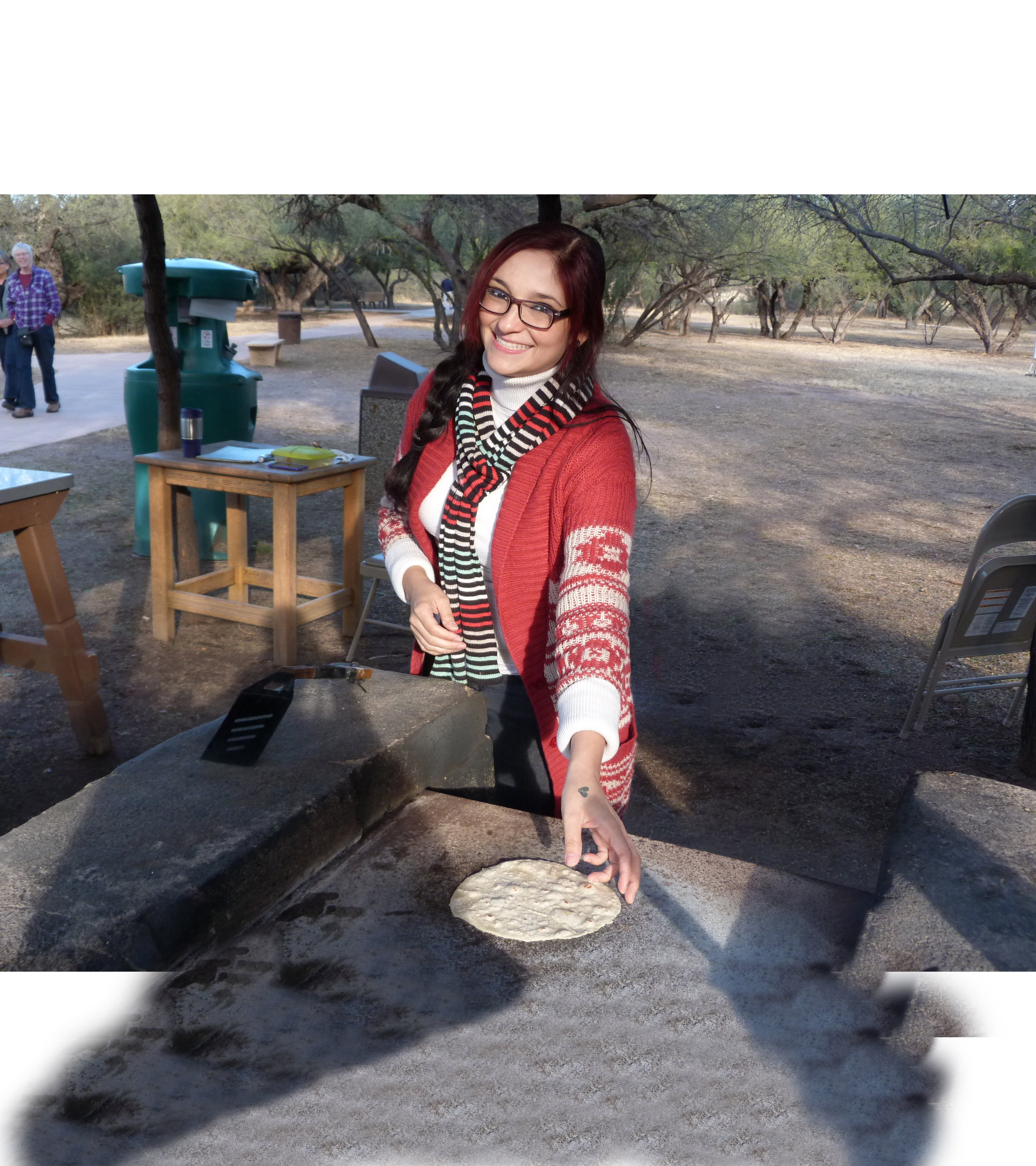
After hundreds of years of mixing, marrying, creating new families, and blending traditions, a new people emerged: the mestizaje of Mexico. Flavors like chiles, carne asada, and tortillas reflect this mixing of origins. Sharing traditional foods—made fresh in kitchens such as this one—connects us to each other and to our shared heritage.
The ramada is a square-shaped, open-air pergola or roofed shelter with no walls. It measures about 12 feet by 12 feet in size, and sits in the open community plaza area northeast of the visitor center building and southeast of the church. The roof is made of ocotillo covered with a thin layer of board wood and supported by a metal, mesh roof frame. The roof is held up by posts of thick tree branches. The roof provides plenty of shade beneath the ramada. The floor is the same as the surrounding open community plaza, mostly dirt with scattered low-growing vegetation. This rustic structure provides shelter to a few rustic, wooden tables with metallic tops that form a serving counter on one side, and on the other side a hand-made cement enclosure with a comal (flat surface for cooking tortillas). The rustic, outdoor oven appears to have been used recently and is stained with black soot. Burned wood charcoal is present under the comal. Next to the oven sits a stack of cut wood and sticks, and inside the cooking ramada sits a chair.
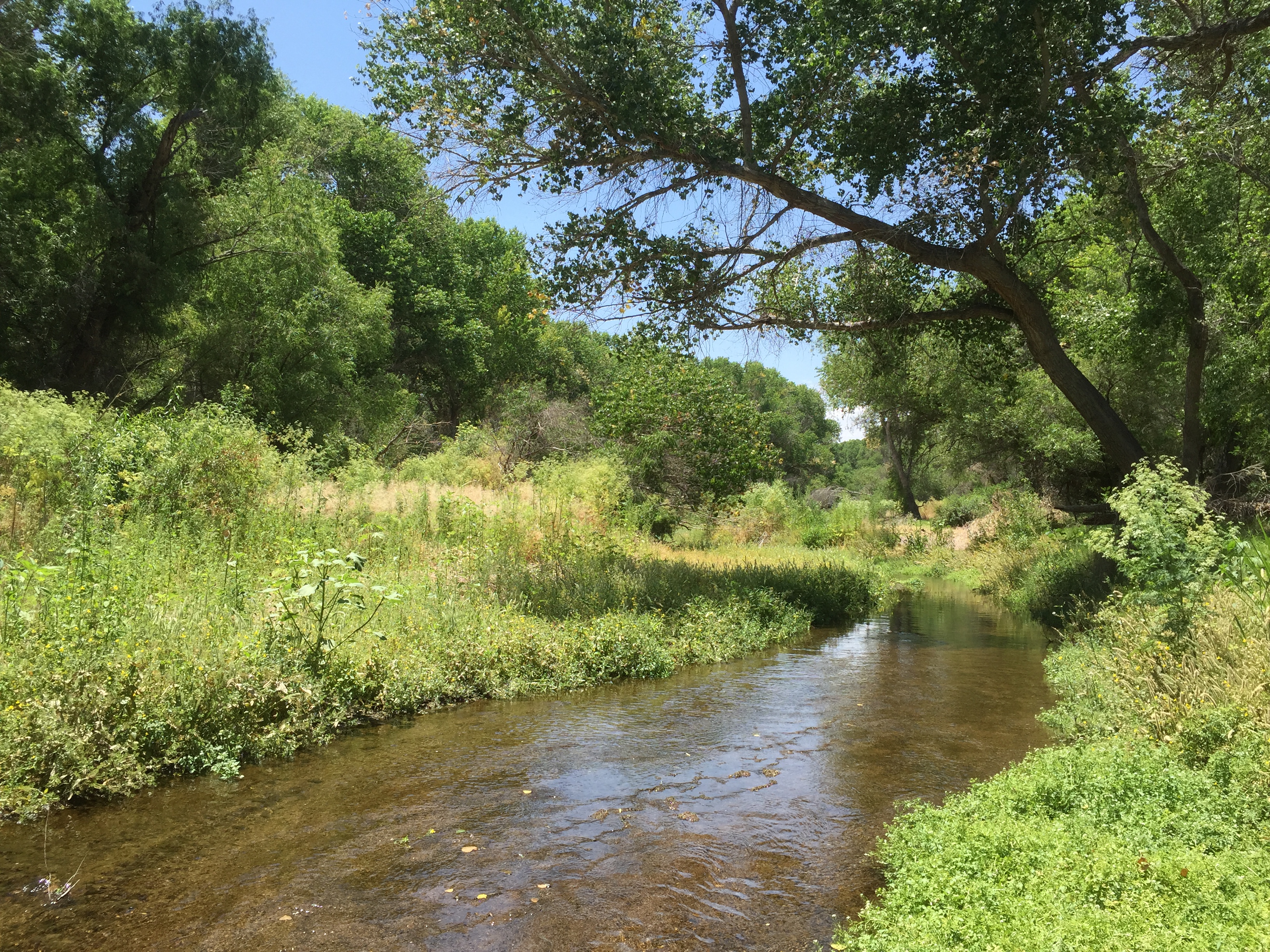
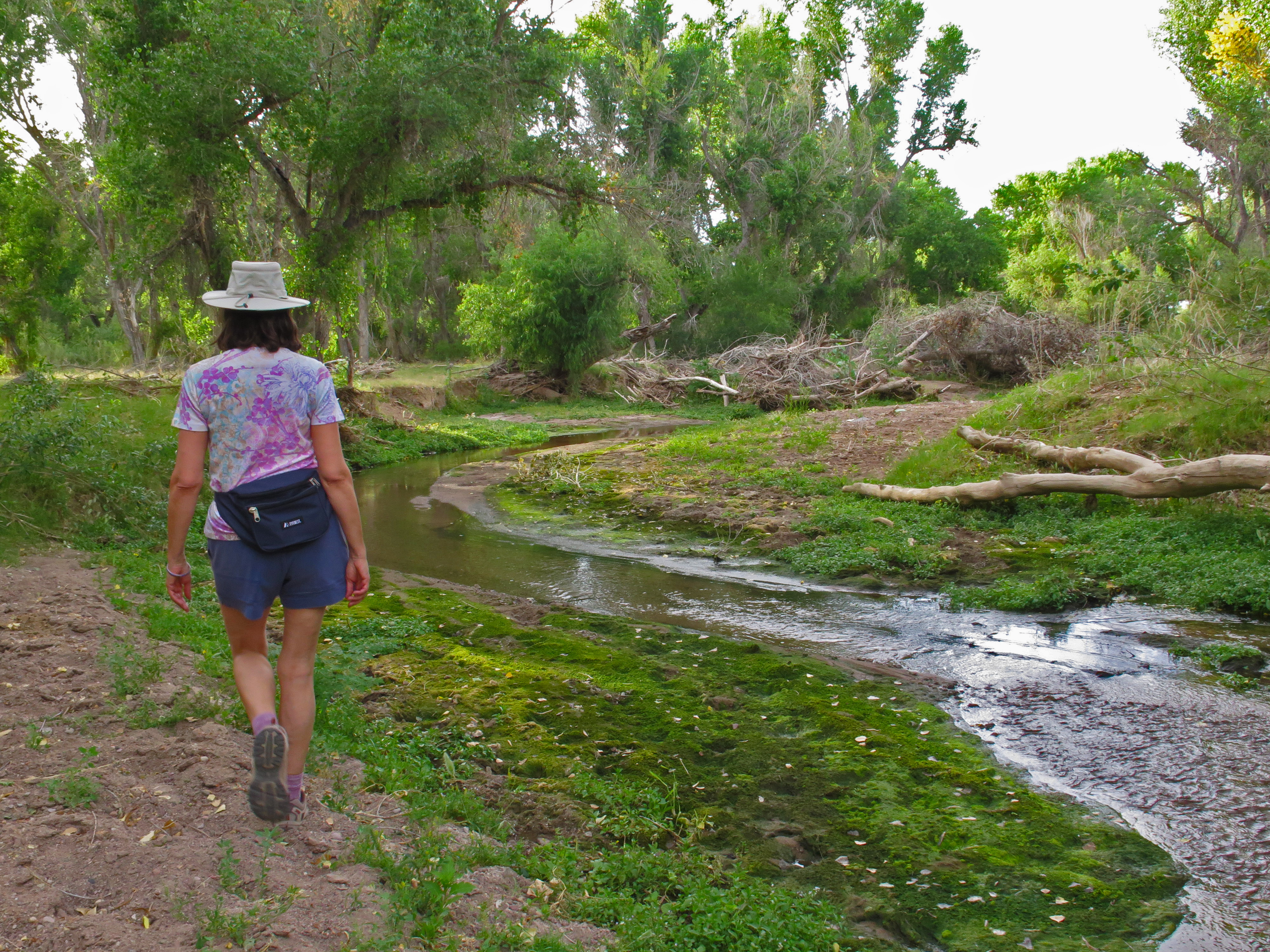
The Santa Cruz River is an international waterway. It begins in the San Rafael Valley, flows southward into Mexico, then makes a U-turn back into the United States. Here, it flows from south to north, eventually joining the Gila River. The river creates essential habitat and a wildlife corridor for threatened and endangered species.
The Santa Cruz river runs from south to north in a winding channel about 30 feet wide. The flow passes very slowly and the water is shallow. The river banks are eroded and appear as if the water flow increases and decreases frequently. Lining the banks on both sides of the river are towering cottonwood trees, hundreds of feet tall, creating a tunnel of tree canopy above the river. On the river banks, branches, leaves and other debris are scattered in the understory along with some grasses and other moisture-loving vegetation.
Priests kept the clothing and articles used in the performance of their duties here. In the sacristy they documented and stored the records of important events, signing their names as witness to marriages, births, and deaths.
An arched doorway on the east side of the sanctuary opens to a ramp leading down to the sacristy. This is a dark room about 15 by 15 feet square. The room has a high, barrel-vaulted ceiling and a small doorway leading to the outside on the east side of the room. An arched window opening to the north also lets light into dark space. Four steps with deep treads made of fired brick lead from the Sacristy floor to a gated entranced to the pulpit. The sacristy floors are the same dark red, polished bricks that are present in the rest of the church. The walls are made of adobe bricks and they exhibit similar deterioration as those in other areas of the church, with patches of once white, now weathered and stained plaster interspersed with unprotected grey adobe brick. The vaulted ceiling appears supported on its east-west axis by an arched beam, covered in plaster, now faded and grey. Smudged with charcoal black and grey soot, the ceiling shows the stain from many campfires built in post mission times by soldiers, travelers and others seeking shelter here. Traces of some of these visitors are seen in the signatures, dates and other graffiti etched into the brick and plaster in numerous places in the sacristy.
Ascending the steps leading up out of the nave, one enters the sanctuary, still adorned with remnants of its original paints, picture frames, and extensive stenciling. Here the priest, dressed in his bright-colored vestments, celebrated the Mass.
Stepping up the stairs through the archway to the sacristy, the altar rises on the back wall in the center of the burnished red brick floor. The altar is a simple, rectangular adobe brick structure about 5 feet wide, 3 feet high and 3 feet deep. The high domed ceiling rises approximately 40 feet above the floor. The ceiling plaster color is varying shades of white, cream and grey with remnants of black stenciling. The walls are made of adobe brick which are greatly deteriorated with dozens of holes of varying sizes. In scattered areas, weathered plaster covers the adobe brick walls in large patches. One of the most captivating visual features of the sanctuary is the faded, decorative painting that can be dimly seen on each side of the altar. The decorative motif shows red painted draperies drawn back on each side of a central dome. On the wall behind the altar is a black painting of rectangular blocks. Faded floral garlands are also stenciled around the upper walls of the sanctuary above a row of painted brown-red picture frames. On opposite sides of the arched entry are faded paintings representing the holy communion – a chalice with grapes and a sheaf of wheat. Still visible in many places just below the faded orange colored circular cornice or bottom "edge" of the dome is a repeated pattern of small black squares, painted to appear as a "trompe l'oeil, or "optical illusion" architectural feature appearing as square stones holding up the cornice.
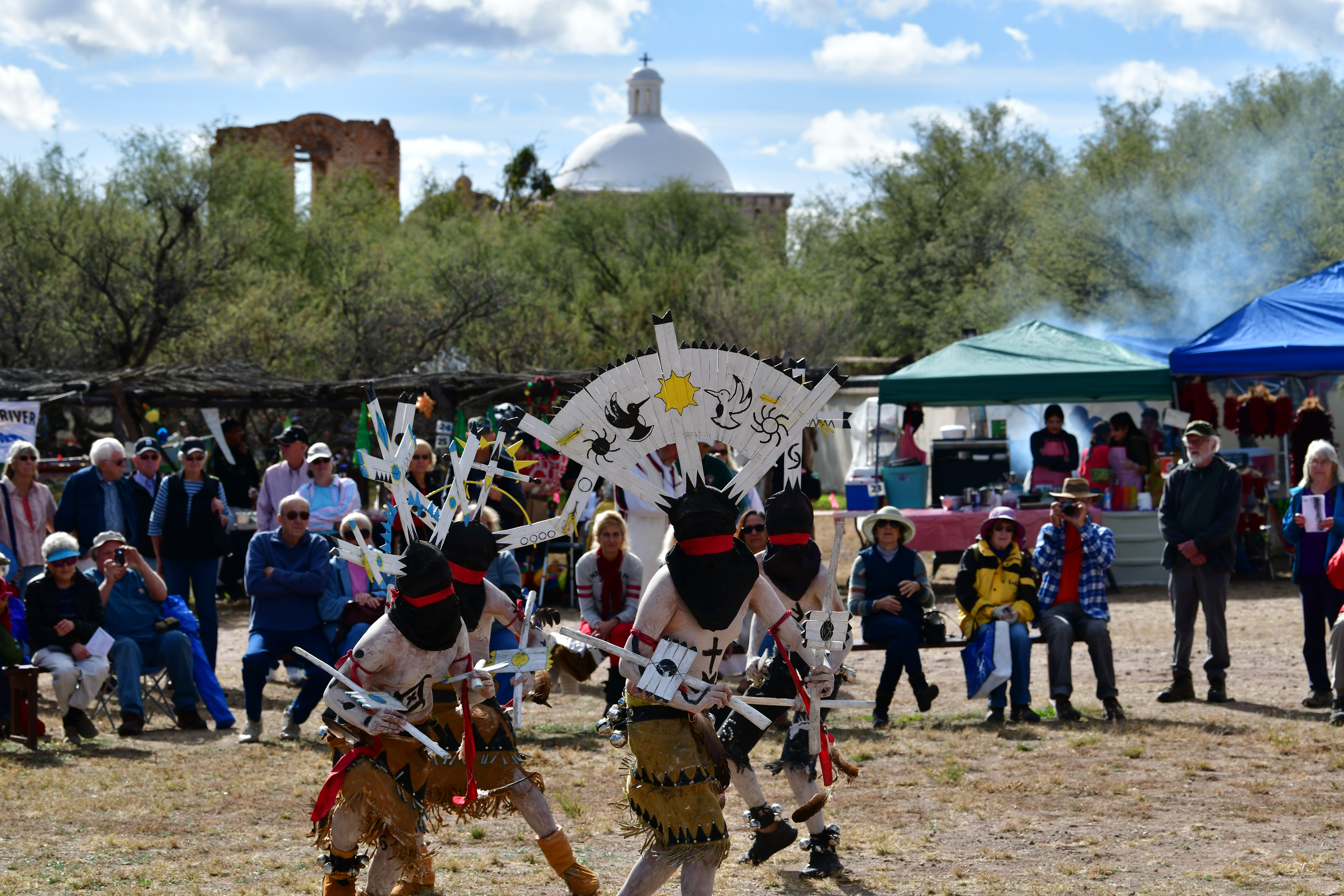
Each year, the Tumacácori Fiesta brings together people from all the cultures of the Santa Cruz Valley for two days of celebration. Each culture traditional to Tumacácori is represented in music and dance.
The fiesta grounds are a large, open field to the north of the lime kiln. This open area, about the size of a football field looks like an empty fairground area, with a centrally placed cement pad or stage, and a number of rustic ramada or hand-built pergola type structures scattered around the outside edges of the area. A few cement benches are on the south side of the grounds. About 30 small brown, painted wooden structures in the shape of an inverted U stick out of the ground on the south side of the grounds at intervals of about 8 feet. Some picnic tables are also present. The grounds are bordered on the north and east by a row of tall bushes and trees, and to the west by a metal gate and a parking lot on the frontage road. Paths lead east to the mission grounds and Anza Trail, and south to the lime kiln and mission grounds.
Directly in front of the most important, most symbolic, and most decorated structure of the mission are three features whose purpose remains a mystery.
Facing the church façade, 3 square or rectangular-shaped pits sit in front of the church to the right of the door. The first of these pits is square, about 5 feet in width and length, extending about 1 foot above ground and about 3 feet below ground. It is made of red brick, but almost completely covered by a beige plaster coating inside and out. Looking down into the vat, the bottom is plaster covered, though chipped and cracked in places. The low above-ground wall is about 1 foot high. Sitting adjacent to this vat, the middle of the 3 vats is a slightly larger rectangular shape constructed of layered red brick with some plaster coating also visible inside. The third vat is the smallest and most shallow, barely rising above the ground with red brick appearing only one layer high above ground, and only about a foot deep. The bottom of this shallow pit is covered with wide, red paving bricks. To the right of the 3 vats, a ditch runs eastward underneath the adjacent walkway. These pits are a visible aspect of the church façade area; however, little about their physical appearance gives any clue to their purpose.
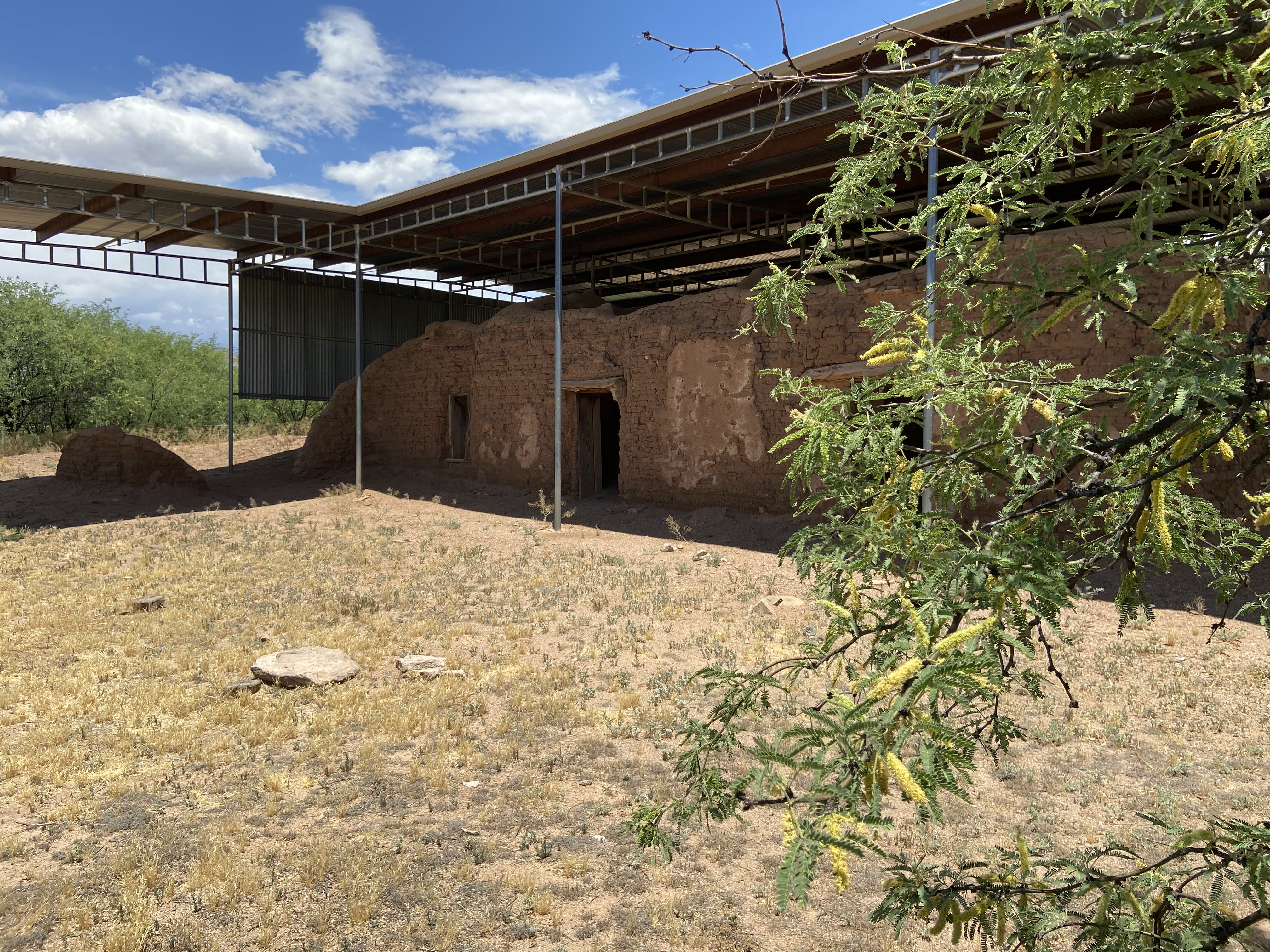
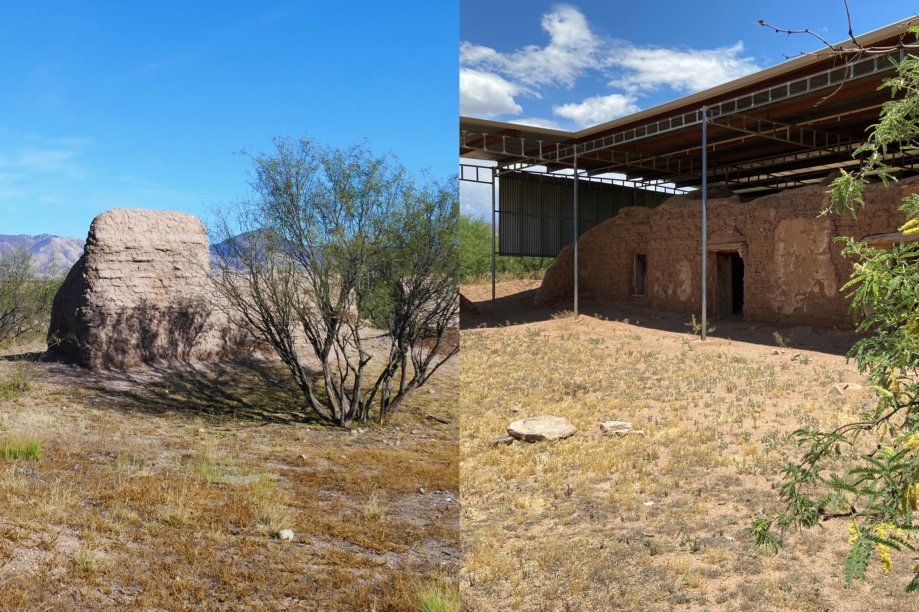
Only accessible during guided tours, the Calabazas mission site offers an excellent perspective on the adaptive re-use of mission-era buildings through the Civil War period and beyond.
A large metal roof shelters the adobe remnants of a church. At the north side, the roof extends in a leg to the east and then down to create a corrugated metal wall. Remaining exterior adobe walls extend in a north-south orientation over about 30 feet. Some dividing walls still exist inside the space, as well as doorways and window openings. At the south east corner of the fenced area, a remnant structure built from stone and mortar still stands.
The Santa Cruz River is an international waterway. It begins in the San Rafael Valley, flows southward into Mexico, then makes a U-turn back into the United States. Here, it flows from south to north, eventually joining the Gila River. The river creates essential habitat and a wildlife corridor for threatened and endangered species.
The Santa Cruz river runs from south to north in a winding channel about 30 feet wide. The flow passes very slowly and the water is shallow. The river banks are eroded and appear as if the water flow increases and decreases frequently. Lining the banks on both sides of the river are towering cottonwood trees, hundreds of feet tall, creating a tunnel of tree canopy above the river. On the river banks, branches, leaves and other debris are scattered in the understory along with some grasses and other moisture-loving vegetation.
Santa Cruz Valley National Heritage Area celebrates the region’s natural resources, rich history, and heritage shaped by generations of Native American, Spanish, and Mexican cultures.
The landscape for this National Heritage Area covers 3,300 square miles consisting of urban, suburban, and rural areas settled within the alternating mountain ranges, valleys, plateaus, and expansive deserts. Elevation can reach over 9,000 ft in some areas. Santa Cruz Valley is an arid desert climate but also includes many rivers and ephemeral lakes.
Probably the single most important commodity in the desert was, and is, water. Water for drinking, washing, bathing, and irrigating crops was taken out of the Santa Cruz River nearly a mile upstream to the south of where you are standing. It came to this point via an acequia, or irrigation ditch.
The visible remnant of the acequia or irrigation ditch appears as a roughly rectangular depression in the earth about 10 feet long, 4 feet wide and 2 feet deep. Looking down into the structure, the fired adobe brick walls appear like crumbling, grey, retaining walls that would have once held water in a rectangular pool. The east and west long sides of the rectangular acequia are made of about 6 courses of adobe brick rising at a 90 degree angle from the dusty, dirt floor. The shorter north and south ends are comprised of soil and slope up gradually to meet the surrounding surface of the ground. On the north end of the structure, the sloped opening to the surrounding surface of the ground is a narrow funnel created by a short, diagonally curved brick dam extending from the adjacent east side partially across the width of the structure, leaving a narrow, upwardly sloping, rocky soil-covered opening to the surrounding ground. Where the edge of the acequia meets the surrounding ground, a row of reddish brown bricks forms a flat surface flush with the ground and the wall of the structure. Some of these edging pavers are covered with a protective plaster coating. A faint remnant of the historic ditch’s patch remains visible on either side of the rectangular structure. A trail follows its route downstream.
The Santa Cruz River has long been a highway of trade and travel. Prehistoric people followed the river to trade with neighbors. The O’odham farmed along the river, using the floodplain and low banks to grow crops. Later, missionaries and explorers would rely on these existing networks to colonize the area.
At this intersection, the Anza trail runs north and south. To the east, the trail continues to the river overlook. There is colorful wayside exhibit with information about the Anza expedition commemorated by the intersecting trail. This point marks the junction of trails – to the west, trails lead back to the mission grounds. To the east, the trail leads to the river. The Anza trail runs north and south. A nearby bench invites visitors to rest.
A right turn immediately upon entering the church will lead you into the room where the ceremony of baptism was performed. From birth and baptism through life and death, the imported Catholic religion became a part of the lives of community members. Here adobe walls, nine feet thick with an inner rock core, support the massive bell tower above you.
Upon entering the church, the baptistry is located to the right and is accessed by walking through a dark vaulted tunnel of earthen-colored adobe brick. Measuring about 150 square feet, it is a small roughly square-shaped room with grey, earthen adobe brick walls. Above is a domed roof made from adobe bricks. To the right of the entrance, an arched window opening at waist height reveals the 9-foot thick walls that create a tunnel of light extending from the outside into the dark space. A doorway with a staircase is visible on the left wall. After a few steps, it is blocked by a metal gate.
The bell tower was built in three stories: on the ground floor lies the baptistry, on the second level the preparation room for the choir, and on the third level the arches and bells. The scallop shell niches harken to Saint James, Santiago de Compostela, the patron saint of Spain, and indicate a baptistry below.
Rising up from the right side of the church is a red brick tower with a crumbling, deteriorated appearance. The top wall of the tower has a jagged and unfinished look, although the roman arch of the belfry remains. A metal bell hangs by a rope from a weather-worn beam under the arch of the open belfry. Open sky shows through as a background to the bell in the rectangular arched opening of the belfry. To each side of the central, open belfry opening is a rectangular statue niche with a cracked, beige plaster shell motif inlaid at the arched top of each niche. A number of small, square, evenly spaced holes are visible across the width of the bell tower. The red brick tower contrasts with the mostly plaster-covered exterior of the rest of the church below.
Two features come into view as you enter the cemetery. The first is the mortuary chapel, circular in design and about sixteen feet in diameter. The roof, possibly intended to be a dome, was never completed. Its walls have heard the echoes of many funeral Masses and rosaries. The Soto marker identifies several graves belonging to members of a family who lived at Tumacácori after the turn of the twentieth century.
An expansive square-shaped outdoor area surrounded by an adobe wall opens before you. About 75 feet in length on each side, this thick adobe wall encloses the large space and gives an appearance of a park-like area. About 8 feet tall and 2 feet thick, the cemetery walls have a smooth, brownish-beige plaster coating. The wall is a few feet higher on the northeast portion of the wall and it is also punctuated by visible bullet holes in this section. The top of the wall is covered by a protective layer of brick and plaster that overhangs the wall slightly. Spaced at about every twenty feet near the top of the wall are 14 hollowed, arched niches. In the west Cemetery wall, the eye is drawn to a brown, painted wooden door, covered by a triangular brick transom that leads to the church grounds on the northwest side of the church. Mountains rise in the distance behind the west wall. The center of the cemetery is mostly an open space with gravelly soil and very sparse, grassy vegetation. Three gracefully branched mesquite trees sit in the central part of the space and one occupies the northeast corner providing some shade in these areas. Wooden crosses marking graves in the northern part of cemetery provide a background to a larger, beige plastered grave monument shaped like a small coffin, topped on one end by a painted wrought iron cross decorated with a metal monument name plate and flowers. The name plate displays the name Juanita Alegria, born in 1915 and laid to rest in 1916. The mortuary chapel is a roofless, circular building about 16 feet in diameter and 15 feet high standing near the entrance to the Cemetery. The outer walls of the building appear to have small, decorative pieces of fired red brick stuck into the adobe walls. The upper portion of the wall has a plaster covering over this pebbled adobe. About a foot below the top of the building, a row of horizontally laid, fired and burnished red bricks create a decorative line around the building, and above this row of bricks at the top of the building is a cornice made of curved, fired and burnished bricks laid vertically in a decorative pattern. Outside of the south side of the mortuary wall, a colonial-style wooden cross with the name Soto etched on it sits atop one end of a grave-shaped mound of stones. Around the curve of the building to the west, the mortuary building is open to visitors via an arched doorway about 4 feet wide facing the western cemetery gate. Entering through this doorway reveals the 3 foot thickness of the mortuary walls. Inside, the circular, roofless view above opens to the sky and is framed by the decorative brick cornice design at the top of the building. Below, gravelly soil over concrete comprises the floor. The mortuary walls, like other adobe brick structures at Tumacácori, reveal a view of both grey adobe bricks, and a patchy combination of various brownish-colored plaster coatings, many etched with cracks. Near the top of the wall, about 5 feet from each side of the door, are circular openings to the outside that are about 4 inches in diameter and give the appearance of small tunnels in the thick walls.
Music played an important role in mission life. Tumacácori likely supported anywhere from eight to ten choir members, both men and women, at a given time. There were also musicians who played instruments such as oboe, flute, and zither (guitar), adding flourish to the sound of the Masses and other religious ceremonies held here.
While standing in the nave facing toward the main church door, the choir loft ruins are visible above the church entrance on the second floor. All that now remains of the choir loft is a small entrance high on the left side as you face the church main door, and two weathered pillars that supported it. Church walls framing this area are made of grey, adobe brick with a weather-stained cream-colored plaster coating that remains in large patches and is also missing from large patches. A row of narrow, fired, dark red bricks lines the top of the walls and connects them to the wooden-beamed ceiling of the church. A window opening to the outside is visible and brings light into the choir loft and nave.
Standing here, perhaps you can visualize life at Mission San José de Tumacácori. To the left of the trail is a mound that runs from the visitor center museum to the front of the church. Beneath this mound are the foundations of the residents' adobe houses.
In front of you is a large, open field of sand, gravelly soil and sparse vegetation about 3 acres in size that is known as the community plaza. A concrete path divides the community plaza area and leads visitors to the church, the centerpiece of the Tumacácori grounds. On the left, this open space is bordered by a low berm of earth covering now buried ruins of adobe dwellings. On the right is a path leading to the cooking ramada and the melhok ki. The primary view from the community plaza is the towering and impressive church façade.
The convento was the operational part of the mission. It functioned as a shared, community workspace and governmental center. It would have been alive with the sounds of people talking, working, and moving about. The rooms aligned in a U-shape around a central courtyard.
The convento complex refers to the open square shaped building and courtyard area to the east of the Franciscan church and storeroom. Now, with the convento building ruins mostly underground, it appears as an open space about half the size of a football field. In the central open area, the most notable feature is the low-to-the-ground plaster-covered remains of the foundation of the older Jesuit church. On the north, a low berm of sparsely vegetated earth runs east-west along the length of the area marking the covered ruins of the row of rooms that formed the north wall of the courtyard. To the south is the still-standing remnant ruins of part of southern courtyard row of rooms, now known as the convento fragment, or convento ruins.
The standing ruin of a fragment of the convento includes the rooms in which the priest is likely to have lived. These rooms have seen much use, both during the mission era and afterward. After the mission residents left, it was used as a house by various people and was even used as a school in the 1930's during the administration of the first resident superintendent at Tumacácori National Monument.
This is a rectangular, walled, roofless ruin of this structure made of adobe brick and covered with a smooth brown plaster. The outside corners of the convento fragment are rounded, and on the western side of the structure there is a wooden-framed doorway extending about 1 foot above the surrounding plaster walls. Entrance via this doorway is blocked by a railing; however, one of the interior rooms is visible from the outside of this doorway and appears empty with floor of sandy, gravel ground sparsely covered with vegetation. Veined with cracks, the roofless adobe walls are quite uneven at the top and covered by a flat row of thin, red paving-type bricks. The structure's southern facing wall is held in place by four bulky, tapezoidal-shaped buttresses also covered with light brown adobe plaster. There is a horizontally rectangular, weathered wood-framed, double window opening to the right side of the four buttresses, and a single window opening to the left of the buttresses. In the center two buttresses is a worn, gray wooden doorway. Viewed from the inside, the structure is divided into two rectangular rooms separated by a worn wooden door frame. In the room in front of and to the east of the entrance door, one of the primary visible features is the rust-colored, dusty remains of a herringbone brick floor. The other notable feature is the rounded-cornered, traditional adobe fireplace with a conical chimney built into the corner of the room. A horizontally rectangular, double window opening made of weather-worn wood is located on the north side of the room near the fireplace, and it offers a view of the Franciscan church to the northwest, and the spacious church grounds to the north marked with the low-walled outline of the remains of the Jesuit church. The view is framed distantly to the north by a low berm of grass-covered earth that contains the buried remains of the north side of the convento structure.
After hundreds of years of mixing, marrying, creating new families, and blending traditions, a new people emerged: the mestizaje of Mexico. Flavors like chiles, carne asada, and tortillas reflect this mixing of origins. Sharing traditional foods—made fresh in kitchens such as this one—connects us to each other and to our shared heritage.
The ramada is a square-shaped, open-air pergola or roofed shelter with no walls. It measures about 12 feet by 12 feet in size, and sits in the open community plaza area northeast of the visitor center building and southeast of the church. The roof is made of ocotillo covered with a thin layer of board wood and supported by a metal, mesh roof frame. The roof is held up by posts of thick tree branches. The roof provides plenty of shade beneath the ramada. The floor is the same as the surrounding open community plaza, mostly dirt with scattered low-growing vegetation. This rustic structure provides shelter to a few rustic, wooden tables with metallic tops that form a serving counter on one side, and on the other side a hand-made cement enclosure with a comal (flat surface for cooking tortillas). The rustic, outdoor oven appears to have been used recently and is stained with black soot. Burned wood charcoal is present under the comal. Next to the oven sits a stack of cut wood and sticks, and inside the cooking ramada sits a chair.
The courtyard garden at Tumacácori was built in 1939 as part of the visitor center's New Deal era construction. Its design aesthetic, like many of the adjacent visitor center architectural details, mirrors that of the missions in New Spain.
Upon entering the courtyard garden, visitors are reminded of a Spanish colonial courtyard garden refuge. Vine-covered garden walls formed by the surrounding buildings enclose the central space which is often full of color with the bright greens of the plants’ foliage and a variety of flower colors. In the center of the garden is a fountain pool with turquoise-colored plaster/cement interior bordered by an octagonal pool wall with a brick bench-top. The fountain is filled with water and features a cream-colored fountain-head scalloped basin held up by a graceful pedestal. Circling the central fountain and various planting beds are garden paths made of brick pavers laid in a herringbone design. One of these paths also leads to the restrooms. The garden plants exhibit a wide and beautiful diversity of form, shape and size, and include a number of trees that provide shade to visitors. The plants displayed include both some local desert species with characteristic spiny or succulent leaves, as well as European species. Plant markers note the genus, species and common names of plants. Low adobe-style benches on the north and south sides of the fountain offer multiple places to sit. Warm yellow painted arches of the main park building’s stuccoed walls are also visible.
The façade of the church was painted with bright colors. Today, in the doorway and under the cornice below the window, some of the original color is still visible. The half circle of the espadaña, or pediment, is a reconstruction dating to 1921.
Built from earthen-colored adobe bricks, the church facade reflects the preserved yet not restored look of a nineteenth century Spanish colonial church. The facade shows both original adobe brick, as well as some of the smooth, beige, plaster coating. On the left, an arched espadaña or pediment made of bricks frames a large, darkened doorway with arched wooden doors. The front door spans about one eighth of the length of the structure. The large doorway is symmetrically framed on each side by a pair of columns which together hold up a cornice supporting two pairs of additional pillars above which frame the large second-story window. These pillars are slightly closer together than those below. All pillars have Egyptian style capitals at their tops, and between each pair of pillars is an empty niche holding a round, pendant-shaped statue pedestal and framed above by a pointed, Moorish-style arch. Above the second floor, on the left side of the church, the top part of the facade rises to form a semicircular shape which holds atop its center, a small, round, plaster-covered finial anchoring a simple wooden cross. On the right side of the building, there is large window on the first floor to the right of the doorway. Above it, at various places in the otherwise plain facade, there are a few round and square holes in the building, the diameter of wooden beams, which were once used to hold scaffolding. Above these, a rectangular, brick bell tower, the tallest part of the church, rises higher than the left side of the church facade. Its central belfry opening is framed above by an arch and bordered on the left and right by oval-shaped niches.
Each year, the Tumacácori Fiesta brings together people from all the cultures of the Santa Cruz Valley for two days of celebration. Each culture traditional to Tumacácori is represented in music and dance.
The fiesta grounds are a large, open field to the north of the lime kiln. This open area, about the size of a football field looks like an empty fairground area, with a centrally placed cement pad or stage, and a number of rustic ramada or hand-built pergola type structures scattered around the outside edges of the area. A few cement benches are on the south side of the grounds. About 30 small brown, painted wooden structures in the shape of an inverted U stick out of the ground on the south side of the grounds at intervals of about 8 feet. Some picnic tables are also present. The grounds are bordered on the north and east by a row of tall bushes and trees, and to the west by a metal gate and a parking lot on the frontage road. Paths lead east to the mission grounds and Anza Trail, and south to the lime kiln and mission grounds.
The community used this small church under the guidance of Jesuit priests for ten years, until the Jesuits were expelled in July 1767. Father Custodio Ximeno was the last Jesuit to serve at Guevavi and Tumacácori. He performed his last service here on June 14, 1767, just six weeks before his arrest at Guevavi and his subsequent exile.
Rising from an open area east of the church and north of the convento fragment this structure appears as a low, rounded, smooth, plaster-covered wall about 2 feet thick and about 1 foot tall. It appears as a rectangular, plastered, stone outline about 50 feet long and about 15 feet wide protruding from the otherwise flat soil and sparse vegetation of the park grounds. There is an opening in the eastern width of the foundation outline about 5 feet wide, indicating where the main doorway once was. The sight of the Jesuit church footprint from the eastern side is dominated by the background view of the imposing and contrastingly preserved structure of the more recent Franciscan church. With its bell tower on the left and sacristy dome on the right, it overshadows the simple, low rectangular outline in front of you.
Lime plaster was used to protect adobe buildings from moisture. Tons of raw material had to be brought to the mission for processing so that a coat of plaster, often more than two inches thick, could be applied to the walls.
The lime kiln is a circular, below-ground well-like structure about 6 feet in diameter. The walls of the lime kiln extend about 1 foot above the ground and are covered on the top and exterior by a brownish-cream colored plaster coating. The rounded flat surface of the wall is about a foot wide. As you look down into the underground interior of the lime kiln, the walls appear to be made of dried, brown, adobe brick with a layer of red colored bricks at the bottom about 5 feet down. The floor of lime kiln is sandy gravel. Back above ground, a hexagonal, brown, metal fence with horizonal rails surrounds the entire circular kiln structure protecting it from climbing or entry.
The O'odham word for house is "ki" (kee). Melhok (pronounced moo' ro) is the word for the plant known in Spanish and English as "ocotillo." The particular structure that you see here is a modern construction of a traditional O'odham dwelling, made of mesquite timbers, ocotillo sticks, and mud.
In front of you is a rectangular, nearly square shaped building about 12 feet in width, 10 feet in depth and 6 feet tall. Made from daubed mud, the outside wall surface of the building is the brown-grey color of the surrounding earth, and is roughly textured. The roof is constructed of support beams made from mesquite branches about 5 inches in diameter. These can be seen protruding at the top of the mud walls at the roof line. The roof also contains sticks of ocotillo, a common desert shrub with long, straight, thorned branches about 1/2 inch to 1 inch thick and up to 12 feet long. The ocotillo sticks are laid side by side and sealed together by mud, forming the roof and creating an almost flat, somewhat wavy roof shape which hangs a few inches over the perimeter of the building on each side. There are no windows, but there is a doorless entrance about 2 feet wide and 5 feet high located slightly right of center as you look at the front of the building. An open-air, flat-roofed portico stands a few feet in front of the mud house. Its structure is comprised of mesquite branches overlaid with ocotillo branches. The ramada roof is supported by 9 rustic mesquite branches stripped of bark and about 3 to 5 inches in diameter. These are evenly spaced, creating a covered walkway leading to the entrance of the of the ki and providing shade to a broad area in front of it. On the ground below are four grinding stones. Inside the dwelling is a concrete floor with a thick layer of dirt over the top. It is dark except for the rectangle of light from the small entrance. The mesquite branches and ocotillo sticks that provide the building's structure are visible, and the mud walls appear similar to the outside walls.
This rich woodland plant community supports a tremendous biodiversity of insects, birds, and mammals. Today, the mesquite bosque of Tumacácori protects the threatened yellow-billed cuckoo and other rare species. It provided the O’odham, and later the Spanish, with wood, medicine, and food.
The mesquite bosque or forest that surrounds you in this area is dominated by the widespread mesquite tree, a widely branching tree with twisted limbs and dark shaggy bark. These trees, about 15-20 feet high form a canopy along the trail, and are seen everywhere in this landscape. Growing alongside the mesquite trees are also hackberry trees and elderberries. Beneath and around the mesquite trees are a variety of grasses and low-growing forbs, and a few types of thorned bushes.
The mission community included housing for the mission residents and the priest, workshops, class rooms, a cemetery, a mortuary chapel, an irrigation system, gardens, orchards, and grazing lands. In fact, a mission did not always have a church. Tumacácori was established as a mission in 1691, but it did not have a dedicated church building until 1756, over sixty years later.
Sitting in the middle of an open alcove corner room is a small-scale model of the mission grounds encased in a plexiglass display case measuring about 4 feet by 4 feet. The model provides an aerial view of the grounds as they may have appeared during mission times. Miniature figures portray the major elements of the Tumacácori mission: The Franciscan church flanked on the north by the cemetery, storeroom, and on the northeast by buried ruins of workshops in the courtyard arcade, and the south by the convento complex arcade area and courtyard walls. Further northeast of the church courtyard area, the model displays miniature renditions of the acequia or irrigation canals, and the orchard. This mission model display is the centerpiece of the room you are standing in and offers a small-scale view of what the grounds may once have looked like. This view contrasts with the scene of the actual Tumacácori church and grounds visible through large open, arched windows of this room. Today’s Tumacácori is now in various states of preservation, stabilization and ruin.
Step through the arched entryway and into the remains of an impressive nave, the central hall of the church. In this room, indigenous people and Spanish settlers prayed and celebrated the Mass each day. There were no pews. People knelt or stood during services. Along the walls are four side altars where devotional candles might be placed. In the walls above are niches where ornate statues of saints once stood.
As you walk into the main church entrance down the entrance ramp, you enter the Nave. This is the long, narrow body, or main corridor of the church measuring about 100 feet in length and 20 feet in width. A narrow, arched adobe brick doorway rises to the right, leading through a vaulted tunnel to the baptistry. Near the arched main entrance to the church, there are two columns, one on each side of the nave, that rise from the floor to about 10 feet in height, now diminished to adobe ruin. Two more columns, closer to the front of the church, can be seen on each side of the Nave rising to the ceiling from a tapered decorative base about 10 feet above the floor. Each column holds a tall, narrow niche with a corbel or statuary shelf, which is now empty. The floor of the nave is made of burnished, dark red bricks. Two side altars line each wall of the nave along the length of the room. Each of these altars is now a rectangular mound of adobe brick ruins, rising from the floor to varying heights between a few inches off the floor to about 4 feet, and protected from visitors by stanchions made of wooden posts laced with thick rope. Tall, narrow arched statue niches are recessed into the walls above the altars. A few colonial style, unadorned, dark wooden benches line the walls between the altars. The walls are made of exposed, time-worn adobe bricks that are grey-brown in color. In some places along the walls, especially on the upper portions, a whitish, age-stained plaster coating covers the aged bricks in large irregular shapes, having fallen off or been damaged over the course of centuries. On both sides of the nave, there are many uneven holes in the walls, some fist-sized and some much larger, resulting from weathering, vandals, and treasure hunters from previous centuries. Light enters in a stream from a window above the main entrance door to the church, and from a window on the eastern wall about 30 feet in front of the entrance. The long, narrow space of the nave leads the visitor's sight forward to the south end of the church, the sanctuary, which rises at the top of 5 adobe brick stairs at the front of church. The stairs are covered by an arched entrance and flanked on the right side of the nave by the simple reconstructed base of the pulpit, protruding from the wall as an inverted triangular structure about 4 feet off the floor.
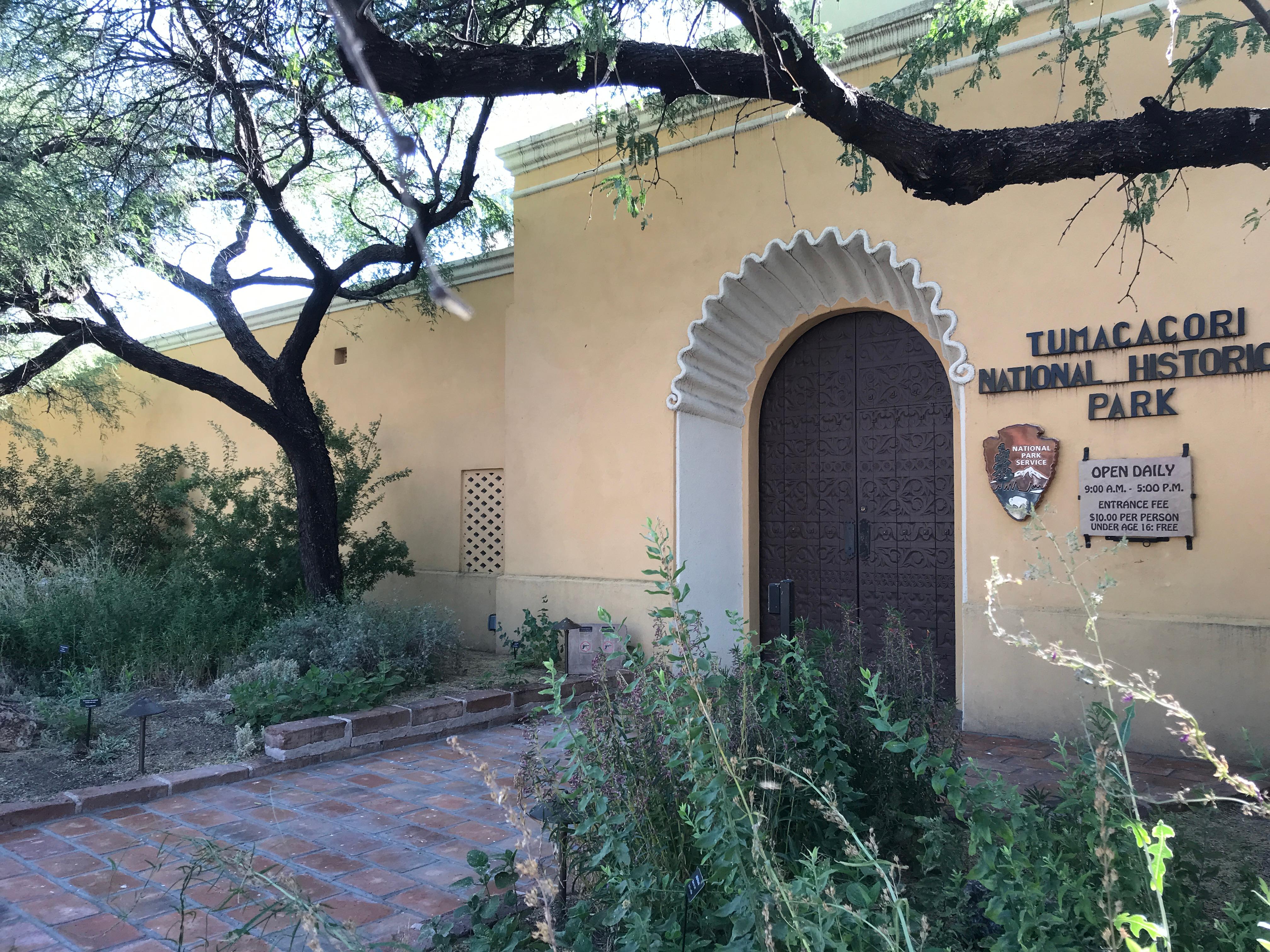
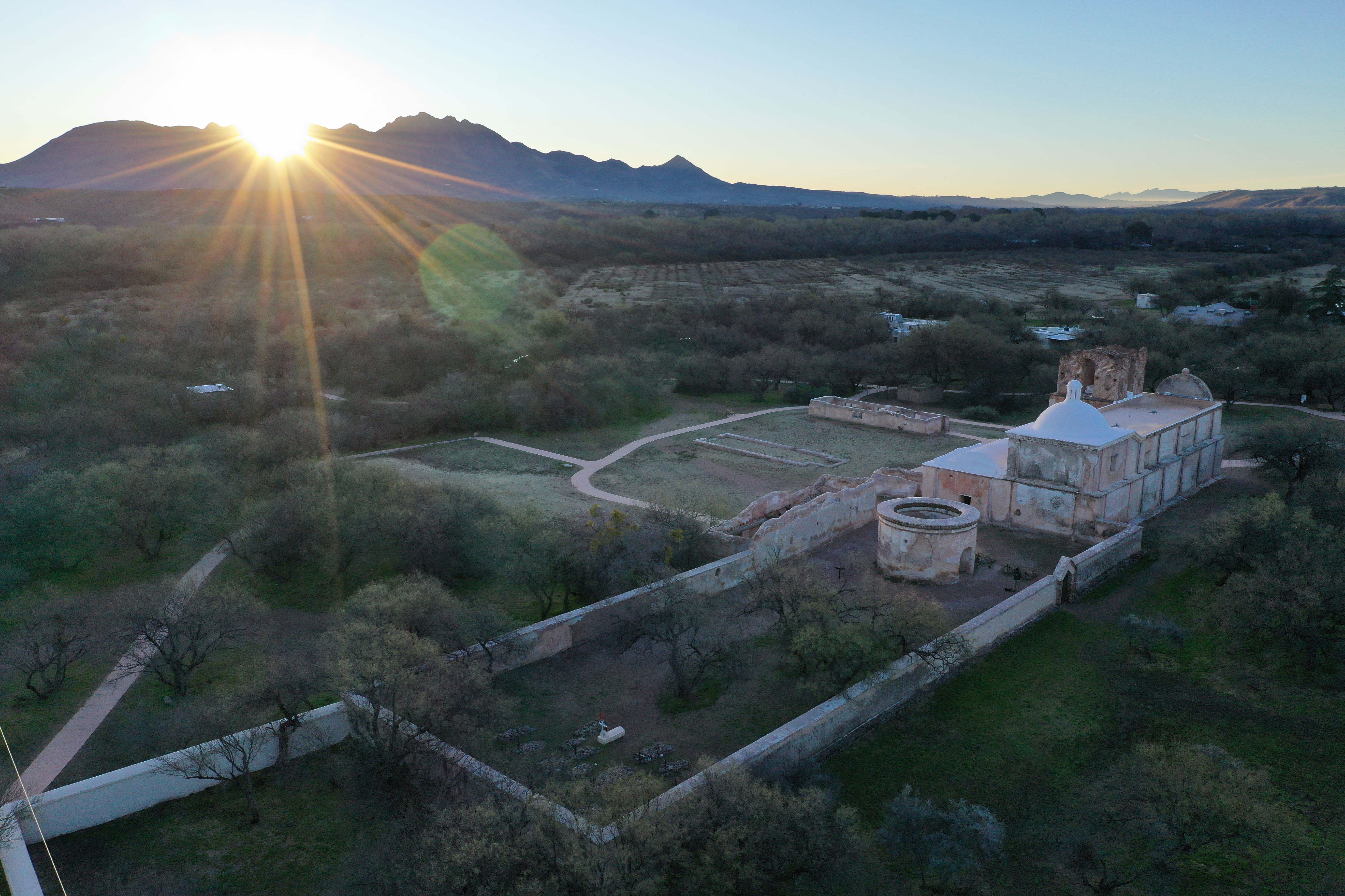
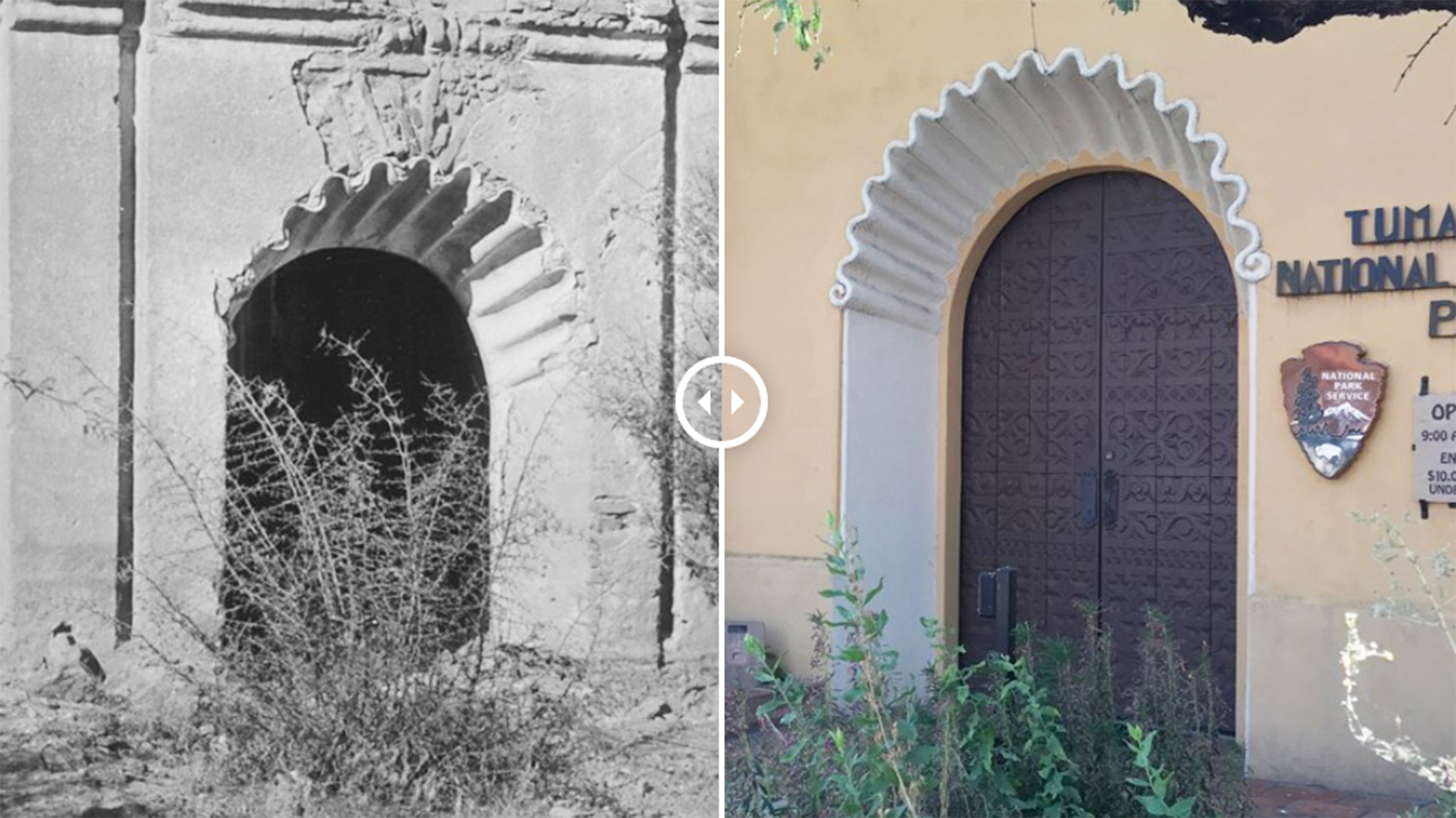
The historic 1937 visitor center building is the main entry point for those visiting the Tumacácori mission grounds. It is also an interpretive exhibit in and of itself. Its design uses architectural details from other Sonoran missions contemporary to Tumacácori.
Tumacácori National Historical Park actually includes THREE missions, not just one. Plan ahead to see Guevavi and Calabazas, two other sites south of the Tumacácori unit, but still part of the larger mission story.
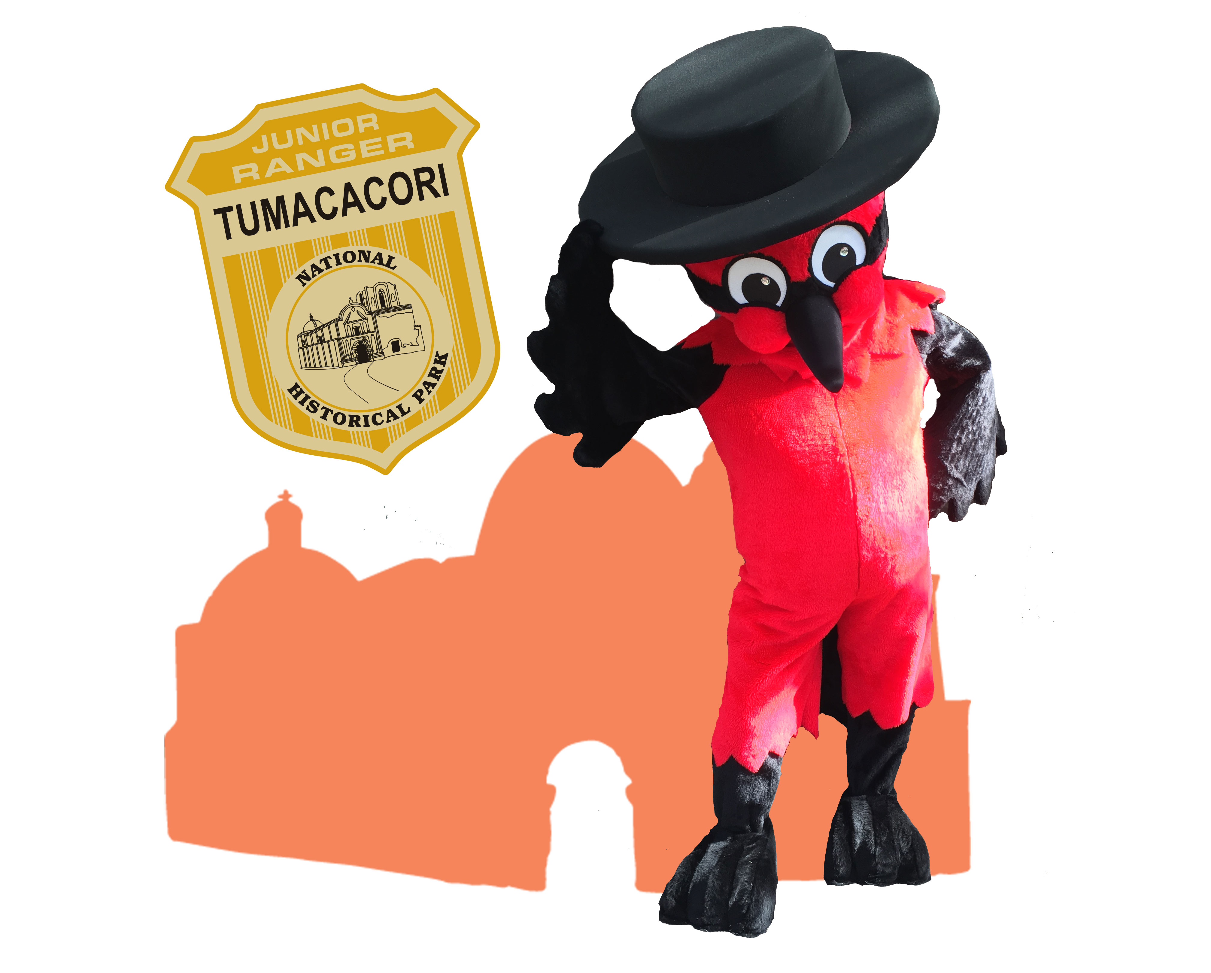
Become a Tumacácori Junior Ranger
The complex narrative of Tumacácori doesn't have to be dry or confusing. You just need the right feathered guide! Pancho the Vermilion Flycatcher will guide young Junior Rangers through the park. Older children explore the park following a visual treasure hunt.
Explore the Mission Grounds
The biggest draw to Tumacácori will likely be the grand, 3-story adobe church at its center. But a mission was much more than just a church. Explore the rest of the grounds, including the cemetery, orchard, and O'odham ki to get a fuller picture of what mission life entailed.
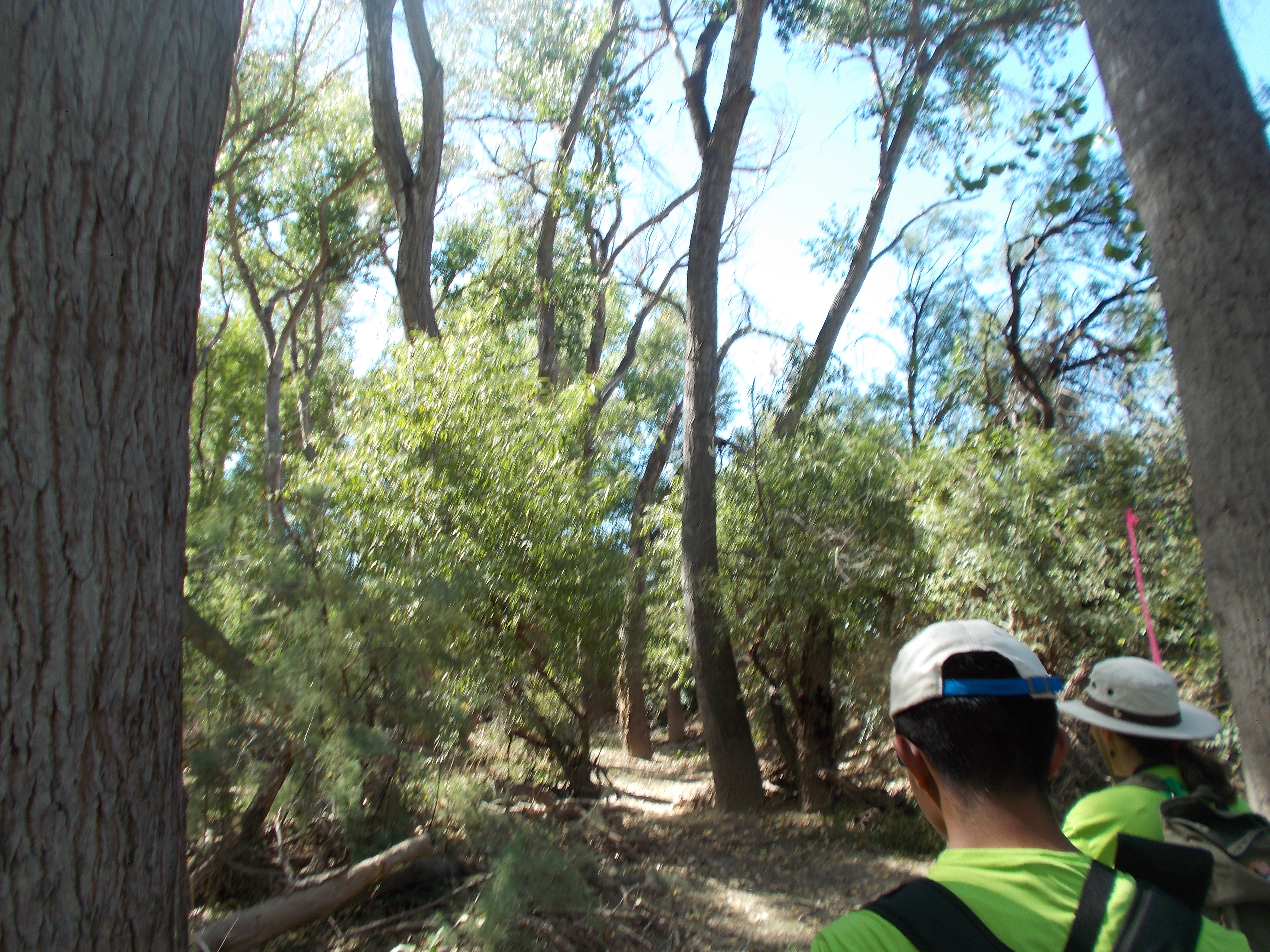
Hike the Santa Cruz River
The Santa Cruz River forms a ribbon of life in the Pimería Alta. Whether walking to its edge or along its length, visitors will encounter the fundamental building blocks of nature and human civilization.
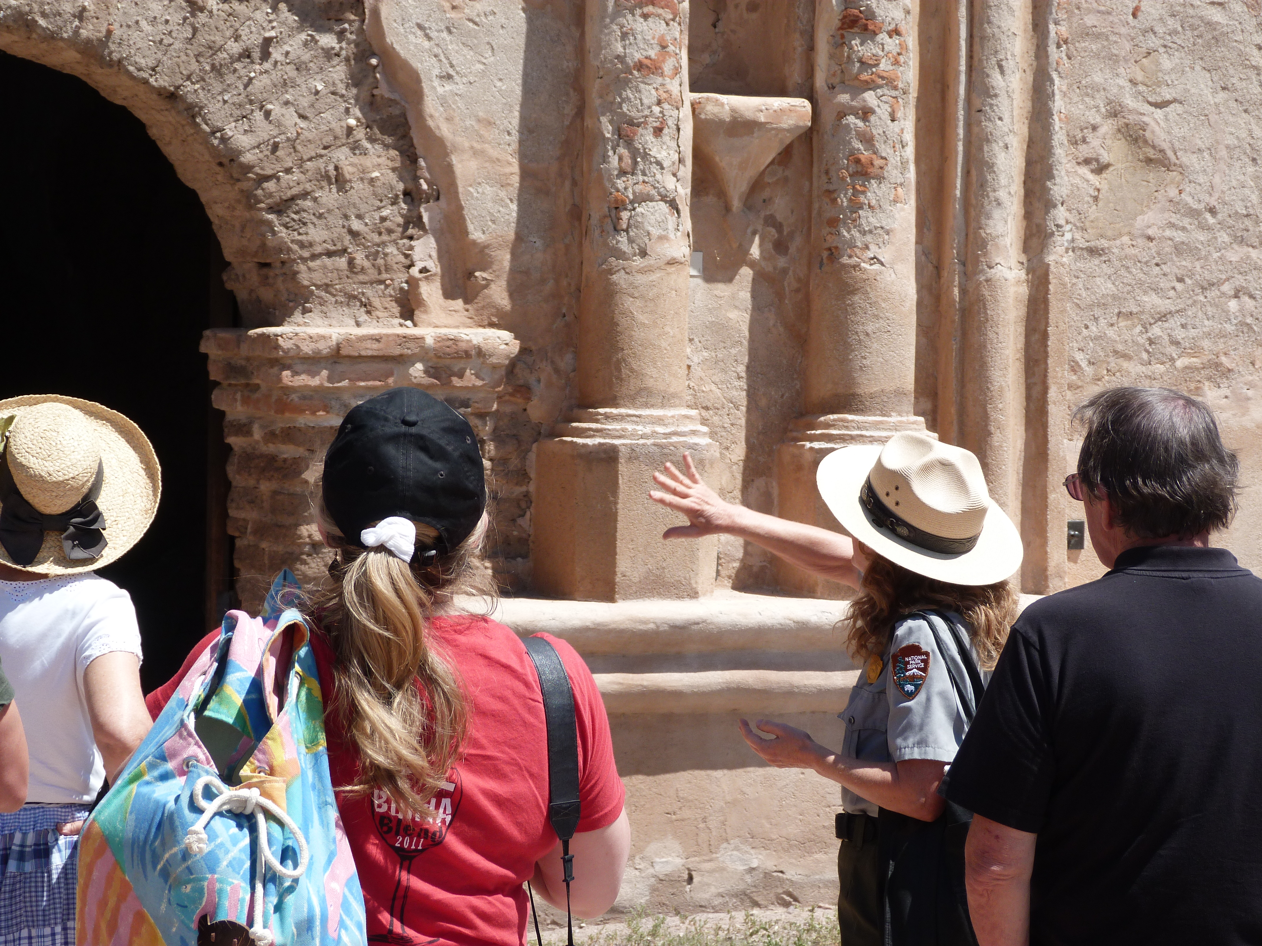
Join a Guided Tour
Guided tours of various types may be offered throughout the year. In park whose story is complex and nuanced, sometimes a knowledgeable guide can be a valuable asset. Join us!
Hike the Anza Trail from Tumacácori to Tubac, AZ
Hike through shady cottonwood galleries and mesquite bosques along this six-mile stretch of the Anza Trail between Tumacácori National Historic Park and Tubac Presidio State Historic Park.
Catch a Special Event
Live events like the annual La Fiesta de Tumacácori, bring history into the present. Demonstrations, performances, and activities can be found for all ages and abilities throughout the year.
Go Natural in a Historical Park
Nature in a historical park? Yes! The park's many habitats, both natural and cultivated, make its small area proportionally diverse.
Admire Art and Architecture
The visitor center and museum building was designed to be an interpretive experience that embodied the historic style of the mission churches in the area. In 1935, a group of National Park Service employees mounted an expedition to collect architectural information about churches in northern Sonora. Architectural features such as the carved wooden doors, arched portales, and corbels are details brought from this expedition to Mexico. Find them all!
Indulge Your Senses
A visit to Tumacácori may include a truly sensory experience with one of our historic craft demonstrators. These artisans demonstrate traditional crafts on the grounds of Mission San José de Tumacácori. Demonstrations may include tortilla making, paper flower making, O'odham basket weaving, leather working, or iron working.
Tours
Count: 4
El gran recorrido de Tumacácori (la misión + el río)
Tumacácori es más que una misión. Es un paisaje de personas, plantas, animales, historia y cultura. Tome el Gran Tour para explorar la historia del parque en su contexto completo, incluyendo el río y los ambientes circundantes.
Explora los terrenos de la misión
Pasee por las pasarelas pavimentadas por los terrenos de la misión.
Explore the Mission Grounds
Stroll the paved walkways through the mission grounds.
The Grand Tour of Tumacácori (mission grounds + river)
Tumacácori is more than a mission. It's a landscape of people, plants, animals, history, and culture. Take the Grand Tour to explore the park story in its full context, including the river and surrounding environments.