Be advised that the NPS has issued alerts for this park.
Backcountry Camping Closed
Backcountry camping at the park is closed. There is no established opening date at this time.
Interdune Boardwalk Closed
Due to the active safety corridor, the Interdune Boardwalk is closed. Please visit the park visitor center to learn about other options during your visit.
Dunes Drive Safety Corridor
Dunes Drive is open. A safety corridor is in effect between mile marker 3 and 5.5 along Dunes Drive. Visitors may drive but not stop or exit their vehicle in this area.
Park Closures
From time to time the missile range that surrounds the park performs military testing that may require the closure of the park or Highway 70. Please plan your visit around upcoming military tests.
RV and Tractor Trailer Parking at the Visitor Center
There is limited space for parking for recreational vehicles and trailers in the parking lot directly in front (south) of the visitor center. RVs are asked to not park in the lot behind the visitor center. There is no parking space for tractor trailers.
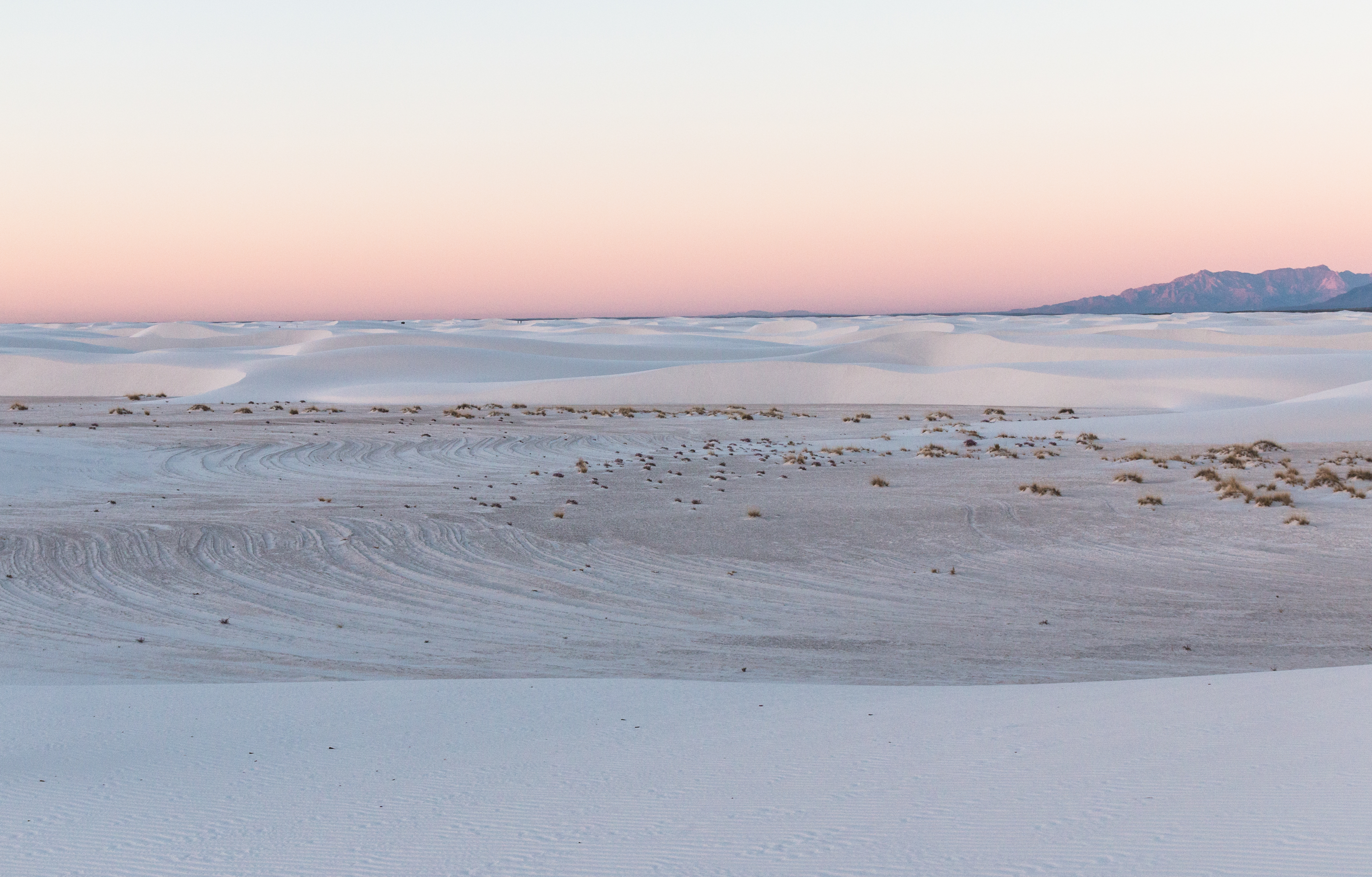
Rising from the heart of the Tularosa Basin is one of the world's great natural wonders - the glistening white sands of New Mexico. Great wave-like dunes of gypsum sand have engulfed 275 square miles of desert, creating the world's largest gypsum...
Per vehicle fee is charged to visitors for entry by a single, private non-commercial vehicle. Entrance fees are valid for reentry for seven consecutive days from the date of purchase.
Entrance - Per Person
$15.00
Per person fee is charged to visitors for entry by means other than a single, private non-commercial vehicle. This includes, but is not limited to, individuals who enter the park by walking and bicycling. Entrance fees are valid for reentry for seven consecutive days from the date of purchase.
Entrance - Motorcycle
$20.00
Entrance fees are valid for entry for seven consecutive days from the date of purchase.
Commercial Entrance - Van
$50.00
Commercial bus/van tours are charged a flat rate based on the capacity of the vehicle (not the number of persons on board).
Commercial Entrance - Mini-bus
$60.00
Commercial bus/van tours are charged a flat rate based on the capacity of the vehicle (not the number of persons on board).
Commercial Entrance - Motor Coach
$150.00
Commercial bus/van tours are charged a flat rate based on the capacity of the vehicle (not the number of persons on board).
Permits are sold on a same day, first-come, first-served basis at the entrance station.
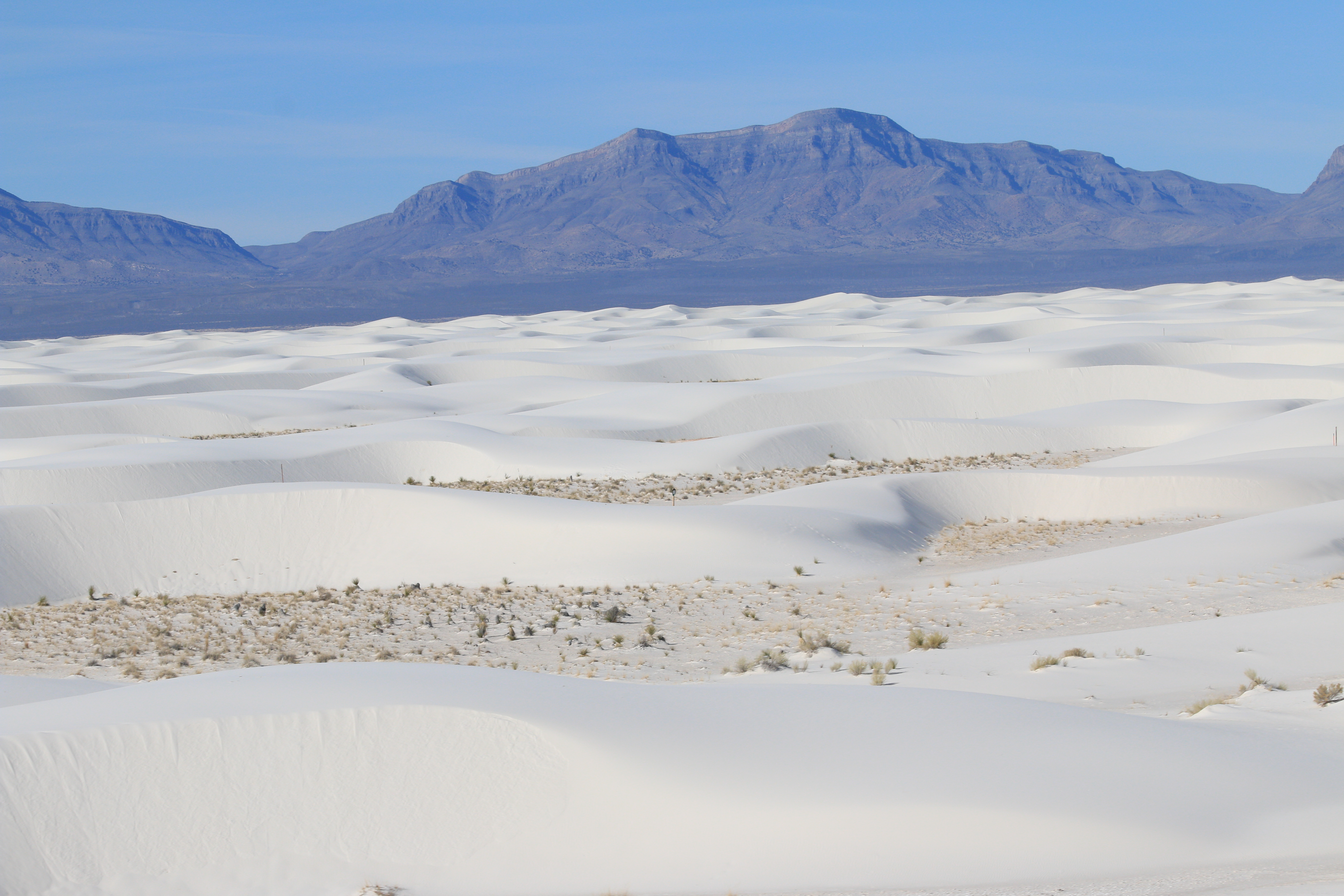
The backcountry camping trail is located directly in the dunefield, surrounded by white sand dunes that can be as tall as 36 feet. Two separate mountain ranges are visible to the east and west. Ten campsites are spread out over the entirety of the two-mile loop trail, and are marked by brown wooden posts that emerge straight up from the ground. Fixed to these posts are small square signs with campsite numbers ranging from 1-10, arrows pointing in the direction of each site, and a small brown square showing two white silhouettes of gender-neutral hikers with walking sticks and backpacks. The sites themselves are located in the inner dune areas, which are the flat low points between dunes. The ground here is hard-packed, firmer, and often slightly darker than the soft white sand found in the dunes themselves. In some of the sites and along parts of the trail, you can find bushels of varying types of grasses, which tend to be around 1-2 feet tall and dark green and tan in color. There may also be other types of vegetation along the trail and in the campsites, including the soaptree yucca. Depending on the season, the yucca have two main components: their bayonet leaves, which are dark green, about an inch wide, and sharp enough at the tips to warrant their name; and the stem, which is a tall, woody feature that stands vertically from the base and is often over five feet tall. When a stem is present, many creamy white flowers rest on its tip. The flower petals harden after they bloom in late spring, and transform into firm capsules that house the yucca’s dark brown, round seeds. Each site is marked by a bright orange post that protrudes from the ground, with the site number on it.
This is one of many family-friendly interpretive exhibits on the Dune Life Nature Trail at White Sands National Park.
This sign, about two feet wide and one and one-half feet high, is mounted at an angle on a single metal post. The sign sits about halfway up a slope as the trail climbs towards the top of a dune ridge. More ridges sit on either side of the trail. All around the white sand gleams, dotted here and there with grey-green vegetation – grasses and small bushes. The sign has a picture of Katie, the cartoon fox figure, in the upper left, with text in both English and Spanish along the top. The bottom part of the sign has a picture of a kit fox, with its red-brown fur and large, white-lined ears. It stands near a bush on top of a sand pedestal holding a dead rodent in its mouth. A black hole gapes in the side of the pedestal below the fox. Text at the top reads, “Look at me on top of my pedestal! I like it up there because I can see all around. I prefer to stay in my pedestal during the fierce heat of the day. A den dug deep stays nice and cool in the summer. Only after sundown do I come out and look for food. My large ears help me find lizards, insects, kangaroo rats, and small birds. I must be quick to catch my food!”
This is one of several family-friendly interpretive exhibits on Dune Life Nature Trail at White Sands National Park.
This sign, about two feet wide and one and one-half feet high, is mounted at an angle on a single metal post. As you face the sign one trail marker is visible about 20 yards ahead and another one a bit further than that behind you. The ground is fairly level here, the white sand mostly firm underfoot with small hillocks rising here and there with grey-green brush on top. The sign has a picture of Katie, the cartoon fox figure, in the upper left, with text in both English and Spanish along the top. The bottom part of the sign has a picture of a soaptree yucca plant, a mound of sword-like green leaves at the bottom and a huge cluster of white blossoms held high on a thick stalk. To the right is an enlarged picture of one white blossom with cup-like petals and a white pistol and stamen. Three white yucca moths, wings folded, sit inside the blossom. Text at the top reads, “I know two friends so close that they just could not live without each other. Have you ever had a friend like that? Yucca moths and soaptree yuccas are exactly like that. The moths carry pollen from flower to flower. No moths? No new seeds. The one place where a yucca moth egg is safe, until it hatches, is inside a yucca pod.”
This is one of many family-friendly interpretive exhibits on Dune Life Nature Trail at White Sands National Park.
This sign, about two feet wide and two and one-half feet high, is mounted at an angle on a single metal post. As you face the sign it sits part way up a slope as the trail climbs up out of the flat basin behind you. The smooth white sand stretches out on either side of you with a patch of dunewood, remnants of dead trees, to your left. Behind you the trail skirts the edge of the grass-covered basin which extends below the ridge to your left. The sign has a picture of Katie, the cartoon fox figure, in the upper left, with text in both English and Spanish along the top. The bottom part of the sign has a picture of a Lesser Nighthawk gliding with its wings outstretched. It is brown with double rows of grey dots and of orange dots along its wings and a white bar near each wing tip. Text near the top reads, “Do you have friends who will eat anything? My nighthawk friends are good at doing just that! At sunset, you may see them zooming overhead, mouths wide open, scooping up moths, beetles, grasshoppers, winged termites, and flying ants! In the fall, some of these birds will fly all the way to Brazil, which is like flying from Los Angeles to New York and back. Imagine all the weird bugs they can gobble along the way!”
This is one of many family-friendly interpretive exhibits on the Dune Life Nature Trail at White Sands National Park.
This sign, about two feet wide and one and one-half feet high, is mounted at an angle on a single metal post. The sign sits along the trail as it follows the bottom of a sandy ridge rising on your left. To your right and slightly below you is a grass-covered flat basin. The sign has a picture of Katie, the cartoon fox figure, in the upper left, with text in both English and Spanish along the top. The bottom part of the sign has a picture of a wasp called a Tarantula Hawk and a Desert Tarantula fighting one another. The wasp is black, its rusty-brown wings folded over its back. The tarantula is brown with hair covering its body and its legs. Text at the top reads, “Some of my friends like to be left alone. The tarantula hawk lives alone and hunts alone. Her prey, the tarantula spider, is bigger, hairier, and more venomous. When this wasp finds a tarantula away from its lair, a death match begins. If she wins, she paralyzes the spider and lays one egg inside it. She drags it to her hideout and seals it underground. After hatching, the young wasp eats the spider from the inside out.”
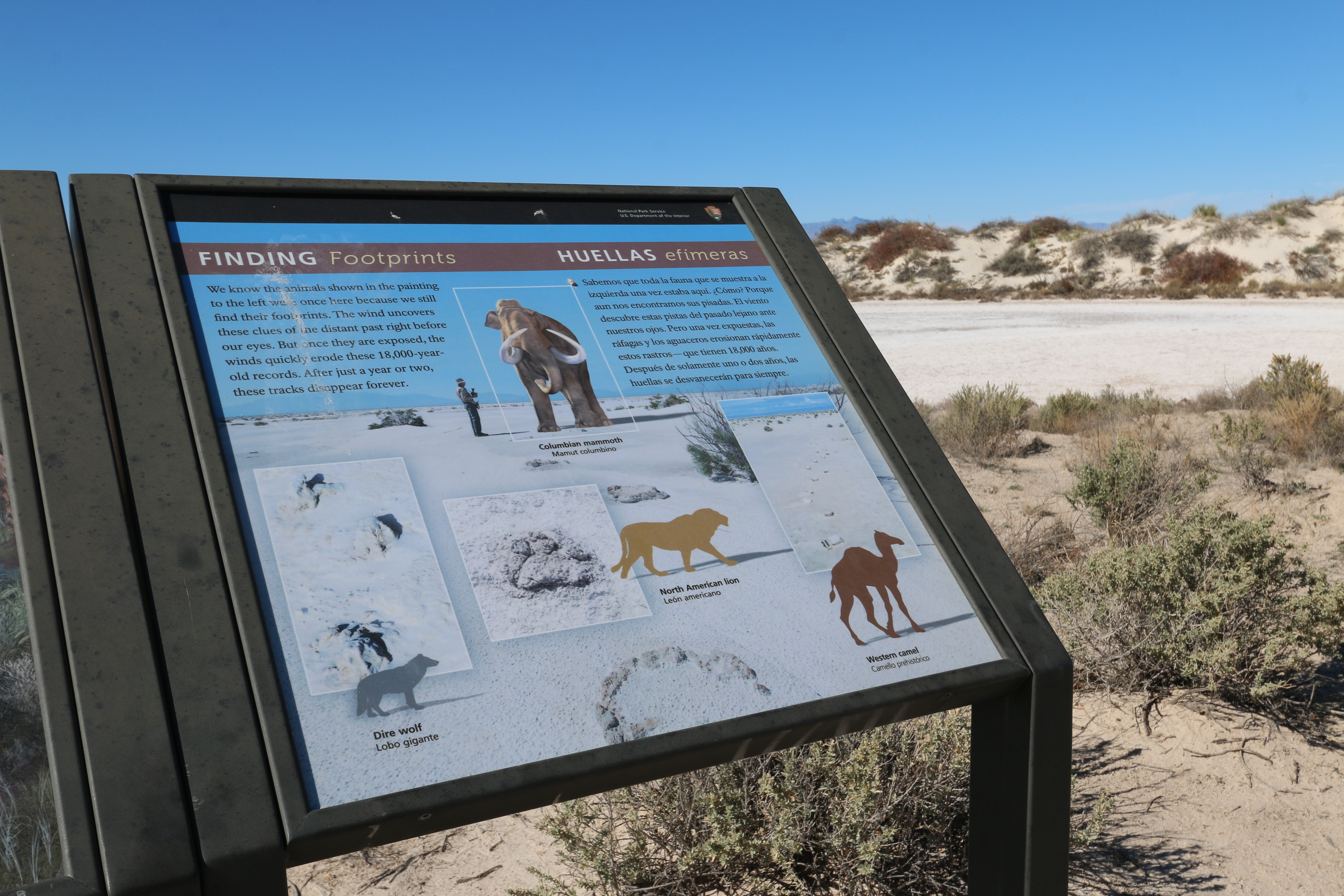
This is one of several interpretive exhibits along the Playa Trail at White Sands National Park.
This 2-foot by 2-foot sign stands next to the “Wetter, Bigger, Badder” sign at the end of the Playa Trail. It shows a man standing on the white, crusty bed of the dry playa. Next to him is an illustration of a Columbian mammoth, standing over twice the man’s height at the shoulder. In the foreground is a line of huge round footprints leading towards the mammoth. At bottom left of the sign are three raised mounds that look like a plaster cast of a paw print. A silhouette of a dire wolf is shown next to them. In the center is the silhouette of a North American lion and a large paw print with a central pad and three toes clearly seen. At left is a line of double-toed tracks like a deer track next to a silhouette of a western camel. Text at the top reads, “We know the animals shown in the painting to the left were once here because we still find their footprints. The wind uncovers these clues of the distant past right before our eyes. But once they are exposed, the winds quickly erode these 18,000-year-old records. After just a year or two, these tracks disappear forever.”
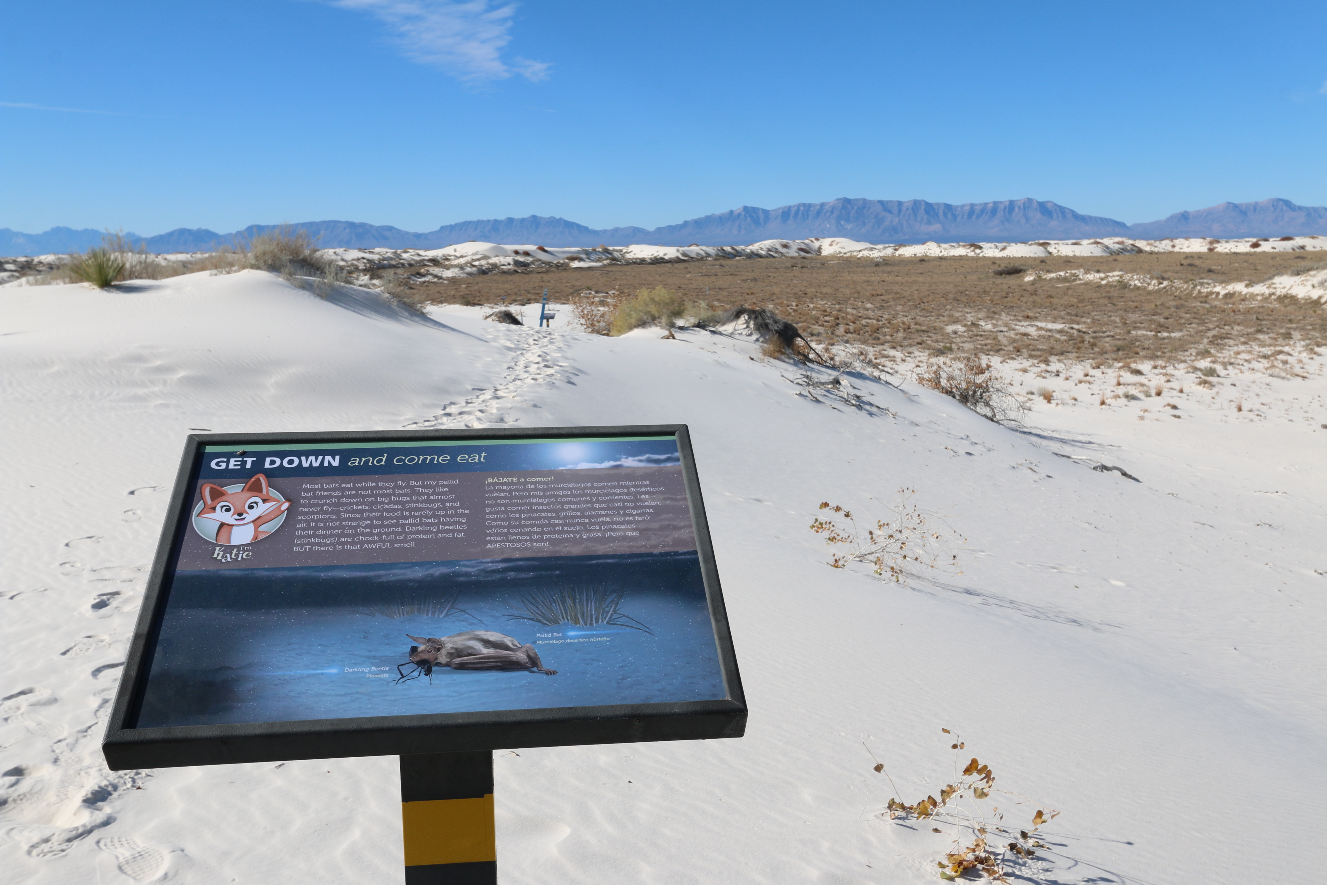
This is one of many family-friendly interpretive signs on Dune Life Nature Trail at White Sands National Park.
This sign, about two feet wide and one and one-half feet high, is mounted at an angle on a single metal post. It is mounted just down the slope from a small clump of scrubby cottonwood trees. The trees are short, almost bush-like in appearance with white bark and broad leaves that are almost heart-shaped. Past the sign as you face it, the trail continues downslope as the small ridge you are on drops down to a brush-covered flat basin. To the right the sand is broad and smooth. To the left, the side of the dune ridge falls off very steeply just past a group of yucca plants with their sword-like leaves. The sign has a picture of Katie, the cartoon fox figure, in the upper left, with text in both English and Spanish along the top. The bottom part of the sign has a picture of a brown bat, lying on the ground with wings folded, a large black insect in its mouth. Labels identify the animals as the Pallid Bat and the Darkling Beetle. Text at the top reads, “Most bats eat while they fly. But my pallid bat friends are not most bats. They like to crunch down on big bugs that almost never fly—crickets, cicadas, stinkbugs, and scorpions. Since their food is rarely up in the air, it is not strange to see pallid bats having their dinner on the ground. Darkling beetles (stinkbugs) are chock-full of protein and fat, BUT there is that AWFUL smell.”
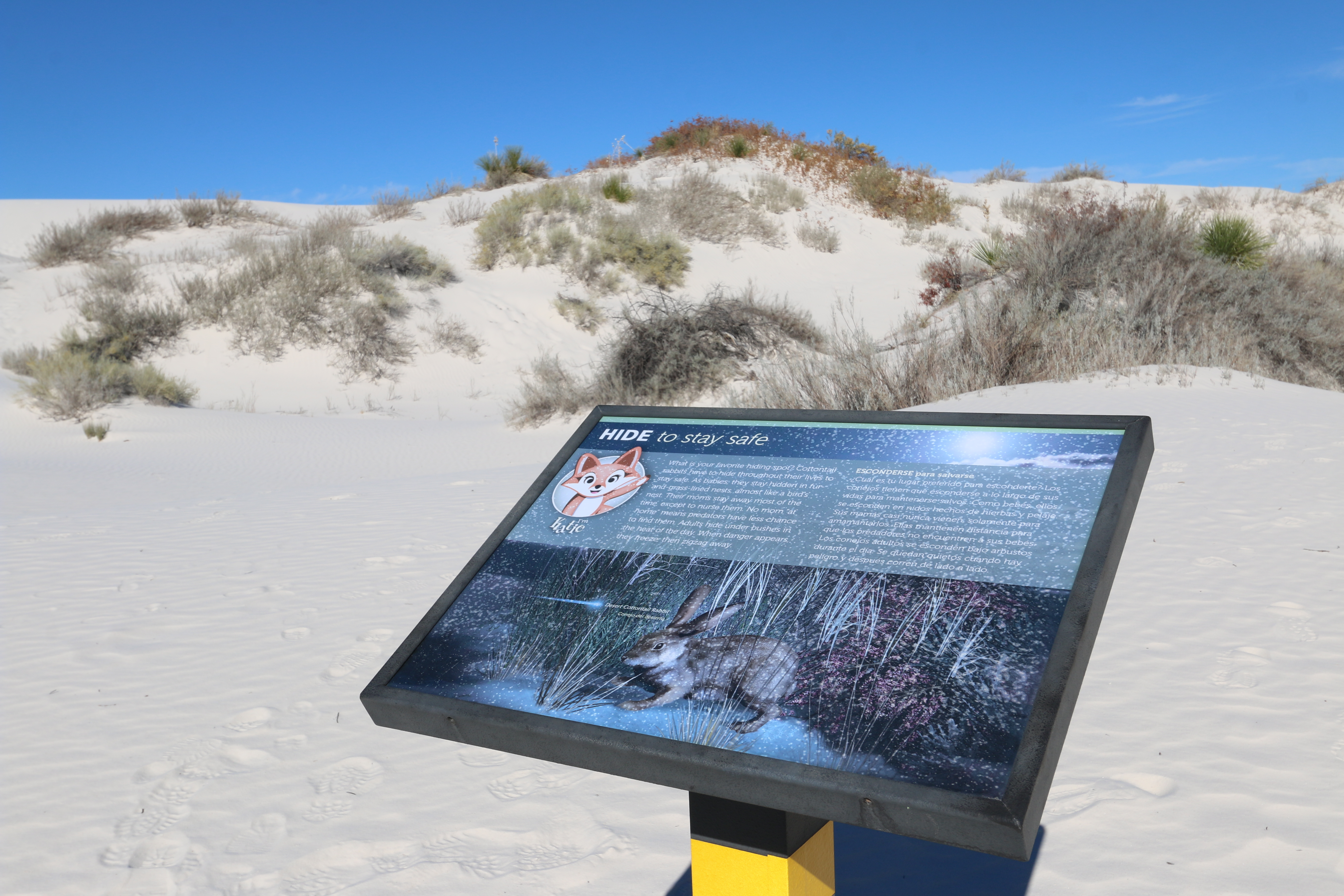
This is one of many family-friendly interpretive exhibits on Dune Life Nature Trail at White Sands National Park.
This sign, about two feet wide and one and one-half feet high, is mounted at an angle on a single metal post. The sign sits at the top of a slope that climbs out of a small basin between two ridges. Facing the sign, the trail continues across the width of the ridge to the two large pedestals which mark the place that the trail ascends from the parking lot below, and the beginning of this loop trail through the dunes. The sign has a picture of Katie, the cartoon fox figure, in the upper left, with text in both English and Spanish along the top. The bottom part of the sign has a picture of a Desert Cottontail Rabbit, crouched on all four legs, its huge ears raised alertly over its head. Text at the top reads, “What is your favorite hiding spot? Cottontail rabbits have to hide throughout their lives to stay safe. As babies, they stay hidden in fur-and- grass-lined nests, almost like a bird’s nest. Their moms stay away most of the time, except to nurse them. No mom “at home” means predators have less chance to find them. Adults hide under bushes in the heat of the day. When danger appears, they freeze, then zigzag away.”
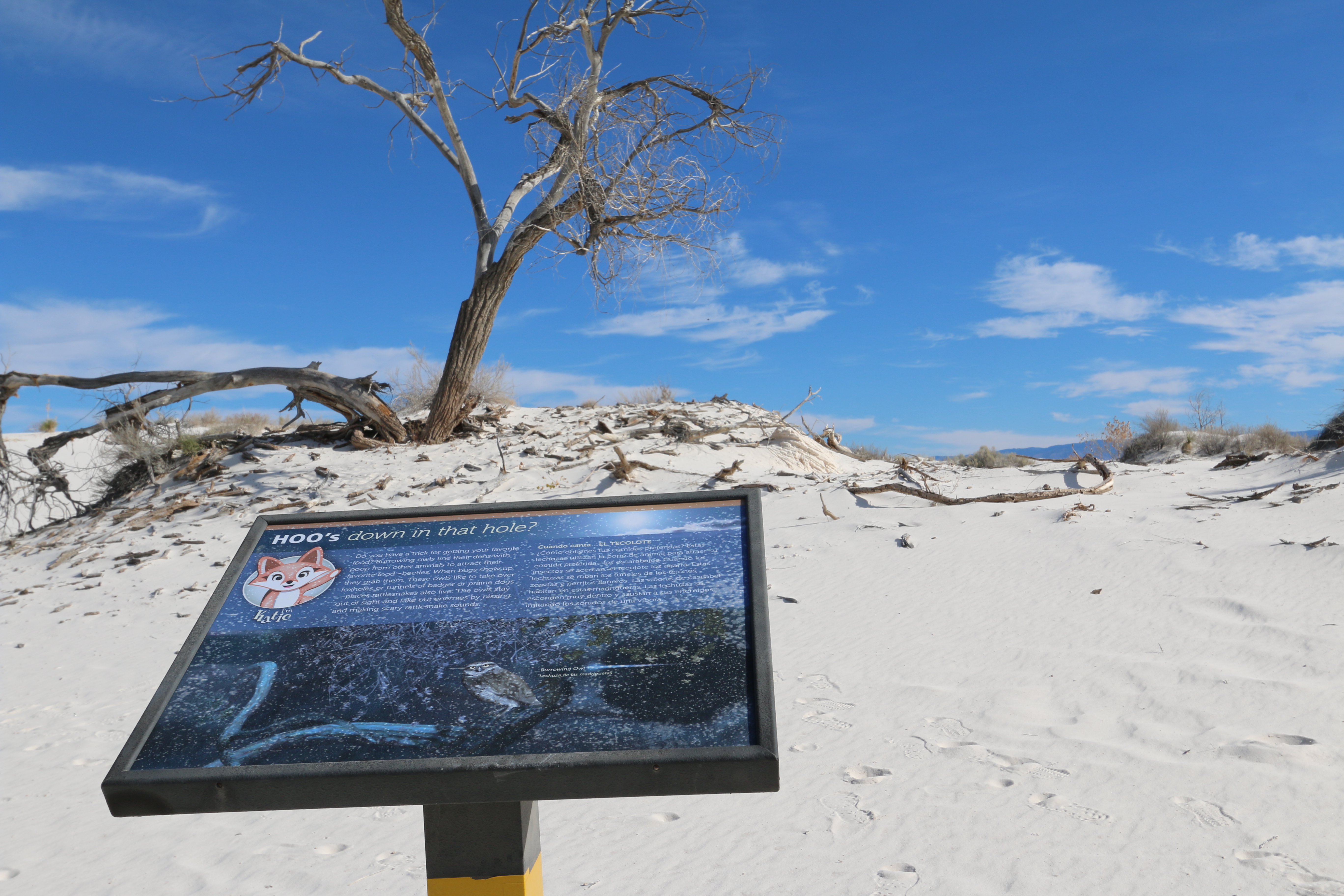
This is one of many family-friendly interpretive exhibits on the Dune Life Nature Trail at White Sands National Park.
This sign, about two feet wide and one and one-half feet high, is mounted at an angle on a single metal post. Past the sign as you face it is a dead tree standing at the top of a small ridge. To your left, the trail curves to the left as it skirts the bottom of the small ridge. Behind you is a flat, grass covered basin surrounded by the low dunes. The sign has a picture of Katie, the cartoon fox figure, in the upper left, with text in both English and Spanish along the top. The bottom part of the sign has a picture of a Burrowing Owl perched on a gnarled tree branch. Its back is brown with tan spots. Its head and breast are also tan with a brown cap and a brown mask around its big yellow eyes. Text at the top reads, “Do you have a trick for getting your favorite food? Burrowing owls line their dens with poop from other animals to attract their favorite food—beetles. When bugs show up, they grab them. These owls like to take over foxholes or tunnels of badger or prairie dogs —places rattlesnakes also live. The owls stay out of sight and fake out enemies by hissing and making scary rattlesnake sounds.”
This is one of many family-friendly interpretive exhibits on the Dune Life Nature Trail at White Sands National Park.
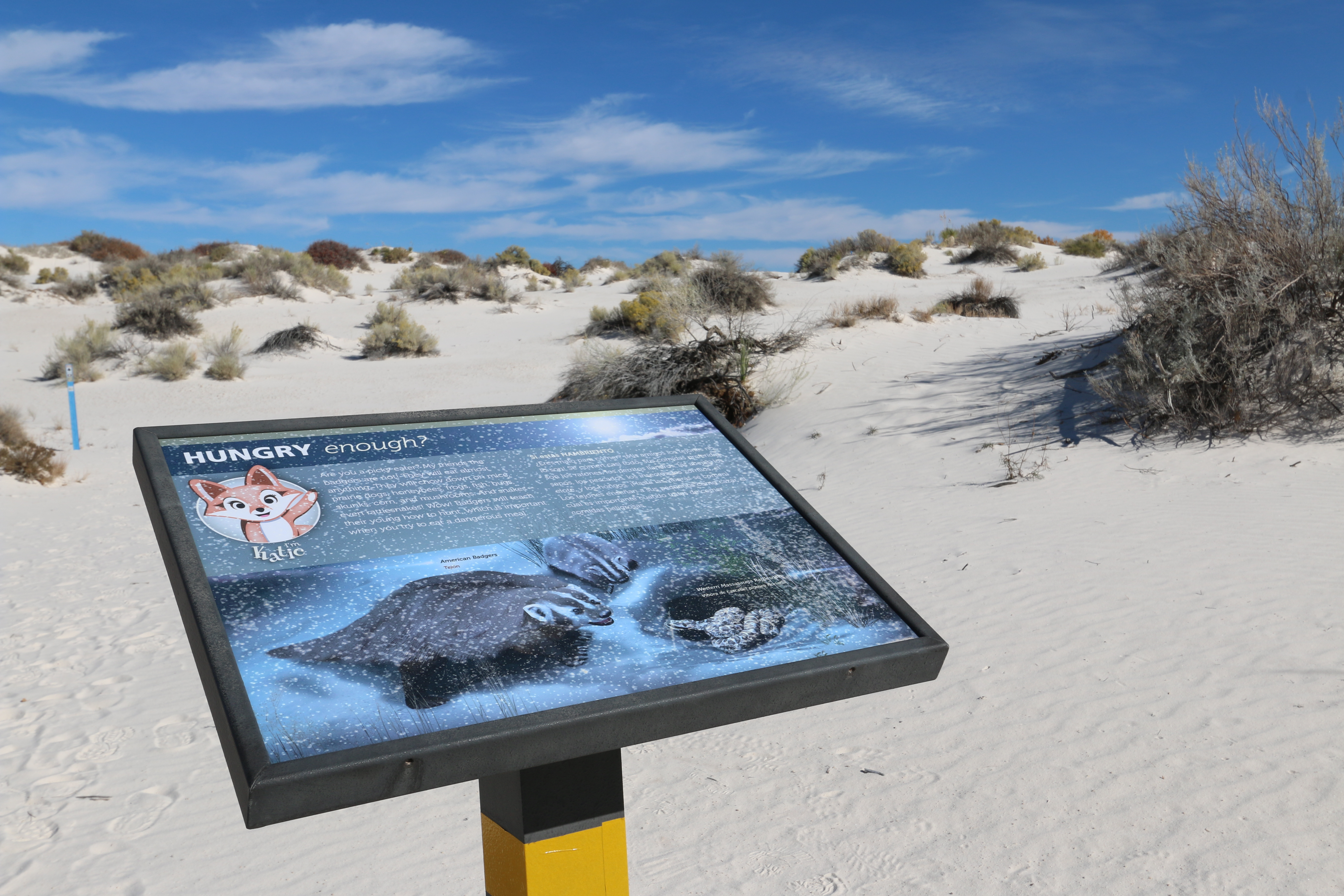
This sign, about two feet wide and one and one-half feet high, is mounted at an angle on a single metal post. The sign sits along the trail as it makes a gentle “S” curve to your left, winding its way up the low ridge ahead of you. To the left, a small flat grassy area sits between the ridge ahead and the ridge whose shoulder sits behind you. Another ridge sits to your right, dotted with yucca and small shrubs. The sign has a picture of Katie, the cartoon fox figure, in the upper left, with text in both English and Spanish along the top. The bottom part of the sign has a picture of two American Badgers on the left facing a coiled Western Massasauga Rattlesnake on the right. The badgers are brown with a white stripe running from the nose over the top of their heads. More white stripes run from the corner of their mouths, around their eyes to the base of their white ears. The rattlesnake has brown and white stripes circling its body. Text at the top reads, “Are you a picky eater? My friends the badgers are not! They will eat almost anything. They will chow down on mice, prairie dogs, honeybees, frogs, fish, bugs, skunks, corn, and mushrooms. And snakes—even rattlesnakes! Wow! Badgers will teach their young how to hunt, which is important when you try to eat a dangerous meal.”
This is one of many family-friendly interpretive exhibits on the Dune Life Nature Trail at White Sands National Park.
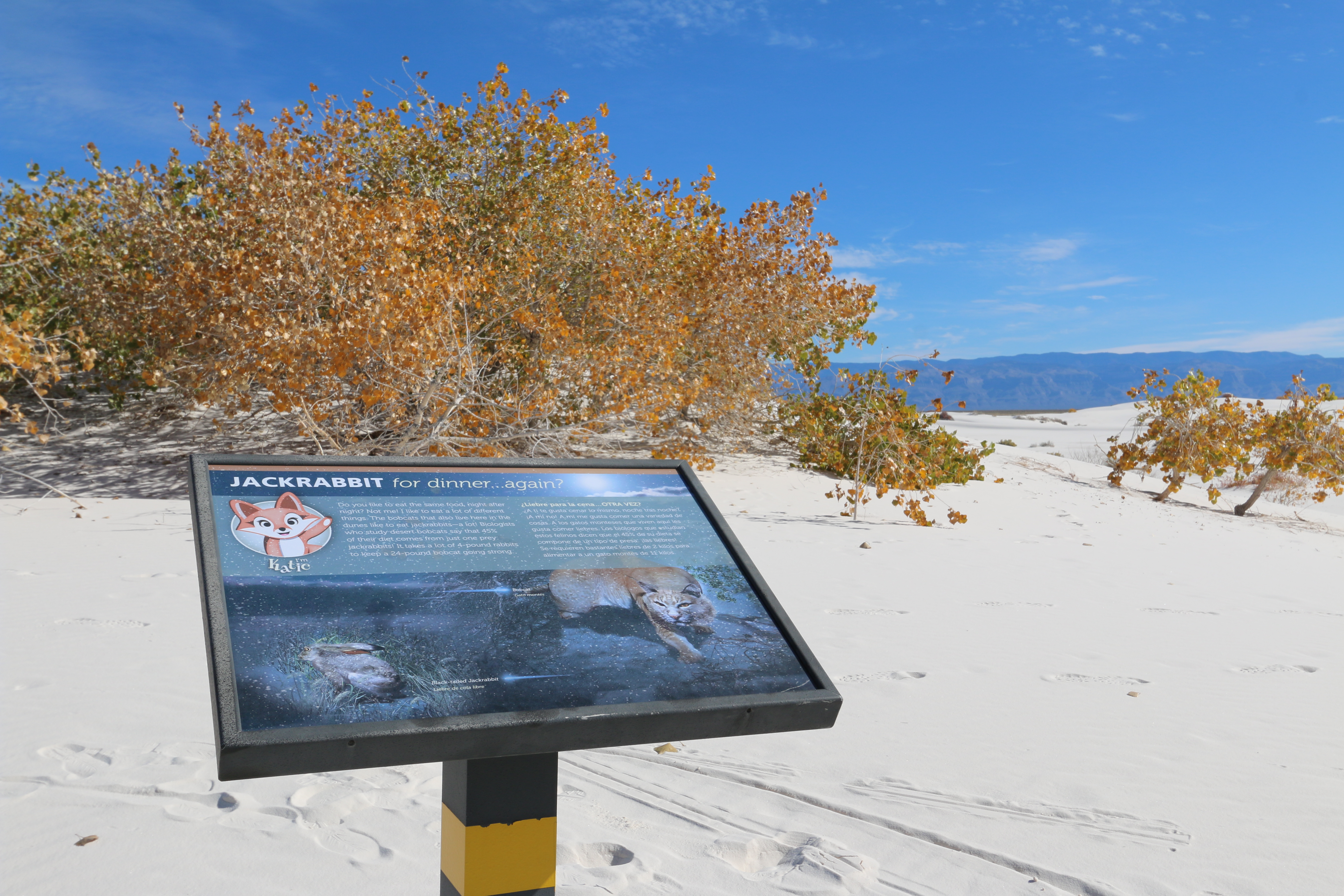
This sign, about 2 feet wide and one and one-half feet high, is mounted at an angle on a single metal post. The sign sits near the top of a smooth sand dune, which extends even higher slightly to your left. Directly past the sign is a small clump of scrubby cottonwood trees, looking like large bushes. Behind you and to the right, the sand slopes downward to the grass covered basin floor below. The trail continues to your right and slightly downward as it rounds the shoulder of the big dune you are standing on. The sign has a picture of Katie, the cartoon fox figure, in the upper left, with text in both English and Spanish along the top. The bottom part of the sign has a picture of a bobcat, crouched down as it slinks towards us. It has light brown, dappled fur and amber eyes. In the lower left of the sign is a picture of a Black-tailed Jackrabbit sitting with its long ears laid down along its back, its wide eyes staring off to the left. Text at the top reads, “Do you like to eat the same food, night after night? Not me! I like to eat a lot of different things. The bobcats that also live here in the dunes like to eat jackrabbits—a lot! Biologists who study desert bobcats say that 45% of their diet comes from just one prey: jackrabbits! It takes a lot of 4-pound rabbits to keep a 24-pound bobcat going strong.”
This is one of several interpretive exhibits on the Playa Trail at White Sands National Park.
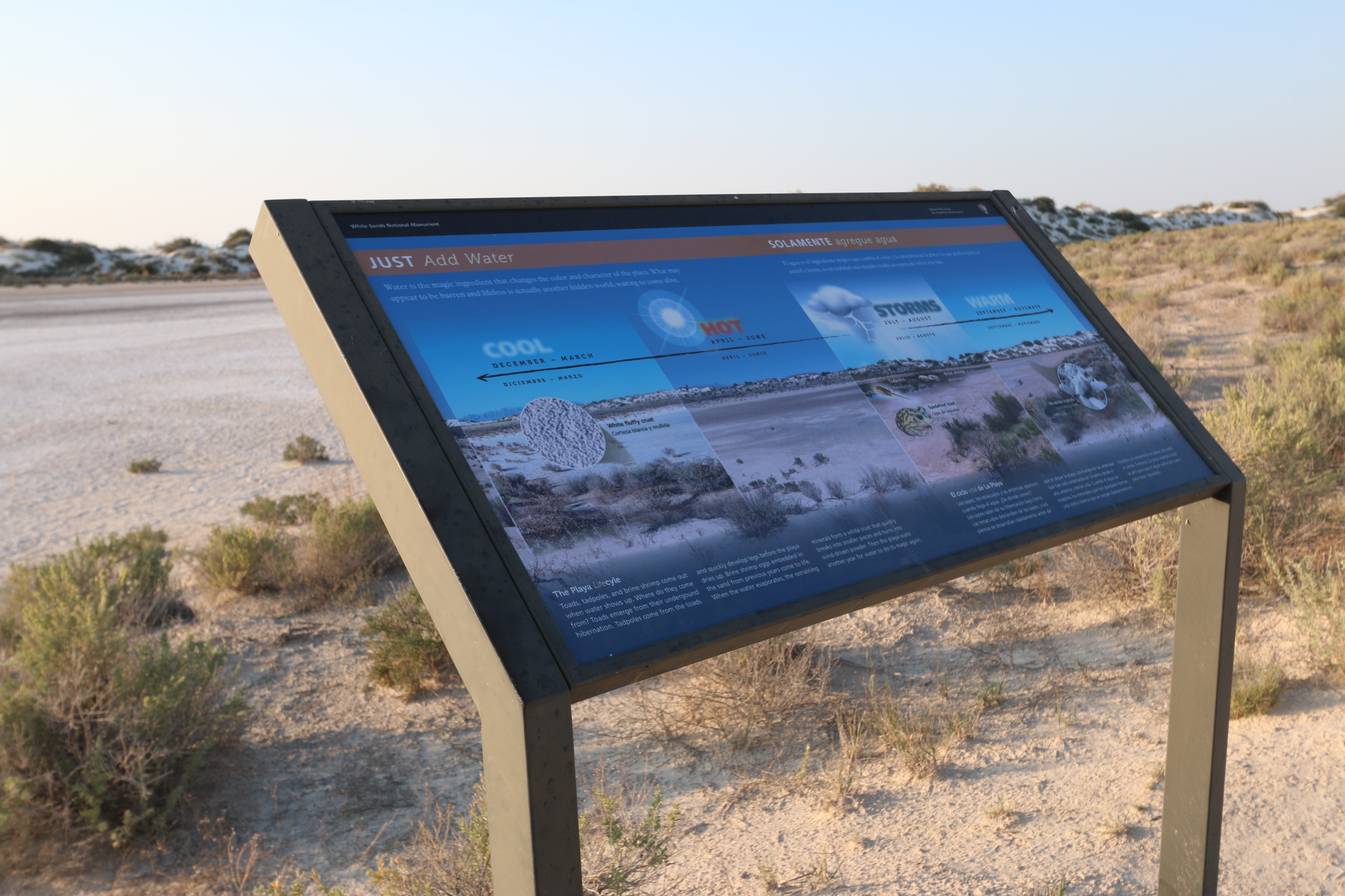
This 4-foot by 2-foot sign stands in a metal frame close to the edge of the wide, main body of the playa. As you face the sign, a low ridge of dunes is visible on the far side of the playa. The trail continues on through the brush to the right and the trail back to the road lies on your left. The background of the sign features a picture of the playa from a perspective close to that of your current position. Vertical lines separate the picture into four sections corresponding to times of the year. Text above and below the picture is in both English and Spanish. At the top it reads, “Water is the magic ingredient that changes the color and character of the playa. What may appear to be barren and lifeless is actually another hidden world, waiting to come alive.” Text at the bottom reads, “Toads, tadpoles, and shrimp come out when water shows up. Where do they come from? Toads emerge from their underground hibernation. Tadpoles come from the toads and quickly develop legs before the playa dries up. Brine shrimp eggs embedded in the sand from previous years come to life. When the water evaporates, the remaining minerals form a white crust that quickly breaks into smaller pieces and turns into wind-driven powder. Then the playa waits another year for water to do its magic again.” From left to right the first section is labeled “Cool, December to March.” It shows a detailed picture of white fluffy crust. The next section is Hot, April to June. It shows a hot sun over the barren, dry playa. The third section is Storms, July to August. It shows a picture of a storm cloud as well as pictures of tadpoles, brine shrimp and a Spadefoot Toad. The last section is Warm, September to November. It again shows the dry playa with a picture of bright white mirabilite crystals, thin flat oblongs.
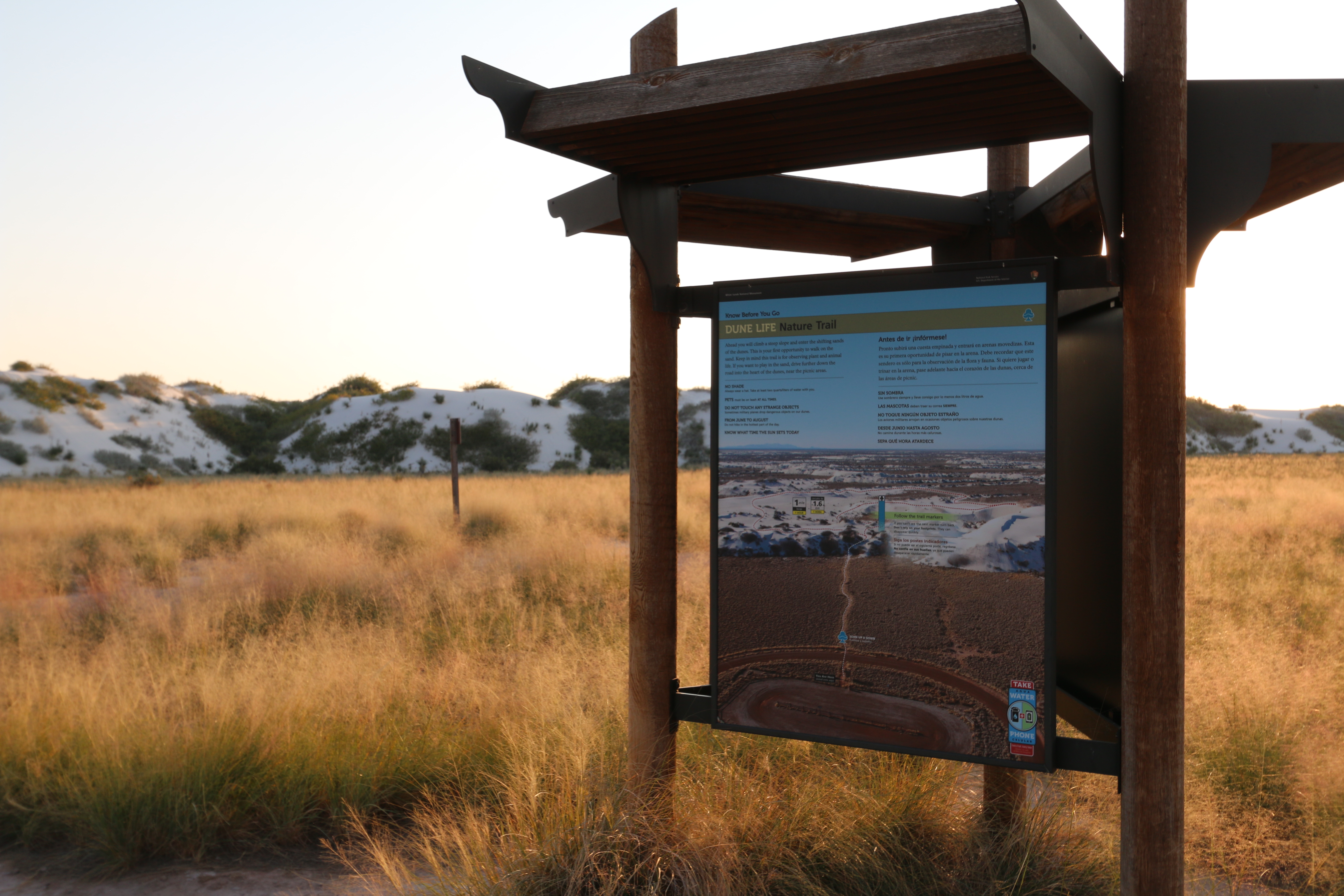
This is one of the interpretive kiosk panels at the Dune Life Nature Trail trailhead.
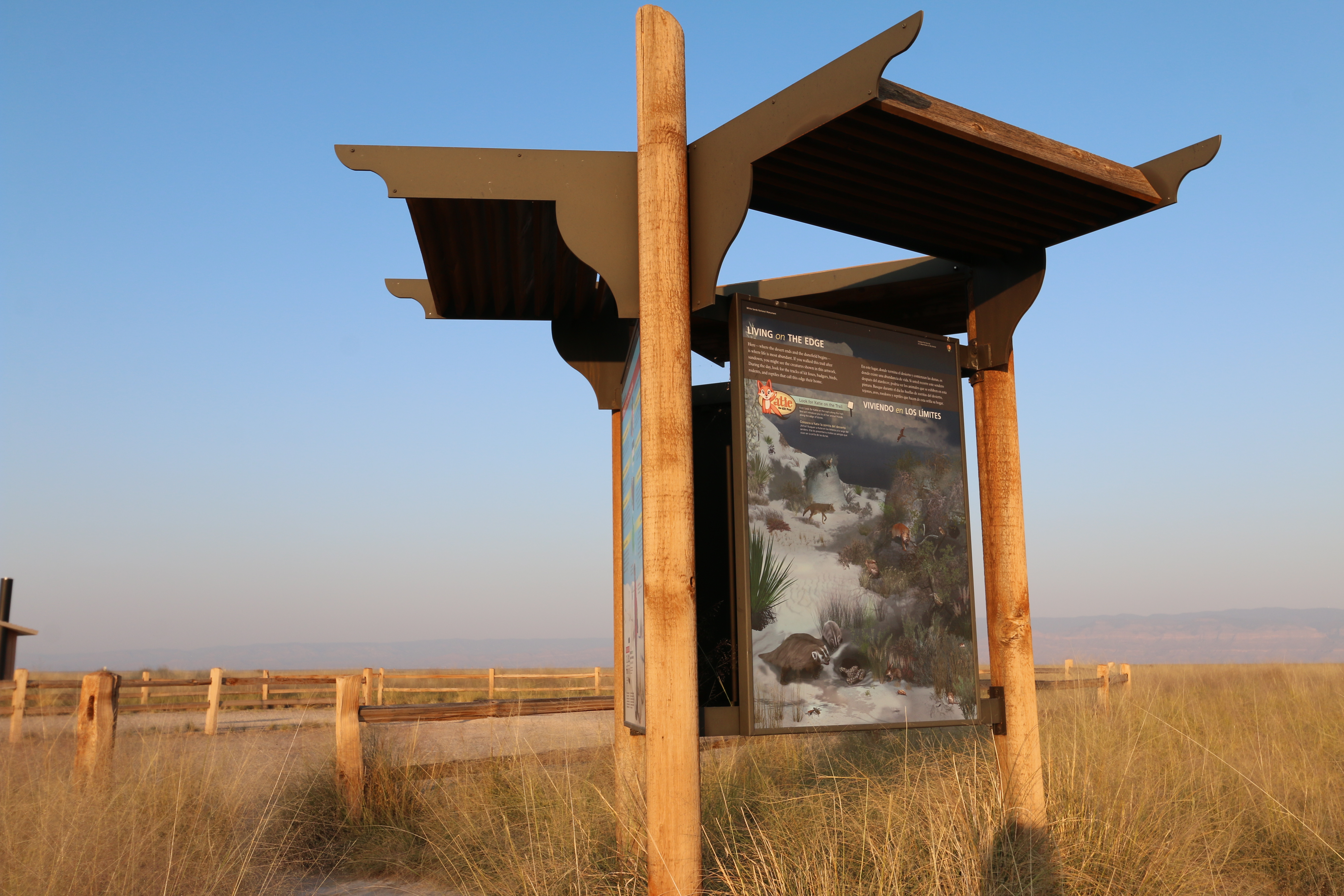
This three-foot by four-foot sign hangs on one side of a three-sided kiosk at the start of the Dune Life Nature Trail. The background of the panel is an illustration of the dunes at night with a variety of wildlife. Creatures identified include foxes, a lynx, rabbits, badgers, different kinds of mice, a rattlesnake, beetles, a wasp, and several kinds of birds, including an owl. At the top is text in both English and Spanish, which reads, “Living on the Edge. Here—where the desert ends and the dunefield begins—is where life is most abundant. If you walked this trail after sundown, you might see the creatures shown in this artwork. During the day, look for the tracks of kit foxes, badgers, birds, rodents, and reptiles that call this edge their home.” Below the text is a cartoon image of a red fox with long black eyelashes. Her left paw is raised and her long tail swoops to her left side, together forming the initial “K” in “Katie the Kit Fox.” Text to the right of the figure reads. “Look for Katie on the Trail. Kids! Look for Katie on the signs along the trail. She will introduce you to all her animal friends along the edge of the dunes.”
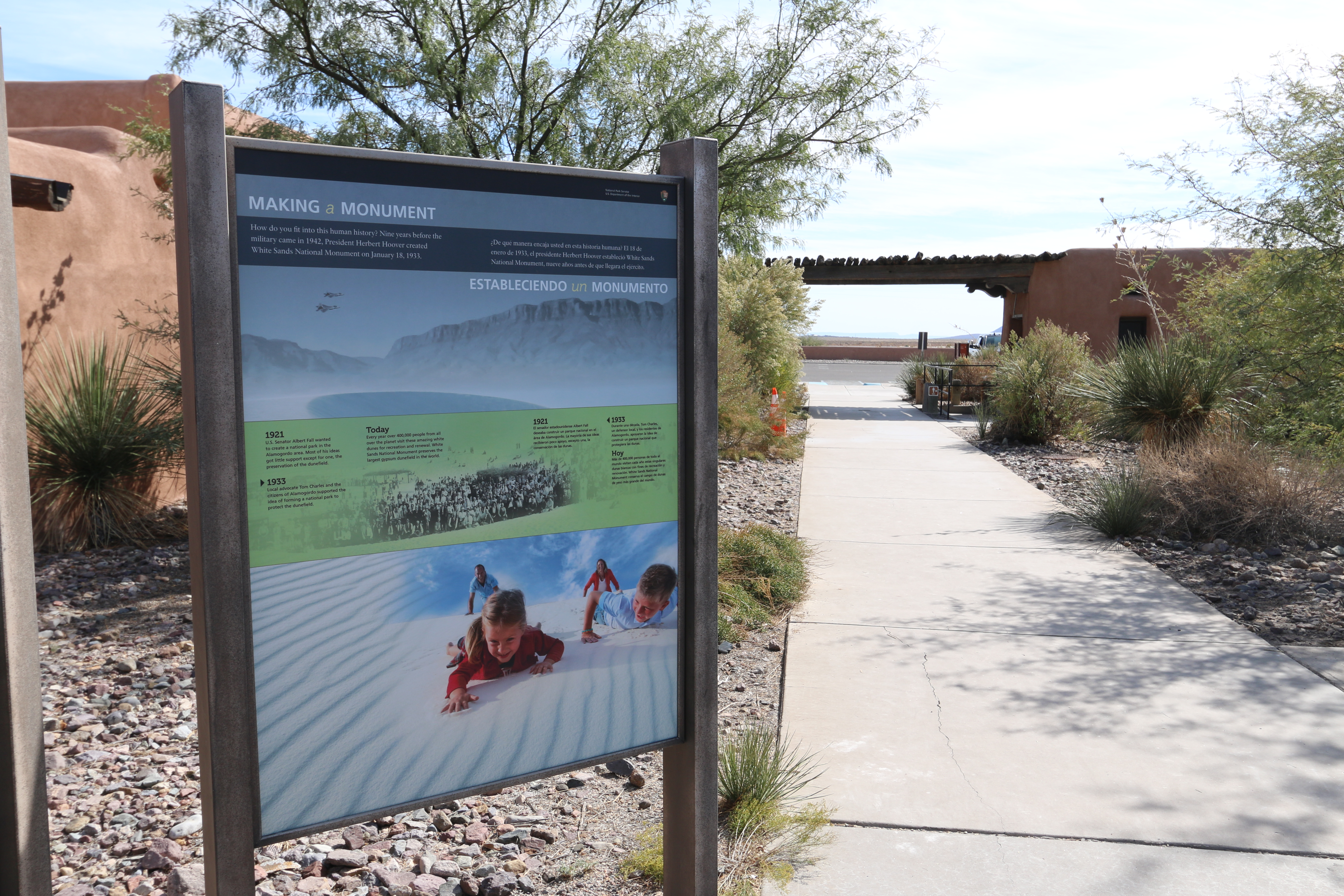
The "Making a Monument" interpretive sign is one of several informational exhibits located at the Visitor Center complex of White Sands National Park.
This 3-foot by 4-foot sign is the rightmost in a group of three standing along the side of the Visitor Center. The background of the panel features a photograph of the white sand dunes with the mountains visible behind. At lower right two small children, a girl and a boy, are sliding down a dune on their bellies, big grins on their faces, while their parents watch from the top of the slope. At the top is text is both English and Spanish that reads, “How do you fit into this human history? Nine years before the military came in 1942, President Herbert Hoover created White Sands National Monument on January 18, 1933.” Across the center of the panel is a green band with a black and white photograph of a large group of people, all posed at the bottom of a dune slope, facing us. Text on the band reads, “1921 – U.S. Senator Albert Fall wanted to create a national park in the Alamogordo area. Most of his ideas got little support except for one, the preservation of the dunefield. 1933 – Local advocate Tom Charles and the citizens of Alamogordo supported the idea of forming a national park to protect the dunefield. Today – Every year over 400,000 people from all over the planet visit these amazing white dunes for recreation and renewal. White Sands National Monument preserves the largest gypsum dunefield in the world.”
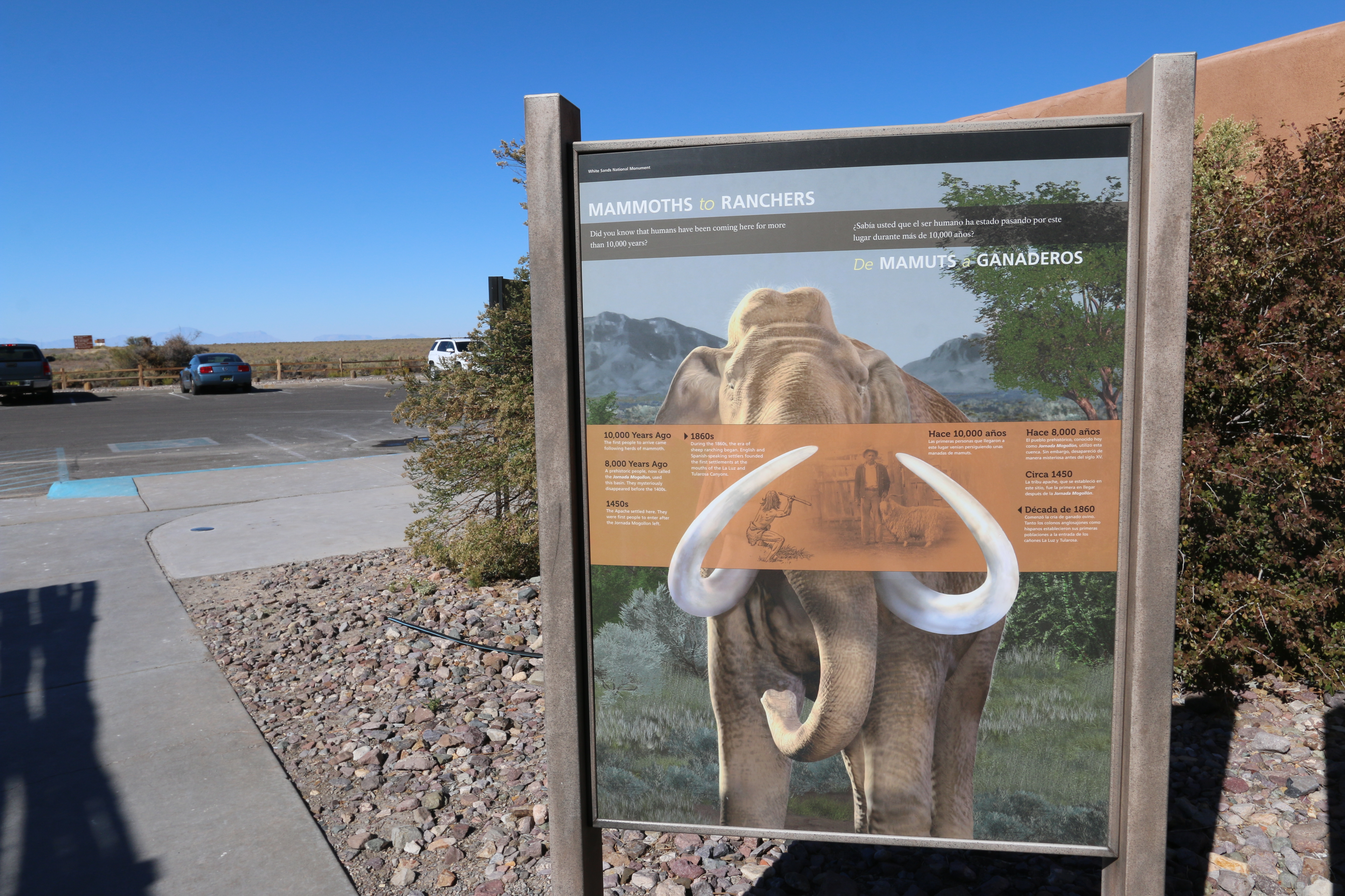
The "Mammoths to Ranchers" interpretive sign highlights the last ten millennia of human interaction with the Tularosa Basin.
This 3-foot by 4-foot sign is the leftmost in a group of three standing along the side of the Visitor Center. The background of the panel features an artist’s rendition of a mammoth, huge and elephant-like with long white tusks that curve up in wide loops back towards tis trunk. A tan band crosses the panel behind the tusks with two images on it. The one on the left shows a drawing of a pre-historic man with shaggy hair, dressed only in a loin cloth. He faces away from us, in a low crouch with spear raised ready to throw. To the right of that is a black and white photograph of a man wearing a loose jacket and hat standing next to a wooly sheep with long horns. Text on the panel is in both English and Spanish. At top it reads, “Did you know that humans have been coming here for more than 10,000 years?” On the tan band are milestones in time that read, “10,000 Years Ago. The first people to arrive came following herds of mammoth. 8,000 Years Ago. A prehistoric people, now called the Jornada Mogollon, used this basin. They mysteriously disappeared before the 1400s. 1450s – The Apache settled here. They were first people to enter after the Jornada Mogollon left. 1860s – During the 1860s, the era of sheep ranching began. English and Spanish-speaking settlers founded the first settlements at the mouths of the La Luz and Tularosa Canyons.”
This is one of several family-friendly interpretive exhibits along the Dune Life Nature Trail at White Sands National Park.
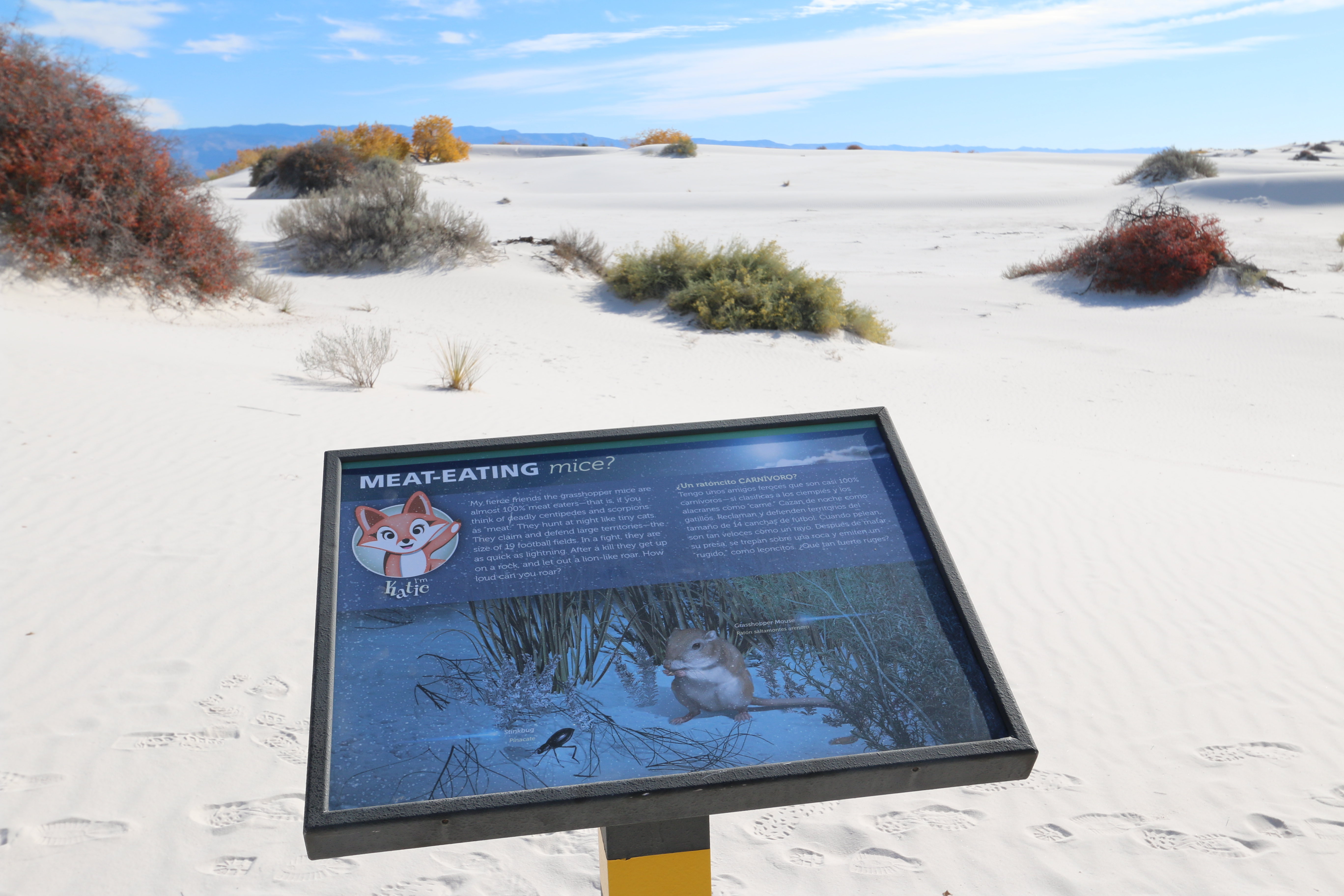
This sign, about two feet wide and one and one-half feet high, is mounted at an angle on a single metal post. The trail slopes down the dune past the sign and the next marker is clearly visible. On either side and behind you, the white sand stretches over the rolling dunes. Clumps of low bushes are scattered about. The sign has a picture of Katie, the cartoon fox figure, in the upper left, with text in both English and Spanish along the top. The bottom part of the sign has a picture of a Grasshopper Mouse, sitting back on its haunches, front paws held up to its mouth. It has a brown back and head, with lighter tan on its belly and front legs. Near the mouse is a shiny black stinkbug. Text at the top reads, “My fierce friends the grasshopper mice are almost 100% meat eaters—that is, if you think of deadly centipedes and scorpions as “meat.” They hunt at night like tiny cats. They claim and defend large territories—the size of 19 football fields. In a fight, they are as quick as lightning. After a kill, they get up on a rock, and let out a lion-like roar. How loud can you roar?”
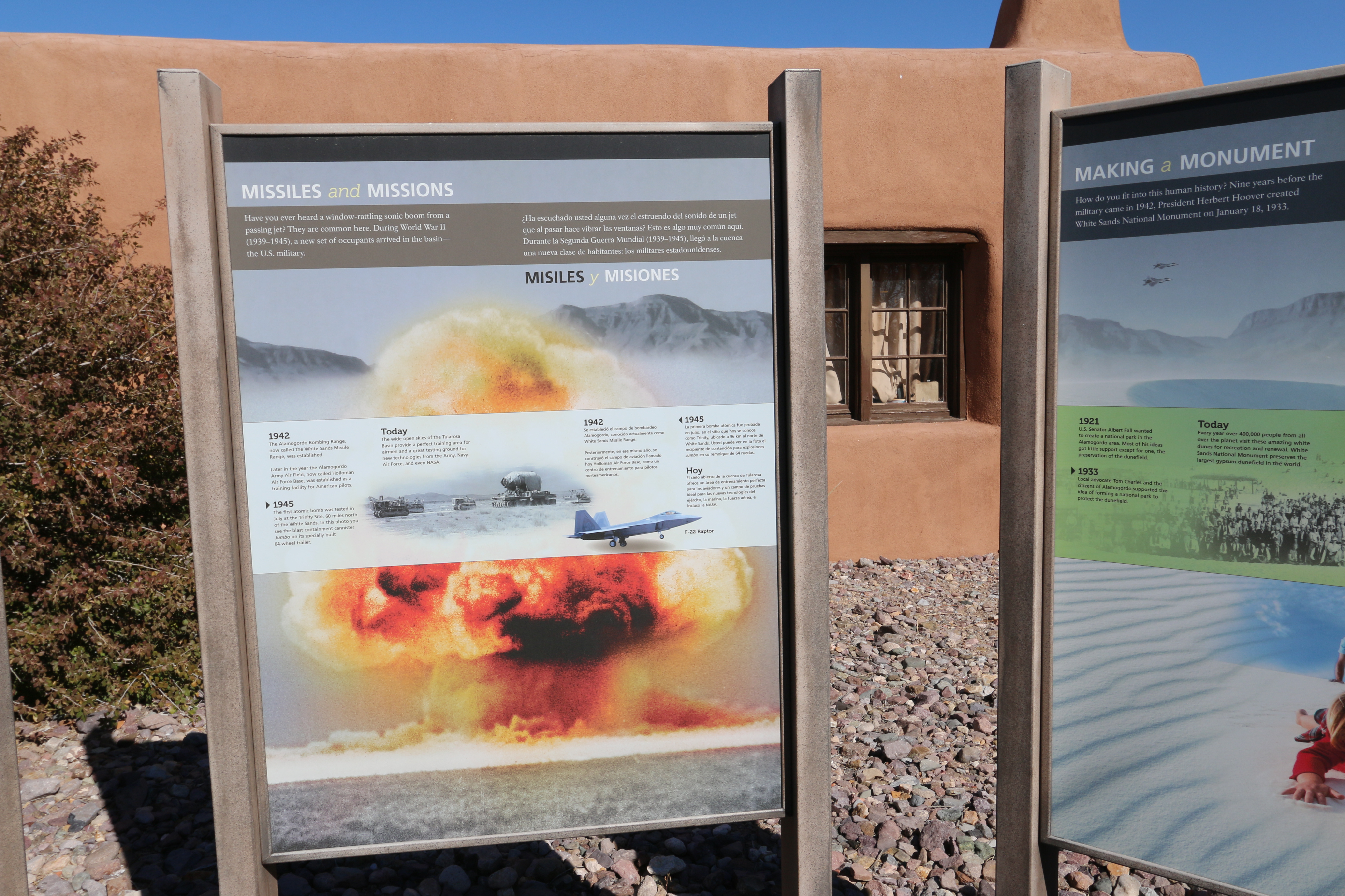
The "Missiles and Missions" interpretive sign describes the unique partnership between US Military and White Sands National Park.
This 3-foot by 4-foot sign is the center in a group of three standing along the side of the Visitor Center. The background of the panel features a photograph of a huge mushroom-shaped cloud rising from the desert floor, tinted with shades of red and yellow. At the top is text is both English and Spanish that reads, “Have you ever heard a window-rattling sonic boom from a passing jet? They are common here. During World War II (1939–1945), a new set of occupants arrived in the basin— the U.S. military.” A white band across the center of the panel has two pictures, one of an F-22 Raptor fighter jet and the other showing a line of heavy military equipment moving across the desert, most of them tractor-like, one of them a huge flat-bed on wheels with a cylindrical structure lying on top of it. Text on the band reads, “1942 – The Alamogordo Bombing Range, now called the White Sands Missile Range, was established. Later in the year the Alamogordo Army Air Field, now called Holloman Air Force Base, was established as a training facility for American pilots. 1945 – The first atomic bomb was tested in July at the Trinity Site, 60 miles north of the White Sands. In this photo you see the blast containment canister Jumbo on its specially built 64-wheel trailer. Today – The wide-open skies of the Tularosa Basin provide a perfect training area for airmen and a great testing ground for new technologies from the Army, Navy, Air Force, and even NASA.”
This is one of many interpretive exhibits on the Dune Life Nature Trail at White Sands National Park.
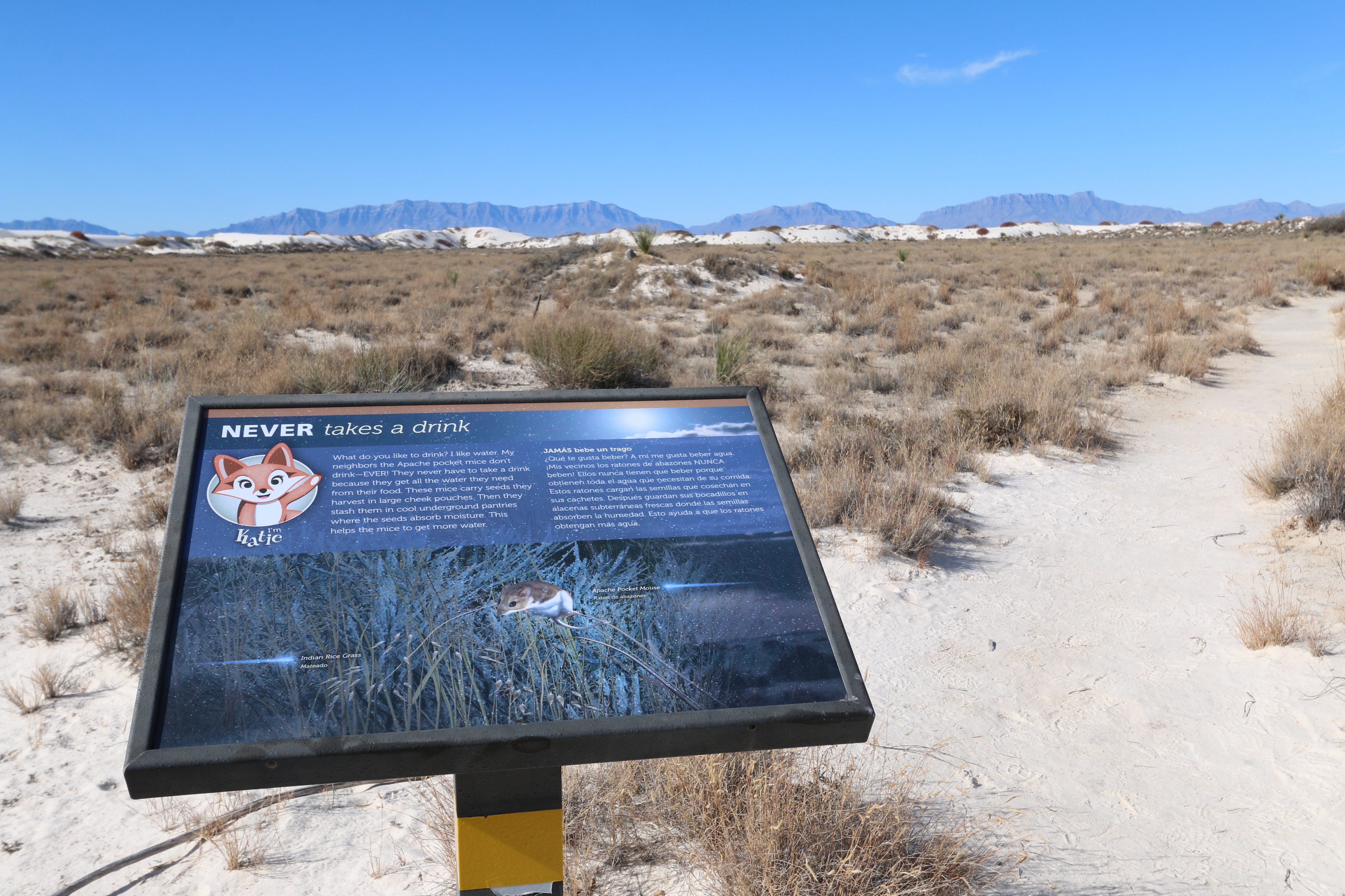
This sign, about two feet wide and one and one-half feet high, is mounted at an angle on a single metal post. Past the sign as you face it, the hard-packed trail continues across a flat basin surrounded by low dunes. The basin floor ahead and on either side of you is covered with grasses, a few small scrubs and here and there a yucca plant with its sword-like leaves. Behind you the trail makes a gradual climb up to a low ridge. The sign has a picture of Katie, the cartoon fox figure, in the upper left, with text in both English and Spanish along the top. The bottom part of the sign has a picture of an Apache Pocket Mouse with its brown back and white belly and legs. The mouse clings to a slender stalk of Indian Rice Grass, which bends due to its weight. Text at the top reads, “What do you like to drink? I like water. My neighbors the Apache pocket mice don’t drink—EVER! They never have to take a drink because they get all the water they need from their food. These mice carry seeds they harvest in large cheek pouches. Then they stash them in cool underground pantries where the seeds absorb moisture. This helps the mice to get more water.”
This is one of many family-friendly interpretive exhibits on Dune Life Nature Trail at White Sands National Park.
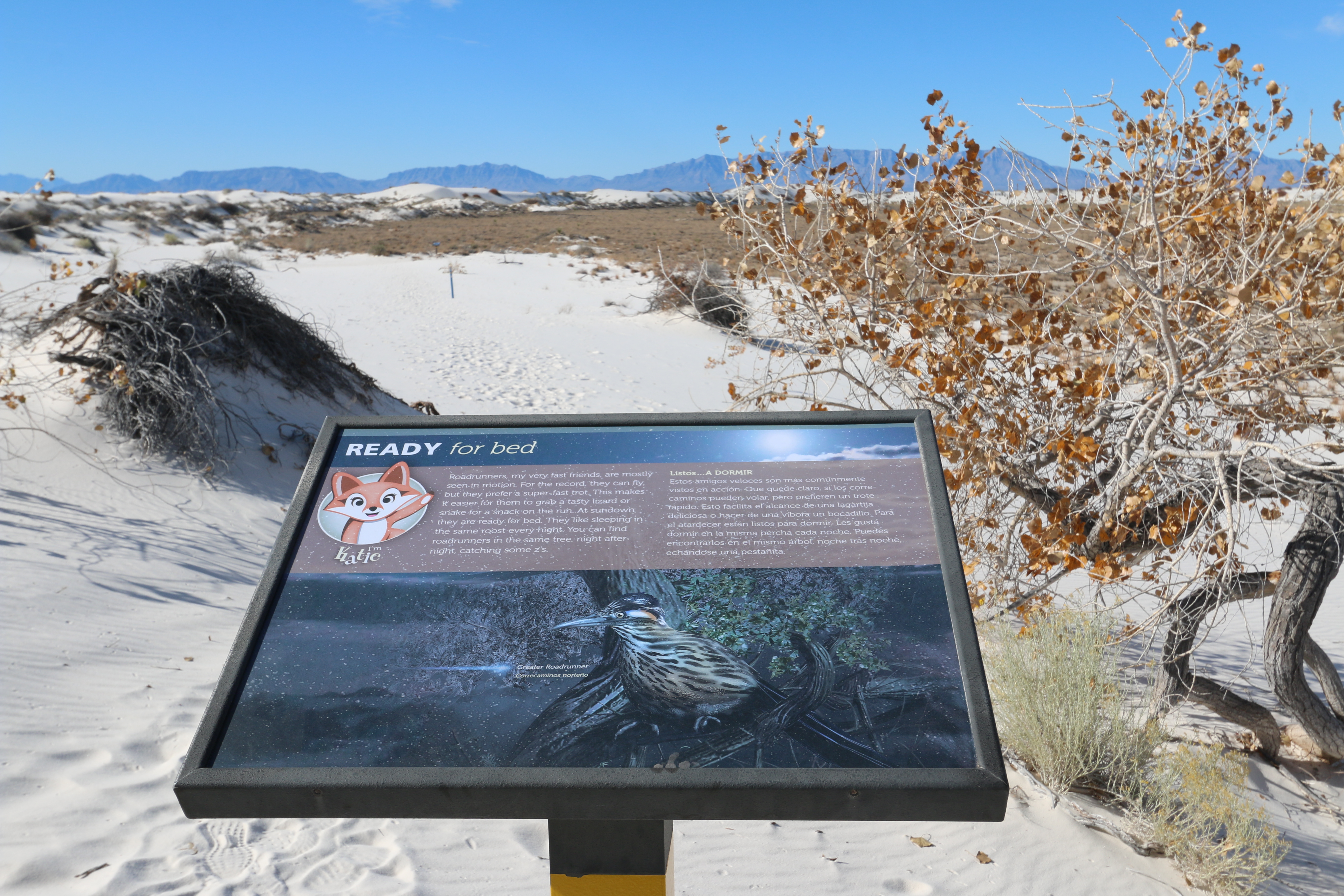
This sign, about two feet wide and one and one-half feet high, is mounted at an angle on a single metal post. Past the sign as you face it, the trail continues slightly downslope as it descends from the ridge on your left to a brush-covered flat basin surrounded by a line of dunes. To the right, just past a few bush-like cottonwood trees, the flat white sand behind you changes to scrubby vegetation. To the left, the sand rises to the top of a low dune ridge. The sign has a picture of Katie, the cartoon fox figure, in the upper left, with text in both English and Spanish along the top. The bottom part of the sign has a picture of a Greater Roadrunner perched on a gnarled branch. The bird has a tan body marked with short black stripes. It has a black cap, white beneath and behind its eyes with occasional patches of red or blue.. Its bill is as long as its head and very pointed. Text at the top reads, “Roadrunners, my very fast friends, are mostly seen in motion. For the record, they can fly, but they prefer a super-fast trot. This makes it easier for them to grab a tasty lizard or snake for a snack on the run. At sundown they are ready for bed. They like sleeping in the same roost every night. You can find roadrunners in the same tree, night after night, catching some z’s.”
This is one of several family-friendly interpretive exhibits on Dune Life Nature Trail at White Sands National Park.
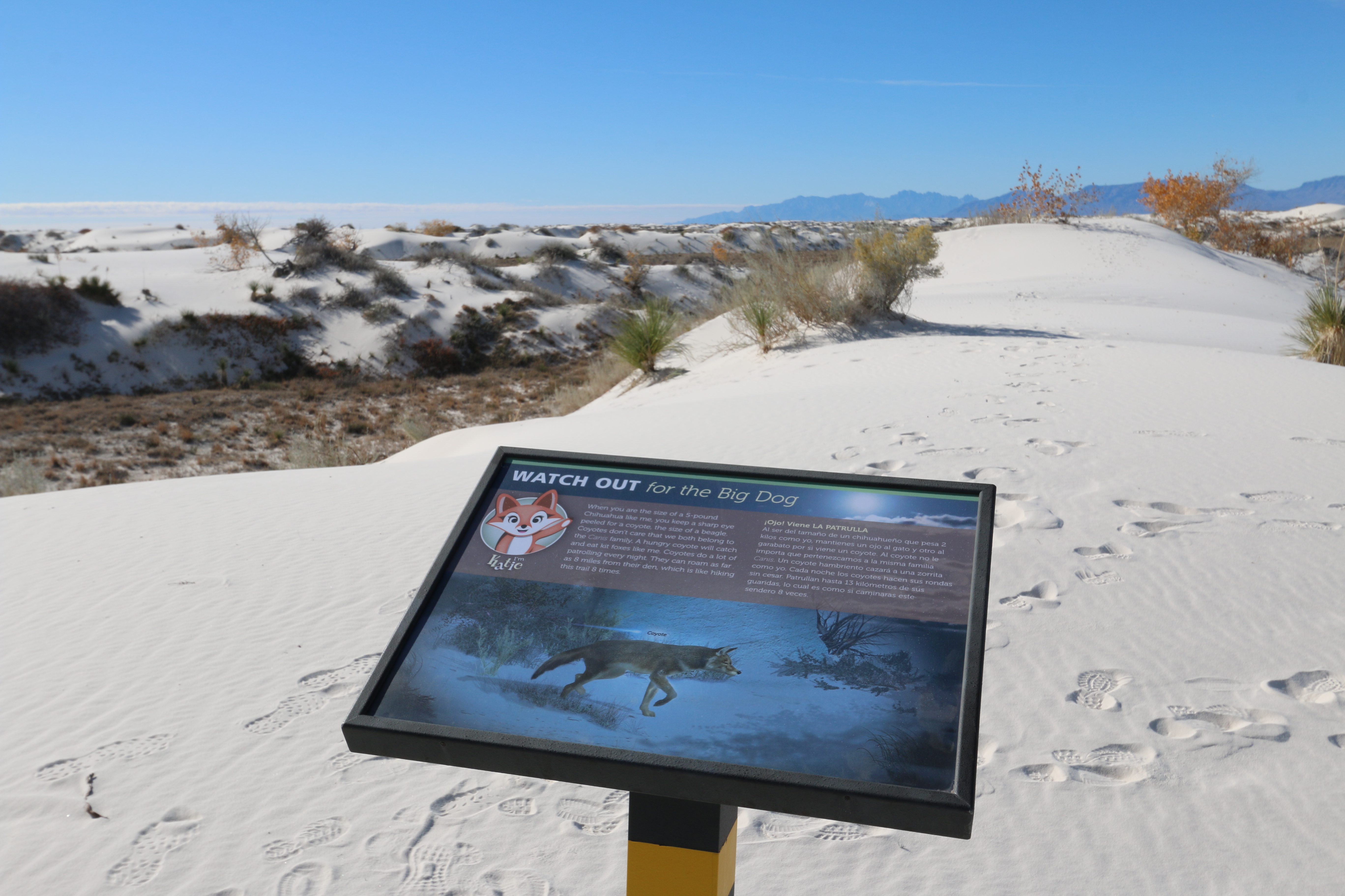
This sign, about two feet wide and one and one-half feet high, is mounted at an angle on a single metal post. It is mounted on top of a small dune ridge that the trail is following. To the right is a shallow, flat-bottomed sand basin. A few yards to the left, the side of the dune ridge falls off very steeply to a flat, brush-covered area about 30 feet below. The sign has a picture of Katie, the cartoon fox figure, in the upper left, with text in both English and Spanish along the top. The bottom part of the sign has a picture of a coyote. He stands, facing right, his right foreleg raised as he stares intently ahead. He has fur that is brown with black tips, a white underbelly and a bushy tail. Text at the top reads, “When you are the size of a five-pound Chihuahua like me, you keep a sharp eye peeled for a coyote, the size of a beagle. Coyotes don’t care that we both belong to the Canis family. A hungry coyote will catch and eat kit foxes like me. Coyotes do a lot of patrolling every night. They can roam as far as eight miles from their den, which is like hiking this trail eight times.”
This is one of several interpretive exhibits on the Playa Trail at White Sands National Park.
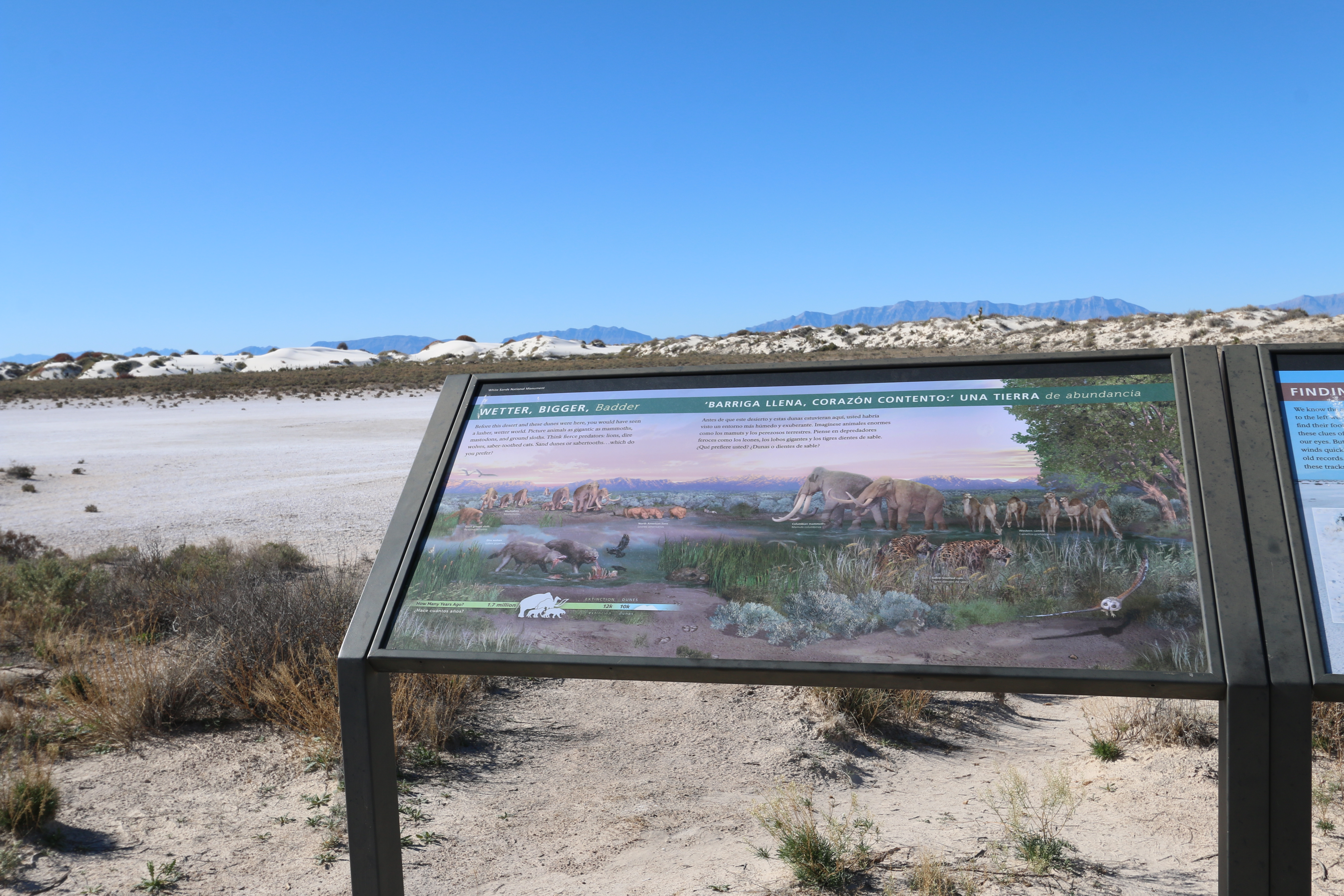
This 4-foot by 2-foot sign stands in a metal frame near the edge of the playa at the end of the trail. As you face the sign, a low ridge of dunes borders the far side of eth playa and the brush covered flat desert is behind you. The background of the sign shows an illustration of flat, brush-covered land with steep mountains along the horizon. Pictures of prehistoric animals dot the landscape. At upper left, there is a herd of mastodons, elephant-like with long white tusks. To the left of them is a giant ground sloth, with a long, thick tail. At bottom left are two dire wolves. They stand in shallow water near some cattails, feeding on a carcass, black raven-like birds hovering nearby. In the center is a group of three North American lions, crouched at water’s edge, drinking. At the right side of the picture are two huge Columbian mammoths next to a herd of 6 western camels with single humps. At lower right, two sabre-tooth cats look on, their fur dappled like a leopard, their long canine teeth hanging past their chins. At lower left, a timeline asks, “How many years ago?” It shows silhouettes of the animals at 1.7 million years, then extinction at 12 thousand years agao. The duens appear at 10 thousand years. At the top is text in both English and Spanish, which reads, “Before this desert and these dunes were here, you would have seen a lusher, wetter world. Picture animals as gigantic as mammoths, mastodons, and ground sloths. Think fierce predators: lions, dire wolves, saber-toothed cats. Sand dunes or sabertooths…which do you prefer?”
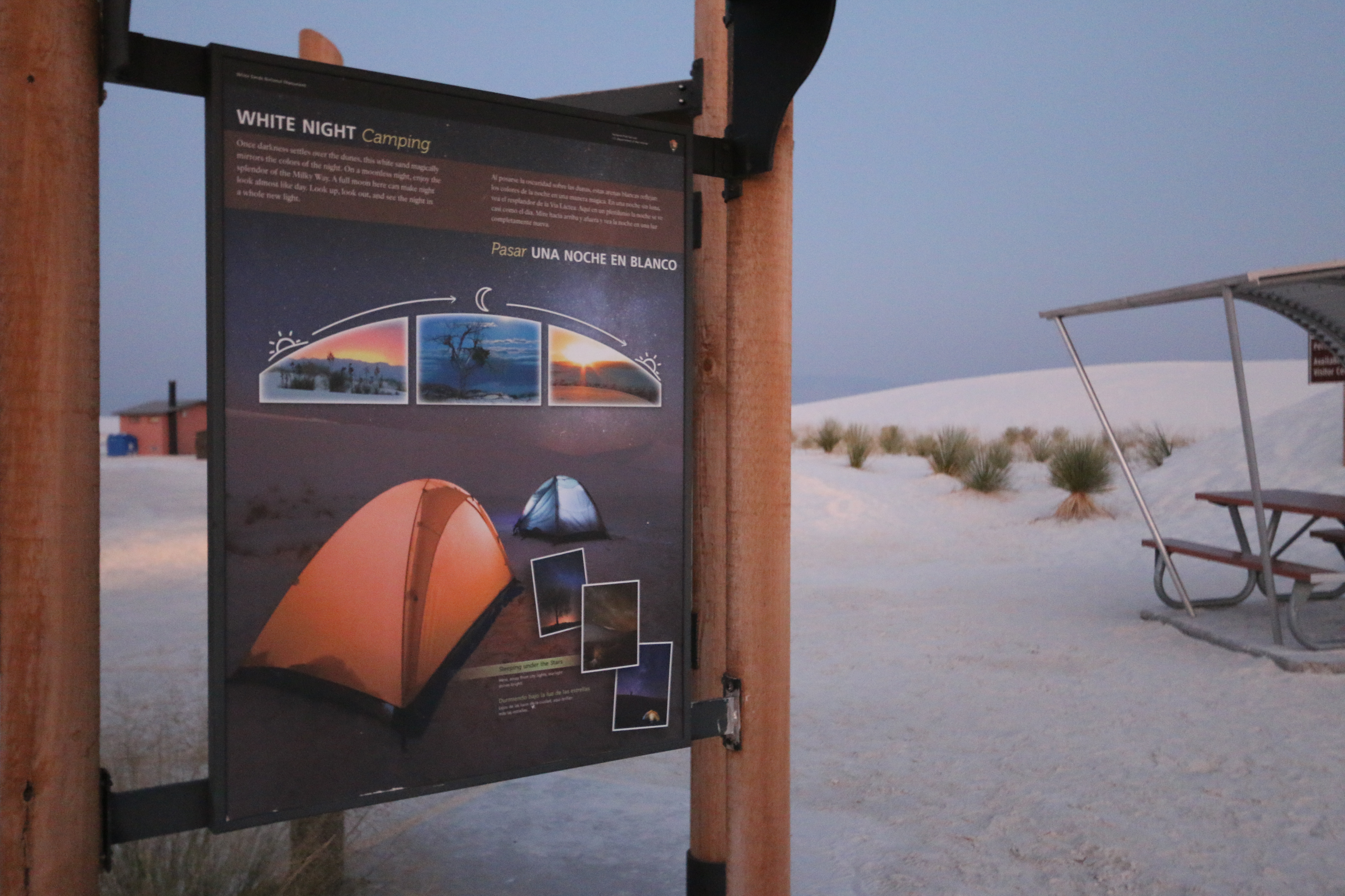
This kiosk panel describes backcountry camping at White Sands National Park.
This three foot by four foot sign hangs on one side of the kiosk at the start of the trail. The background of the panel shows a photograph of the dunes at night, a heavy sprinkling of stars across the sky. In the foreground are two tents, glowing from lights inside. Three small photographs are in the bottom right corner showing different views of the night sky with lots of stars and the Milky Way forming bright clouds. The caption reads, “Sleeping Under the Stars. Here, away from city lights, starlight shines bright.” At the top is text in both English and Spanish, which reads, “Once darkness settles over the dunes, this white sand magically mirrors the colors of the night. On a moonless night, enjoy the splendor of the Milky Way. A full moon here can make night look almost like day. Look up, look out, and see the night in a whole new light.” Across the middle of the panel are three photographs. The one on the left shows a sunset, the sky glowing yellow and orange over the mountain peaks. The middle picture shows a scene under a bright moon, the white dunes aglow under the scattered clouds, one lone tree at the left. The final picture shows a sunrise, bright over the far mountains, giving the rippled sand a golden glow.
This is one of several interpretive signs found at Dune Life Nature Trail.
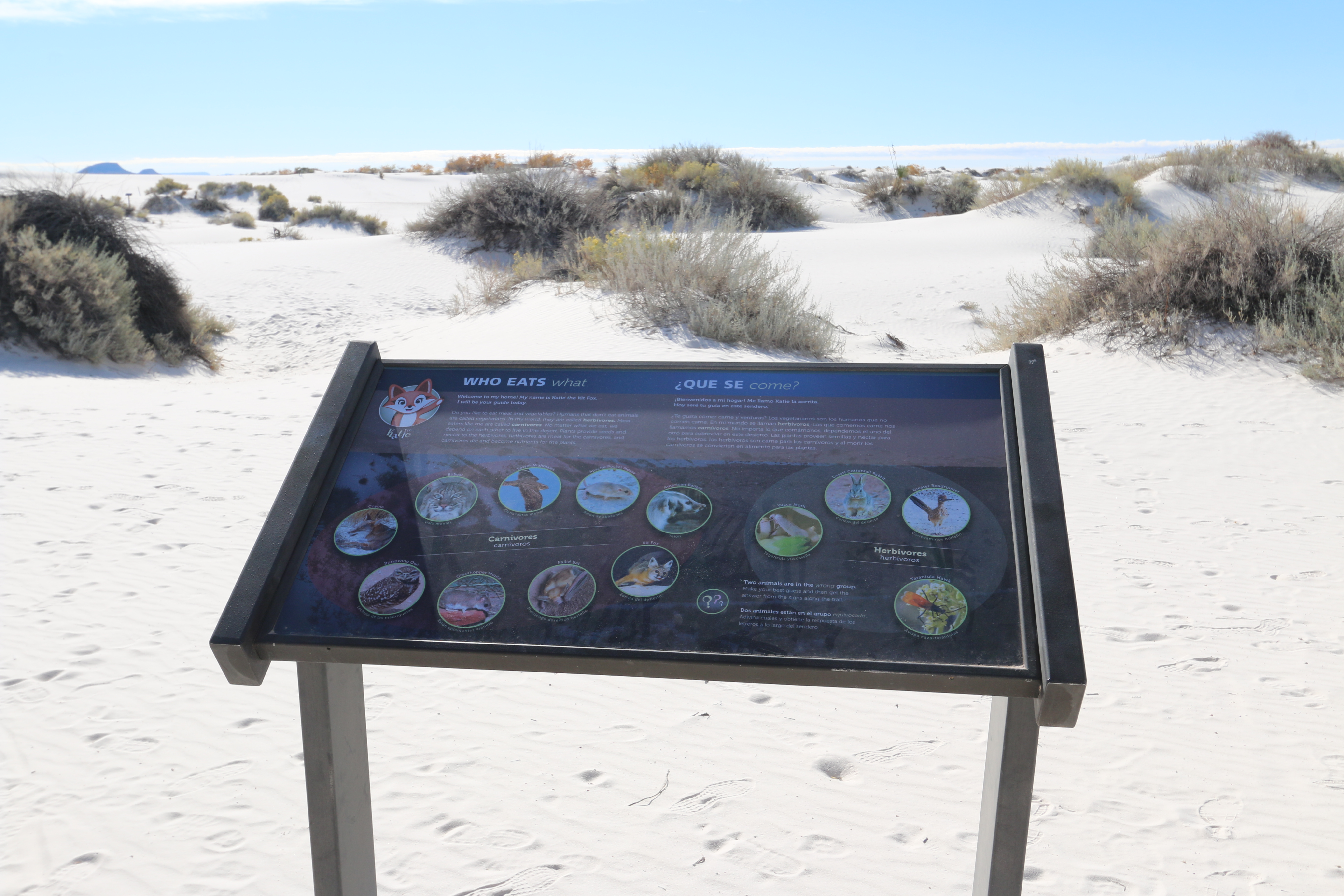
This sign, about three and a half feet wide andtwo feet high, is mounted at an angle in a metal frame on two metal posts. Behind the sign the white sand slopes up slightly with grey-green bushes dotting the rolling surface. Immediately past the sign is a blue trail marker. More markers are visible to the right and to the left. Behind you, as you face the sign, are sand pedestals on each side of the path. These outcroppings of solid sand are about 12 feet high, topped with thick vegetation. Their vertical surfaces are made of hardened sand with many cracks and uneven places where chunks of sand have fallen off, looking like miniature cliff faces. The sign has a picture of Katie, the cartoon fox figure, in the upper left, with text in both English and Spanish along the top. The bottom part of the sign has two groups of small round photographs of animals.Nine images arranged in an oval on the left side are identified as carnivores, and four in a circle on the right are labeled as herbivores. From the far left and moving clockwise, the animal pictures listed as carnivores are the Coyote, the Bobcat, the Lesser Nighthawk, the Apache Pocket Mouse, the American Badger, the Kit Fox, the Pallid Bat, the Grasshopper Mouse, and the Burrowing Owl. In the herbivores circle, starting at left and moving clockwise are the Yucca Moth, the Desert Cottontail Rabbit, the Greater Roadrunner and the Tarantula Hawk, which is a black insect with thin orange-colored wings. Text at the top reads, “Welcome to my home! My name is Katie the Kit Fox. I will be your guide today. Do you like to eat meat and vegetables? Humans that don’t eat animals are called vegetarians. In my world, they are called herbivores. Meat eaters like me are called carnivores. No matter what we eat, we depend on each other to live in this desert. Plants provide seeds and nectar to the herbivores, herbivores are meat for the carnivores, and carnivores die and become nutrients for the plants.” More text at the bottom reads, “Two animals are in the wrong group. Make your best guess and then get the answer from the signs along the trail.”
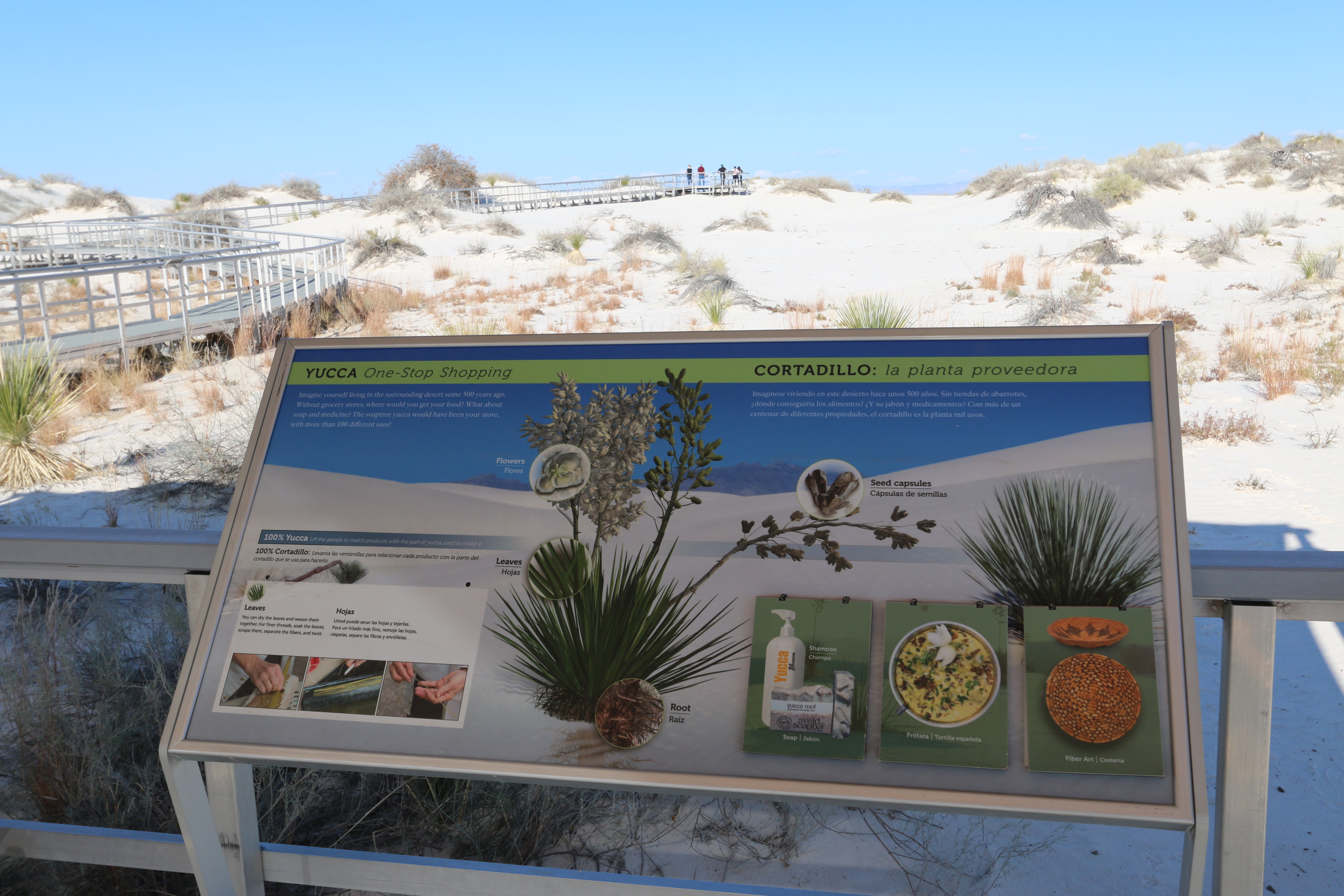
This interpretive sign is one of many interactive exhibits found on the Interdune Boardwalk at White Sands National Park.
This 4-foot by 2-foot sign is mounted on the railing under the tent shelter along the boardwalk. The background shows a view of white dunes with mountain peaks rising in the distance. In the middle of the panel is a large picture of a yucca plant. Its base is a mound of long, sword-like leaves. Four stalks rise up out of the mound, over twice as long as the leaves. The two on the left are covered with clusters of white blossoms. A single flower is enlarged, to show it white cupped petals surrounding a center with white stamen and pistil. The third stalk is full of green seed capsules, long ovals in shape. The last stalk shows the capsules dried and brown. An enlargement shows the capsules splitting open to expose the seeds. A final enlargement at the bottom of the plant shows the fibrous roots. At the top is text in both English and Spanish, which reads, “Imagine yourself living in the surrounding desert some 500 years ago. Without grocery stores, where would you get your food? What about soap and medicine? The soaptree yucca would have been your store, with more than 100 different uses! 100% Yucca – Lift the panels to match products with the part of yucca used to make it.” At bottom left is a rectangular flap with pictures of a basket, a yarn-like apron and woven, flat sandals. Under the flap text reads, “Leaves – You can dry the leaves and weave them together. For finer threads, soak the leaves, scrape them, separate the fibers, and twist.” Photographs show hands scraping a leaf, then separating fiber-like pieces from it. At lower right are three smaller panels. The one on the left has a picture of a plastic bottle with a pump and two bars of soap. Lifting the flap reveals text that reads, “Roots, leaves – Peel and puree the root then dry. Scrape the leaf, mix with water, then strain the scrapings.” The middle panel has a picture of a frittata, creamy yellow in color with a yucca blossom for garnish. Under the flap text reads, “Flowers – Cook the petals with your favorite egg dish, or add them to hearty stews of beef, pork, or chicken.” The last panel has a picture of two woven bowls with intricate diamond and zig-zag patterns. Under the flap text reads, “Seeds – Soak seeds in water to make a rich black dye.”
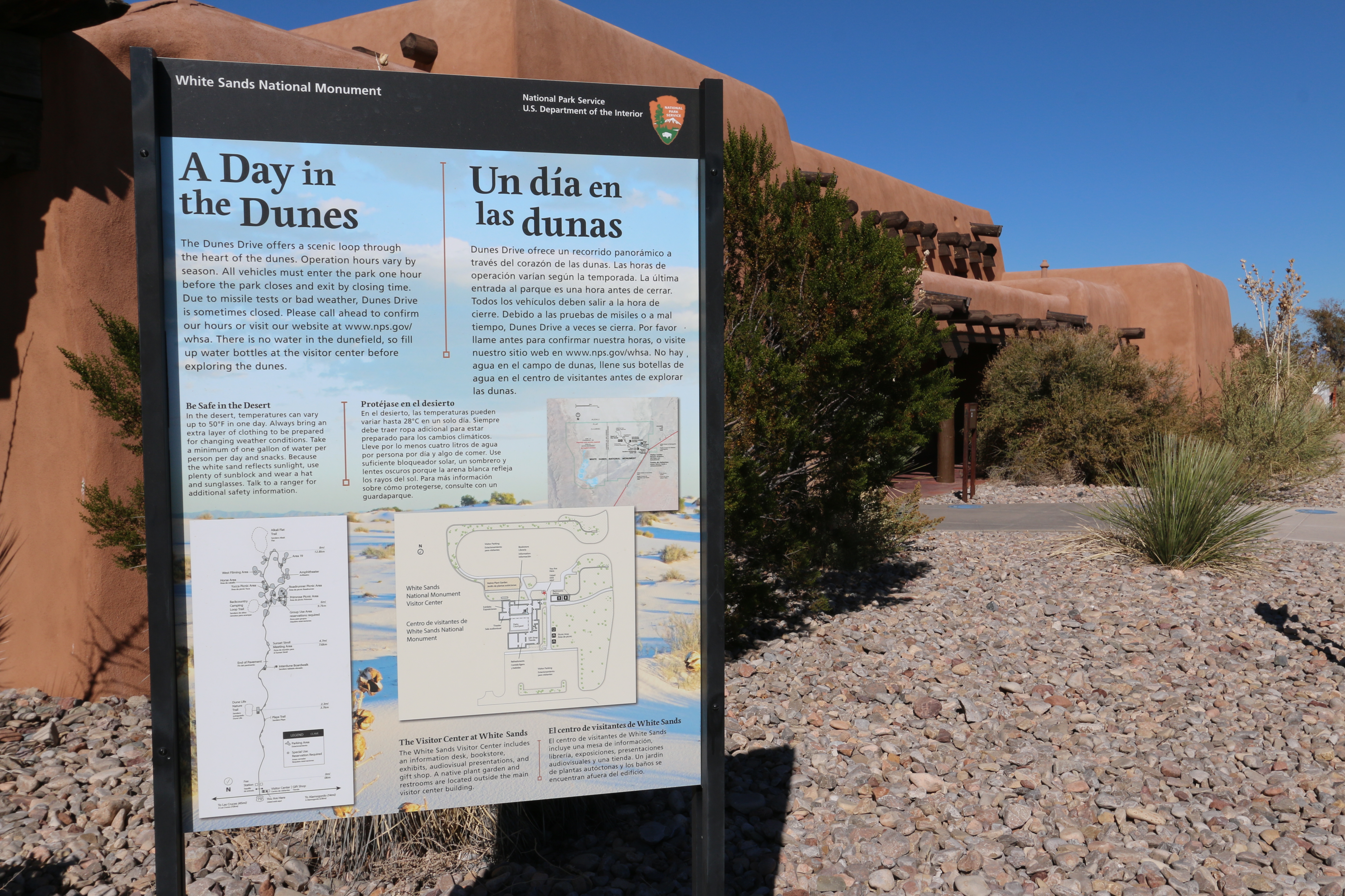
This interpretive sign offers an overview of White Sands National Park as a whole.
This sign hangs on the back side of a kiosk made of rough-hewn logs as posts and a small shade roof made of small branches. The background of the panel features a photograph of the white dunes dotted with a few clumps of grasses or bushes. At the bottom are three maps, one showing details along the drive into the dunes, one showing the layout of the visitor center buildings and parking areas and the final one showing the full park boundaries and the relative location of the entrance road and the visitor center. At the top is text in both English and Spanish that reads, “The Dunes Drive offers a scenic loop through the heart of the dunes. The monument opens every day at 7 am. From Memorial Day to Labor Day, the drive is open until 9 pm, and all cars must exit by 10 pm. The rest of the year, all vehicles must exit the park one hour after sunset. There is no water in the dunefield, so fill up water bottles at the visitor center before exploring the dunes. “Be Safe in the Desert. In the desert, temperatures can vary up to 50 degrees Fahrenheit in one day. Always bring as extra layer of clothing to be prepared for changing weather conditions. Take a minimum of one gallon of water per person per day and snacks. Because the white sun reflects sunlight, use plenty of sunblock and wear a hat and sunglasses. Talk to a ranger for additional safety information. “The White Sands Visitor Center includes an information desk. Bookstore, exhibits, audiovisual presentations and a gift shop. A native plant garden and restrooms are located outside the main visitor center building.” The map at lower left shows detail of the Dunes Drive of White Sands National Monument. The road begins at the bottom of the map where it turns off Highway 70. Las Cruces is 45 miles to the left and Alamogordo is 14 miles to the right. The visitor Center is just to the right of the road as it exits the highway. Just past the visitor center is a gate with the Fee Station located a little further on. At 2.3 miles along the road is the Dune Life Nature Trail on the left hand side. There is a parking area there and the trail loop is shown as a dotted line. Just below that trail is a small pullout on the right side of the road for the Playa Trail. At 4.1 miles on the right is a parking area for the Interdune Boardwalk and just past that location, the pavement ends and the road turns to hard-packed sand. At 4.7 miles is the Sunset Stroll Meeting Area. At 6 miles, the road splits to make a loop. There are many parking areas along this section of the road, indicated by grey. Going counter clockwise around the loop, there are two picnic areas on the right, the Primrose Picnic Area and the Roadrunner Picnic Area as well as a Group Use Area, which requires reservations. Near the far end of the loop is Area 19 and the Amphitheater. Once you round the end of the loop, there is a large parking area for the Alkalai Flat Trail. Beyond that, is an area labeled West Filming Area. As you approach the split in the road, there is the Yucca Picnic Area, and finally, very close to the split is parking for the Backcountry Camping Trail.
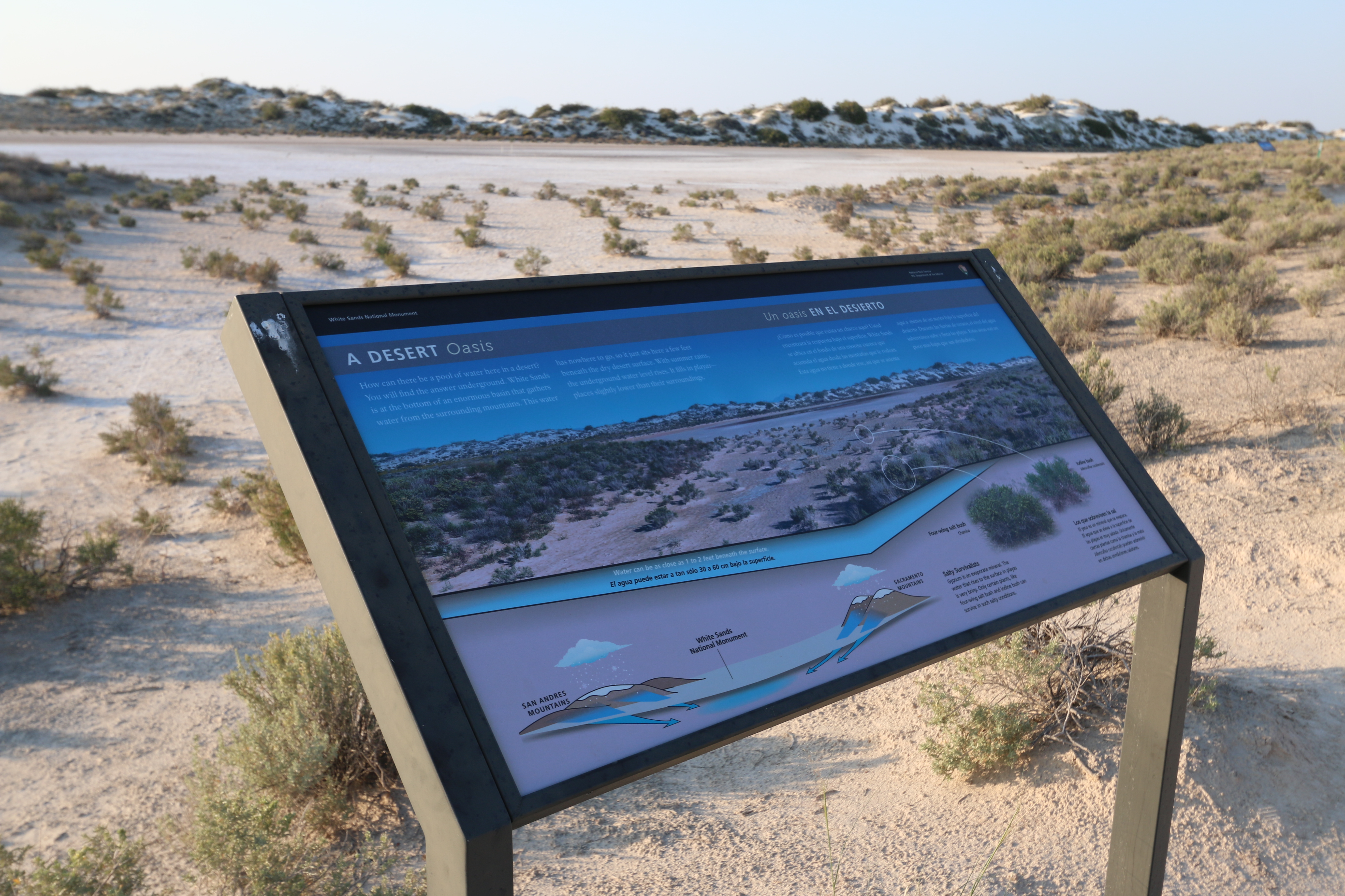
This is one of several interpretive signs along the Playa Trail at White Sands National Park.
This four foot by two foot sign stands in a metal frame near the southern edge of the playa. From the playa proper, a small low inlet extends towards us from the right and ends a short distance past the sign on the left. A small ridge of dunes lies on the far side of the playa, running back towards the road. Behind you as you face the sign, the desert prairie stretches back toward the entrance to the park. The background of the sign features a picture of the playa viewed from the position of the sign. The lower part of the picture is cut away, showing a blue band underneath. The label reads, “Water can be as close as one to two feet beneath the surface.” At bottom left of the panel is a sketch showing the San Andres Mountains to the west and the Sacramento Mountains to the east, with White Sands National Monument lying in the flat valley in between. Clouds over the mountains drop snow on the peaks. Blue arrows indicate melted runoff flowing off the mountain sides and pooling beneath White Sands. At the top is text in both English and Spanish, which reads, “How can there be a pool of water here in a desert? You will find the answer underground. White Sands is at the bottom of an enormous basin that gathers water from the surrounding mountains. This water has nowhere to go, so it just sits here a few feet beneath the dry desert surface. With summer rains, the underground water level rises. It fills in playas— places slightly lower than their surroundings.” At the bottom right of the panel are pictures of two different bushes with circles showing where the plants are located in the picture of the playa. The bush on the right is an Iodine Bush. The one on the left is a Four-wing Salt Bush. Text at the bottom reads, “Salty Survivalists. Gypsum is an evaporate mineral. The water that rises to the surface in playas is very briny. Only certain plants, like four-wing salt bush and iodine bush can survive in such salty conditions.”
Not far from the last informational sign on the right is a big Rio Grande cottonwood. The cottonwood has roots that have been exposed and has grown bark like the trunk to protect them. The leaves look like spades. Some smaller cottonwoods are coming up from the roots of the tree.
Sledding wasn't always the main attraction at White Sands. Continue on to see how the Monument's first superintendent brought a different kind of tourism into the dunefield.
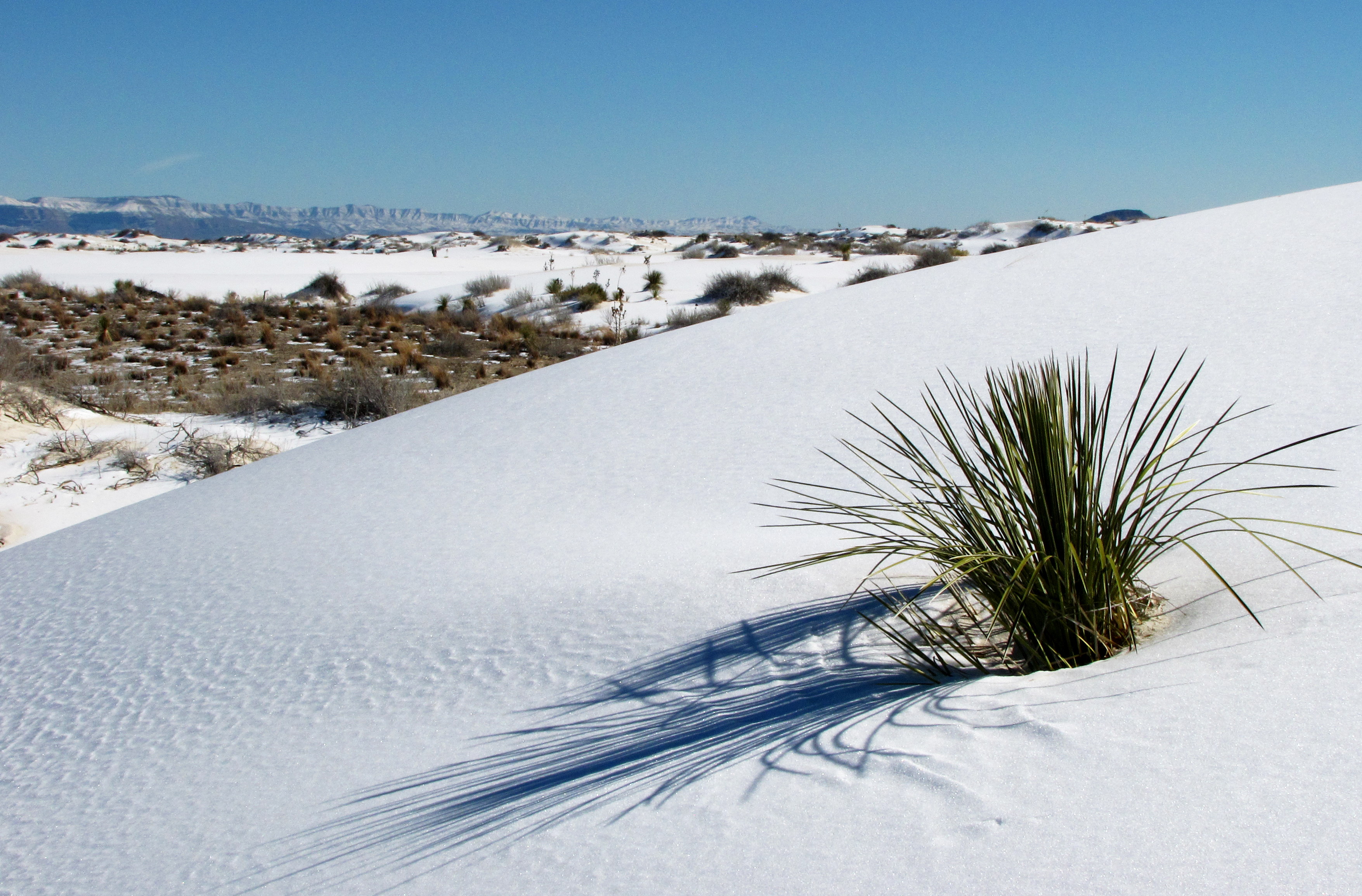
The visitor is surrounded by the white dunes rising and falling on all sides, with distant mountains visible both to the west and the east. The dunes are bare white sand, often with ripples across their surface. In between are small flat basins with some clumps of grass, small bushes and an occasional yucca plant. When peering out straight ahead of them, the visitor can see a large flat interdunal area. The ground here is hard-packed, firmer, and often slightly darker than the soft white sand found in the dunes themselves.
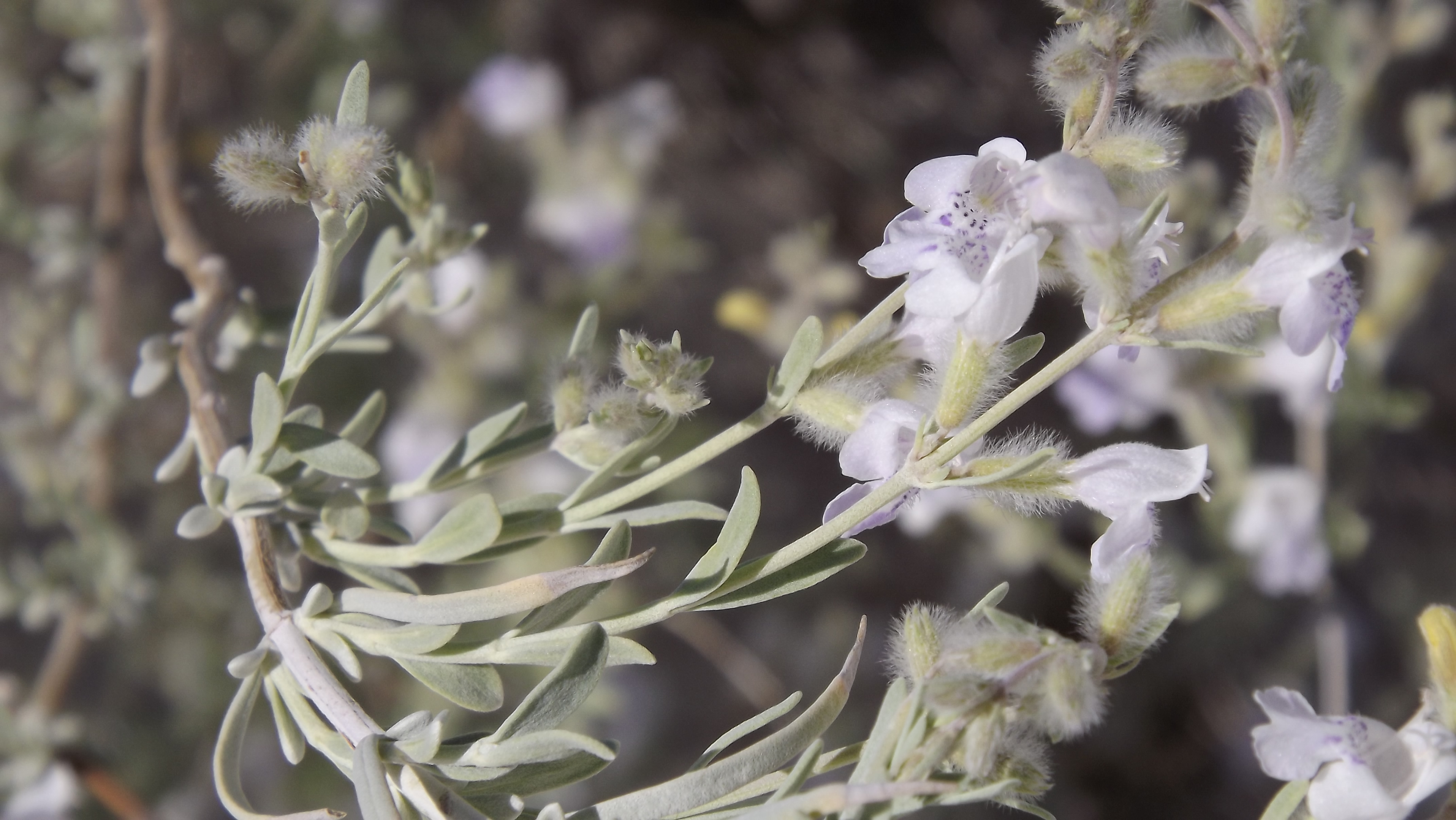
You are on top of a tall dune. On the left of the informational sign is a Skunkbush Sumac and behind you are Hoary Rosemary Mint bushes. To the right is the trail which leads down the dune.
If you'd been a visitor in the 1930s and 40s, your path into the park would have looked much different.
The visitor is surrounded by the white dunes rising and falling on all sides, with distant mountains visible both to the west and the east. The dunes are bare white sand, often with ripples across their surface. In between are small flat basins with some clumps of grass, small bushes and an occasional yucca plant. In this small basin in particular are many red pieces of clay, varying in sizes, in a line shaped like a road that rests above the surface of the interdune area. Small plants poke out of the clay, which is mixed in with white gypsum sand. The "road" is about four feet wide and extends around twenty feet long.
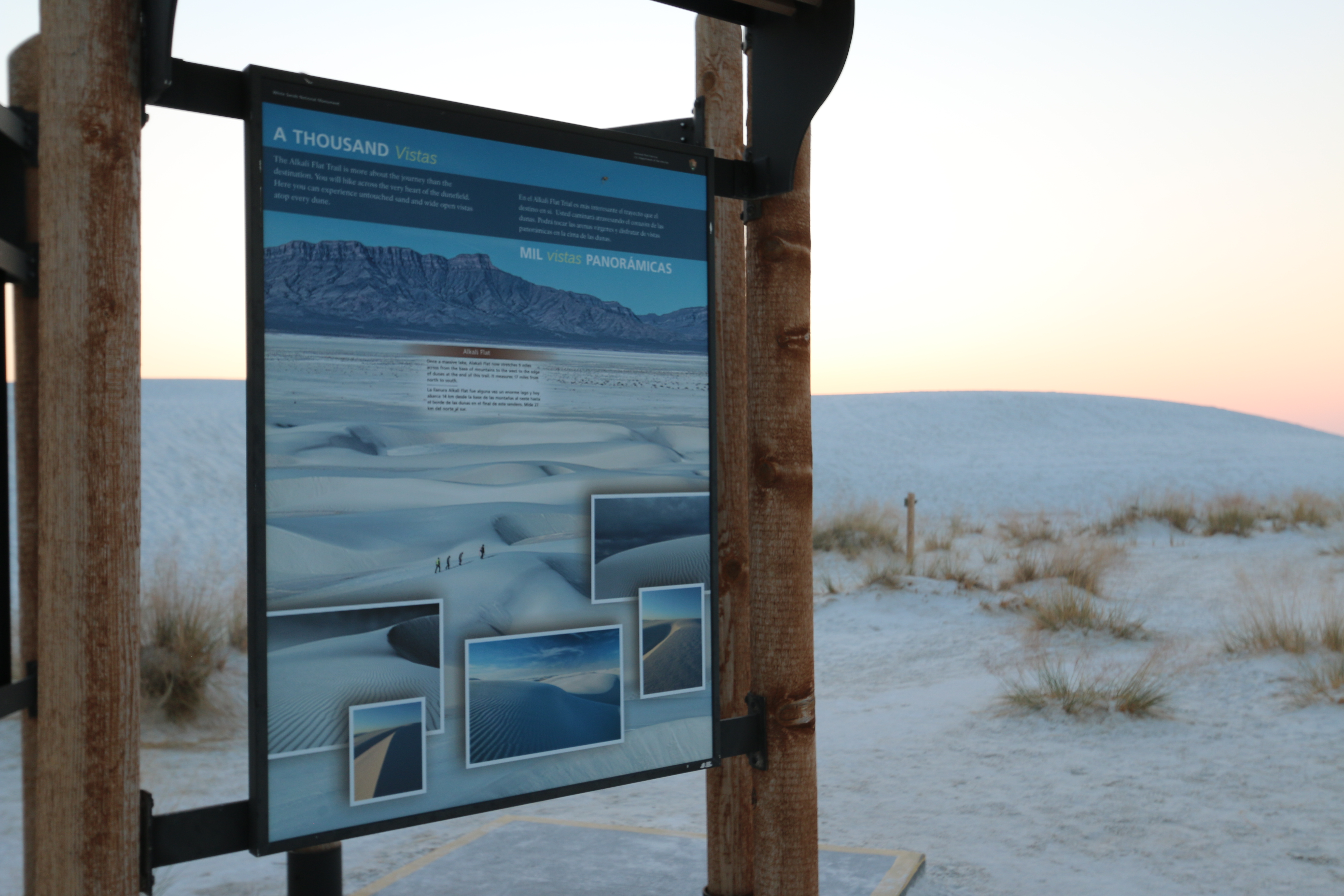
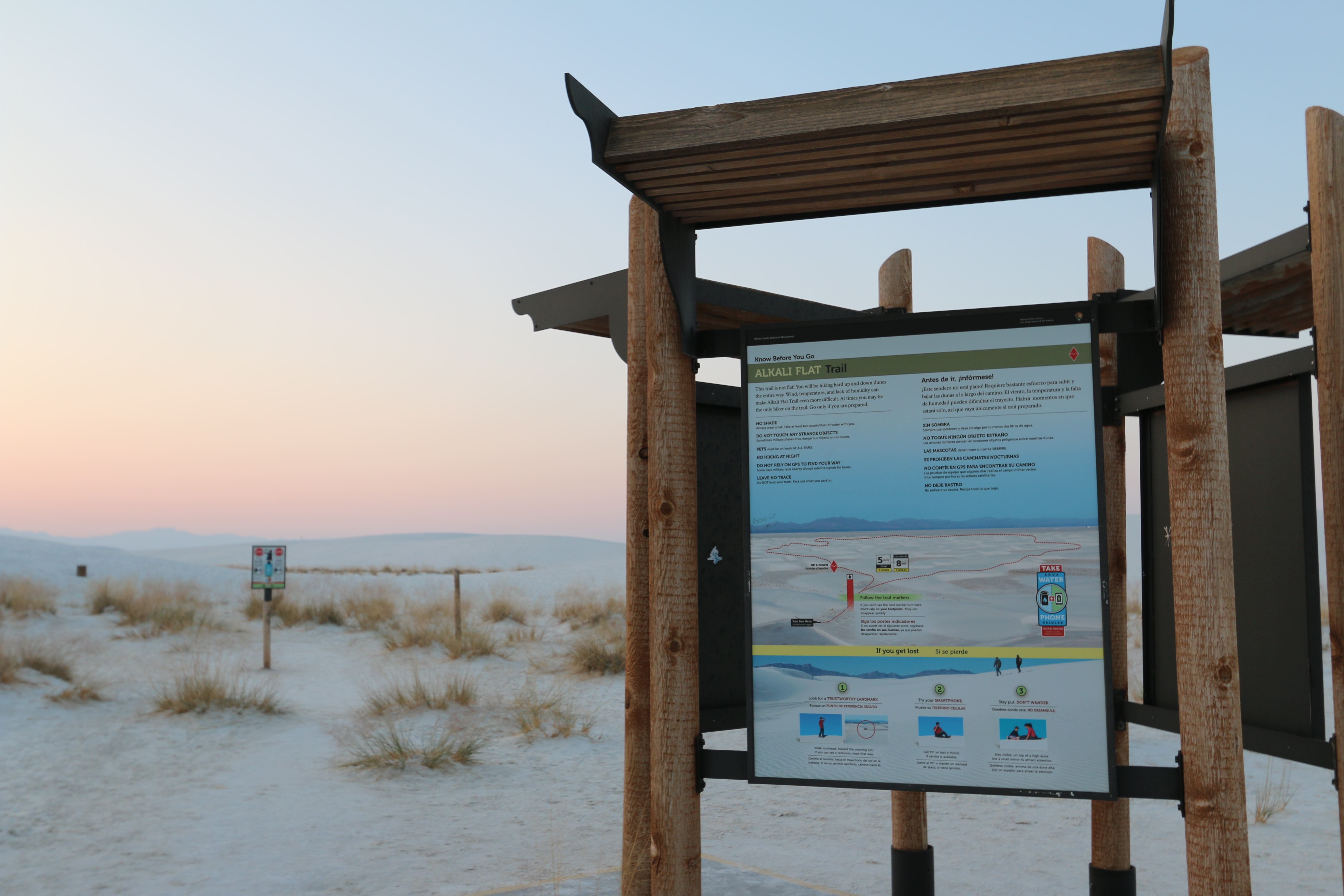
This is the only interpretive sign on the Alkali Flat Trail.
This three foot by four foot sign hangs on the right side of the kiosk at the start of the trail. The background of the panel shows a bird’s eye view of four hikers on the crest of a dune, the white sand stretching out in front of them to the base of a steep, mountain ridge. There are five photographs placed on the background all showing different views of the dunes some with rounded tops, others forming sharp ridges. Ripples cover the surface of the sand. At the top is text in both English and Spanish, which reads, “The Alkali Flat Trail is more about the journey than the destination. You will hike across the very heart of the dunefield. Here you can experience untouched sand and wide open vistas atop every dune. Across the middle of the panel is text in both English and Spanish, which reads, “Alkali Flat- Once a massive lake, Alkali Flat now stretches 9 miles across from the base of mountains to the west to the edge of dunes at the end of this trail. It measures 17 miles from north to south.” (27km)
This interpretive sign showcases just how world-renowned White Sands National Park is. As the world's largest gypsum sand dunefield, White Sands has been featured in over 20 major films since 1950.
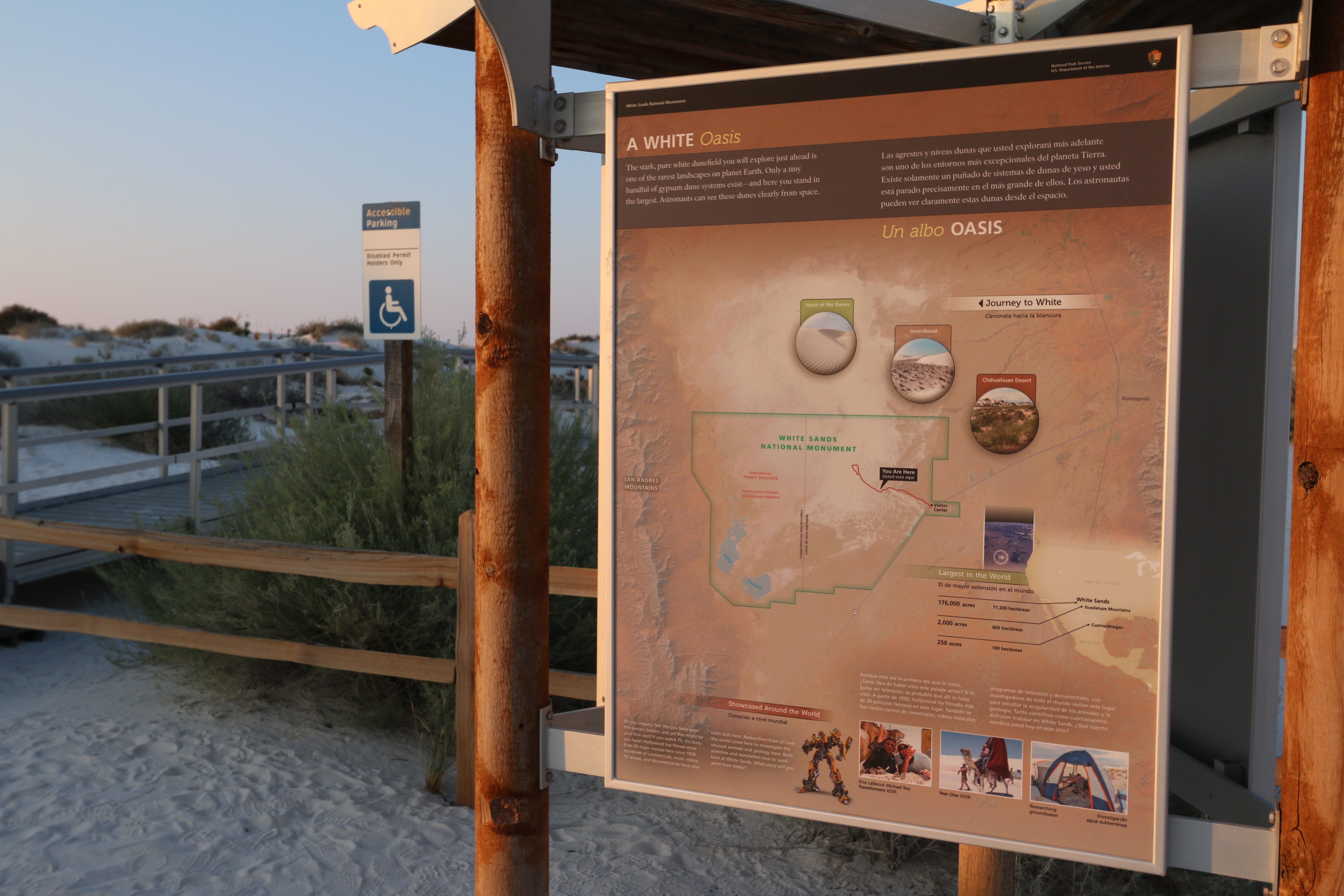
This 3-foot by 4-foot sign hangs on the front side of the kiosk at the start of the boardwalk. The background of the panel shows a satellite view of the region with the San Andres Mountains extending up the left side of the image. In the middle is a large white area surrounded by light brown. White Sands National Monument is outlined in green, including the bottom half of the white area. Within the lower left corner of the park boundaries are two blue patches labeled “Lake Lucero.” A vertical black line through the park marks the Cooperative Use Area Boundary. The left half of the park is labeled, “Restricted area – Permit Required.” On the right half of the park area the road is outlined in red, extending from the Visitor Center half way up the eastern edge into the center of an intense white zone. To the right of the park outlines is a small map of the United States and Mexico with the location of White Sands marked in the lower southwest. Text tells us that it is the largest in the world at 176,000 acres. Another dot slightly south east of White Sands locates the Guadalupe Mountains, with 2,000 acres. Another dot further south in Mexico locate 250 acres at Cuatrociénegas. A small inset photograph shows that the white area is visible even from space. Three small photographs above the park outline shows the different zones within the park. One labeled “Chihuahuan Desert,” shows flat land covered with the grasses and small bushes. To the left of that one in the Innerdunal zone, a flat basin bordered by white dunes that has spotty vegetation on it. The left-hand photo shows a pure white sand dune with ripples left by the wind. It is labeled “Heart of the Dunes.” At the top is text in both English and Spanish that reads, “The stark, pure white dunefield you will explore just ahead is one of the rarest landscapes on planet Earth. Only a tiny handful of gypsum dune systems exist—and here you stand in the largest. Astronauts can see these dunes clearly from space.” At the bottom is a picture of a metal robot creature. Text reads, “Showcased Around the World. Do you vaguely feel like you have seen this scenery before, and yet this might be your first visit? If you watch TV, it’s likely you have! Hollywood has filmed more than 20 major movies here since 1950. Hundreds of commercials, music videos, TV shows, and documentaries have also been shot here. Researchers from all over the world come here to investigate the unusual animals and geology here. Both scientists and storytellers love to work here at White Sands. What story will you write here today?” To the right are three small photographs. From left to right, the first shows two men lying in sand, pointing upward. The caption reads, “Shia LaBeouf, Michael Bay, Transformers, 2006. The next shows a man riding a camel with a huge tent on its back. The caption reads, “Year One, 2008.” The final one shows a mesh-sided tent. Inside a man sits at a table. The caption reads, “Researching groundwater.”
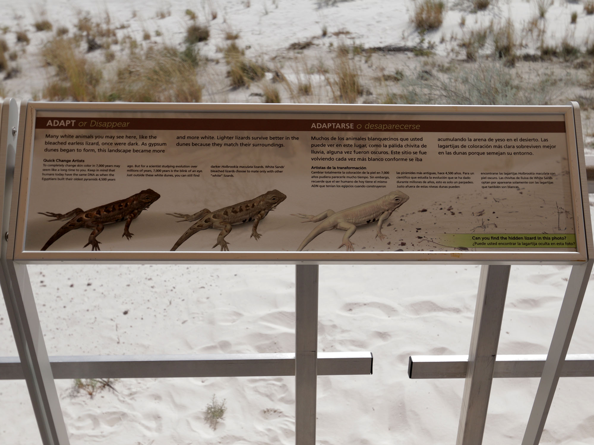
This interpretive sign showcases how creatures at White Sands have adapted their coloring to better survive in this blindingly white environment.
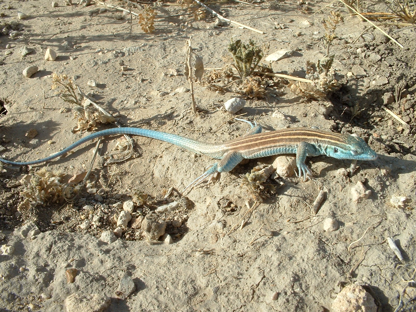
This 3 and 1/2 foot by 1 foot sign is mounted on the railing under the tent shelter along the boardwalk. Along its bottom are pictures of three lizards, identical in shape. The one on the left is brown with darker, inverted chevron markings running down its back. The middle lizard is much lighter brown with the same chevron markings. The one on the right is completely white with no markings on its back at all. At bottom left is a picture of a sandy surface, with a few small stones scattered about. In the center is just visible a white lizard, a dark shadow underneath him. Text asks, “Can you find the hidden lizard in this photo?” At the top is text in both English and Spanish, which reads, “Many white animals you may see here, like the bleached earless lizard, once were dark. As gypsum dunes began to form, this landscape became more and more white. Lighter lizards survive better in the dunes because they match their surroundings. “Quick Change Artists. To completely change skin color in 7,000 years may seem like a long time to you. Keep in mind that humans today have the same DNA as when the Egyptians built their oldest pyramids 4,500 years ago. But for a scientist studying evolution over millions of years, 7,000 years is the blink of an eye. Just outside these white dunes, you can still find darker Holbrookia maculata lizards. White Sands’ bleached lizards choose to mate only with other “white” lizards.”
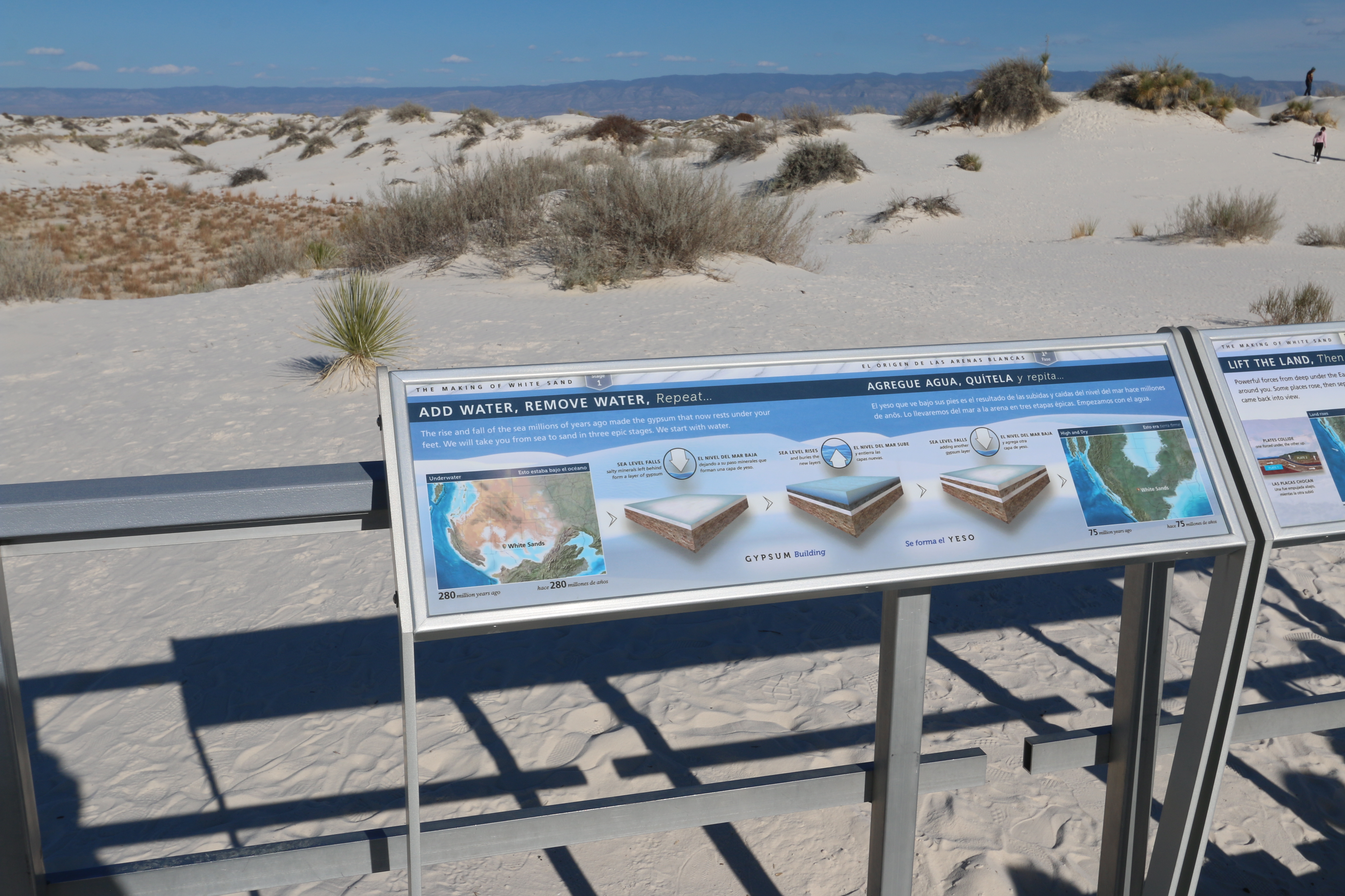
This interpretive sign showcases the geologic processes that formed the White Sands dunefield.
This three and one half foot by one foot sign is mounted on the platform railing at the end of the boardwalk. Against a background of an image of the white dunes, illustrations across the panel show the geologic process of creating the white gypsum that forms the dunes. At the top is text in both English and Spanish, which reads, “The Making of White Sands, Stage 1. The rise and fall of the sea millions of years ago made the gypsum that now rests under your feet. We will take you from sea to sand in three epic stages. We start with water.” At the left side of the panel is a map that shows the western United States as it looked 280 million years ago. An inland sea open to the west covers western Texas and southern New Mexico, putting the location of White Sands under water. To the right of the map is a drawing of a slab of earth covered by a layer of white. Text reads, “SEA LEVEL FALLS. Salty minerals left behind form a layer of gypsum.” In the middle of the panel, a drawing shows that slab of gypsum-covered earth with a layer of water on top. Text reads, “SEA LEVEL RISES and buries the new layers.” To the right of that a final drawing shows a second layer of gypsum-topped soil on top of the original one. Text reads, “SEA LEVEL FALLS adding another gypsum layer.” At the right of the panel a final map shows the western US at 75 million years ago. A broad swath of land from western Wyoming down through Utah, Nevada, Arizona and west Texas is now high and dry, with an inland sea to the north covering the Dakotas, Nebraska and most of Colorado.
This is one segment of the kiosk panel at the start of the Alkali Flat Trail at White Sands National Park.
This three foot by four foot sign hangs on the front side of the kiosk at the start of the trail. The background of the panel shows a bird’s eye view of the white dunefield looking towards the mountains in the west. The path of the trail is marked by a dotted red line, making a rough loop shape across the dunes. A label at the bottom of the picture at the edge of the parking area reads, “You are here.” Other labels indicate that the trail goes up and down and is a 5-mile loop (8km), which takes about 3 hours roundtrip. On the right a label reminds us to take water and a cellular phone on every trail, every time. Text reads, “Follow the trail markers. If you can’t see the next marker turn back. Don’t rely on your footprints. They can disappear quickly.” At the top is text in both English and Spanish, which reads, “Know before you go. Alkali Flat Trail. This trail is not flat! You will be hiking hard up and down dunes the entire way. Wind, temperature, and lack of humidity can make Alkali Flat Trail even more difficult. At times you may be the only hiker on the trail. Go only if you are prepared. NO SHADE. Always wear a hat. Take at least two quarts/liters of water with you. DO NOT TOUCH ANY STRANGE OBJECTS. Sometimes military planes drop dangerous objects on our dunes. PETS must be on leash AT ALL TIMES. NO HIKING AT NIGHT. DO NOT RELY ON GPS TO FIND YOUR WAY. Some days military tests nearby disrupt satellite signals for hours. LEAVE NO TRACE. Do NOT bury your trash. Pack out what you pack in.” A section along the bottom of the panel is titled “If you get lost.” Step 1 – look for a trustworthy land mark. “Walk southeast, toward the morning sun. If you can see a restroom, head that way.” Small photographs show a man standing on top of a dune looking off to the right. Another photograph shows a small restroom building visible in the dunes. Step 2 – “Try your smartphone. Call 911 or text a friend, if service is available.” A photograph shows a man sitting on top of a dune, cell phone held to his ear. Step 3 – “Stay put, don’t wander. Stay visible, on top of a high dune. Use a small mirror to attract attention.” A photograph shows a group of three people sitting on top of a dune.
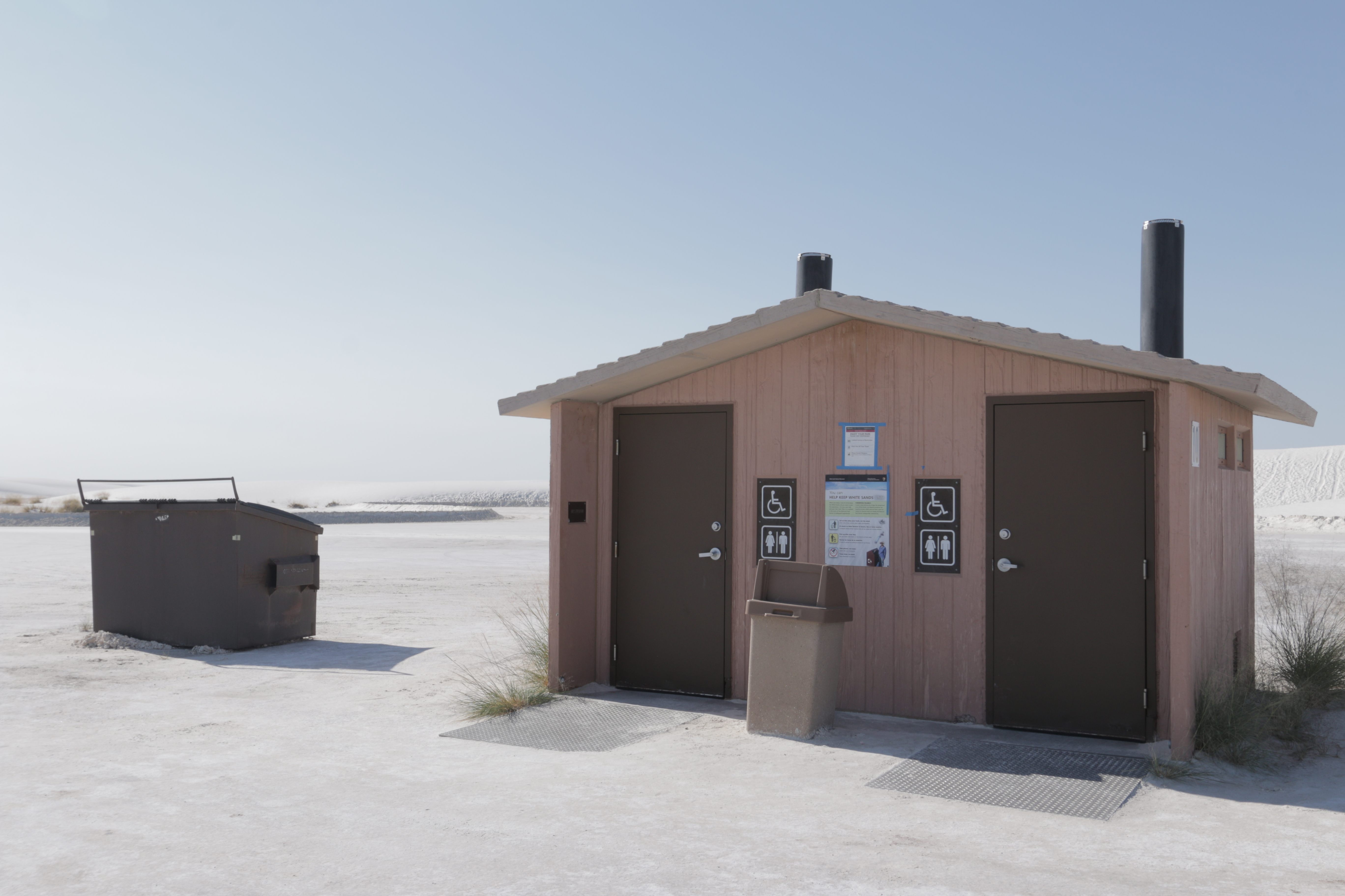
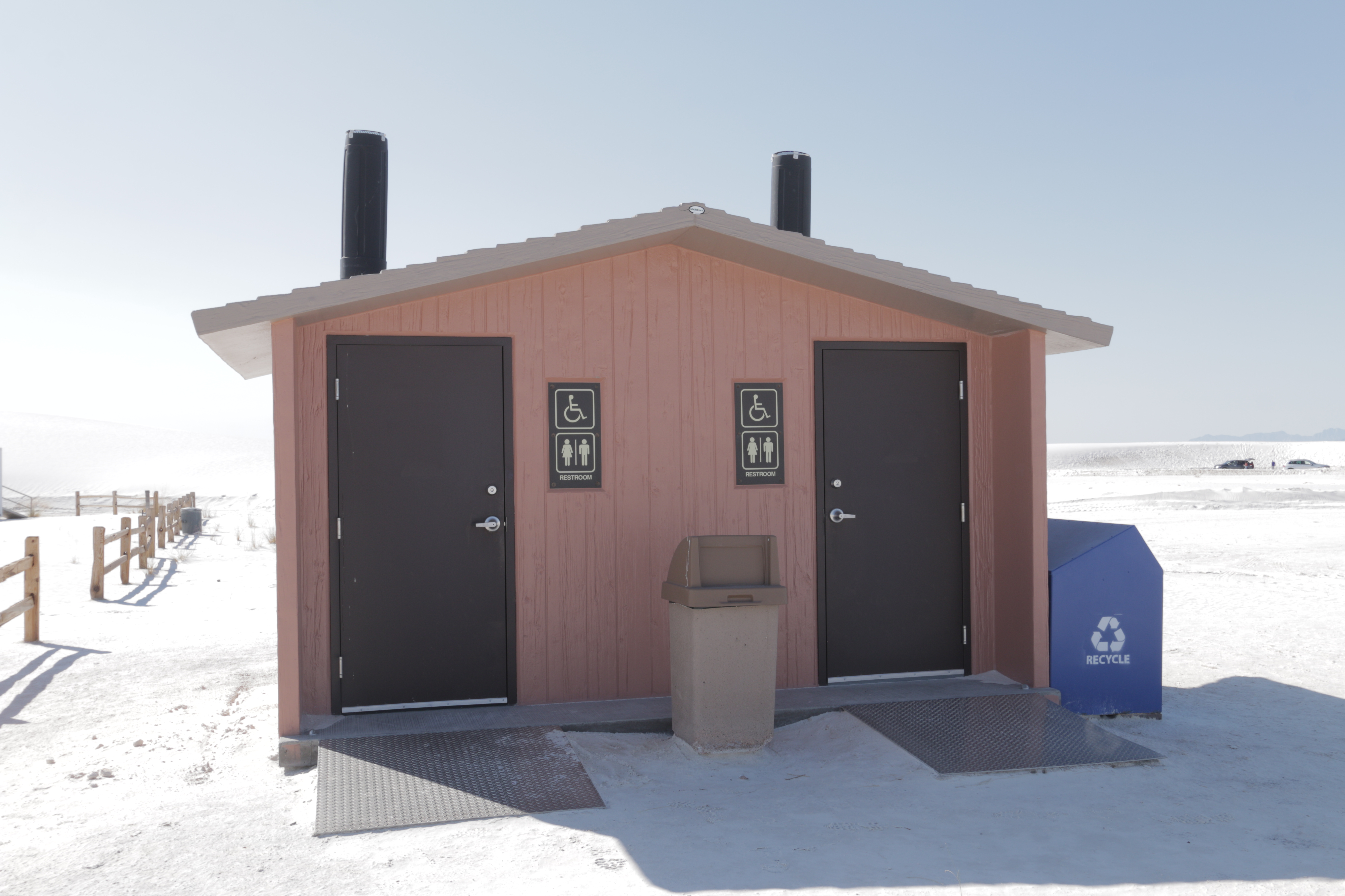
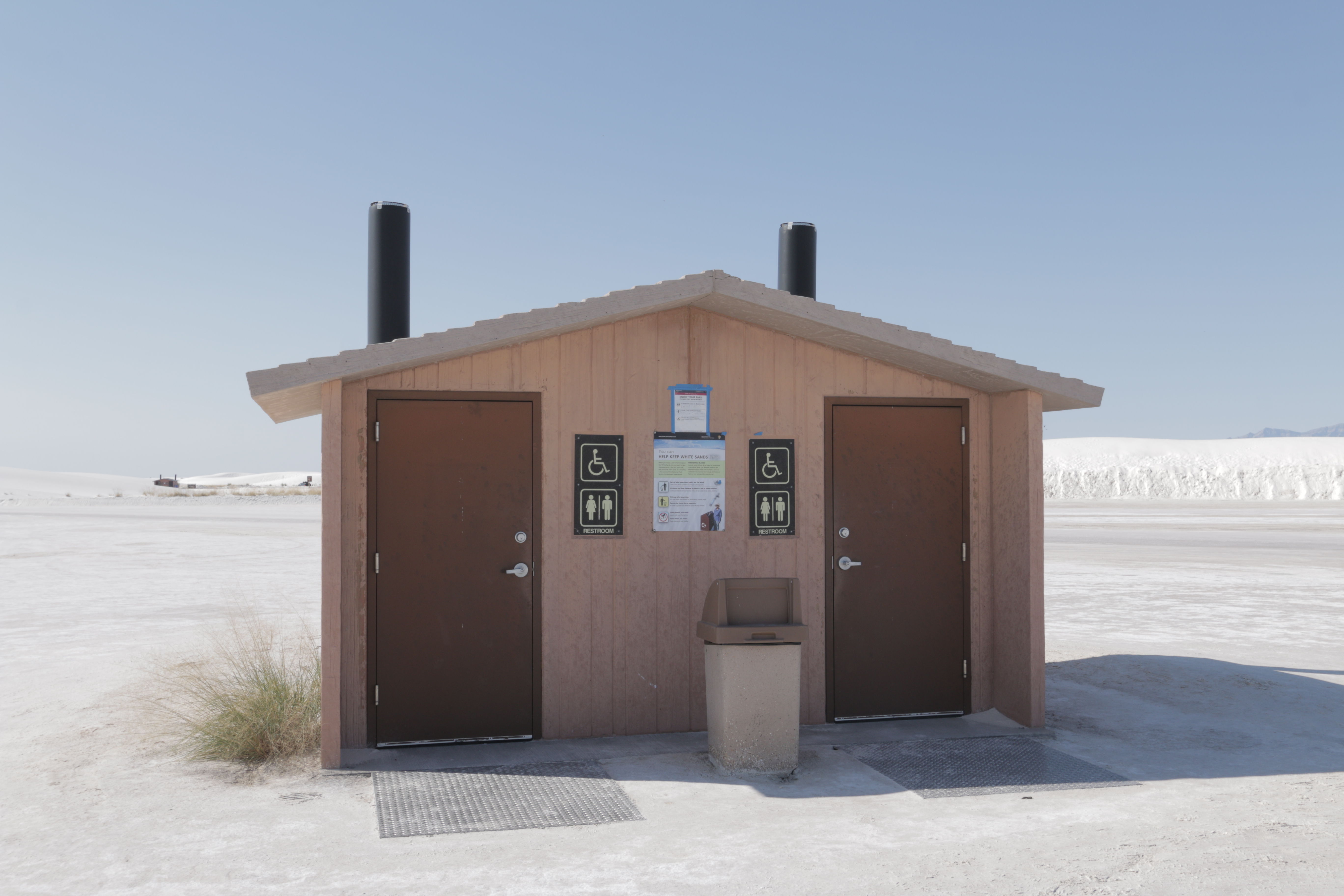
This is one of many restrooms at White Sands National Park.
The restroom buildings are house-shaped, with tan wood paneling exteriors and concrete bases. There are two dark brown metal doors on both ends of the buildings, each opening up to a small concrete room with one vault toilet in each. There are two brown cylindrical vents poking out of the roof, one above each toilet. In between both doors are two brown square signs stacked on top of each other, one with a wheelchair denoting accessibility, and the other with female and male stick figures separated by a vertical line and the word "restroom" underneath them. In between the stacked signs is an interpretive sign showing ways visitors can manage their waste and "Help Keep White Sands White." It encourages visitors to throw waste away in the proper receptacles, pick up after their pets, and "take photos, not sand." This restroom in particular is at the edge of a large gypsum sand parking lot. The building is surrounded by rolling white dunes with sparse vegetation, and is near the Alkali Flat trailhead.
The Alkali Flat Trail is the most strenuous trail at White Sands National Park. It offers an unparalleled view of the dunefield as well as Alkali Flat itself.
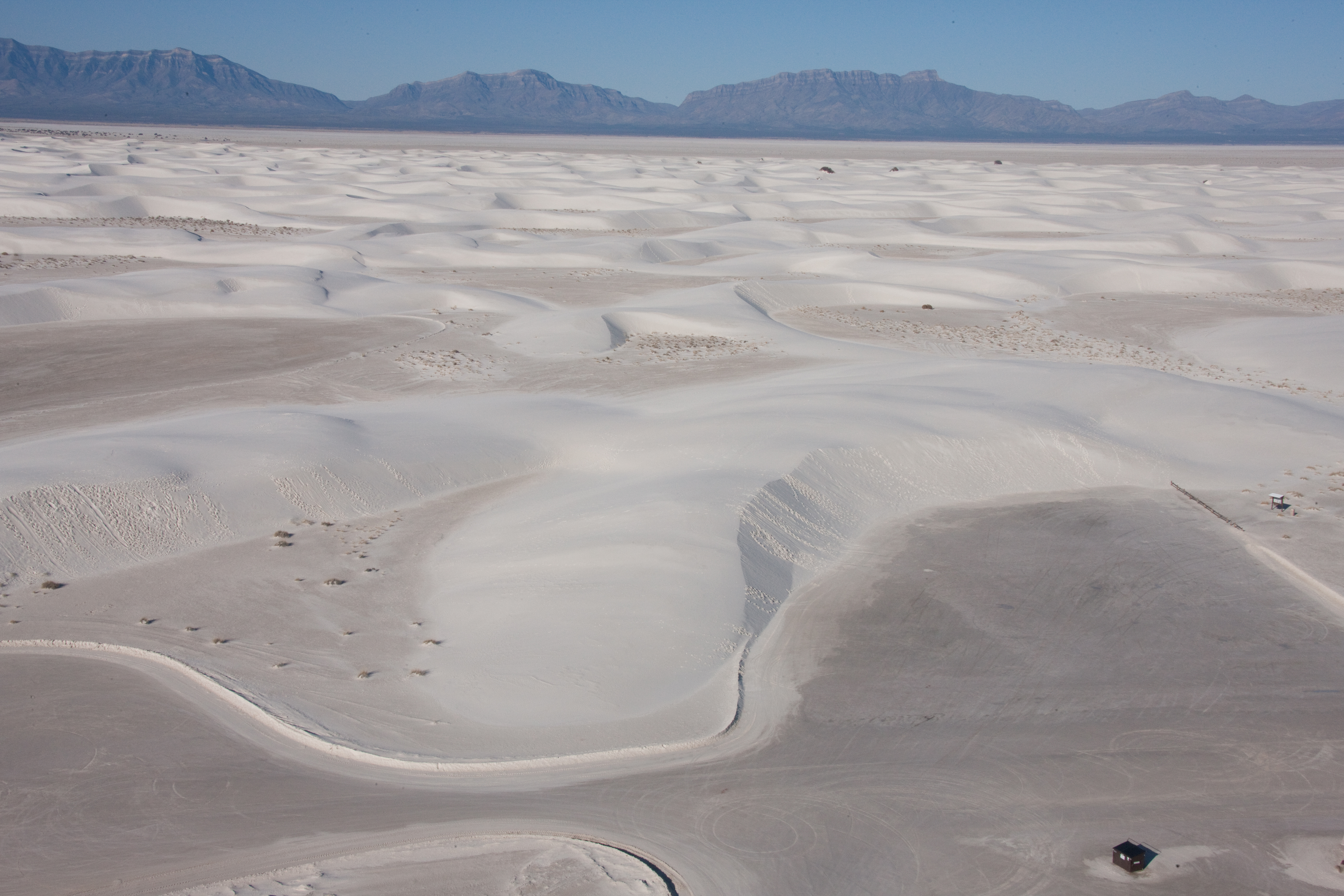
This trail begins at a large parking area on the side of the road. Both the road and the parking are hard-packed sand. Near the start of the trail the parking area is edged with a split-rail fence. Just past the fence is a tall, three-sided kiosk with three graphic panels that discuss safety and describe the trail. As you face the fence a restroom building is located at the end of the parking area to your right. The trail is marked by flat, four inch wide, red posts with a diamond symbol. From the kiosk, it leads across a flat basin with scattered tufts of tall grass into the dunes themselves. The trail proceeds up and down the dune slopes, pure white sand on all sides. In many places, the surface is covered with small ripples of sand, which glitters under the bright sun. The footing varies from a firm hard pack to deep, soft sand on some of the slopes. Once out of sight of the parking area, you are in a sea of sand stretching out on all sides, with the distant mountains on the western horizon just visible.
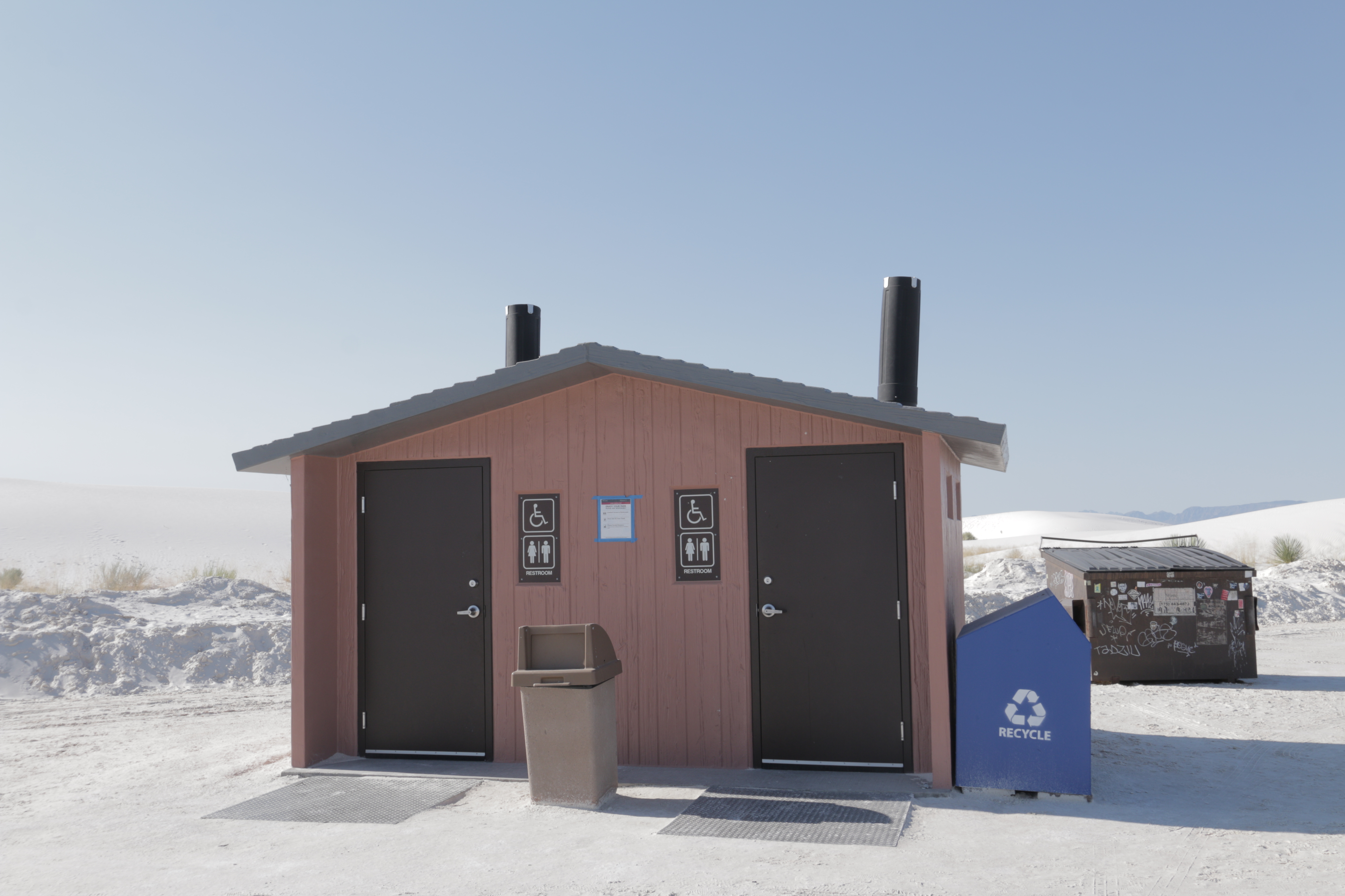
This is one of many restrooms at White Sands National Park.
The restroom buildings are house-shaped, with tan wood paneling exteriors and concrete bases. There are two dark brown metal doors on both ends of the buildings, each opening up to a small concrete room with one vault toilet in each. There are two brown cylindrical vents poking out of the roof, one above each toilet. In between both doors are two brown square signs stacked on top of each other, one with a wheelchair denoting accessibility, and the other with female and male stick figures separated by a vertical line and the word "restroom" underneath them. In between the stacked signs is an interpretive sign showing ways visitors can manage their waste and "Help Keep White Sands White." It encourages visitors to throw waste away in the proper receptacles, pick up after their pets, and "take photos, not sand." This restroom in particular is a large, gypsum sand parking lot. The building is surrounded by rolling white dunes, with sparse vegetation scattered throughout. It is separated from the amphitheater with brown wooden fencing, and has a blue recycling unit next to it.
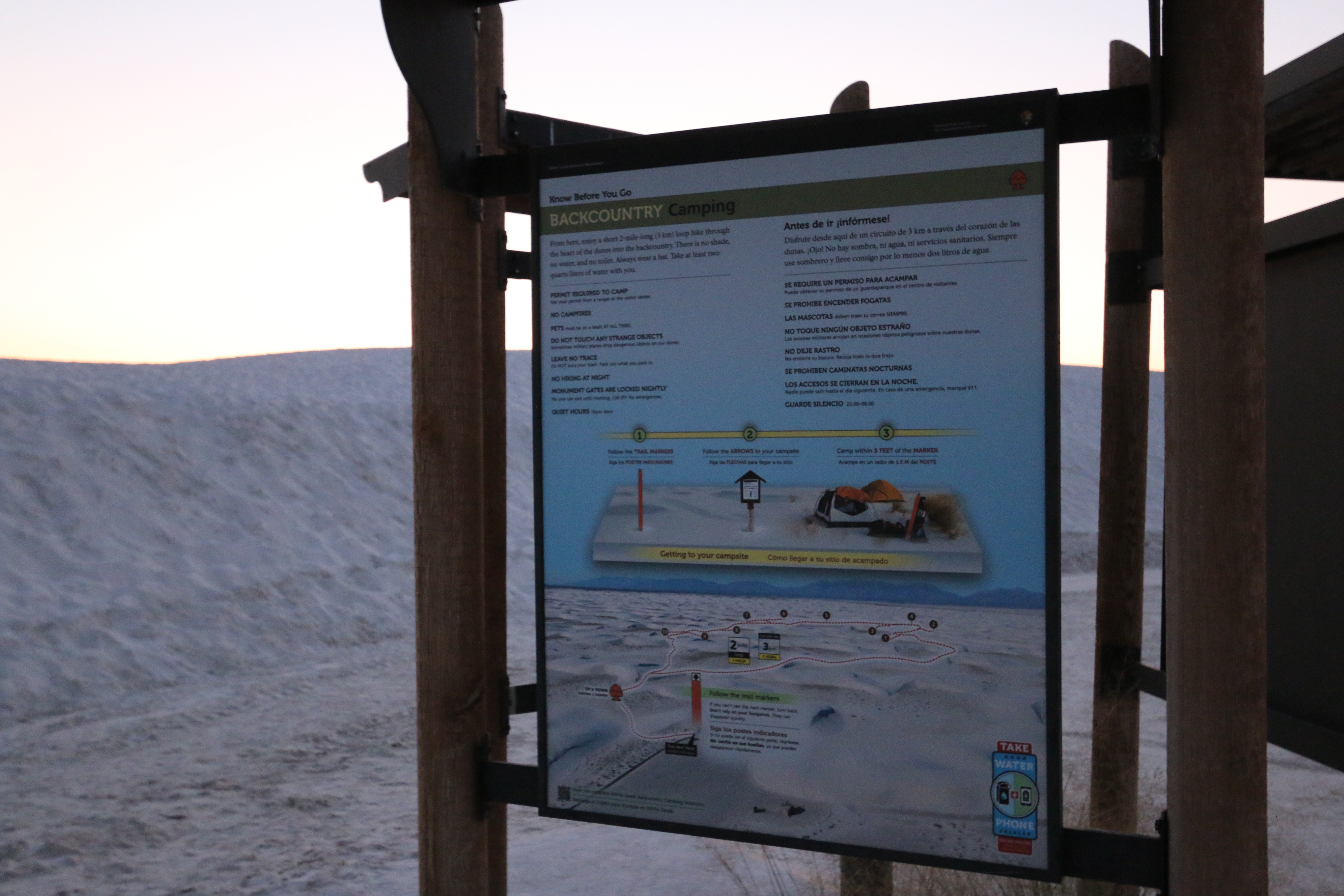
This is the informational panel for backcountry camping at White Sands National Park.
This three foot by four foot sign hangs on one side of the kiosk at the start of the trail. The background of the panel shows a bird’s eye view of the white dunefield looking towards the mountains in the west. The path of the trail is marked by a dotted red line, making a rough loop shape across the dunes. Numbers 1 through 10 mark the locations of the camp sites. A label at the bottom of the picture at the edge of the parking area reads, “You are here.” Other labels indicate that the trail goes up and down and is a 2-mile loop, which takes about 1 hour roundtrip. On the right a label reminds us to take water and a cellular phone on every trail, every time. Text reads, “Follow the trail markers. If you can’t see the next marker turn back. Don’t rely on your footprints. They can disappear quickly.” At the top is text in both English and Spanish, which reads, “Know before you go – Backcountry Camping. From here, enjoy a short 2-mile-long (3 km) loop hike through the heart of the dunes into the backcountry. There is no shade, no water, and no toilet. Always wear a hat. Take at least two quarts/liters of water with you. “PERMIT REQUIRED TO CAMP. Get your permit from a ranger at the visitor center. NO CAMPFIRES. PETS must be on a leash AT ALL TIMES. DO NOT TOUCH ANY STRANGE OBJECTS. Sometimes military planes drop dangerous objects on our dunes. LEAVE NO TRACE. Do NOT bury your trash. Pack out what you pack in. NO HIKING AT NIGHT. MONUMENT GATES ARE LOCKED NIGHTLY. No one can exit until morning. Call 911 for emergencies. QUIET HOURS 10pm–6am.” Across the middle of the panel are three reminders for getting to your campsite. First, follow the trail markers. Second, follow the arrows to your campsite. Third, camp within 5 feet of the site marker.
The Backcountry Camping Loop Trail is a moderate hike that takes visitors into the heart of the dunefield.
This trail begins at a parking area at the side of the road. Near the start of the trail the parking area is edged with a split-rail fence. In front of the fence is a tall, three-sided kiosk with three graphic panels. To the right of the kiosk as you face the trail is a picnic shelter and table. At the far side of the parking area is a small restroom building. Near the beginning of the trail is a small sign that reads, “Parking for Backcountry Camping. Permit required. Available at Visitor Center.” The trail is marked by flat, four inch wide, orange posts with a spade symbol. From the kiosk, it follows a low ridge on the right, across a flat area, then up a slope to a sign where the trail splits to make a loop. That sign has a map of where the camp sites are located around the loop, sites 1 – 5 to the right and 6 – 10 to the left. At that point you are surrounded by the white dunes rising and falling on all sides, with distant mountains visible both to the west and the east. The dunes are bare white sand, often with ripples across their surface. In between are small flat basins with some clumps of grass, small bushes and an occasional yucca plant.
This is one of many restrooms at White Sands National Park.
The restroom buildings are house-shaped, with tan wood paneling exteriors and concrete bases. There are two dark brown metal doors on both ends of the buildings, each opening up to a small concrete room with one vault toilet in each. There are two brown cylindrical vents poking out of the roof, one above each toilet. In between both doors are two brown square signs stacked on top of each other, one with a wheelchair denoting accessibility, and the other with female and male stick figures separated by a vertical line and the word "restroom" underneath them. In between the stacked signs is an interpretive sign showing ways visitors can manage their waste and "Help Keep White Sands White." It encourages visitors to throw waste away in the proper receptacles, pick up after their pets, and "take photos, not sand." This restroom in particular is at the edge of a large gypsum sand parking lot. When facing the doors of the restroom, visitors can see rolling white dunes with sparse vegetation behind the building. The doors face a large parking area with white dunes off in the distance, as well as a gypsum sand road called Dunes Drive. Next to this restroom is a blue recycling unit and a large dark brown dumpster.
This is one of many restrooms at White Sands National Park.
The restroom buildings are house-shaped, with tan wood paneling exteriors and concrete bases. There are two dark brown metal doors on both ends of the buildings, each opening up to a small concrete room with one vault toilet in each. There are two brown cylindrical vents poking out of the roof, one above each toilet. In between both doors are two brown square signs stacked on top of each other, one with a wheelchair denoting accessibility, and the other with female and male stick figures separated by a vertical line and the word "restroom" underneath them. In between the stacked signs is an interpretive sign showing ways visitors can manage their waste and "Help Keep White Sands White." It encourages visitors to throw waste away in the proper receptacles, pick up after their pets, and "take photos, not sand." This restroom in particular is next to a gypsum sand road called Dunes Drive. The building is surrounded by large white dunes, with sparse vegetation scattered throughout.
There are many Hoary Rosemary Mint and Skunkbush Sumacs in this location. They are not as big as the plants you have seen so far but are raised from the ground slightly and have hard sand under them. In this area, animals that want to dig a hole in hardened sand to make a home would have plenty of places to choose. It is sheltered slightly from the wind, so the plants do well here.
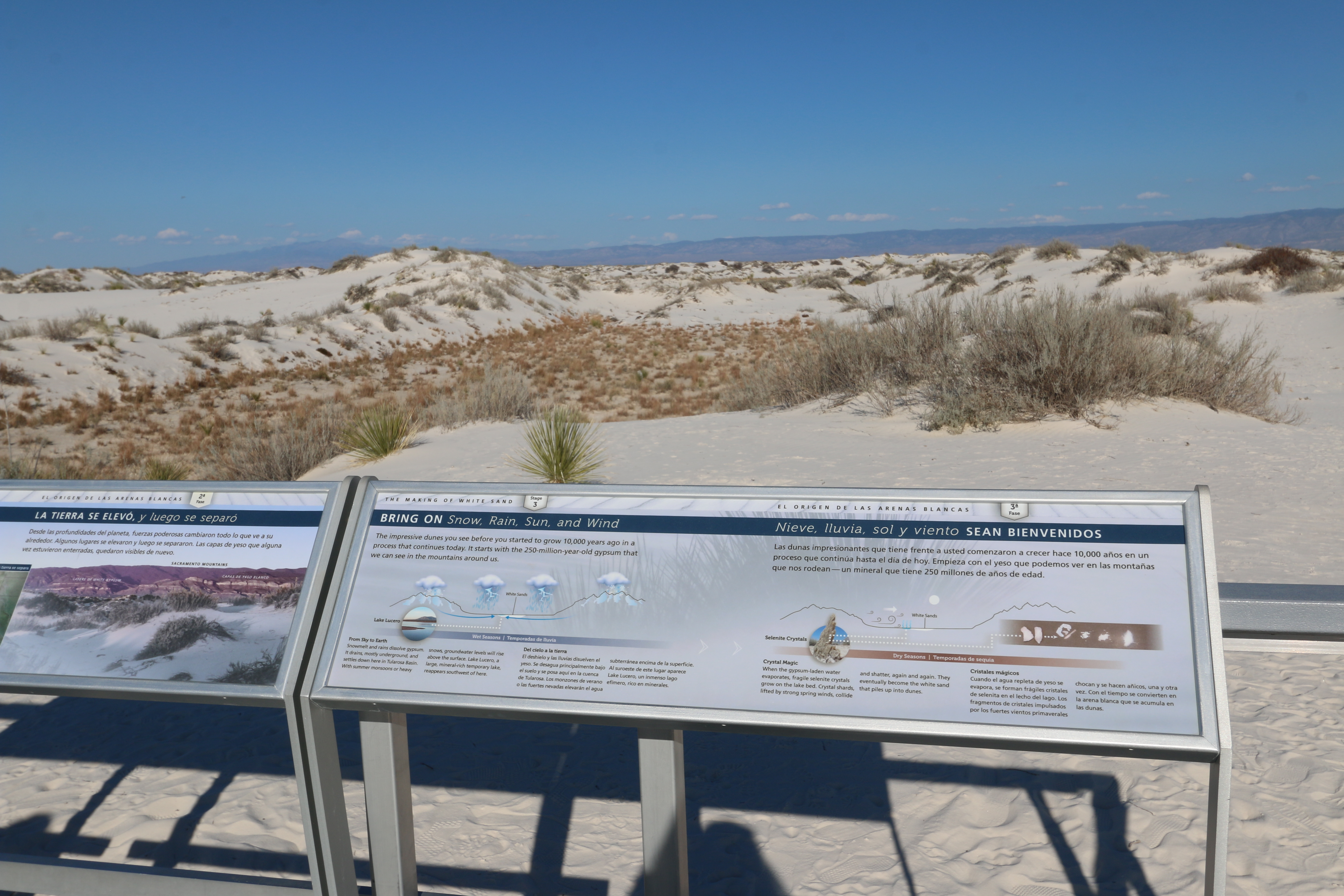
This interpretive sign showcases the many ways that weather helps create White Sands' gypsum sand dunefield.
This three and one half foot by one foot sign is mounted on the platform railing at the end of the boardwalk. The left side of the panel has an illustration of what happens in the dune during wet seasons. The right side shows the process during dry seasons. At the top is text in both English and Spanish, which reads, “The Making of White Sands, Stage 3. The impressive dunes you see before you started to grow 10,000 years ago in a process that continues today. It starts with the 250-million-year-old gypsum that we can see in the mountains around us.” The illustration on the left end of the panel shows White Sands with Lake Lucero at its western edge located in the valley between two mountain ranges. Clouds produce snow over the mountains and thunder storms in the basin, with rain and snow-melt flowing in to the valley. Text reads, “From Sky to Earth. Snowmelt and rains dissolve gypsum. It drains, mostly underground, and settles down here in Tularosa Basin. With summer monsoons or heavy snows, groundwater levels will rise above the surface. Lake Lucero, a large, mineral-rich temporary lake, reappears southwest of here.” The illustration on the right end of the panel shows the same scene with the sun blazing overhead, leading to water evaporating. Winds blow from west to east. Text reads, “Crystal Magic. When the gypsum-laden water evaporates, fragile selenite crystals grow on the lake bed. Crystal shards, lifted by strong spring winds, collide and shatter, again and again. They eventually become the white sand that piles up into dunes.” Small images show selenite crystals, an oblong column with flat sides, and the resulting particles ranging from larger pieces to fine sand.
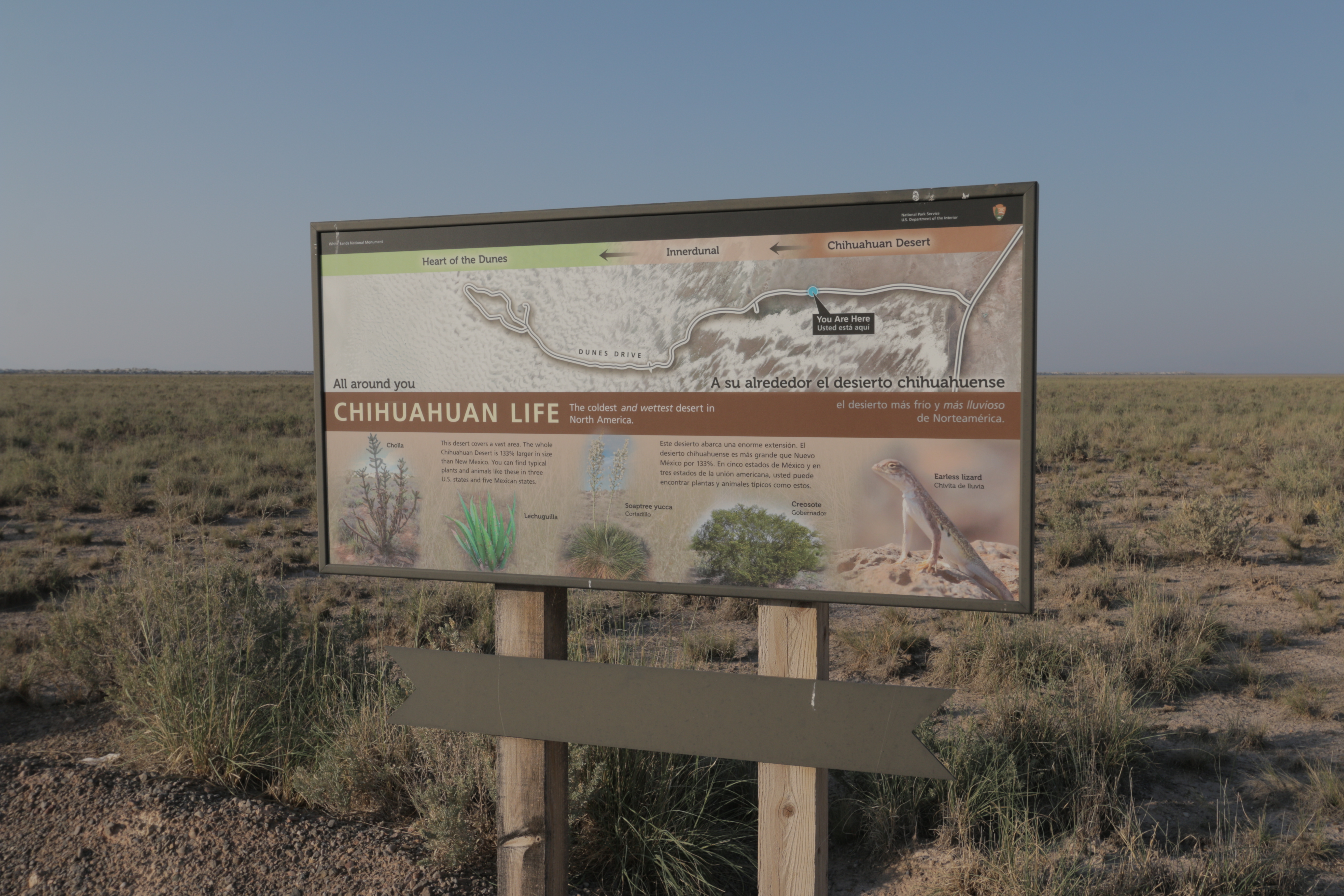
The "Chihuahuan Life" wayside at White Sands National Park highlights the coldest and wettest desert in North America.
This 4-foot by 2-foot sign is mounted on two wooden posts at the edge of a pullout along the road that winds its way into the heart of the dunes. The land behind the sign is flat, scrub-covered desert land, stretching out to the distant mountains in the east. On the other side of the road is a narrow strip of brush-covered land backed by low dunes with low, bushy vegetation on their slopes. The top half of the panel features an aerial view of this area showing the entrance road winding its way from the highway at the right into the heart of the dunes at the left, where it makes a loop. Labels at the top identify the changing landscape from the brown-colored Chihuahuan desert at the right, through a changing innerdunal zone, where the brown shows streaks of white, into the heart of the dunes which is totally white. A label marks your current location about tow-thirds of the way along the desert section. Across the middle of the panel is text in both English and Spanish that reads, “All around you, Chihuahuan life. The coldest and wettest desert in North America. This desert covers a vast area. The whole Chihuahuan Desert is 133% larger in size than New Mexico. You can find typical plants and animals like these in three U.S. states and five Mexican states.” Along the bottom of the panel are photographs of 4 different desert plants and one animal. From left to right, first is a cholla. It has thick stalks about 1 inch across with short stalks branching off, the surfaces covered by spones. Next is a picture of a lechuguilla. It has sword-like fleshy leaves rising from a central base. In the middle is a picture of a soaptree yucca with its mound of flat, sword-like leaves and tall stalks with bunches of white blossoms rising above. Next is a picture of a creosote. This bushy, green plant has small leaves on thin branches. At right is a picture of an earless lizard. Its back is brown dotted with yellow specks and its underbelly is white.
This sign, about two feet wide and one and one-half feet high, is mounted at an angle on a single metal post. The trail slopes down the dune past the sign and the next marker is clearly visible. On either side and behind you, the white sand stretches over the rolling dunes. Clumps of low bushes are scattered about. The sign has a picture of Katie, the cartoon fox figure, in the upper left, with text in both English and Spanish along the top. The bottom part of the sign has a picture of a Grasshopper Mouse, sitting back on its haunches, front paws held up to its mouth. It has a brown back and head, with lighter tan on its belly and front legs. Near the mouse is a shiny black stinkbug. Text at the top reads, “My fierce friends the grasshopper mice are almost 100% meat eaters—that is, if you think of deadly centipedes and scorpions as “meat.” They hunt at night like tiny cats. They claim and defend large territories—the size of 19 football fields. In a fight, they are as quick as lightning. After a kill, they get up on a rock, and let out a lion-like roar. How loud can you roar?” End of description.
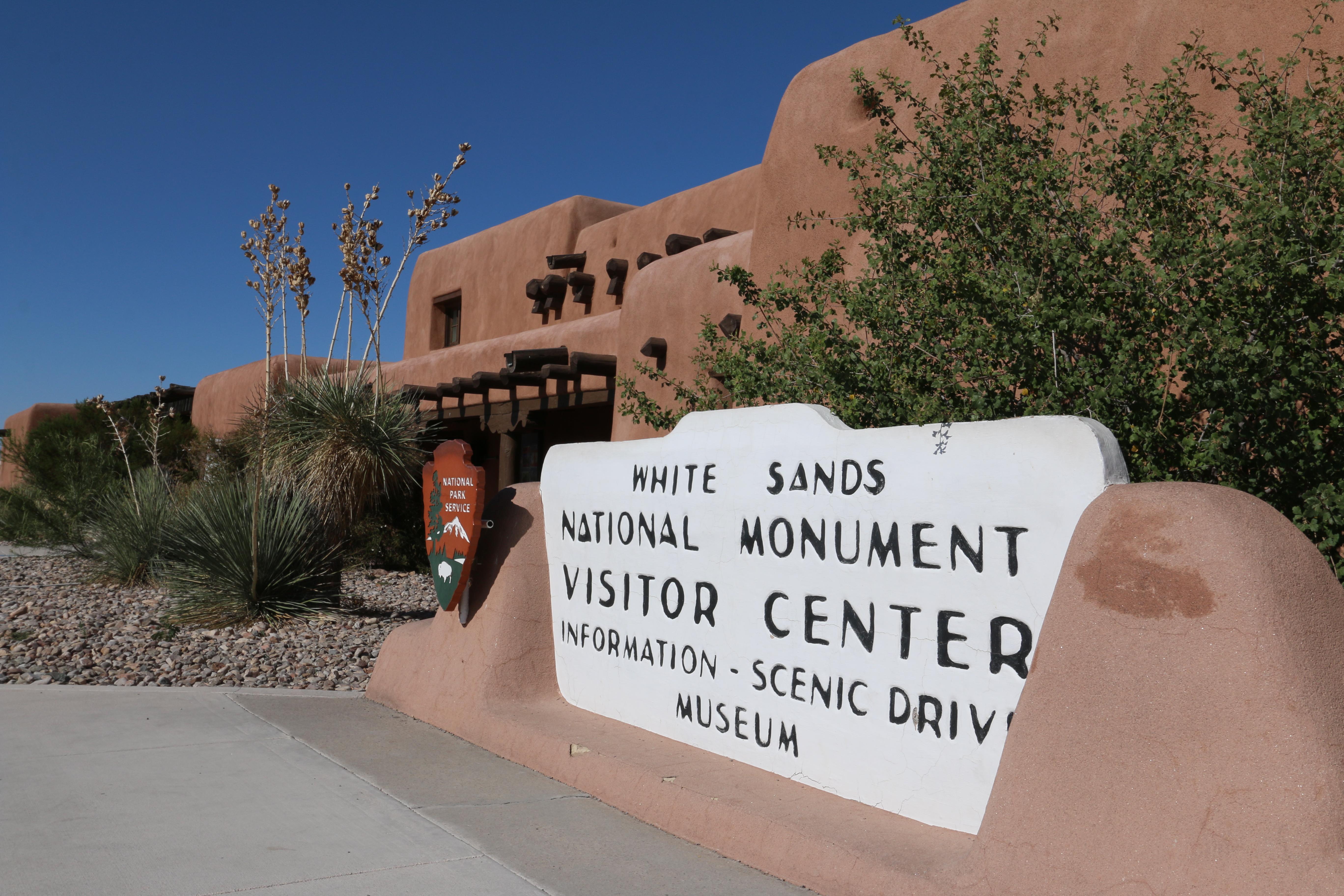
From the front parking lot, a two-story, adobe Pueblo Revival style visitor center and restrooms with large, pine log supports extending out of the sides of the building. In front of the visitor center, sidewalks wind through a gravel native plant garden featuring desert-adapted plants such as soaptree yucca, desert willow, and agave. Across the parking lot is an adobe wall with a flag pole and a sign that says "White Sands National Park" in front of the wall.
This trail begins at a parking area at the side of the road. Near the start of the trail the parking area is edged with a split-rail fence. In front of the fence is a tall, three-sided kiosk with three graphic panels. To the right of the kiosk as you face the trail is a picnic shelter and table. At the far side of the parking area is a small restroom building. Near the beginning of the trail is a small sign that reads, “Parking for Backcountry Camping. Permit required. Available at Visitor Center.”
This is one of the most explorable trails at White Sands National Park. Follow along with Katie the Kit Fox as she highlights some of the creatures and features of the white sand dunefield.
From the parking lot, the hard-packed dirt trail leads through the split-rail fence, past a three-sided kiosk with informational signs and then across flat grassland to the white dunes. The trail then ascends up the sand between two dunes to a wayside sign, where the loop trail then splits to the left and the right. The audio description follows the trail to the left, in a clockwise direction. The trail is marked by flat, four inch wide, blue posts marked with a three-leaved clover symbol. The trail meanders up and down the dunes, which are dotted with a variety of grasses, bushes and the occasional small tree. The footing varies from hard-packed dirt to soft sand. The parking lot is a loop and is adjacent to the vault toilets.. At the beginning of the trail near the parking lot a brown sign reads, “Dune Life Nature Trail. This one-mile loop trail winds through the edge of the white sands, where dune life is most abundant. Watch for the tracks left behind by various desert animals as they hunt for food among the dunes. Two steep climbs will be encountered on this walk. Summer temperatures can exceed 100 degrees Fahrenheit. Take plenty of water and protect your skin from the sun. Please lock your car.” Further down the trail another sign warns, “Stop – Stay Alive. Water required for this trail. Take 64 ounces or two liters of water for each person in your group. When your water is half gone, return to your car. Warning Dangerous to hike above 85 degrees Fahrenheit.”
This kiosk panel highlights information about one of White Sands' most popular trails.
This three foot four foot sign hangs on one side of a three-sided kiosk at the start of the Dune Life Nature Trail. The background of the panel features an aerial view of the trail with the parking lot located at the bottom of the image and distant mountains visible at the top. A dotted line marks the trail as it crosses the scrubby grassland, then ascends into the dunes and makes an irregularly shaped loop on the white dunes. Labels indicate your current position at the kiosk next to the parking lot and also states that the trail includes some up and down. At the top is text in both English and Spanish, which reads, “Know before you go: Dune Life Nature Trail. Ahead you will climb a steep slope and enter the shifting sands of the dunes. This is your first opportunity to walk on the sand. Keep in mind this trail is for observing plant and animal life. If you want to play in the sand, drive further down the road into the heart of the dunes, near the picnic areas. “NO SHADE. Always wear a hat. Take at least two quarts/liters of water with you. PETS must be on a leash AT ALL TIMES. DO NOT TOUCH ANY STRANGE OBJECTS. Sometimes military planes drop dangerous objects on our dunes. “FROM JUNE TO AUGUST, Do not hike in the hottest part of the day. KNOW WHAT TIME THE SUN SETS TODAY. Follow the trail markers. If you can’t see the next marker turn back. Don’t rely on your footprints. They can disappear quickly.” The trail is a one mile loop (1.6 km) and takes about one hour to complete.
The visitor center was built in 1936 and is part of the historic district at White Sands. Inside you will find the park store as well as the museum for the park. Make sure you check out the wayside in the visitor center courtyard to learn about the unique construction style that makes the visitor center an incredible example of the "Spanish Revival" architectural design.
The Dune Life Nature Trail is full of life! This family-friendly, one mile (1.6 km) loop trail is a great way to explore White Sands.
Sledding at the Roadrunner Picnic Area
The Roadrunner Picnic area is an excellent place to go sledding with friends and family at White Sands National Park.
Hiking the Playa Trail
This short, level, family-friendly trail leads to a small playa.
Hiking Backcountry Camping Trail
Are you looking for expansive views of snow-white gypsum dunes for miles? Hiking the Backcountry Camping Trail provides a sense of the magnitude of the world's largest gypsum dunefield.
Hiking Alkali Flat Trail
Imagine yourself surrounded by the spectacular views of endless dunes with few footprints. The Alkali Flat Trail takes you through the heart of the sands, up and over steep dunes to the edge of Alkali Flat.
Sledding at the Alkali Flat Trailhead
The Alkali Flat trailhead parking area has some of the tallest dunes to go sledding at White Sands.
Hiking Interdune Boardwalk
The Interdune Boardwalk is an elevated boardwalk that leads you through the fragile interdune area to a scenic view of the dune field and the Sacramento mountains.
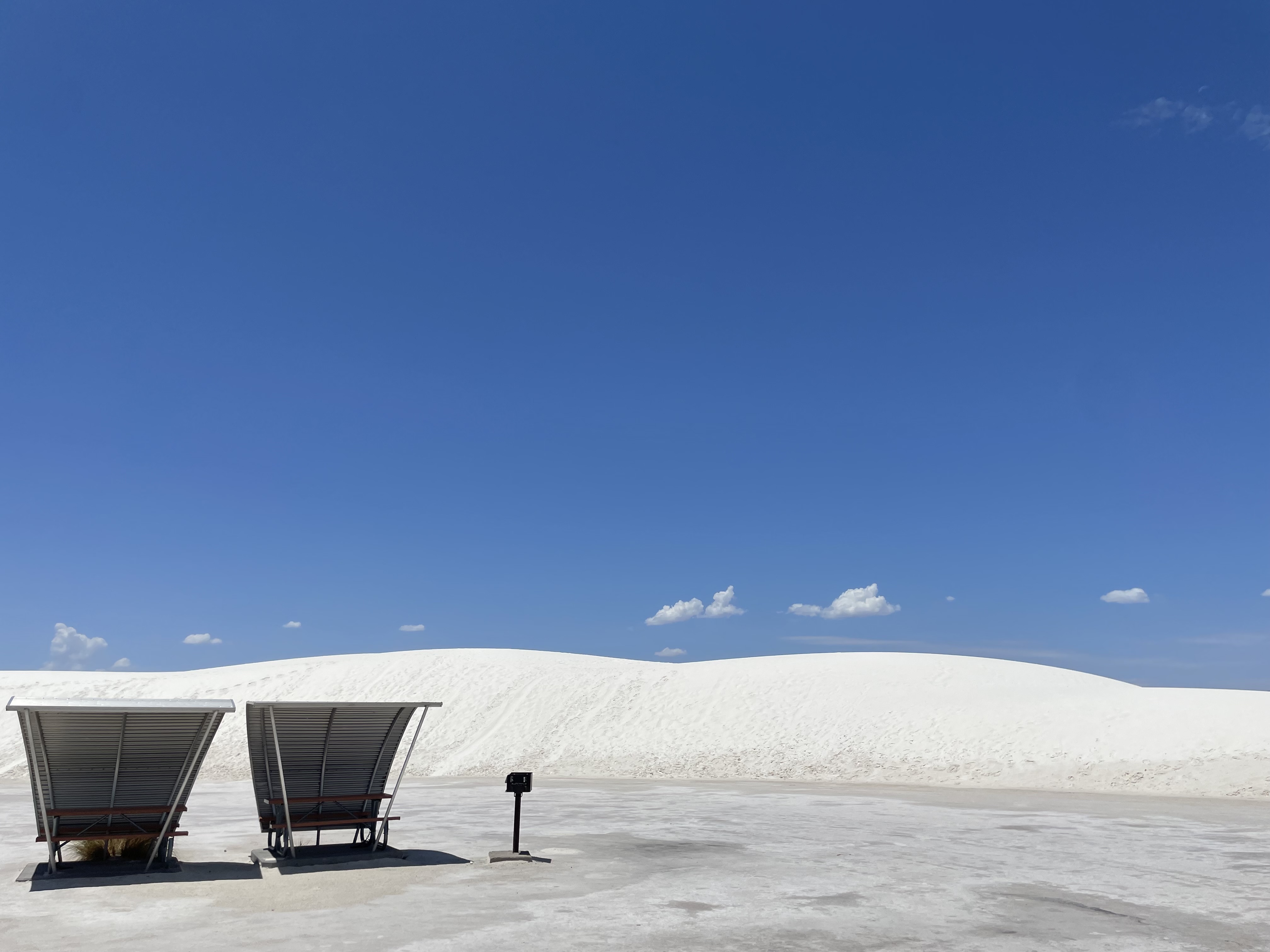
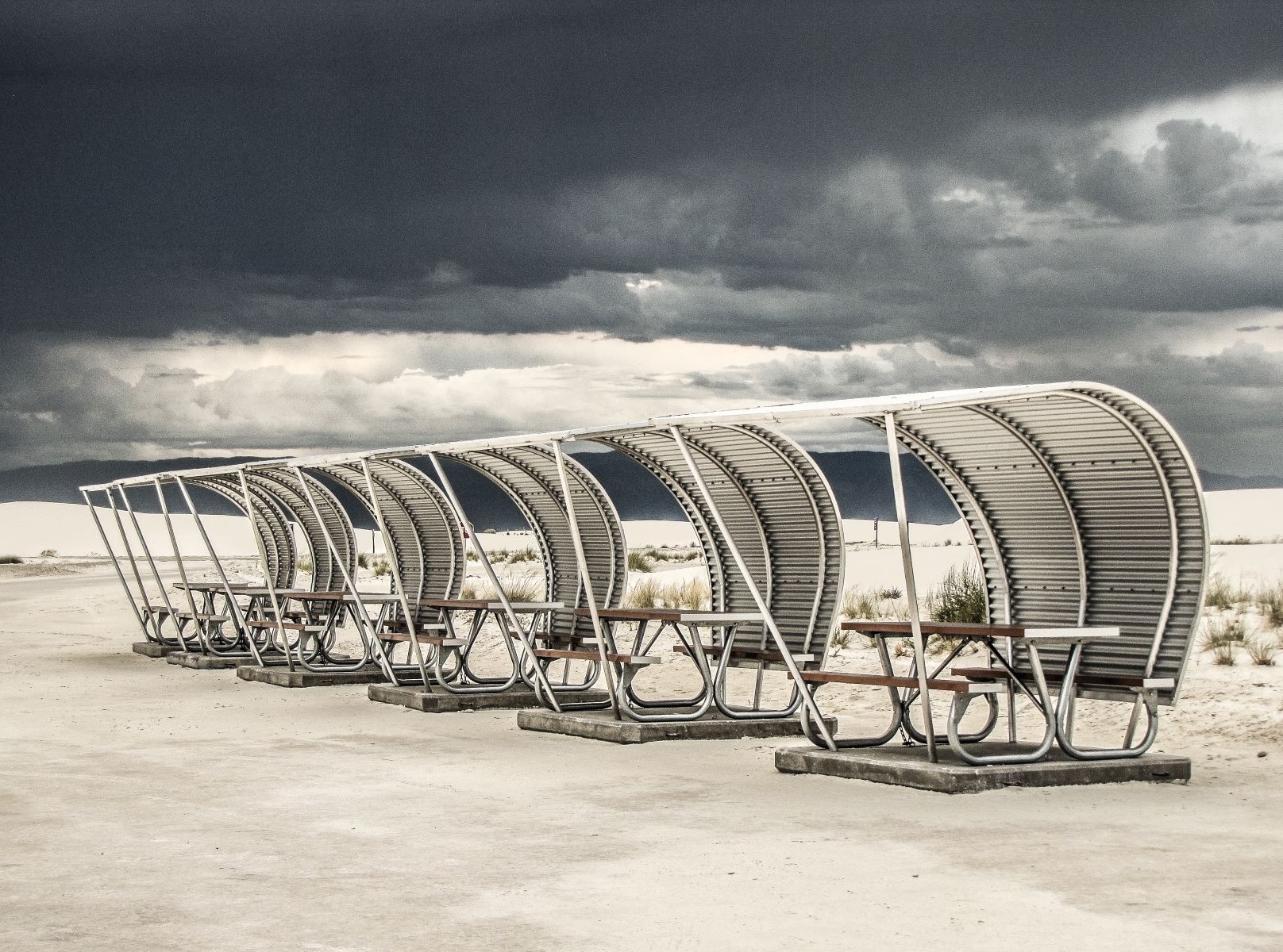
Picnicking at White Sands
White Sands National Park offers three picnic areas where people can enjoy shade, relaxation, and access to the parks incredible dunes.
Tours
Count: 4
Automobile Tour of Dunes Drive
This self-guided interpretive tour takes you on a driving tour of Dunes Drive, the scenic 8-mile park road that winds through the dunes. Along the way, stops will explore what makes White Sands National Park unique as a natural wonder and a place that has drawn humans for thousands of years.
Changes Over Time: Lesser Known Stories at White Sands
This self-guided interpretive tour takes visitors on the entirety of the Backcountry Camping Loop Trail, which is a moderate 2-mile hike through the dunefield. It dives into the ways human use in this giant sandbox has changed over the last century.
Moth Walk
To celebrate National Moth Week, join us on this accessible self-guided tour down the Interdune Boardwalk.
Mystery of the Dunes
This self-guided interpretive tour takes you on a sensory experience of the Dune Life Nature trail.