Be advised that the NPS has issued alerts for this park.
Winter storm forecast: be prepared for road closures and carry tire chains
Road closures (including Tioga Road and/or Glacier Point Road) and tire chain requirements are possible starting Saturday, October 18. Call 209/372-0200 (then 1, 1) for current road status within Yosemite National Park.
Yosemite remains as accessible as possible
In general, Yosemite remains as accessible as possible. Visitors should be aware that while some services are unavailable visitors are expected to protect park resources by following all regulations and Leave No Trace practices.
Delays on Wawona Road (continuation of Highway 41)
Expect delays on Wawona Road between Yosemite Valley and Wawona from Sundays at 11 pm through Fridays at 4:30 pm until approximately mid-November.
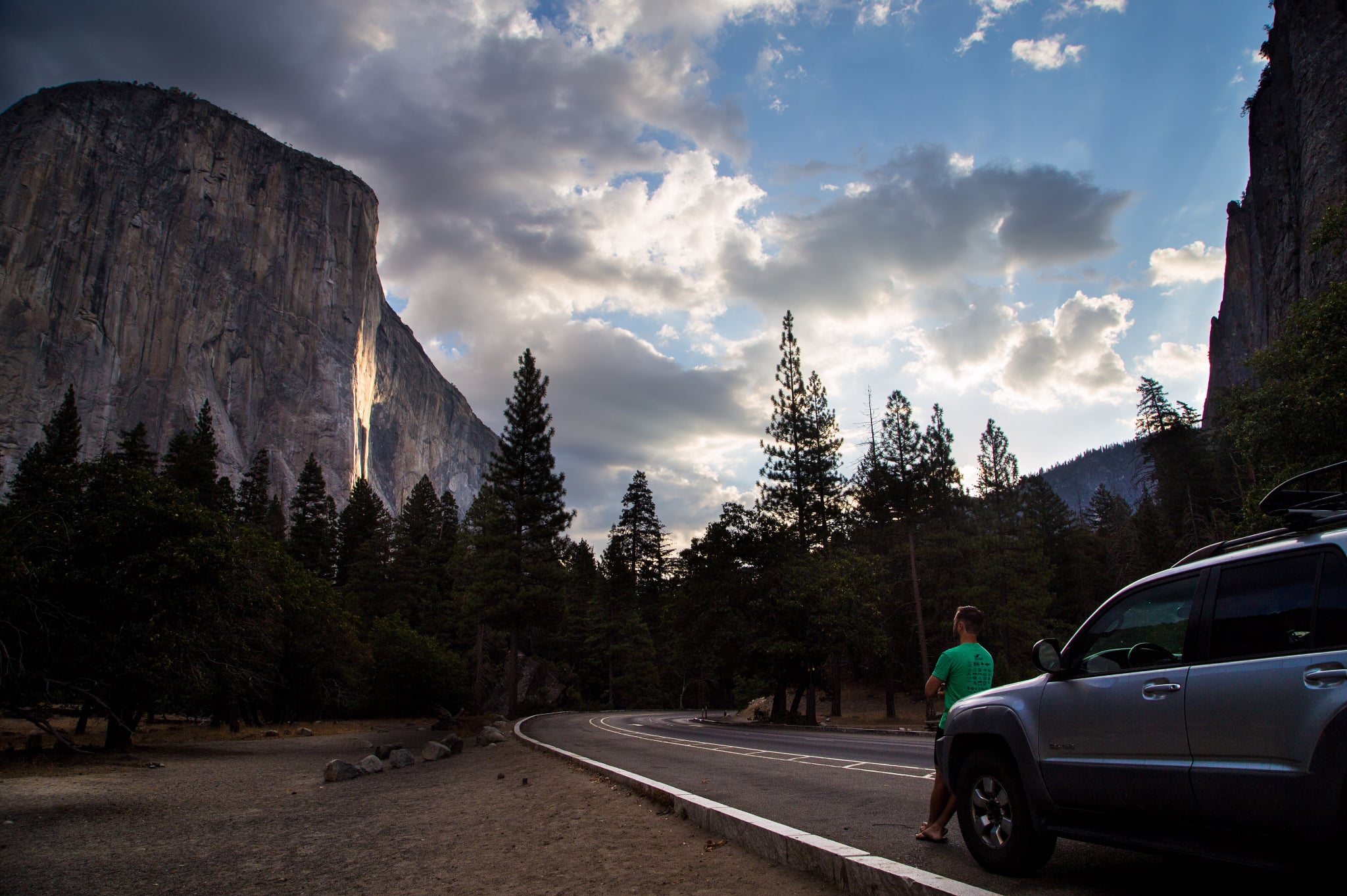
Not just a great valley, but a shrine to human foresight, the strength of granite, the power of glaciers, the persistence of life, and the tranquility of the High Sierra. First protected in 1864, Yosemite National Park is best known for its water...
This fee is valid for seven consecutive days for a non-commercial car, pickup truck, RV, or van with 15 or fewer passenger seats. This fee covers the vehicle and everyone inside of it.
Entrance - Motorcycle
$30.00
This fee is valid for seven consecutive days for a non-commercial motorcycle (cost is per motorcycle, not person).
Entrance - Per Person
$20.00
This fee is valid for seven consecutive days for people entering on foot, a bicycle, a horse, or a non-commercial bus or van. People 15 years and younger are free.
Commercial Entrance - Sedan
$25.00
The fee is $25 plus $20 per person, not to exceed $105. This fee is valid for seven consecutive days. A commercial use authorization is required.
Commercial Entrance - Van
$125.00
This fee is valid for seven consecutive days. A commercial use authorization is required.
Commercial Entrance - Mini-bus
$200.00
This fee is valid for seven consecutive days. A commercial use authorization is required.
Commercial Entrance - Motor Coach
$300.00
This fee is valid for seven consecutive days. A commercial use authorization is required.
Entrance - Non-commercial Groups
$300.00
The per-person fee is $20 to a maximum of $300 per vehicle. People 15 years and younger are free.
Entrance - Education/Academic Groups
$0.00
An educational fee waiver is available for educational and scientific groups that are accredited or tax-exempt for educational purposes planning a trip for educational or scientific purposes related to Yosemite that is not primarily recreational.
Commercial Entrance - Per Person
$20.00
The fee is $25 plus $20 per person, not to exceed $105. This fee is valid for seven consecutive days. A commercial use authorization is required.
During the campground's open season (approximately mid-July through early September) reservations are required. Reservations are required for all sites, including the horse sites (3) and group sites (2). Campground reservations are released two weeks in advance on a rolling daily window (i.e., 14 days in advance of arrival date) at 7 am Pacific time. Be aware that nearly all campground reservations in Yosemite for the months of May through September and for some other weekends are filled the first day they become available, usually within seconds or minutes after 7 am Pacific time.
Camp 4 is open all year. Sites are shared, with up to 6 people per site. In 2025, from April 18 to November 15, reservations are required and available one week in advance of your arrival date. Up to six people can be registered for a site per each reservation transaction. For part of the year, the campground is open on a first-come, first-served basis and visitors self-register for a site upon arrival. A ranger may be onsite to help register campers. Space is available on a per-person basis and you can register/reserve for up to the maximum stay limit.
Reservations are required when Crane Flat is open (approximately July through mid-October). Campground reservations are released two weeks in advance on a rolling daily window (i.e., 14 days in advance of arrival date) at 7 am Pacific time. Be aware that nearly all campground reservations in Yosemite for the months of May through September and for some other weekends are filled the first day they become available, usually within seconds or minutes after 7 am Pacific time.
Reservations are required from April 15 through October 5, 2025. During the rest of the year, the entire campground (other than the group sites, which close) are available on a first-come, first-served basis. Campground reservations are available in blocks of one month at a time, up to five months in advance, on the 15th of each month at 7 am Pacific time. Be aware that nearly all campground reservations in Yosemite for the months of May through September and for some other weekends are filled the first day they become available, usually within seconds or minutes after 7 am Pacific time.
Reservations are required seasonally when Lower Pines is open (mid-April through late October). Campground reservations are available in blocks of one month at a time, up to five months in advance, on the 15th of each month at 7 am Pacific time. Be aware that nearly all campground reservations in Yosemite for the months of May through September and for some other weekends are filled the first day they become available, usually within seconds or minutes after 7 am Pacific time.
North Pines Campground reservations are available by early access lottery; any available reservations after the lottery are available up to five months in advance starting February 15. Successful lottery applicants will have an opportunity to make a reservation for campsites in North Pines Campground during an early access period. Reservations are required seasonally for North Pines when it is open (early April through late October). After the early access period, remaining campground reservations are available in blocks of one month at a time, up to five months in advance, on the 15th of each month at 7 am Pacific time. Be aware that nearly all campground reservations in Yosemite for the months of May through September and for some other weekends are filled the first day they become available, usually within seconds or minutes after 7 am Pacific time.
During the campground's open season (approximately mid-July through mid-October), reservations are required. Campground reservations are released two weeks in advance on a rolling daily window (i.e., 14 days in advance of arrival date) at 7 am Pacific time. Be aware that nearly all campground reservations in Yosemite for the months of May through September and for some other weekends are filled the first day they become available, usually within seconds or minutes after 7 am Pacific time.
During the campground's open season (approximately mid- to late June - mid-October), 52 sites will be available by reservation only. Campground reservations are released two weeks in advance on a rolling daily window (i.e., 14 days in advance of arrival date) at 7 am Pacific time. Be aware that nearly all campground reservations in Yosemite for the months of May through September and for some other weekends are filled the first day they become available, usually within seconds or minutes after 7 am Pacific time.
Typically, during the campground's open season (approx. July - September), all sites are available by reservation. About half the campsites are available in blocks of one month at a time, up to two months in advance, on the 15th of each month at 7 am Pacific time. The other half of campsites are available two weeks in advance on a daily rolling window (i.e., 14 days in advance) at 7 am Pacific time. Be aware that nearly all campground reservations in Yosemite for the months of May through September and for some other weekends are filled the first day they become available, usually within seconds or minutes after 7 am Pacific time.
Typically, during the campground's open season (approx. July - September), all sites are available by reservation. About half the campsites are available in blocks of one month at a time, up to two months in advance, on the 15th of each month at 7 am Pacific time. The other half of campsites are available two weeks in advance on a daily rolling window (i.e., 14 days in advance) at 7 am Pacific time. Be aware that nearly all campground reservations in Yosemite for the months of May through September and for some other weekends are filled the first day they become available, usually within seconds or minutes after 7 am Pacific time.
Reservations are required all year for Upper Pines. Campground reservations are available in blocks of one month at a time, up to five months in advance, on the 15th of each month at 7 am Pacific time. Be aware that nearly all campground reservations in Yosemite for the months of May through September and for some other weekends are filled the first day they become available, usually within seconds or minutes after 7 am Pacific time.
Reservations are required in 2025 from April 15 through October 26. During the rest of the year, Loop A is available on a first-come, first-served basis. Loops B and C are closed in winter. The group site is available by reservation only year-round. Campground reservations are available in blocks of one month at a time, up to five months in advance, on the 15th of each month at 7 am Pacific time. Be aware that nearly all campground reservations in Yosemite for the months of May through September and for some other weekends are filled the first day they become available, usually within seconds or minutes after 7 am Pacific time.
Wawona Horse Camp reservations are required from early to mid-April through early to mid-October. During the rest of the year the campground is closed. Campground reservations are available in blocks of one month at a time, up to five months in advance, on the 15th of each month at 7 am Pacific time.
During the campground's open season (approximately July - September), a reservation is required. Campground reservations are released two weeks in advance on a rolling daily window (i.e., 14 days in advance of arrival date) at 7 am Pacific time. Be aware that nearly all campground reservations in Yosemite for the months of May through September and for some other weekends are filled the first day they become available, usually within seconds or minutes after 7 am Pacific time.
During the campground's open season (approximately mid-July through early September), reservations are required. Campground reservations are released two weeks in advance on a rolling daily window (i.e., 14 days in advance of arrival date) at 7 am Pacific time. Be aware that nearly all campground reservations in Yosemite for the months of May through September and for some other weekends are filled the first day they become available, usually within seconds or minutes after 7 am Pacific time.
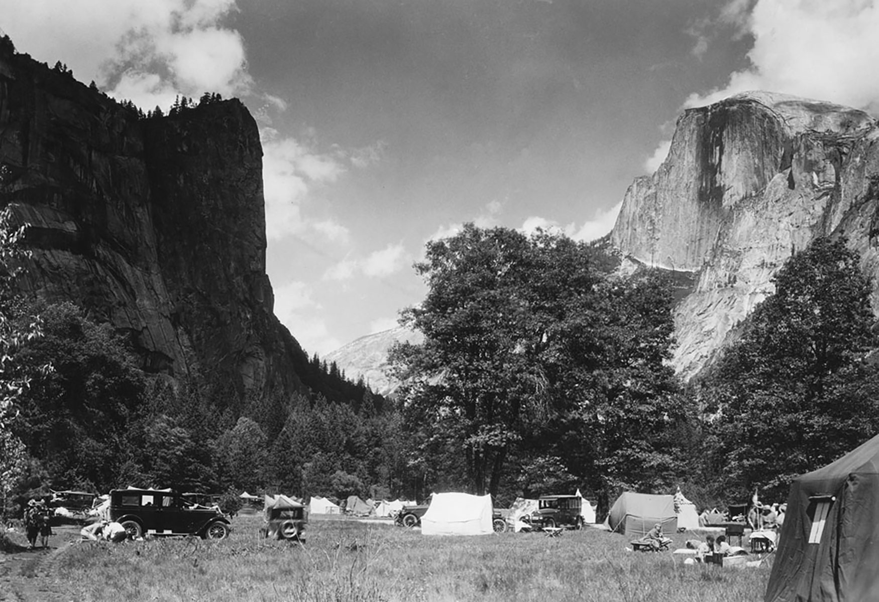
Although Yosemite was set aside as a national park in 1890, the National Park Service had not yet been created. Following the precedent set in Yellowstone, our country's first national park, the U.S. Army Cavalry also patrolled General Grant National Park (now known as Kings Canyon National Park) and Yosemite National Park. Each summer over 200 soldiers, usually cavalry, rode from the Presidio of San Francisco to protect both parks.
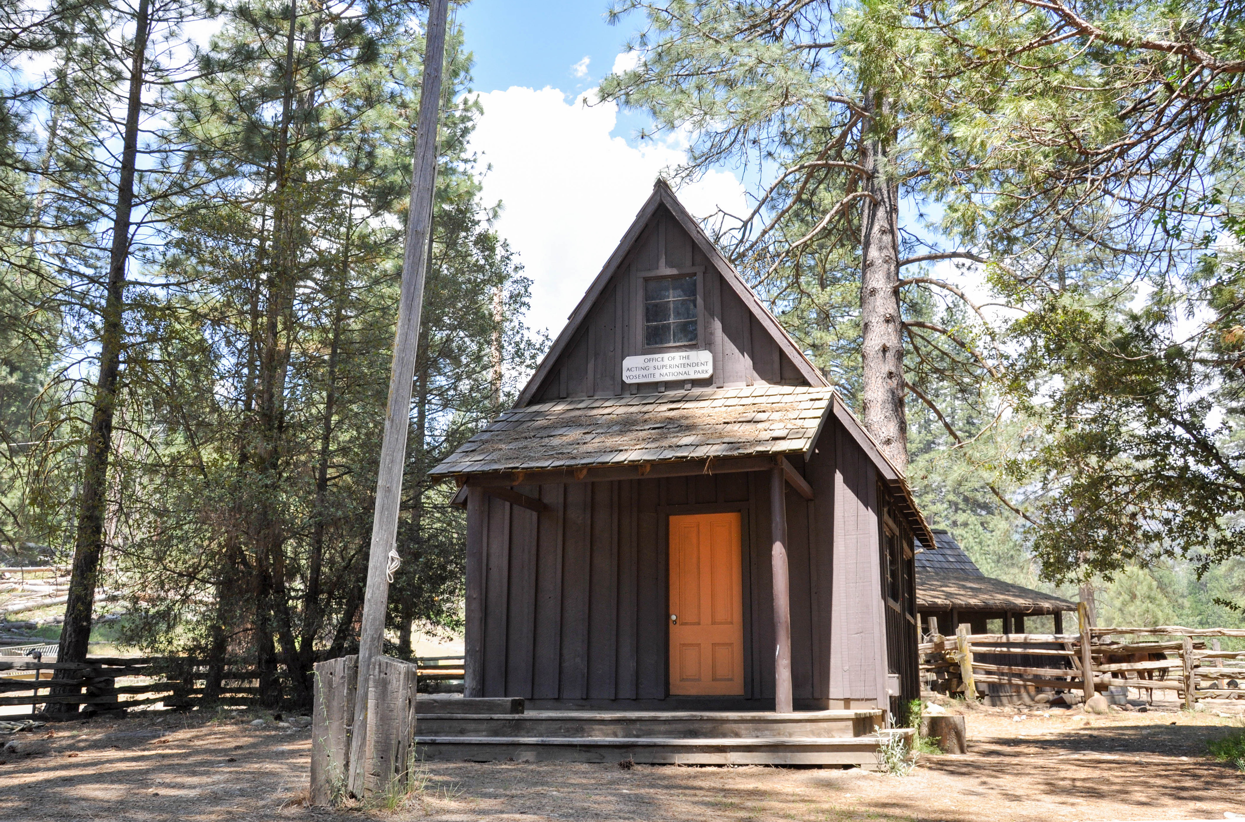
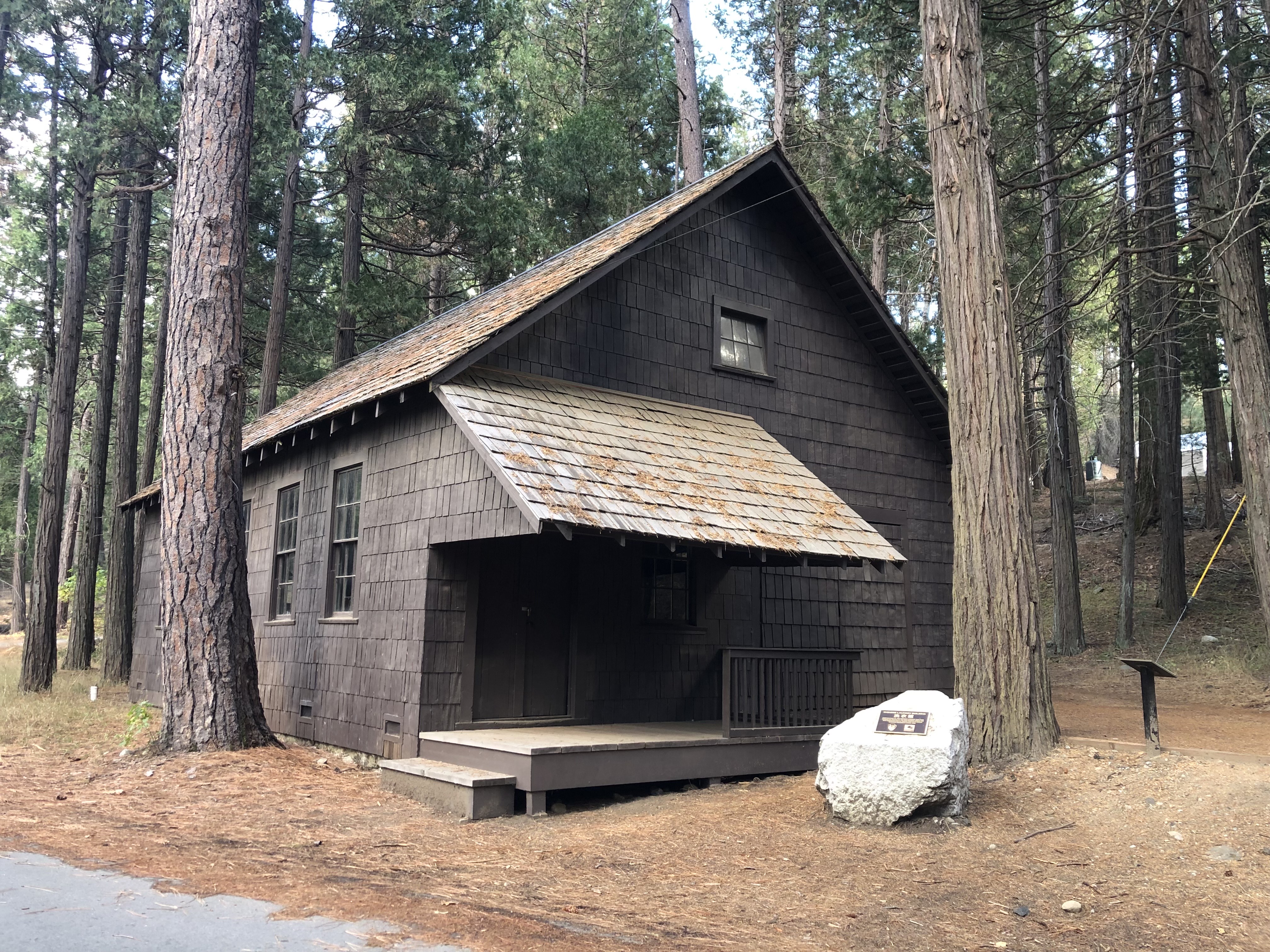
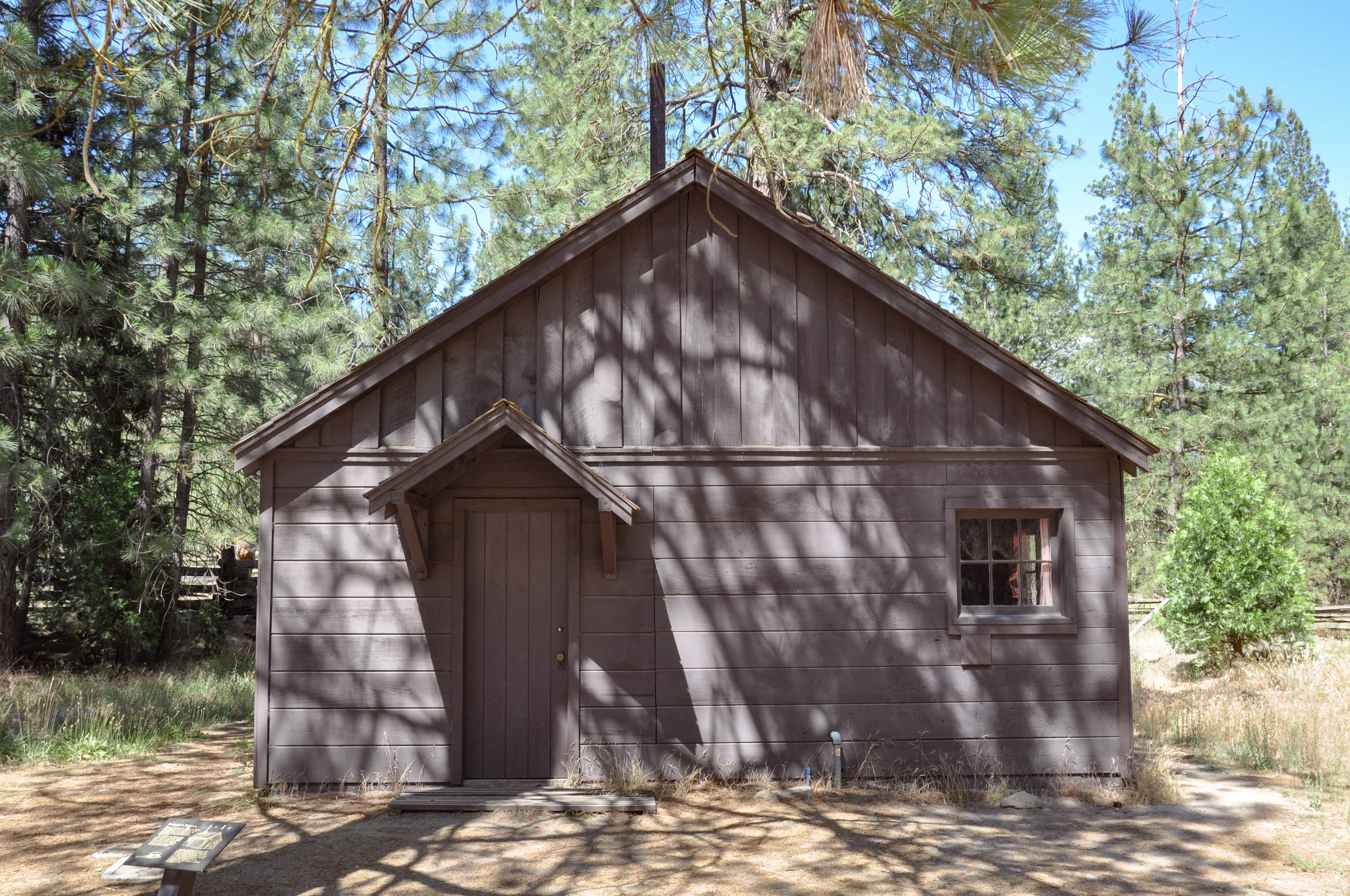
This small A-frame wooden cabin has an orange door located left of center. There is a cement patio and a shingled porch roof, slanting downward from the building, held up by two wooden posts. A single window sits above the porch and a smoke stack off the left side of the roof. Between the porch roof and the window is a black and white sign that reads: Office of the Acting Superintendent, Yosemite National Park. A flagpole waving the American flag and picnic table are in front of this structure. An exhibit sign reads: On October 1, 1890, a national preserve of 932,600 acres was established, surrounding Yosemite Valley and the Mariposa Grove of Giant Sequoias. Between 1891 and 1913, cavalry troops from the Presidio in San Francisco spent the summer months here to protect and administer the area. After several seasons, they succeeded in abating sheep herding in the delicate high country meadows. The troops built miles of high Sierra trails for patrol purposes, trails suitable for visitors as well. In addition, they dealt with wildfires, poachers and lost travelers. This particular building was erected in Wawona as headquarters for the commanding officer who acted as superintendent of the Park. From here, troops visited the big trees, patrolled the high country and stocked lakes and streams with trout to provide fine angling.
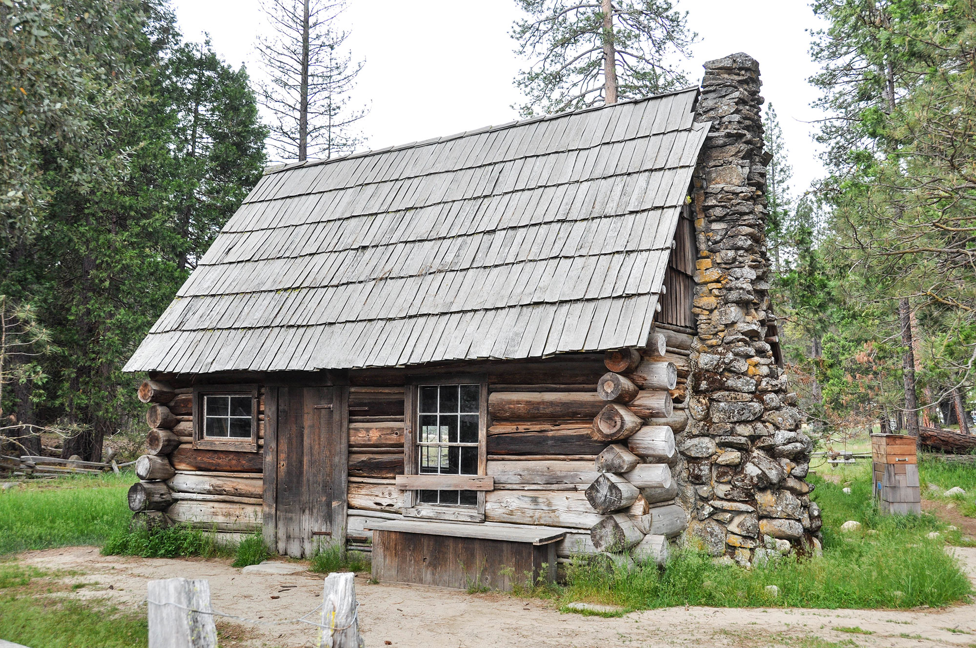
Tourist parties provided business for local residents. George Anderson, a miner and blacksmith, worked as a guide in the late 1800s, and escorted visitors on expeditions in Yosemite. In 1875, he was the first person to climb Half Dome. He spent his winters in this building at Big Meadow (now called Foresta), and his summers in Yosemite Valley.
This small log cabin has a steep roof, with rows of vertical shingles. it has a door made of vertical wooden planks, set left of center, with a larger window to its right and a small window to its left. A stone chimney rises up along the right sight of the structure. An exhibit sign reads: Mountaineer Artists' paintings excited the curiosity of folks, and interest in the area grew rapidly. In 1864, the Yosemite Valley and Mariposa Grove of Giant Sequoias were granted to California as a public trust. At first, travel into these areas was only on foot or horseback. But soon, nationwide and local improvements in transportation, such as the transcontinental railroad (1869) and stage roads into Yosemite Valley (1874), made travel more practical. Men such as Scots emigrant George Anderson proved many of these visitors needs, serving as blacksmiths, cooks, and trail guides. Anderson himself built many of the trails still used in the Valley area. In October, 1875, he succeeded in scaling the back side of Half Dome, and visitors used his rope for several years thereafter to make their own ascents. Anderson used this floorless cabin as his residence at Big Meadow, northwest of Yosemite Valley, when not working elsewhere in the area.
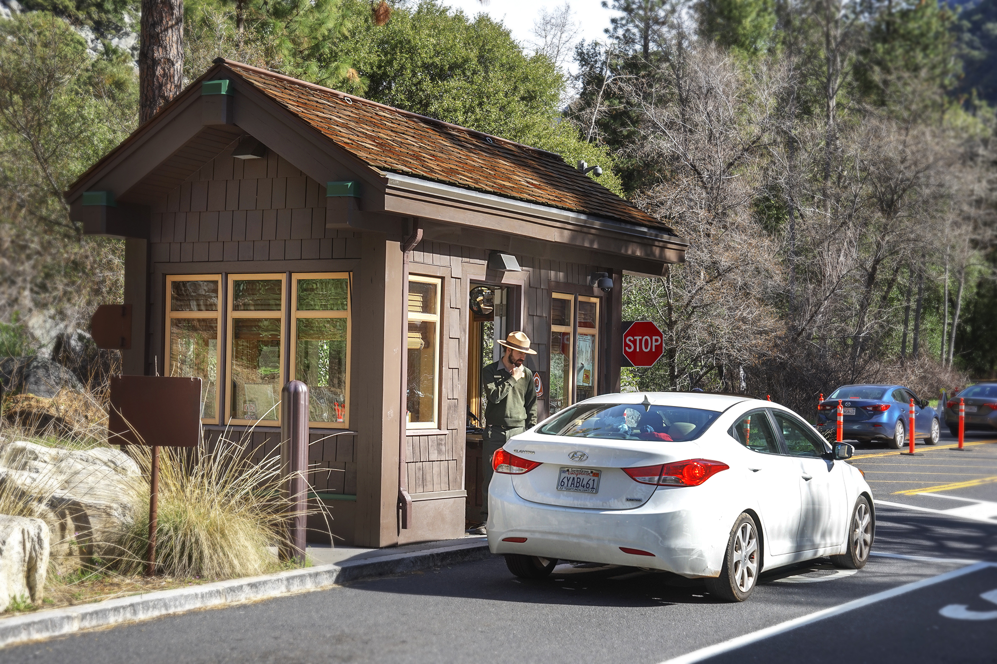
Welcome to Yosemite National Park! Prepare to let your curiosity guide you to new places. Pick up a map and brochure as you enter your national park. A unique natural feature welcomes visitors to the park, via the Arch Rock entrance. Two house-sized boulders, situated on either side of the inbound road, form an archway for visitors to pass through. It's a truly exceptional experience upon first entering Yosemite National Park. The park entrance fee can be paid upon arrival.
As you approach the entrance station, a ranger-managed booth sits in the middle of the road. There are two lanes on each side of the booth. As you drive away from the booth, the two lanes merge into one lane each for inbound and outbound traffic. The American flag waves during business hours. <br /><br />Just past the ranger-managed booth, on the inbound single lane into Yosemite, two house-sized boulders, situated on either side of the road, form an archway for vehicles to pass through. This can be a tight squeeze for oversized RVs or commercial buses.
Explorers, writers, and early tourist parties of the 1850s returned from Yosemite with stories of spectacular beauty. Artists were drawn to Yosemite, where they found inspiration in the magnificent scenery. Paintings, drawings, sketches, and photographs publicized and popularized Yosemite. Consequently, many people chose to travel the arduous route to Yosemite and experience the beauty firsthand. Thus, artists played a key role in increased awareness, tourism, and protection.
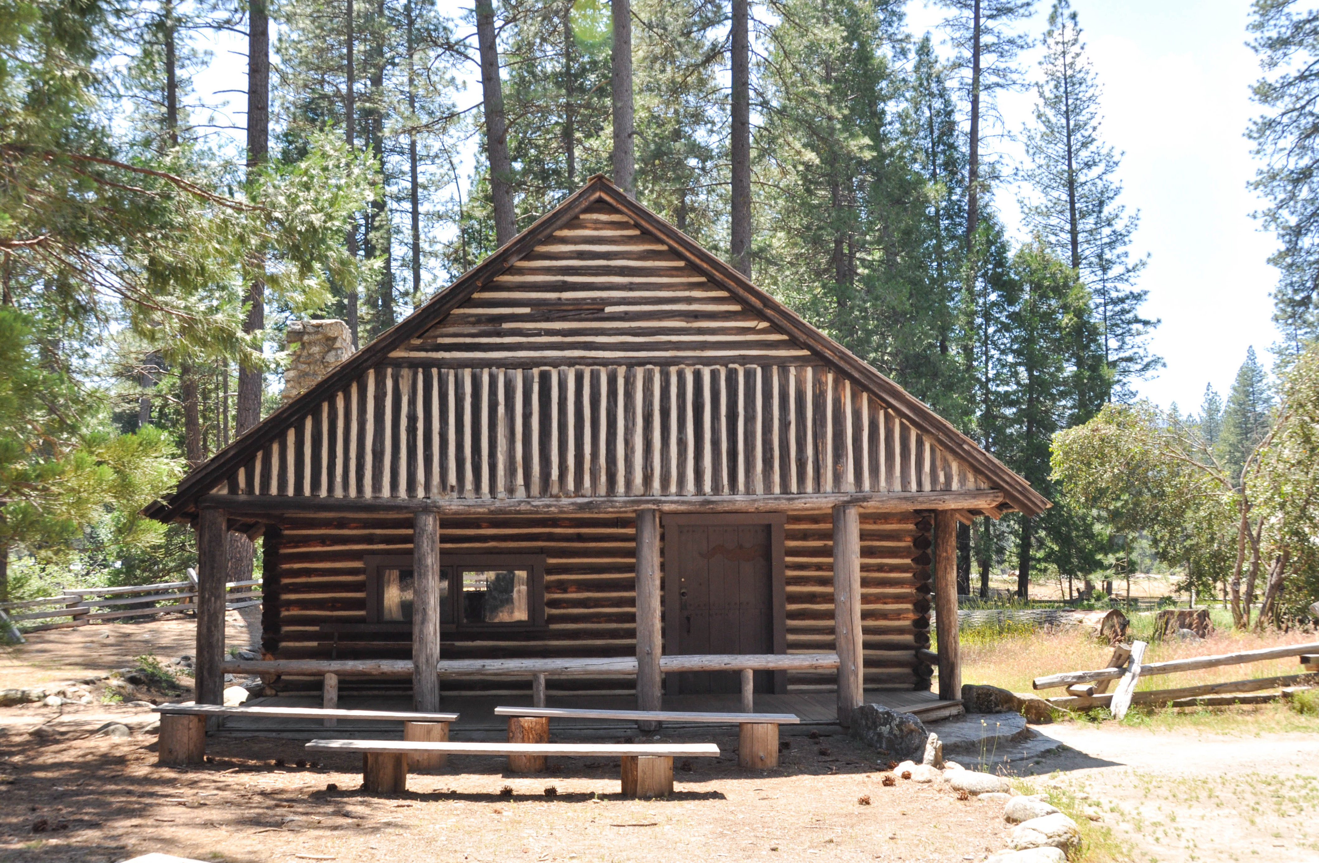
This log cabin has horizontal logs, filled with white cement, making up the base of the structure. A large A-frame roof sits atop the base, consisting of horizontal and vertical logs, filled with white cement. There is a brown door near the right side and one rectangular window to the left. There is a covered front porch. An exhibit sign reads: Artist's Cabin - Artists were among the first pioneers to enjoy and appreciate this area for the sake of its natural beauty and grandeur. It is they who brought to public attention the magnificence of 30-foot wide trees and 1,000-foot waterfalls, instilling a sense of wonder in those who had never seen the Yo-Semite. The era of the artist in Yosemite extends form 1855 to the present time. This cabin was built in Yosemite Valley around 1900, on the bank of the Merced River near Sentinel Bridge. It served as the home of artist Chris Jorgensen. Jorgensen maintained a studio nearby, and specialized in scenics. He was one of many artists who popularized Yosemite.
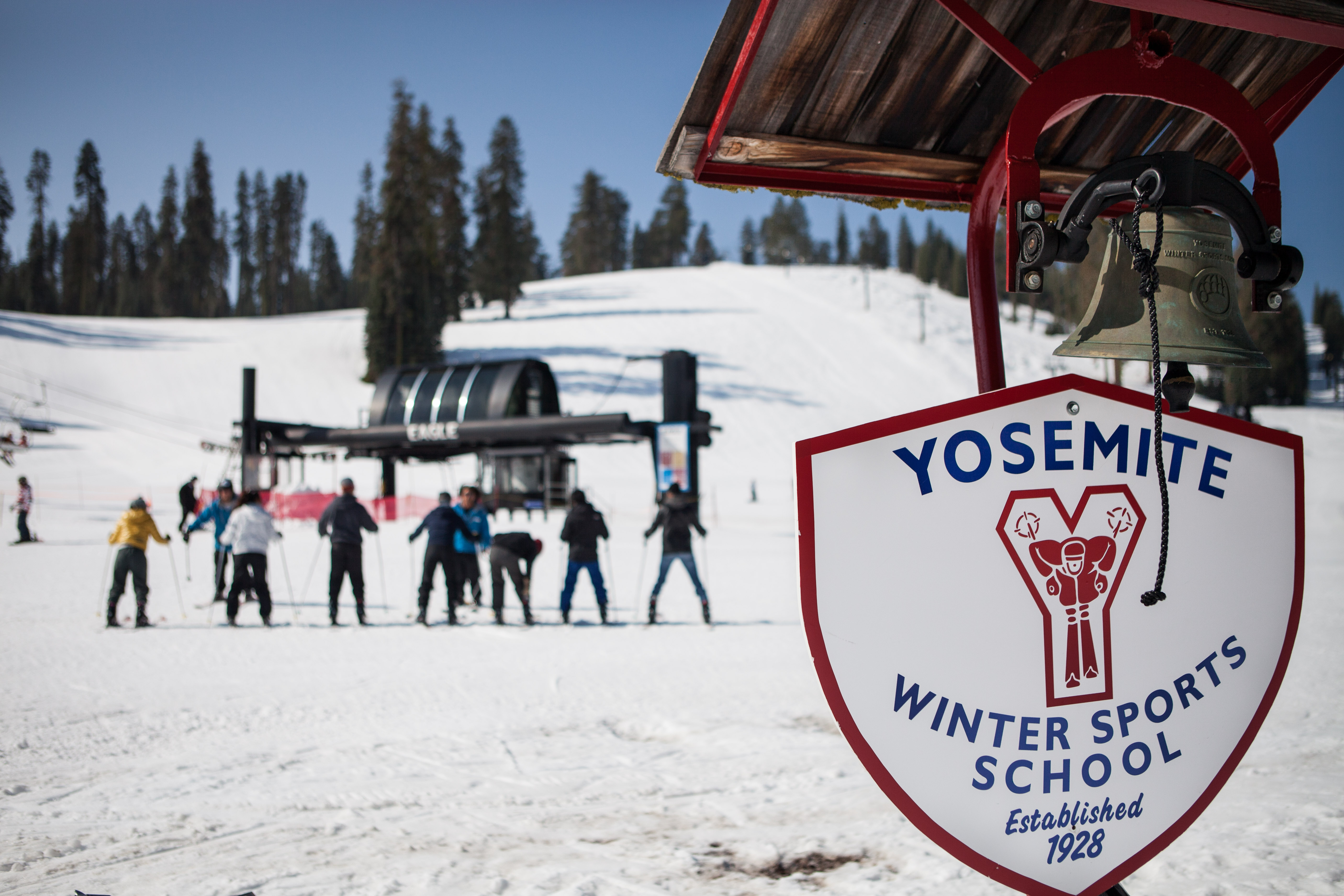
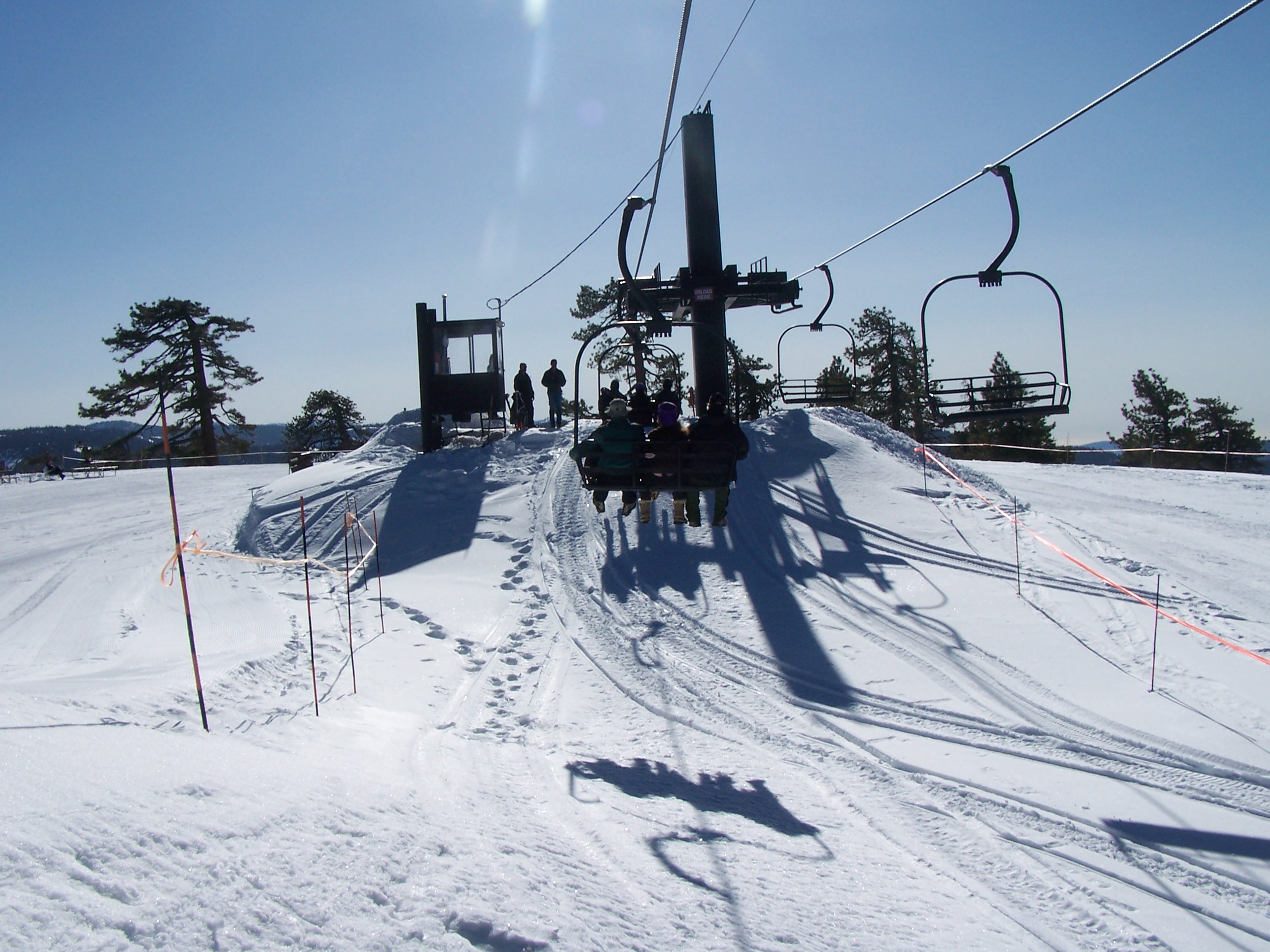
Since opening in 1935, Badger Pass Ski Area has been a favorite ski destination for families and Yosemite enthusiasts. The ski area boasts fewer crowds and fun winter activities including skiing, snowshoeing, snowboarding, cross-country skiing, and snow tubing. The ski area is accessible by vehicle or via free shuttle bus from Yosemite Valley.
Upon entering the Badger Pass Ski Area, ski slopes and chairlifts can immediately be seen in the distance. Driving further onto the property, parking spots start to become available on both sides of the road before approaching the main ski lodge, which is on the right. The ski lodge is a two-story building and has two dining areas, an activity's desk, a sports shop, locker rooms, and alpine rental shop. On the back side of the ski lodge are several ski slopes, differing in grade and difficulty level, a few chairlifts, and an A-frame ranger station. Back in front of the ski lodge, the road continues past a Nordic ski center on the left, which is in a brown trailer, before circling around into a large parking area. Some parking spaces are labeled for overnight parking only, and requires a wilderness permit. All other parking spots are available to all visitors. The road eventually loops back around to the ski lodge area, with the option to turn right to exit the premises and meet up with the Tioga Road.
Welcome to Yosemite National Park! Prepare to let your curiosity guide you to new places. Pick up a map and brochure as you enter your national park. The park entrance fee can be paid upon arrival. Park passes can be purchased here, and park brochures are available.
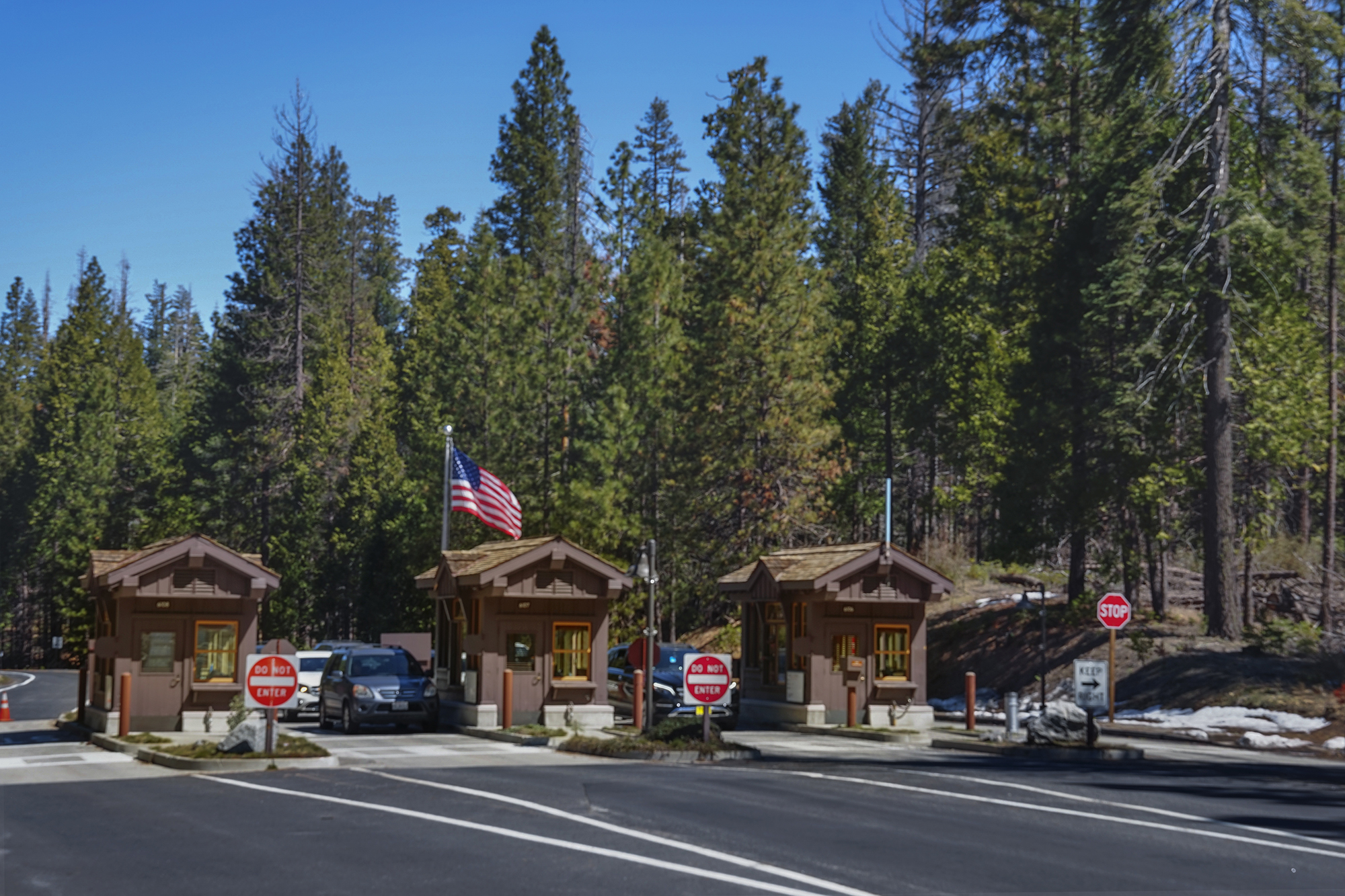
The one lane approach to the Big Oak Flat Entrance splits into three inbound lanes. Three small wooden kiosks are situated between each lane. The last lane on the left is the only outbound lane. The National Park Service logo is placed above the windows on each kiosk. The logo consists of a downward pointing arrowhead, a sequoia tree, a mountain range, a lake, a bison, and text that reads National Park Service. A flag pole waving the American Flag is located in front of the middle kiosk. A sign in front of the far right kiosks reads, Credit cards preferred. Yosemite National Park. <br /><br />Entrance fees (Valid for seven days with receipt), Private Vehicles are $35, Motocycles are $30, and Person (walk-in, bicyclist, organized non-commercial groups) are $20 per person. <br /><br />Annual passes include one for Yosemite National Park for $70, an Interagency Pass (valid at all 400+ federal fee areas) for $80, Interagency Senior Pass (Ages 62+ - U.S. citizens/permanent resident) for $20, Interagency Military Pass (U.S. active military and dependents) for free, and an Every Kid in Park - 4th Grade Pass (Current U.S. 4th graders with voucher) are free. <br /><br />Lifetime Passes (U.S. citizens/permanent residents) include Interagency Senior Pass (ages 62+) for $80, and the Interagency Access Pass (permanently disabled) for free.
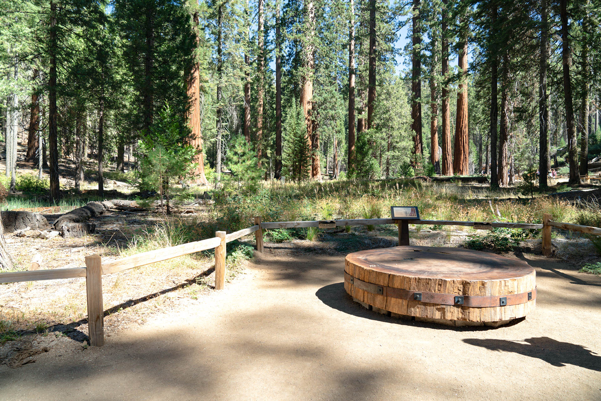
These massive trees grow bigger and live longer than almost any other living things on earth. Which of the following factors do you think is most important to their longevity? Insulating bark? Many tiny seeds? Lifelong growth? Widespread roots? Read this wayside exhibit to find out more.
This wayside exhibit is the second stop of 12 on the Big Trees Loop Tour. A wooden boardwalk with wood and metal fencing, curves outward to get a closer look at the trees. Several giant sequioas line the path ahead and make other visitors look small. Shrubs and saplings are near to the fence, while some large, mature sequoias can be seen in the distance. A wayside exhibit adhered to the wooden fence is titled, Anatomy of a Giant. Panel text reads, these massive trees grow bigger and live longer than almost any other living things on earth. Which of the following factors do you think is most important to their longevity? <br /><br />Insulating Bark - Rich with tannins and up to two feet (.61 m) thick, giant sequoia bark protects the trees from threats such as fire, insects, and disease. <br /><br />Many Tiny Seeds - Germinating from a seed no bigger than an oat flake, a mature giant sequoia can produce as many as 400,000 seeds per year. <br /><br />Lifelong Growth - Sequoias never stop growing. They are among the fastest growing trees on earth and continue adding volume throughout their lives. <br /><br />Widespread Roots - Sequoia root systems grow out, not down, and extend 100-200 feet (30-60 m) from a tree's trunk. These shallow roots can fuse with other giant sequoias in order to share resources, as opposed to competing for them. <br /><br />Bronze Tactile Relief: a section of a sequoia tree trunk is located to the immediate left of the exhibit panel. It has bumpy striations running up and down it.<br /><br />Illustration: A cross section of a sequioa tree and its roots cover the right side and bottom of the exhibit panel. Below ground, the roots are very shallow and spread throughout the bottom of the panel. Above ground, the thick tree trunk rises off the panel, before it reaches the crown. A separate illustration of a sequioa cone shows an egg shaped cone, the criss-crossing indentations. Three small, oat-like seeds fall from it.
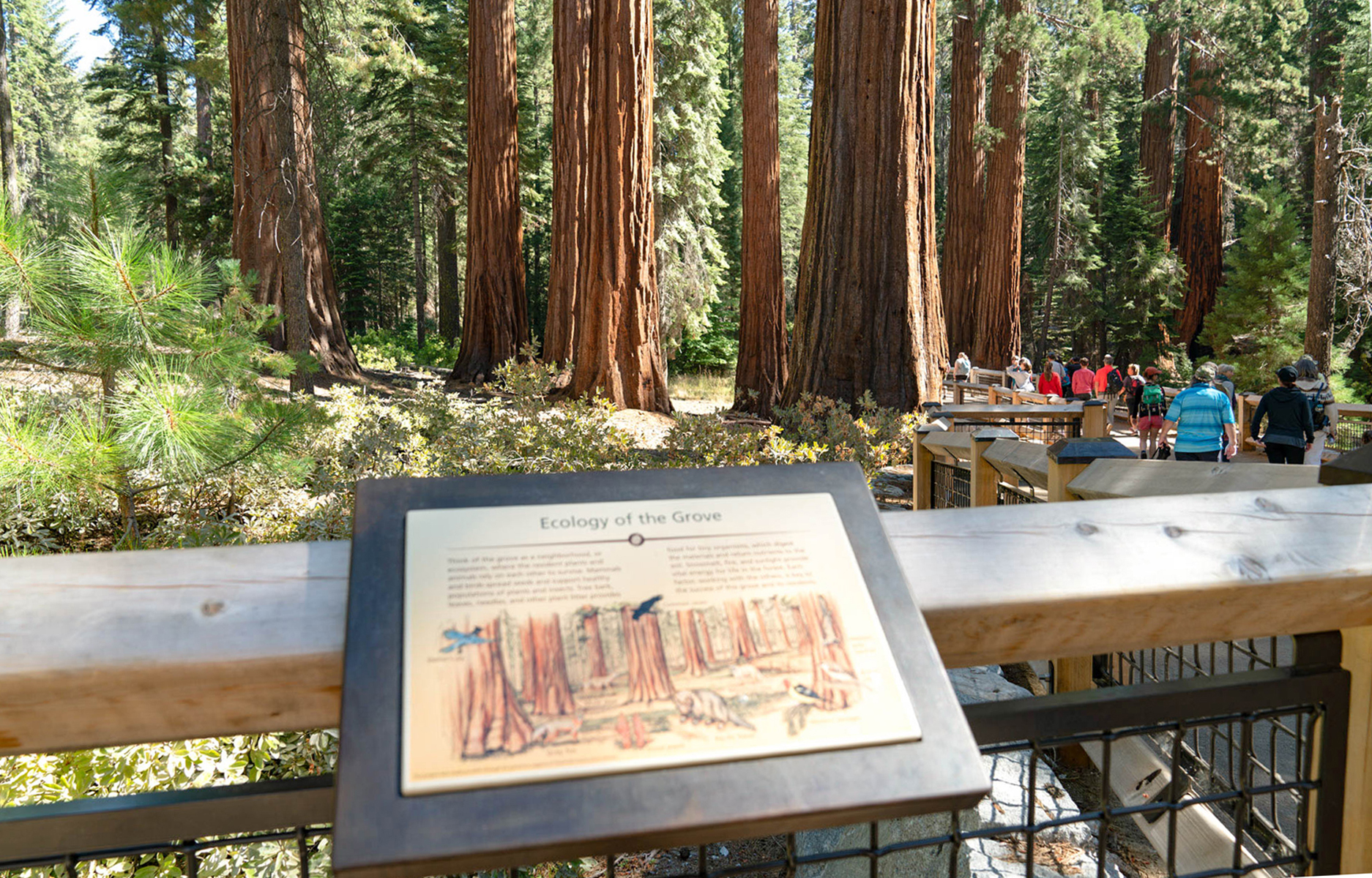
Think of the grove as a neighborhood, or ecosystem, where the resident plants and animals rely on each other to survive. Read this wayside exhibit to find out more about what roles mammals, birds, trees, snow, fire, and the sun play in this neighborhood.
This wayside exhibit is the third stop of 12 on the Big Trees Loop Tour. A wooden boardwalk with wood and metal fencing, curves outward to allow for a closer look at the trees. Several giant sequoias line the path nearby, making visitors crane their neck back to see the height of the tree. Shrubs and saplings are near the fence, while some larger, mature sequoias can be seen in the distance. A wayside exhibit adhered to the wooden fence is titled, Ecology of the Grove. Panel text reads, Think of the grove as a neighborhood, or ecosystem, where the resident plants and animals rely on each other to survive. Mammals and birds spread seeds and support healthy populations of plants and insects. Tree bark, leaves, needles, and other plant litter provides food for tiny organisms, which digest the materials and return nutrients to the soil. Snow melt, fire, and sunlight provide vital energy for life in the forest. Each factor, working with the others, is key to the success of this grove and its residents.
The ground you stand on was once asphalt, which did not give falling sequoia seeds a chance to germinate. Read about recent efforts to restore this area back to a place where giant sequoias can thrive.
This wayside exhibit is the eighth stop of 12 on the Big Trees Loop Tour. A dirt path lined with wood railings, leads to an open area filled with tall grasses and shrubs. A cross-cut of a tree trunk is to the side of the path for seating purposes. A wayside exhibit titled, Grove Restoration is next to the path. Panel text reads, the ground below you was once part of a paved road system. When sequoia seeds fell from the giants above, they landed on asphalt, with no chance of germination.<br /><br />Today, falling seeds can land on fertile, well-hydrated soil - the perfect place to start their long journey to adulthood. This change was made possible by a historic restoration effort during the years surrounding the National Park Service centennial in 2016. This effort removed asphalt, replaced roads with trails, and restored natural hydrology. Ongoing efforts such as these help to return natural processes to the grove. <br /><br />Illustration: The thin branches, sprouting from the ground, covered completely with pine-like leaves. This small sapling is next to the girth of a mature giant sequoia's reddish-brown trunk, that bulbs out at its bottom.
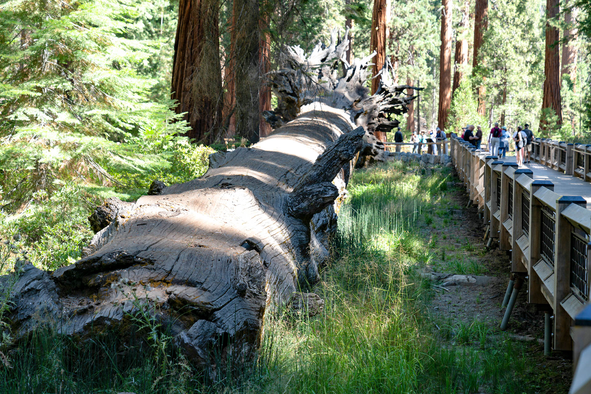
Giant sequoias can survive for thousands of years, but they are not invincible. What conditions threaten a giant sequoias survival? Read this wayside exhibit for more information.
This wayside exhibit is the seventh stop of 12 on the Big Trees Loop Tour. A wooden boardwalk with wood and metal fencing, gives a close look at two fallen trees. What is left of the roots sprawl out in all directions from the end of the sequoia trunk. Shrubs, saplings, and other plants and trees grow around the fallen trees. A long wood bench with metal armrests is along the fence. A wayside exhibit adhered to the wooden fence is titled, How Giants Fall. Panel text reads, giant sequoias can live and grow for thousands of years. They can survive lightning strikes, fires, droughts, and winter snows. They have natural defenses against insects and fungus. But they are not invincible.<br /><br />Severe, repeated fires and soil erosion can weaken the sequoias' foundations, making them vulnerable to toppling under pressure from heavy snow or high winds. <br /><br />Humans threaten the giant sequoias as well. In the early history of California, people logged thousands of sequoias, carved tunnels through trees, and created roads and trails that damaged roots and interfered with water flow. Now human-caused threats, such as air pollution, pathogens, and climate change may jeopardize the trees' long-term survival. Their future depends on how we treat the earth. <br /><br />Illustration: The large trunk of a giant sequoia tree is leaning to the right, as roots snap, and are unearthed from the ground, as if it's in the midst of falling.
Learn more about the relationship giant sequoias have had with other plants, through the ages, on this wayside exhibit.
This wayside exhibit is the tenth stop of 12 on the Big Trees Loop Tour. A dirt path lined with wood railings, transitions to a wooden boardwalk over a very wet area. Tall, green, reed-like plants, called horsetails, stand errect in this wet area along with other plants. A wayside exhibit titled, Relics of the Past, and is next to the path. Panel text reads, One of the oldest land plants, Equisetum (also called horsetail) has hollow stems that arise from a series of underground branches. Part of a primeval forest, these plants and giant sequoias have co-existed since the age of dinasours. <br /><br />Illustration: Three different kinds of plants seem to be shooting out of the ground from the same root system. The middle plant is a green, chute that has four sections, like small, thin bamboo. <br /><br />The success of these ancient forest dwellers depends on an adequate water supply, making hydrology key to survival. A sequoia's shallow, impressive root system extends to many water sources. Two to six feet beneath you, these roots stretch outward in all directions reaching for over 100 feet in order to capture this vital resource.<br /><br />Illustration: A cross-cut illustration of a tree growing, in the middle of the exhibit panel, shows the roots, below ground, shallowly spreading outward as opposed to downward.<br /><br />Caption: Due to their shallow nature, it is important to stay away from the bases of sequoias in order to avoid trampling their root systems.
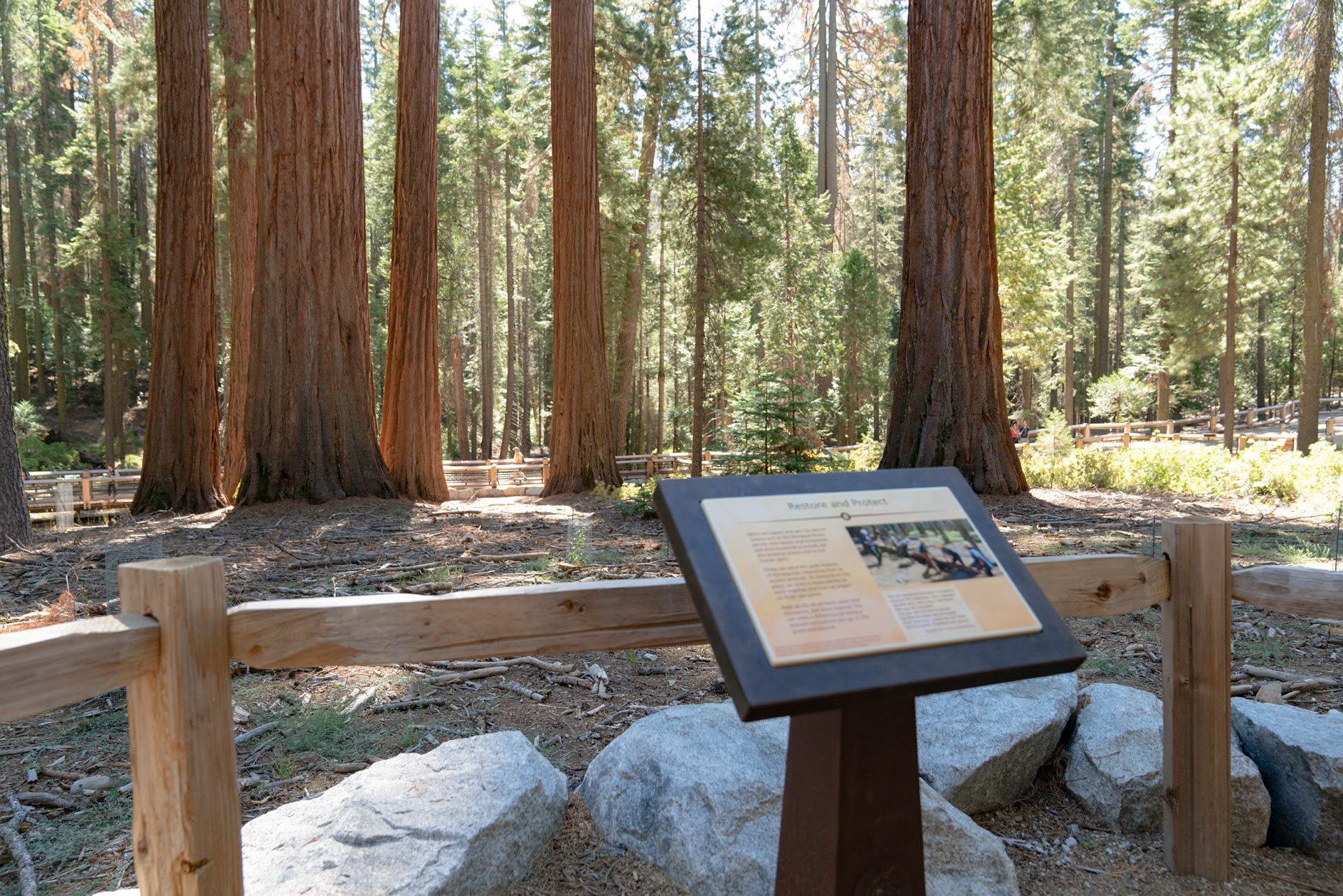
In 1864 Abraham Lincoln paused during the Civil War to set aside the Mariposa Grove and Yosemite Valley as a protected state reserve "for public use, resort, and recreation." Yosemite National Park was then established in 1890 and this grove incorporated into the park in 1906. Today, we value the quiet majesty of these giant sequoias and share a responsibility as park stewards to limit our impact on them.
This wayside exhibit is the twelvth stop of 12 on the Big Trees Loop Tour. A dirt path lined with wood railings leads to an open area that has several saplings growing, each having its own wire mesh protective tubes around it. Straight ahead, through the trees, the beginning of the loop trail can be seen. A wayside exhibit titled, Restore and Protect, is next to the path. Panel text reads, when we respect and care for natural havens such as the Mariposa Grove, we not only restore vital ecosystems and environmental processes, we also preserve places vital to the human spirit. <br /><br />Today we value the quiet majesty of the sequoias, respecting them as ancient sentinels. As stewards of this place, we share a responsibility to work together and limit our impact on these rare giants.<br /><br />Walk gently, do no harm, savor your discoveries, and leave inspired. You can make a difference by being a steward everywhere you go, in this grove and beyond. <br /><br />Photo: Ten people, men and women, wearing gloves, yellow or white hard hats, and blue t-shirts, all gather around a fallen log, ready to move it. <br /><br />Quote: Ask the questions that have no answers. Invest in the millenium. Plant sequoias. Say that your main crop is the forest that you did not plant, that you will not live to harvest. Say that the leaves are harvested when they have rotted into the mold. Call that profit. Prophesy such returns. - Excerpted from a poem by Wendell Berry.
The slender young giant sequoias around you, distinguished by their foliage of round, overlapping scales, distinctive conical profiles, and soft, spongy bark, beat great odds in finding the right conditions to sprout toward maturity. Find out what the perfect conditions are that allow a seed to become a mature giant sequoia, on this wayside exhibit.
This wayside exhibit is the sixth stop of 12 on the Big Trees Loop Tour. A wooden boardwalk with wood and metal fencing, curves outward to get a closer look young giant sequoias and saplings near the boardwalk. Shrubs and other plants and trees grow in this area. A long wood bench with metal armrests is near the center of the boardwalk, while a single-person bench with a back and arm rest is next to the fence. A wayside exhibit adhered to the wooden fence is titled, Stages of Life. Panel text reads, each tiny sequoia seed has the potential to become a mighty tree, but only few encounter the right conditions to reach maturity. The slender young sequoias around you beat great odds in finding the perfect mixture of soil moisture, temperature, and sunlight necessary to germinate and grow.<br /><br />Over the next few centuries, these slim saplings may grow to be 250-300 feet (76-91 m) tall. They will increase in volume, developing wide buttresses at their bases. Their upper limbs will expand, becoming as thick as the trunks of other trees, and their lower limbs will drop off. After they reach their full height, their crowns will become round, often with a broken (or snag) top. <br /><br />Illustration: Four trees are side by side. A small sapling, a larger cone-shaped tree, which is a young sequoia, a tall giant sequoia that has a full, round crown, and a larger giant sequioa with a snagged trunk at its top.
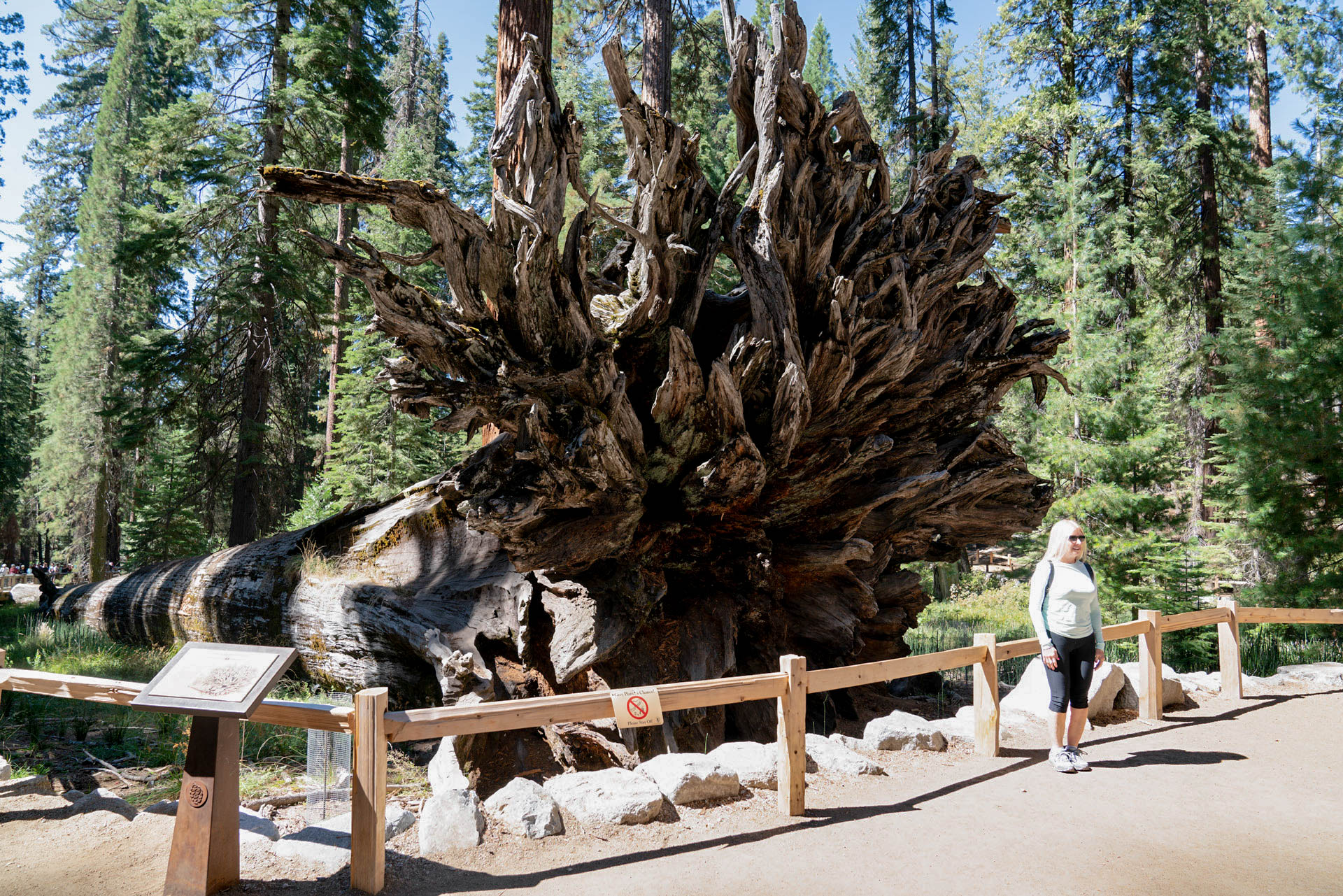
No one knows how old this tree is or when it fell. Notice the roots of this tree. Sequoias do not have deep tap roots; instead the roots spread out near the grounds' surface to capture water. While the roots are usually no deeper than six feet (2 meters), they can fan out more than 150 feet (45 meters), providing a stable base to balance the massive trunk. When visitors stay on the road and trails, it minimizes soil compaction that damages these surface roots.
This wayside exhibit is the ninth stop of 12 on the Big Trees Loop Tour. A dirt path lined with wood railings, leads to a massive giant sequoia, that is about 26 feet in diameter and over 200 feet long, laying on the ground, with its large root system exposed at its right end. The roots of the tree about are about 20 to 25 feet in height and look like a wood coral reef, with multiple branches curling and extending upward. A cross-cut of a tree trunk is nearby and used for seating purposes. A wayside exhibit titled, The Fallen Monarch is next to the path. Panel text reads, an enduring mystery, no one knows how old this tree is or when it fell. Initially encounted by the Traditionally Associated Tribes of Yosemite and later photographed with countless visitors, it remains a memorable feature of the grove.<br /><br />Although the bark and sapwood have decayed, the remaining heartwood is fortified with tannins. This natural compound protects the tree, and it may take several more centuries to decompose. <br /><br />Illustration: A fallen tree lays on the ground. The remainder of the large root system are in the forefront, sprawling in every which direction, while the trunk of the tree gets smaller as it lays toward the horizon line, away from the viewer. <br />
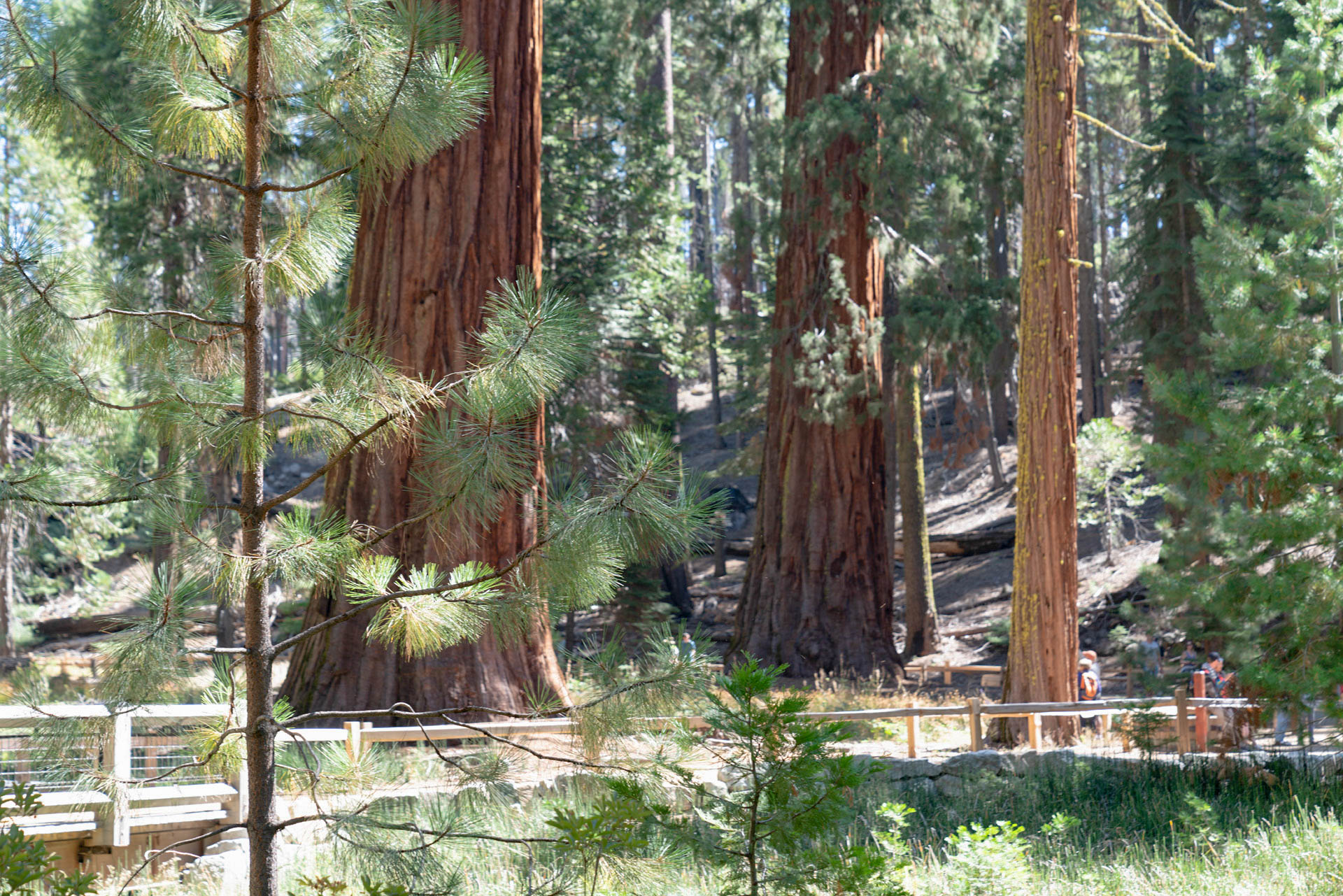
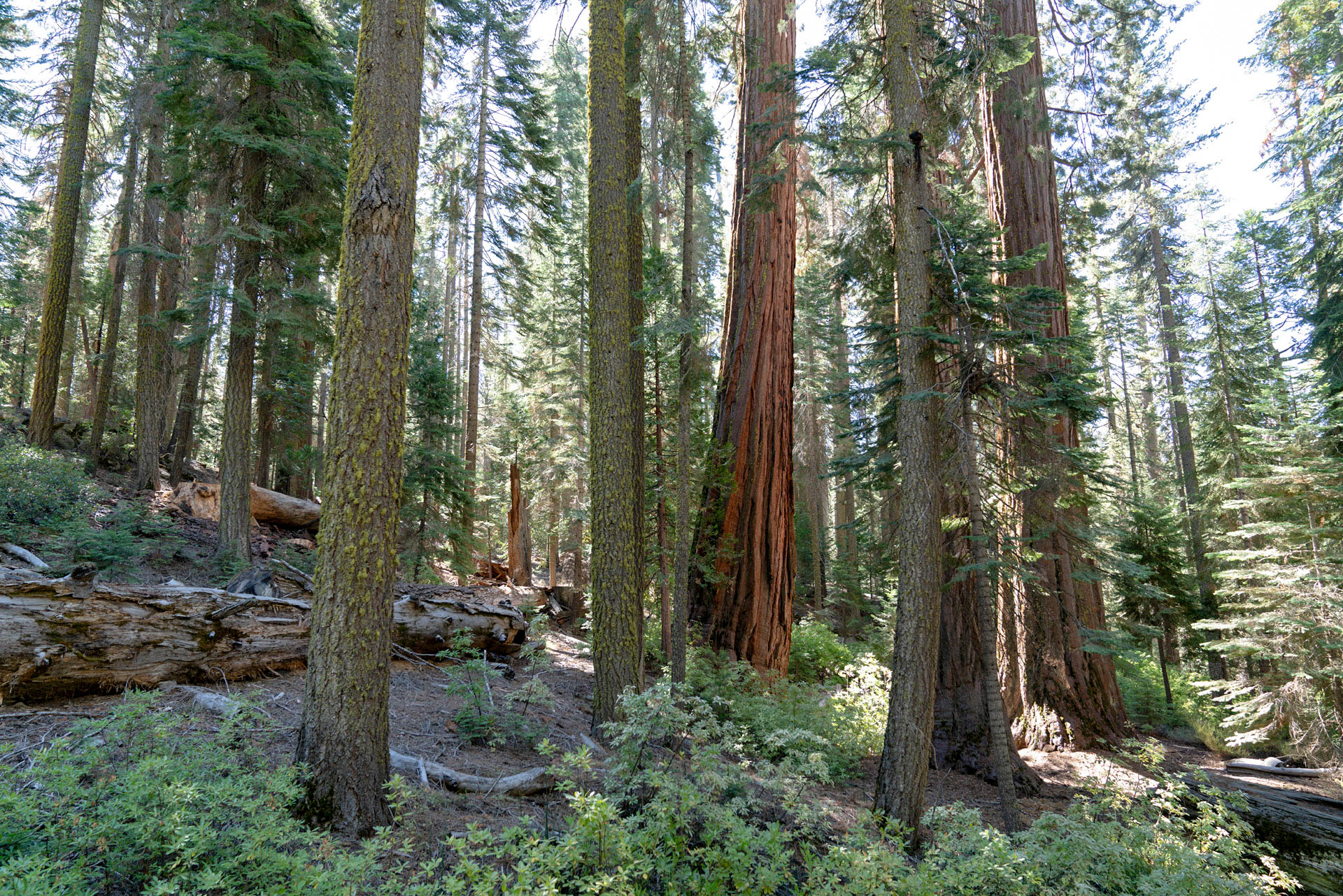
You are standing in the midst of one of Yosemite's natural and cultural treasures-and among the world's most massive living organisms. These trees, Sequoiadendron giganteum, are not the oldest living things. Although the oldest giant sequoias may exceed 3,000 years in age, some living specimens of the ancient bristlecone pine, Pinus arista, are more than 4,600 years old!
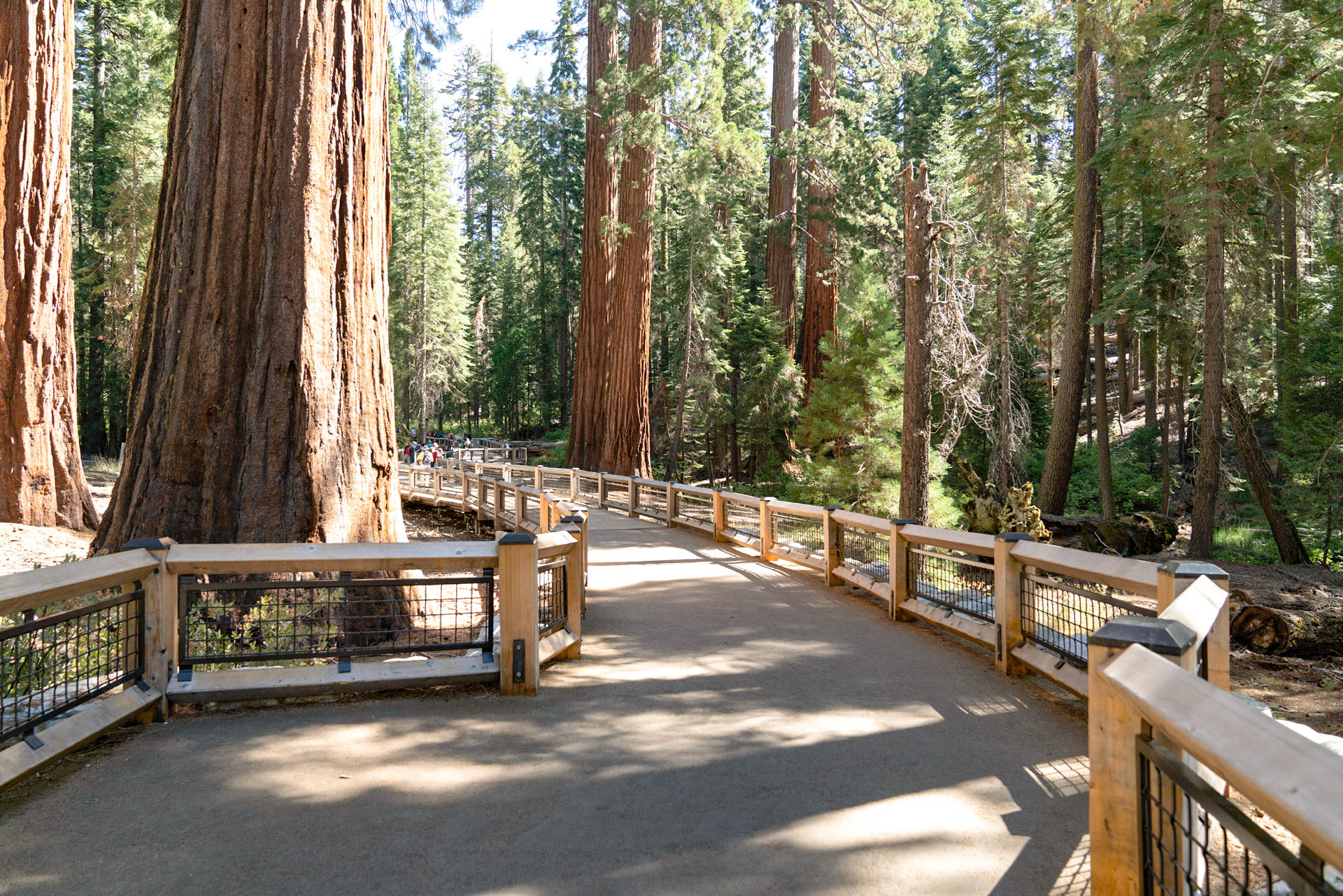
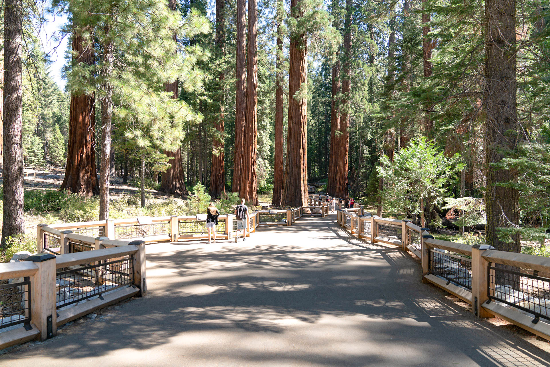
This wayside exhibit is the first stop of 12 on the Big Trees Loop Tour. A wooden boardwalk with wood and metal fencing, paves a way through the Mariposa Grove. A large log is split in two and serves as a bench, with a backside that slightly leans backward. Several giant sequioas line the path and make other visitors look small. Other trees in the grove, which include incensed cedars, ponderosa pines, and sugar pines, noticably grow among the sequoias. A wayside exhibit adhered to the wooden fence is titled, The Wonder of Sequoias. Panel text reads, you are standing in the midst of one of Yosemite's natural and cultural treasures - and among the world's most massive living organisms. <br /><br />The trees around you have stood strong for centuries. One tree in the grove, the Grizzly Giant, is estimated to be between 1,800 and 2,800 years old. Another tree in the grove is so old and large that a 128-year-old ponderosa pine is growing in its crown.<br /><br />Think of the human history these trees have witnessed over the last few thousand years. Through harsh Sierra seasons, severe fires, floods, and droughts, these ancient giants have remained ever-resilient and awe-inspiring. <br /><br />Illustration: Two trees stand side by side. The tree on the left has a full crown, thick limbs, and a broader trunk, and is labeled, giant sequoia. The tree on the right is noticably more slender and taller, with more wispier, thin branches, and is labeled coast redwood. <br /><br />Caption: The giant sequoia is the largest tree in the world by total volume; the coast redwood is the world's tallest.
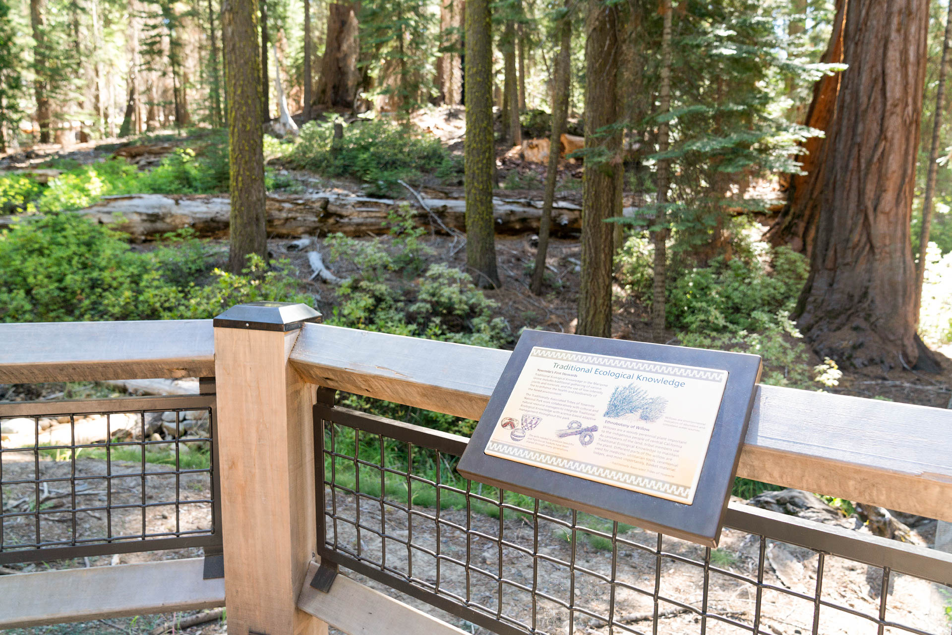
The Traditionally Associated Tribes of Yosemite National Park worked collaboratively with cultural and natural resource managers to integrate Traditional Ecological Knowledge with science-based adaptive management throughout the park. Read this wayside exhibit to see what practices were used to enhance the biodiversity of the forest environment.
This wayside exhibit is the fifth stop of 12 on the Big Trees Loop Tour. A wooden boardwalk with wood and metal fencing, curves outward to get a closer look at the giant sequoias and the wetland area that runs below the boardwalk. Shrubs, saplings, and other plants grow in this wet areas. A wood bench with metal armrests is in the area. A wayside exhibit adhered to the wooden fence is titled, Traditional Ecological Knowledge. Panel text reads, Yosemite's First Stewards - Traditional Ecological Knowledge in the Mariposa Grove includes traditional gathering of various plants and minerals, and the use of low-intensity fire to enhance the health and biodiversity of the forest environment.<br /><br />The Traditionally Associated Tribes of Yosemite National Park work collaboratively with cultural and natural resource managers to integrate Traditional Ecological Knowledge with science-based adaptive management throughout the park. <br /><br />Illustration: Three different-sized baskets with slightly different shapes have black and red indigenous designs around them. Four bunches of different kinds of natural plant materials are bunched together.<br /><br />Caption: The skills needed to produce beautiful and functional baskets have been shared through many generations. <br /><br />Ethnobotany of Willow - Willows are a woody perennial plant important to the indigenous people of central California. As caretakers of the land, tribal members use Traditional Ecological Knowledge to maintain the plant. Different parts of the willow are used for medicine, utilitarian tools, ceremonial lodges, and most importantly, basket material. <br /><br />Illustration: Slender branches with elongated leaves up and down each branch are bunched together in one plant, growing out of the ground.<br /><br />Caption: Willows are environmental indicators of abundant and consistent water sources.
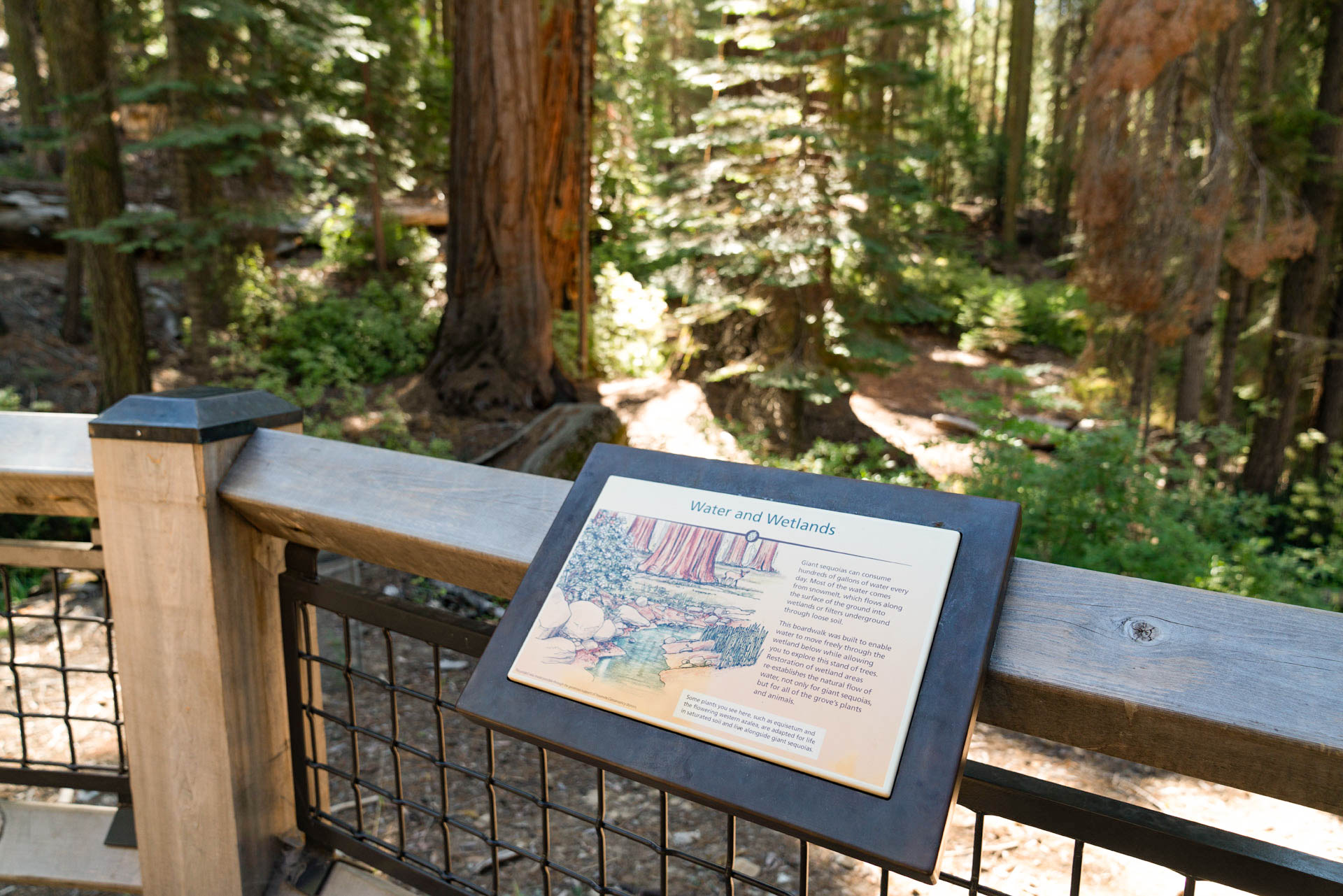
Most of these giant sequoias consume a lot of water. Where does the water come from? find out more about the importance of wetland areas to giant sequoias and other plants and animals found in the grove, on this wayside exhibit.
This wayside exhibit is the fourth stop of 12 on the Big Trees Loop Tour. A wooden boardwalk with wood and metal fencing, curves outward to get a closer look at the trees. A wood bench with metal armrests is in the area. Several giant sequioas line the path ahead and make other visitors look small. Shrubs and saplings are near to the fence, while some large, mature sequoias can be seen in the distance. A wayside exhibit adhered to the wooden fence is titled, Water and Wetlands. Panel text reads, giant sequoias can consume hundreds of gallons of water every day. Most of the water comes from snowmelt, which flows along the surface of the ground into wetlands or filters underground through loose soil. <br /><br />This boardwalk was built to enable water to move freely through the wetland below while allowing you to explore this stand of trees. Restoration of wetland areas re-establishes the natural flow of water, not only for giant sequoias, but for all of the grove's plants and animals. <br /><br />Illustration: a small, narrow stream makes its way through foliage consisting of a flowering bush and a bunch of tall, green stalks, in a sequioa grove. A deer stands near a sequioa tree, small in stature when compared to the size of the sequoia trunk.<br /><br />Caption: Some plants you see here, such as equisetum and the flowering western azalea, are adapted for life in saturated soil and live alongside giant sequoias.
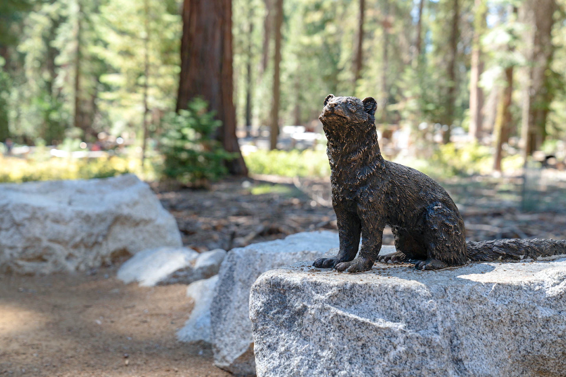
The Mariposa Grove provides a protected home for 35 species of mammals and 35 species of birds. Serious threats to Yosemite's wildlife and the ecosystems they occupy include loss of a natural fire regime, non-native species, air pollution, habitat fragmentation, and climate change. Learn about one of Yosemite's rarest species, the Pacific Fisher, on this wayside exhibit.
This wayside exhibit is the eleventh stop of 12 on the Big Trees Loop Tour. A dirt path lined with wood railings leads to an opening in the trees, a circular area that is line with boulders. In the center of the circular area is an oddly shaped outline of the canopy of a giant sequioa, inlayed into the ground with stones. To the opposite side of the circular opening is a bronze statue of a fisher, set on a stone pedastal. A wayside exhibit titled, Wildlife in the Grove, is next to the path. Panel text reads, the Mariposa Grove is home to 35 species of mammals and 35 species of birds. As humans transform landscapes worldwide, protected natural habitats are increasingly scarce and more important than ever. How many wild places still exist for wildlife where you live?<br /><br />This grove provides a protected home for several rare species, including the Pacific fisher. Scientists estimate that between 125 and 250 fishers live in Yosemite. This medium-sized weasel, a California Species of Special Concern, is an important predator that makes its home in the cavities of old-growth trees and raises 2-3 kits each year. <br /><br />Illustration: A weasel-like animal sits on a tree branch with its long tail hanging over the side. <br /><br />Caption: Even while protected in this national park, fishers face threats. Illegal use of rodenticides on public land can kill wildlife or seriously compromise their health. Many fishers are hit by vehicles. Please drive slowly to keep fishers and other animals safe.
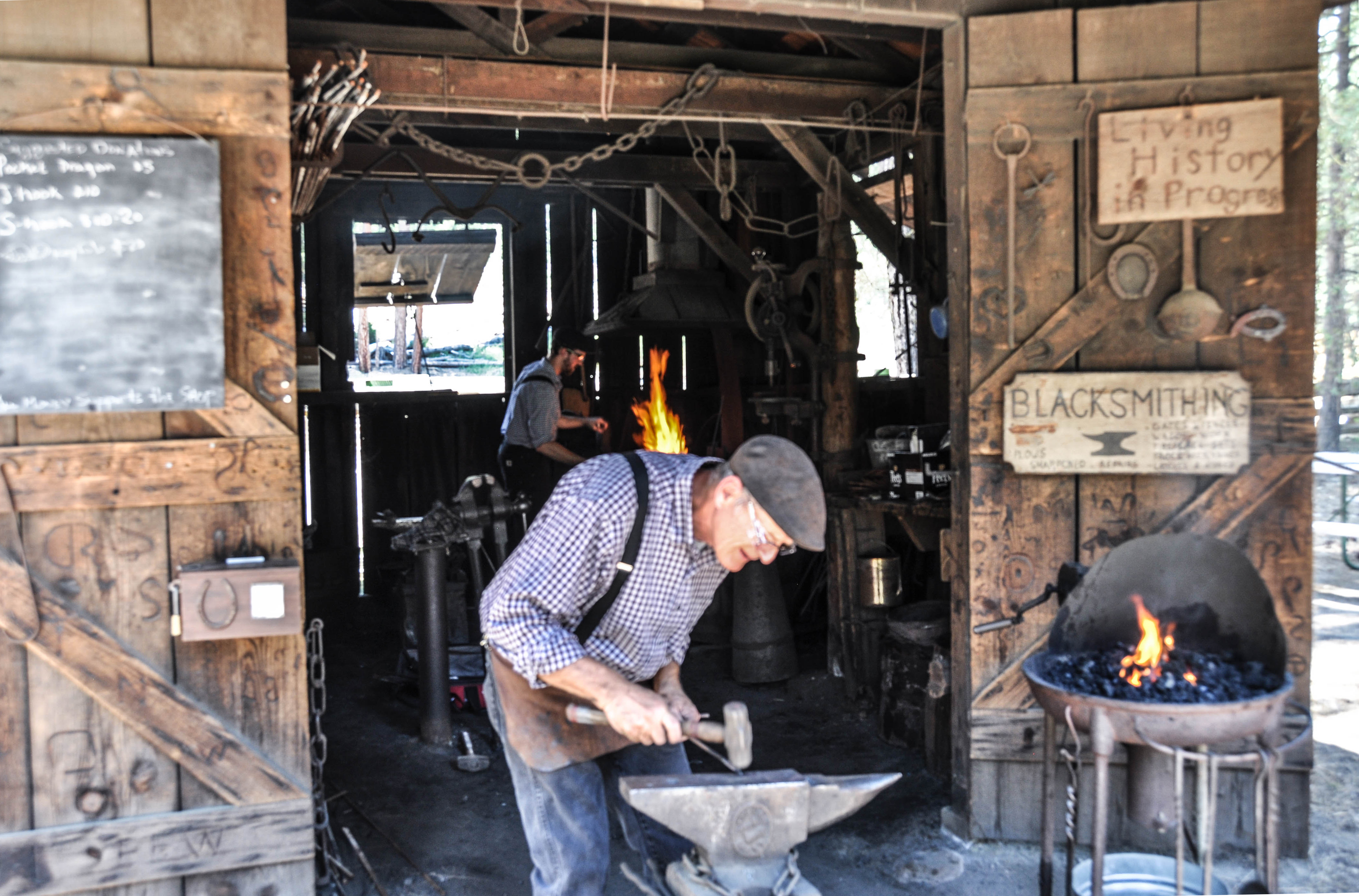
By 1900, many people had made the trip to Yosemite on horseback or by horse-drawn stage. Roads were rough on horses and riders. It took eight hours to travel approximately 25 miles from Wawona to Yosemite Valley. A four-up stage (a stage being drawn by four horses) changed horses four times during the trip. Consequently, 16 horses were used to make the journey. Blacksmiths shops were located throughout the park, and "smithys" offered valuable assistance along the roads.
This small one-room wooden structure has an A-frame roof that extends outward and is held up by two wooden posts, creating a porch-like area. The building is surrounded by dirt and dry pine needles and pine cones. There are two tree trunk stools in the front.
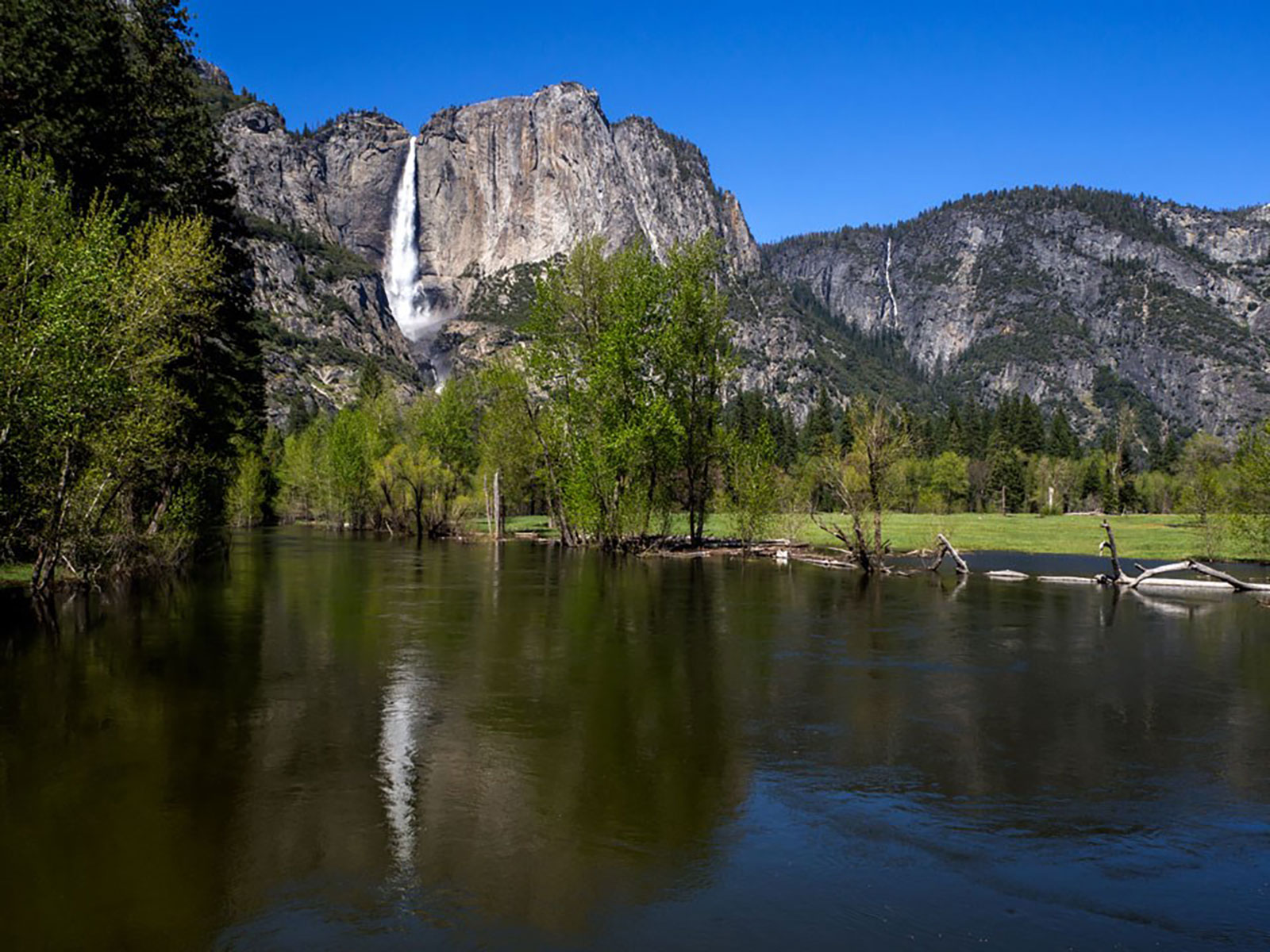
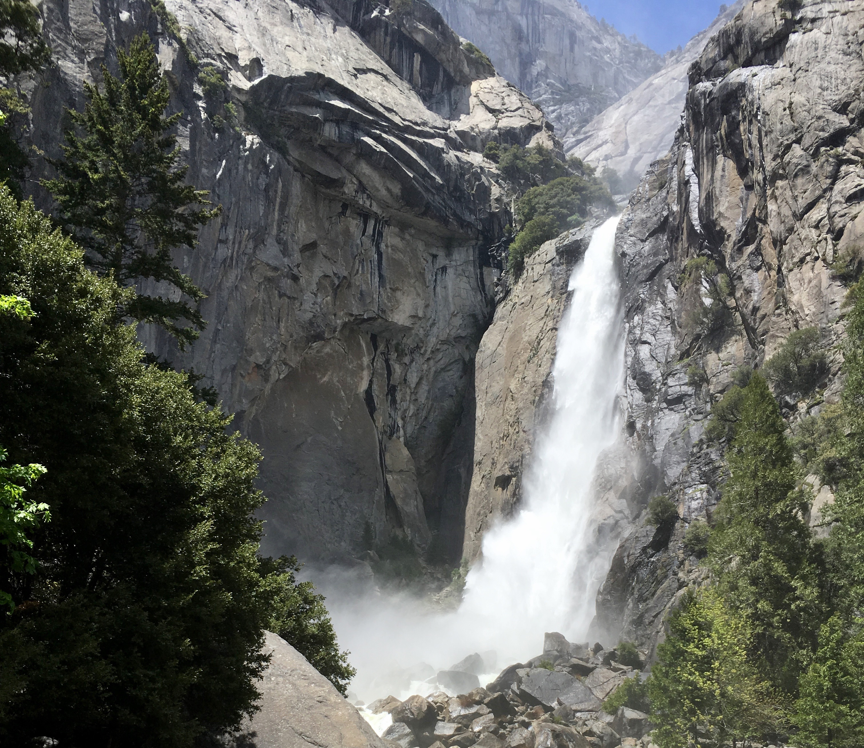
A short walk will lead you to the base of Bridalveil Fall, allowing you to get an up close view of this often-windswept waterfall. Plunging 620 feet (189 meters), Bridalveil Fall is the first major waterfall you'll see when entering Yosemite Valley. In spring, it thunders; you can expect to get wet! In some cases the spray is so strong, you may not even be able to easily access the end of the trail. During the rest of the year, look for its characteristic light, swaying flow.
The trail that leads to the base of Bridalveil Fall begins at the east end of the Bridalveil Fall Parking Area, which is laid out like a loop, with a single entrance on the west side of the lot. A wooden building with men's and women's restrooms is in the center of the parking lot loop, with trash and recycle bins in front. Tall pines and cedars surround the area and the fall is not visible from the parking lot.
Enjoy an up close view from the base of this often-windswept waterfall. Especially in the spring, expect to get wet while standing at the base of this thundering waterfall that plunges 620 feet (189 meters). In some cases the spray off Bridalveil Fall is so strong, you may not even be able to easily access the end of the trail. During the rest of the year, look for its characteristic light, swaying flow. Expect icy and very slick conditions in winter.
This paved viewing area is roughly circular in shape, bounded by natural boulders and rock wall barriers. At the center of the viewing area there are numerous low-lying boulders. Directly next to the viewing area, below the falls and outside the flow of the creek, there is thick vegetation. Above the viewing area, a waterfall flows directly onto large boulders. The walls surrounding the waterfall are stained dark, contrasting with the lighter greys and beiges of the granite further from the waterfall. Some of the wall near the waterfall even includes bright green mosses and vegetation growing in the cracks. The area around the waterfall exhibits a characteristic hanging glacier shape: there is a U-shape to the creek bed above the waterfall, ending in a very abrupt cliff over which the waterfall flows.
Picnic tables and grills are conveniently located at this scenic spot along the Merced River that offers views of El Capitan. This picnic area is available from dawn to dusk. Cathedral Beach Picnic Area, is located on Southside Drive, several miles east of Bridalveil Fall.
The Cathedral Beach Picnic Area is on a dirt road that is located on the left side of Southside Drive, the eastbound, one-way road leading into Yosemite Valley. The dirt road leads down a small hill into a heavily forested area, passing vault toilets and trash and recycle bins on the left, along the way. There is a dirt, circular, parking area, with no designated parking spots at the bottom of the hill. Picnic tables with accompanying grills are randomly spaced out along the perimeter of the dirt parking area. Multiple paths lead out of the forest and onto an open sandy and pebbled beach, along the Merced River. The massive El Capitan rises above the treeline.
The shimmering waters of Cathedral Lakes rest below Cathedral Peak, named by the California Geological Survey (CGS) in 1863. The trail climbs steadily to Upper Cathedral Lake. Near the top of the climb, it passes a spur trail to Lower Cathedral Lake (0.5 mile to lake). The return hike follows the same route. This is one of the busiest trails in the Tuolumne Meadows area.
The Cathedral Lakes Trailhead is located on the south side of Tioga Road in Tuolumne Meadows and is marked by a brown metal sign. The sign reads Cathedral Lakes, and has an icon of a backpacker and an arrow that points south. Limited roadside parking is available on both sides of the road. The northside of the road is an open meadow with panoramic views, while the south side of the road is forest. Along the roadside parking, near the beginning of the Cathedral Lakes Trail are four brown food lockers, three green recycle bins, three brown trash bins, then another six food lockers. A little further down the road are five portable restrooms, summer only. A yellow metal sign with a black outline and black text reads, warning, bear damage is common in this parking area. The sight or odor of food in your vehicle greatly increases the chance of your car being damaged! Federal regulations state that all food be removed from your vehicle and stored in the bear-proof boxes located in each campsite. Don't be bear careless! An illustration of a black bear is at the top of the sign. <br /><br />A wooden sign at the trailhead has text carved out of it that reads, Cathedral Lakes - 3.5 miles, Sunrise H.S.C. - 7.8 miles, and Yosemite Valley - 21 miles. The dirt path descends into the forest. A slender, four-sided, wooden post sticks out of the ground and reads, no camping, on all four sides.
Chilnualna Falls, pronounced "Chil-noo-al-na," flows all year, with peak flow in May. It is a strenuous hike, but well worth it for its views of the falls and Wawona Dome. Chilnualna Falls are comprised of five large cascades sliding through and over large granite formations above the Wawona basin - water here is fullest in spring and early summer. This strenuous trail allows for you to view the Chilnualna Falls cascades in many locations along the hike.
The parking area for this trailhead is located in a residential area. There is an information board that tells about the hike, the flora and fauna found in the area, a history of the trail, and a bit about the waterfall. There is a basic map that shows the trail, represented by a squiggle line, that runs along the river.
The Chinese Laundry houses interactive displays and exhibits that celebrate the Chinese workers who helped make Yosemite what it is today. The exhibits in this historic building highlight a previously forgotten story in Yosemite’s rich and diverse history.
A simple brown building with shingle siding and several windows on each side. The roof is peaked with a small window near the top. At the front, there is a small roof overhanging the building's entry porch. The entry has a small step leading up to the small porch from the side. The porch has wood paneled floor and a simple fenced railing that wraps around the corner opposite the steps. The door to enter the building is on the front of the building, on the left right after going up the step. The building is next to a narrow road and surrounded by small and medium-sized cedars and pines.
Let the views of Half Dome and Glacier Point across Ahwahnee Meadow inspire you as you enjoy a picnic at Church Bowl Picnic Area. There are picnic tables and grills at this scenic spot along Ahwahnee Meadow. Potable water and flush toilets are available.
Church Bowl Picnic Area is located right off the road, along Ahwahnee Drive. There are scattered picnic tables in the dirt, among tall incense cedars and ponderosa pines. Parking is available right off the road. A brown wooden structure in the midst of the picnic area is the restroom facility. Across the street, views open up in the Ahwahnee Meadow. Half Dome and Glacier Point are clearly visible from here.
Walk through the heart of it all! Enjoy views of Yosemite Falls, Half Dome, Sentinel Rock, and Royal Arches from the center of Yosemite Valley as you saunter through this large open meadow. This short, easy walk offers stunning views of Yosemite Falls, Half Dome, Glacier Point, and Sentinel Rock. From the visitor center, walk west along the bicycle path toward Lower Yosemite Fall. At shuttle stop #6, cross the street and follow the bike path, bearing left as the path forks.
Approaching Cook's Meadow can be a different experience throughout the seasons. In summer, the plants and grasses in the meadow are tall, erect, and green. In fall, the plants and grasses appear to be trampled, lay flat, and look dry, and yellow. In winter, the meadow may be snow-covered, and in spring, it may glisten and sparkle first thing in the morning due to frost. There is a raised boardwalk that circles the meadow with wayside exhibits along the way. From the middle of the meadow, trees no longer obscure the view, and a 360 degree panoramic view of the near 3,000 foot cliff walls open up. Facing north, the upper Yosemite Falls is showcased above the treeline. To the east, the iconic Half Dome is seen, also above the treeline. To the south, Glacier Point and Sentinel Rock rise above the treeline, and to the west, the length of the valley walls go into the distance and curve to the right, showing off the mighty works glaciers played in carving out such a broad valley.
Notice how flat the floor of Yosemite Valley is. At the end of the last glacial period, as with each post-glacial warming trend, huge volumes of water from melting glaciers flowed into Yosemite Valley, bringing tons of rock, gravel, sand, and silt. This debris slowly filled the shallow lake. A succession of bogs and marshes thrived before the meadows eventually appeared.
At a corner where the sidewalk splits into several different directions, a wooden post with the number two and an oak leaf and acorn symbol stands. A residential area can be seen up a street while across an adjoining street is an open meadow. Yosemite Falls can be seen through the trees.
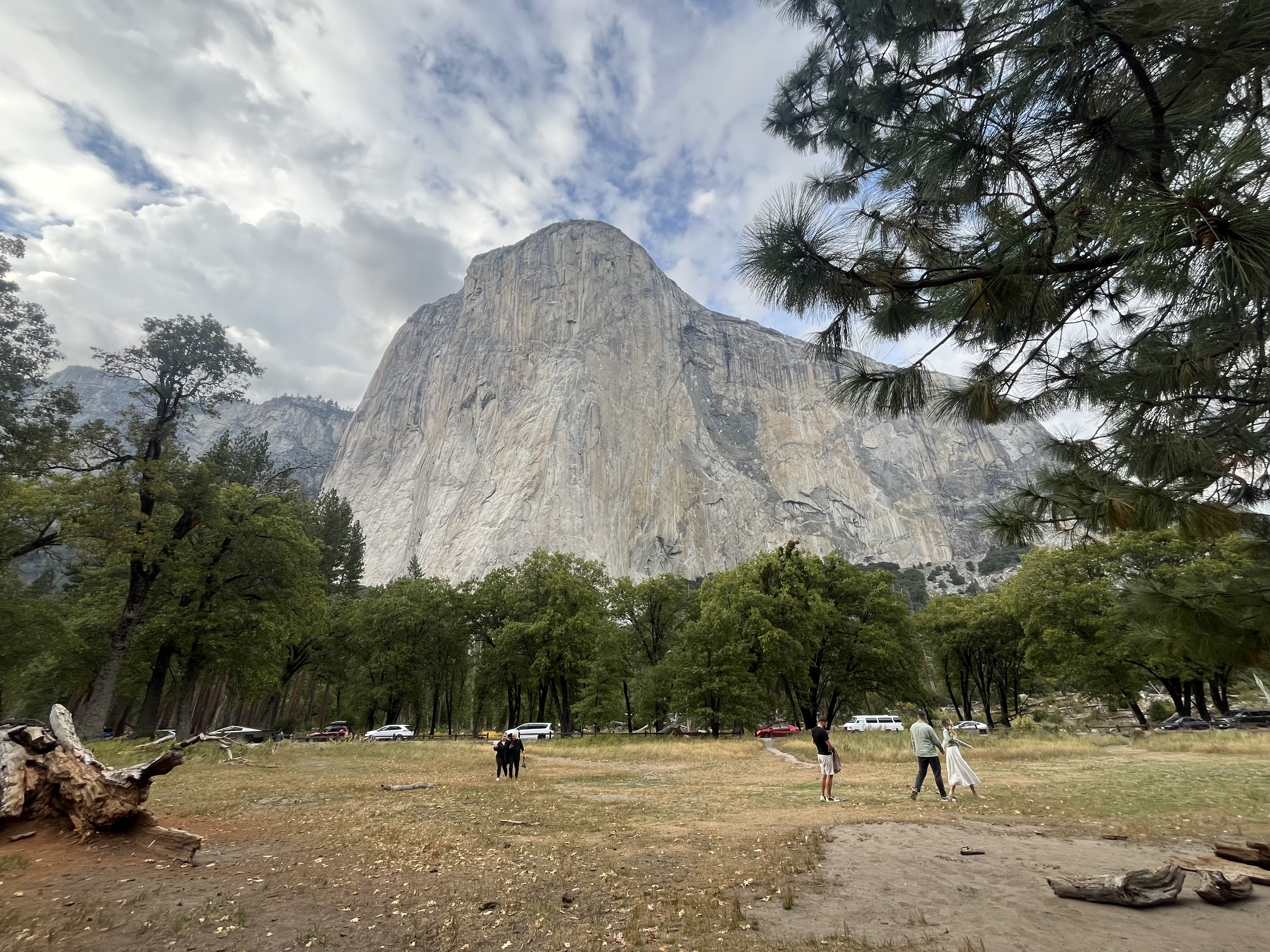
Look up to the granite walls, spires, and cliffs all around you! The rock's story begins about 100 million years ago with granitic magma deep within the earth. This molten material was formed from older continental rock, as it was over-ridden by the westward-moving North American Plate. About 35 million years ago, dramatic uplift began that eventually raised the Sierra Nevada to its current height.
An oak leaf and acorn symbol and the number one are carved into a slender wooden post located next to the sidewalk. The sidewalk is between the visitor center and the road. Yosemite Falls can be seen through the tall trees that grow in the areas that aren't paved.
The weather in Yosemite Valley differs from other places in the Sierra Nevada with similar elevations: summers are warmer and winters are colder. Here, the 3,000-foot-high cliffs trap warm air in the summer and funnel cold air down Merced and Tenaya canyons in the winter. The cliffs also shade half of the Valley because of the low-angled winter sun. The Sierra Nevada enjoys a "Mediterranean" climate, which means relatively dry summers and wet winters.
Along a paved path on the outskirts of a large, open meadow, views of the east end of Yosemite Valley open up. High cliff walls rise up on the left and right sides of the meadow, and Half Dome is visible through the trees. A wooden post with the number six and an oak leaf and acorn symbol stands in the meadow beside the path.
In 1855, only four years after the Ahwahneechee were forcefully removed from the Valley, the first tourist party came by horseback. Within three years, the first hotel was established, and within ten years, there were four more. Look toward Lower Yosemite Fall and notice the swath in the trees. Early hotel owners cleared this section of forest so guests could easily see Lower Yosemite Fall. Most of the meadows were fenced, plowed, grazed, and sown to grass for hay.
Along a paved sidewalk that is lined with a split wood railing and tall pine trees, a noticeable paved path has been forged through the trees to allow views of Yosemite Falls. In the opposite direction of the waterfall, across a street, is a large, open meadow, with high cliff walls that rise up across the meadow, and Half Dome peaking through the trees to the east. A wooden post with the number four and an oak leaf and acorn symbol stands in the meadow beside the path.
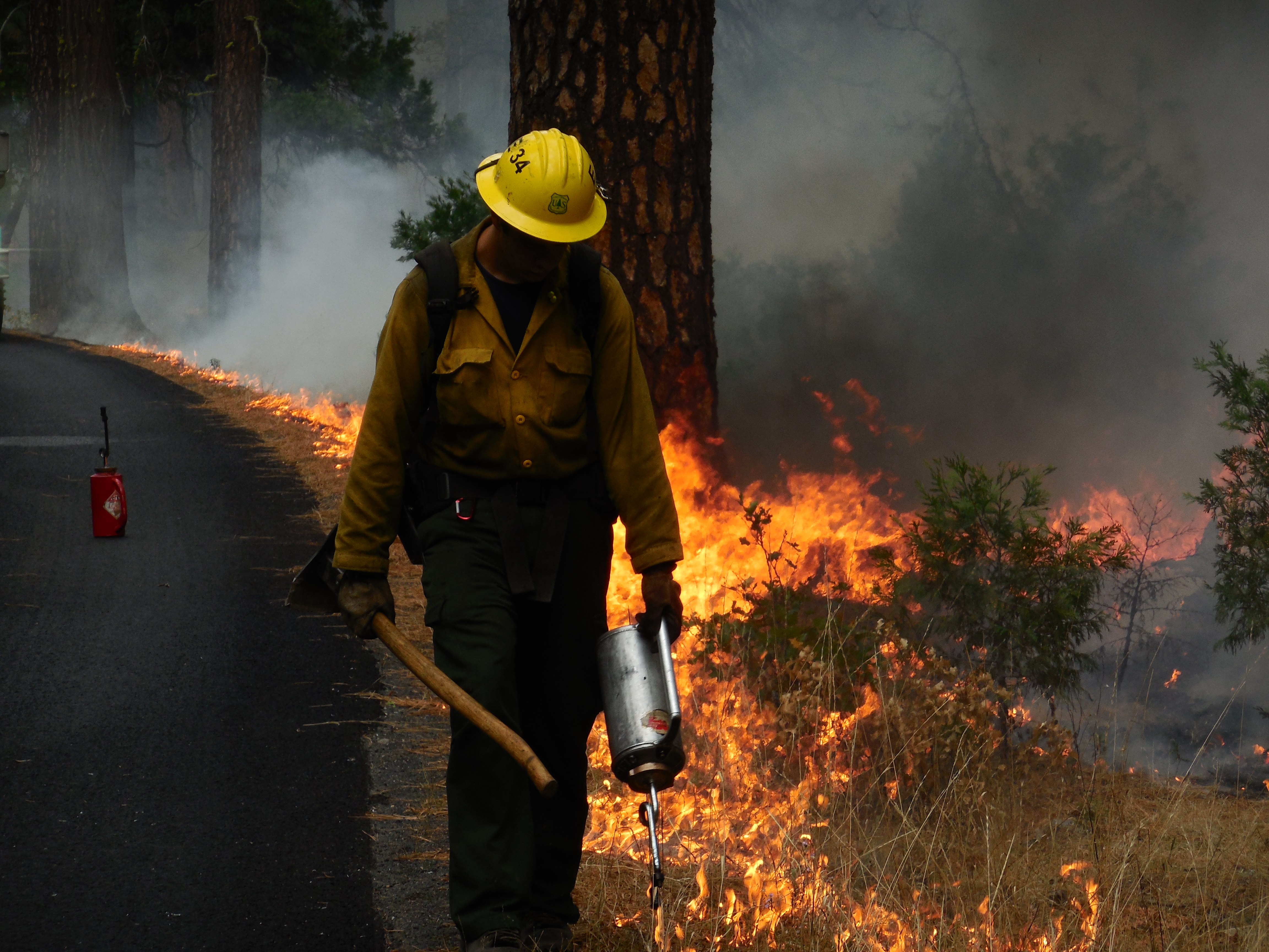
If we are to improve our ability to better care for our national parks, we must learn from the past. For example, early visitors to Yosemite misunderstood the essential role of fire, viewing it as merely destructive and dangerous and responding to it with alarm and fear. We now understand that suppressing natural lightning-caused fires can ultimately harm the plants and animals that have adapted to it.
Along a paved path on the outskirts of a large, open meadow, views of the east end of Yosemite Valley open up. High cliff walls rise up on the left and right sides of the meadow, and Half Dome is visible through the trees. A wooden post with the number five and an oak leaf and acorn symbol stands in the meadow beside the path.
It is believed that people were present in this valley as early as 8,000 years ago. Archeological evidence suggests that about 4,000 years ago American Indian people established permanent settlements here. The oak grove you are in now may have been a principal winter village area. Acorns from the black oaks were a main food source for the area's first people, known as the Ahwahneechee.
To the north of a paved path lined by a split rail fence is a wooden post that has the number three and an oak leaf and acorn symbol. Many oak trees line the path. Yosemite falls and the tall granite walk walls can be seen through the trees.
This is a good place to take a look at what John Muir called "the grandest of all the special temples of Nature I was ever permitted to enter. It must be the sanctum sanctorum of the Sierra (holiest of the holy places)." Changes that created this magnificent scenery occur over long periods of time. The cliffs and waterfalls will remain well into the future no matter what humans do. Changes caused by 150 years of tourism were rapid and damaging to the natural environment.
Along a paved path on the outskirts of a large, open meadow, views of the east end of Yosemite Valley open up. High cliff walls rise up on the left and right sides of the meadow, and Half Dome is visible through the trees. In the spring, the meadow is wet, most times flooded, allowing plush, vibrant green grasses and sedges, and colorful wildflowers to bloom. In late summer, the grasses have wilted and the meadow turns a yellow-ish brown. A wooden post with the number ten and an oak leaf and acorn symbol stands in the meadow beside the path.
If you are visiting during the busy summer months, you may notice noise and congestion. Since 1980, one of the management goals for Yosemite Valley has been to reduce traffic congestion and crowding. Plans for reducing the impact of automobiles, protecting the natural environment, and enhancing the visitor experience are being implemented.
Along a paved path on the outskirts of a large, open meadow, views of Yosemite Falls and the tall cliff walls on the east end of Yosemite Valley open up. A wooden post with the number eight and an oak leaf and acorn symbol stands in the meadow next to the path.
In the meadow to the left of the trail is an old river channel where yellow water lilies grow in the summer months. Every spring during high water, the Merced River reclaims this channel and water flows across this trail. Early hotel owners sought to drain areas like this to reduce mosquito ponds and dry the meadows enough to plow for hay production. The main Merced River channel is south of the trail. Its flow changes dramatically with the seasons.
Along a paved path on the outskirts of a large, open meadow, views of Yosemite Falls and the tall cliff walls on the east end of Yosemite Valley open up. A wooden post with the number seven and an oak leaf and acorn symbol stands in the meadow next to the path.
Throughout Yosemite National Park's history, countless efforts have been undertaken to preserve its ever-changing natural and cultural landscapes. Although it may not seem obvious today, Cook's Meadow was once one of the Valley's most developed areas. This spot also exemplifies how trees obscure many historic views. One hundred years ago, this cluster of trees was open meadow. Park plans call to restore historic scenic vistas and work is underway throughout the park to do so.
Tall trees rise up along a paved path on the outskirts of a large, open meadow. Little holes cover the trees, put there by woodpeckers hiding their stash of acorns for the winter. High cliff walls rise up on the left and right sides of the meadow, and Yosemite Falls is partially visible through the trees. A parking lot is nearby. A wooden post with the number nine and an oak leaf and acorn symbol stands in the meadow beside the path.
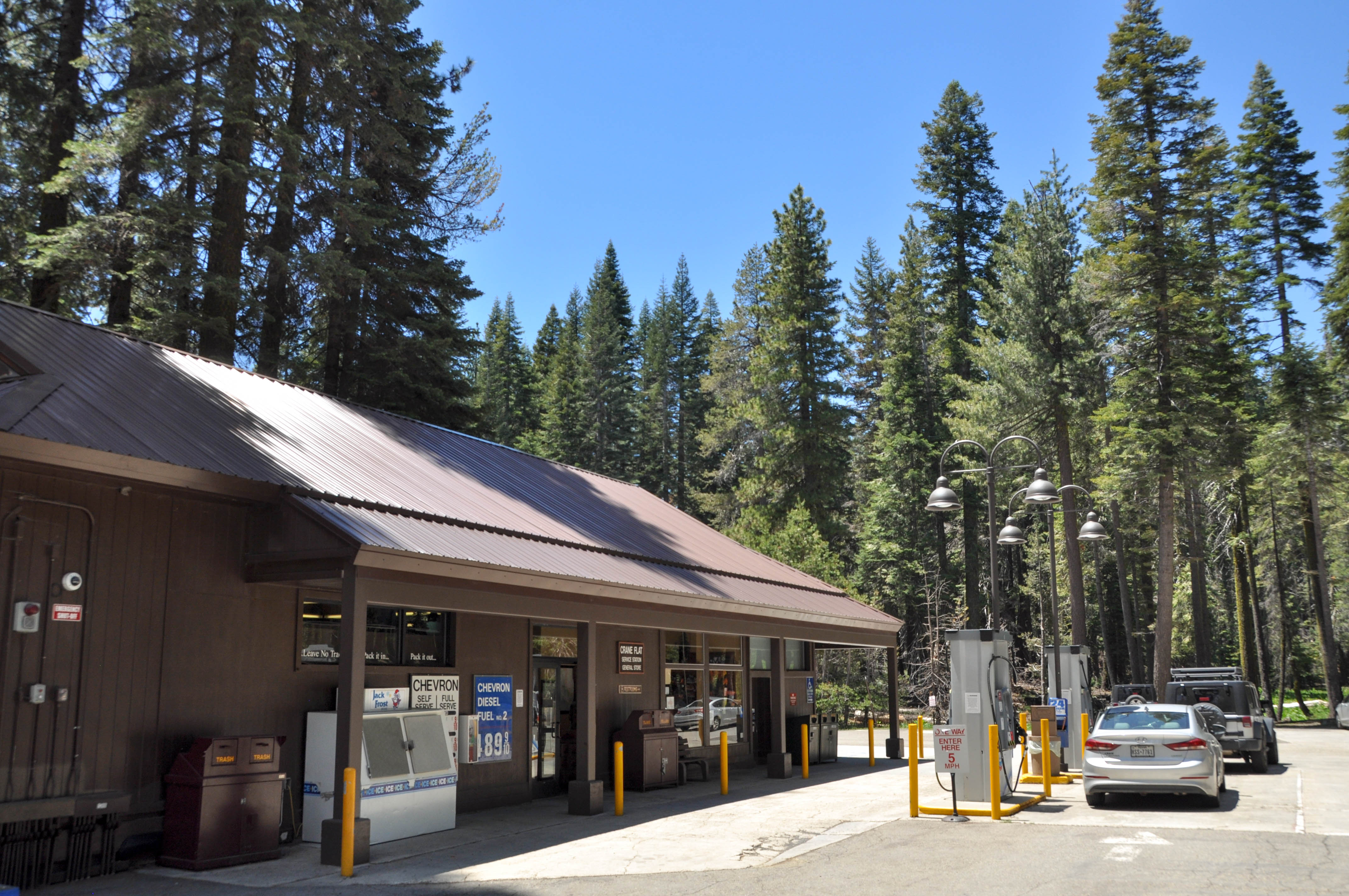
The Crane Flat Gas Station conveniently serves the northern end of the park for your refueling needs and is located at the intersection of the Big Oak Flat and Tioga Roads. The Crane Flat Store is open seasonally from spring through fall.
A long brown building with brown metal roofing and a covered porch that extends across three-quarters of the building serves as the Crane Flat Gas Station. In front of the store is a Jack Frost freezer that holds ice. It has a slanted front and stainless steel doors. To the right of the double glass entrance doors are two signs. The top one reads Crane Flat Service Station and General Store. The bottom sign reads restrooms with an arrow pointing to the right and has a wheelchair icon. To the left of the doors is a sign that shows the current gas prices. The gas station has two islands that each have two, two-sided gas pumps and two tall poles that split at the top and arc downward with two street lamps. A trash bin is in the center of each island. Tall trees surround the gas station parking lot.
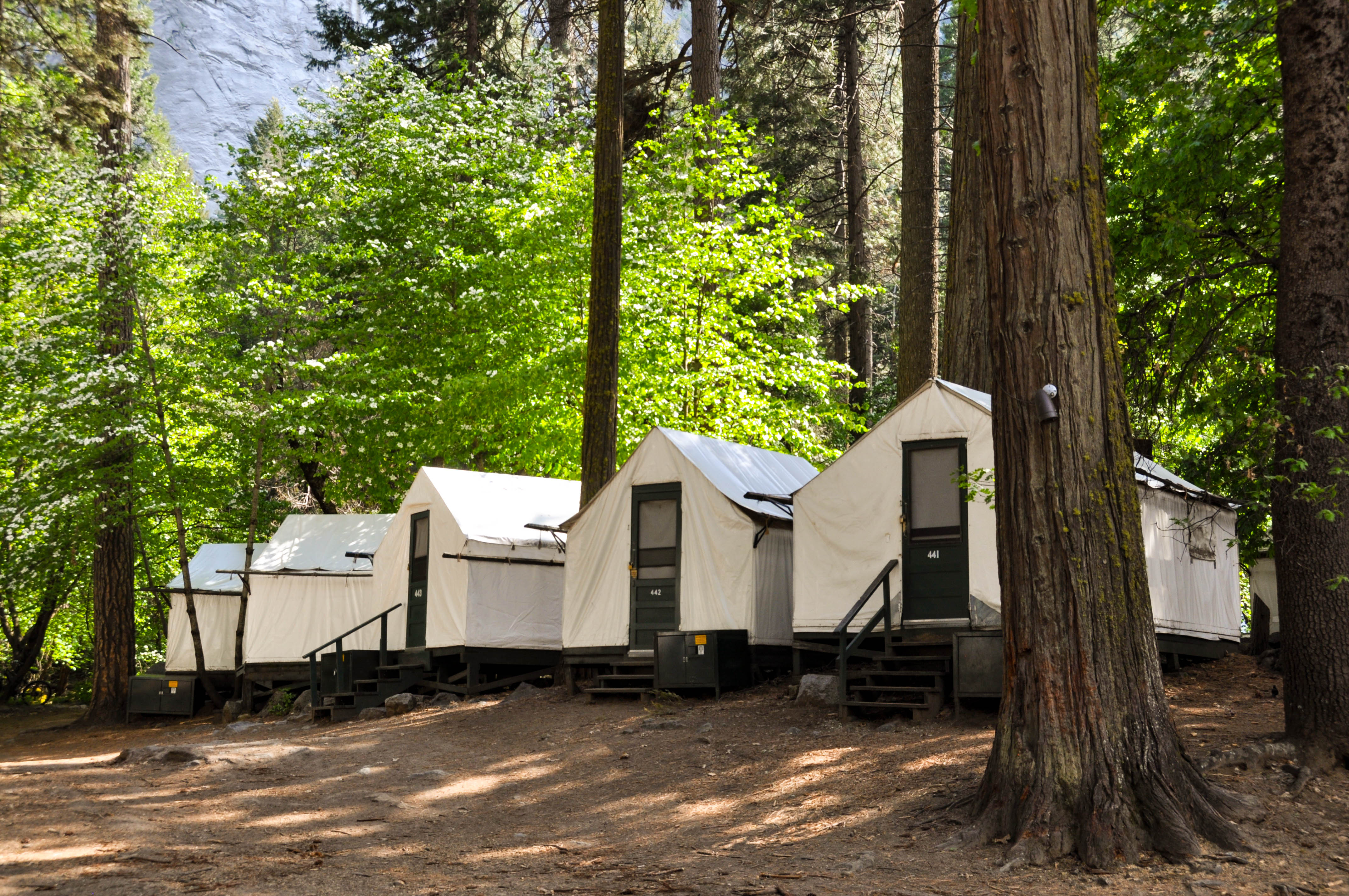
Beneath the grandeur of Glacier Point, Curry Village is known for the same warm, hospitable feeling that was instilled by its founders, David and Jennie Curry in 1899.
The Curry Village lodging property expands out in both directions from the front office building. The front office building is a small, wood, structure that you enter from the right side, check-in at the front desk which extends across the length of the building, then walk out the opposite side of the building. The front side of the building is made up of six panels, which each have 15 square window panes that go from near the floor to the ceiling. To the right of the front office is a wood building, with a covered porch and cobblestone porch barrier-wall that surrounds it. This building holds about 18 rooms, with entrances surrounding the single-floor building. Beyond the building to the north, are rows of hard-sided cabins. Behind and to the south of the front office building are about 400 white, canvas, tent-cabins.
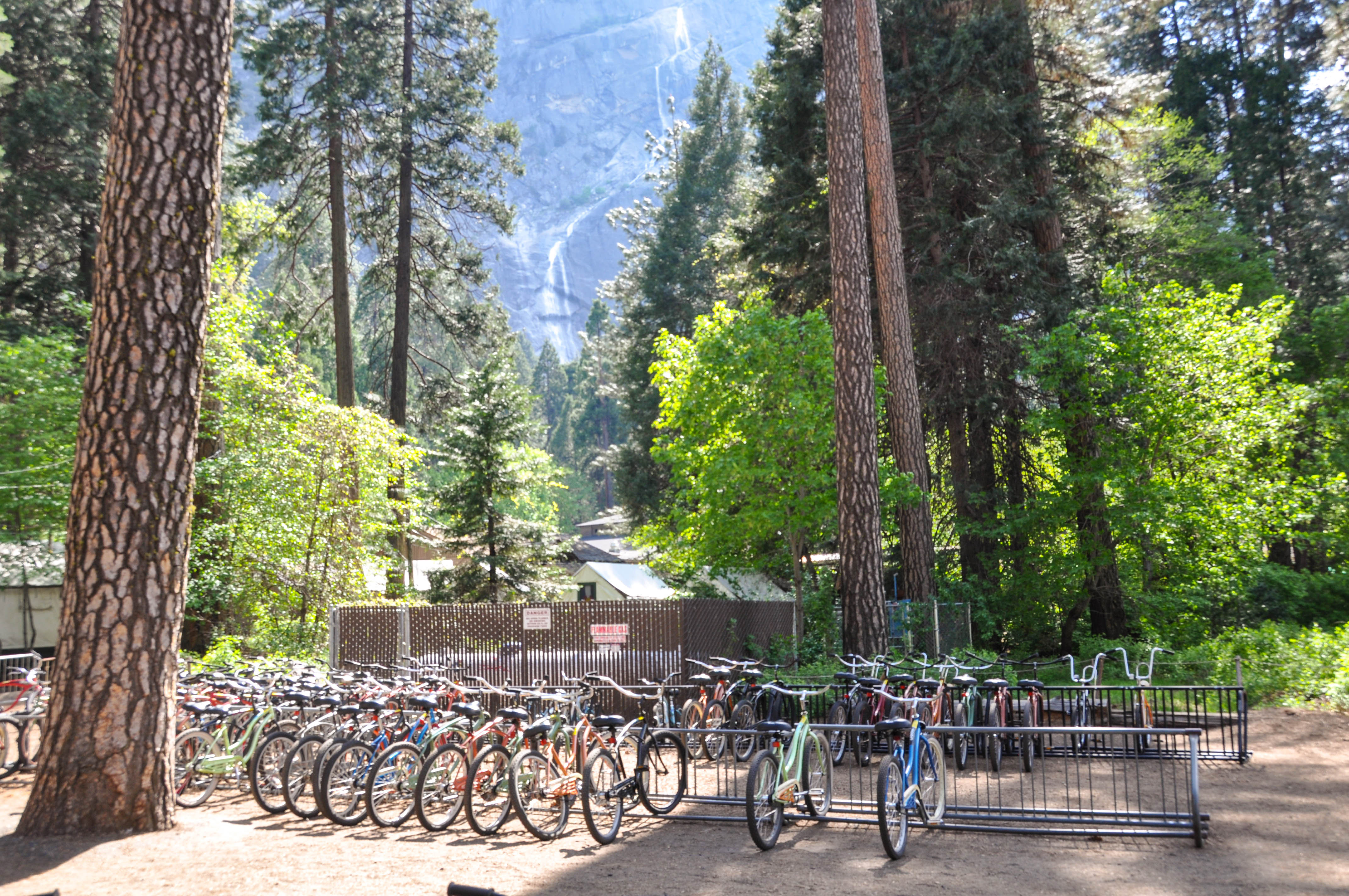
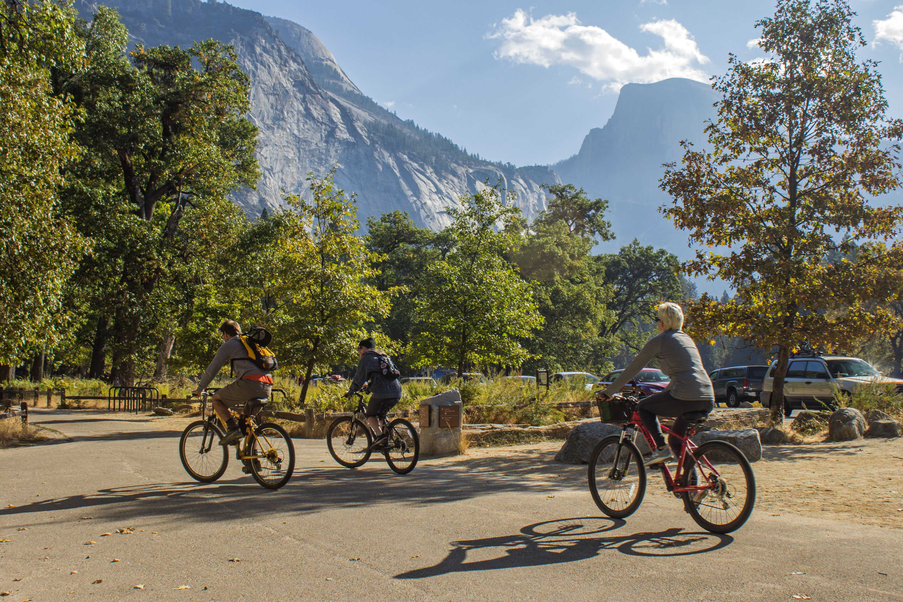
Biking is one of the best ways to see Yosemite Valley. Yosemite Valley is flat, which makes for easy riding along our 12 miles of designated paths. Bicycles, tag-along bikes for children, trailers, and helmets are available for all ages and abilities. We also offer a select number of tandem bikes and hand-crank bikes for guests with physical limitations. Wheelchairs, electric scooters, and strollers may also be available for rent.
The Curry Village Bike Stand operates out of a small, brown, wood-paneled kiosk. It is located next to the Curry Village parking lot. Rows of bikes are parked side by side inside a railed fenced area. The bikes are a variety of colors and range in size from larger adult-sized bikes, to smaller child-sized bikes, to tandem bikes, and bikes with trailers for children. Granite walls rise high to the right of the building and tall trees line the outskirts of the bike stand area.
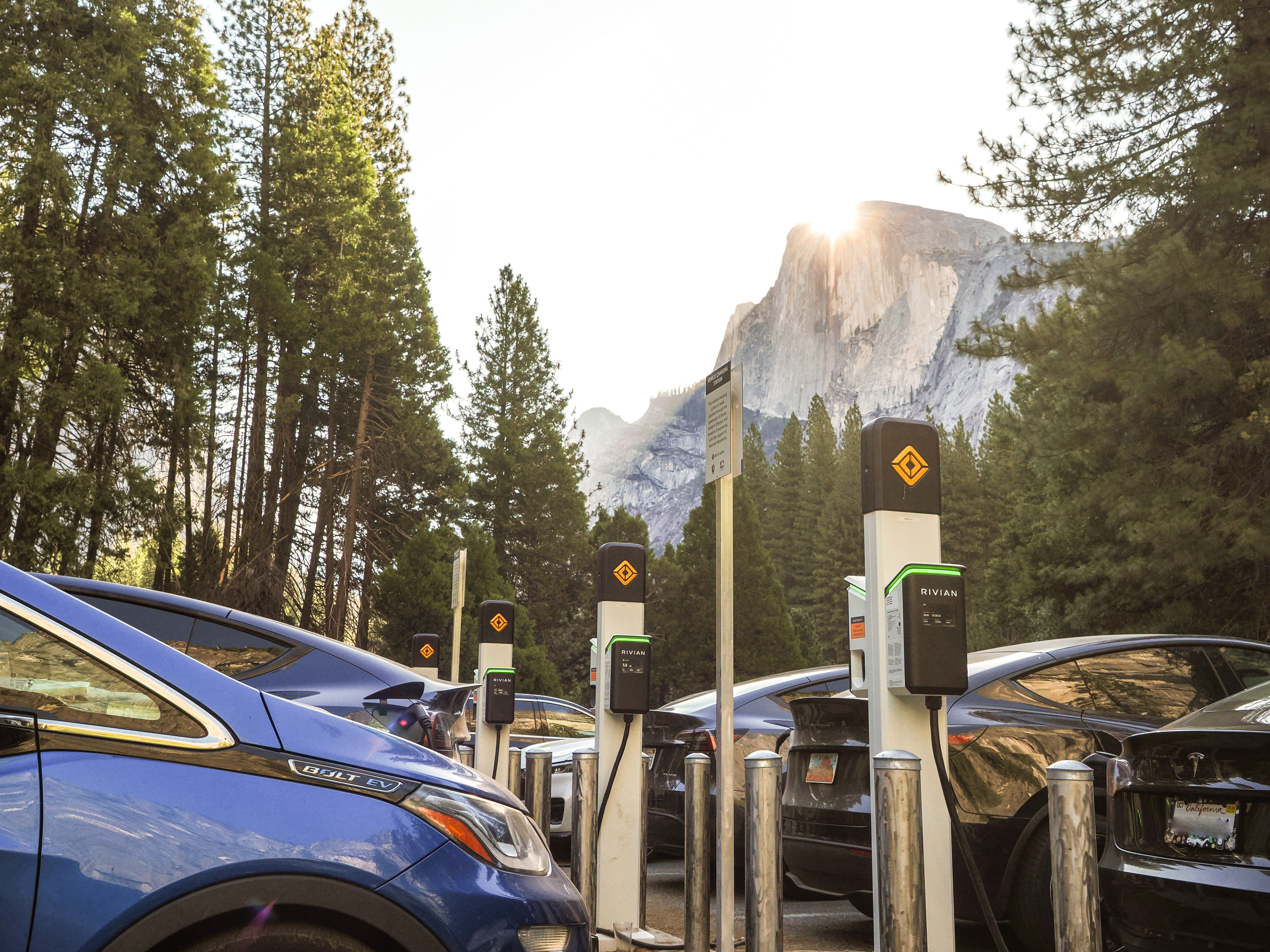
Located in the parking lot west of Curry Village and just east of Stoneman Bridge, this electric vehicle (EV) charging station features 20 level 2 chargers. Chargers have a J1772 connector.
In the center of a moderately sized parking lot, there is a row of 10 electric vehicle charging stations on a concrete footer about three feet wide. Each station is a narrow post about five feet tall with two boxes on the sides for two separate charging ports. The stations are located in between two parallel rows of parking stalls so that the short edge of each parking stall borders a station. Each port has a long black cord with one end plugged into the station as a power source and the other end with a connector, which can be hung on the side of the port when not in use. The front of each port has a screen with charging information and above the screen is the word "Rivian". Surrounding each charging station are four cylindrical metal posts about three feet tall to protect the station from damage. Next to both stations there is a metal sign on a post that reads: "Vehicle Charging Station. This vehicle charging station is made possible through the generosity of Rivian, Adopt A Charger, and Yosemite Conservancy with the support of Yosemite Hospitality." Behind the charging stations is a sidewalk that runs perpendicular to the parking stalls.
In the mid-1800s, European-American settlers planted apple trees around Yosemite Valley to provide fresh produce and cider to the growing number of people drawn to the area. Now, this area serves as a parking lot for visitors who wish to use the Curry Village lodging, dining, and gift shop services, or to use the free shuttle bus. Open year-round for Curry Village overnight guests.
A long, paved, parking area holds four rows of parking. There are designated accessible parking spots at both ends of the paved lot. Rows of white, canvas, tent-cabins line the west side of the lot. The area is surrounded by a full stand of trees. At the far end of the paved parking area, opposite the entrance, the road turns left and enters a larger dirt parking area, offering about 10 rows of parking. Once an old apple orchard, apple trees still stand throughout this dirt lot. Half Dome can be seen above the tree line.<br />
The front office building is a small, wood, structure that you enter from the right side, check-in at the front desk which extends across the length of the building, then walk out the opposite side of the building. The front side of the building is made up of six panels, which each have 15 square window panes that go from near the floor to the ceiling. The lounge building is a single-story structure with a large covered porch. The building is covered in wood shingles and paneling. There are unpeeled log accents around the doors and windows as well as unpeeled log pillars around the porch. The covered porch has a wood plank floor with two steps leading up to it. There are paned windows all around the building and a set of glass paned double doors at the entrance.
To the right (west) of the front office is a wood building, with a covered porch and cobblestone porch barrier-wall that surrounds it. This building holds about 18 rooms, with entrances surrounding the single-floor building. There is one step leading up to the covered porch, which is made of a concrete floor. There are painted wood pillars sparsely placed around the front edge of the porch.
John Degnan settled in Yosemite Valley in 1884, and began working as a laborer and caretaker for state administrators there. His wife, Bridget, added to the family income by selling bread she baked daily in Dutch ovens. As travel to Yosemite increased, the demand for her bread grew. A larger oven, capable of producing 50 loaves per day, was used until 1900, when the Degnans ordered a large brick oven for a more permanent bakery. This bakery was originally connected to the Deg
This building is simple in structure and is made of wooden planks. To the left is a door with a small triangular roof overhang, and to the right, is a small rectangular window. Two picnic tables and two wooden stump stools are in the front.
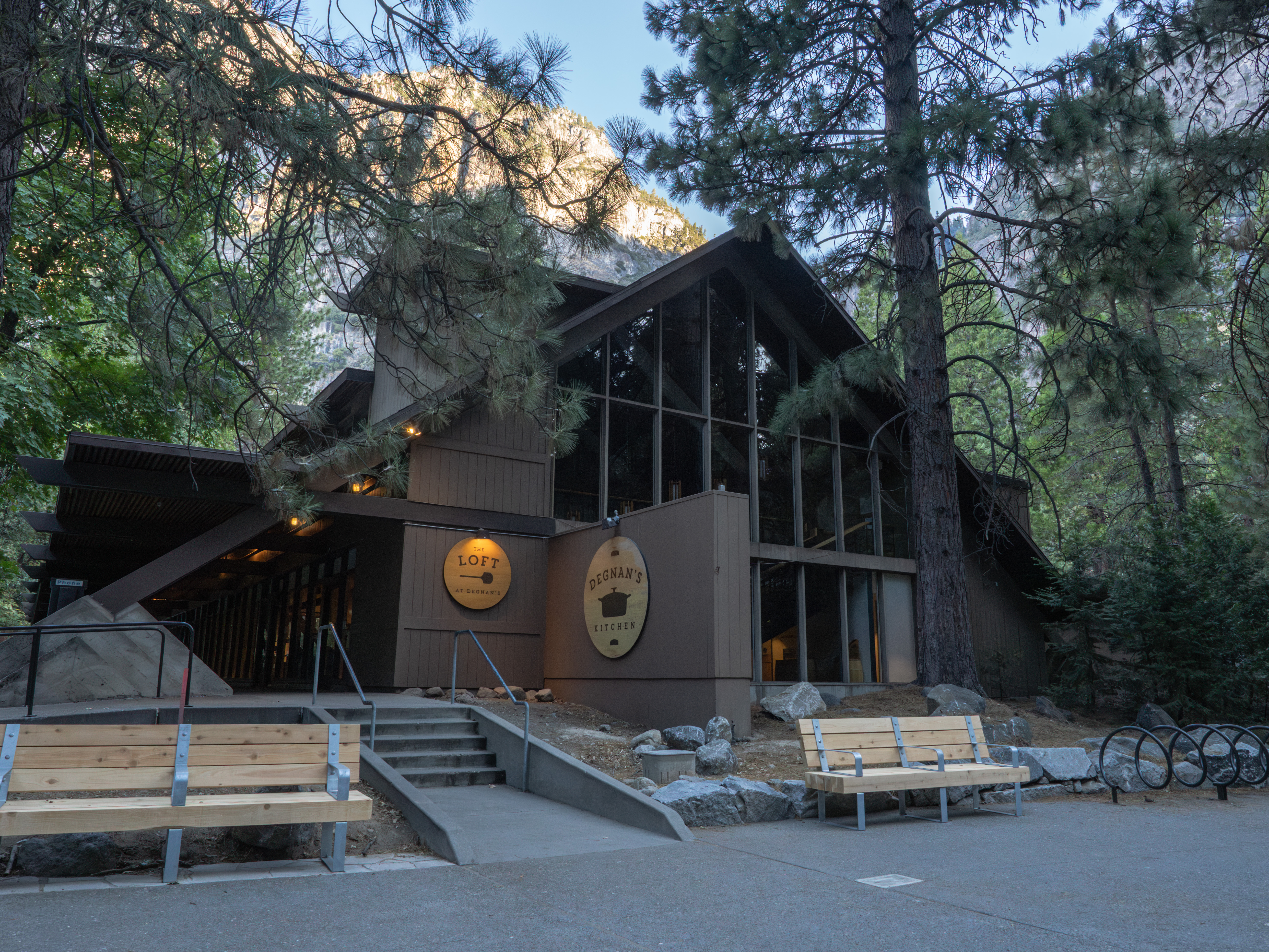
Deli sandwiches, signature salads, artisan pizzas, breakfast favorites, coffee / espresso drinks, fresh donuts, baked goods and a wide selection of soft drinks and other beverages are available at Degnan's Kitchen. Numerous seating areas are available to relax and enjoy a quick meal. Open year-round, see website for hours. Located in eastern Yosemite Valley, in Yosemite Village.
Degnan's Kitchen is located on the first level of a brown, two-story, A-frame building. The beams of the A-frame building extend to the ground, creating a covered walkway along the west side of the building. A circulular wooden sign reads Degnan's kitchen and has a picture of a black dutch oven pot. Several circular picnic tables and trash and recycle bins are located on the north and west sides of the building.
El Capitan Meadow offers a view of both the eastern and western faces of this iconic granite formation, rising over 3,000 feet above the meadow. El Capitan Meadow also provides great views of Lower and Middle Cathedral Rocks as well as the Cathedral Spires. During the full moon, moonlight illuminates El Capitan with an otherworldly glow that can be viewed from this meadow.
The El Capitan Meadow is located along Northside Drive, the westbound, one-way road that leads out of Yosemite Valley. The meadow, including open views of the Cathedral Rocks across the valley, are on the left side of the road, along with roadside parallel parking. To the right side of the road is a forest that extends to the base of El Capitan. The meadow can be a different experience throughout the day and with every season. In summer, the plants and grasses stand tall and erect and are a vibrant green. In fall, the meadow appears to be trampled, and the tall grasses may lay flat, and look dry, and yellow. In winter, the meadow may be snow-covered, and in spring, it may glisten and sparkle first thing in the morning from frost. Throughout the day and even into the night, people find a spot to enjoy unobscured views of climbers, spotted on the vertical rock wall. At night, climbers turn on their headlamps to settle into their portaledge, or hanging cots, for the night, creating polka dots of light scattered across the rock wall. During a full moon, the rock walls are lit up by the bright light of the moon.
Delight in the thrill of spotting climbers on El Capitan while you sit back and enjoy your picnic beneath this gigantic granite monolith.Picnic tables and grills are conveniently located at this scenic spot beneath the massive cliff face that is El Capitan. Hours :This picnic area is available from dawn to dusk. Getting Here :Located on Northside Drive, near El Capitan, a few miles west of Yosemite Valley Lodge, at El Capitan shuttle stop E3. Rules & Regulations :Picnic are
The El Capitan Picnic Area is located on a side road that makes a half circle through a forested area, just off Northside Drive, near El Capitan. There is a designated entrance to the road that then travels clockwise to the parking area, and then to the designated exit. To the right of the road, and beyond the parking spots lies the Picnic tables and accompanying grills, randomly scattered through this forested area. A shuttle stop is also located on the right side of the road. To the left of the road, there is a vault toilet, trash and recycle receptacles, and food lockers. El Capitan and other nearby rocks tower over the treeline. Climbers are sometime seen on these portions of exposed rock walls.
Located in the parking lot adjacent to the El Portal Market and Gas Station, this electric vehicle (EV) charging station features two level 2 chargers. Chargers have a J1772 connector with a power output of 11 kW.
At the northernmost edge of the parking area for the El Portal Market and Gas Station, about 100 feet opposite the main highway, there is a small gravel parking area in front of one electric vehicle charging station. The station is a narrow post about five feet tall with two boxes on the sides for two separate charging ports. Each port has a long black cord with one end plugged into the station as a power source and the other end with a connector, which can be hung on the side of the port when not in use. The front of each port has a screen with charging information and above the screen is the word "Rivian". Next to each charging station are two cylindrical metal posts about three feet tall to protect the station from damage. Next to both stations there is a metal sign on a post that reads: "Vehicle Charging Station. This vehicle charging station is made possible through the generosity of Rivian, Adopt A Charger, and Yosemite Conservancy with the support of Yosemite Hospitality." Behind the charging stations is a small grassy, unpaved area with a covered storage structure beyond that.
The El Portal Gas Station conveniently serves the western end of the park for your refueling needs. <br /><br />Diesel and propane available. <br /><br /> <b>Hours</b> :<br />8am to 5pm<br />Pay at the pump 24 hours with credit or debit card.<br /><br /> <b>Getting Here</b> :<br />The El Portal Gas Station is located on Highway 140, next to the El Portal Market.<br /><br /> <b>Accessibility</b> :<br />Attendants can assist with fuel service during business hours.
The El Portal Gas Station is a white building with a green roof and green trim around the windows. About two-thirds of the front of the building is made up of glass panels that reach from near the ground to the roof. A single green door with a large window serves as the entrance to the service desk area. The remaining one third of the front of the building is taken by a green garage door, made up of twelve large window panels. An overhead metal canopy covers an island containing two gas pumps. One pole-mounted squeegee bucket is attached to the two poles holding up the canopy, between the two pumps. a trash bin is next to one of the poles as well. One diesel gas pump sits outside the canopy. Near the road, a black and white metal sign reads no gas in Yosemite Valley. A red and blue sign reads Chevron and lists the current gas prices.
The Big Oak Flat Information Station has an information desk, wilderness permit desk, and Yosemite Conservancy Bookstore. In the winter, self-registration wilderness permits for the Crane Flat area and Tioga Road trailheads only, are available on the front porch. You must bring your own bear canister when the information station is closed. Wilderness permits are required for overnight stays in Yosemite's Wilderness. Designated accessible parking spaces are available in front of the facility.
The Tuolumne Meadows Visitor Center has an information desk, Yosemite Conservancy Bookstore, and an exhibit area detailing the area's geology, plant and animal life, and history. A designated accessible parking space and entrance are available. From the main parking lot, drive up the service road to the visitor center. Park in the designated accessible parking space, and follow the paved path in front of the visitor center to the rear entrance. Accessible restrooms are adjacent to the main parking lot.
The Wawona Visitor Center has an information desk, wilderness permit desk, and Yosemite Conservancy Bookstore. In the winter, self-registration wilderness permits for the Crane Flat area and Tioga Road trailheads only, are available on the front porch. You must bring your own bear canister when the information station is closed. Wilderness permits are required for overnight stays in Yosemite's Wilderness.
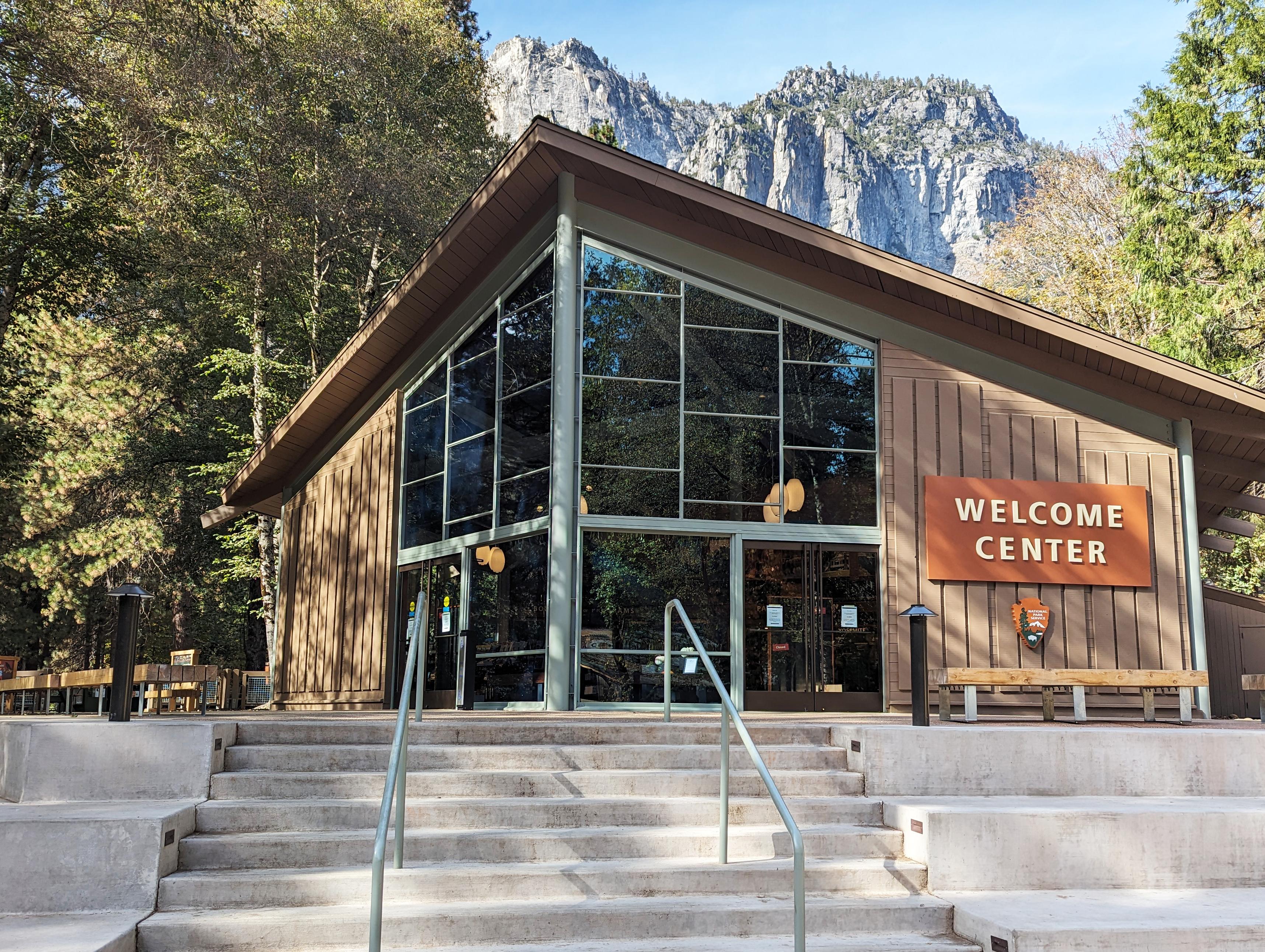
The Yosemite Valley Welcome Center is the NEW destination for visitor information in the Valley. Stop here before you begin your Yosemite adventure! The welcome center is located next to the Yosemite Village Parking and the Village Store in Yosemite Valley (Shuttle Stops 1 & 2.) Get help planning your visit and pick up free trail maps, junior ranger booklets, and more.
Cycling is a great way to experience the park and allows you to cover more ground during your time here. You can rent a bike, bring your own, or borrow one through the bike share program (2-hour limit). Hand-crank and tandem bicycles are also available for rent. Over 12 miles of paved bike paths are available in Yosemite Valley (speed limit is 15 mph). In addition, bicyclists can ride on regular roads (if they obey traffic laws).
Hiking in Yosemite
From a short walk to the base of a waterfall to a multi-day hike deep into the Yosemite Wilderness, taking a hike is one of the best ways to experience Yosemite's spectacular scenery. Yosemite has an extensive network of over 800 miles of hiking trails.
Scenic Driving in Yosemite
All of the roads in Yosemite National Park are scenic, but the most famous scenic drive is along the Tioga Road, a 46-mile (62 km) drive from Crane Flat to Tioga Pass. The road is typically open from late May or early June through sometime in November.
Watch the "Spirit of Yosemite" Film
The park film, The Spirit of Yosemite, is shown daily on the hour and the half hour in the theater behind the Yosemite Exploration Center. The first showing is at 9:30am, and the last showing is at 4pm.
Learn Art in the Park
Yosemite has a long history of inspiring visitors to create art. From world-renowned artists like Ansel Adams and Chiura Obata to everyday people who love art for fun, pausing to create something beautiful is a special way to experience Yosemite's towering cliffs, dramatic waterfalls, enormous trees, and granite high country.
Wildlife Safety in Yosemite
Yosemite National Park supports more than 400 species of vertebrates including fish, amphibians, reptiles, birds, and mammals. The high diversity of species is the result of diverse habitats in Yosemite that are largely intact. The park’s rich habitats range from thick foothill chaparral to conifer forests to expanses of alpine rock. Animals feel at home in each location.
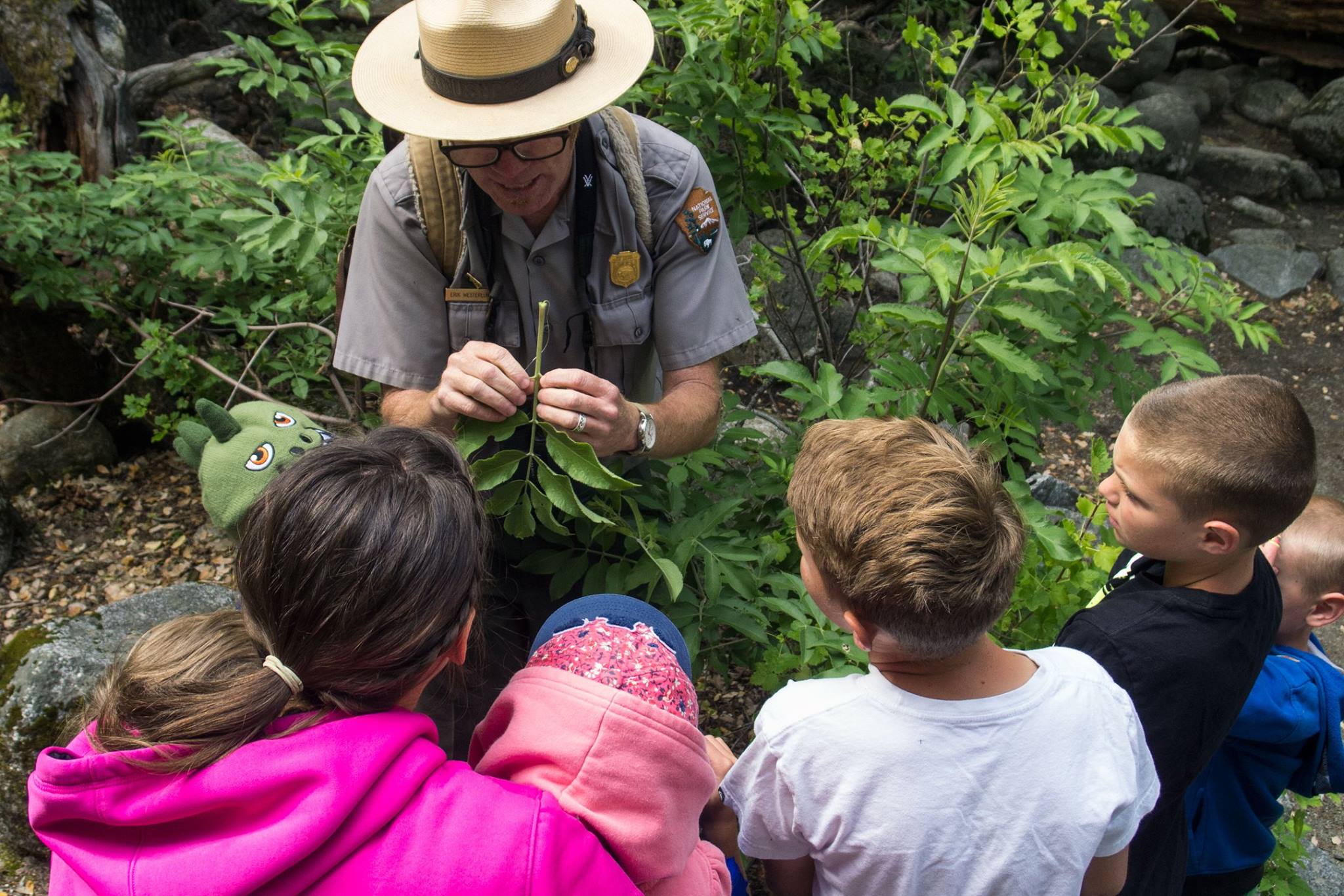
Become a Yosemite Junior Ranger
Kids can become a Yosemite Junior Ranger by taking a self-guided handbook with them as they travel around the park and complete the activities that are the best fit for them. The Yosemite Junior Ranger handbook is available for free at visitor centers. When you are done, share your booklet with a park ranger at any Yosemite visitor center during operating hours to receive your badge.
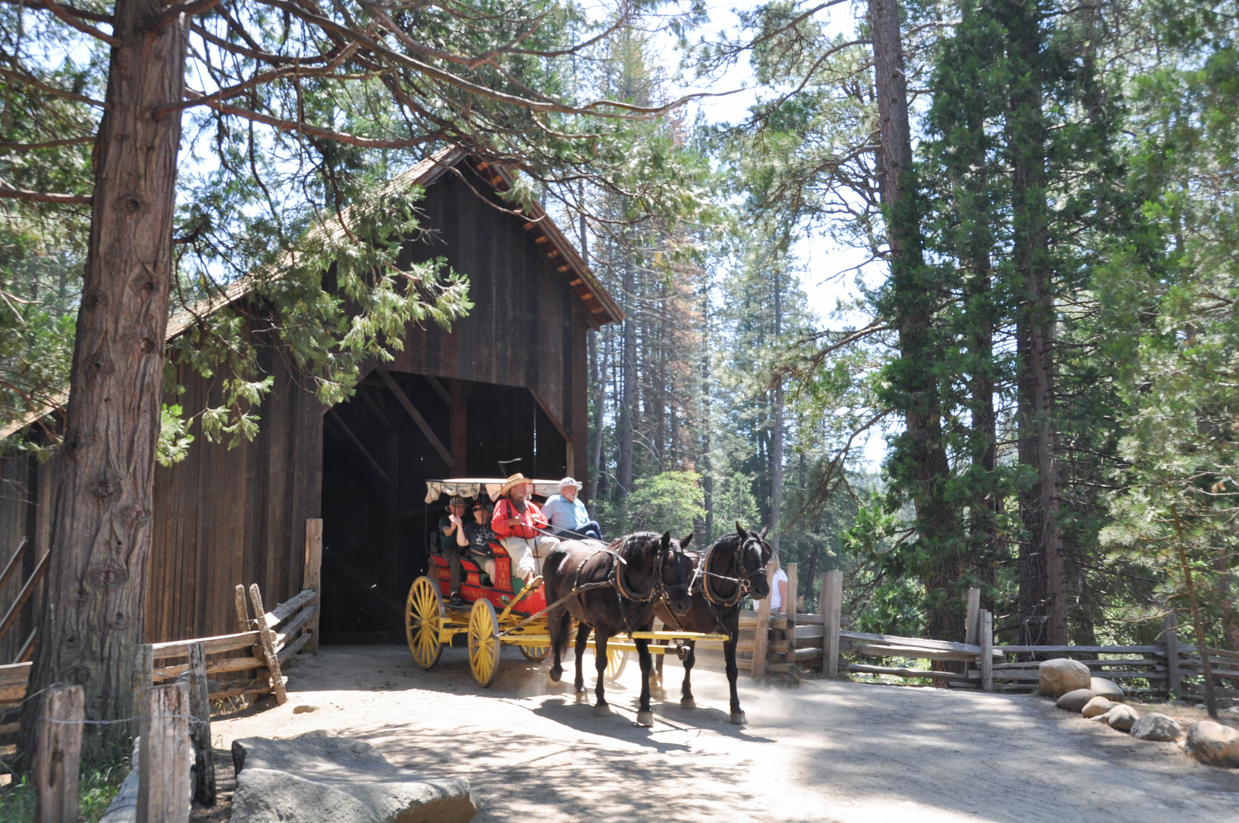
Visit the Yosemite History Center
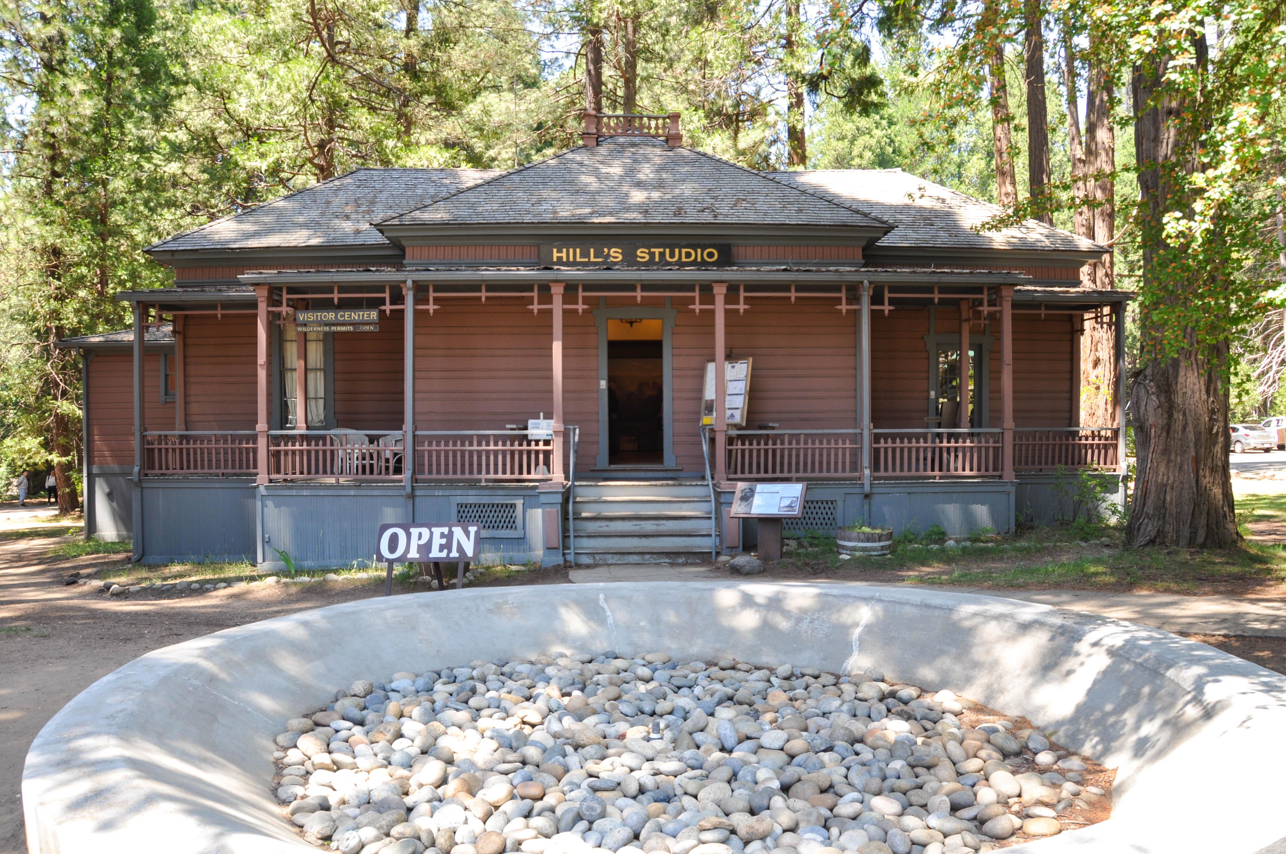
Go back to a time of horse-drawn wagons, a covered bridge, and rustic cabins. The Yosemite History Center is a collection of historic buildings where outdoor interpretive signs tell the stories of people who moved here from around the world and shaped the park’s development. During the summer, visit exhibits inside the Chinese Laundry and the Acting Superintendent's Office, take a ride on our horse-drawn wagon, or watch blacksmiths forge iron tools on a coal forge!
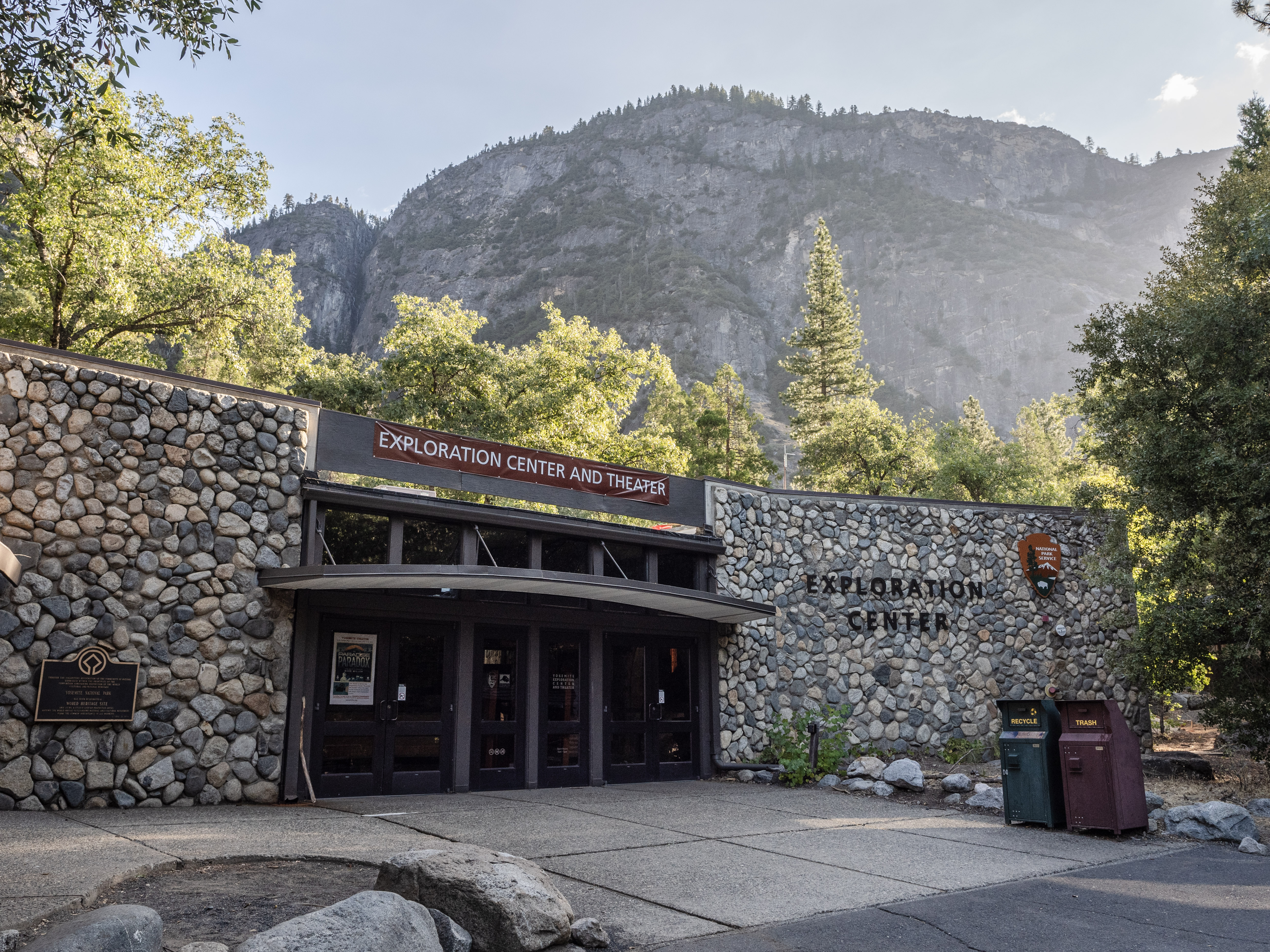
Visit the Yosemite Exploration Center
The Yosemite Exploration Center features interactive displays and exhibits highlighting Yosemite's many stories and resources. Bring the family and learn more about Yosemite's history, the people who originally called this place home, as well as more about meadows, animals, and sequoias!
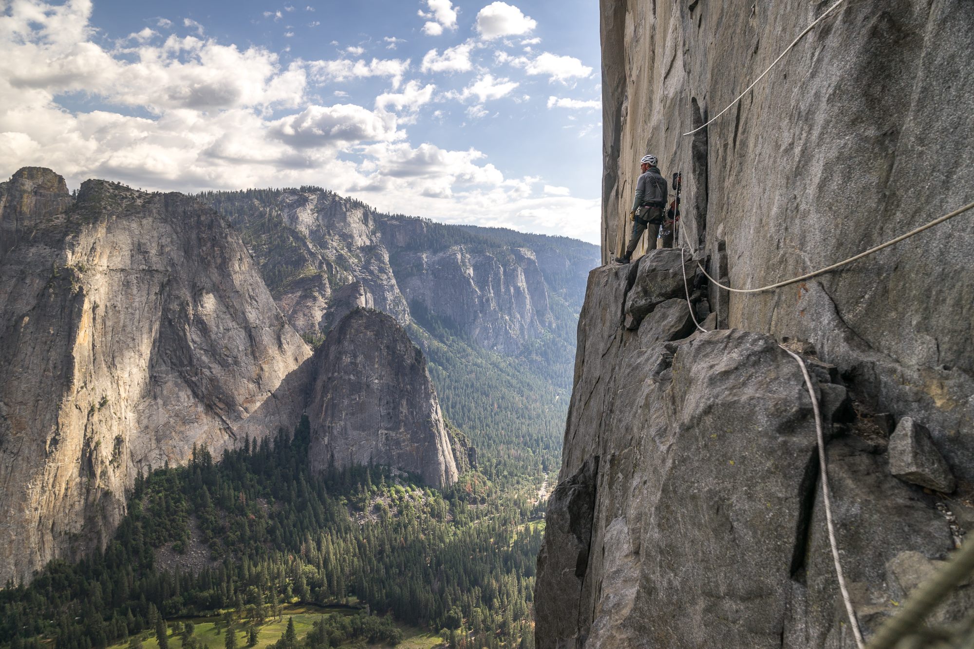
Rock Climbing in Yosemite
Yosemite is one of the world's greatest climbing areas. Climbers here can enjoy an endless variety of challenges--from the sustained crack climbs of the Merced River Canyon to pinching crystals on sun-drenched Tuolumne Meadows domes to multi-day aid climbs on the big walls of the Valley. Yosemite is not just a climber's playground, however: its walls and crags are an integral part of a larger ecosystem, protected as Wilderness.
Go Skiing at Badger Pass
The Badger Pass Ski Area is open from mid-December through March (weather and conditions permitting). You can downhill ski, cross-country ski, go tubing, or snowshoeing all from this historic winter resort.
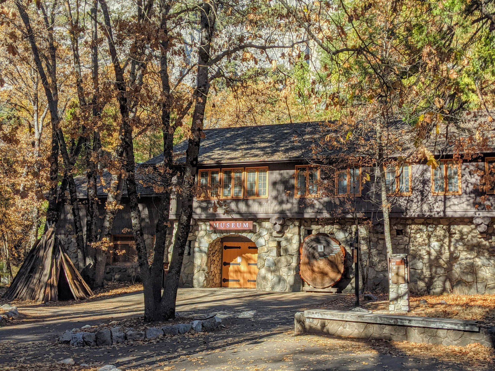
Visit the Yosemite Museum
Open year-round, the Yosemite Museum has displays that interpret the cultural history of Yosemite's native Miwok and Paiute people from 1850 to the present, demonstrations of stone tool making, basket-weaving, beadwork, and traditional games. In front of the museum is a cross-section of a giant sequoia tree that visitors can touch and a re-creation of an umacha, a Miwok and Paiute cedar bark house. The gallery inside the museum is open periodically with rotating exhibits.
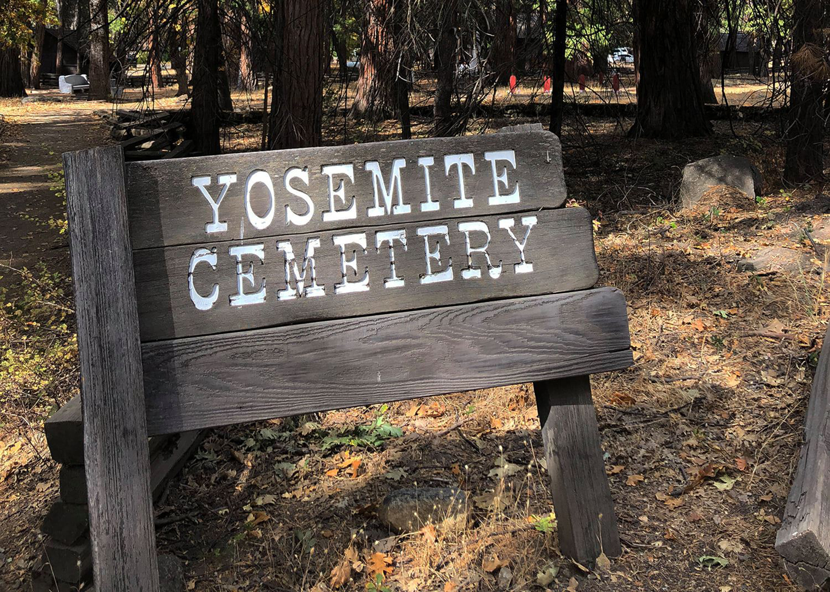
Visit the Yosemite Cemetery
The Yosemite Cemetery is full of stories, told and untold. Some of those laid to rest here are well-known figures in the history of the park. Some spent their entire lives in Yosemite and are now almost forgotten. Others were visitors about whom very little was known, even at their time of their deaths.
Tours
Count: 10
Mariposa Grove - Big Trees Loop Self-Guided Tour (Accessible)
Winding through an impressive forest with many giant sequoias, this trail offers numerous interpretive panels on the life and ecology of this unique place. This loop is relatively flat and is wheelchair accessible.
Mariposa Grove - Grizzly Giant Self-Guided Tour (Accessible)
Winding through a forest with many giant sequoias, this trail features the Grizzly Giant (the largest sequoia tree in the park), the California Tunnel Tree, and offers interpretive panels on the life and ecology of this unique place. This trail is relatively flat and is wheelchair accessible
Tioga Road - Wayside Exhibits (Accessible)
Wayside exhibits highlighting Yosemite's geology, ecosystems, natural and cultural history, etc., found along Tioga Road, from near Crane Flat to Tioga Pass, are grouped together in this tour. Each wayside exhibit is audio described. A few wayside exhibits are not on accessible paths.
Tuolumne Meadows - Soda Springs and Parsons Lodge Self-Guided Tour
Explore the mystery that is Soda Springs and delve into the history of Parsons Lodge on this delightful walk through Tuolumne Meadows. Soda Springs--cold, carbonated water bubbling out of the ground--is protected within a log enclosure. Historic Parsons Memorial Lodge offers exhibits (limited hours--see Yosemite Guide for schedule). A path to the bridge below the lodge continues to the Tuolumne Meadows Visitor Center. Please stay on established trails. Pets, bicycles, or strollers are not allowed on trail.
Wawona - Yosemite History Center Self-Guided Tour
The Yosemite History Center commemorates the efforts of people, the events they experienced, and the issues they faced during the establishment of Yosemite National Park. Walk along this self-guided trail to discover more about some Yosemite's past.
Yosemite Valley - Architectural Tour - Southside and East Valley
This tour highlights the architectural history and design characteristics of Yosemite's East Valley, including Curry Village and other nearby buildings by using the free shuttle bus and short walks. From the origins of National Park Service rustic style to modernist mid-century motifs, discover the rich "parkitecture" of Yosemite.
Yosemite Valley - Architectural Tour - Yosemite Village and Northside
This tour highlights the architectural history and design characteristics of Yosemite Village and other nearby buildings by using the free shuttle bus and short walks. From the origins of National Park Service rustic style to modernist mid-century motifs, discover the rich "parkitecture" of Yosemite.
Yosemite Valley - Cook's Meadow Loop Self-Guided Tour
This walk is about three kinds of change. First, there is the inevitable, natural, gradual change throughout nature; this is the essence of the life of rocks, plants, and animals. Second, there is the ever-increasing change caused by a growing public eager to enjoy the sublime features of Yosemite. Finally, there is change in society's understanding, sensitivity, and attitudes toward the special needs of Yosemite's environment.
Yosemite Valley - Geology Tour
Welcome to Yosemite National Park. We invite you to take a virtual walk with Yosemite’s Park Geologist to learn about the exciting and dynamic natural forces that shape the magnificent landscape around you. On this walk you will learn how Yosemite Falls and the iconic cliffs like Half-Dome formed. You will also learn about how natural forces like floods and rockfalls continue to shape Yosemite, while also posing challenges for managing the park. Please stay on established trails and watch for ice in winter.
Yosemite Valley - Lower Yosemite Fall Self-Guided Tour
Lower Yosemite Fall is the final 320-foot (98-meter) drop of one of the world's tallest waterfalls, Yosemite Falls. Deafening in spring and early summer when the waterfall peaks in volume, you can expect to get sprayed with water when standing on the footbridge near its base. This paved loop trail offers different vantage points of Yosemite Falls, and you can stop at several exhibits along the way to learn more about the natural and cultural history of the area. The eastern trail is accessible.