Be advised that the NPS has issued alerts for this park.
Delays on Bryce Point Road Possible - Take the Free Shuttle!
Short traffic delays may occur on the road to Bryce Point due to construction on the Share-Use Path. Visitors should watch for flaggers in the area. Consider using the park shuttle (free with park admission) to minimize traffic congestion.
Bryce Canyon is Open - No Reservations Required to Enter
No reservations are required to enter Bryce Canyon National Park at any time of year. Simply pay your park entrance fee or present your America the Beautiful pass upon arrival.
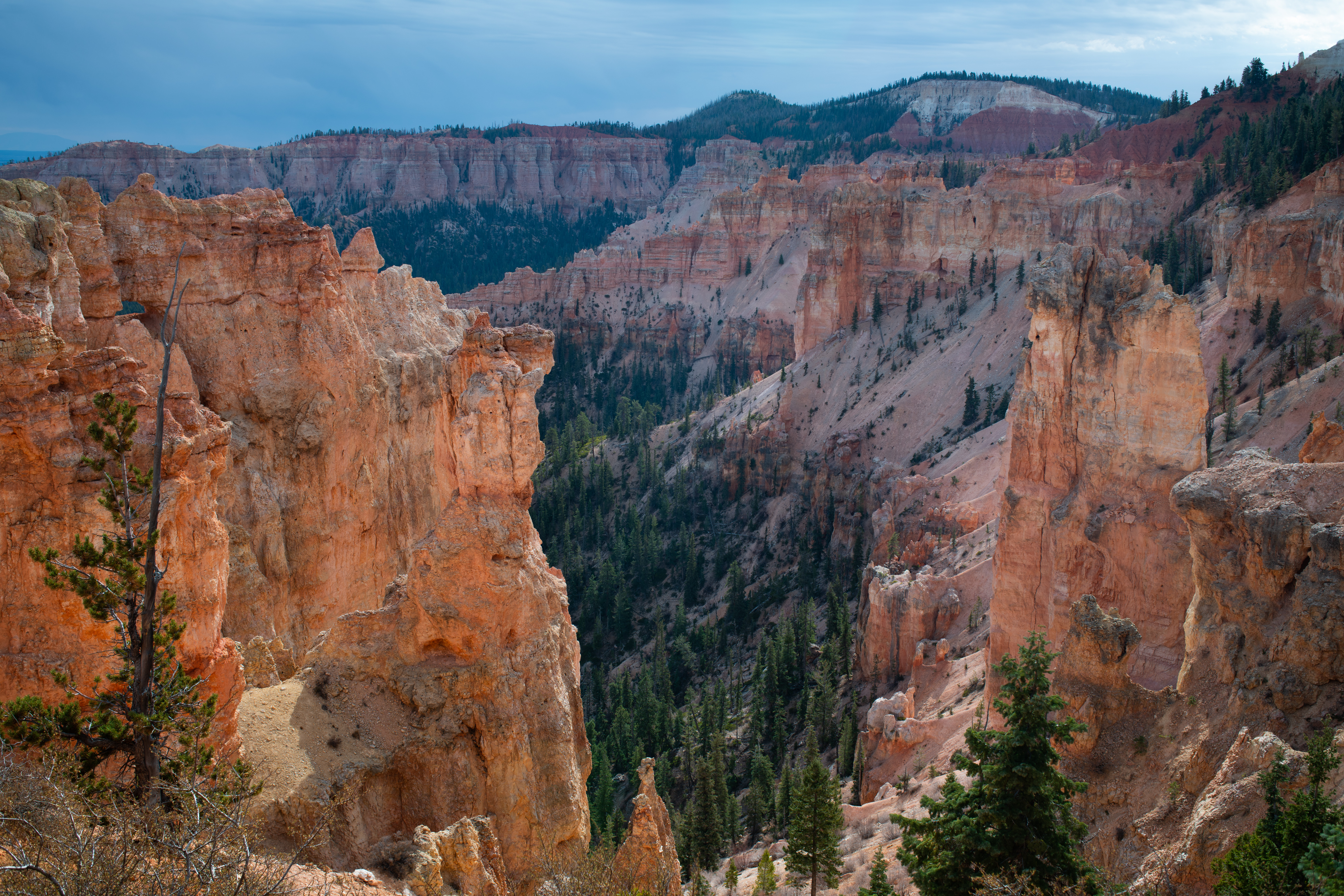
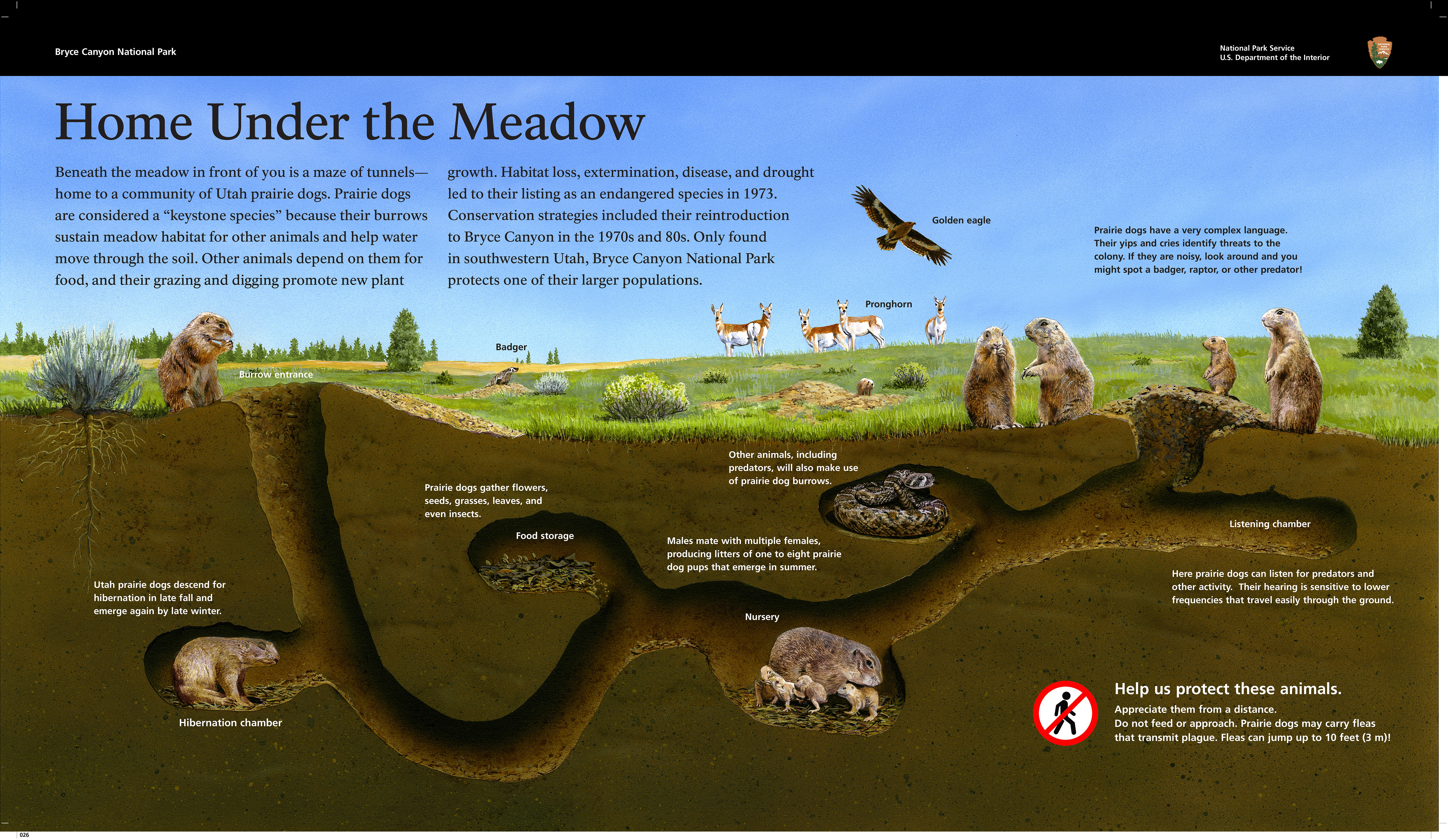
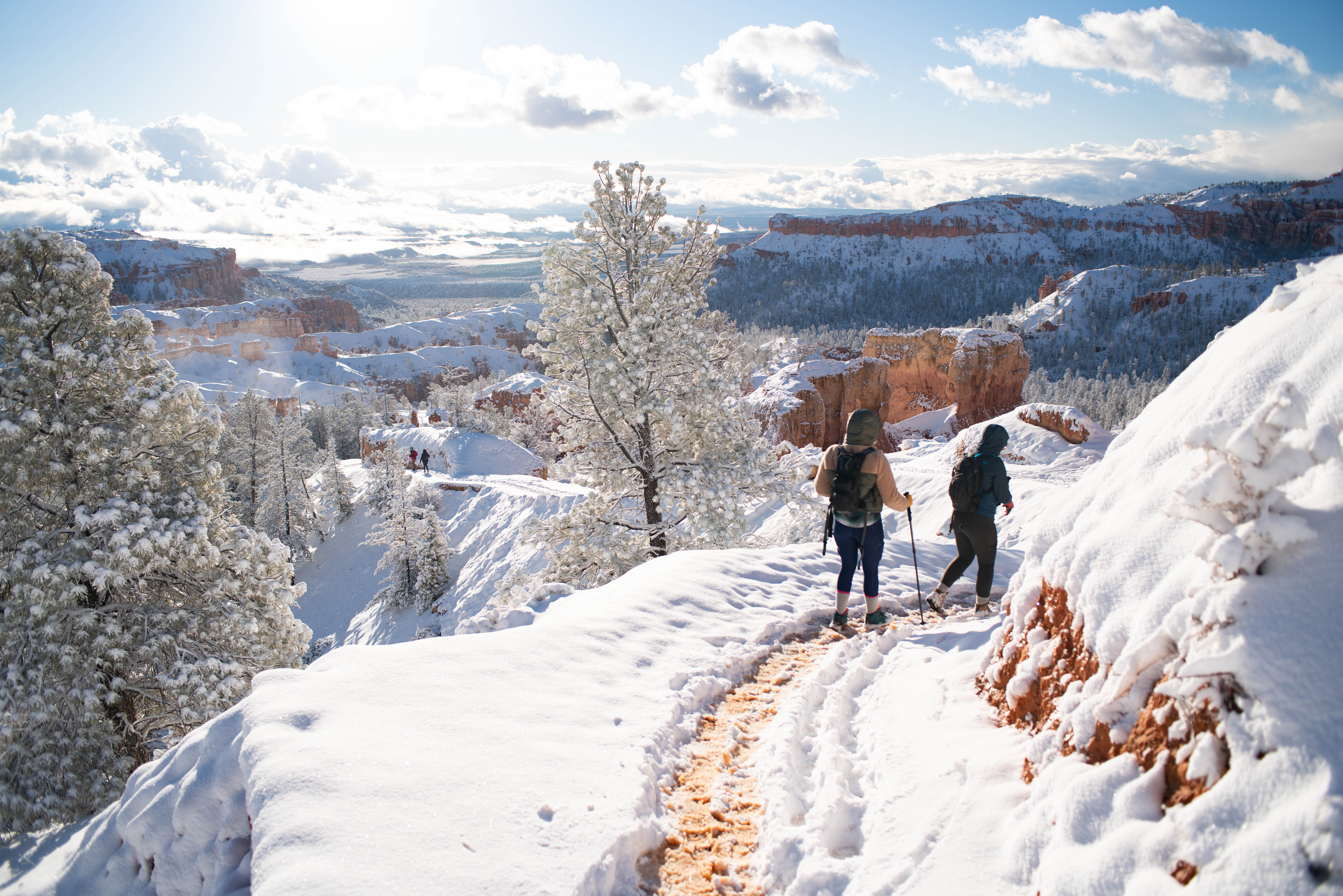
Hoodoos (irregular columns of rock) exist on every continent, but here is the largest concentration found anywhere on Earth. Situated along a high plateau at the top of the Grand Staircase, the park's high elevations include numerous life communi...
Admits one private, non-commercial vehicle (15 passenger capacity or less) and all occupants.
Entrance - Motorcycle
$30.00
Price is per motorcycle.
Entrance - Per Person
$20.00
Admits one individual with no car to the park - typically used for bicyclists and walk-ins. Youth 15 and under are admitted free.
Commercial Entrance - Sedan
$50.00
Commercial tour vehicle rates are based on vehicle capacity. Pass is valid for the day of purchase and the next six days for a vehicle carrying the same group of passengers.
A commercial tour is defined as consisting of one or more persons traveling on an itinerary that has been packaged, priced, or sold for leisure or recreational purposes by an organization that realizes financial gain through the provision of the service. The entry fees of commercial tours are based upon the total capacity of vehicles t
Commercial Entrance - Van
$50.00
Commercial tour vehicle rates are based on vehicle capacity. Pass is valid for the day of purchase and the next six days for a vehicle carrying the same group of passengers.
A commercial tour is defined as consisting of one or more persons traveling on an itinerary that has been packaged, priced, or sold for leisure or recreational purposes by an organization that realizes financial gain through the provision of the service. The entry fees of commercial tours are based upon the total capacity of vehicles t
Commercial Entrance - Mini-bus
$60.00
Commercial tour vehicle rates are based on vehicle capacity. Pass is valid for the day o
A commercial tour is defined as consisting of one or more persons traveling on an itinerary that has been packaged, priced, or sold for leisure or recreational purposes by an organization that realizes financial gain through the provision of the service. The entry fees of commercial tours are based upon the total capacity of vehicles that can carry seven or more passengers regardless of the actual number of passengers.
Commercial Entrance - Motor Coach
$150.00
Commercial tour vehicle rates are based on vehicle capacity. Pass is valid for the day of purchase and the next six days for a vehicle carrying the same group of passengers.
A commercial tour is defined as consisting of one or more persons traveling on an itinerary that has been packaged, priced, or sold for leisure or recreational purposes by an organization that realizes financial gain through the provision of the service. The entry fees of commercial tours are based upon the total capacity of vehicles.
North Campground is open year-round. You can find annual season dates and reservation information at go.nps.gov/BryceCamping
North Campground, four bulletins and one Rules & Regulations panel 136 words A ponderosa pine forest surrounds The North Campground, offering both sun and shade. The site is situated in a gently rolling landscape with various shrubs and summer wildflowers. Campground instructions, registration, regulations, informational bulletin boards, safety notices and maps are along a three-panel roofed kiosk at the entrance. the campground is located across the road to the East of the visitor center, within walking distance and contains 100 sites within 4 loop roads. The North campground has 50 RV sites and 46 tent-only sites. Campground has restrooms with flush toilets, picnic tables, drinking water, fire grates and quick access to an accessible shared use path. The North campground is closer to the general store than sunset campground. The Bryce Canyon Shuttle makes a stop nearby at the Visitor Center.
Sunset Campground is closed in winter. Annual season dates and reservation information can be found at go.nps.gov/BryceCamping
Sunset Campground + registration kiosk, 5 bulletins, 1 panel 171 words A ponderosa pine forest surrounds Sunset Campground, offering both sun and shade. The site is situated in a gently rolling landscape dotted with shrubs and summer wildflowers. Campground instructions, regulations, informational bulletin boards and campground maps are along a three-panel roofed kiosk at the entrance. The campground is located west of Sunset Point, 1.5 miles from the park's Visitor Center. There are 100 sites along three loop roads with gravel parking spurs, flush toilets and drinking water. Picnic tables and fire rings with grills are also provided. During the summer months, laundry and shower facilities are available at the general store nearby. The Bryce Canyon Shuttle makes a stop at the campground's entrance. This site is the closest in the park to many popular hiking trails that begin and end at Sunset Point. The campground has a campground host. Amenities include: 50 tent only sites, 46 RV sites, one group campsite, 2 ADA-accessible sites 1 group site. Restrooms with flush toilets, picnic tables, fire grates and a garbage and propane disposal area at the entrance.
On June 14, 2009, a lightning strike started the Bridge Fire that burned 3,947 acres in Bryce Canyon National Park and Dixie National Forest. Years of fire suppression had created a crowded, diseased, and less diverse forest. As the fire, a natural agent in the ecosystem, moved through this area, the forest was reborn. After the fire, nutrients were recycled back into the soil, sunlight reached the ground, and a variety of species returned.
A panel here at the Whiteman Picnic area interprets the 2009 Bridge fire, highlighting the benefits of wildland fire and the habitat that is created. We are surrounded by burned forest. Fallen and standing dead trees are blackened by fire and signs of new growth abound. The panel features a close-up photograph of Lewis’s Woodpecker perched on a pine branch. This large bird sized between a robin and a crow has a pink belly, gray collar, and dark green back and cap and red face with a long straight bill. Caption reads: Burned forests create habitat for a variety of wildlife. The Lewis’s woodpecker, shown here, favors open areas of burned forests for foraging, breeding, and nesting. Text continues: A Forest Reborn On June 14, 2009, a lightning strike started the Bridge Fire that burned 3,947 acres in Bryce Canyon National Park and Dixie National Forest. Years of fire suppression had created a crowded, diseased, and less diverse forest. As the fire, a natural agent in the ecosystem, moved through this area, the forest was reborn. After the fire, nutrients were recycled back into the soil, sunlight reached the ground, and a variety of species returned. It may look like destruction, but a closer look reveals new growth. Fire plays an essential role in forest health and regeneration. Inset photographs feature an aerial view of a burnt over section within the park and the adjacent national forest and the golden yellow leaves of young aspen saplings reclaiming the landscape. Captions read: Fire, when not suppressed, would occur here every five to 50 years, creating a mosaic pattern of burned and unburned areas Aspen are easily overshadowed, but sprout prolifically from underground root systems after a fire clears the overstory.
In 1933, during the Great Depression, President Franklin D. Roosevelt established the Civilian Conservation Corps (CCC) providing employment for young, unmarried men. From 1934–41, at Bryce Canyon National Park the CCC planted trees and shrubs, built and improved roads and trails, developed campgrounds, paved parking lots, and provided insect control. At Rainbow Point, they built the overlook structure and the Under-the-Rim Trail.
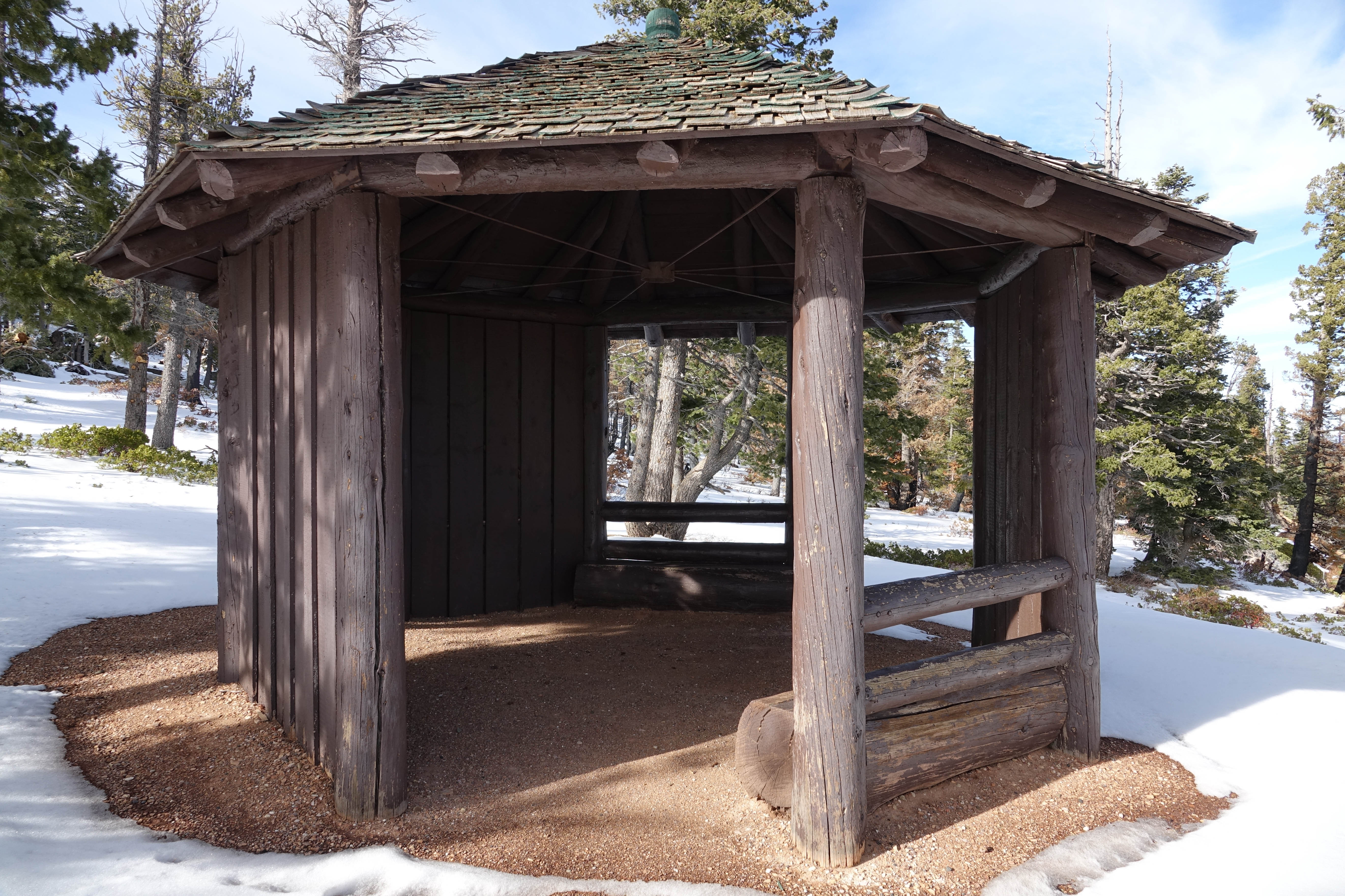
Two panels at the Rainbow Point Bristlecone Loop Shelter explain how the trails and this shelter were built, describe how volunteers are still maintaining the trails today and offer opportunities on how you can volunteer at our national parks. A small octagon shaped log shelter is near the overlook at Bristlecone loop. The gazebo is an open-air shelter on 5 sides. The interior is dirt floor. The rough sawn log frame of the shelter is painted dark brown. The roof is covered with overlapping green stained cedar shingles. The first panel: A Lasting Legacy, highlights black and white photographs taken in 1935 as the CCC Crew build a trail with pickaxes along the canyon edge and pose beside trucks and their equipment at the end of a day's work in the park. Text reads: In 1933, during the Great Depression, President Franklin D. Roosevelt established the Civilian Conservation Corps (CCC) providing employment for young, unmarried men. From 1934–41, at Bryce Canyon National Park the CCC planted trees and shrubs, built and improved roads and trails, developed campgrounds, paved parking lots, and provided insect control. At Rainbow Point, they built the overlook structure and the Under-the-Rim Trail. Their hard work created many improvements—a lasting legacy—enjoyed by visitors today. Two color photographs highlight the volunteers of today: as a crew in safety vests with survey equipment take measurements in the canyon and park crewmembers and volunteers work on habitat improvement projects for plants and animals in the open meadows at the forest edge. Text continues: Today’s conservation programs and groups continue this legacy. The Youth Conservation Corps, American Conservation Experience, and Utah Conservation Corps work with Bryce Canyon staff building boundary fences, improving natural habitat, and restoring backcountry and wilderness areas. Youth internship programs and volunteers assist with interpretation and education programs, forest management activities, and preventative search and rescue.
This additional parking lot is located just southeast of the Visitor Center and provides all-day and oversize vehicle parking.
A large parking lot with angled RV spaces and parallel parking spaces along its edge. A crushed stone path at its northwest corner leads to the northbound Visitor Center shuttle stop and a crosswalk leading to the Visitor Center. To the southeast, the parking lot links to the Shared Use Path adjacent to the kiosk for North Campground.
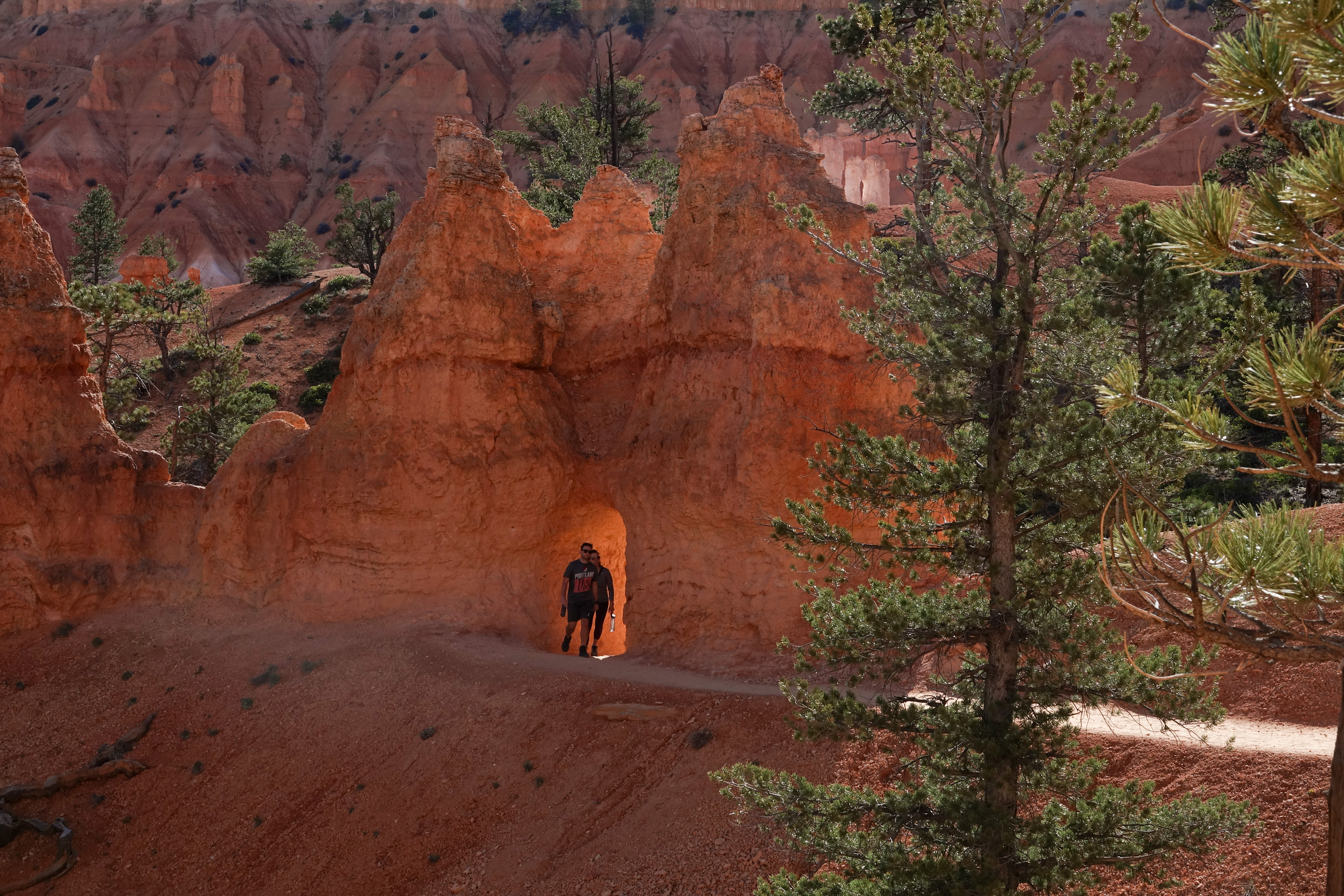
At Agua Canyon two prominent hoodoos command attention. On the left, is the taller of the two towers, "The Hunter." To the right is a hoodoo commonly referred to as the "Rabbit" or alternatively the "Backpacker."
Agua Canyon Overlook<br /><br />A sign at this overlook reads Agua Canyon Elevation 8800 ft.<br />There are two popular hoodoos seen from this overlook. The first, a tall stone pillar to the left known as The Hunter, seems to have the shape of a man in profile, a large bulbous head atop a smaller spire, he looks to the right at the rabbit Hoodoo, a strikingly white limestone rock shaped in the head of a rabbit with long vertical ears sits atop a narrow stone pillar, orange in color. On the distant horizon is the soft purple silhouette of Navajo Mountain.
Trail Closed due to Rockslide This trail descends 1.6 miles (4.0 km) to its junction with the Under the Rim Trail approximately 1,000 feet (305 m) below.
Agua Canyon Connecting Trail Trailhead at Ponderosa Point<br /><br />A sign stating that this trail is closed due to rockslide stands across the trail.
Here, the Agua Canyon Connecting Trail descends to the rugged 22.9-mile (36.9 km) Under-the-Rim backcountry trail, which travels north to Bryce Point and south to Rainbow Point. Day hikers can enjoy an out-and-back hike with views of Agua Canyon and the Paria Valley beyond.
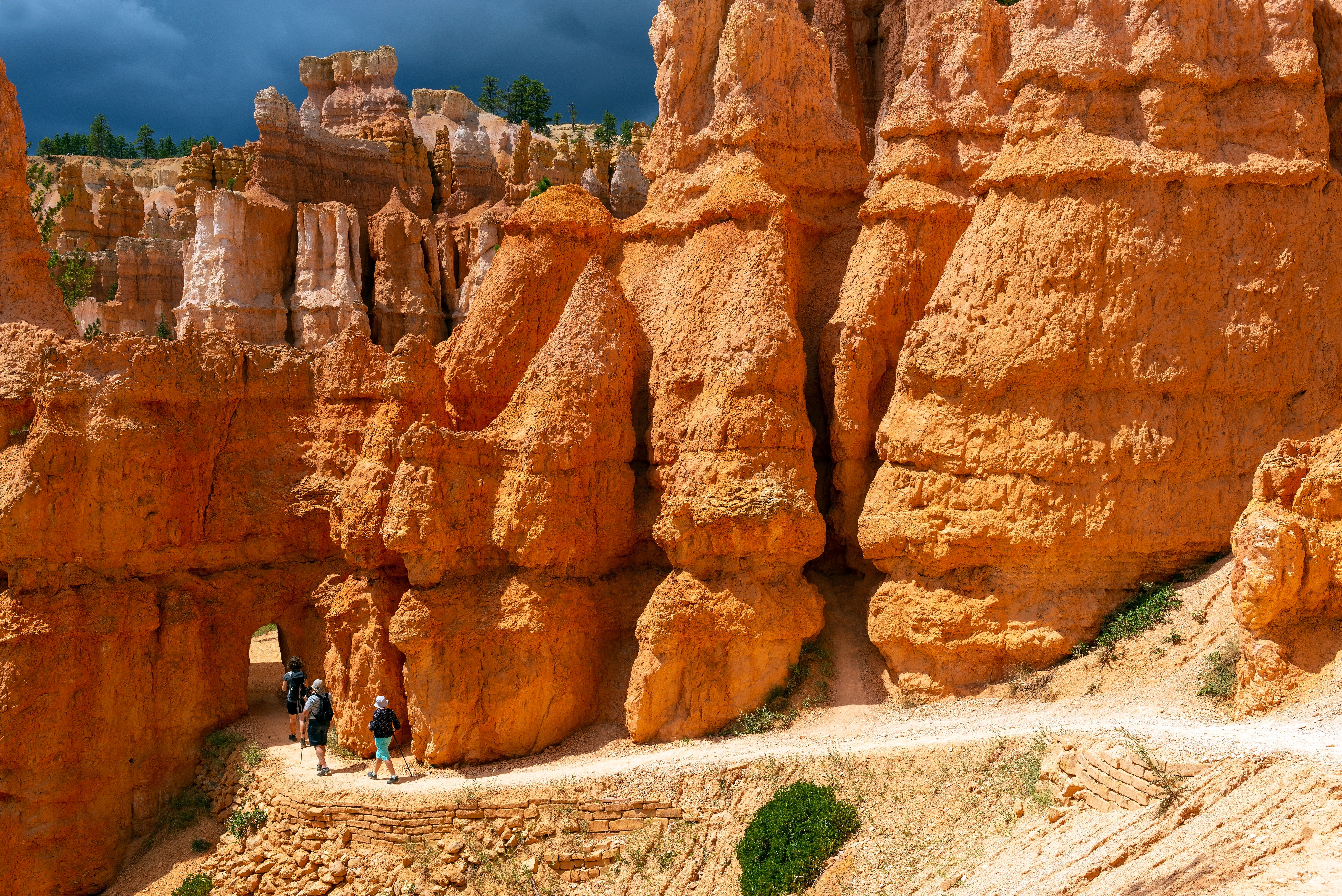
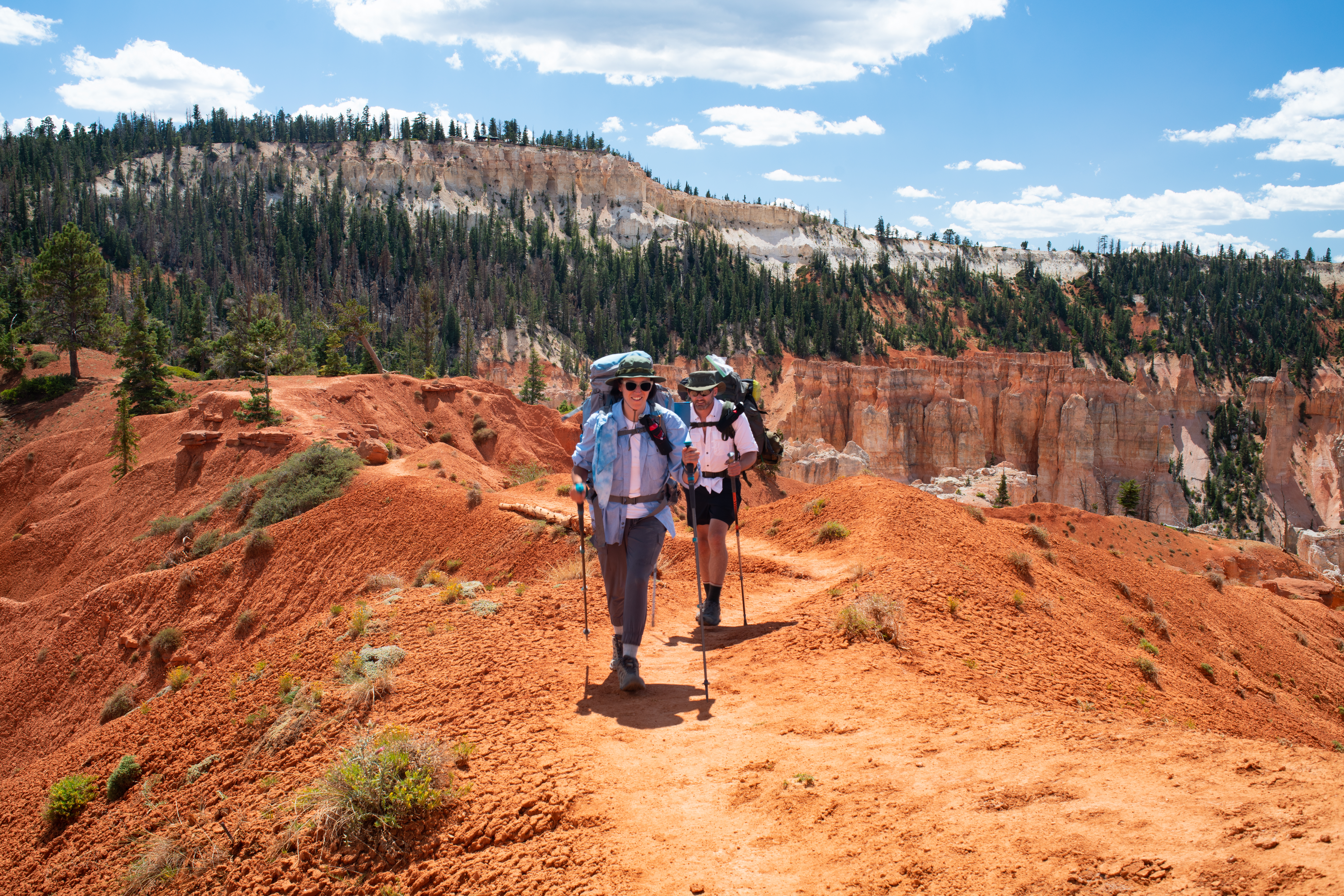
Agua Canyon Trail Connections There are two popular hoodoos seen from this overlook at Agua Canyon trailhead. The first, a tall stone pillar to the left known as The Hunter appears to have the shape of a man in profile, a large bulbous head atop a smaller spire, he looks to the right at the rabbit hoodoo, a strikingly white limestone rock shaped in the head of a rabbit with long vertical ears sits atop a narrow stone pillar, orange in color. On the distant horizon is the soft purple silhouette of Navajo Mountain. A map illustrates that we are at Ponderosa Canyon and a graphic provides details about the trail: Agua Canyon Connecting Trail 1.6 miles (2.6 km) Difficulty: Strenuous Total Descent: 1,000 feet (244 m) A photograph along the bottom of the panel shows two hikers heading into the canyon along the narrow trail. Steep terra cotta-colored embankments surround them. Text Continues: Here, the Agua Canyon Connecting Trail descends to the rugged 22.9-mile (36.9 km) Under-the-Rim backcountry trail, which travels north to Bryce Point and south to Rainbow Point. Day hikers can enjoy an out-and-back hike with views of Agua Canyon and the Paria Valley beyond. Backcountry Information: The park backcountry offers rugged terrain for adventurous hikers seeking a less-traveled trail. We recommend strong wayfinding tools and skills. Response to emergency situations may be difficult and delayed.
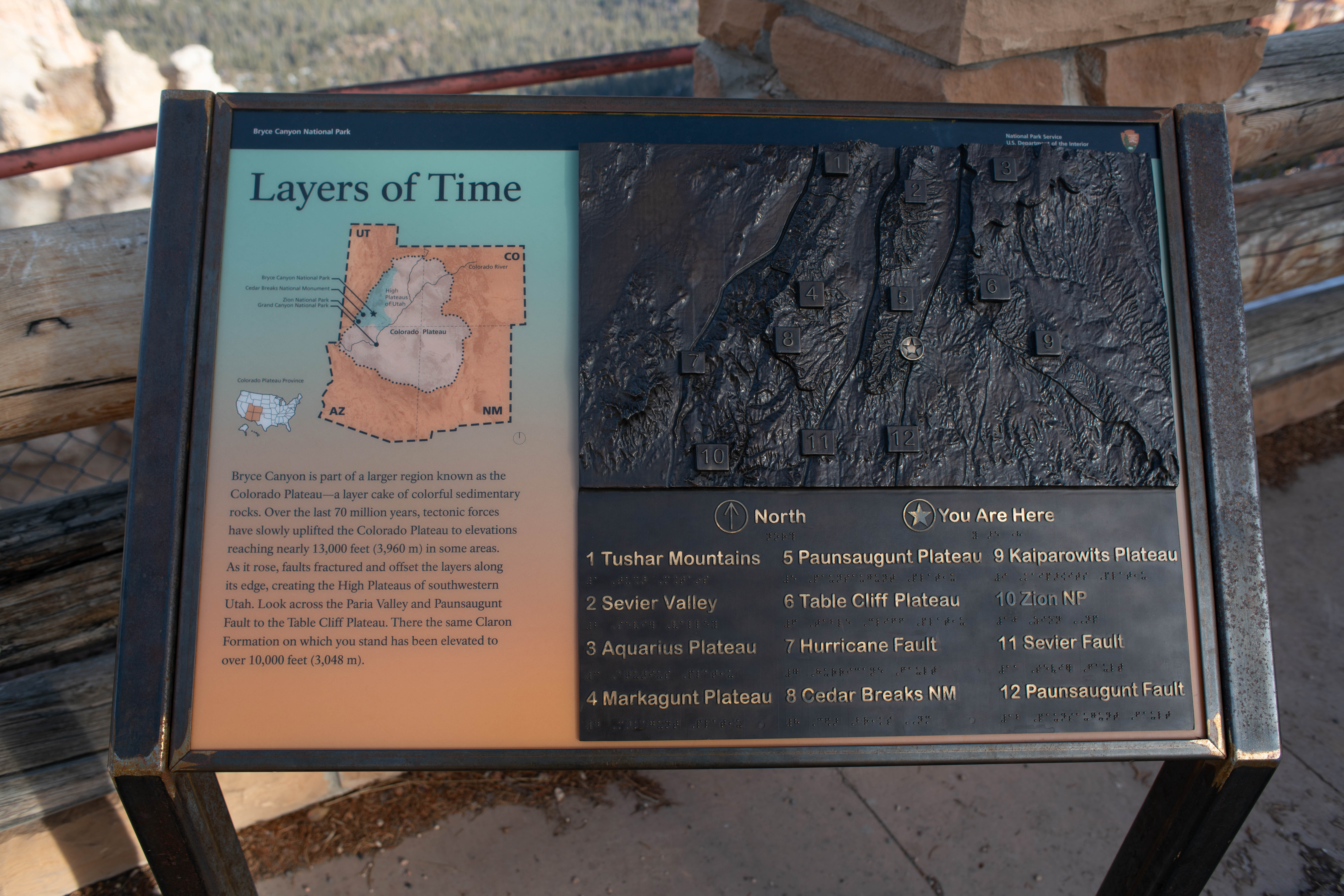
Bryce Canyon is known for its stunning views and vistas. On a clear day from this point you can see Navajo Mountain, 80 miles (129 km) away, and the San Francisco Peaks, 150 miles (241 km) south. Good air quality, one of the park’s most precious resources, makes these views possible. It is also essential for visitor and employee health and the well-being of the natural environment.
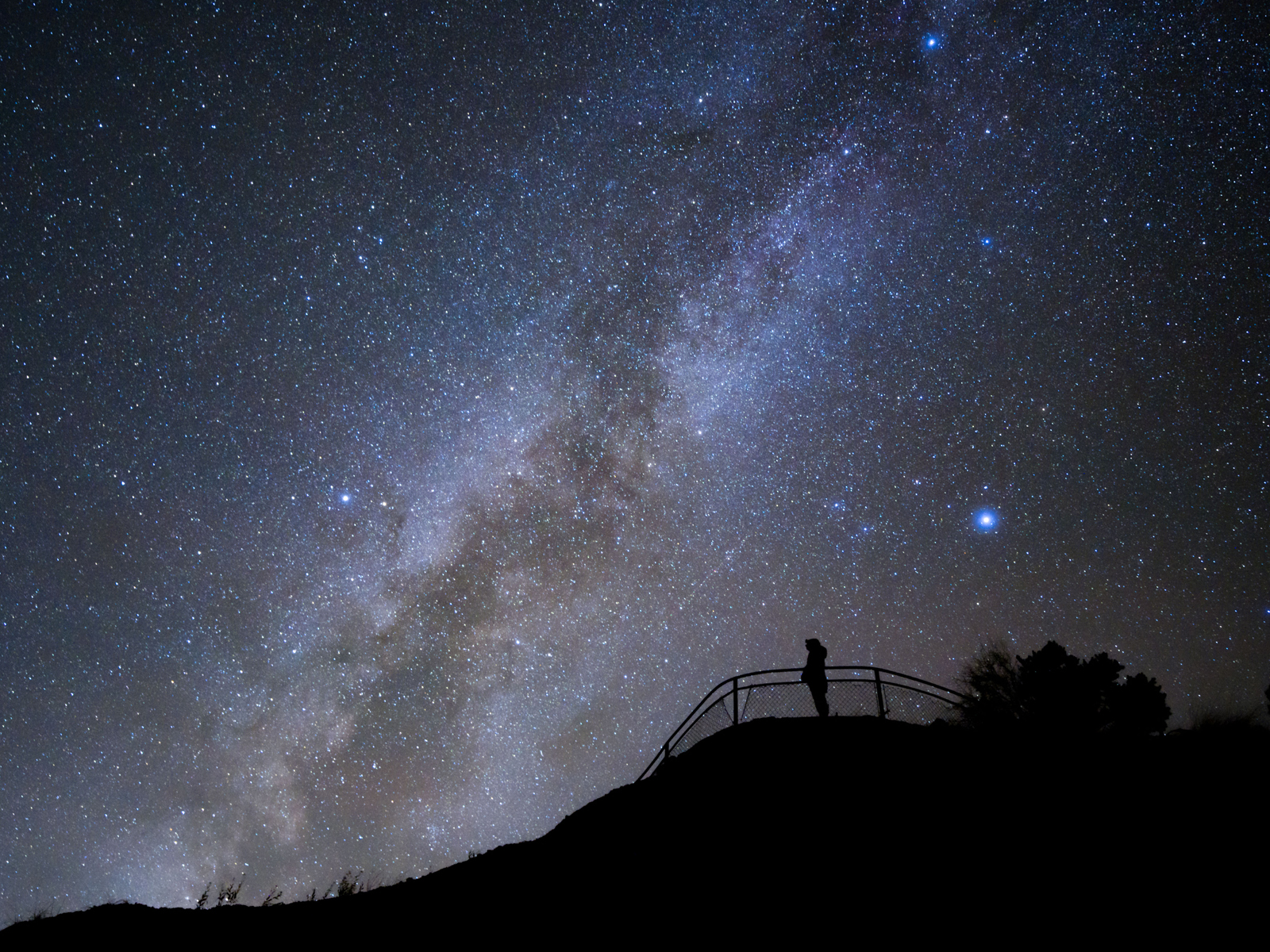
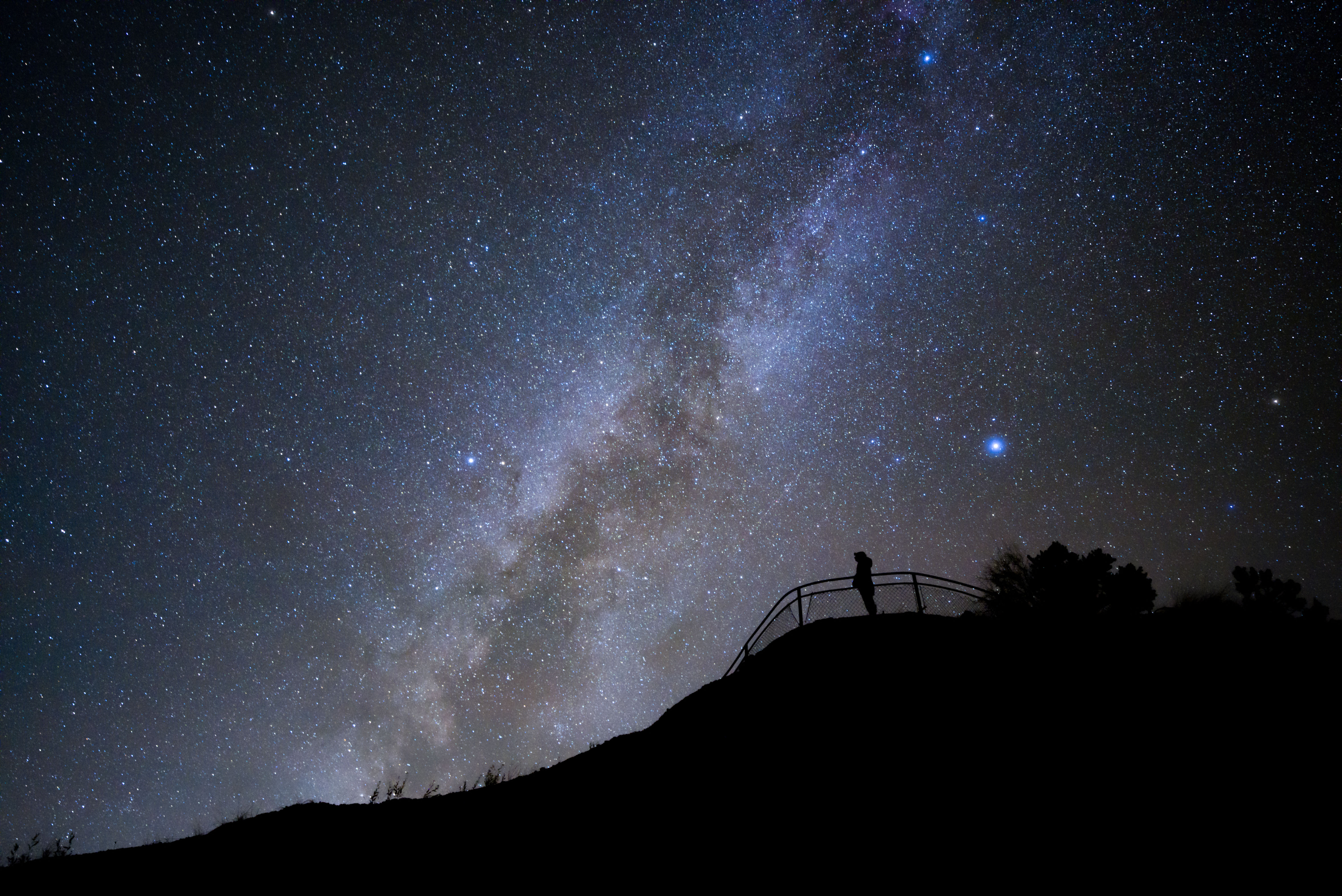
A photograph shows a clear view of the dome shaped Navajo Mountain. Title and text continue: Pristine Views and Vistas Bryce Canyon is known for its stunning views and vistas. On a clear day from this point you can see Navajo Mountain, 80 miles (129 km) away, and the San Francisco Peaks, 150 miles (241 km) south. Good air quality, one of the park’s most precious resources, makes these views possible. It is also essential for visitor and employee health and the well-being of the natural environment. An inset map caption reads: This map provides a look at air quality across the United States. The darkest areas, like the area surrounding Bryce Canyon, indicate the best recorded air quality. Text Continues: The park began monitoring air quality in 1985 and works to address air quality issues by working with scientists to plan and incorporate clean air practices. An air quality webcam here records and shares daily conditions, including visibility, ozone levels, air particles, and weather. A photograph of Bryce Canyon at night shows the popular hoodoo Thor’s Hammer against a backdrop of a brilliant night sky filled with stars. Caption reads: Bryce Canyon, an International Dark Sky Park, preserves and protects night sky views through public education and responsible lighting policies.
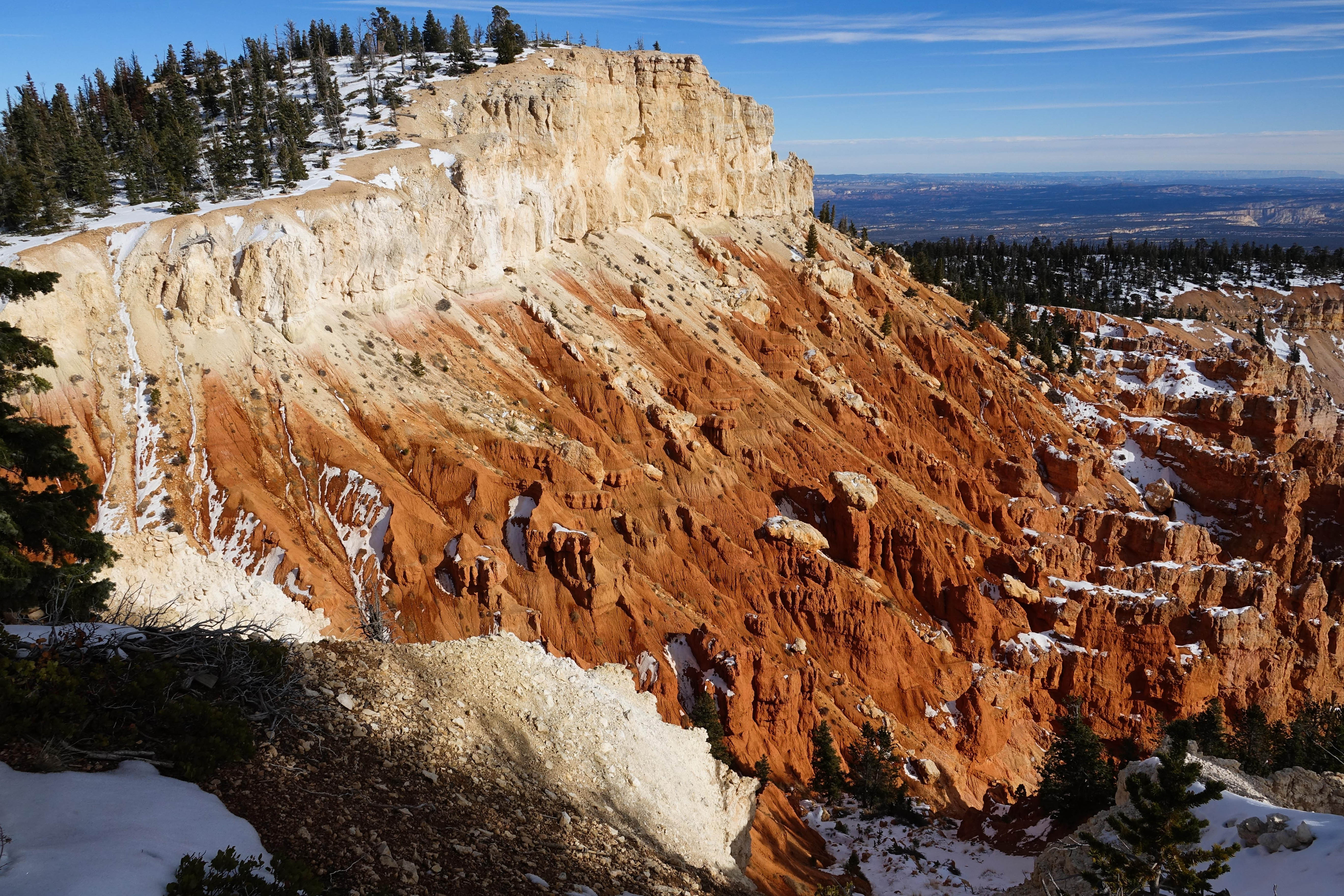
Colorful Layers Pure limestone is white, but here, iron deposits have oxidized, or rusted, producing the yellows, oranges, reds, and browns. Oxidized manganese creates the pale blue and purple hues. Changing weather and light also affect the canyon’s colors. Bryce Canyon is ever-changing. About 50 million years ago (mya), a large freshwater lake began filling the low basin of southern Utah. Over millions of years, rivers and streams gradually filled this lake.
Two exhibits are on the wall of the shelter to explain how the processes of deposition, uplift and erosion created these formations and to interpret the three life zone communities found in the park. The first: An Ever-changing Landscape A panoramic photograph spans the panel to highlight the variety of colors and the varied shades of color found in the park's landscape. Caption reads: Colorful Layers Pure limestone is white, but here, iron deposits have oxidized, or rusted, producing the yellows, oranges, reds, and browns. Oxidized manganese creates the pale blue and purple hues. Changing weather and light also affect the canyon’s colors. Three diagrams illustrate the forces at work on the landscape over millions of years. The first diagram shows the area underwater. Caption Reads: Once a Lake 50 mya Text continues: Bryce Canyon is ever-changing. About 50 million years ago (mya), a large freshwater lake began filling the low basin of southern Utah. Over millions of years, rivers and streams gradually filled this lake with clays, silts, and sands. Calcium carbonate cemented these sediments together, forming Bryce Canyon’s colorful, sedimentary rock layers. Meanwhile, tectonic forces deep within the Earth, were moving, cracking, and lifting, transforming the surface. The next diagram illustrates the exposure of the lake sediments then uplift and separation of the region along a Faultline. Caption reads: Uplift 20mya Text continues: About 20 mya a series of plateaus were uplifted along faults—large cracks in the Earth’s crust. The Paunsaugunt Plateau, on which you are standing, rose from near sea level to an average of 8,000 feet (2,440 m). To the east, Table Cliff rose 2,000 feet (610 m) higher. Around six mya the Paria River began carving a broad valley between the Table Cliff and Paunsaugunt plateaus. The last diagram illustrates a rugged and carved out landscape caused by weathering and erosion 6mya to present day Text continues: Weathering and Erosion Both mechanical and chemical weathering shape this place. At this high elevation, temperatures fall below freezing around 180 nights a year. Water seeps into rock fractures and then expands as it freezes, wedging rocks apart bit by bit. Chemical weathering occurs as acids in the water dissolve the calcium carbonate that holds the rocks together. Melting snow and summer rains wash away the rock debris, eroding the weathered stone A prominent hoodoo named Thor’s hammer is at the center of the image with hundreds more hoodoos of varying shapes and sizes in the near and far distance. Text continues: Shaping Hoodoos Bryce Canyon’s hoodoos are rock pinnacles shaped by weathering and erosion. Often topped by an erosion-resistant caprock—such as dolomitic limestone—each hoodoo consists of rock layers that erode at different rates. This process of differential erosion creates the whimsical shapes, which will eventually collapse.
Gilbert Stanley Underwood, the master architect hired by Union Pacific Railroad, helped pioneer the National Park Service rustic style. Here at Bryce and at many other western national parks, his artistry, vision, and utilization of local timber and stone created structures that nestled harmoniously into the natural landscape.
Architectural Artistry This panel along Lodge entrance interprets the history of the Lodge as being the last original lodge of those designed by Gilbert Stanley Underwood along the Union Pacific's "Grand Circle" tour. A black and white photograph taken in 1938 shows the front of the original lodge with a long line of buses lined up to take visitors on park tours. Text reads: Architectural Artistry Gilbert Stanley Underwood, the master architect hired by Union Pacific Railroad, helped pioneer the National Park Service rustic style. Here at Bryce and at many other western national parks, his artistry, vision, and utilization of local timber and stone created structures that nestled harmoniously into the natural landscape. The lodge’s roof is notable. Its green color was chosen to blend in with the Ponderosa pines, and the shingle pattern creates a wave-like movement, mimicking pine boughs blowing in the wind. This is the last remaining original “Grand Circle Tour” lodge. A hand drawn map from 1930 illustrates this grand circle tour by road, bus, and train connections among Zion, Bryce, Cedar Breaks, and Pipe Spring. Caption reads: Enticing tourists to lengthen their stay, the Utah Parks Company created the "Grand Circle Tour,” a bus trip through Cedar Breaks, Bryce Canyon, the Kaibab Plateau, Grand Canyon North Rim, and Zion national parks and monuments. Text continues: The original lodges at Zion and Grand Canyon burned down, and Cedar Breaks' was dismantled. The lodge at Bryce Canyon is the last remaining from the Grand Circle Tour era Description of the Lodge follows: This two-story building is irregularly shaped with a hipped roof structure. It is made of stone and exposed wood framing. The steeply pitched roofs are finished with wood shingles applied in a wavy pattern. Each corner of the building is anchored by sandstone pillars. Stone chimneys are located at various points and protrude above the roof line. The main entrance to the lodge features columns and log beam work along a long porch. Three centrally located staircases access the patio directly in front of the main entrance. Each step down to the road and connect with a trail that takes you to the Canyon rim. The patio is enclosed by a large diameter log railing set in stone piers that run the length of the front of the building. The patio is paved with red clay brick in a variety of patterns. The wood siding and exposed frame of the lodge are painted dark brown. The lodge and most other buildings in the area were designed in the rustic style using local stone and wood, with detailing to make the buildings look as if they had been constructed with primitive hand tools to ensure a natural look with the surrounding environment.
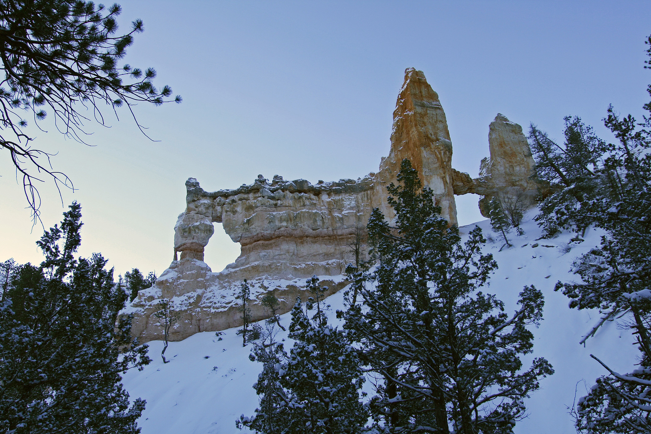
The park has its share of misnomers (Mossy Cave isn't a cave, the canyon isn't really a canyon...) and Black Birch Canyon would be another.
Black Birch Canyon Overlook<br /><br />Pine and fir trees surround the walkway to the overlook. A path runs adjacent to the plateaus edge and is enclosed with a horizontal log railing.<br />A sign at this overlook reads Black Birch Canyon Elevation 8750 feet.<br />Rows of striking orange pillar shaped hoodoos line the edges of the plateau as trees creep up along the sides of the cliff edges. The overlook provides a view of Rainbow point to the north. In the distance is Powell Point-the southernmost extent of the Table Cliff Plateau-and to the right are the distant Henry Mountains.
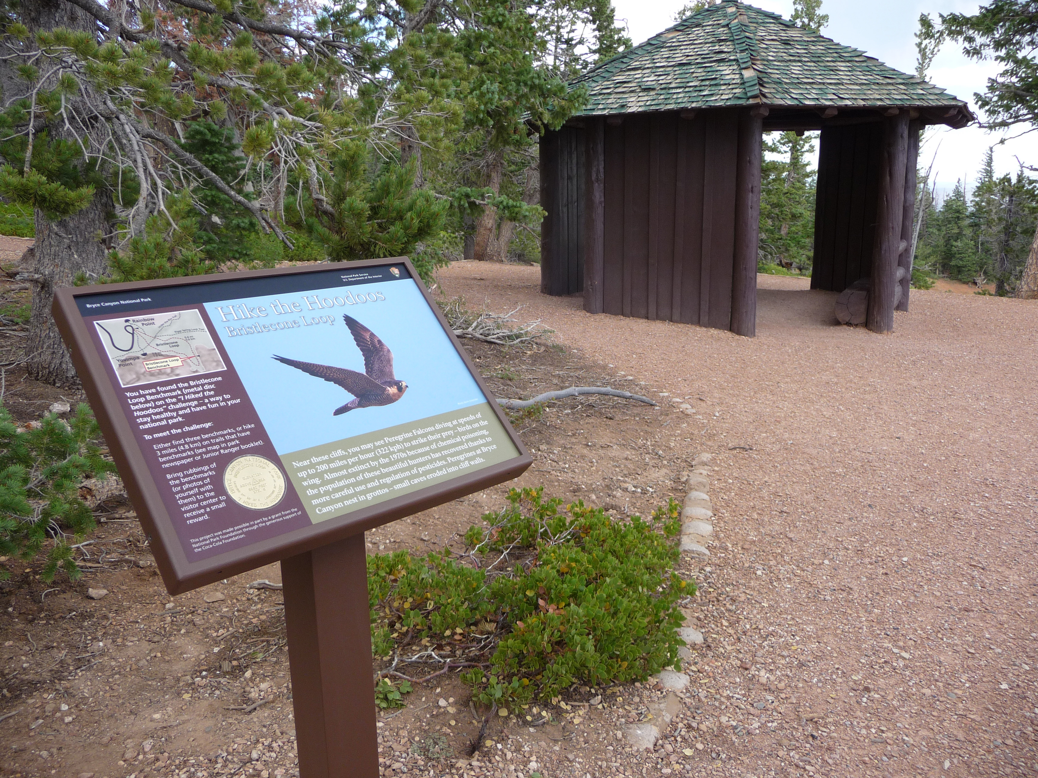
A small octagon shaped log shelter built by the park in the 1980s after the Bristlecone Loop was completed. At this point in the trail you might recognize smaller bristlecone pines nearby. Look for densely bunched needles travelling in a bushy arrangement up the branch. Needles will be in bundles of 5. Two quotations by Henry David Thoreau are framed on the interior wall of the shelter. The first: Silence alone is worth being heard, then "I need solitude. I have come forth to
A small octagon shaped log shelter built by the Civilian Conservation Corps is near the overlook at Bristlecone loop. The gazebo is an open-air shelter on 5 sides. The interior is dirt floor. The rough sawn log frame of the shelter is painted dark brown. The roof is covered with overlapping green stained cedar shingles. Two quotations by Henry David Thoreau are framed on the interior wall. The first: Silence alone is worth being heard, then "I need solitude. I have come forth to this Hill to see the forms of the mountains on the horizon too beholden commune with something grander than man. "
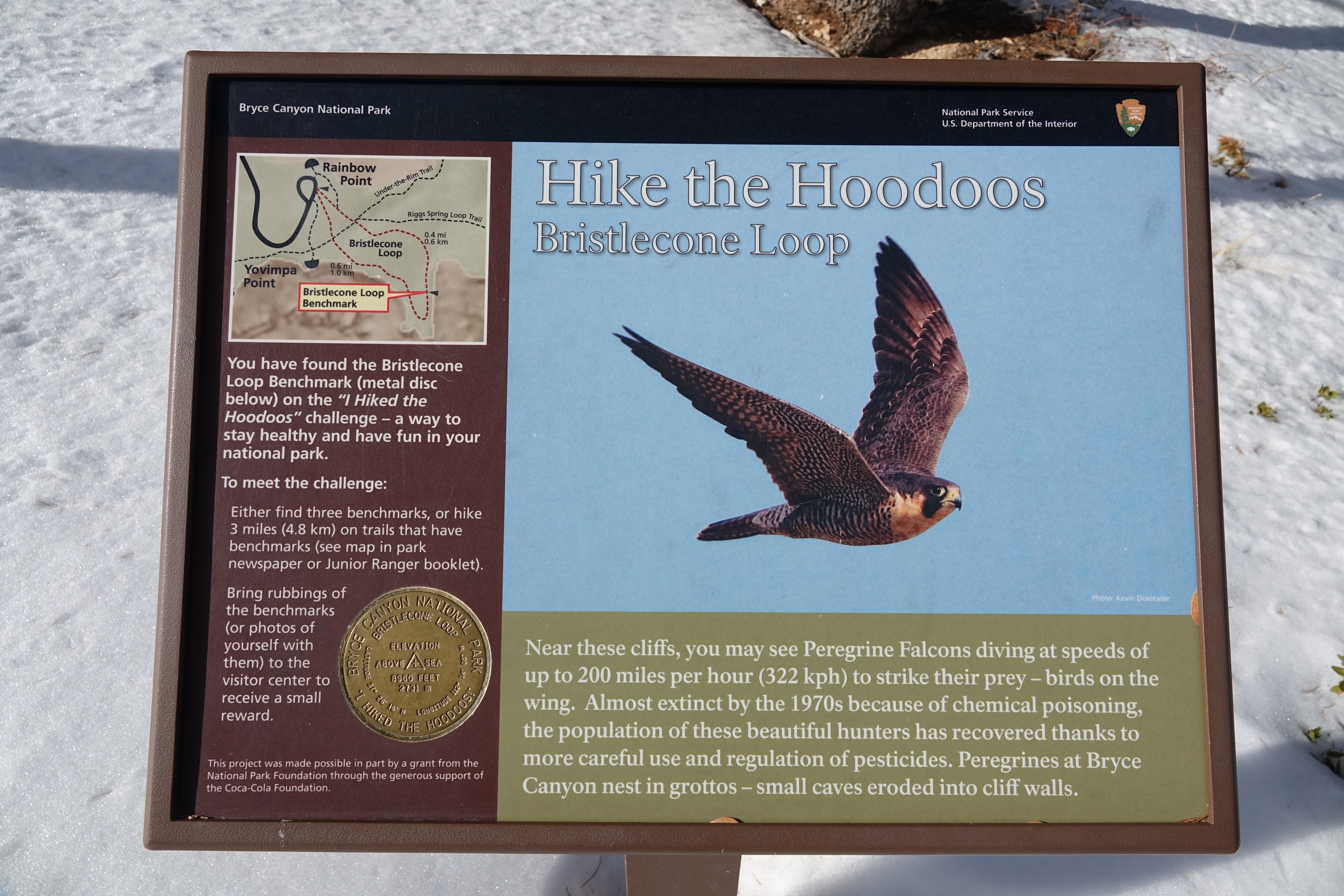
Hike the Hoodoos Hiking is great exercise and Bryce Canyon's "I Hiked the Hoodoos!" program is not just hiking, it's also a scavenger hunt with a special reward!
Hike the Hoodoos -Bristlecone Loop wayside <br /><br />Bristlecone Loop: This Panel is found beside the historic Civilian Conservation Corps gazebo along the Bristlecone Loop trail. It faces north and is placed in a flat area of natural sediment. Behind are tall eroded pink cliffs of Bryce Canyon's Claron formation.
A short path through fir and pine leads to the easy 1.0 mi/1.6 km Bristlecone Loop, as well as the 8.8 mile (14.2 km) backcountry Riggs Spring Loop and 23 mile (37 km) Under-the-Rim Trail. Though the Bristlecone Loop trail only climbs 200 feet (61 m) and is rated as Easy, be sure to carry water, wear ankle-supporting footwear, and postpone your hike if lightning is expected.The Bristlecone Loop reaches elevations over 9,100 feet (2778 m). Here you will pass by bristlecone pin
Bristlecone Loop Trail wayside (Yovimpa) 223 words<br /><br />An upright panel titled Bristlecone loop trail displays a map of the trails in this vicinity from the Rainbow Point overlook. A "you are here" marker shows our location at the trailhead overlook at Rainbow Point. The trail loops back to this location and is 1 mile in length. There are trailside exhibits along the way. A secondary trail, the Riggs Spring Loop Trail intersects the Bristlecone loop. Map Caption reads: This trail stays entirely above the Canyon rim a shady contrast to the red rock trails below. The one mile loop pass Passes through dense fir forest to an exposed viewpoint where bristlecone pine trees survive the wind. <br /><br />A hand drawn illustration below the map shows a very old bristlecone pine tree with a large twisted and furrowed trunk. Text reads: Forest in the sky<br />At the highest point in the park, fir trees dominate the forest, thriving in heavy snow and extreme temperatures. A short distance down the trail the air becomes noticeably cooler snow patches linger late into spring, Out on the point where soil becomes thin an exposure is more severe, the bristlecone Pines survive better than fir trees and other plants. This particular forest is no longer typical of the high plateau. There is evidence all along the trail that natural fires have not burned here for decades.
A short path through fir and pine leads to the easy 1.0 mi/1.6 km Bristlecone Loop, as well as the 8.8 mile (14.2 km) backcountry Riggs Spring Loop and 23 mi/37 km Under-the-Rim Trail.
Bristlecone Loop Trail wayside "(Yovimpa)<br /><br />An upright panel titled Bristlecone loop trail displays a map of the trails in this vicinity from the Rainbow Point overlook. A "you are here" marker shows our location at the trailhead overlook at Rainbow Point. The trail loops back to this location and is 1 mile in length. There are trailside exhibits along the way. A secondary trail, the Riggs Spring Loop Trail intersects the Bristlecone loop. Map Caption reads: This trail stays entirely above the Canyon rim a shady contrast to the red rock trails below. The one mile loop pass Passes through dense fir forest to an exposed viewpoint where bristlecone pine trees survive the wind. <br /><br />A hand drawn illustration below the map shows a very old bristlecone pine tree with a large twisted and furrowed trunk. Text reads: Forest in the sky<br />At the highest point in the park, fir trees dominate the forest, thriving in heavy snow and extreme temperatures. A short distance down the trail the air becomes noticeably cooler snow patches linger late into spring, Out on the point where soil becomes thin an exposure is more severe, the bristlecone Pines survive better than fir trees and other plants. This particular forest is no longer typical of the high plateau. There is evidence all along the trail that natural fires have not burned here for decades.
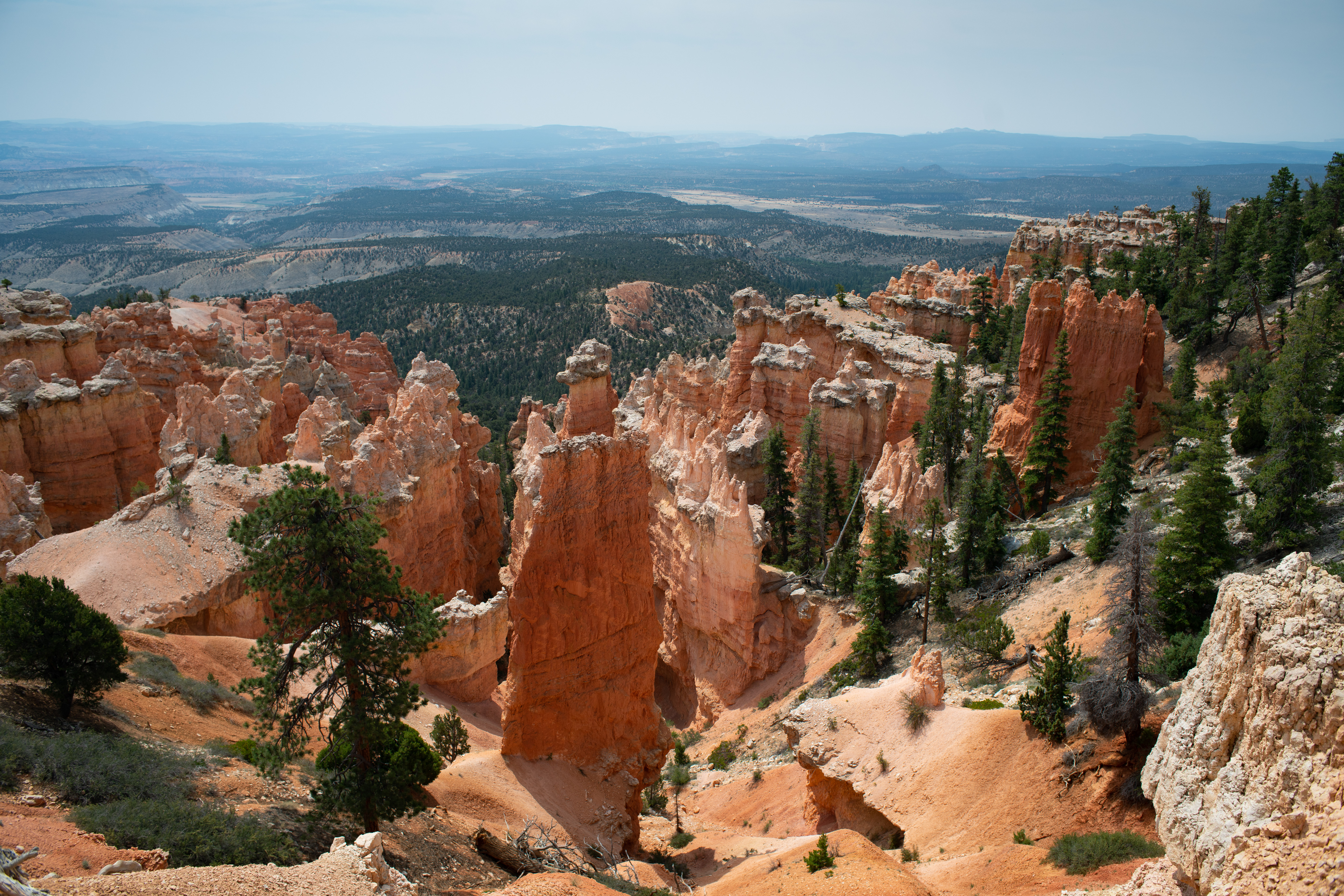
This trail takes you through a forest of white fir, Douglas-fir, limber pine, and ponderosa pine. Bristlecone pines—some over 1,000 years old—grow at the trail's southern end where hikers enjoy grand views to the south. Small mammals and a variety of birds, including woodpeckers, nuthatches, and peregrine falcons might be spotted. In winter months, this trail may be impassable due to deep snow.
Three orientation panels at different access points here at Rainbow Point provide details about hiking the Bristlecone Loop Trail. A map illustrates the location of the trail and a graphic provides details about the trail: Length: 1.0 mile (1.6 km) Difficulty: Easy Total Ascent: 200 feet (61 m) A photograph along the bottom of the panel shows one of the many scenic vistas along the trail while an inset photograph highlights another experience, walking along the narrow path with dense forest on either side. A bronze coin-shaped medallion on the panel signals that One “Hike the Hoodoos” medallion is found along this trail. Find it, then take a photo or rubbing. When you’ve found three different medallions or hiked 3 miles (4.8 km) on trails that have benchmarks (see Visitor Guide) take them to the visitor center for a reward. Text continues: Bristlecone Loop Trail This trail takes you through a forest of white fir, Douglas-fir, limber pine, and ponderosa pine. Bristlecone pines—some over 1,000 years old—grow at the trail's southern end where hikers enjoy grand views to the south. Small mammals and a variety of birds, including woodpeckers, nuthatches, and peregrine falcons might be spotted. In winter months, this trail may be impassable due to deep snow.
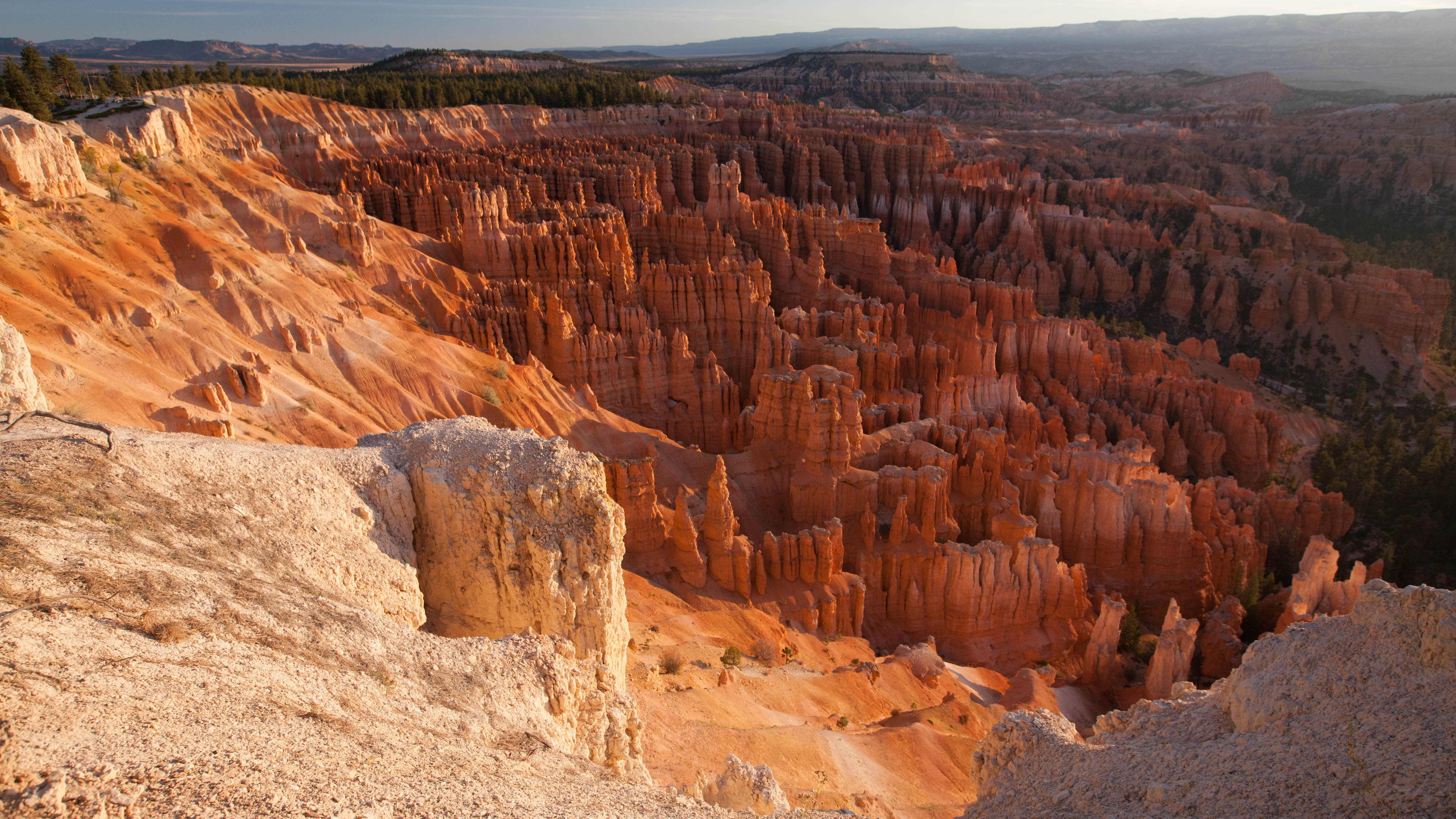
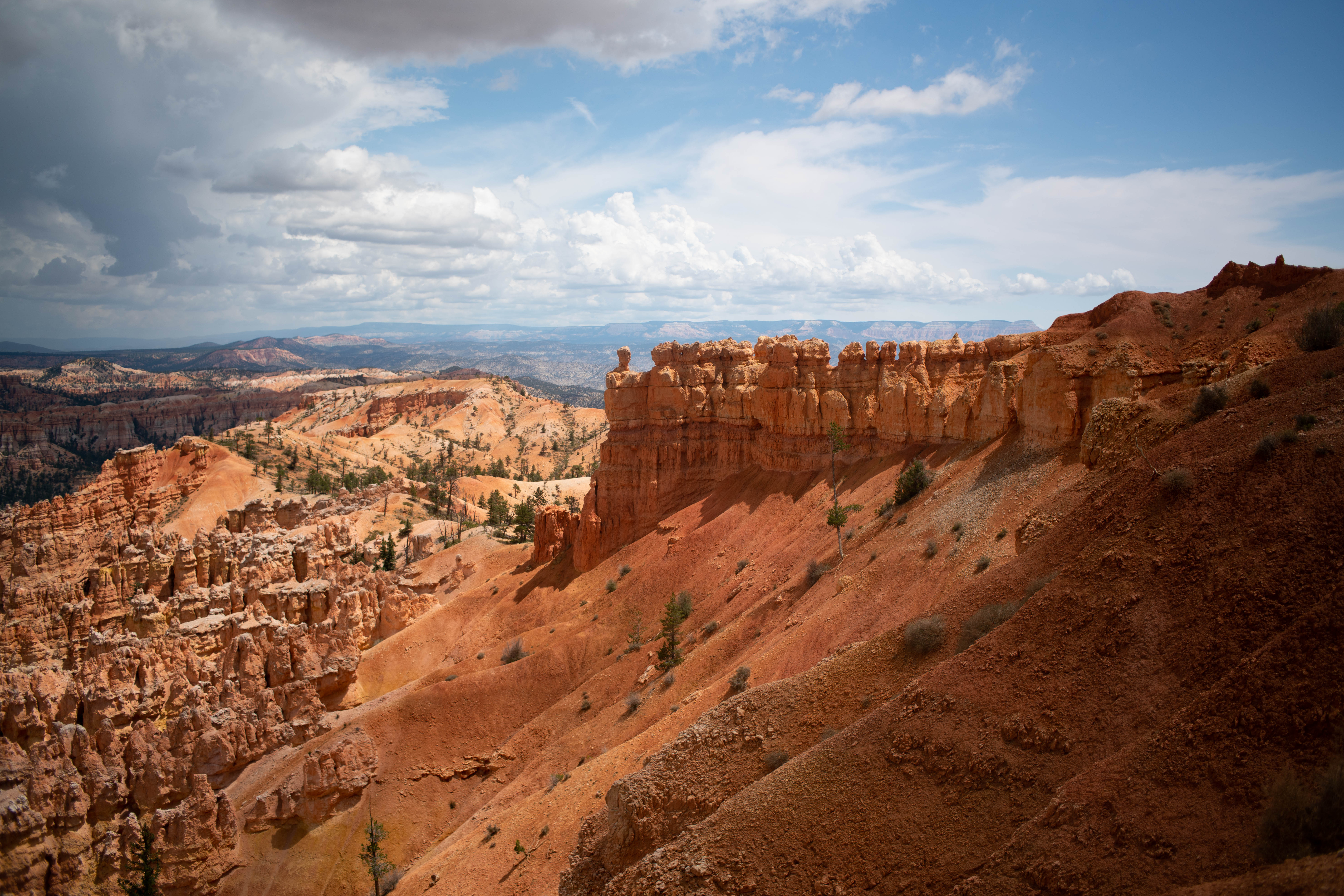
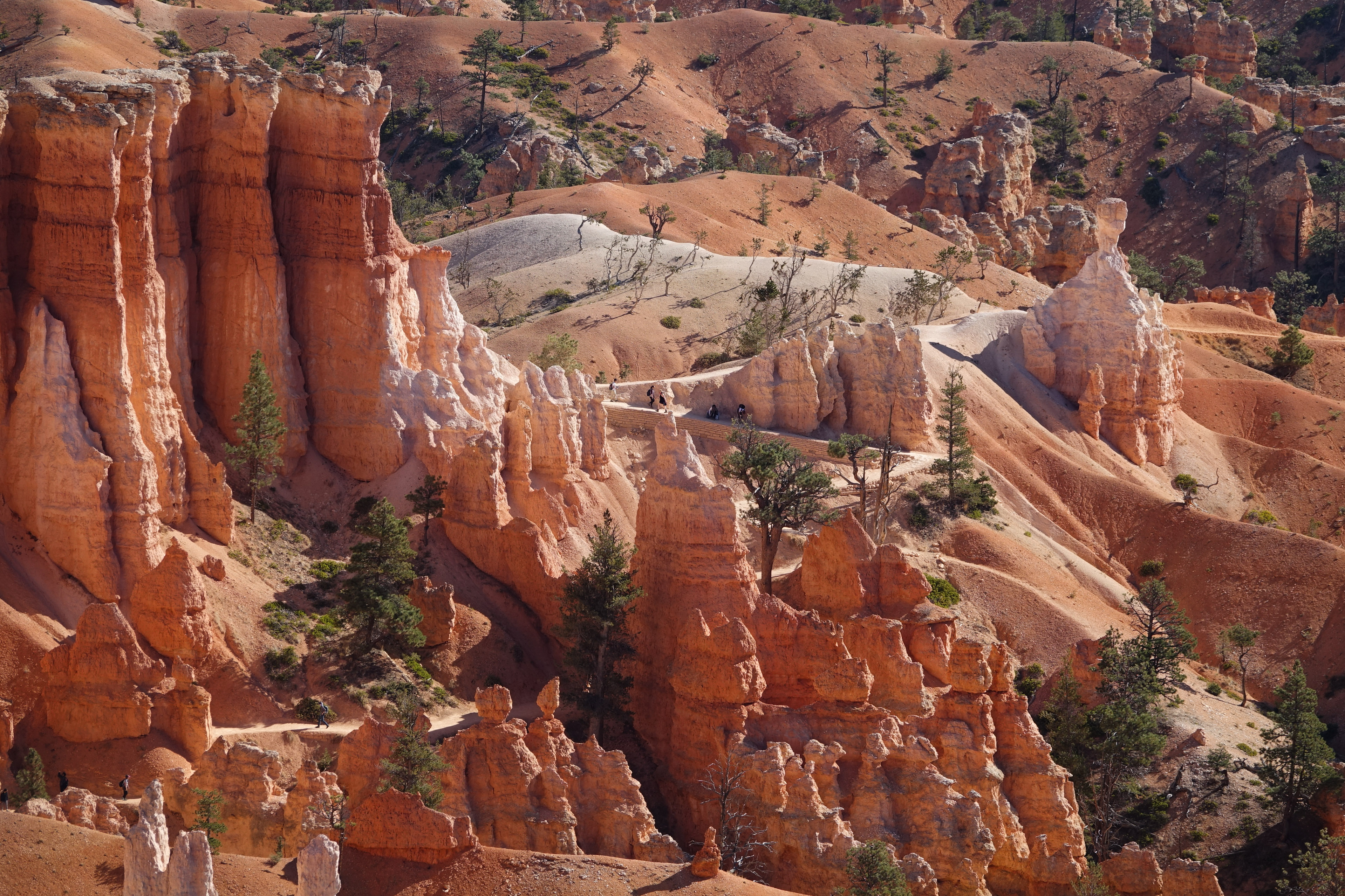
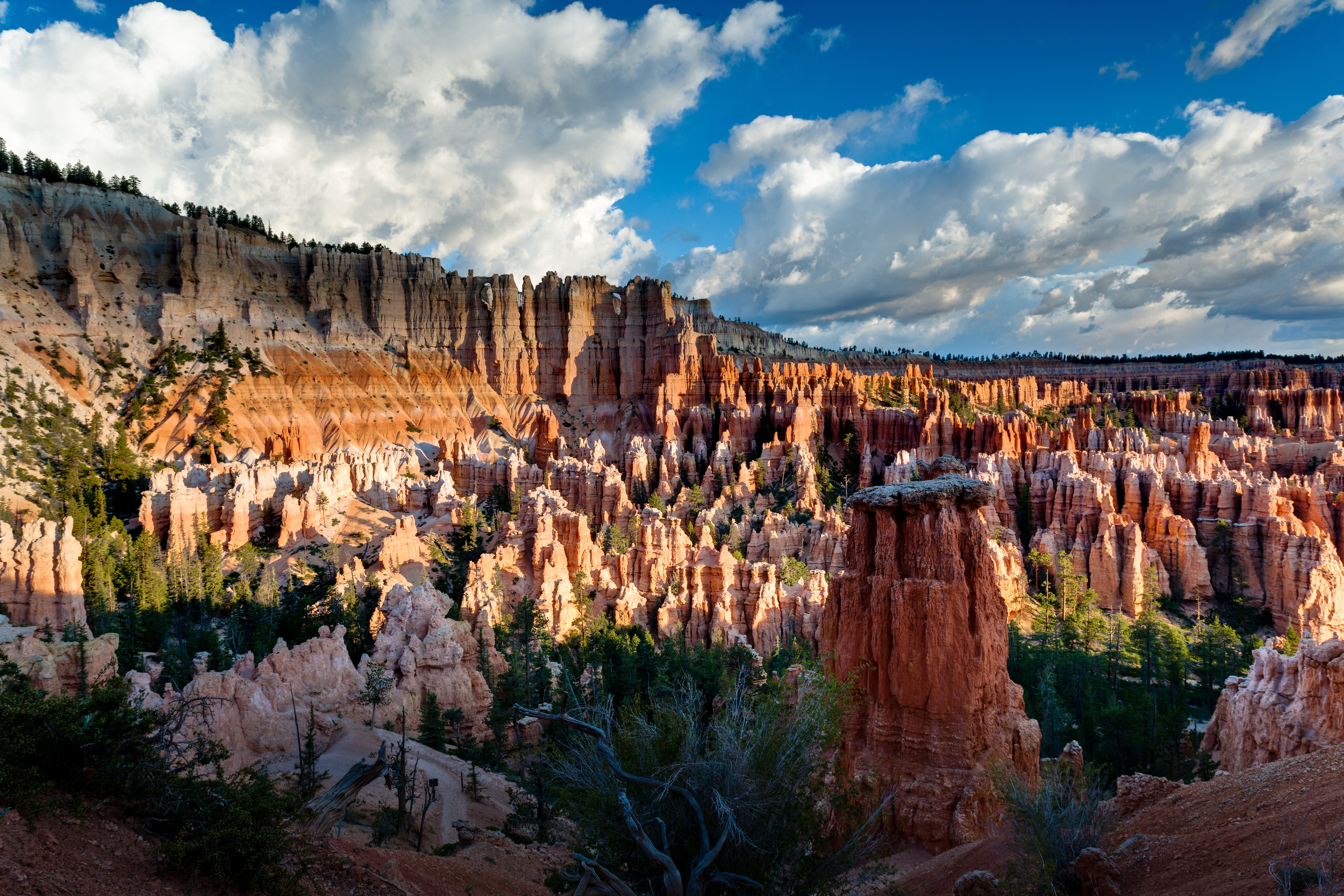
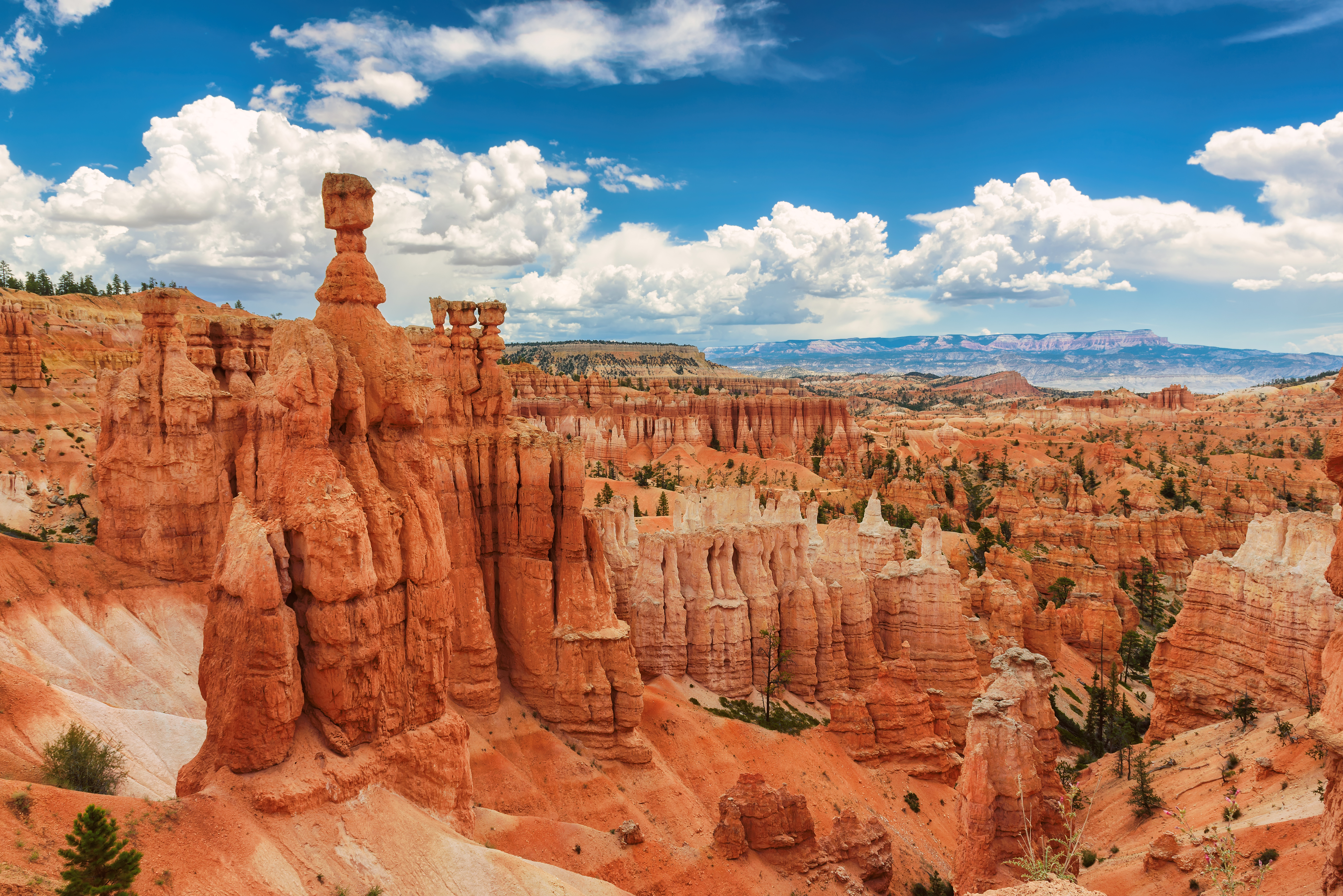
Bryce Canyon is not truly a canyon, but a series of bowl-shaped amphitheaters. For thousands of years, seasonal erosion created gullies in the edge of the Paunsaugunt Plateau, while rain, ice, and snow carved and sculpted the landscape into this extraordinary maze of hoodoos. The Bryce Amphitheater, before you, is constantly changing, chiseled by drainages that gather into Bryce Creek. The breathtaking views can extend nearly 100 miles (161 km) along the eastern horizon.
A panel at Inspiration Point overlook reads: The Amphitheater and Beyond Bryce Canyon is not truly a canyon, but a series of bowl-shaped amphitheaters. For thousands of years, seasonal erosion created gullies in the edge of the Paunsaugunt Plateau, while rain, ice, and snow carved and sculpted the landscape into this extraordinary maze of hoodoos. The Bryce Amphitheater, before you, is constantly changing, chiseled by drainages that gather into Bryce Creek. The breathtaking views can extend nearly 100 miles (161 km) along the eastern horizon. The viewpoint at Inspiration Point consists of three overlooks that provide varied perspectives of the main amphitheater, which is an expansive bowl-like feature carved into the edge of this high plateau. The canyon is filled with thousands of irregularly eroded spires of rocks called hoodoos, each pinnacle and its surrounding cliff faces are layered with jagged striations of orange, white, gray and brown stone fading to soft rolling forested hills in the distant valley. From here, visitors look toward the north to Sunset Point with its many rows of hoodoos and Sunrise Point set against the backdrop of Boat Mesa. A panoramic photograph spans the panel with labels of the key landscape formations that can be seen from this overlook. In the far distance from left to right: Sevier Plateau (13 miles/21 km) Aquarius Plateau (25 miles/40 km) Table Cliff Plateau (15 miles/24 km) Powell Point (15 miles/24 km) Canaan Peak (20 miles/32.1 km) Kaiparowits Plateau (70 miles/112.6 km) Navajo Mountain (82 miles/131.9 km) Within the park and amphitheater from left to right: Silent City Sunset Point Sunrise Point Boat Mesa Sinking Ship Bristlecone Point Bryce Creek The Cathedral Bryce Point Wall of Windows
Bryce Canyon Natural History Association (BCNHA) is a 501(c)(3) non-profit organization and the official nonprofit partner of Bryce Canyon National Park and Dixie National Forest, operating retail shops and visitor centers within the park, and surrounding national forest lands. Since 1961, BCNHA has provided over nine million dollars in support.
Visitor Center 223 words The park entrance station and visitor center are near the north end of the park along the main road, within a large expanse of sagebrush meadow and directly surrounded by stands of ponderosa pine. The entrance station along the road has three one room small kiosk booths with windows on all four sides. Park entrance tickets and information are available upon entrance. The visitor center is a 3 story L shaped building on a concrete foundation. Its construction although newer, is similar to the rustic style of the other buildings within the park; a combination of studs-out wood appearance emphasizing the framing as a decorative pattern on the exterior of the building and large exterior stone pillars at each of the buildings corners. The sharply pitched gable roof is covered with green corrugated metal roofing. The outside walls are painted dark brown and contrast with the lighter colored stone facing. A low stone wall runs around the base of the building. There are nearby pedestrian trails, a shuttle bus stop and available parking in the front. At the entrance of the building there is an informational tactile touch table to illustrate the topography within the canyon landscape along with interpretive panels and orientation maps. The visitor center houses a museum with exhibits, a small theater, restrooms, water station, visitor information and a bookstore.
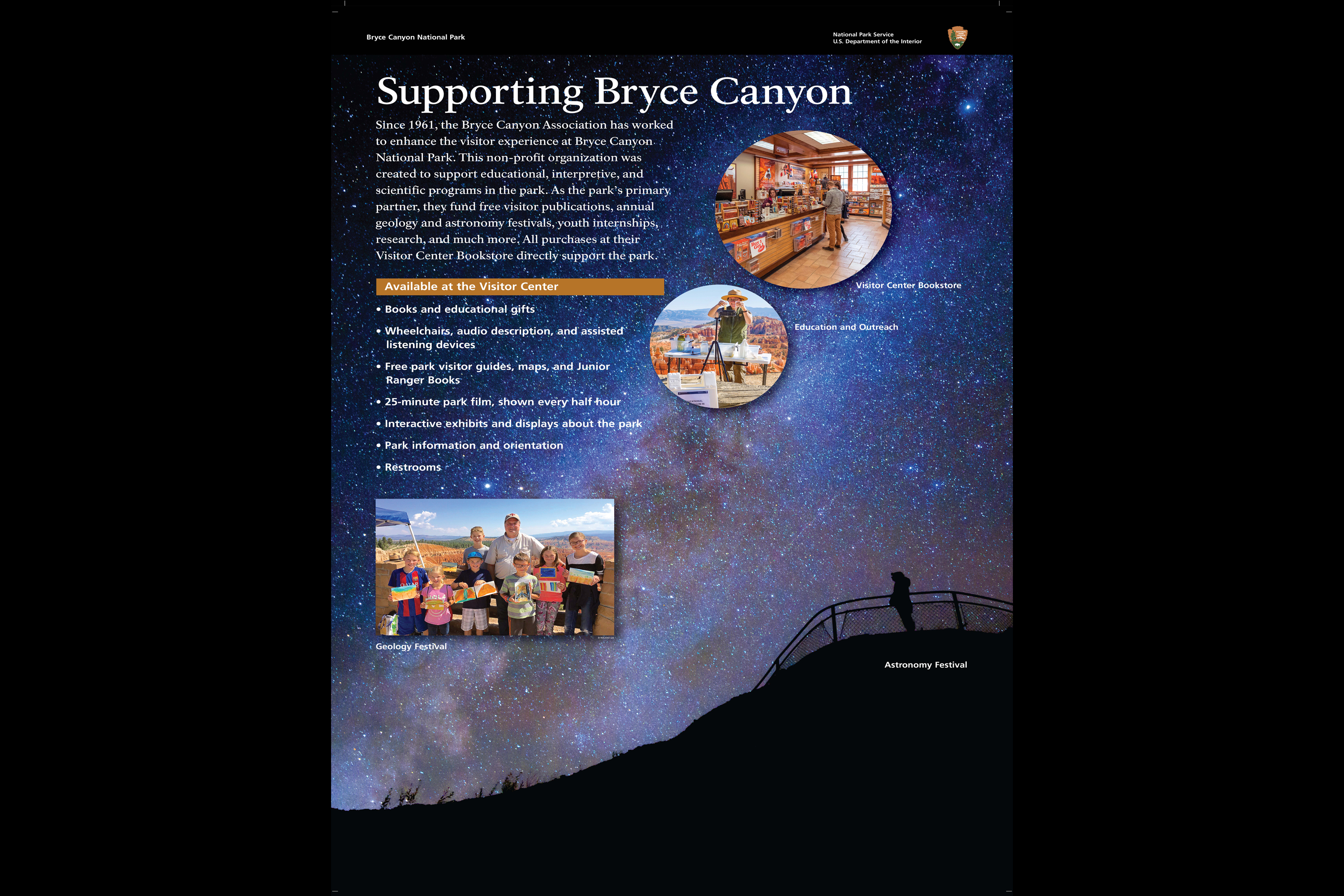
Since 1961, the Bryce Canyon Association has worked to enhance the visitor experience at Bryce Canyon National Park. This non-profit organization was created to support educational, interpretive, and scientific programs in the park. As the park’s primary partner, they fund free visitor publications, annual geology and astronomy festivals, youth internships, wildlife research, and much more. Your purchase directly supports the park.
SUPPORTING BRYCE CANYON A photograph of a person silhouetted against a stunning night sky streaked by the Milky Way provides the panel backdrop. Inset photographs illustrate some of the many ways volunteers support the park, through family festivals, education and outreach learning stations throughout the park and the Visitor Center Bookstore. Text explains: Since 1961, the Bryce Canyon Association has worked to enhance the visitor experience at Bryce Canyon National Park. This non-profit organization was created to support educational, interpretive, and scientific programs in the park. As the park’s primary partner, they fund free visitor publications, annual geology and astronomy festivals, youth internships, wildlife research, and much more. Your purchase directly supports the park. Services available at the visitor center ● Books and educational gifts ● Wheelchairs, audio description, and assisted listening devices ● Free park visitor guides, maps, and Junior Ranger Books ● 25-minute park film, shown every half hour ● Interactive exhibits and displays about the park ● Park information and orientation ● Restrooms
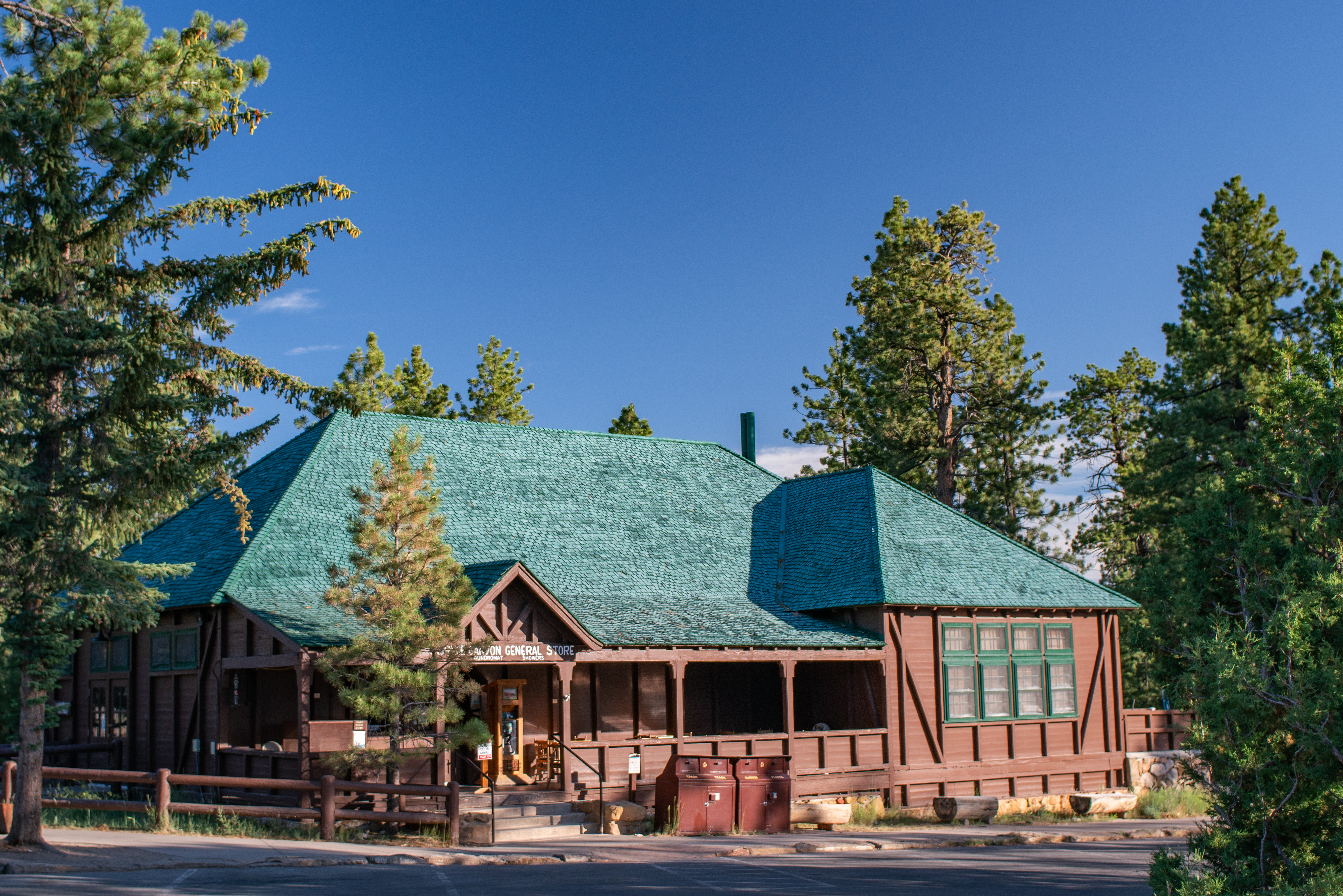
The General Store is located near Sunrise Point and North Campground. It serves "grab-and-go" hot and cold foods such as pizza, soup, ice cream, and sandwiches. Beverages such as soda, water, beer, and coffee are also available. Visitors can also find restrooms, showers, camping supplies including firewood, and souveniers. The General Store is typically closed between January and March.
General Store 123 words The General Store follows the same architecture as the lodge and cabins with an exposed frame, wood building painted dark brown, stone chimney and hip style roof where all roof sides slope downward at an angle. Green painted shingles cover the roof in a wavy pattern. The front of the building includes the camp store with a partially enclosed porch on the southeast supported by wooden posts and brackets. Stone steps, a sidewalk and brick entry welcome visitors. Framing the building is a rustic style log fence painted dark brown that wraps around to the side entrance of the building to the showers and restrooms. Within the fence grows ponderosa pine and grasses. Accessible parking is available, trash and recycling, laundry, provisions and snacks.
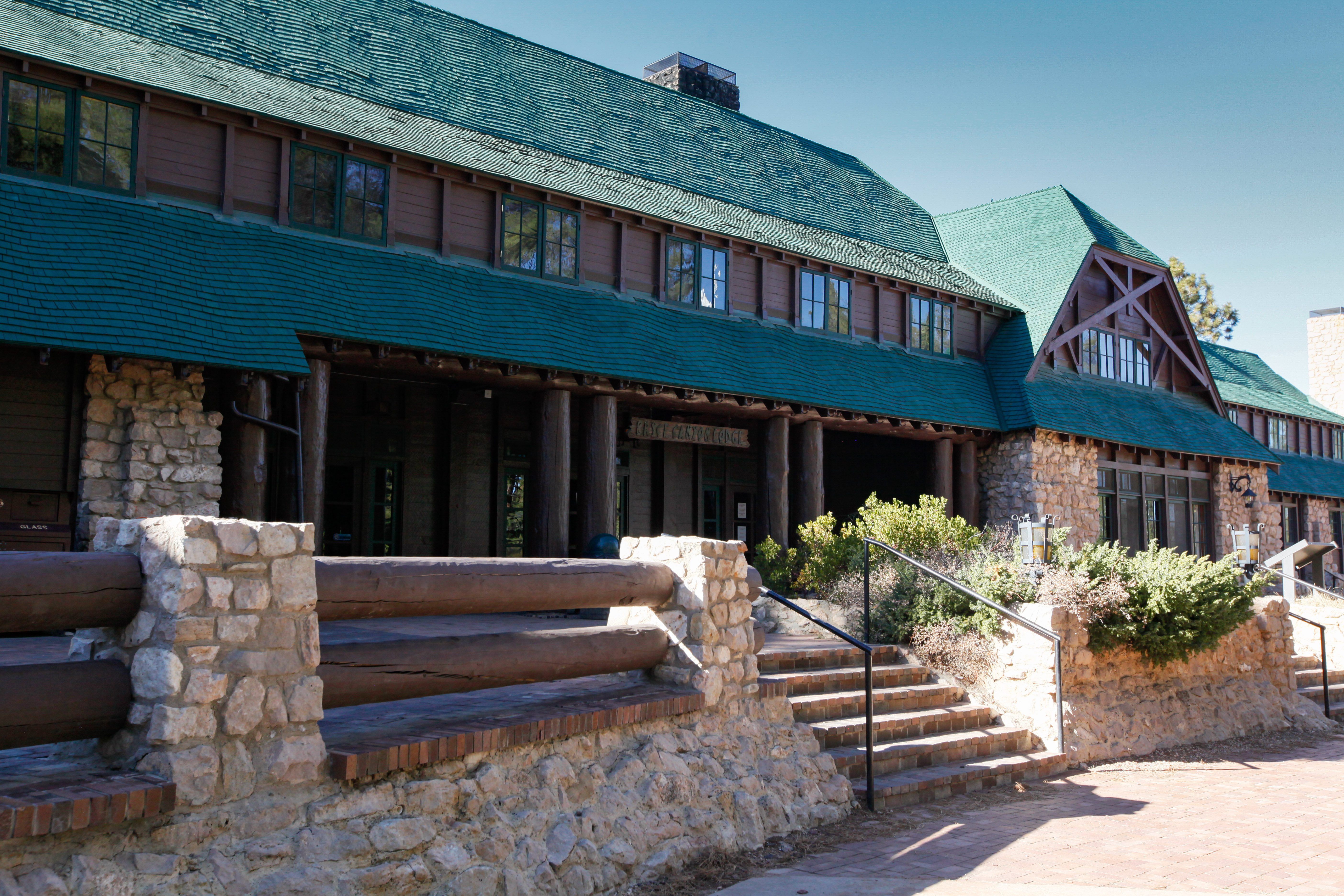
The Lodge at Bryce Canyon is one of the park's most iconic historic structures. The Lodge and its surrounding motel structures are located a short walk from the park's iconic Bryce Amphitheater, and offer 114 rooms including lodge suites, motel rooms, and cabins.
Bryce Canyon Lodge 263 words The lodge is located near the rim of the plateau between Sunrise and Sunset points set in a timbered knoll with native vegetation of Ponderosa Pines and low growing shrubs. Many smaller buildings are scattered around this main complex. All buildings in the area are an example of the rustic building design that blends well with the natural environment. The lodge: This two story building is irregularly shaped with a hipped roof structure. It is made of stone and exposed wood framing. The steeply pitched roofs are finished with wood shingles applied in a wavy pattern. Each corner of the building is anchored by sandstone pillars. Stone chimneys are located at various points and protrude above the roof line. The main entrance to the lodge features columns and log beam work along a long porch. Three centrally located staircases access the patio directly in front of the main entrance. Each step down to the road and connect with a trail that takes you to the Canyon rim. The patio is enclosed by a large diameter log railing set in stone piers that run the length of the front of the building. The patio is paved with red clay brick in a variety of patterns. The wood siding and exposed frame of the lodge are painted dark brown. The lodge and most other buildings in the area were designed in the rustic style using local stone and wood, with detailing to make the buildings look as if they had been constructed with primitive hand tools to ensure a natural look with the surrounding environment.
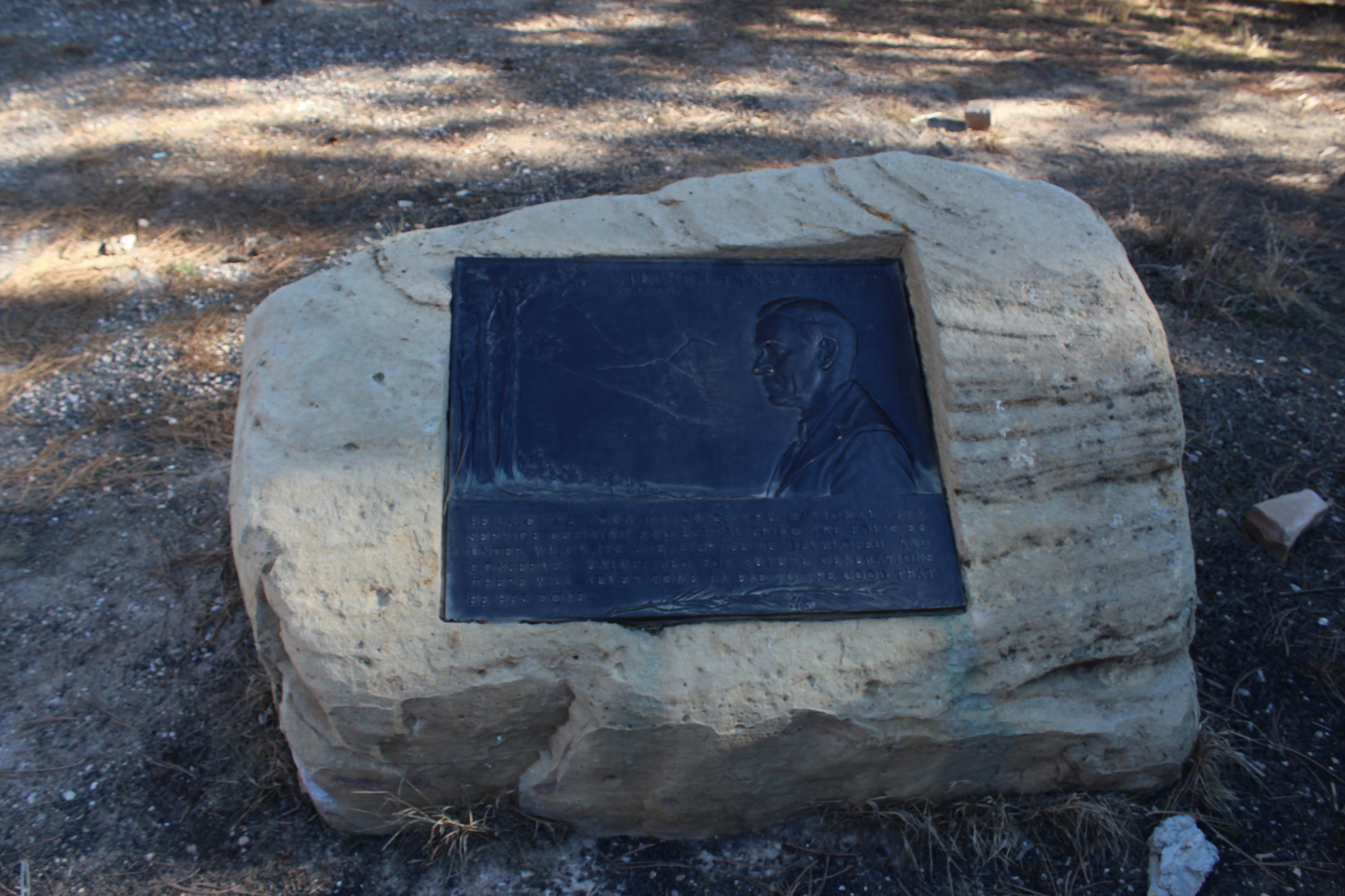
Embedded in a boulder beside the Visitor Center flagpole is a bronze plaque dedicated to Stephen Tyng Mather, known both as a successful businessman and avid conservationist whose vigorous efforts to build public and political support for the parks helped persuade Congress to create the National Park Service (NPS) in 1916.
Mather Plaque 90 words A bronze plaque is embedded into a stone on the ground near the entrance to the visitor center. The plaque is molded with the portrait of a man in the foreground and a landscape of mountains and trees behind. Text reads: Stephen Tyng Mather July 4th 1867- Jan 22 1930 He laid the foundation of the National Park Service defining and establishing the policies under which it's areas shall be developed and conserved unimpaired for future generations. There will never come an end to the good that he has done.
This stone monument marks the beginning of the park boundary.
A stone monument sign approximately 10 feet high by 30 feet wide made of stacked rock columns with a red rock center slab bears the words Bryce Canyon National Park United States Department of the Interior National Park Service. A National Park Service Arrowhead is mounted on the left stone column.
This path provides passage from Bryce Canyon city through Dixie National Forest into Bryce Canyon National Park. Hike, bike, walk or wheel all 5 miles to Inspiration Point, or stop at the shuttle stops and other amenities along the way.
Near the Bryce Canyon Shuttle Parking Area is the trailhead of a shared use path. A kiosk map shows that this paved trail takes you from Bryce City 5 miles into the park, past the visitor center, the general store, sunrise point overlook, the lodge, and sunset point overlooks and ends at inspiration point. Return trips use the same pathway. <br /><br />Three other Trailhead panels under roofed kiosks welcome visitors, describe rules and display a map of public lands and cities within the broader regions of Utah, Arizona, Nevada and New Mexico. <br /><br />Text reads: Welcome. This path provides passage from Bryce Canyon city through Dixie National Forest into Bryce Canyon National Park. Hike, bike, walk or wheel all 5 miles to inspiration point, or stop at the shuttle stops and other amenities along the way. <br /><br />Safety information follows:<br />Watch for wildlife maintain a safe distance. <br />Do not approach wild animals, do not feed the animals, help keep wild animals wild by properly discarding all food and food waste. Pets must be leashed, clean up after your pet. Stay hydrated, drink at least 1 quart of water every one to two hours, carry a water bottle. When thunder roars go indoors, thunderstorms create lightning and lightning can kill. Be a smart hiker, wear sturdy shoes, stay on the trail do not stray from designated trails. Help protect park resources it takes a long time for plants to grow and establish themselves. <br /><br />Next: Share the path <br />This is a shared use pathway for non-motorized transportation. Please be considerate and watch out for each other.<br /><br />Then rules for bicyclists: cyclists pass on the left and announced presents when passing. Be careful of your speed especially on downgrades and curves bicyclists are allowed on this path and other paved surfaces within Bryce Canyon National Park use extreme caution on roadways shared with motorized vehicles within the park. Bicycles are not allowed on unpaved surfaces. Please park your bike and walked to scenic viewpoints near the path.<br /><br />No horses on the path, no motorized vehicles on the path except for mobility purposes and pets must be leashed.
The shuttle station is the hub for the free Bryce Amphitheater shuttle. You can purchase your park admission at a window near the bus boarding area.
Bryce City (2 panels) 126 words An enclosed pavilion and shuttle station at the Bryce Canyon Shuttle Parking area in Bryce City provides information and an overview of things to do and see in the city and in the park. A map of the city shows locations for shuttle stops, restaurants, gas stations and places to stay. Panels along the interior walls illustrate experiences available in the Bryce Canyon Area. Text reads: Bryce canyon is a picturesque landscape with wonderful recreation opportunities. Color photographs show people on snowshoes, hiking and horseback riding, attending a ranger program and observing wildlife. Posters encourage you to stay longer by taking part in the following activities: tour the length of the park, sleep under the stars at a campground, hike or ride horseback on longer trails.
Look up! The same sunlight sustaining life all around you is also powering the visitor center. With its dry climate, high elevation, and mild average temperatures, Bryce Canyon’s Visitor Center checks all the boxes, making it an exceptional place to take advantage of solar energy. The solar array was funded by a Department of Energy grant and installed in 2015.
In front of you is an exhibit about the solar array that contributes power to local power grid and to the visitor center. To the left of this location are two massive solar panels. To the right is a parking area and the building where the visitor center is located. The exhibit is located near a path that passes closely by the solar panels. The exhibit is divided into two parts. To the left is an illustration that fills roughly two thirds of the exhibit. The illustration features a birds eye view of the very location at which you are standing. The right third of the exhibit a rich blue surrounds a brightly colored map of the united states and a chart showing the number of sunny days at Bryce Canyon over the course of a year. The illustration shows the landscape extending far off into the distance where a line of mountains are shown as a blue along the top. Above the row of mountains, in upper left, a bright yellow circle appears to be glowing with heat and light. This is the sun. The sun’s rays are shining directly down on two large solar panels. The solar panels are a deep blue with fine white lines forming a grid pattern. This represents the photovoltaic cells. Behind the solar array a row of poles supporting the power line that emerges from the ground continues to the left off the edge of the exhibit. In the foreground (the area of the illustration closest to you) is a warm colored landscape speckled with green trees. The trees get smaller as they descend into the distance. The illustration shows the two parking areas and a brown building with a multiple blue roofs and dormers. This is where the visitor center is housed. Between the solar array and the visitor center building we see a parking lot with a handful of cars. There is a trail that leads through the lot in the foreground, between the solar array and the visitor center, then veers off to the right before it vanishes between the trees. On the right of the building is the highway leading off into the distance. On top of the illustration, white lines with arrows and small gray boxes created a diagram to show the flow of the energy produced from the solar array. The energy begins with the sun rays hitting the solar panels. From the solar panels, the power goes to a series of transformers (represented as boxes in the illustration). From the transformer the power goes to the electrical lines and into the local power grid and to the visitor center. There is a black “you are here” marker indicating where this sign is located. At the base of the exhibit is a gray box with text explaining the steps of sunlight being captured and converted to solar power. The text on this wayside reads: Soak Up the Sun Look up! The same sunlight sustaining life all around you is also powering the visitor center. With its dry climate, high elevation, and mild average temperatures, Bryce Canyon’s Visitor Center checks all the boxes, making it an exceptional place to take advantage of solar energy. The solar array was funded by a Department of Energy grant and installed in 2015. On the top right side of the exhibit is a small blue box with text that reads: You Can Help! Reduce your carbon footprint by riding the free park shuttle from the visitor center, or enjoy the beautiful vistas as you walk or bike along the Shared-Use Path. In the foreground of the illustration is a grey box with text explaining the steps of sunlight being captured and converted to solar power. The text in this box reads: 1 Solar Panels Capture Sunlight This solar array’s panels intercept sunlight, which activates thousands of photovoltaic cells, creating electrical current. 2 Underground Cables Carry Current The electricity from all the cells flows down through cables beneath your feet to the inverters and transformer. 3 Supplying More Than Enough On a sunny day, the array generates 100-120 kWh solar power. That’s enough to power the visitor center, and then some. 4 Excess Power Goes to the Grid By contributing excess solar power to the local utility grid, the park receives a lower utility rate, saving taxpayer dollars. On the right side of the exhibit is a blue side bar featuring text and a map of the continental United States, with a bar graph below the map. The text reads: High and Dry Bryce Canyon’s dry air, high elevation, and lower latitude all increase the intensity of the sunlight it receives. Peak sun hours are a measure of how many hours of daily sunlight are capable of producing 1,000 watts of power per square meter. With 5.5 peak sun hours, Bryce Canyon exceeds national averages. Be sure to wear a hat and sunscreen! The top illustration of the continental United States delineates the different states with a simple black border. The map is shaded from light yellow in the top northern part of the country, to orange increasingly saturated along the central states, and to a deep red in the south western corner. A “you are here” marker points to the Bryce canyon location. Below the map the text reads: About half the days of the year are sunny at Bryce Canyon, and power production still occurs on many partly cloudy days. You are presented with a bar graph depicting weather patterns across the span of twelve months. Horizontally, the x-axis is divided into the months of the year, starting from January on the left and ending with December on the right. Vertically, the y-axis measures the number of days, marked in increments of 5 days from 0 days at the bottom to 30 days at the top, reflecting the length of an average month. Each bar representing a month is divided into three distinct colors. At the bottom of each bar, lavender segments indicate overcast days, characterized by more than 80% cloud coverage. Light green segments above the lavender denote partly cloudy days, with cloud coverage ranging from 20% to 80%. The top portion of each bar is colored yellow, representing sunny days with less than 20% cloud coverage. Across the graph, a jagged thin blue line zigzags, indicating days with precipitation. This visualization provides a comprehensive overview of the weather conditions throughout the year, highlighting the distribution of overcast, partly cloudy, and sunny days, as well as the occurrence of precipitation. The graph provides a detailed breakdown of weather patterns for each month of the year. In January, there were 6 overcast days, 11.5 partly cloudy days, 12.5 sunny days, and 6-7 days of precipitation. February saw 5 overcast days, 13 partly cloudy days, 10 sunny days, and 7-8 days of precipitation. Moving to March, there were 4 overcast days, 14 partly cloudy days, 12 sunny days, and 8 days of precipitation. As the months progress, the data fluctuates. For example, April experienced 3.5 overcast days, 14 partly cloudy days, 12.5 sunny days, and 8-9 days of precipitation. May showed 2 overcast days, 13 partly cloudy days, 12 sunny days, and 8-10 days of precipitation. June had 1.5 overcast days, 8.5 partly cloudy days, 20 sunny days, and 7-10 days of precipitation. In July, there were 2.5 overcast days, 16.5 partly cloudy days, 11 sunny days, and 11-15 days of precipitation. August experienced 2.5 overcast days, 15 partly cloudy days, 12.5 sunny days, and 12-14 days of precipitation. September had 2 overcast days, 10 partly cloudy days, 18 sunny days, and 7-11 days of precipitation. Moving into the later months, October saw 3.5 overcast days, 10 partly cloudy days, 16.5 sunny days, and 5-7 days of precipitation. November experienced 4 overcast days, 10 partly cloudy days, 16 sunny days, and 5-6 days of precipitation. Finally, December had 6 overcast days, 13 partly cloudy days, 11 sunny days, and 6-7 days of precipitation. This detailed breakdown offers insight into the varying weather conditions throughout the year, including the frequency of overcast, partly cloudy, and sunny days, as well as the occurrence of precipitation. We can conclude that June has the most sunny and least amount of overcast days. The least amount of sunny days are in February. July and August have the most precipitation.
Canyons are formed by rivers, but the colorful scene before you wasn't created by one. Bryce "Canyon" is, instead, a series of bowl-shaped drainages called "amphitheaters" that only contain water when rain or snow fall into them. As this water drains east joining the Paria River, the plateau rim erodes away with it. This process causes the park's many amphitheaters to enlarge at a rate of one to four feet every century.
Bryce Canyon? Three diagrams illustrate the layered stone landscape of Bryce Canyon. What begins as a smooth and featureless landscape beginning about 20 million years ago becomes, over time and weathering, the eroded and rugged Bryce Canyon of present day. Captions explain: First tectonic forces fractured, displaced, and lifted this area. This uplift created the Paunsaugunt Fault, defining the eastern edge of the Paunsaugunt Plateau. Then greater erosion occurs to the west of the fault line six million years ago, the Paria River began flowing and eroding the valley to the east. Seasonal drainages that feed the Paria River began to shape both sides of the valley and amphitheaters began to form. The last diagram shows a now deeply eroded canyon-like landscape: Erosion by the Paria River began in the south, where it joins the Colorado River, and is still moving slowly north. Northern amphitheaters, like this one, are smaller and less deep than those further south in the park. Text continues: Canyons are formed by rivers, but the colorful scene before you wasn't created by one. Bryce "Canyon" is, instead, a series of bowl-shaped drainages called "amphitheaters" that only contain water when rain or snow fall into them. As this water drains east joining the Paria River, the plateau rim erodes away with it. This process causes the park's many amphitheaters to enlarge at a rate of one to four feet every century.
Here at Bryce, the elevation ranges from 9,100 feet (2,778 m) at Rainbow Point to 6,600 feet (2,012 m) at the canyon bottoms. The accompanying wide range of temperatures and precipitation creates three distinctive climatic or life zones—Mixed Conifer (highest elevation), Ponderosa Pine (mid-elevation), and Pinyon/Juniper (lowest elevation).
A three-dimensional topographic image of the park shows our location here in the mixed conifer life zone at Rainbow Point, This is the highest elevation of 9,100 ft at the southern end of the park. To our north the Ponderosa Pine life zone at 8,000 ft and then the Pinyon Juniper Life zone at 6,600 ft are labeled. Title and introductory text reads: Bryce Life Zones Here at Bryce, the elevation ranges from 9,100 feet (2,778 m) at Rainbow Point to 6,600 feet (2,012 m) at the canyon bottoms. The accompanying wide range of temperatures and precipitation creates three distinctive climatic or life zones—Mixed Conifer (highest elevation), Ponderosa Pine (mid-elevation), and Pinyon/Juniper (lowest elevation). This diversity of habitat creates incredible opportunities; here you can find over 100 species of birds, dozens of mammals, and more than a thousand plant species. Description of the three life zones continues from left to right beginning with the Pinyon Juniper Forest at the lowest elevation. Pinyon/Juniper Forest A background photograph shows a cluster of shrubs and trees that illustrate the diversity of species found in this life zone: Juniper, Ponderosa pine, Greenleaf manzanita, gambel oak, the buff-colored cones, and nuts of the Pinyon Pine and the spikey narrowleaf yucca. Animals are featured that include a small squirrel like Uinta chipmunk, Greater short-horned lizard and a blue Pinyon Jay perched on a branch. Text continues: The pinyon/juniper community, found at lower elevations, is defined by pinyon pine and juniper. Look for short evergreen trees and a variety of desert and upland shrubs. Springs and irrigation water found here create refuges for more water-dependent plants. Experience this life zone along the Mossy Cave Trail. Next the Ponderosa Pine life zone at the middle elevation: A background photograph shows a Ponderosa Pine forest with lower growing Greenleaf manzanita shrubs in the understory. A close-up of the pine bark is emphasized with a caption that reads: The thick, plated bark of ponderosa pine is an adaptation that protects the tree from fire. A series of photographs feature other plants and animals found here to include the delicate bunching Indian rice grass, the small blue berries of the Oregon grape and the soft yellow flowers of the Antelope bitterbush. A gold-mantled ground squirrel eats a nut on a rock, a mule deer grazes in a meadow and a bird, the Pygmy nuthatch with a white underbelly, straight sharp bill and slate gray back sits on a branch. Text continues: Ponderosa pine forests define this community. These stately evergreens can grow 200 feet tall (61 m) and often live up to 500 years. Ponderosa pines have adapted to depend upon low-intensity fires, typically started by lightning. Fire maintains an open forest floor, clearing dense growth, so that grasses, wildflowers, and new trees can flourish. Fire's rejuvenating effect on this ecosystem attracts and supports diverse wildlife. Last the Mixed Conifer life zone here at our location. A background photograph shows an example of a dense mixed conifer forest of varying tree species to include the tall and erect Engelmann spruce with its short green needles and reddish elongated cones and deciduous quaking aspen in the foreground. A series of photographs feature other plants and animals found here to include a mountain lion crouched on a rock, the purple cluster of blossoms of the Lupine flower, an elk standing in a meadow and the Clark’s nutcracker; a grey bird with black wings and thick pointed bill. Text continues: Mixed Conifer This life community, found at the highest elevations of the park, contains a mixture of conifer (cone-bearing) trees, including white fir, Douglas-fir, Engelmann spruce, bristlecone, and limber pines. Plants here provide important habitat for many species, such as woodpeckers, owls, squirrels, and elk. Text reminds us not to feed or approach wildlife, for our safety and theirs.
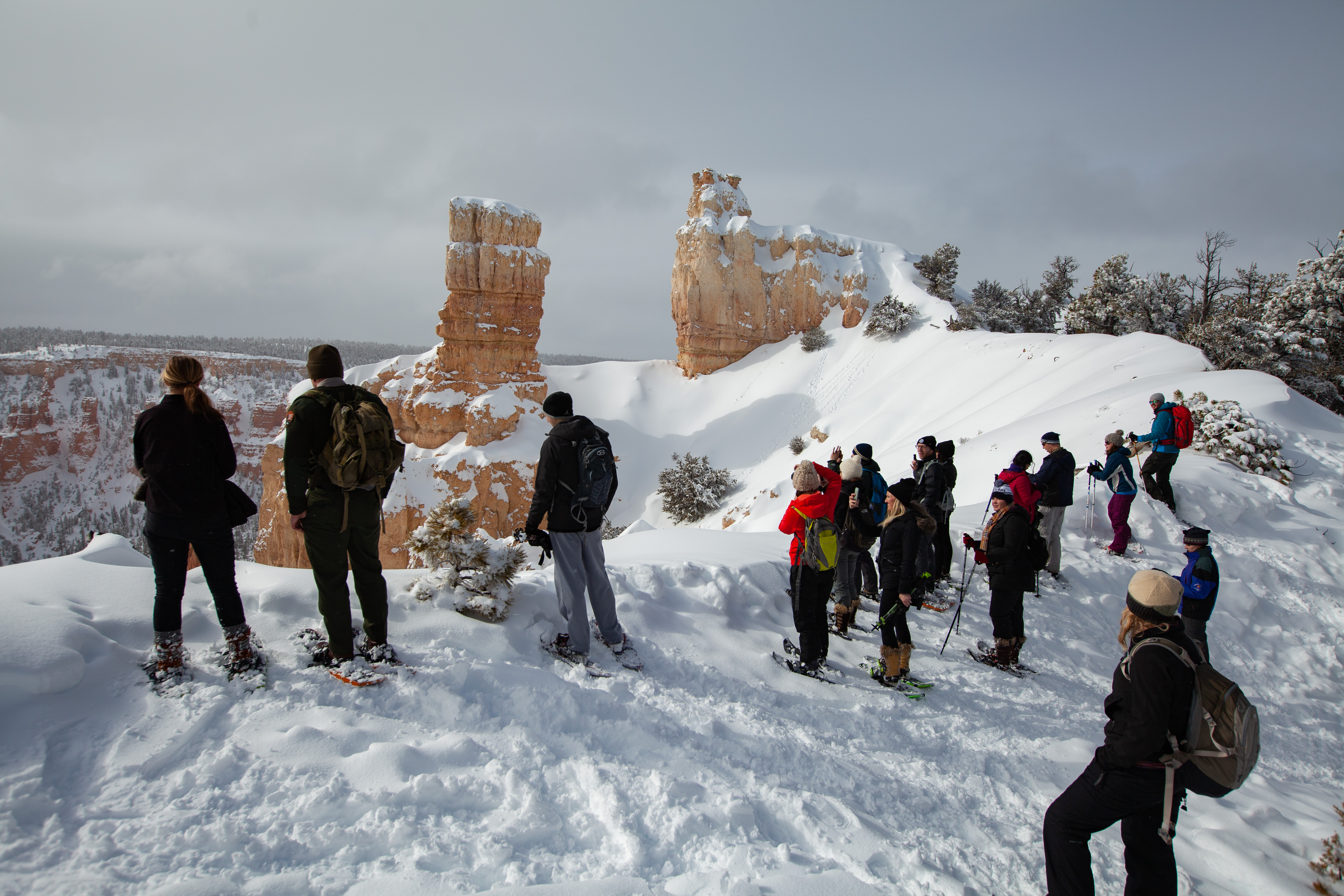
Perhaps the most iconic of all the Bryce Amphitheater's four major viewpoints, Bryce Point provides a soaring view of the park's most popular area. The view and the park share the same namesake, Ebenezer Bryce, who settled in the Paria Valley in 1870. Bryce was a shipbuilder who journeyed west with Brigham Young and the Mormon pioneers to assist in the construction of buildings essential to community life throughout the new land. Bryce lived here for only five years, but in t
A brown wooden sign at this location reads Bryce Point Elevation 8300 feet. A path runs adjacent to the plateaus edge and is enclosed with a horizontal log railing with stone columns. From Bryce Point is one of the most scenic vistas of the main Bryce amphitheater. Visitors stand on a narrow fin of rock facing out into the amphitheater, which is an expansive bowl-like feature carved into the edge of the high plateau. The canyon is filled with thousands of irregularly eroded spires of rocks called hoodoos. Each spire and cliff face continues layered striations of orange, white, gray and brown fading to soft rolling hills of forest in the distant valley.
Starting in the 1920s, the Union Pacific Railroad and their subsidiary, the Utah Parks Company, played a key role in the development and popularization of Bryce Canyon and many other western national parks. They provided first-class train and bus transportation, lodging, and tours. Between 1923 and 1929 they built the Bryce Canyon Lodge, along with 15 deluxe and 67 standard cabins in the National Park Service rustic style.
The panel is on the bike path near a cluster of cabins to interpret the history of this area as a tourist destination. A black and white photograph of one of the deluxe cabins built for early visitors fills the scene. This impressive one-story rectangular building is constructed on a stone foundation with a rubble masonry chimney. The steeply pitched gable roofs are finished with cedar shingles set in a wavy pattern like those of the main lodge and are painted green. Log slab siding runs horizontally on the main walls and vertically on the ends, the logs are separated from each other by a chinking of cement. The north and south entrances of each cabin have 2 panel wood doors. At the front of each unit is a rustic porch with log framework and log railings. Text Reads: Building Bryce and Beyond Starting in the 1920s, the Union Pacific Railroad and their subsidiary, the Utah Parks Company, played a key role in the development and popularization of Bryce Canyon and many other western national parks. They provided first-class train and bus transportation, lodging, and tours. Between 1923 and 1929 they built the Bryce Canyon Lodge, along with 15 deluxe and 67 standard cabins in the National Park Service rustic style. In 1987, the lodge and deluxe cabin area became a historic district and a National Historic Landmark. An inset black and white photograph of the tiny, more rustic economy cabins provides a comparison in accommodations. Caption reads: Standard and economy cabins, with two single beds, offered more affordable, rustic accommodations. All, but six near the lodge, were removed by 1989.
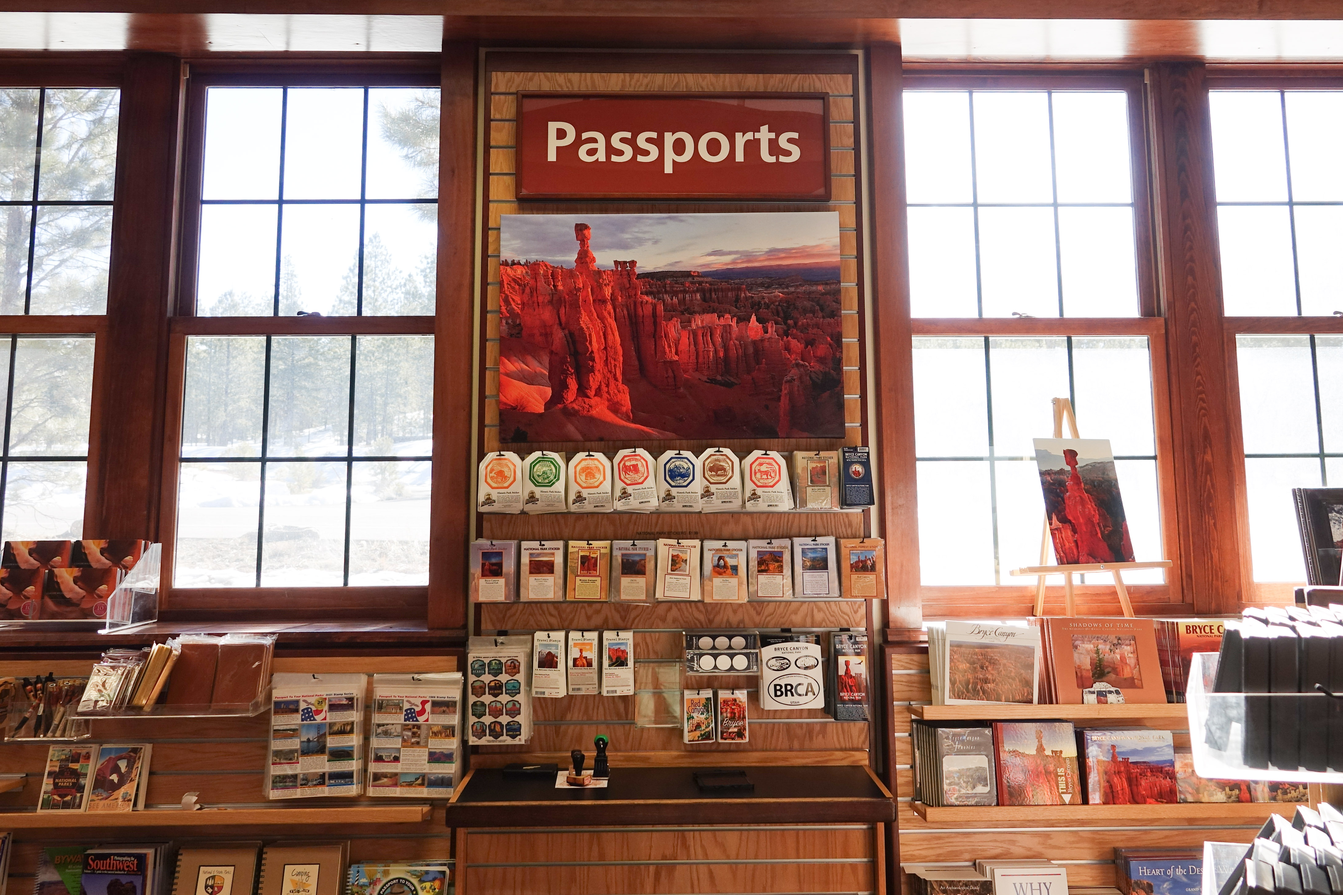
No reservations are required to enter Bryce Canyon, but whether you arrive by car, shuttle bus, bicycle, or on foot, park entrance fees will apply. These park entrance fees help support improvement projects and staff to improve your visitor experience. Digital Passes provide a flexible way to pay your entrance fee, support Bryce Canyon, and get you into the park faster.
Picnic tables are available for use at this forested pull-out at Mile 5 of the main park road.
Picnic tables are arranged in a forested area along multiple packed sediment paths. This area is reached from a parking pullout along the main park road. Beyond the forested area are open grassy meadows of East Creek.
The park's General Store, designed by Gilbert Stanley Underwood, was the Utah Parks Company's last major improvement in the National Park Service rustic style. Built in 1932, it was known as Bryce Inn and served as the nucleus of more than 25 concessions buildings and cabins known as Camp Center.
This panel near the General Store interprets historic uses of this area of the park. A black and white photograph taken in 1938 shows staff smiling as they sit along the front porch steps of the Camp Center building, one man wears a tall white chef’s hat. A sign above them reads: Camp Center: cafeteria, store, cabins. Text Continues: Camp Center The park's General Store, designed by Gilbert Stanley Underwood, was the Utah Parks Company's last major improvement in the National Park Service rustic style. Built in 1932, it was known as Bryce Inn and served as the nucleus of more than 25 concessions buildings and cabins known as Camp Center. Bryce Inn originally provided a cafeteria, and later a camp store, showers, and laundry. Directly to the south, the park's first administrative building was also built in 1932. It provided an early Park Service presence and a station for the park's first ranger, Maurice Cope. Today it provides educational opportunities as the High Plateaus Institute. A smaller inset photograph taken in 1938 shows a row of standard cabins, simple square, brown single-story structures. Caption reads: By 1989 the cabins and concessions buildings were removed. Six standard cabins from this era can still be found by the lodge.
The colorful Claron Formation was formed 50 to 60 million years ago in a system of lakes that stretched across central Utah. Separated into an upper white member and lower pink member, both are composed primarily of limestone mixed with varying amounts of silt and clay. Intermittent layers of mudstone and sandstone were deposited as the lake levels rose or fell and rivers flowed across the basin.
A panel here at the Sunset Point Overlook explains the geology of deposition and uplift of the types of colored rock layers that formed Bryce Canyon. A full color photograph of the view from Sunset Point fills the panel. In the distance to the left, Bryce Point is labeled as is Inspiration Point to the right. Title and text reads: Deciphering Nature’s Palette The colorful Claron Formation was formed 50 to 60 million years ago in a system of lakes that stretched across central Utah. Separated into an upper white member and lower pink member, both are composed primarily of limestone mixed with varying amounts of silt and clay. Intermittent layers of mudstone and sandstone were deposited as the lake levels rose or fell and rivers flowed across the basin. Around 20 million years ago, this region was shifted by tectonic forces, lifting it from sea level to its present-day elevations. Exposed before you at 8,000 feet (2,438 m), the fragile pink cliffs of the Claron Formation are sculpted by ice and rain into rock spires called "hoodoos." Further text is overlayed on the photograph at specific locations to demonstrate the different rock types and formations. From left to right: First The conglomerate at Bryce Point, 50–100 feet thick, is the youngest rock layer seen in the park atop Boat Mesa and Bryce and Inspiration points. Around 30 million years ago, rivers created this layer of pebbles enclosed by smaller sand grains. Then Dolomitic limestone layers, reinforced with magnesium, look like concrete, and are highly resistant to erosion. These “caprocks” are essential to hoodoo formation, as they protect the softer layers underneath them. Next in the center of the image The lower pink member, a mixture of limestone, mudstone, silt, clay, and sandstone 500-700 feet thick, was deposited as lake levels repeatedly rose and fell. Iron and manganese combine with oxygen to create the distinctive colors. Almost all of the park’s hoodoos are formed in this member. Then The Claron’s white member, around 300 feet thick here, formed when this was a deep lake. This purer limestone erodes forming sheer cliffs and grottos best seen near Bryce Point. North of Sunset Point it has completely eroded away. And last at the far right along the canyon rim The pink member’s softer rocks, like mudstones, erode more quickly and deeply than more resistant layers, creating indentations that can be traced horizontally.
The Rim Trail This is the northern end of the 5.5 mile (8.9 km) Rim Trail that begins in the south at Bryce Point. Fairyland Loop The Fairyland Loop is a strenuous 8 mile (12.9 km) loop.
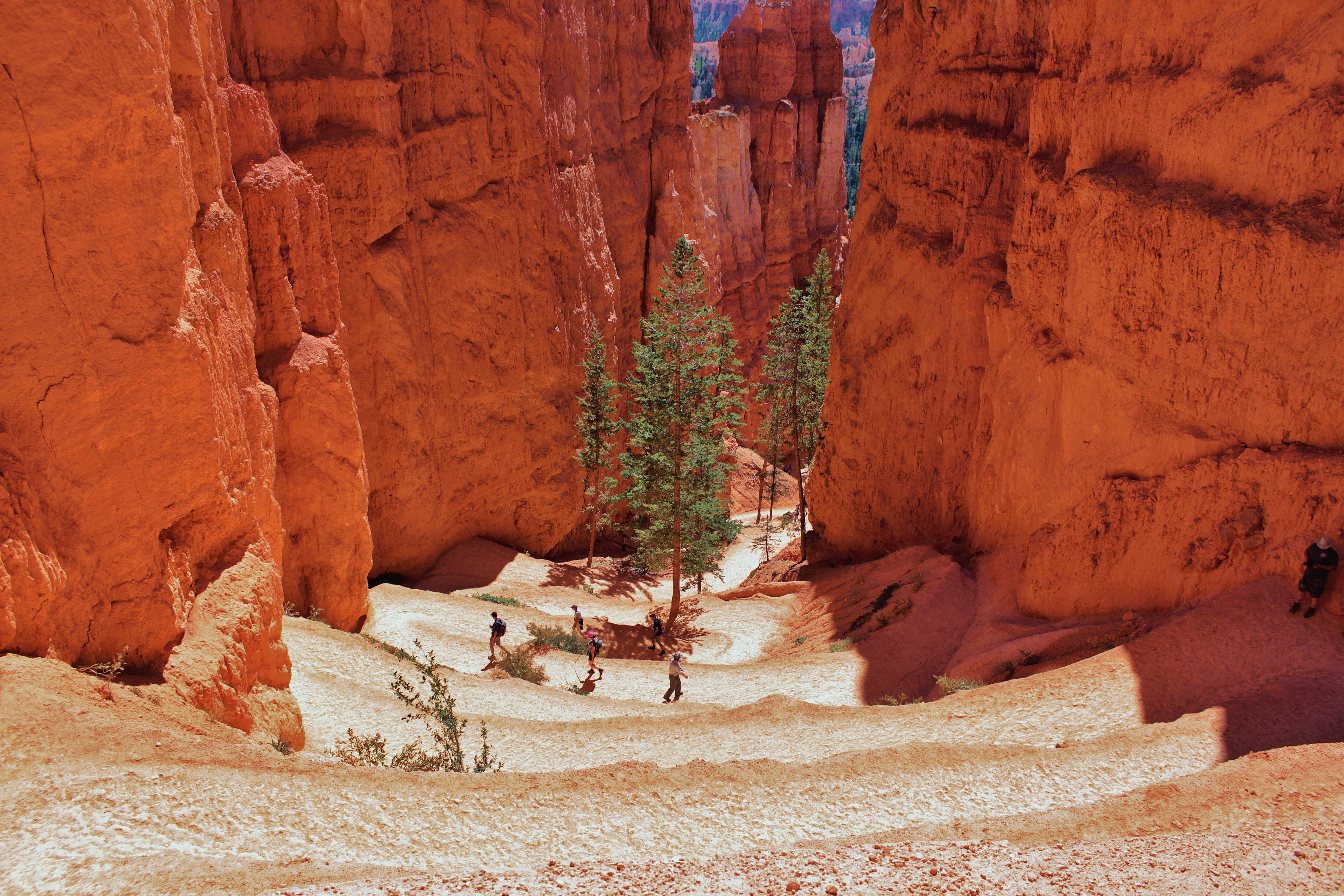
A winding compacted sediment trail descends along a bowl-shaped erosional feature filled with red, orange, and white rock spires.
Follow this trail and discover nature’s fairyland of rock castles, cliffs, and spires. It begins with spectacular views from the rim, then continues down into the amphitheater, past fragile, towering hoodoos and cathedral walls. Changes in light create a mesmerizing, colorful palette at every turn. Look for the spur trail to Tower Bridge. Some of the named features along this loop are Boat Mesa, Sinking Ship, and Chinese Wall.
Fairyland Loop Orientation Two upright panels are here near the parking lot; the first is the orientation to Bryce Canyon with full park map. The second provides details about our location here at the Fairyland Loop trailhead. A map illustrates that we are at the northernmost park overlook and a graphic provides details about the trail: Length: 8 miles (12.6 km) Difficulty: Strenuous Total Ascent: 1,900 feet (579 m) A panel just down the path at the Fairyland Point viewing area explains why this is really not a canyon but a series of thirteen amphitheaters along the edge of a high plateau. A photograph along the bottom of the panel shows a view from the Fairyland Loop trail. Two inset photographs demonstrate things to do near here: take the spur trail to the tower bridge formation and discover Boat Mesa, a large flat-topped feature topped with a creamy colored conglomerate. A bronze coin-shaped medallion on the panel signals that One “Hike the Hoodoos” medallion is found along this trail. Find it, then take a photo or rubbing. When you’ve found three different medallions or hiked 3 miles (4.8 km) on trails that have benchmarks (see Visitor Guide) take them to the visitor center for a reward. Text continues: Follow this trail and discover nature’s fairyland of rock castles, cliffs, and spires. It begins with spectacular views from the rim, then continues down into the amphitheater, past fragile, towering hoodoos and cathedral walls. Changes in light create a mesmerizing, colorful palette at every turn. Look for the spur trail to Tower Bridge. Some of the named features along this loop are Boat Mesa, Sinking Ship, and Chinese Wall. What shapes can you see in these fanciful formations?
The shuttle does not provide service to Fairyland Point. Fairyland Point is the northernmost viewpoint along the rim of the Paunsagunt Plateau within the park. The hoodoos (irregularly eroded rock spires) that fill Fairyland Canyon are younger than those further to the south in the main Bryce Amphitheater.
A sign at this overlook reads Fairyland Canyon elevation 7758 feet.<br />Fairyland is located at the north end of the park, one mile north of the entrance station. This section of the park has the youngest rock formations with primarily ponderosa pine forest. A path runs adjacent to the canyon edge and is enclosed with a horizontal log railing with stone columns. A trail head sign marks Fairyland Trail and visitors are reminded to wear boots due to loose rocks and steep trails. Tower Bridge is 4 miles down the trail and Sunrise Point is 5.7 miles down Fairyland trail.<br /><br />A wayside panel at the overlook is titled: Retreating Cliffs.
From here the Rim Trail continues another 2.5 miles (4.0 km) north to Fairyland Point offering views of Boat Mesa and distant features beyond. At Fairyland Point hikers can descend below the rim to complete the strenuous 8.0-mile (12.9 km) Fairyland Loop hike. Those looking for a more moderate hike below the rim will enjoy the southern end of the loop, known as the Tower Bridge Trail. This 3.0-mile (2.4 km) out-and-back hike leads to the Tower
Background Image. The background image of this exhibit features a tall solid rough textured limestone rock wall with a blue sky above the wall. The wall has orange, gold, pink, and tan horizontal layers which blend and fade to a faint grey and light tan on the top. The wall has a rough bulbous texture and is fairly straight vertically and horizontally. The top of the rock formation varies in height and is jagged. The rock is limestone of inconsistent hardness and density. The text reads: Fairyland and Tower Bridge Trails. From here the Rim Trail continues another 2.5 miles (4.0 km) north to Fairyland Point offering views of Boat Mesa and distant features beyond. At Fairyland Point hikers can descend below the rim to complete the strenuous 8.0-mile (12.9 km) Fairyland Loop hike. Those looking for a more moderate hike below the rim will enjoy the southern end of the loop, known as the Tower Bridge Trail. This 3.0-mile (2.4 km) out-and-back hike leads to the Tower Bridge hoodoo and has a total ascent of 760 feet (232 m).Tower Bridge Hoodoo. The second image, a small circular image in the center of the exhibit, is a freestanding wall with large irregularly shaped holes in the wall. The blue sky appears through the holes. The hoodoos are uniquely beautiful sometimes described as spiracles, sandcastles, people, animals, or objects from myths and legends. The holes, also called windows, have been created by weathering and erosion over thousands of years. The strongest rock, generally at the top, is slower to erode which helps create the framework for the windows and supports the top of the wall. Hoodoos don’t grow like trees but are eroded out of the cliffs where rows of narrow walls form. These thin walls of rock are called fins. Frost-wedging enlarges cracks in the fins, creating holes or windows. As windows grow, their tops eventually collapse, leaving a column. Rain further dissolves and sculpts these limestone pillars into bulbous spires called hoodoos. The delicate climatic balance between snow and rain ensures that new hoodoos will emerge while others become reduced to lumps of clay. The windows have been formed by a process called frost wedging. Bryce Canyon is located on a high elevation plateau and winters are snowy and cold. Temperatures drop below freezing at night and as midday temperatures rise above freezing the ice and snow melts and trickles into the cracks. When the temperatures drop below freezing again at night and early mornings the ice expands and the pressure cracks and chisels the rocks. Because the rock wall is limestone the erosion rate is inconsistent throughout the wall creating interesting forms and shapes. The caption reads: Tower Bridge Hoodoo. There is a section that lists rules and regulations with icons. The text reads: Know Before You Go. There is no Shuttle service at Fairyland Point. Hikers must return to Sunrise Point for shuttle service. Leave No Trace: Stay on designated trails, leave what you find, and take what you bring. Climbing is not permitted in the park. Dehydration, altitude sickness, and ankle injuries are the most common emergencies. Drink 1 liter of water every 2 hours, know your limits, and wear proper footwear. If you hear thunder, lightning strikes are possible. Avoid trees, hoodoos, and other tall objects. Flash flooding is possible in dry washes during heavy rainstorms. Help protect wildlife. Do not approach or feed animals. Many wildlife deaths are caused by speeding vehicles. Pets are permitted on paved surfaces only. Keep pets on leash and clean up after them. Bicycles are allowed on paved surfaces only. They are not permitted on or below the rim. Drones are not permitted. Violators face legal action and fines. Report drone use to nearest park ranger. Below the rules and regulations section is a graph that shows the elevation levels of Fairyland Loop Trail. The text reads: Length: 8 mi (12.9 km) roundtrip Difficulty: Strenuous Total Ascent: 1900 feet (579 meters). The graph shows that the trail starting point at this location, Tower Bridge.Trailhead is just below 8000 feet in elevation. After about one mile the trail reaches its highest point with 8200 feet elevation. For the next 3 miles the elevation drops 1000 feet. At Fairyland Point the elevation is 7700 feet. After another 2 miles the trail drops to 7200 feet. For the next mile after this the elevation gains again to 7500 feet, followed by a slight decrease and increase to 7400 feet at mile 6. Following the trail for another half a mile to Tower Bridge Hoodoo will take us just below 7200 feet. To continue on to Tower Bridge trailhead there is a dramatic increase for the final stretch of 2 miles ending at 7900 feet. Below the graph is a section with icons giving information about the trail accessibility. The text reads: Typical Grade is 9.0% Maximum Grade is 25.0% Typical Cross Slope is 5% Maximum Cross Slope is 39% Typical tread width is 49 inches (124 cm) Minimum tread width is 16 inches (41 cm) The trail surface is firm native sediment. There is a large color map titled Bryce Amphitheater Area. This is a color map highlighting the main area of the park known as the Bryce Amphitheater. This map is a close up of the area focusing on the roads, trails, geologic features, and other amenities offered. The main road, State Route 63, extends along the left side of the map with the amphitheater area and most of the amenities to the right of it. In the lower left hand corner there is a map key and in the lower right hand corner there is a north arrow and scale bar to indicate distances. This is a detail map of the amphitheater area of the park. Its primary purpose is way finding. It is oriented with north at the top and covers an area of approximately eight square miles. Highway 63 is depicted as a red line running north south on the left side of the map through the national park plateau area. This portion of the map begins slightly north of the park entrance sign where it indicates the road will continue north to Bryce Canyon City and extends down until it curves to the bottom left edge of the map where it indicates the road will eventually lead to Rainbow Point. On the left edge and upper left corner of the map, a small area outlined by a green box indicates Dixie National Forest land.The Shared use path is indicated by a green dashed line and runs parallel to Highway 63, crossing the highway from west to east just north of Fairyland Point, continuing south to the Visitor Center parking area where it where it crosses east to west and continues south approximately 2 and three quarter miles to Inspiration Point. On the right side of the map there is a darker tan colored area that indicates the boundaries of the main amphitheater. Along the edge of this darker area is a dashed black line indicating the Rim Trail which curves from Fairyland Point at the top down to Bryce Point at the lower right. The portion between Inspiration Point and Bryce Point is closed during winter. A green dotted line extends from Sunrise point indicating a horse trail. It becomes a green dot and black dashed line at Peekaboo Trail where it becomes a horse and hiking trail. A black dashed line extends east from the Peekaboo connector trail indicating a trail that leads to the town of Tropic. Numerous trails and amenities are indicated on the map and are listed by location, moving from north to south: Fairyland Point overlook and parking area, located north of the Fee Stations and Visitor Center, mile marker quarter mile. Fairyland Loop Trailhead. Fee Stations, mile marker one, Visitor Center, mile marker one. Ranger Station, restrooms, drinking water, telephone, visitor center shuttle station, inbound and outbound. North Campground, mile marker one. Drinking water, campground, picnic area, outdoor theater, RV dump station summer only. General Store, mile marker one and a quarter. Parking area, showers, laundry, food, restrooms, drinking water, telephone. Sunrise Point, mile marker one and a quarter. Viewpoint and Queens Garden trailhead. Parking area, Sunrise Point shuttle station, outbound, horse corral. Bryce Canyon Lodge, mile marker one and a half. Restaurant, restrooms, drinking water, telephone, Bryce Canyon Lodge shuttle station, outbound. Sunset Point, mile marker two. Viewpoint and Navajo Loop Trail. Wall Street side of Navajo Loop Trail is closed in winter. Parking area, restrooms, drinking water, picnic area, Sunset Point shuttle station, outbound. Sunset Campground, mile marker two and a quarter: Viewpoint. Drinking water, camping, Sunset Campground shuttle stop, inbound and outbound. Inspiration Point, turn off at mile marker two and three quarters. Three viewpoints, lower, middle and upper, restrooms, summer only, Inspiration Point shuttle station, outbound. Bryce Point, turn off at mile marker two and three quarters. Viewpoint and Peekaboo Trail, restroom on trail, summer only, Hat Shop trail, and Under the Rim, to Rainbow Point, trail. Parking area, Bryce Point shuttle station, outbound. Paria View, turn off at mile marker two and three quarters. Closed in winter. Viewpoint, Parking area. Below the large map is a small image featuring a gold “Hike the Hoodoos” medallion. There is a caption with the image. The text reads: Two “Hike the Hoodoos” medallions are found along this trail. Find them, then take a picture or rubbing. When you’ve found three different medallions or hiked 3 miles (4.8 km) on trails that have benchmarks (see Visitor Guide) take them to the visitor center for a reward.
Farview Point is appropriately named. Navajo Mountain, 90 miles away on the border of Utah and Arizona, can be seen on all but the worst days. To the east, beyond the Table Cliff plateau, you may be able to see the more pointed peaks of the Henry Mountains, 84 miles away.
A sign at this overlook reads Farview Point elevation 8819 feet. <br />From north to south the landscape seems to step down the grand staircase with several plateaus in view including the pink cliffs of the Table Cliff Plateau, sweeping badlands of the Grey Cliffs and the more-distant White Cliffs including a small cone like mountain called Molly's Nipple. At this location Navajo mountain is a domed silhouette 90 miles in the distance. A paved path turns to gravel here and leads to Piracy Point. There are pit toilets at the end of the sidewalk along the parking area.
Three entrance stations staffed at various times by rangers collect fees, sell passes, and provide free publications. These stations are located one mile inside the park, beside the Visitor Center.
The entrance station along the road has three one room small kiosk booths with windows on all four sides situated on concrete islands separating three entrance lanes. A sign out front of the booths details entrance prices. Various signs posted on the booths detail prices, current conditions, sunrise and sunset times, and more. Park entrance tickets and information are available upon entrance.
On August 25 and September 6, 2018, lightning strikes ignited two separate fires that merged, creating the Lonely/Riggs Fire. Over 2,000 acres in Bryce Canyon and Dixie National Forest burned. Thanks to a proactive forest management program, the park had dedicated years to thinning and pile-burning overcrowded, diseased, and dead trees in this area. The fuel reduction project allowed wildland fire crews to set a controlled "back-burn" fire along this trail.
Fighting Fire with Fire This panel along the Bristlecone loop trail describes how fire is used naturally and intentionally to promote a healthy ecosystem. A photograph fills the panel to highlight park rangers as they work to clear, cut, stack, and burn downed trees in small log piles in the forest in winter. An inset photograph shows rangers piling smaller branches and twigs into separate piles. Caption reads: Fuel reduction removes live and dead hazardous fuels that accumulated due to forest overcrowding. Debris is piled and burned when weather conditions permit. Text Continues: Fighting Fire with Fire On August 25 and September 6, 2018, lightning strikes ignited two separate fires that merged, creating the Lonely/Riggs Fire. Over 2,000 acres in Bryce Canyon and Dixie National Forest burned. Thanks to a proactive forest management program, the park had dedicated years to thinning and pile-burning overcrowded, diseased, and dead trees in this area. The fuel reduction project allowed wildland fire crews to set a controlled "back-burn" fire along this trail, creating a buffer zone to protect nearby structures from the Lonely/Riggs Fire's advance. These management efforts continue throughout the park today, allowing fire to play a natural role in this ecosystem while also reducing the severity of future fires.
The California condor, with a nearly ten-foot wingspan, is the largest land bird in North America. Its range once stretched across the west, south to Baja California, and north to British Columbia. By 1940, this magnificent bird was on the verge of extinction from poaching, DDT contamination, habitat destruction, and lead poisoning from consuming carrion containing lead bullets. Captive breeding programs have helped stabilize the population.
Here at Farview Point from north to south the landscape seems to step down the grand staircase with several plateaus in view including the pink cliffs of the Table Cliff Plateau, sweeping badlands of the Grey Cliffs and the more-distant White Cliffs including a small cone like mountain called Molly's Nipple. At this location Navajo mountain is a domed silhouette 90 miles in the distance. A paved path turns to gravel here and leads to Piracy Point. A panel at the overlook interprets the recovery efforts of the Condor in this area, compares the size of the Condor with other well know birds and to explain that the high plateaus and cliffs of the area are good bird habitat. A close-up photograph of a California Condor perched on a rocky surface fills the scene. It’s large, black feathered body has a naked head and neck a yellowish orange while a ring of black feathers circle the base of the neck like a collar. Text reads: Giants of the Sky The California condor, with a nearly ten-foot wingspan, is the largest land bird in North America. Its range once stretched across the west, south to Baja California, and north to British Columbia. By 1940, this magnificent bird was on the verge of extinction from poaching, DDT contamination, habitat destruction, and lead poisoning from consuming carrion containing lead bullets. Captive breeding programs have helped stabilize the population, and today there are nearly 100 condors nesting and flying free in northern Arizona and southern Utah. In July 1999, two condors were spotted in the park. Sightings are rare and impossible to predict, but perhaps one day California condors will nest on these rugged cliffs. Several images on the panel further explain recovery efforts and species comparisons. First two photos of an adult condor in a nest one with a newly laid egg and another the adult hovers over a fluffy chick. Caption reads: Female condors lay one egg every other year. Both parents incubate the egg and care for their offspring. A chick fledges (flies) by six months, but may stay with its parents for 1-2 years. Identification tags help biologists track medical histories and behavioral patterns. Then a Condor soaring in flight compared to the much smaller turkey vulture: Caption reads: Turkey vultures are often mistaken for the much larger California condor. And last silhouette wingspan comparisons of four birds from largest to smallest: California condor up to 9.8 feet (2.8 m) Golden Eagle up to 7.2 feet (2.1 m) Turkey vulture up to 5.8 feet (1.7 m) Raven up to 3.8 feet (1.1 m) Caption reads: A bird’s wingspan is the measurement from wing tip to wing tip.
Look into the forest. It is more than just trees; it is a woodland community of animals, plants, and insects that thrives when the ecosystem is balanced. Over one hundred years of fire suppression changed the balance, composition, density, and health of the forest, increasing the chance of severe wildfires, disease spread, and insect infestation. Trees in a dark or over-crowded forest are smaller, weaker, and more susceptible to disease and parasites.
Maintaining a Healthy Forest Along the Bristlecone Loop a panel describes causes of disease in the forest and explains the importance of management for forest health. Three images from left to right illustrate the cycle of disease in a healthy Douglas fir tree caused by the parasite dwarf mistletoe. First a healthy evergreen, next a tree with visible parasite damage, caption reads: Parasite damage. Witches’ broom, a cluster of branches and twigs, can be a sign of mistletoe infestation, while clear resin flowing down tree bark can indicate the presence of beetles. And last a barren and yellowing tree that has succumbed to the parasite. Caption reads: Parasitic infestations affect the growth, wood quality, seed production, and eventually kill the host tree. Inset images show two types of disease, dwarf mistletoe; a leafless parasitic plant on a pine tree and the trails and tunnels created by bark beetles under the bark of a pine tree. Captions Read: Dwarf mistletoes—small, leafless plants—rely on trees for water, nutrients and support. These parasites weaken and eventually kill their host. Bark beetles, though native, become abundant and destructive pests in unhealthy, fire-suppressed forests. Their larvae bore through the tree’s tissue, creating tunnels which damage the tree. Text Continues: Maintaining a Healthy Forest Look into the forest. It is more than just trees; it is a woodland community of animals, plants, and insects that thrives when the ecosystem is balanced. Over one hundred years of fire suppression changed the balance, composition, density, and health of the forest, increasing the chance of severe wildfires, disease spread, and insect infestation. Trees in a dark or over-crowded forest are smaller, weaker, and more susceptible to disease and parasites. Today’s forest management policies include prescribed burns, mechanical thinning, and removal of diseased trees. These strive to mimic nature’s balance, facilitating conditions for a much healthier ecosystem capable of surviving fires, disease, and a changing climate. Two inset images illustrate the text to demonstrate a dense forest of trees compared to an open forest with fewer trees and plenty of space in between. Captions read: Dense forests are more susceptible to disease and pest infestation. Open forests produce healthy, resilient tree stands.
The High Plateau Institute is a field institute operated by the park in cooperation with its non-profit partner, the Bryce Canyon Association. The institute aims to provide an opportunity for field courses and research for this high plateau region of which the park is but a part.
The High Plateaus Institute is located not far from the rim of the Paunsaugunt Plateau, in the vicinity of Sunrise Point Overlook. The front of the building faces east, onto one of the main park access roads. Scattered native pine trees and shrubbery are located in front of the building and the area is surrounded by gravel. The low knoll behind (west) the building is more densely timbered with ponderosa pine. The General Store is located immediately north, across a paved parking area.
Historic Service Station 239 words Historic Service Station The service station is located adjacent to the park road midway between Bryce Canyon Lodge and Sunrise Point. This one-story, irregularly shaped building with five interior rooms and auto repair shop and was designed in a modern style with a wide, flat rooftop that projects out from the main entrance to provide a canopy over the gas pump island. The canopy is held up by two steel posts. The entire front face of the service station has a large expanse of floor to ceiling glass windows with white trim and a sided in pine board paneling and a single overhead sliding garage door that is also entirely made of glass windows. The dominant feature is a coursed sandstone wall that curves around the back of the building. The wall, constructed of rough-cut local sandstone and concrete mortar forms the back of the building and extends out beyond the building walls and rises above the roofline to form a backdrop. Behind the stone wall is a hillslope covered in native Ponderosa pine. Between the road and the service station is an oval shaped island of grasses and a solitary Pondarosa Pine surrounded by a raised stone retaining wall. Two exhibit panels here, across the parking lot, face the service station and describe its history and the impact car travel had on park visitation. The station was placed on the National Register of Historic Places in 1995
Between 1925 and 1929, the Bryce Canyon Lodge, 15 deluxe, and 67 standard cabins were built in the National Park Service rustic style. In 1987, the lodge and deluxe cabin area became a historic district and a National Historic Landmark.
Historic Cabins (137 words) Fifteen historic cabins sit very near the plateau rim southeast of the main lodge building, within a grove of ponderosa pine. A concrete walking path weaves through the landscape connecting each cabin to one another. Each one-story rectangular building is constructed on a stone foundation with a rubble masonry chimney. The steeply pitched gable roofs are finished with cedar shingles set in a wavy pattern like those of the main lodge and are painted green. Log slab siding runs horizontally on the main walls and vertically on the ends, the logs are separated from each other by a chinking of cement. The north and south entrances of each cabin have 2 panel wood doors. At the front of each unit is a rustic porch with log framework and log railings.
An open grassy meadow runs between the park road and the forest edge. Shallow mounds of dirt dot the landscape; each mound is an entrance to an underground network of tunnels. An exhibit describes prairie dogs (a small light brown, rabbit sized rodent that digs tunnels) illustrates the design of their underground burrows and highlights their importance to this ecosystem. Text reads: Prairie dogs have a very complex language. Their yips and cries identify threats to the colony. If they are noisy, look around and you might spot a badger, raptor, or other predator! A cross section illustration shows the world above and below ground. Above ground a complex grassy ecosystem with a diversity of animals: golden eagles soar, pronghorn antelope stand in the distance while a nearby badger pokes his head from his own burrow. Underground, a series of tunnels at different depths that connect larger underground “rooms” a prairie dog nursery of young and a mother caption reads: Males mate with multiple females, producing litters of one to eight prairie dog pups that emerge in summer, a hibernation chamber caption reads: Males descend for hibernation in late fall. They emerge and await a mate in late February. A food storage area of flowers, seeds, grasses leaves and insects, a chamber that is home to a rattlesnake caption reads: Other animals including predators, will also make use of prairie dog burrows, and a listening chamber closest to the surface: Here prairie dogs can listen for predators and other activity. Their hearing is sensitive to lower frequencies that travel easily through the ground. Text continues: Home Under the Meadow Beneath the meadow in front of you is a maze of tunnels—home to a community of Utah prairie dogs. Prairie dogs are considered a "keystone species” because their burrows sustain meadow habitat for other animals and help water move through the soil. Other animals depend on them for food, and their grazing and digging promote new plant growth. Habitat loss, extermination, disease, and drought led to their listing as an endangered species in 1973. Conservation strategies included their reintroduction to Bryce Canyon in the 1970s and 80s. Only found in southwestern Utah, the park now protects one of their larger populations. Help us protect these animals. Appreciate them from a distance. Do not feed or approach. Prairie dogs may carry fleas that transmit plague. Fleas can jump up to 10 feet (3 m)!
Along with Bryce Point, Inspiration Point provides a birds-eye view of the world's largest collection of rock spires called "hoodoos" found within the Bryce Amphitheater.
A brown wooden sign at this location reads Inspiration Point Elevation 8100 feet. A path runs adjacent to the plateaus edge at the overlook and is enclosed within a horizontal log railing with stone columns. A restroom is at the south end of the parking lot, access to the shared use path is at the north end, and a shuttle stop is found along the east side.<br /><br />The viewpoint at Inspiration Point consists of three overlooks that provide varied perspectives of the main amphitheater, which is an expansive bowl-like feature carved into the edge of this high plateau. The canyon is filled with thousands of irregularly eroded spires of rocks called hoodoos, each pinnacle and its surrounding cliff faces are layered with jagged striations of orange, white, gray and brown stone fading to soft rolling hills of forest in the distant valley. From here, visitors look toward the north to Sunset Point with its many rows of hoodoos and Sunrise Point set against the backdrop of Boat Mesa. <br /><br />A wayside panel at this overlook is titled: Rain Divide.<br />Text reads:<br />Think of these cliffs as a huge storm drain funneling runoff down gullies. The color of water in Bryce creek shows the extent of erosion. <br />Photos show a creek deep within red canyon walls. The creek looks creamy white like milk, full of silt washed in from the rain. Text continues:<br />You are standing on a drainage divide. Precipitation that falls behind you flows toward the great Basin. All rain that falls over the rim in front of you washed into nearby streams including Bryce creek 500 feet below. From there runoff enters the Paria river, the Colorado and eventually the gulf of California. Bryce Creek is usually dry after a storm. Listen to water or snow melt trickle down slope from far below hear the faint roar of muddy water in Bryce Creek as it washes toward the Pacific. <br /><br />A cross section diagram showing the elevations of this plateau and a map of the western united states that highlights the location of the Great Basin desert and our location at Bryce canyon further illustrate the drainage divide. The map shows the outline of the Great Basin desert overlaid on a map of the western United States. The Great Basin desert is located to the west of the park, spanning the western edge of Utah, all of Nevada, the eastern edge of California and reaching up into southern Oregon and Idaho. <br /><br />Text reads: From the East fork of the Sevier River, atop this plateau, the runoff flows North and then West into the vast desert of the Great Basin streams there have no outlet to the sea.
Bryce Canyon is part of a larger region known as the Colorado Plateau--a layer cake of colorful sedimentary rocks. Over the last twenty million years, tectonic forces have slowly uplifted the Colorado Plateau to elevations reaching nearly 13,000 feet (3,960 m) in some areas. As it rose, faults fractured and offset the layers along its edge, creating the High Plateaus of southwestern Utah.
This tactile bronze map at the Rainbow Point shelter illustrates our location here within this larger region called the Colorado Plateau. Feel the map. Trace your fingers along the mountains, nearby high plateaus, valleys and fault lines. Title and text reads: Layers of Time Bryce Canyon is part of a larger region known as the Colorado Plateau--a layer cake of colorful sedimentary rocks. Over the last twenty million years, tectonic forces have slowly uplifted the Colorado Plateau to elevations reaching nearly 13,000 feet (3,960 m) in some areas. As it rose, faults fractured and offset the layers along its edge, creating the High Plateaus of southwestern Utah. Look across the Paria Valley and Paunsaugunt Fault to the Table Cliff Plateau. There the same Claron Formation on which you stand has been elevated to over 10,000 feet (3,048 m).
The Bryce Canyon Visitor Center might be one of your first stops when visiting Bryce Canyon National Park. Here you can obtain driving and hiking directions beyond those available on this website, weather forecasts, a current schedule of Park Ranger guided programs, Junior Ranger booklets, and information on area services including lodging, dining and other attractions. Entrance passes cannot be purchased at the visitor center.
175 different species of birds have been documented to frequent Bryce Canyon National Park. Some are just passing through. Others stay for an entire season. Fewer still make this their year-round home, but those that do are charming and charismatic.
Bristlecone Loop Trail
The Bristlecone Loop, an easy 1 mile hike, meanders through the forest atop this highest portion of the park, reaching elevations over 9,100 feet (2778 m). Here you will pass by bristlecone pines up to 1,800-years-old and experience vistas reaching into the Four Corners area.
Swamp Canyon Loop
Swamp Canyon appears relatively small and sheltered from the overlook, allowing the viewer to develop a more intimate connection with the landscape than some of the grander viewpoints in the park. The Swamp Canyon Loop, which starts at the viewpoint, is more rugged than the Bryce Amphitheater trails, taking hikers into a more forested backcountry hike. There is less signage on this hike and hikers are encouraged to carry a map.
Plan a Picnic
Looking for a good place to enjoy a picnic? Here is a list of Bryce Canyon picnic areas.
Figure-8 Combination
The Figure-8 Combination combines three amphitheater hikes, Queen's Garden, Navajo Loop, and the Peekaboo Loop, into one ultimate hike! We recommend a clockwise direction descending Queen's Garden, connecting to the Peekaboo Loop (we recommend hiking it in a clockwise direction), and ascending either side of the Navajo Loop (Two Bridges in winter). From there you can complete the trail by hiking back to Sunrise Point along the Rim Trail.
Queen's/Navajo Combination Loop
Our most popular hike in the park and the one we most recommend to first-time visitors. The Queen's/Navajo Combination Loop combines the open views and unique hoodoos of the Queen's Garden Trail with the iconic switchbacks and towering canyon walls of the Navajo Loop Trail. Descend Queen's Garden at Sunrise Point, ascend the Navajo Loop to Sunset Point, and then complete the loop back to Sunrise Point via the Rim Trail, enjoying views into the Bryce Canyon Amphitheater below.
Queen's Garden Trail
The Queen's Garden Trail is the least difficult of the trails descending from the rim into the Bryce Canyon Amphitheater. Hike this out-and-back trail to the Queen Victoria hoodoo at the end of a short spur trail and experience the splendor of hiking amongst the hoodoos. This trail is commonly combined with the Navajo Loop to create a 2.9 mile round trip trail where you can descend at Sunrise Point and ascend at Sunset Point.
Bryce Canyon Evening Program
Evening programs, typically offered from Memorial Day through Labor Day, offer topics that go beyond the rim! Check the calendar for daily times and locations. This is a Ranger’s Choice program offering an exploration into compelling stories, interesting themes, and unique resources that make Bryce Canyon special.
Riggs Spring Loop
The Riggs Spring Loop is a backcountry trail that begins and ends at Yovimpa Point. This trail travels through spruce, fir, and bristlecone forests offering beautiful views of distant cliffs. The western section of the trail is steeper and more heavily forested. Permits are not required to hike this trail, but all overnight stays require a permit.
Rim Walk with a Ranger
Typically offered Memorial Day through Labor Day at Sunset Point at 2:00 p.m. Join a Ranger and experience the enchantment of the hoodoos, the history of the people who have passed through the amphitheaters for thousands of years, and the many ways the animals and plants have adapted to the unique ecosystems of Bryce Canyon National Park.
Hoodoo Geology Talk
Typically offered year-round at Sunset Point at 11 a.m. Geologists have spent years studying the unique geologic story of Bryce Canyon and its amphitheaters of hoodoos. Join the Ranger along the rim at Sunset Point to explore the evolution of the hoodoos and the groups of people who have passed through this magical terrain.
Sunset Point to Sunrise Point Hike
The Rim Trail hike meanders along the rim of the iconic Bryce Canyon Amphitheater, giving you views of the hoodoos below. This portion of the Rim Trail, from Sunset Point to Sunrise Point, is the only paved section of this trail and is the easiest walk in the park. Pets are allowed on this trail but must remain on paved surfaces.
Go Cross-Country Skiing
A great way to explore Bryce Canyon in winter is on cross-country skis. Though it is illegal to ski off of the rim into the canyon, you can enjoy a variety of routes above the rim. These include sections of the Rim Trail along the edge of the Main Amphitheater, the Bristlecone Loop Trail; Paria Ski Loop; and the unplowed Paria View and Fairyland Point roads.
Fairyland Loop
The Fairyland Loop is a quiet 8 mile hike that combines hiking along the plateau rim near Boat Mesa with a hike in the canyon with long views of the Bryce Amphitheater surrounded by unique hoodoos. You can start this hike at Fairyland Point or on the rim trail north of Sunrise Point at the Tower Bridge trailhead. We recommend hiking in a counter-clockwise direction. There is no shuttle pick-up at Fairyland Point, so you will need to hike to your starting point.
Bryce Amphitheater Traverse
The Bryce Amphitheater Traverse is a one-way hike combining the Peekaboo Loop with the Queen's Garden trail. Hikers descend from Bryce Point, turning left (clockwise) on Peekaboo Loop and then connecting to the Queen's Garden trail to ascend to Sunrise Point.
The Rim Trail
The Rim Trail stretches from its beginning in the south at Bryce Point 5.5 miles (8.9 km) north to Fairyland Point. As it follows the edge of the Bryce Amphitheater area of the park, it connects to the park's most popular viewpoints: Inspiration Point, Sunset Point, and Sunrise Point. This relatively easy hike (depending on how much of it you do) offers spectacular views of the park's most popular area.
Tower Bridge
The Tower Bridge hike consists of the southern portion of the Fairyland Loop trail. This is an out-and-back trail that descends to a shady 1/4-mile spur trail leading to the Tower Bridge hoodoo. From there, hikers can return the way they came or continue to hike the entirety of the Fairyland Loop Trail.
Peekaboo Loop
The Peekaboo Loop descends 670 feet (204 meters) from Bryce Point to this hoodoo-filled loop trail before ascending back up to Bryce Point. In summer months, hikers will encounter horses/mules on this trail. We recommend hiking this trail in a clockwise direction.
Hat Shop
The Hat Shop trail descends from Bryce Point into the backcountry using the Under-the-Rim trail, offering views of the colorful cliffs of the Grand Staircase. This strenuous out-and-back hike leads down 1,380 feet (421 meters) over two-miles to a cluster of balanced-rock hoodoos before hikers turn around to return to Bryce Point. These narrow, orange pinnacles wear "hats" of large gray boulders, giving them a distinct appearance.
Stargazing at Bryce Canyon
Bryce Canyon's high elevation, clean air, and remote location creates some of the darkest skies in the country. In fact, in 2019 Bryce Canyon officially gained International Dark Sky status. During a new Moon on a clear weather night, you can see thousands of stars and the spectacular band of the Milky Way Galaxy shooting across the sky. We take pride in our ability to protect the night skies for the present and future generations.
Snowshoe Hikes
Here at 8,000 feet (2,438 m) the scenery changes dramatically in the colder months. Come experience this magical season by taking a snowshoe-hike! Snowshoeing is allowed throughout the park on all trails so you can head out on your own or join a ranger-led snowshoe hike. These hikes are offered in winter as weather and snow conditions permit and are designed for all levels of experience, from beginner to expert.
Full Moon Hike
Typically offered year-round at sunset as weather permits. Those planning to join a ranger-led full moon hike at Bryce Canyon National Park can make reservations online via Recreation.gov. Tickets for each month’s hike are released in two phases, 14 and 5 days in advance.
Get a Passport Stamp
Are you a "Passport to Your National Parks" cancellation collector? Bryce Canyon has a cancellation stamp to commemorate your visit in your passport book.
Mossy Cave Trail
Mossy Cave trail is one of the lowest elevation hikes in the park as well as one of the only hikes that begins with a climb and ends with a descent. This trail provides access to Water Canyon in one direction and to a sheltered overhang known as Mossy Cave in the other. This area is filled with mosses in the summer and icicles in the winter. Please stay on the main trail and respect all posted signs. Pets are not permitted on this trail.
Go Horseback Riding
Horseback riding is a great way to slow down and experience Bryce Canyon National Park. Horses have been used to explore Bryce Canyon National Park since before it was set aside for federal protection. To support this activity, the National Park Service completed 4.5 miles of foot and horse trails in 1931 that are still in use today.
View Wildlife
The canyons and plateau of Bryce Canyon National Park are home to many animals. Park boundaries mean little to the migratory hummingbirds, nesting Peregrine Falcon, Rocky Mountain Elk and Pronghorn which daily cross through the forested plateau and amphitheaters. The search for food and water leads them to the best place to find sustenance and shelter. Many animals share habitats. Ebb and flow of populations is interdependent on all the members of the wildlife community.
Navajo/Peekaboo Combination Loop
Combine two of our most iconic trails, the Navajo and Peekaboo Loop trails, into a a mini Figure-8 combination loop. Start the hike at Sunset Point, descend down either side of the Navajo Loop (Two Bridges in winter), connect to the Peekaboo Loop (we recommend hiking it in a clockwise direction), and ascend Navajo back to Sunset Point.
Navajo Loop Trail
The iconic Navajo Loop Trail begins and ends at Sunset Point. Its switchbacks wind between narrow walls of colorful limestone with views of towering Douglas-fir trees and the park's most famous hoodoo: Thor's hammer. The loop has two sides: Two Bridges and Wall Street. The Two Bridges side is open year-round, however, the Wall Street side is closed during the winter months. During this time Two-Bridges can be hiked as an out-and-back trail or combined with other trails.
Go For a Winter Hike
Many hikes are available to visitors during the winter season, in both the front and backcountry, but might require some additional equipment. For much of the winter the most popular trails are so icy that steep sections cannot be safely traversed without some sort of additional traction device for your hiking shoes or boots.
Under-the-Rim Trail
Bryce Canyon's backcountry trails offer forests and meadows, stunning views of distant cliffs, and solitude. However, hoodoos are best experienced along our frontcountry trails in the main amphitheater area. The Under-the-Rim trail connects Rainbow Point in the south to Bryce Point in the north. Permits are not required to hike this trail, but all overnight stays require a permit.
See the Night Sky
Bryce Canyon is a sanctuary for natural darkness. Bryce Canyon's skies are so dark, that in 2019 the park was designated as a Gold Tier International Dark Sky Park. Since the park is open 24 hours a day, whether you head off to a viewpoint yourself or join a night sky ranger program, we welcome you to the dark side!
Backcountry Hiking and Camping
Experience the solitude of Bryce's forested backcountry! To preserve this experience, backcountry camping is permitted only in designated campsites. A backcountry permit must be obtained at the Visitor Center prior to any overnight trips.
See the Park Film
"A Song of Seasons" plays in the Visitor Center theater every half hour when the Visitor Center is open.
Day Hikes
From easy walks along the edge of the famous Bryce Amphitheater using the Rim Trail to more strenuous adventures surrounded by the hoodoos below on the Peekaboo Loopthe park provides a variety of options for a variety of abilities to enjoy the park up close at your own pace. Visit the "Hiking Trails" button on the front page of this app for more trail details.
Hike the Hoodoos
To encourage visitors to stay healthy while having fun, Bryce Canyon National Park has developed an activity called "Hike the Hoodoos!" Part hike, part scavenger hunt, visitors must hike at least 3 miles on specially-marked trails and find "Hike the Hoodoos" benchmark survey markers along the way. Visitors may either obtain rubbings of the benchmarks, or take pictures of themselves with the benchmarks, to prove they hiked the required distance.
Go Snowshoeing
Snowshoeing is allowed throughout the park on all trails. But be aware that though snowshoes make it possible to travel through deep powdery snow, snowshoeing is still a highly strenuous activity. Most snowshoers enjoy walks along the Rim Trail, Bristlecone Loop, Fairyland Road, and Paria Road.
Walk the Rim Trail
The Rim Trail stretches from its beginning in the south at Bryce Point 5.5 miles (8.9 km) north to Fairyland Point. As it follows the edge of the Bryce Amphitheater area of the park, it connects to Inspiration Point, Sunset Point, and Sunrise Point providing a relatively easy hike (depending on how much of it you do) that offers spectacular views of the park's most popular area.
Tours
Count: 2
"Must See" Views and an Easy Walk
For visitors with 1-3 Hours who want to see the most popular viewpoints and take an easy walk along the Rim Trail. The first two stops of this tour explain how to use the park shuttle from mid-April to mid-October.
A Driving Tour of the Park
Explore the iconic Bryce Amphitheater and take a drive along the Southern Scenic Drive and on this trip. Note: If you're visiting between mid-April and mid-October, you might consider taking the free shuttle within the Bryce Canyon Amphitheater area. This shuttle can be boarded at the Visitor Center or Shuttle Station with no reservations. The Southern Scenic Drive is not accessible by shuttle.