Be advised that the NPS has issued alerts for this park.
Select restrooms
As of April 2, 2025, select restrooms are closed until further notice.
Expect Crowding
Parking lots and popular destinations are crowded especially on weekends and days with warm weather between 10 am and 3 pm.
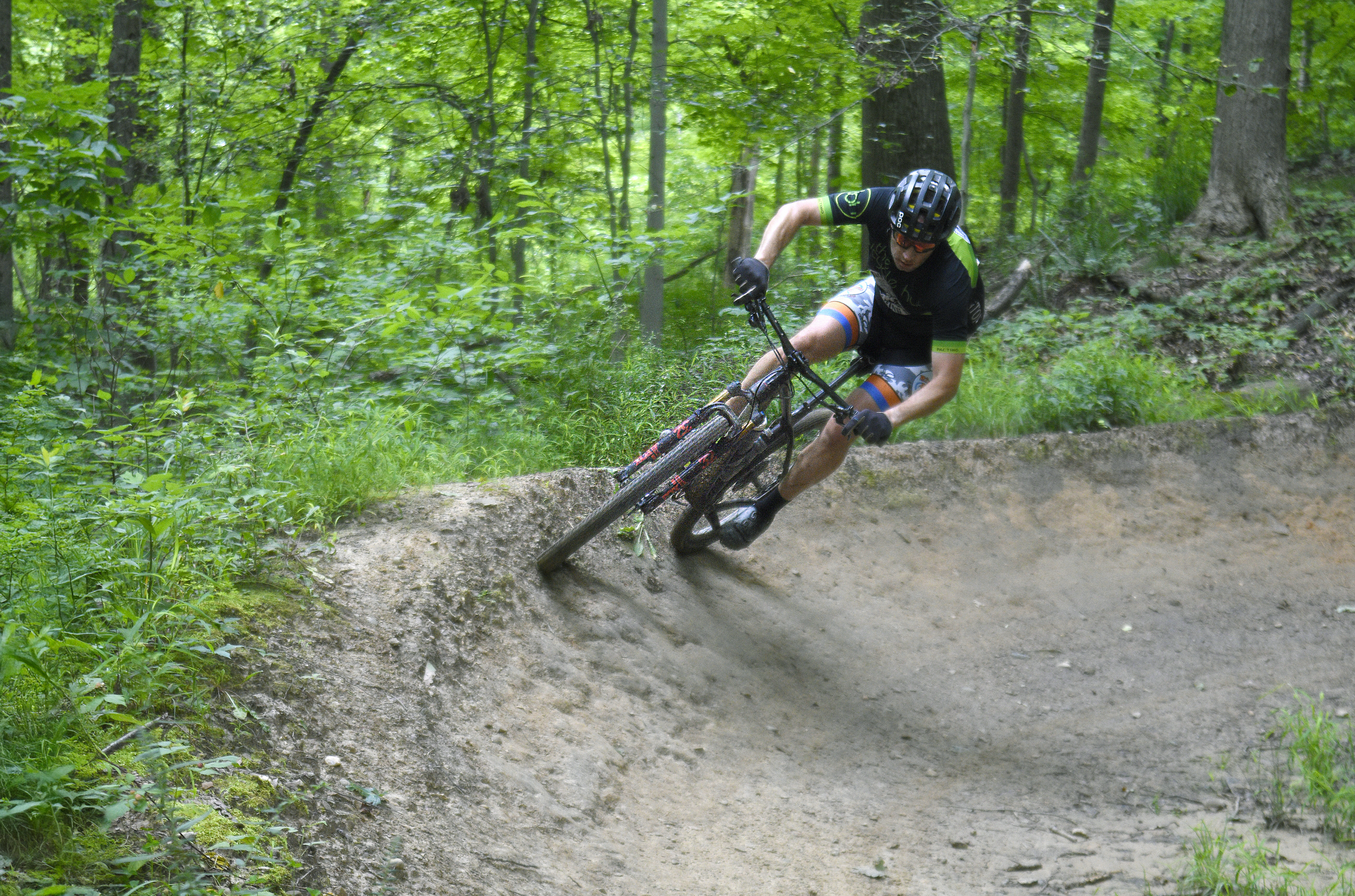
Current East Rim Trail Status
Click "more" to find out if the East Rim trails are open today. In good conditions the trails are open 6 am-11 pm for bikers and as posted for other trail users. In wet or hazardous conditions, the trail will close to all users to prevent damage.
Vehicle Break-in and Theft Warning
Car break-ins in Cuyahoga Valley have tripled since 2022, resulting in theft of personal items like credit cards. Do not leave valuables in your car. As a last resort, lock items in your trunk before arriving. Thieves target parking lots regularly.
Former Golf Course Property
The former golf course property in Peninsula, including a section of the Valley Trail, is closed during environmental remediation.
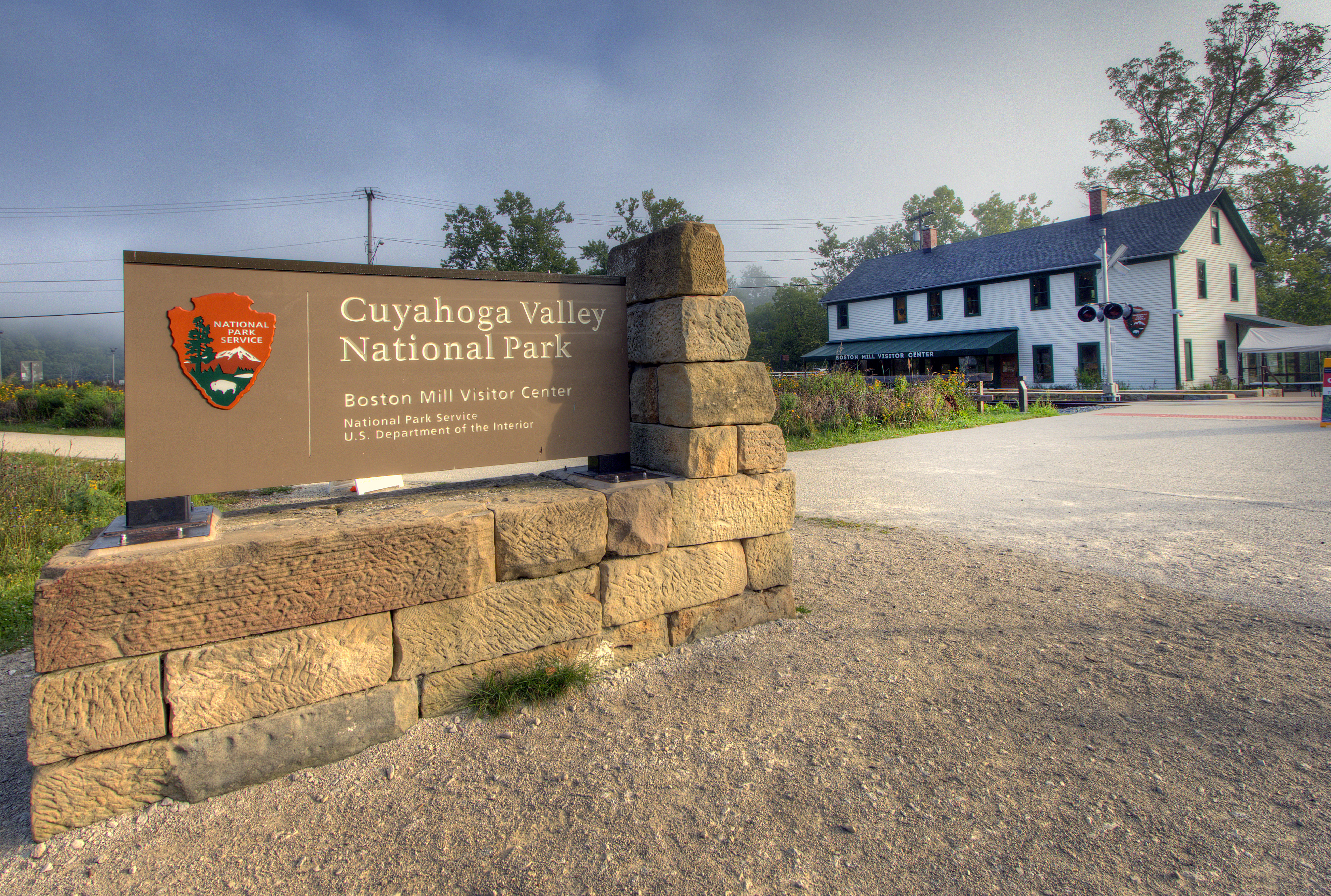
Though a short distance from the urban areas of Cleveland and Akron, Cuyahoga Valley National Park seems worlds away. The park is a refuge for native plants and wildlife, and provides routes of discovery for visitors. The winding Cuyahoga River g...
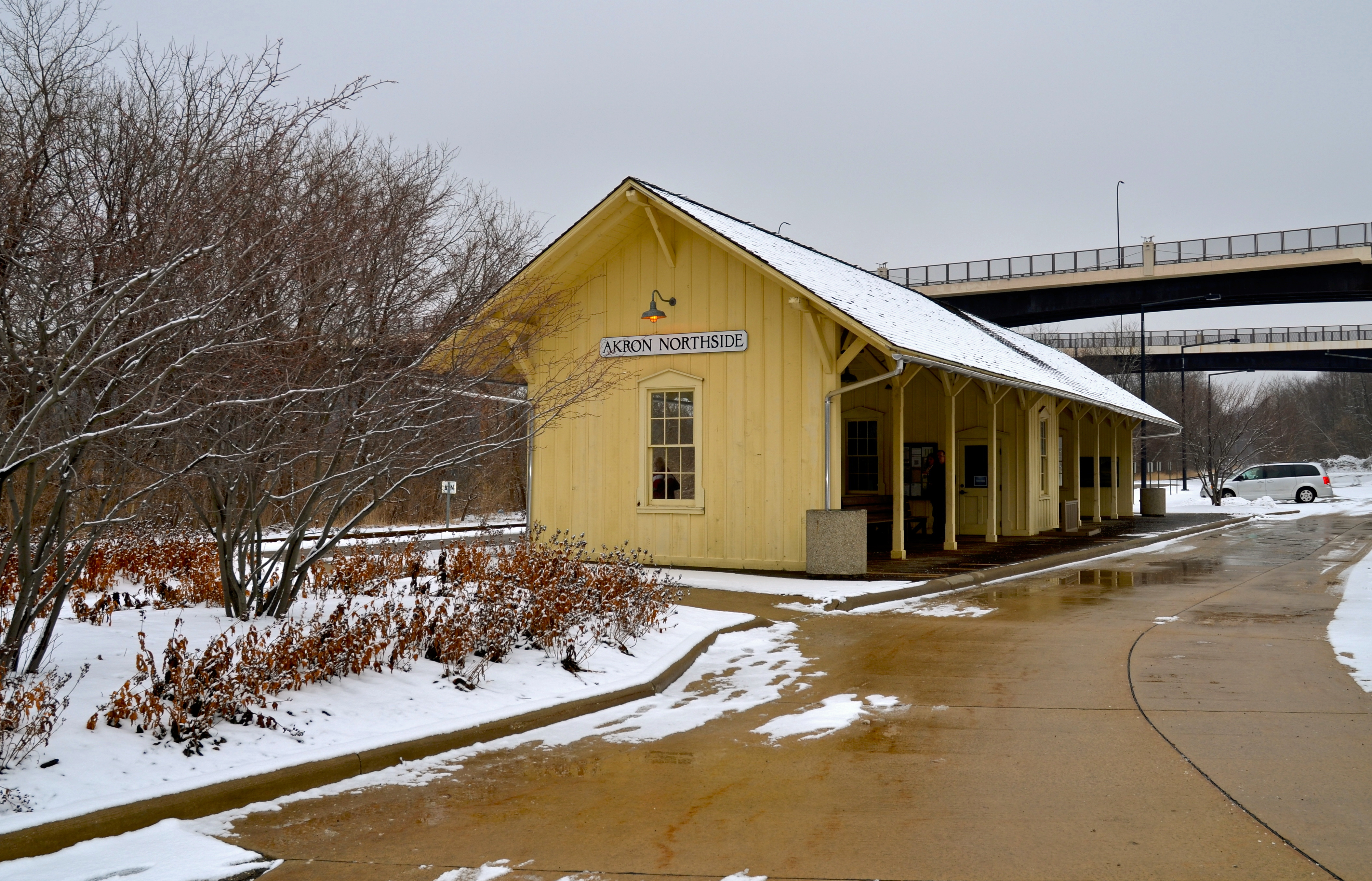
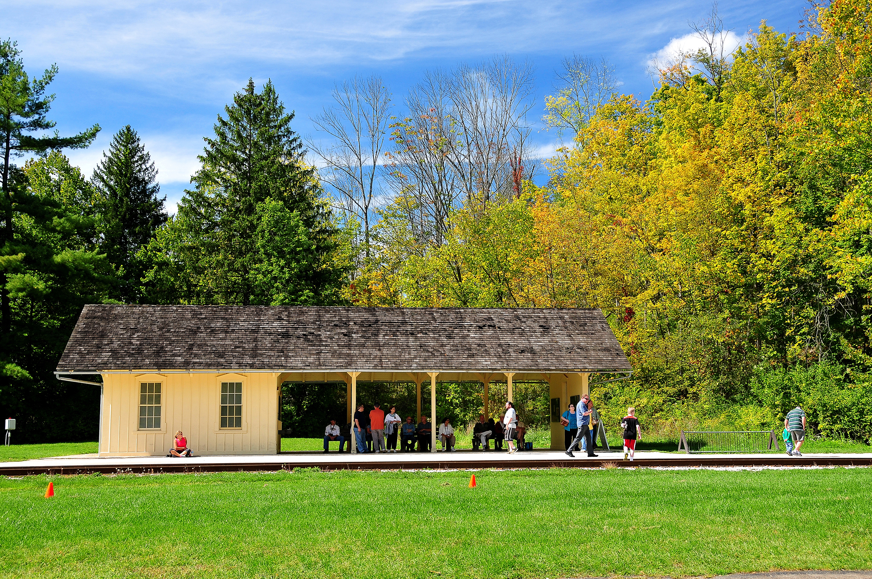
Passengers in the Akron area can catch Cuyahoga Valley Scenic Railroad at Akron Northside Station. The station has ample parking and is a primary starting point for train excursions and events into the national park. The station is on a bus line and within walking distance of shopping, dining, and the Towpath Trail.
Akron Northside Station. 450 words The rail station is a long, rectangular covered platform with a wall at each end and a small office in the middle. Posts along each side support the shingled roof. Back-to-back, wooden benches extend on either side of the office. The 20-foot-wide floor is made of wood boards and the structure is painted a creamy yellow. There is a parking lot at both ends of the station. The train tracks lie on one side of the station. On the other side, a concrete drive connects with the street. Multi-story buildings are on the other side of the street with hotels, restaurants, and shopping areas. Graphic panels are hung on the inside of the end walls. At one end is a panel titled “Ride the Rails” which explains that the first steam engine in the valley began running in 1880 connecting the mineral fields in the south to the factories in the north. Today the Cuyahoga Valley Scenic Railroad follows much of the same route. Yellow paint on a station signifies a modern building. Historical depots are painted red. The panel shows a map of the rail line through the Cuyahoga Valley National Park. The railroad and the Towpath Trail both follow the Cuyahoga River through the park. At the same end of the station is a panel titled “Cuyahoga Valley Scenic Railroad.” Text on the panel lists nearby activities and attractions such as Mustill Store (a canal-era grocery store now the focal point of Cascade Locks Park) and the Akron Art Museum. Photographs of these places extend down the right side of the panel. The wall at the other end has two graphic panels. One is titled “Creating the Valley Railway.” Text on the panel explains that the Valley Railway was a test of local perseverance. A partnership among Cleveland, Akron, and Canton, each community pledged to raise funds. Difficulties with contractors delayed the project which finally made its inaugural ride on January 28, 1880. Despite financial and construction difficulties, the railway remained independent at a time when railroads were some of the largest corporations in America. The other panel is titled “Consolidation and New Beginnings.” It explains that the Valley Railway’s independence did not last. In 1890, the Baltimore and Ohio Railroad acquired controlling interest in the railway. By 1895, after reorganization, the Valley Railway no longer existed. Just as railroads signaled a decline in the use of canals for transportation, automobiles and trucks posed a similar challenge to railroads, ending commercial use of the railway by the 1980s. The Cuyahoga Valley Preservation and Scenic Railway Association began offering excursions in 1975. Today the scenic railroad continues in partnership with the National Park Service. End of description.
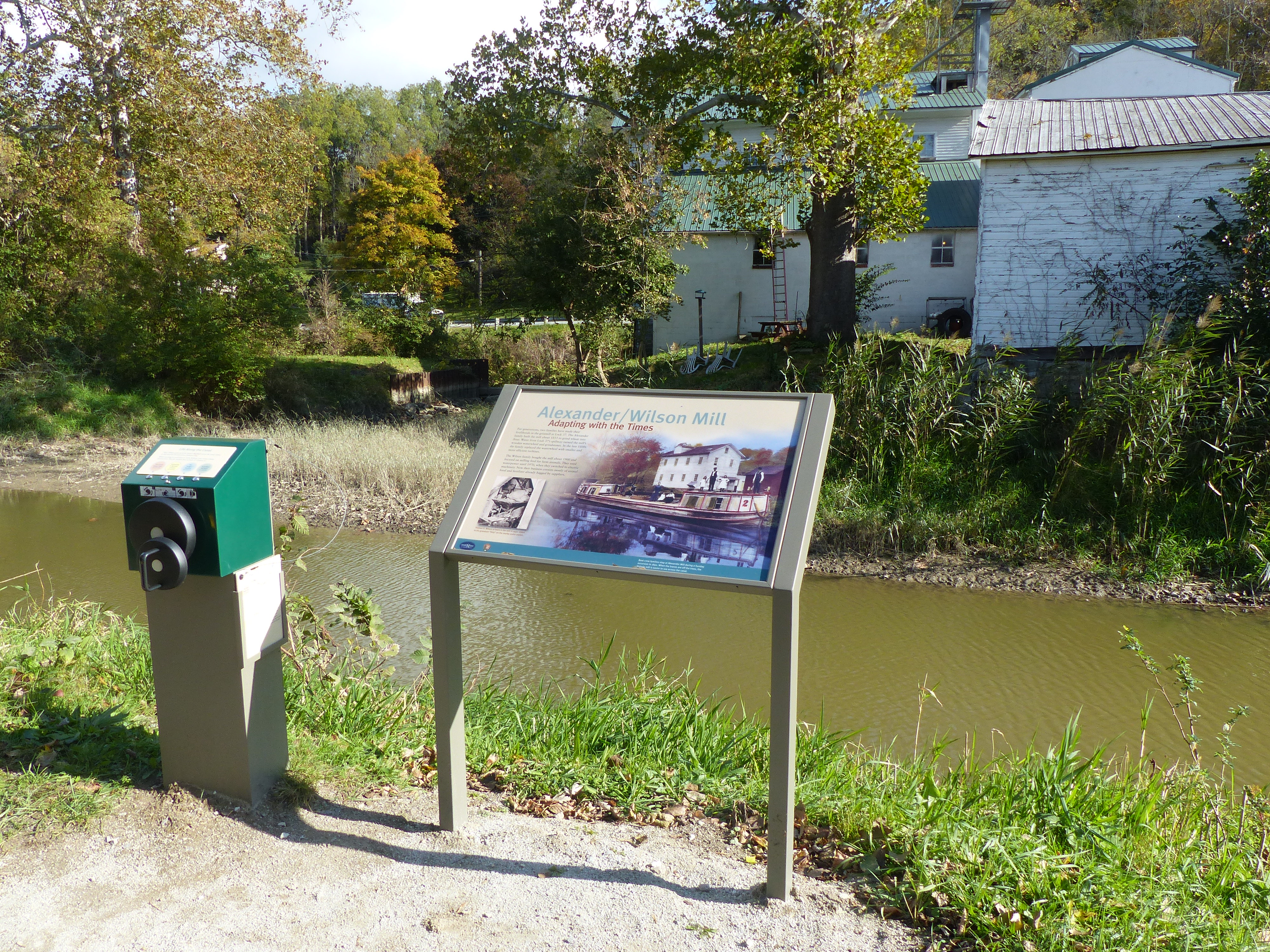
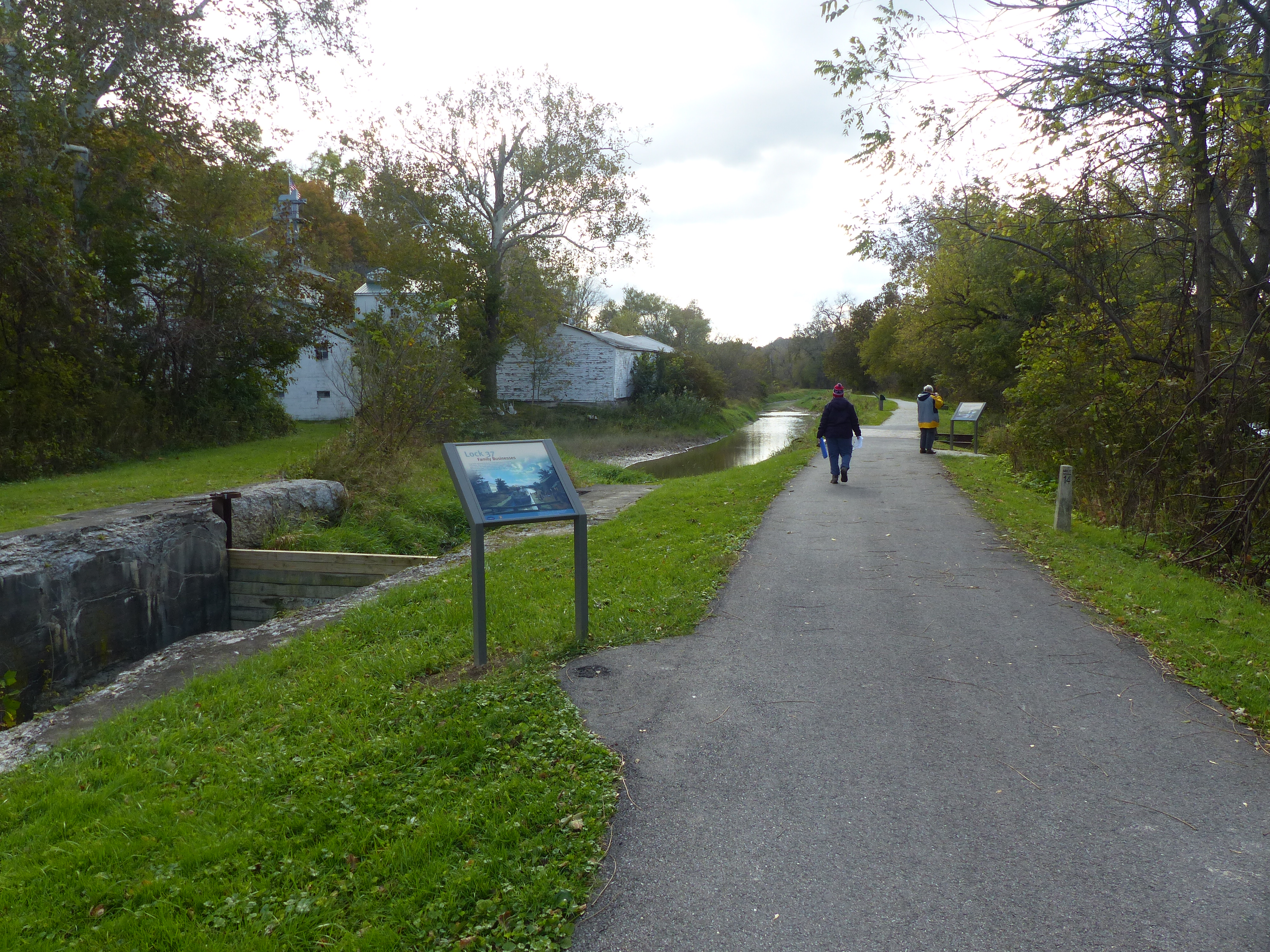
Across the canal is a historic mill. Up until 1970, it used waterpower to grind grain. The mill has been operated by two different families through several generations. It is now a feed store with pre-bagged grain.
Alexander/Wilson Mill. 453 words. Across the canal from this wayside graphic panel is a group of white, frame buildings. A long, low building with a metal roof lies alongside the canal. Beyond that are two taller buildings, both with green metal roofs. The one at the left lies parallel to the canal and has a small cupola with a flag on top; the other sits perpendicular to it. On the other side of the buildings is the scenic byway. A gravel parking lot lies to the right of the group of buildings with palettes of sacks stacked along the edge. Behind the buildings, to the left, a shallow spillway diverts excess water around Lock 37. Text on the panel reads, “Adapting with the Times. For generations, two families have made their livelihoods in the gristmill at Lock 37. The Alexander family built the mill about 1853 to grind wheat into flour. Water from Lock 37’s spillway turned the mill’s wooden waterwheel and grindstones. In the late 1800s the family replaced the waterwheel with smaller and more efficient turbines. The Wilson family bought the mill about 1900 and focused on milling feed for farm animals. They used water power until 1970, when they switched to electric machinery. Now their business consists mostly of animal food and fertilizer already bagged by suppliers.” The background of the panel features an 1890 colorized image of boat crew families stopping at Alexander Mill during a Sunday excursion. The image shows a long boat in the canal with the white mill building behind. The boat has cabins at the front and rear, with a flat deck in the middle. A woman, three men and three girls stand or sit on the boat. At the lower left is a black and white photograph of a man wearing work clothes and a billed cap lifting a cloth bag over a large, square funnel. The caption reads, “Thomas G. Wilson at work in the mill in 1940. Listen to his grandson “Skip” on the nearby audio station.” To the left of the graphic panel is a metal post with four push buttons on top. A small panel reads, “Life Along the Canal. “Skip” Wilson grew up in his family’s feed mill across the canal. Listen to him describe his experience, buttons 1-3. While traveling by canal boat in 1838, William Case wrote a funny journal entry. Was the incident here at Lock 37? Button 4.” The buttons are labeled: 1, The Finest Bread Flour, 50 seconds; 2, Swimming in Kernels of Corn, 25 seconds; 3, The Legger Elevator, 40 seconds; and 4, A Hubbub All Night, 60 seconds. The audio is powered by a hand crank on the front of the post. End of description.
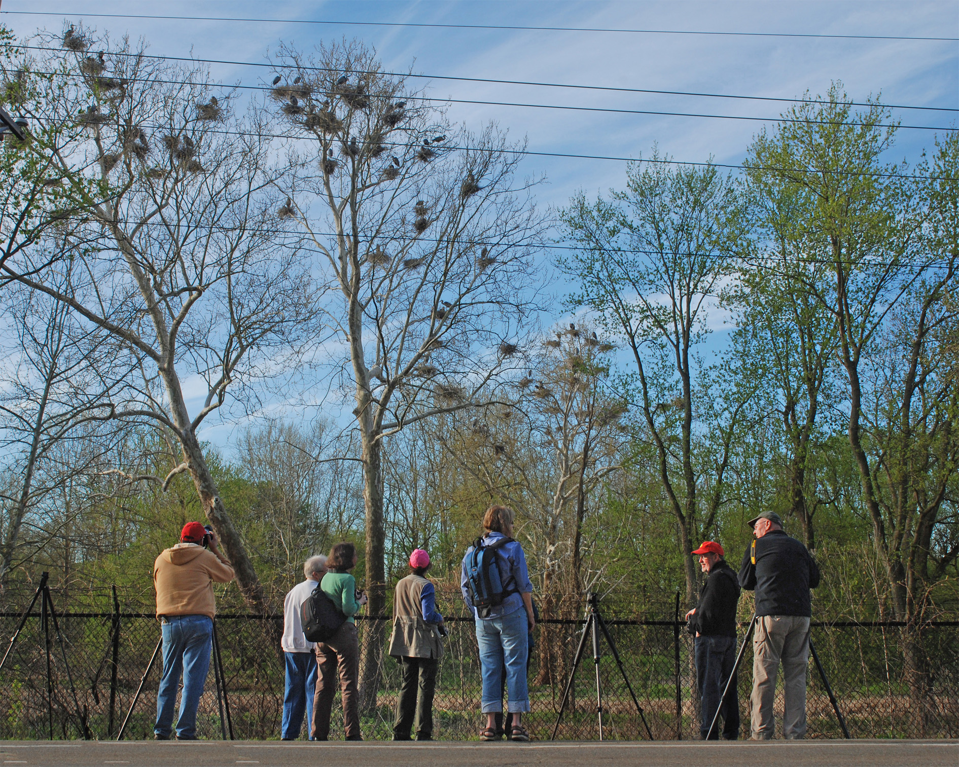
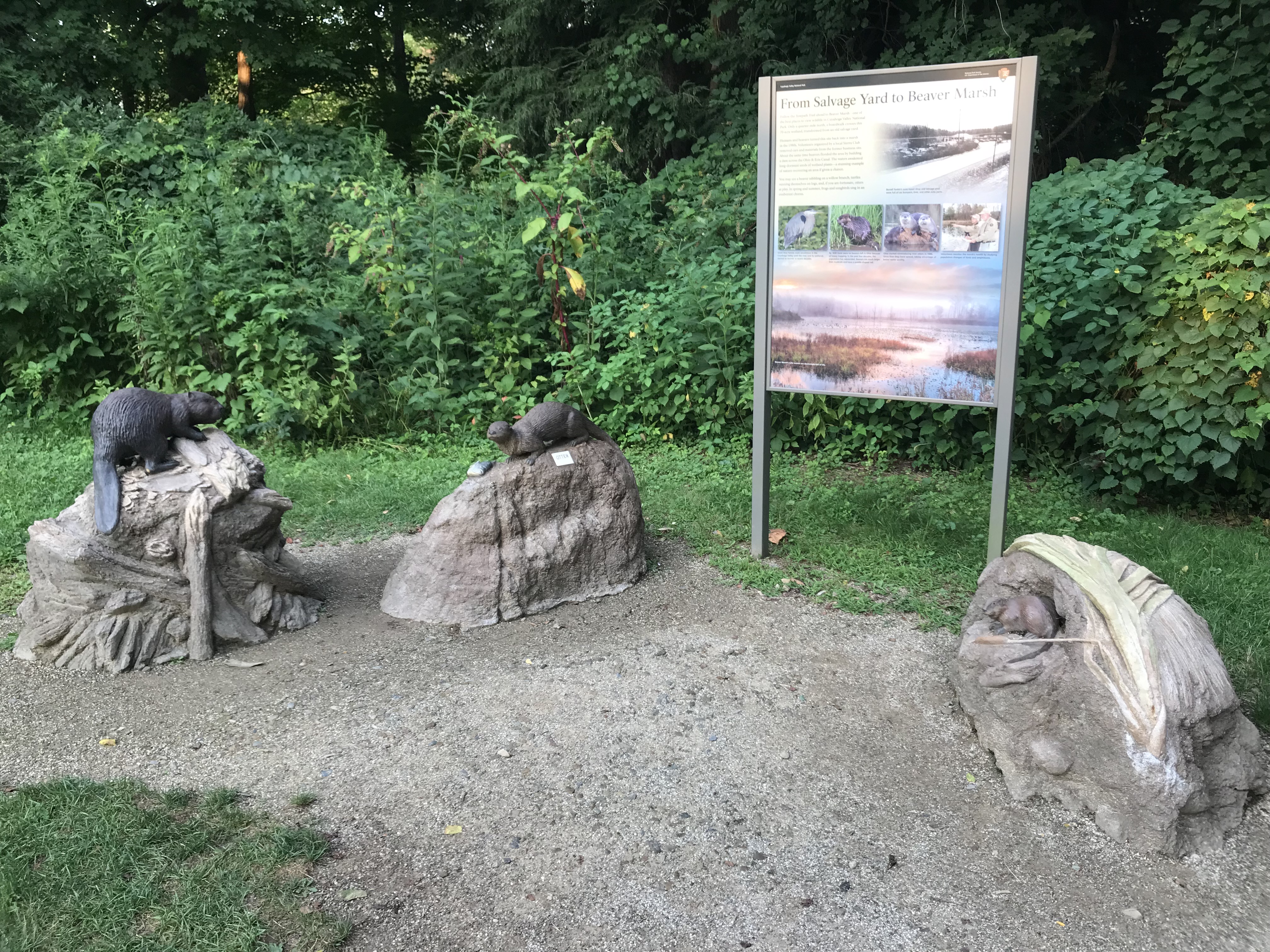
The Bath Road Heronry is a pull off along Bath Road, with exhibit panels telling about these prehistoric birds. Unique in that you can see and hear these birds without ever leaving the car!
Bath Road Heronry. 373 words This wayside graphic panel sits at the side of Bath Road. As you face the graphic panel, you are looking over the road to a floodplain forest with scattered tall trees on the other side. Near the tops of many of the trees are large nests in places where the branches fork. Behind you is a thinly forested area. Text on the panel reads, “Treetop Territory. A heronry, like the one across the street, is a nesting area created high in the treetops by great blue herons, ‘Ardea herodias.’ This migratory bird is an impressive and common sight in the Cuyahoga Valley. Males typically return to the heronry in early February to select a nesting site. Females arrive a few weeks later to find a mate. Courtship establishes a season-long bond. Females lay 3 – 7 eggs, which hatch late April or early May. Young birds can be seen in the nests from late May until they fledge in July. “Nests are constructed of twigs and lined with soft material like moss and leaves. As nesting trees have fallen, some herons have built nests along the Cuyahoga River north of Bath Road. The success of nesting colonies in the valley reflects favorable habitat protected by the National Park Service, City of Akron, and other organizations and privative individuals.” The middle of the panel has a photograph of a heron perched on top of a nest. The large mass of twigs is balanced on top of bare, vertical branches. Down the right side of the panel are three drawings of herons: a courting couple exchanging a twig, one perched on a branch, and an adult offering food to a young bird. Captions read, “Courtship displays are important for attracting a mate and maintaining the pair bond. Male herons present sticks to females, reinforcing bonding and territory acceptance. Watch for these displays February through April. “Great blue herons feed primarily on fish and small aquatic animals. They hunt by stealth, standing motionless until stabbing or grabbing prey with their long bill. “The blue heron is call GREAT for good reason. These wading birds stand four feet tall, have a wingspan of nearly seven feet, and weigh between five and eight pounds.” End of description.
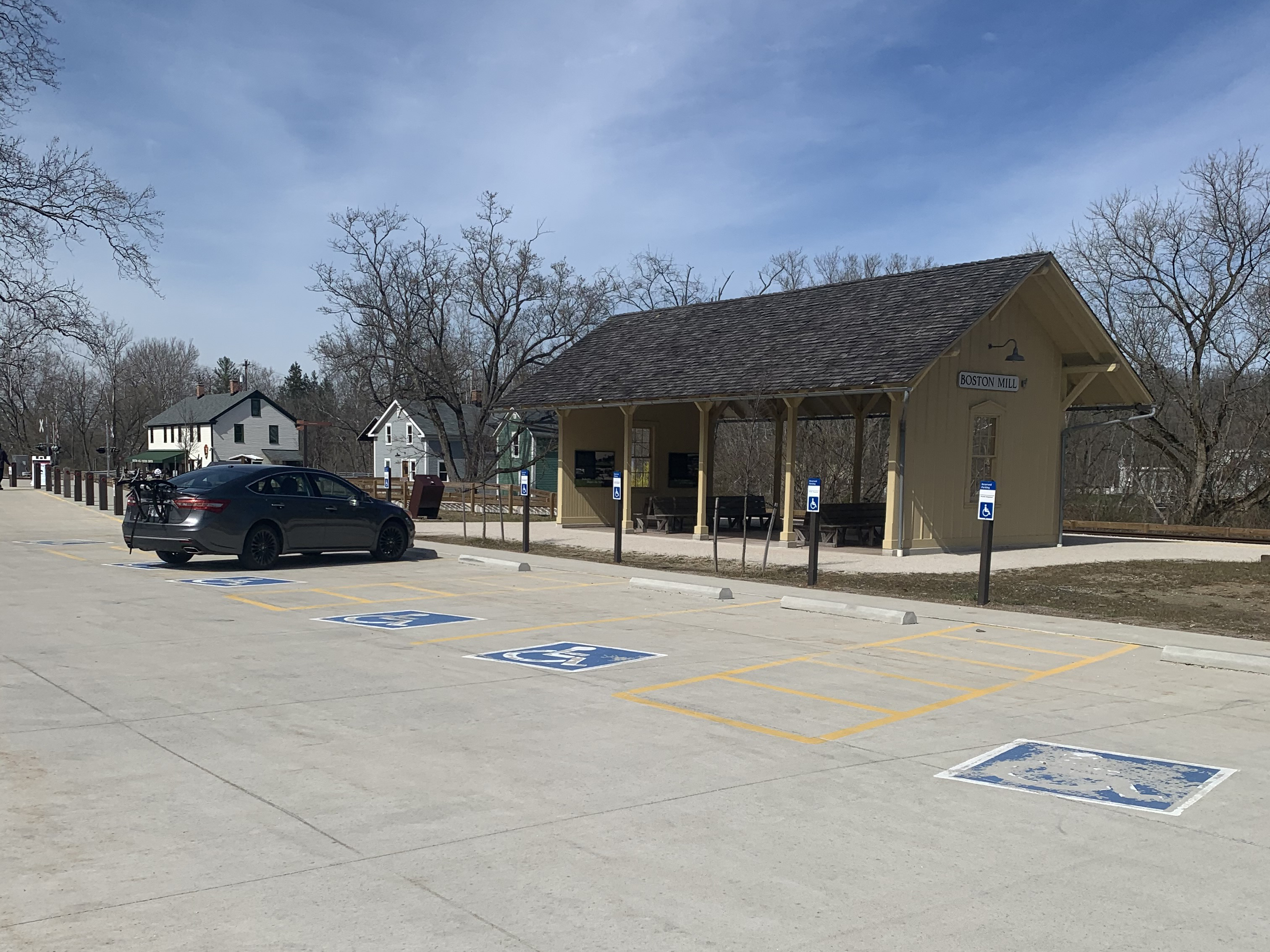
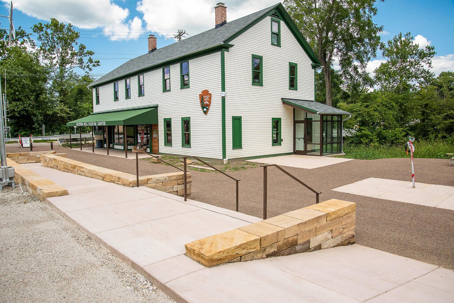
Boston Mill Station is a Cuyahoga Valley Scenic Railroad flag stop. Passengers can get off the train to visit Boston Mill Visitor Center, the pedestrian friendly village of Boston, and nearby trails. Bicyclists, runners, hikers, and paddlers can access the train’s one-way shuttle service to create a trail-train adventure.
Boston Mill Station. 458 words This rail station is a rectangular covered platform with a wall at each end. Posts along each side support the shingled roof. Wooden benches sit on either side of the office. The 20-foot-wide floor is made of wood boards and the structure is painted a creamy yellow. The railroad tracks are on the backside of the station. On the far side of the depot is the Cuyahoga River with the village of Boston beyond that. On the near side of the station is the Boston Mill parking lot and beyond that, the scenic byway. Graphic panels are hung on the inside of the end walls. At one end is a panel titled “Ride the Rails” which explains that the first steam engine in the valley began running in 1880 connecting the mineral fields in the south to the factories in the north. Today the Cuyahoga Valley Scenic Railroad follows much of the same route. Yellow paint on a station signifies a modern building. Historical depots are painted red. The panel shows a map of the rail line through Cuyahoga Valley National Park, stretching from Rockside Station at the northern end to the Akron Northside Station at the southern end. The Boston Mill Station is near the middle of the park. The railroad and the Towpath Trail both follow the Cuyahoga River through the park. Near that panel is a glass-covered bulletin board with current information about the train and the park. The wall at the other end has two graphic panels. One is titled “Industry Shapes the Valley.” It features a 1915 photograph of the Boston Mill Depot, which was moved to Peninsula in 1968 and now serves as the Peninsula Depot. Text on the panel explains that industry changed the physical appearance and social composition of the valley. In 1900, the Cleveland Akron Bag Company located its factory next to the railroad tracks with a company store and workers houses nearby, changing the orientation of the village to the tracks and the factory. To the north, no village existed at Jaite until the Jaite Paper Mill began operations and erected a general store, boarding house, post office, and homes for some of its workers. The other panel is titled “The Development of Valley Industry.” Text on the panel reads in part, “In 1900, the Cleveland Akron Bag Company began operations in Boston, producing flour sacks and roofing paper until going out of business in 1923. A former employee of that company, Charles Jaite, was responsible for the second paper producer, the Jaite Paper Mill, which opened in 1905 about two miles north of Boston. It remained in business under various owners until 1984.” Photographs on the panel show views of the bag factory and of machinery inside the paper mill. End of description.
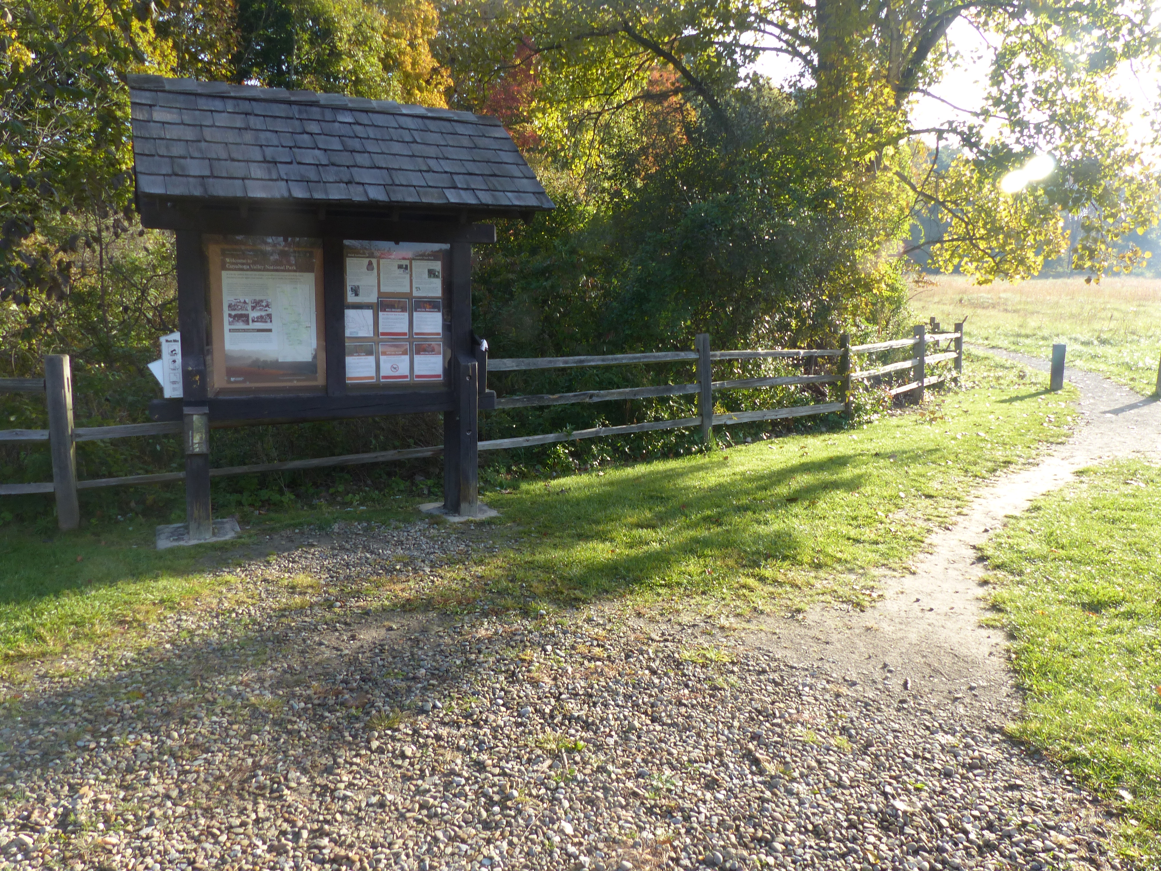
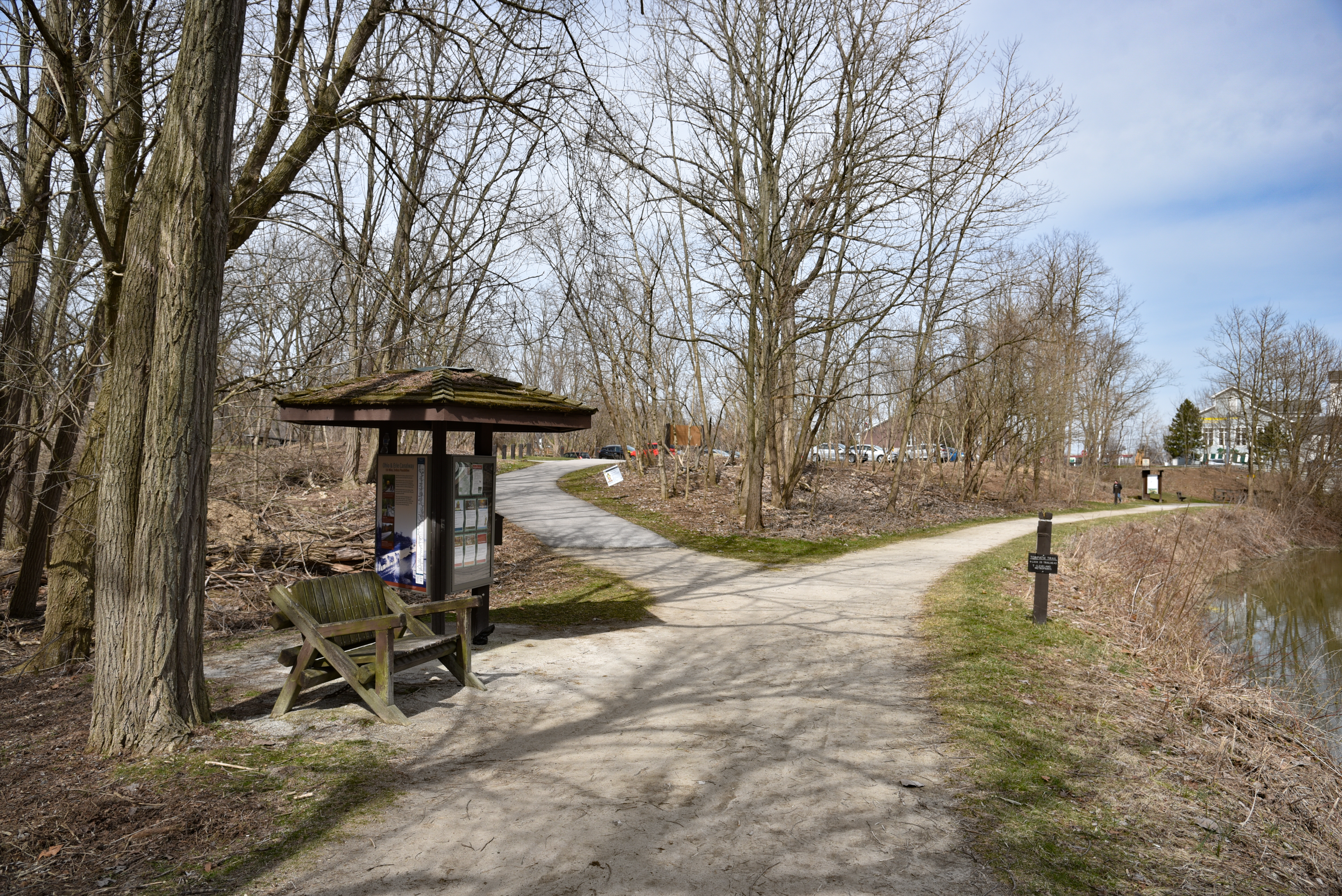
The far corner of the main parking lot for Happy Days Lodge provides access to Boston Run Trail. This 3.1-mile loop explores the woods and ravines along a headwater stream of the Cuyahoga River.
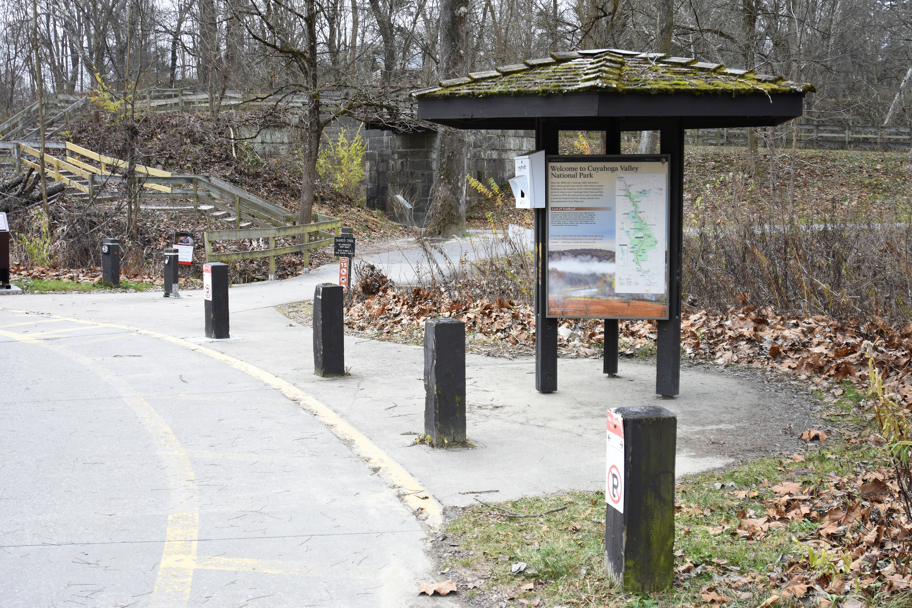
Boston Run Trailhead. 283 words Here at the side of the parking lot is a covered kiosk with a bulletin board and a graphic panel. Along the right side of the kiosk an unpaved trail leads off between a meadow on its right and woods on its left. A wood rail fence runs along the edge of the woods. On the far side of the trail is a small grassy area with picnic tables. To the left of the kiosk is a bench. The graphic panel on the kiosk is titled “Welcome to Cuyahoga Valley National Park” and features a map of the park stretching along the Cuyahoga River with your current location near the eastern edge of the park indicated. Text on the panel reads, “Since the 1800s, the Cuyahoga Valley has been a place where people from nearby cities relax in nature. Building on this tradition, locals worked tirelessly to preserve what is now Cuyahoga Valley National Park. Created in 1974, the park protects open countryside, a canal that helped build the nation, and the river that sparked the Clean Water Act. “Boston Run Trailhead. Boston Run is a one of many headwater streams that flow into the Cuyahoga River. It winds in and out of view as you travel the serene ravines and ridges of this trail loop. Notice how the surrounding forest shades the stream. Cool water temperatures allow pollution sensitive salamanders and the tiny insects they eat to survive. The roots of the oak, maple, beech, and tulip trees hold soil in place and soak up excess water, reducing downstream flooding.” The bulletin board to the right includes a map of the trail, which makes a 3.1-mile loop. End of description.
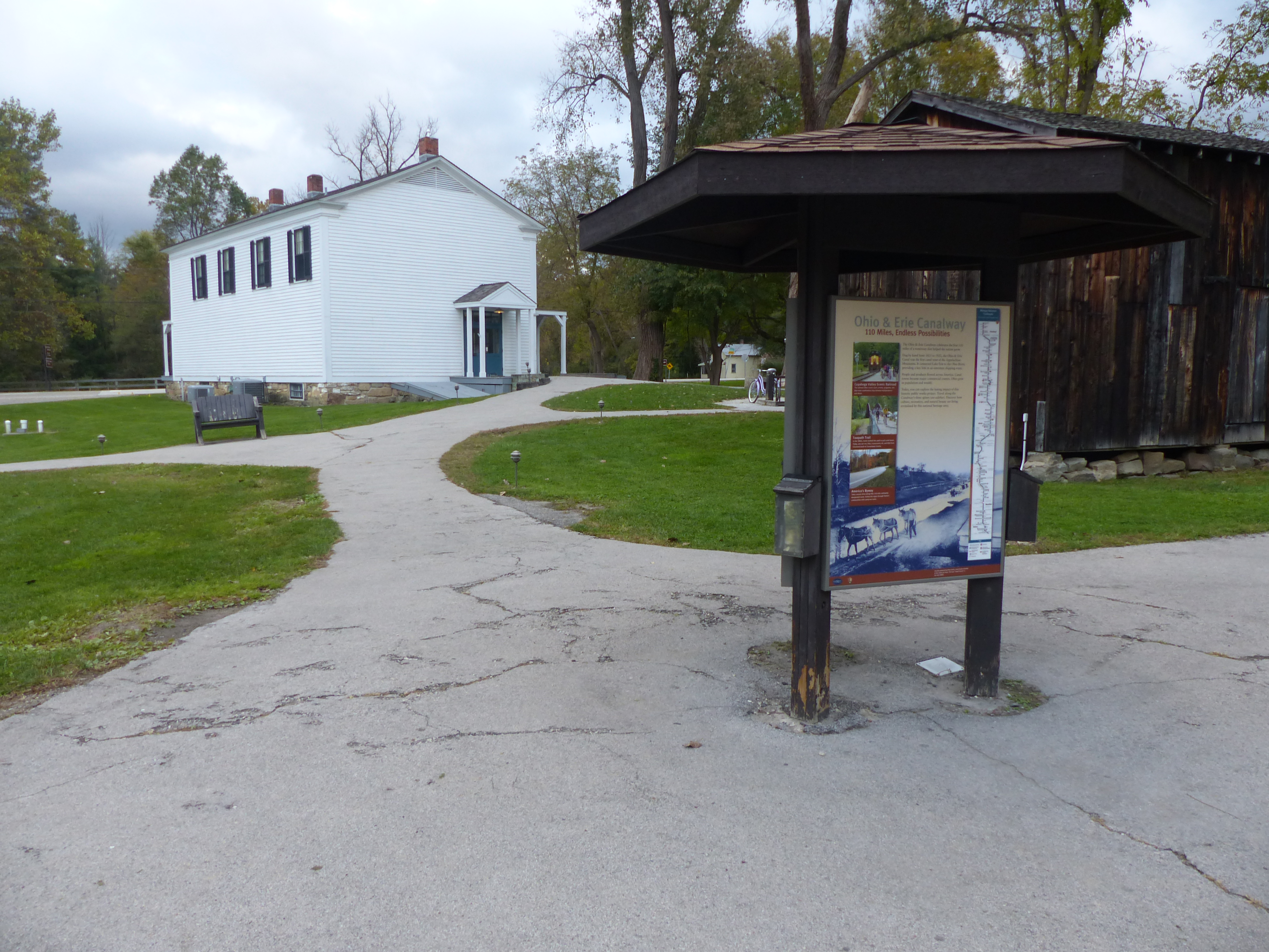
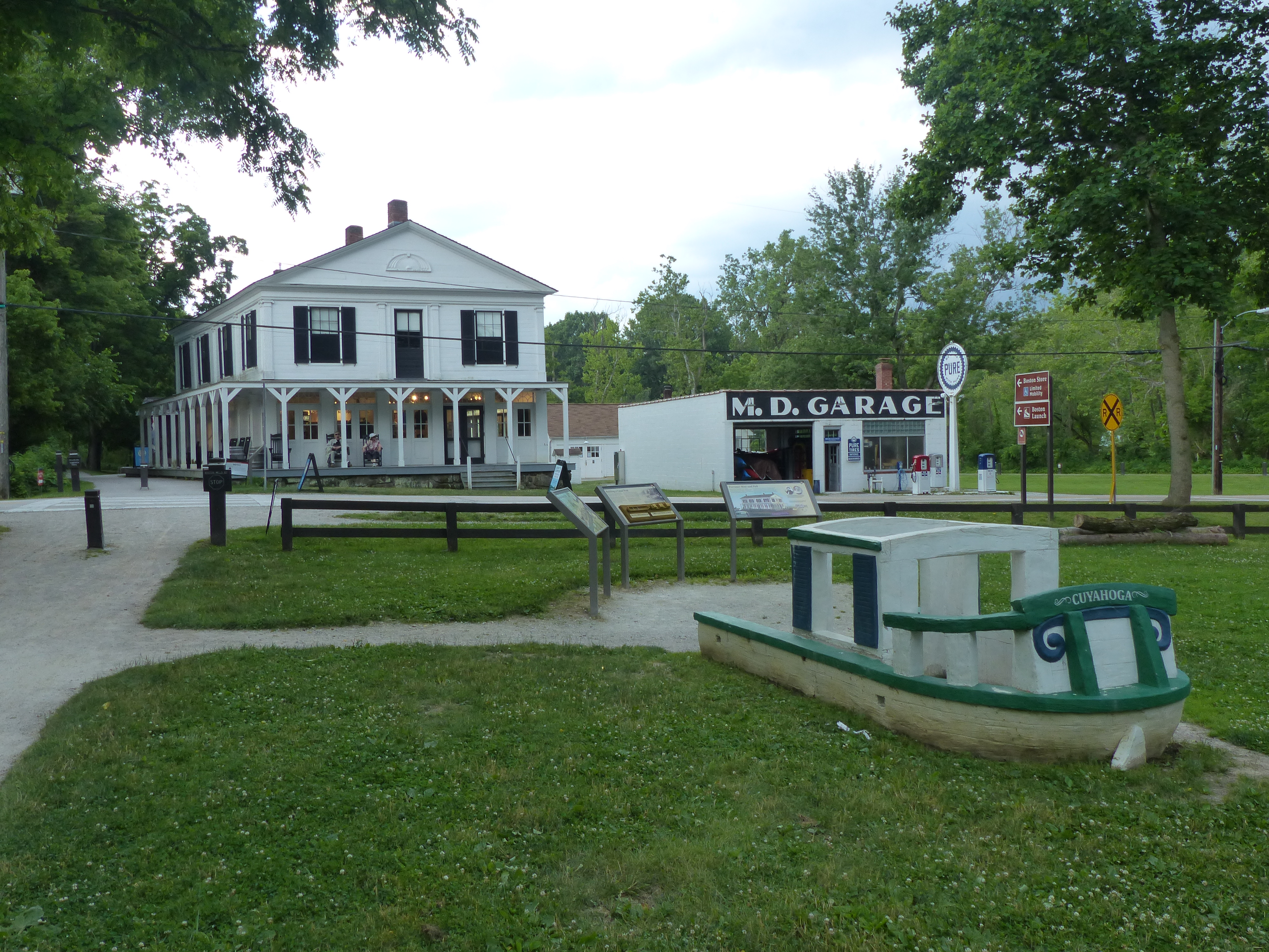
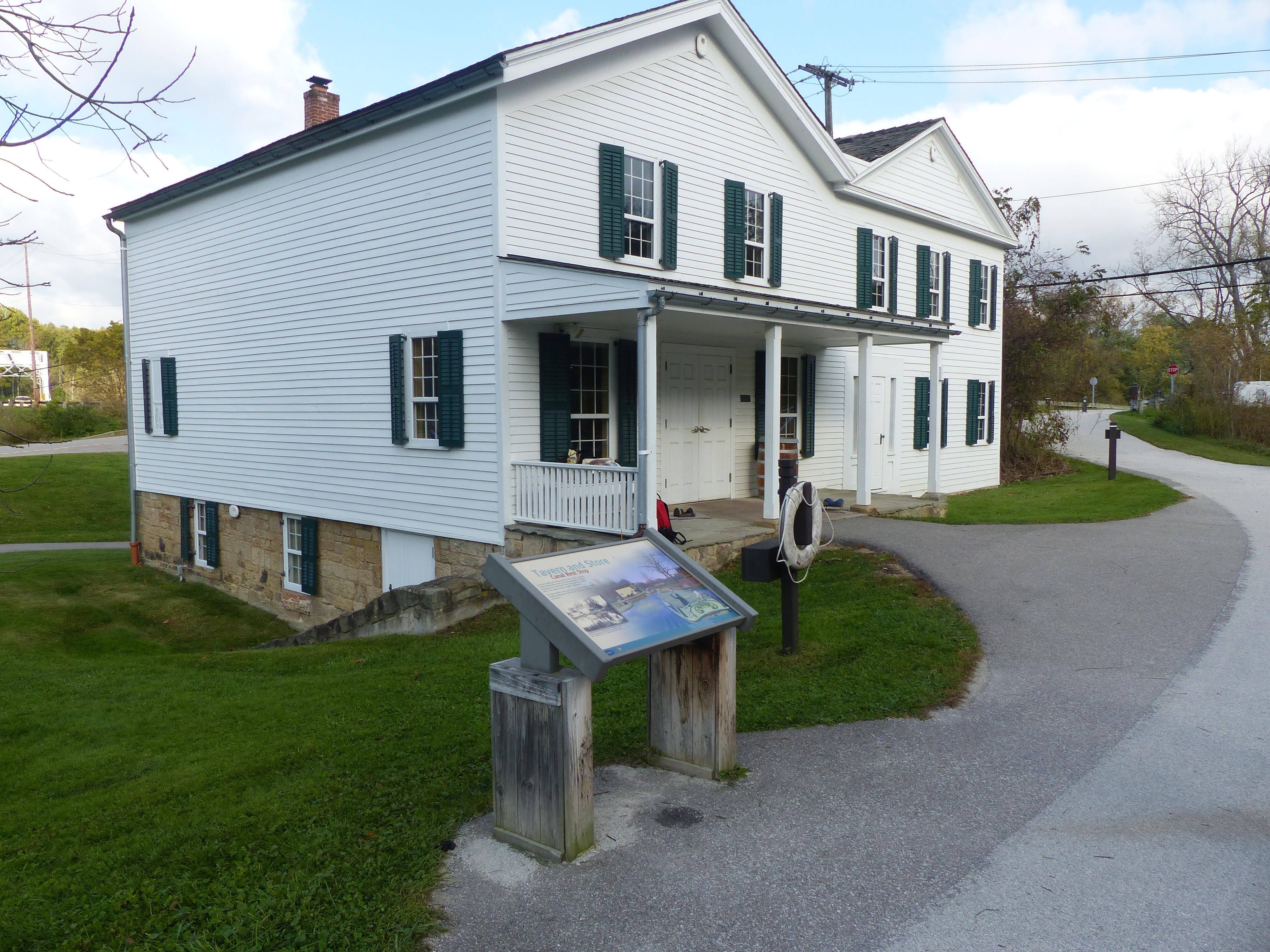
The Village of Boston grew up alongside a canal on the east side of the Cuyahoga River and a railroad on the west side of the river. Boston Store Trailhead provides limited mobility parking on the east side. Use it to access the Ohio & Erie Canal Towpath Trail and refreshments at Boston Store. This small trailhead does not accommodate over-sized vehicles.
Boston Store Trailhead. 474 words A three-sided, covered kiosk with a bulletin board and two graphic panels sits at the side of the parking lot here behind the two-story, white Boston Store. Standing with your back to the parking lot, the Towpath Trail is to your right with the dry canal bed on the far side. These continue along the right side of Boston Store. To the left of the kiosk is a white building with restrooms, with entrance on the far side of the building. Between the restrooms and Boston Store is the M.D. Garage, its front facing the street on the opposite side. One of the graphic panels is titled “Welcome to Cuyahoga Valley National Park” and features a map of the park stretching along the Cuyahoga River with your current location here in Boston near the center of the park marked. Text on the panel reads, “Since the 1800s, the Cuyahoga Valley has been a place where people from nearby cities relax in nature. Building on this tradition, locals worked tirelessly to preserve what is now Cuyahoga Valley National Park. Created in 1974, the park protects open countryside, a canal that helped build the nation, and the river that sparked the Clean Water Act. “Boston Store Trailhead. Boston was once a bustling canal town with a lumberyard, brickyard, boatyards, and mills. Later it was a company town for a paper bag factory. Today, Boston is the heart of Cuyahoga Valley National Park. Stop at the visitor center to plan your adventure. Hike a short distance north on the towpath and follow connecting trails about 2.5 miles to the 60-foot Brandywine Falls, a favorite park attraction. Walk or bike 2.3 miles south to historic Peninsula for dining and shopping.” The third side has a panel titled “Ohio and Erie Canalway” with a large black and white photograph of three mules pulling a canal boat on the canal. Smaller photographs show the Cuyahoga Valley Scenic Railroad, a group of children riding bicycles on the towpath, and the scenic byway that winds through the valley. A long map down the right side shows mileage between trailheads on the Towpath Trail. Text on the panel reads, “The Ohio and Erie Canalway celebrates the first 110 miles of a waterway that helped the nation grow. Dug by hand from 1825 to 1832, the Ohio and Erie Canal was the first canal west of the Appalachian Mountains. It connected Lake Erie to the Ohio River, providing a key link in an interstate shipping route. People and products flowed across America. Canal towns became major commercial centers. Ohio grew in population and wealth. Today you can explore the lasting impact of this historic public works project. Travel along the Canalway’s three spines. Discover how culture, recreation and natural scenic beauty are being revitalized by this national heritage area.” End of description.
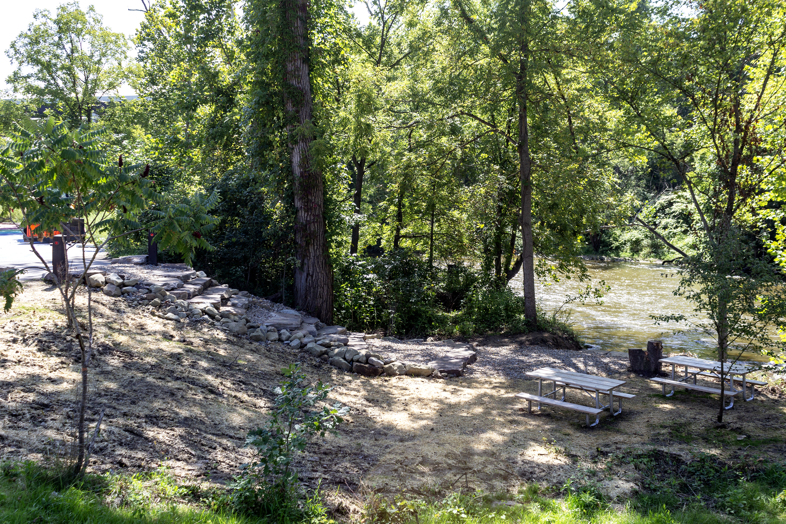
Access the river from Boston Store Trailhead in the Village of Boston. Boston Mill Visitor Center is nearby.
Boston Store Trailhead River Access. 178 words The Cuyahoga River Water Trail access at Boston Store Trailhead is located on the east bank of the river. The path to the river access starts on the west side of the parking lot. It has spaced out timbers steps as the trail descend toward the water. There is a sign on the right with paddler information and hazards. When you reach the access point, the river will be in front of you. The ground flattens out as you reach the water. The terrain at water’s edge is loose dirt and rocks. Interstate bridges are visible high to the left, crossing over the top of the valley. The banks to the left are steep with grass and trees. The Boston Mills Road bridge is visible downriver to the right. The terrain to the right has large rocks that lead into the river. Across the river to the right is the Boston Mill Visitor Center, white with green. Directly across the river is the yellow Boston Mill Station, serving the scenic railroad. End Description.
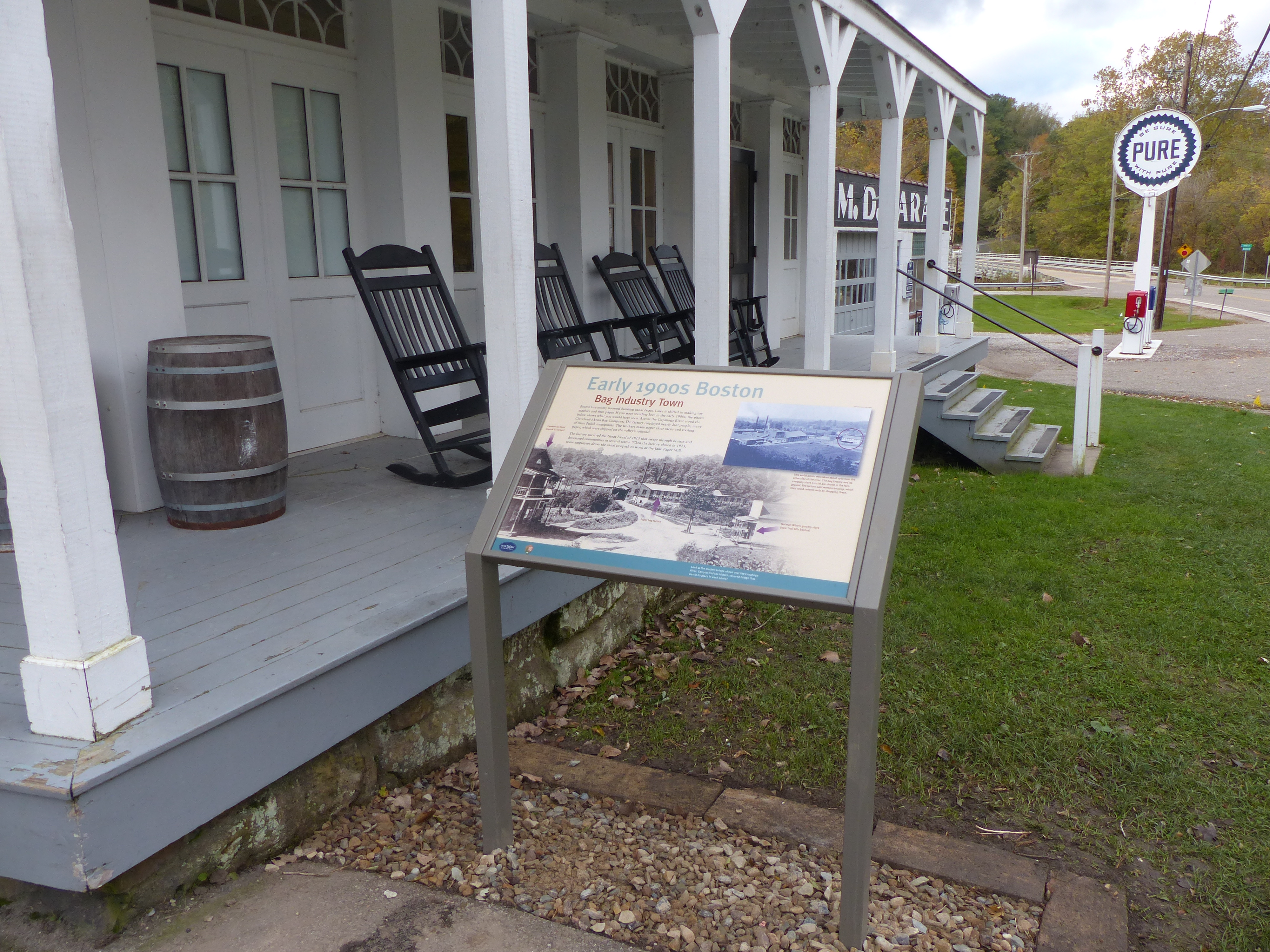
Boston boomed with the arrival of the Ohio & Erie Canal in 1827. It boomed again when a paper mill, the Cleveland Akron Bag Company, opened in 1902. This exhibit shows an early 1900s view of Boston Mills Road when the bag company dominated the town.
Boston Street View. 460 words This wayside graphic panel sits at the corner of the towpath and Boston Mills Road, just in front of the Boston Store. As you face the sign, the towpath to the left runs along the wide covered porch on the side of the two-story, white frame building. The porch wraps around this corner to run along the front of the building as well, with rocking chairs spaced all along it. From the path, the porch is one step up. In front of the building, it is higher, with a set of five steps in front of the door at the far end. The upper floor is lined with windows with dark green shutters. Behind you is the wide, dry bed of the canal. The street lies to your right. Past the Boston Store on this side of the street is the old M.D. Garage with vintage gas pumps in front. Across the street from that is a small white building which houses the Trail Mix Boston store. From there the street continues over the Cuyahoga River and the train tracks beyond. The graphic panel is titled “Early 1900s Boston, Bag Industry Town.” The bottom has a black and white photograph showing the view down this street in the early 1900s. A two-story building housing the Commercial Hotel stands where the M.D. Garage is now located. The Trail Mix building with the covered porch across the street was Norman Wise’s grocery store. A covered bridge went over the river. On the far side was a long factory building with a tall smoke stack which was the paper bag factory. In the upper right is a 1910 aerial view from the other side of the river. The factory complex fills the lower left corner. The covered bridge is visible toward the right side of the image next to a two-story white building on that side of the river, which was the company store. The caption reads in part, “The factory workers were paid in scrip, which they could redeem only by shopping there.” Text at upper left reads, “Boston’s economy boomed building canal boats. Later it shifted to making toy marbles and then paper. If you had been standing here in the early 1900s, the photo below shows what you would have seen. Across the Cuyahoga River stood the Cleveland Akron Bag Company. The factory employed nearly 200 people, many of them Polish immigrants. The workers made paper flour sacks and roofing paper, which were shipped on the valley’s railroad. The factory survived the Great Flood of 1913 that swept through Boston and devastated communities in several states. When the factory closed in 1923, some employees drove the canal towpath to work at the Jaite Paper Mill.” End of description.
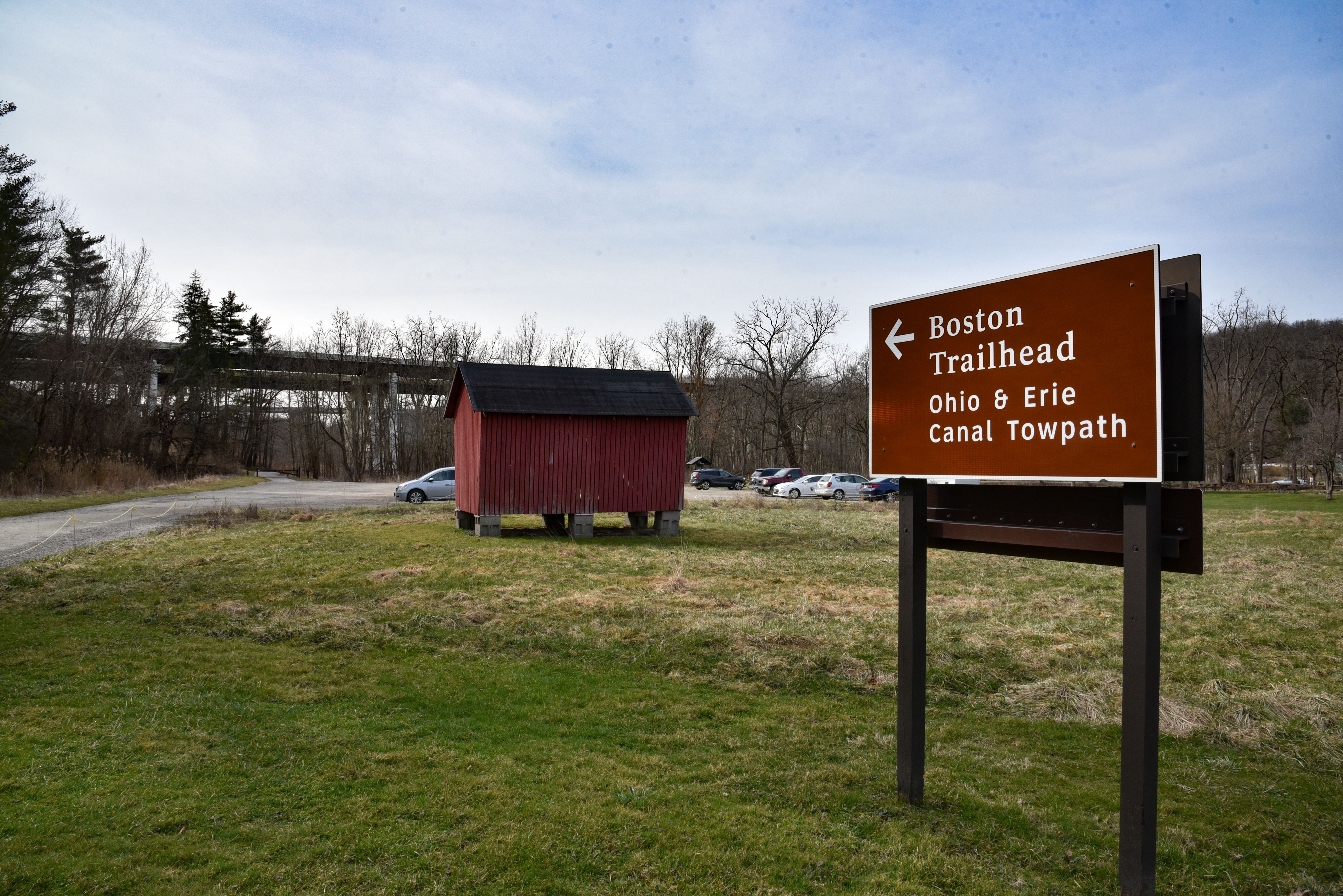
The Village of Boston is a crossroads for hikers, cyclists, runners, paddlers, and horse riders. Boston Trailhead provides parking for the Ohio & Erie Canal Towpath, Valley, and Buckeye trails. Paddlers may park their vehicles at the trailhead after unloading equipment at the Cuyahoga River Water Trail drop-off. Horse trailers are permitted. However, the parking lot was not designed to accommodate them, and it can be a challenge to navigate.
Boston Trailhead. 235 words A covered kiosk with a bulletin board and a graphic panel sits at the side of this unpaved parking lot. On the far side of the kiosk is the dry bed of the canal. The Towpath Trail runs along the opposite bank. Behind you on the other side of the parking lot is a paved trail that leads to your left and connects with the towpath. The graphic panel is titled “Welcome to Cuyahoga Valley National Park” and features a map of the park stretching along the Cuyahoga River with your current location near the middle of the park marked. Text on the panel reads, “Since the 1800s, the Cuyahoga Valley has been a place of retreat from urban life. Building on this tradition, citizens worked tirelessly to preserve what is now Cuyahoga Valley National Park. Created in 1974, the park protects open countryside, a canal that helped build the nation, and the river that sparked Earth Day and the Clean Water Act. “Boston Trailhead. The village around you was once a busy community of nearly 1,000 people. Boston has seen a number of industries throughout the years, including canal boatyards, hotels, and mills. Although smaller today, the community of Boston is still vibrant. Local residents go about their daily lives alongside visitors who come to hike and bike the Towpath Trail, get park information, buy refreshments, or rest a minute.” End of description.
Explore how Boston boomed during the canal era at this outdoor interpretive display. Boston’s success came in part from its role in boat building. Exhibits feature Boston’s boatyards, the basics of canal boat building, and other canal era businesses. A play structure provides a hands-on canal boat experience.
Boston Village. 439 words At this location the towpath crosses Boston Mills Road which runs through the village. As you face the street, to the right are three wayside graphic panels next to a half-size canal boat play structure. To the left is the wide, dry canal bed. The historic Boston Store is across the street on the right side of the towpath. The canal boat structure lies parallel to the path with its stern to the right. It has a single cabin at its left end and features a wheelchair-accessible cement deck. The panel at the side of the path closest to the structure is titled “Bustling Boat-Building Village.” It features a drawing of a bird’s-eye view of the village in 1856 showing a bustling boatyard on the far side of the canal from your current location, a blacksmith shop next to the road on that side, and a lumberyard across the canal from the Boston Store. Boston has three boatyards at that time. During the canal’s heyday, about half of the boats on the canal were built in Boston and Peninsula. The panel to the left of that one is titled “Building a Canal Boat” and has two touchable models of canal boats along its bottom edge. The model at left has only the hull, so you can feel the keel and ribs on the inside of the boat. The model at the right is a completed cargo boat with three cabins spaced along its deck. Text on the panel explains that the size and shape of a canal boat was determined by the smallest lock, which on the Ohio and Erie Canal is 75 feet long by 15 feet wide. The wide, flat-bottomed hull of the boats provided maximum space for cargo while allowing the boat to operate in as little as 36 inches of water. Crew and passenger cabins were located at the bow and stern of the boat, while a structure in the middle served as stables for the mules that powered the boat. The final panel is titled “Fortunes Rise and Fall” which discusses booms and busts of Boston and its citizens. Julian Edson built a business empire here that included a sawmill, a gristmill, and major land parcels. Across the street, next to Boston Store where the current-day M.D. Garage is, was the Commercial Hotel and tavern owned by Lucy and Jim Brown, who also owned a small store on this side of the street. By 1860, their business ventures were over and a decade later, Edson’s had crashed as well. By 1880 he was a saloonkeeper in Boston without any property. End of description.
Passengers using Cuyahoga Valley Scenic Railroad’s shuttle service for bicyclists, runners, and hikers can get on and off the train at Botzum Station. This station is located near the southern edge of Cuyahoga Valley National Park adjacent to the Towpath Trail. Botzum Trailhead offers ample parking nearby.
Botzum Station. 473 words The station is a rectangular covered platform with a wall at each end. Posts along each side support the shingled roof. Wooden benches sit down the middle. The 20-foot-wide floor is made of wood boards and the structure is painted a creamy yellow. The tracks are on one side of the station. On the other side a path leads back to the parking lot. Graphic panels are hung on the inside of the end walls. At one end is a panel titled “Ride the Rails” which explains that the first steam engine in the valley began running in 1880 connecting the mineral fields in the south to the factories in the north. Today the Cuyahoga Valley Scenic Railroad follows much of the same route. Yellow paint on a station signifies a modern building. Historical depots are painted red. The panel shows a map of the rail line through the Cuyahoga Valley National Park, stretching from Rockside Station at the northern end to the Akron Northside Station at the southern end. You are currently at the southern-most station within the park boundaries. The railroad and the Towpath Trail both follow the Cuyahoga River through the park. At the same end of the station is a glass-covered bulletin board with current information about the train and the park. The wall at the other end has two graphic panels. One is titled “Changes in the Countryside.” The panel explains that with the coming of the railroad residents saw their environment changing. The physical presence of the railroad was matched by the ability to move freight and passengers quickly, improving access to markets. A single engine pulling numerous rail cars could make the run from Cleveland to Canton and back again in a single day. At upper right is a black and white photograph of a steel railroad bridge at Independence sitting to the right of an older, wooden covered bridge designed for foot and wagon traffic. At bottom is a 1920s aerial photograph showing the train tracks following the Great Curve beside the river near Boston. The other panel, titled “Down at the Depot,” discusses the fact that railroad depots became hubs of activity for the towns that they served with businesses developing nearby. Depots also represent the enormous influence railroad companies wielded over community life with standardized architecture and timekeeping. In 1883, the railroads were responsible for creating four separate time zones in the United States. The panel has an 1896 photograph of people waiting outside Botzum Station and an 1880 photo of Botzum General Store, people lining the wooden sidewalk. Another photograph from the 1930s shows a woman standing on top of a metal ladder preparing to hang a mail bag from a metal arm, called a mail crane, for the rail crew to pick up as the train passed. End of description.
Botzum Trailhead is a large parking lot and the southernmost access to the Towpath Trail in Cuyahoga Valley National Park. Named for a prominent settler, Botzum was part of a string of communities that grew up along the canal and railroad. This section of the towpath attracts exercise enthusiasts. It is 2.5 miles north to Beaver Marsh to view wildlife. Head south through a commercial district. The towpath intersects Cascade Valley and Sand Run metro parks in 2.5 miles.
Botzum Trailhead. 427 words A three-sided, covered kiosk with a bulletin board and two graphic panels sits at the side of the parking lot. If you stand with your back to the parking lot, the trail passes the kiosk on the left. Just beyond the kiosk is a bench. A few yards down the trail is a small building with restrooms on the left of the path. To the right of the kiosk is a picnic table. One of the graphic panels is titled “Welcome to Cuyahoga Valley National Park” and features a map of the park stretching along the Cuyahoga River with your current location near the southern end of the park marked. Text on the panel reads, “Since the 1800s, the Cuyahoga Valley has been a place where people from nearby cities relax in nature. Building on this tradition, locals worked tirelessly to preserve what is now Cuyahoga Valley National ark. Created in 1974, the park protects open countryside, a canal that helped build the nation, and the river that sparked the Clean Water Act. “Botzum Trailhead. Named for a prominent settler, Botzum was part of a string of small communities that grew up along the canal and later the railroad. This section of the towpath attracts exercise enthusiasts. It is 2.5 miles north to Beaver Marsh, a popular place to view wildlife. Head south through a commercial district. The towpath intersects Cascade Valley and Sand Run metro parks in 2.5 miles.” The third side has a panel titled “Ohio and Erie Canalway” with a large black and white photograph of three mules pulling a canal boat on the canal. Smaller photographs show the Cuyahoga Valley Scenic Railroad, a group of children riding bicycles on the towpath, and the scenic byway that winds through the valley. A long map down the right side shows mileage between trailheads on the Towpath Trail. Text on the panel reads, “The Ohio and Erie Canalway celebrates the first 110 miles of a waterway that helped the nation grow. Dug by hand from 1825 to 1832, the Ohio and Erie Canal was the first canal west of the Appalachian Mountains. It connected Lake Erie to the Ohio River, providing a key link in an interstate shipping route. People and products flowed across America. Canal towns became major commercial centers. Ohio grew in population and wealth. Today you can explore the lasting impact of this historic public works project. Travel along the Canalway’s three spines. Discover how culture, recreation, and natural scenic beauty are being revitalized by this national heritage area.” End of description.
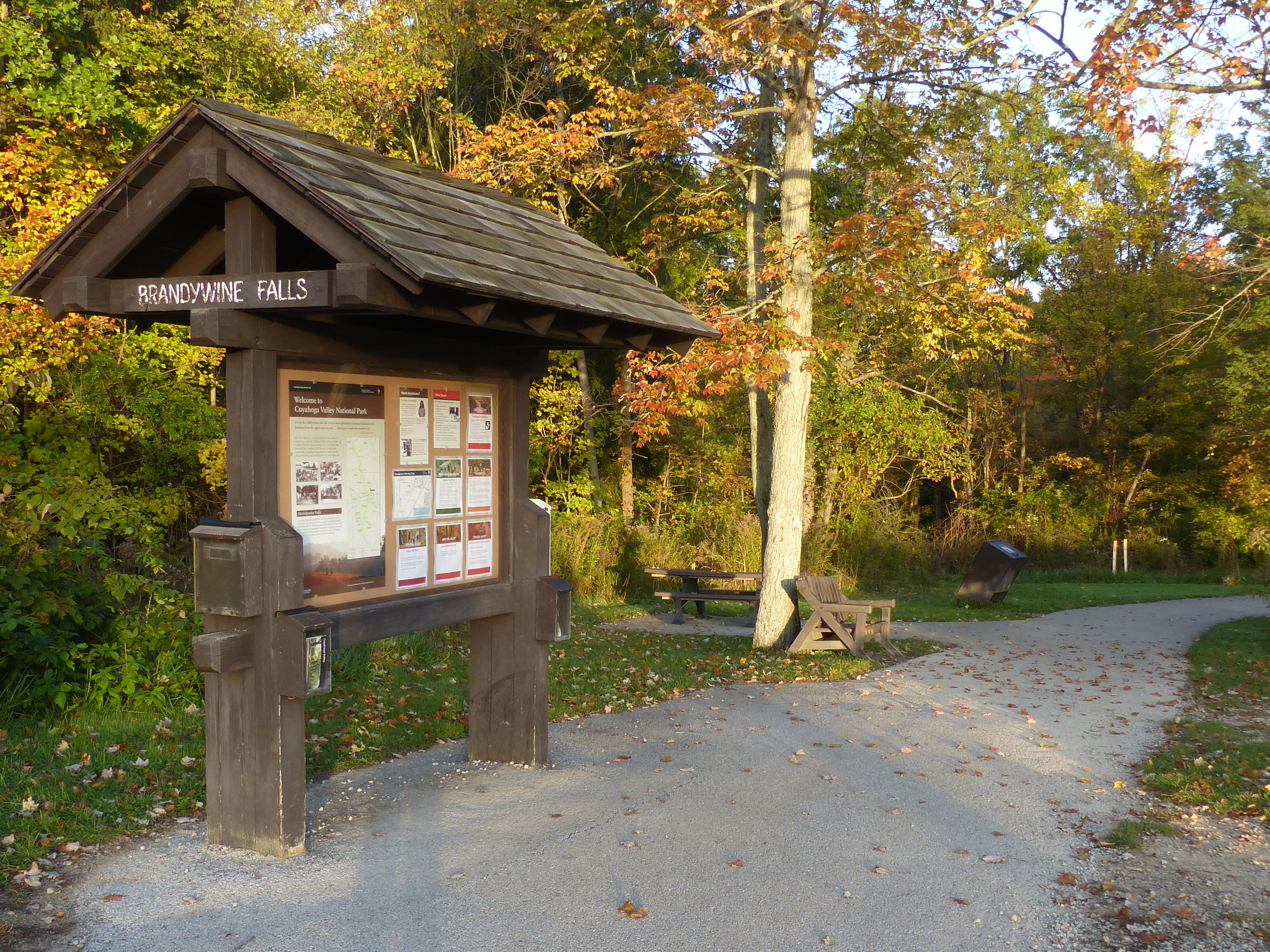
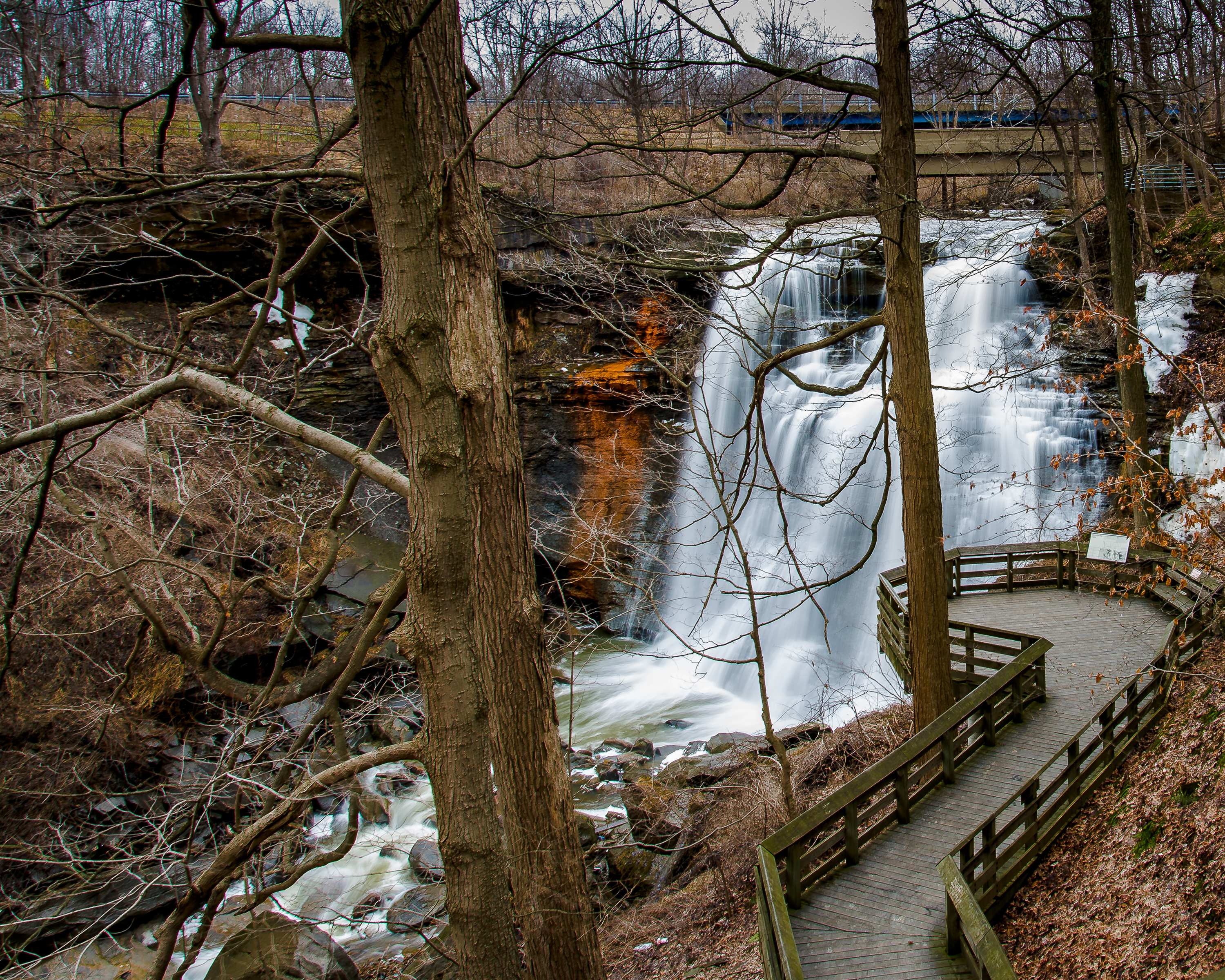
Explore the power and beauty of the 60-foot Brandywine Falls from this location. Extend your visit by walking the 1.4-mile Brandywine Gorge Loop or 1.5-mile Stanford Trail. The trailhead also provides access to Summit Metro Parks’ Bike & Hike Trail.
Brandywine Falls Trailhead. 246 words Here at the end of the parking lot is a covered kiosk with a bulletin board and a graphic panel. As you face the kiosk, the trail to the falls leads off to the right through the woods. A few yards down the trail are a bench and a picnic table. To the left of the kiosk is a building with restrooms. To the left of that is another kiosk with information on recreational opportunities in nearby metro parks. The graphic panel on the kiosk is titled “Welcome to Cuyahoga Valley National Park” and features a map of the park stretching along the Cuyahoga River with your current location near the middle of the park indicated. Text on the panel reads, “Since the 1800s, the Cuyahoga Valley has been a place where people from nearby cities relax in nature. Building on this tradition, locals worked tirelessly to preserve what is now Cuyahoga Valley National Park. Created in 1974, the park protects open countryside, a canal that helped build the nation, and the river that sparked the Clean Water Act. “Brandywine Falls. In the early 1800s, the power of Brandywine Falls was harnessed to drive grist, saw, and woolen mills. It supported a thriving industrial village. From the 1920s through the early 1940s, the gorgeous scenery attracted a progressive artists’ community. The power and beauty of the cascading waters continue to speak to us today. How is water part of your life?” End of description.
Brecksville Station is a flag stop for Cuyahoga Valley Scenic Railroad. It is located at Station Road Bridge Trailhead, which offers ample parking. Passengers can get on and off the train as part of combination trail-train adventure. The train provides a one-way shuttle service for bicyclists, runners, hikers, and paddlers using the Towpath, Buckeye, or Cuyahoga River Water trails.
Brecksville Station. 487 words The rail station is a rectangular covered platform with restrooms at one end and a wall at the other. Posts along each side support the shingled roof. Wooden benches fill the space between the restrooms and the wall. The 20-foot-wide floor is made of wood boards and the structure is painted a creamy yellow. The railroad tracks run in front of the station with no guardrail. On the far side of the tracks is a parking lot. Graphic panels are hung on the inside. Between the restrooms is a panel titled “Ride the Rails” which explains that the first steam engine in the valley began running in 1880 connecting the mineral fields in the south to the factories in the north. Today the Cuyahoga Valley Scenic Railroad follows much of the same route. Yellow paint on a station signifies a modern building. Historical depots are painted red. The panel shows a map of the rail line through Cuyahoga Valley National Park, stretching from Rockside Station at the northern end to the Akron Northside Station at the southern end. The railroad and the Towpath Trail both follow the Cuyahoga River through the park. At the same end of the station is a glass-covered bulletin board with current information about the train and the park. A water station is also on the wall here. The wall at the other end has two graphic panels. One is titled “The Lure of the Countryside.” At upper right it has a black and white photograph of houses and buildings with the Cleveland Rolling Mills factory in the background. Smoke rises from a forest of chimneys. Beneath that is another photograph, this one showing a group of over a dozen people standing in front of the Boston train station, the men in suits and the women wearing long dresses, all wearing hats. Text on the panel reads in part, “Clutter, noise, and grime. America’s cities in the late 19th century were less than ideal living spaces. Many inhabitants resided in crowded neighborhoods near the billowing smokestacks of giant industries. The pace of life seemed increasingly frenetic in a metropolis like Cleveland, the 11th largest U.S. city in 1880. In many of America’s urban areas, a natural respite from modern life materialized with rail travel through pastoral lands… Along the Valley Railway, riders could enjoy long stretches of rural scenes between the cities of Cleveland, Akron, and Canton.” The other panel is titled “A Travel Guide for the Valley” with a 1920s photograph of the Brecksville Depot and an image of the first page of the ‘Guidebook for the Tourist and Traveler over the Valley Railway!’ Text on the panel explains that John Reese of Canton published the 1880 paperback guide with a ‘complete description of the scenery and objects of interest along the road.’ The guide sold for 25 cents. Today’s Cuyahoga Valley Scenic Railroad follows the same route. End of description.
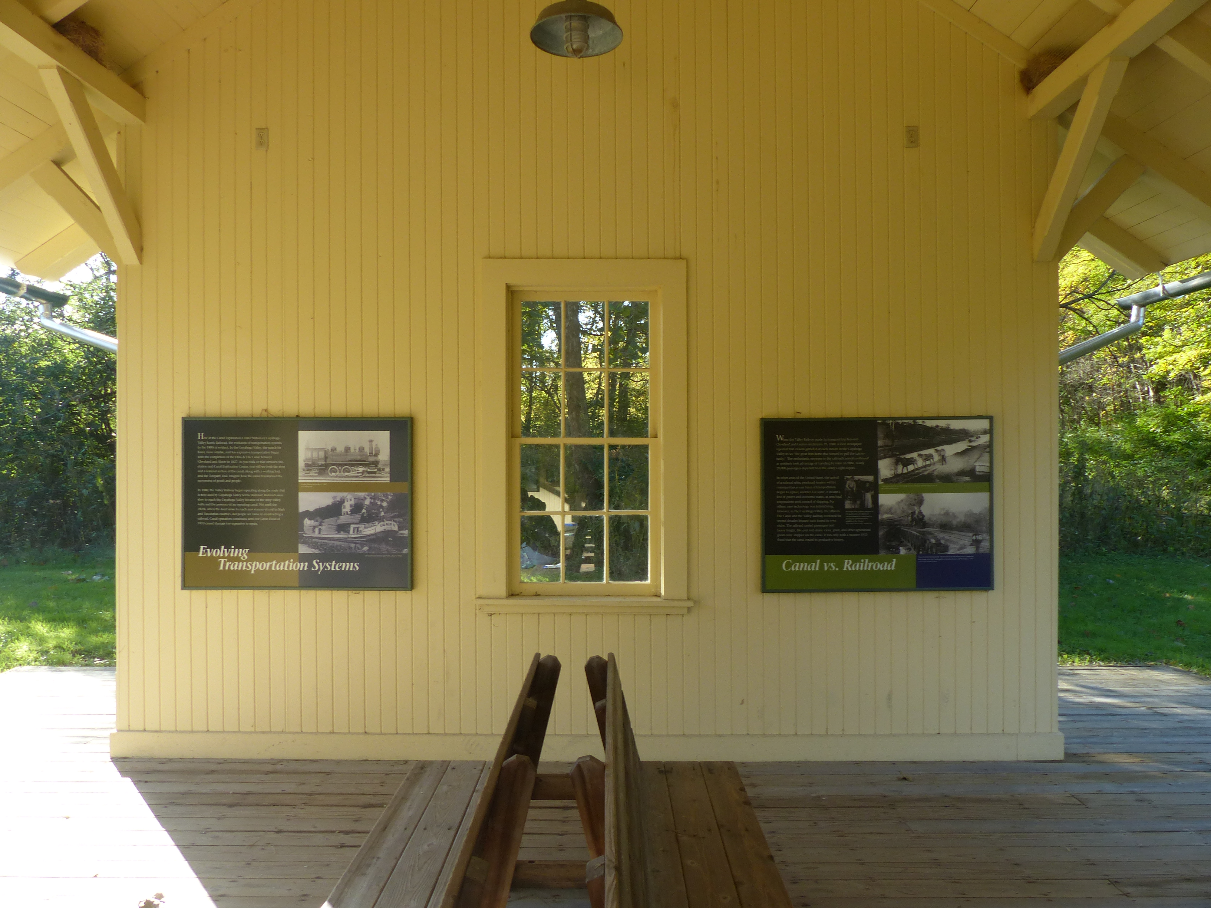
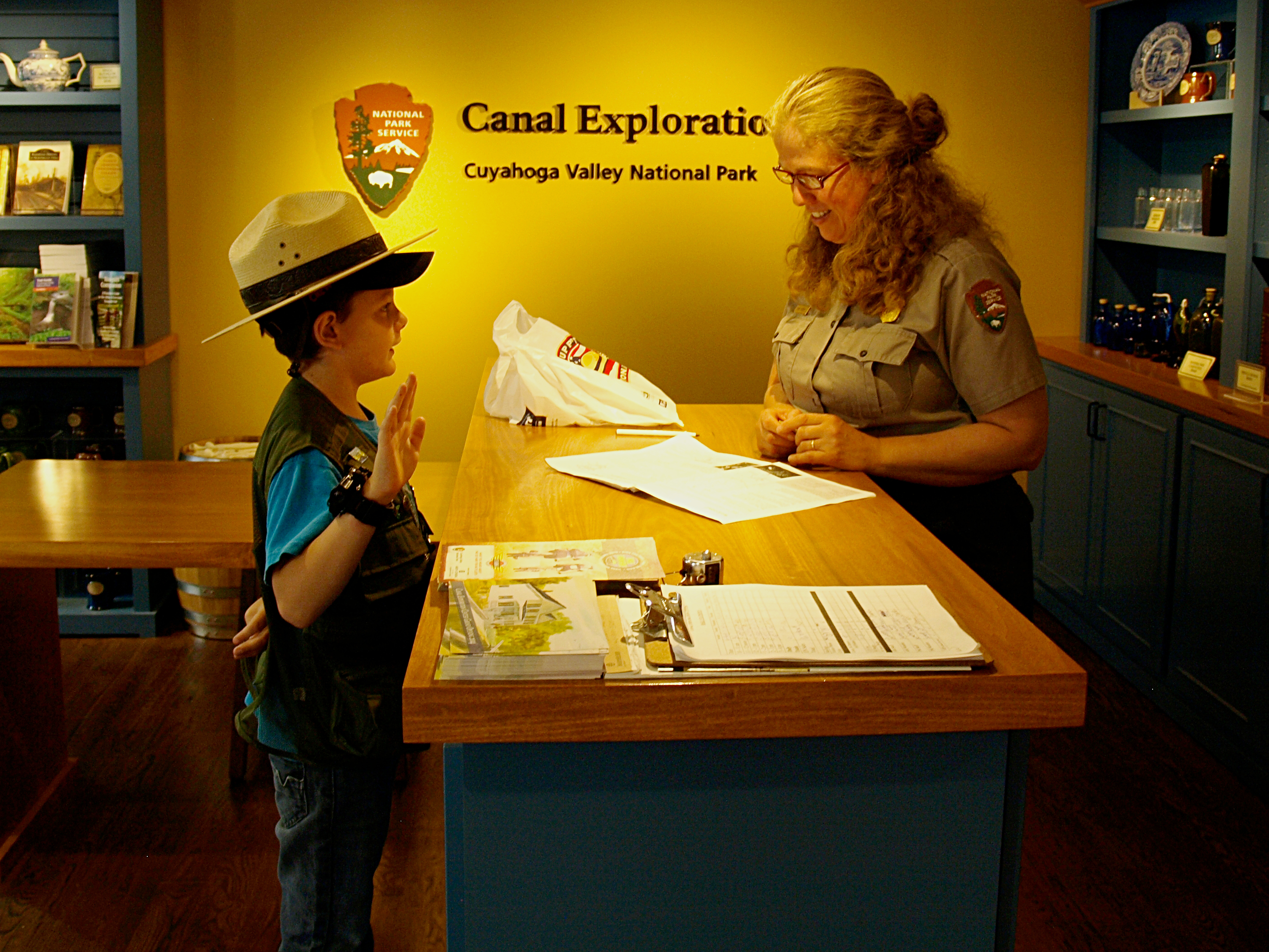
Passengers riding Cuyahoga Valley Scenic Railroad can get on and off to visit Canal Exploration Center and travel along the Towpath Trail.
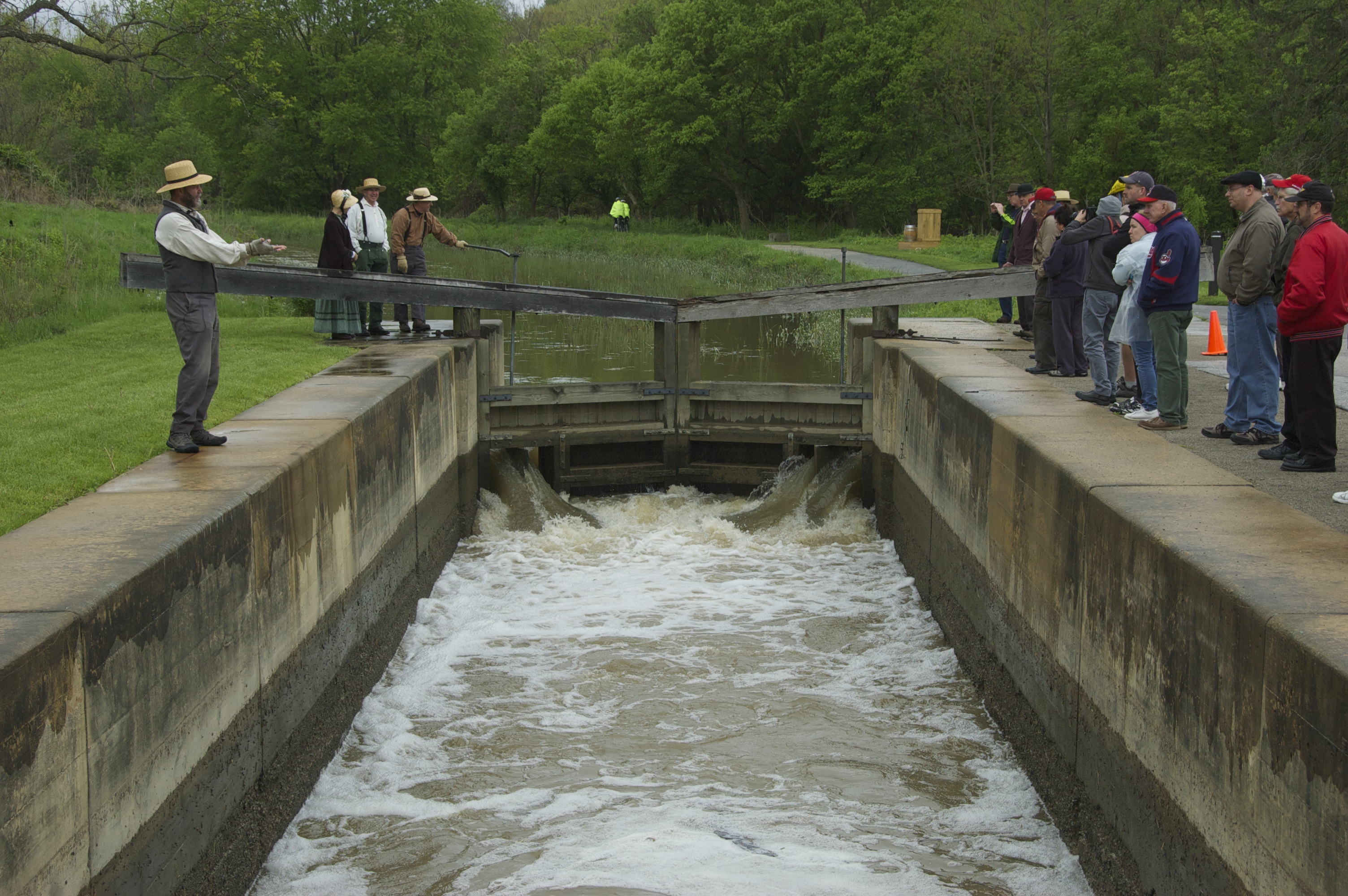
Canal Exploration Center Station. 465 words The rail station is a long, rectangular covered platform with a wall at each end. Posts along each side support the shingled roof. Wooden benches are in the middle. The 20-foot-wide floor is made of wood boards and the structure is painted a creamy yellow. A grassy area surrounds the structure. On one side an asphalt pathway leads to the parking lot next to the Canal Exploration Center. The tracks are on the other side with a separate wooden platform. Graphic panels are hung on the inside of the end walls. At one end is a panel titled “Ride the Rails” which explains that the first steam engine in the valley began running in 1880. Yellow paint on a station signifies a modern building. Historical depots are painted red. The panel shows a map of the rail line through Cuyahoga Valley National Park, stretching from Rockside Station at the northern end to the Akron Northside Station at the southern end. The railroad and the Towpath Trail both follow the Cuyahoga River through the park. Your current location is at the second-most northern station. Nearby is a bulletin board case with current news. The wall at the other end has two graphic panels. One is titled “Evolving Transportation Systems.” It has black-and-white photographs of a steam locomotive and of a canal boat. Text on the panel explains that the evolution of transportation systems in the 1800s is evident here at the Canal Exploration Center Station. As you walk between this station and the Canal Exploration Center, you will see both the river and a watered-filled section of the canal with a working lock and a towpath. Railroads were slow to reach the valley because of the steep valley walls. Not until the 1870s and the need to reach new sources of coal farther south did people see the value in constructing a railroad. Canal operations continued until the Great Flood of 1913 caused damage too expensive to repair. The other panel is titled “Canal versus Railroad.” Text on the panel states that the Valley Railway made its inaugural trip on January 28, 1880 to an enthusiastic response. It explains that in other areas of the country the arrival of a railroad often produced tensions as one mode of transportation replaced another. However, in the valley, both modes found a niche that only ended when the 1913 flood ended canal operations. At top right is a black and white photograph of a canal boat being pulled by a three-mule team. The boats could only travel as fast as the mules pulling them. Below that is a 1910 photograph of a passenger train steaming over the Cuyahoga River between Boston and Peninsula. Travel time greatly decreased with the arrival of the railroad. End of description.
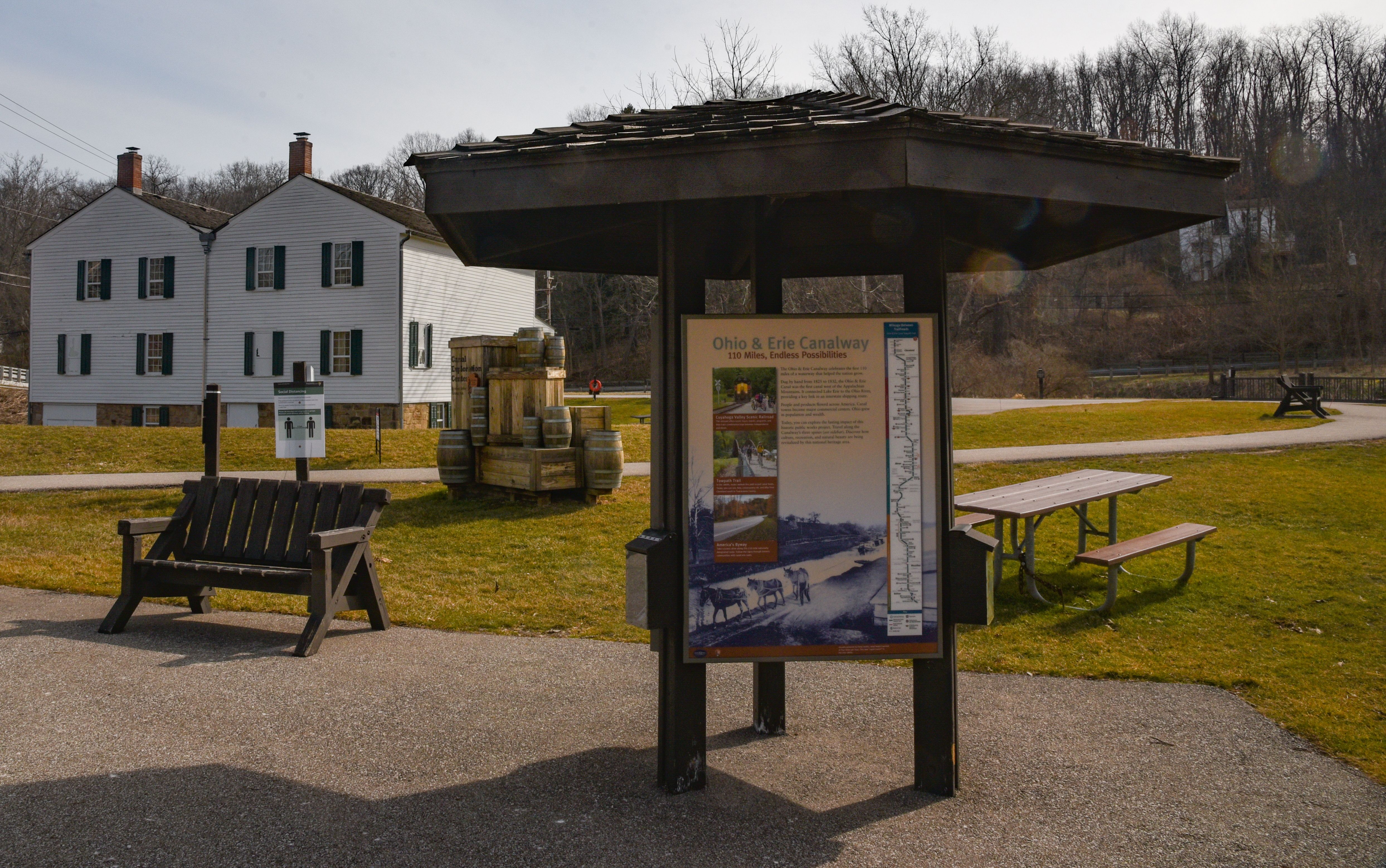
Stop by this information kiosk to learn what there is to do in the area around Canal Exploration Center.
Canal Exploration Center kiosk. 434 words A three-sided, covered kiosk with a bulletin board and two graphic panels sits at the edge of the parking lot. A paved path at the right side of the parking lot leads over the river to a rail station. Behind the kiosk as you face the parking lot other paths lead to the canal and the Canal Exploration Center. Restrooms are in a small structure to the left of the parking lot. One of the graphic panels is titled “Welcome to Cuyahoga Valley National Park” and features a map of the park stretching along the Cuyahoga River with your current location near the northern end of the park marked. Text on the panel reads, “Since the 1800s, the Cuyahoga Valley has been a place where people from nearby cities relax in nature. Building on this tradition, locals worked tirelessly to preserve what is now Cuyahoga Valley National Park. Created in 1974, the park protects open countryside, a canal that helped build the nation, and the river that sparked the Clean Water Act. “Canal Exploration Center Trailhead. Enjoy visitor center exhibits about Ohio’s canal system and its impact on America. This area includes one of the few watered sections of the canal. See a lock demonstration on summer weekends. Walk south on the towpath to see more of this national historic landmark. Take a three-mile round-trip past Gleason Farm and Tinkers Creek Aqueduct. Turn around at Wilson/Alexander Mill or go a little farther to Frazee House.” The third side has a panel titled “Ohio and Erie Canalway” with a large black and white photograph of three mules pulling a canal boat on the canal. Smaller photographs show the Cuyahoga Valley Scenic Railroad, a group of children riding bicycles on the towpath and the scenic byway that winds through the valley. A long map down the right side shows mileage between trailheads on the Towpath Trail. Text on the panel reads, “The Ohio and Erie Canalway celebrates the first 110 miles of a waterway that helped the nation grow. Dug by hand from 1825 to 1832, the Ohio and Erie Canal was the first canal west of the Appalachian Mountains. It connected Lake Erie to the Ohio River, providing a key link in an interstate shipping route. People and products flowed across America. Canal towns became major commercial centers. Ohio grew in population and wealth. Today you can explore the lasting impact of this historic public works project. Travel along the Canalway’s three spines. Discover how culture, recreation and natural scenic beauty are being revitalized by this national heritage area.” End of description.
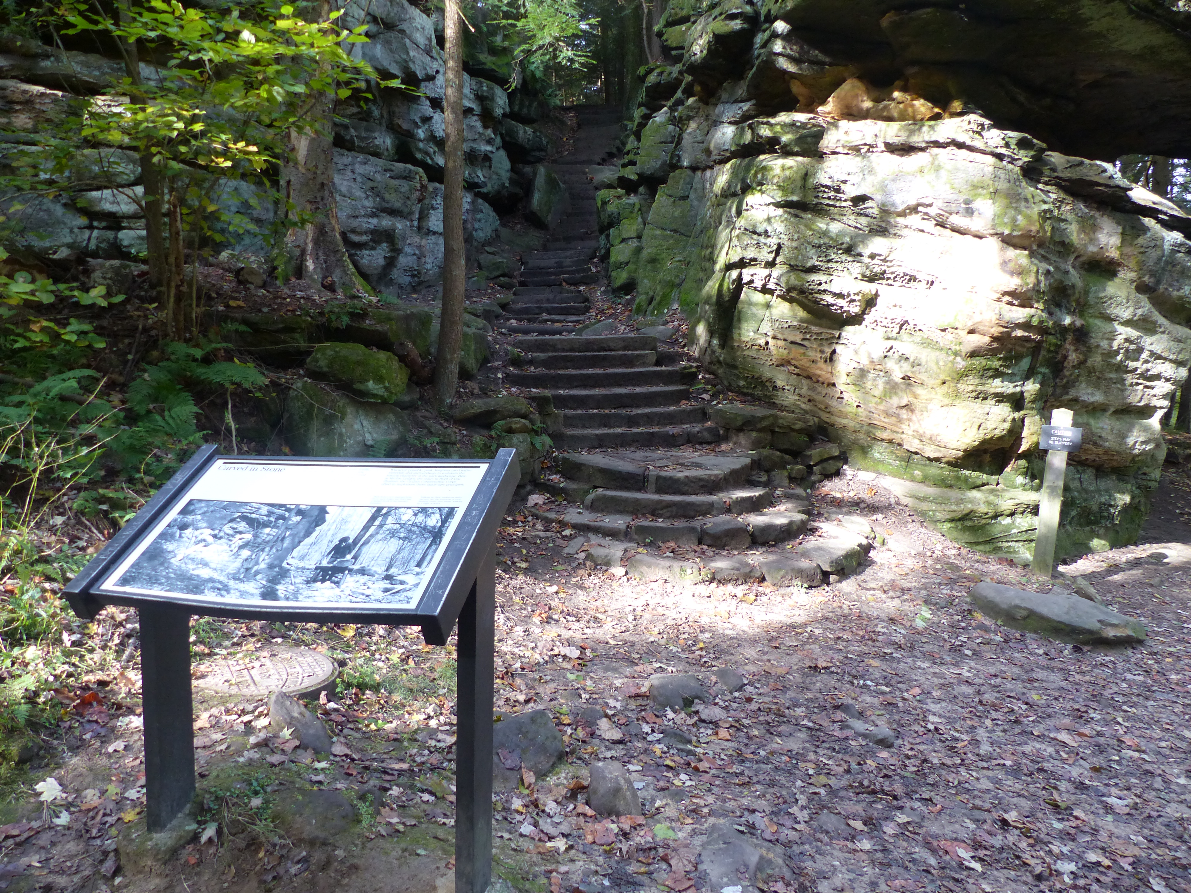
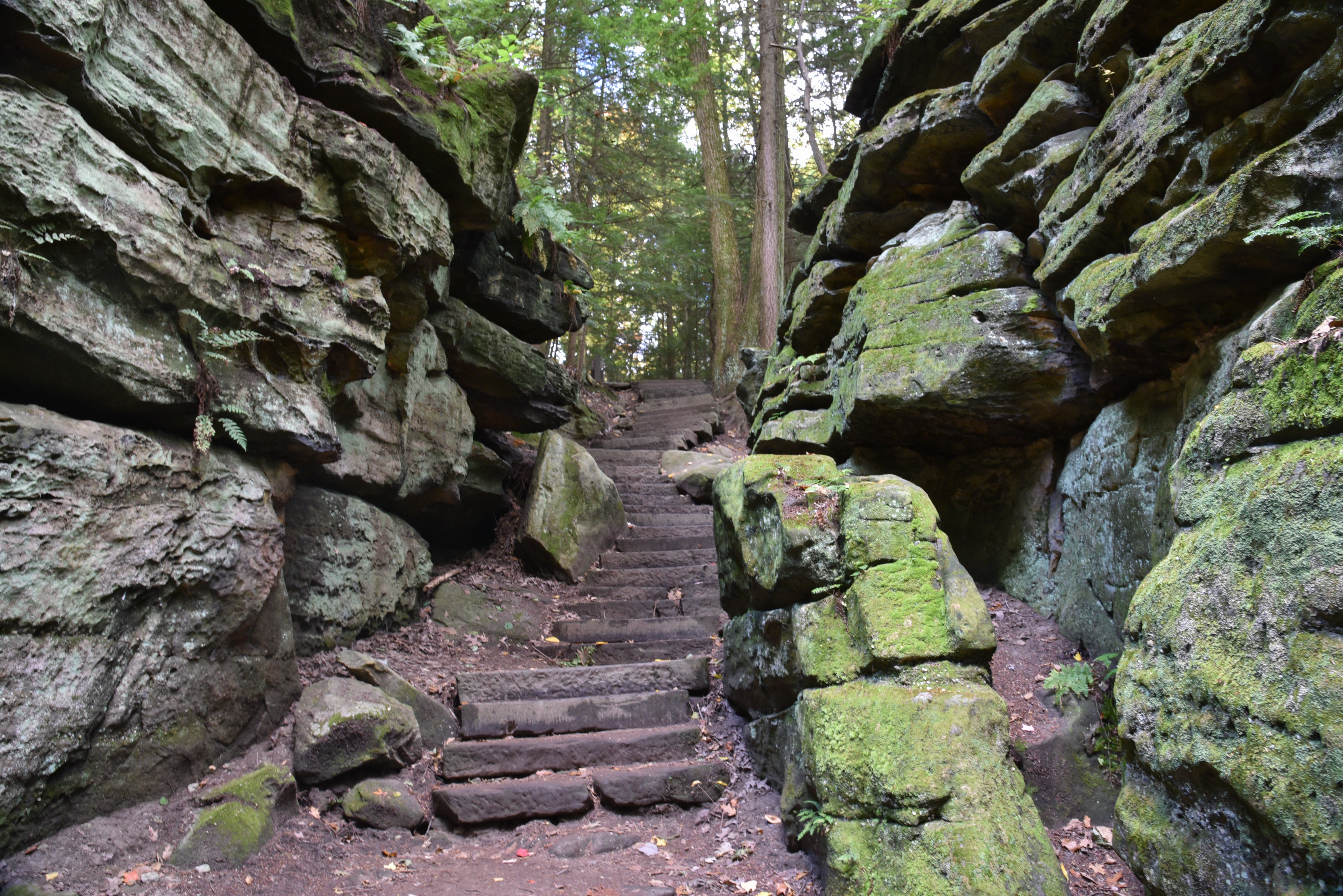
These stairs blend well into the Ledges rock. The National Park Service has long credited the Civilian Conservation Corps (CCC) as their builder. The CCC famously used local resources in ways that fit in the landscape. New evidence suggests stairs existed prior to the CCC. The Plain Dealer published an article about the Ledges in 1906 with a photo of very similar stairs. Mr. Thompson owned a nearby farm. Future research might answer whether he built the original stairs.
Carved in Stone. 297 words This wayside graphic panel faces the bottom of a set of stairs that has been built and carved into a cleft in the rocky cliffs on this side of the trail. To either side the trail continues to wind along the base of the rock, which have been eroded into a variety of shapes. Some areas are undercut, with ledges looming up above. Other places look like stacks of flat plates. As you face the panel, behind you the ground falls away in a gentle slope covered with mixed hemlock and deciduous trees. If you climb the stairs, the trail continues on to the Ledges Shelter. At the top of the panel is a quote from a 1910 annual report of the Department of the Interior which reads, “In their construction of roads, trails, buildings and other improvements, particular attention must be devoted always to harmonizing of these improvements with the landscape.” To the right text reads, “Whenever possible, park designers used native materials and surroundings to maintain the natural character of the park landscape. Here at Ritchie Ledges, the stairs in front of you illustrate the Civilian Conservation Corps’ efforts to implement these landscape principles. Stair stones were quarried from these same ledges and fitted into a natural break in this massive formation. Walking up these sandstone stairs can give one the sensation of rock climbing rather than simply walking up a flight of stairs.” The bottom of the panel is filled with a black and white photograph of men working at the base of these cliff formations. At the left, three men are building the lowest steps in the staircase along a projecting rock formation. At right, another man shapes a stone resting on a sawhorse made of thick logs. End of description.
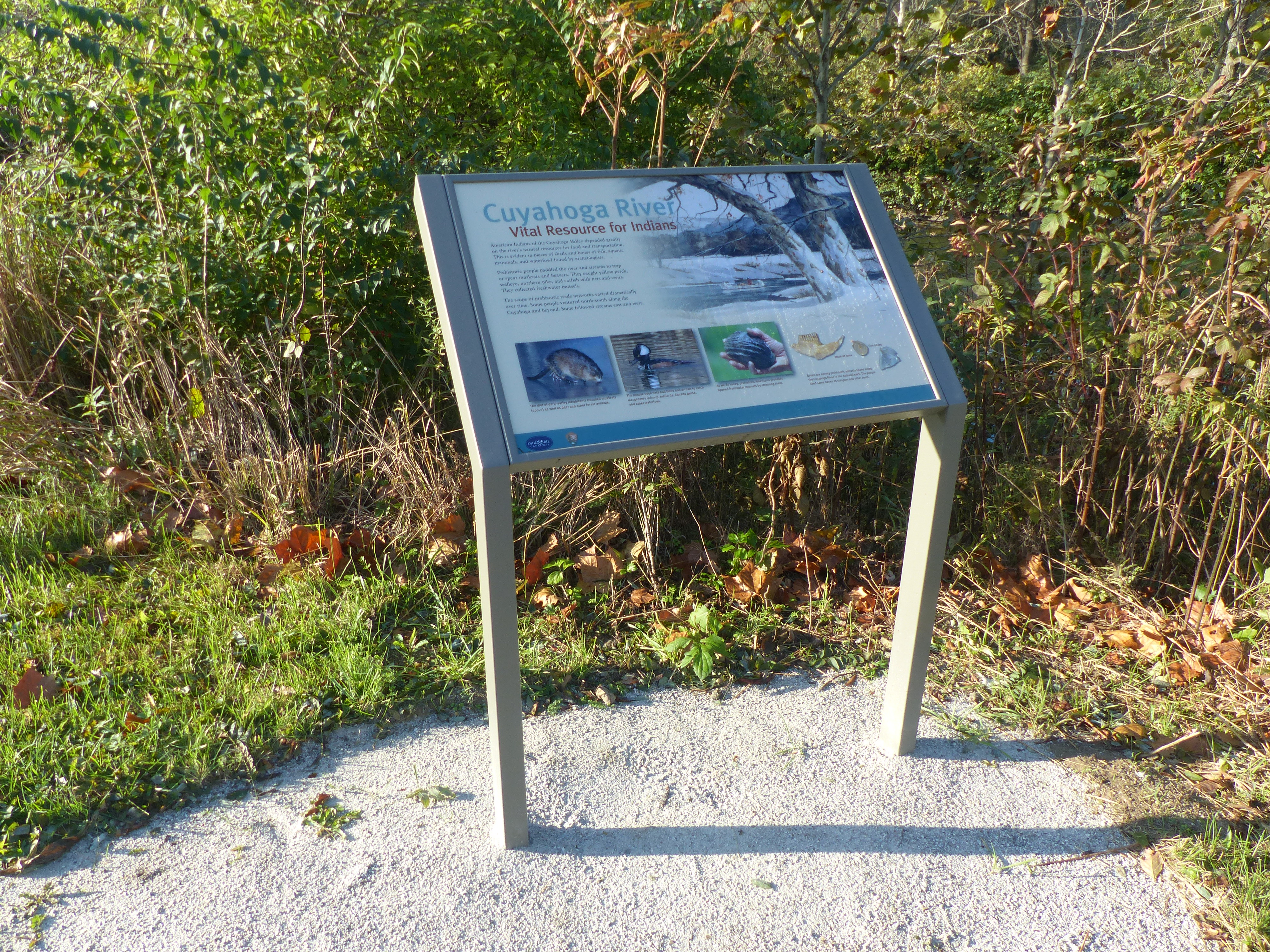
Explore the role the Cuyahoga River played in past Native American societies, both for transportation and as a food source.
Cuyahoga River. 379 words At this point on the towpath, the Cuyahoga River, the canal, and the scenic byway are close together. A graphic panel is on one side of the path with the wide, shallow river beyond, down a low, vegetation-covered bank. On the other side of the path is the water-filled canal. Beyond it is the byway with the sounds of passing traffic. A few yards to the right of the graphic is a cement post marking historic mile 12 on the towpath. The upper right of the panel has an illustration of the river in winter, its banks covered in snow, and a white, bark canoe paddled by an American Indian. Text on the panel reads, “Vital Resources for Indians. American Indians of the Cuyahoga Valley depended greatly on the river’s natural resources for food and transportation. This is evident in pieces of shell and bones of fish, aquatic mammals, and waterfowl found by archeologists. Prehistoric people paddled the river and streams to trap or spear muskrats and beavers. They caught yellow perch, walleye, northern pike, and catfish with nets and weirs. They collected freshwater mussels. The scope of prehistoric trade networks varied dramatically over time. Some people ventured north-south along the Cuyahoga and beyond. Some followed steams east and west.” Along the bottom of the panel are small photographs. At left is a muskrat. The caption reads, “The diet of early valley inhabitants included muskrats as well as deer and other forest mammals.” The next picture shows a merganser, a duck with brown sides, a black head and back, and a bright yellow eye with a white triangle stretching from its eye to the back of its head. The caption reads, “The people used nets and bows and arrows to catch mergansers, mallards, Canada geese and other waterfowl.” The third picture shows a hand holding a large, ribbed, gray shell. The caption reads, “As we do today, prehistoric Americans probably opened freshwater mussels by steaming them.” At bottom right are pictures of a muskrat jawbone with teeth and two types of fish bones, one round and one triangular. The caption reads, “Bones are among prehistoric artifacts found along the Cuyahoga River in the national park. The people used some bones as scrapers and other tools.” End of description.
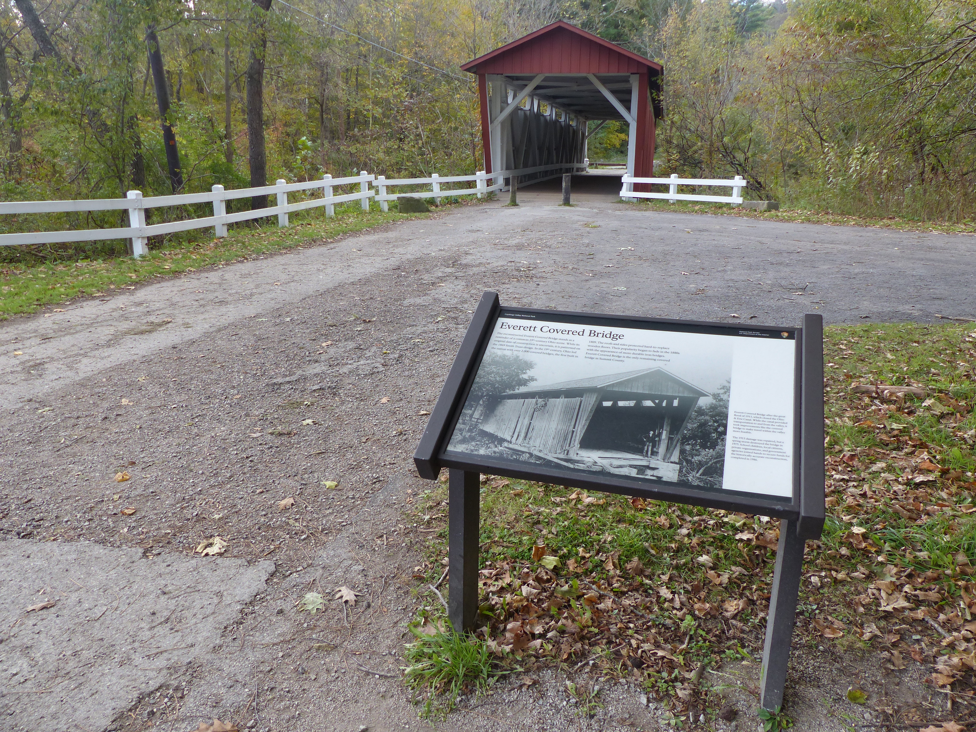
An exhibit here tells the story of once common covered bridges. The Everett Covered Bridge is the last covered bridge remaining in Summit County. Through the years, covered bridges were replaced by iron bridges, much like horses were replaced by iron machines.
Everett Covered Bridge. 302 words As you face this wayside graphic panel, the covered bridge is directly ahead of you. It is painted red with a white interior and white fence on either side of the entrance. Trails lead off to the right of the entrance. Behind you is the paved path back to the parking lot, passing a picnic table and restrooms along the way. Directly to the left of the panel a small unpaved path leads around a clump of trees to more exhibits. Text on the panel reads, “The reconstructed Everett Covered Bridge stands as a reminder of a common 1800s Ohio scene. While its original date of construction is uncertain, it is patterned on the 1869 Smith Truss design. In the 19th century, Ohio led the nation with over 2,000 covered bridges, the first built in 1809. The roof and sides protected hard-to-replace wooden floors. Their popularity began to fade in the 1880s with the appearance of more durable iron bridges. Everett Covered Bridge is the only remaining covered bridge in Summit County.” The bottom of the panel has a photograph of the bridge after the great flood of 1913, which closed the Ohio and Erie Canal. The picture shows the bridge leaning at a slight angle as a man stands at its entrance. A few boards are missing from the side of the bridge and the access leading up to it is gone. The caption reads, “While the canal provided transportation to and from the valley, it took improvements like the covered bridge to make travel within the valley more feasible. The 1913 damage was repaired, but a spring storm destroyed the bridge in 1975. School children, local citizens, private organizations, and government agencies joined hands to secure funds for the historically accurate reconstruction, completed in 1986.” End of description.
For almost a century, the original Everett Covered Bridge provided safe crossing over Furnace Run. Today’s bridge was reconstructed after a 1975 flood. The trailhead provides access to the bridge and nearby trails. The 5.6-mile Riding Run Trail is open to pedestrians and horses. The 1.9-mile Furnace Run Trail is a walking trail popular for viewing spring wildflowers.
Everett Covered Bridge Trailhead. 226 words At the side of the parking lot is a covered kiosk with a bulletin board and a graphic panel. A paved path runs past the kiosk on the right leading past a small building with toilets. The path then leads to the covered bridge and to horse and hiking trails. To the left of the kiosk is a cornfield. The graphic panel on the kiosk is titled “Welcome to Cuyahoga Valley National Park” and features a map of the park stretching along the Cuyahoga River with your current location in the lower third of the park indicated. Text on the panel reads, “Since the 1800s, the Cuyahoga Valley has been a place where people from nearby cities relax in nature. Building on this tradition, locals worked tirelessly to preserve what is now Cuyahoga Valley National Park. Created in 1974, the park protects open countryside, a canal that helped build the nation, and the river that sparked the Clean Water Act. “Everett Covered Bridge. This covered bridge is a reminder of Ohio’s transportation history. The original was built in the late 1870s to carry horses and wagons, and later automobiles, over Furnace Run. It was destroyed by a 1975 flood. The current bridge is an accurate reconstruction, open to foot traffic only. Horseback riders, environmental education students, and photographers visit regularly.” End of description.
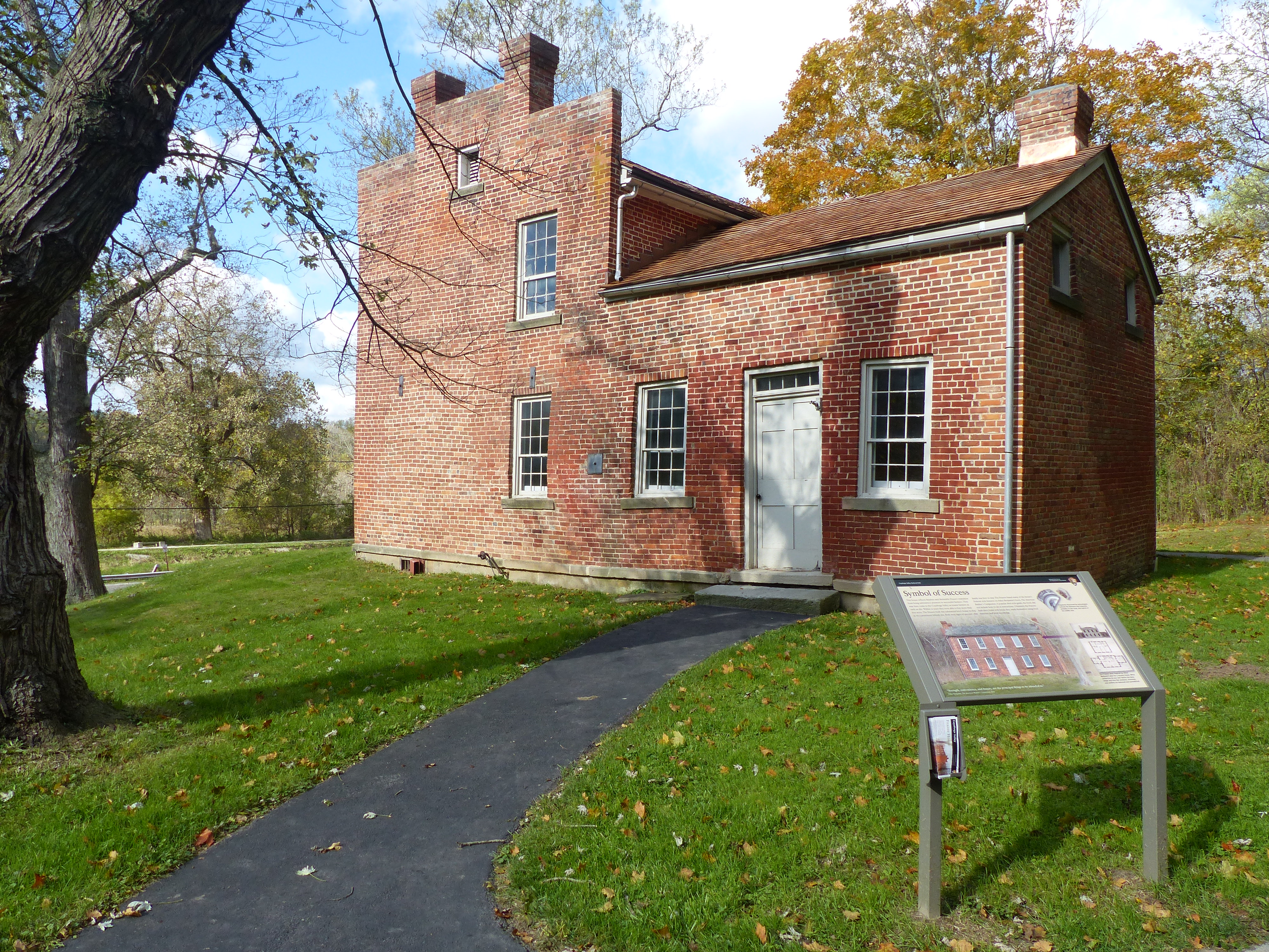
Explore the architecture of the Frazee House. The Frazees were a Western Reserve pioneer family who became successful during the canal era.
Frazee House. 392 words A wayside graphic panel sits at the back, right corner of this red brick house. The house is in the shape of an “L” with the longer front being two stories and the smaller rear wing being one story. The front part has a pair of chimneys at either end. The rear wing has a single chimney at the back. A granite slab forms a step at the door into the back wing. Paved paths lead from the panel to the door and around the back of the house to doors on the other side of the rear wing and into the main house. A parking lot is to the left of the panel. At the back of the parking lot is a small restroom. The graphic panel shows a picture of the house from the front, showing the central door with windows on either side and along the upper story. Text on the panel reads, "Symbol of Success. This house reflects Stephen and Mahitable Frazee’s transition from being subsistence pioneers to successful farmers. They may have come to the Cuyahoga Valley as tenant farmers as early as 1811. Within 10 years they were able to buy more than 600 acres. The Frazees built this substantial brick house in 1825-27 on a prominent hillside site. Both were signs of success – this family was here to stay. The Frazees based many of the house’s Federal-style features on Asher Benjamin’s book ‘The American Builder’s Companion.’ A popular 1806 style guide, the book did not include how-to-do-it instructions. Ultimately the Frazees built their home with bricks they made themselves using local materials and local knowledge.” A quote from the book reads, “Strength, convenience, and beauty, are the principal things to be attended to.” At bottom right is a façade and floorplan from the book, showing a plain, rectangular house with small wings at either end. The caption reads, “The Frazees were inspired by Asher Benjamin’s plan for a country house. What similarities do you see? Notice the boxy shape and how the windows, chimneys, and roofline are balanced and symmetrical.” At top right are images of two fragments from dishes, both covered in decorations including flowers and classical-shaped vases. The caption reads, “Fragments discovered by archeologists indicate the dishware was imported, probably on the canal, and typical of the middle class.” End of description.
From the Towpath Trail, gaze across the canal to the Frazee House, built with handmade bricks in 1825-27. It still dominates the landscape, much as it did during the canal era.
Audio Description: Frazee Family. 307 words Across the canal and scenic byway from this wayside graphic panel is a plain, red-brick, two-story house. It has a brown shingled roof with a pair of brick chimneys at each end. A white door sits in the middle of the front with a pair of white-trimmed windows on either side. The upper story has five windows. The canal in front of the panel has water in the bottom and is crossed by a flat wooden bridge at the right. Trees surround a field on the other side of the towpath with a horse trail along the edge of the field. The panel has an illustration of the house from the right side, revealing a one-story wing at the rear with another chimney at the back. The winter scene features snow and bare trees. A man in a jacket and hat carries a bucket at the rear of the house. Text on the panel reads, “Impact of the Canal. Stephen and Mehitable Frazee experienced both the challenges and benefits of the Ohio and Erie Canal. They arrived in this area in the early 1800s, when it was sparsely settled. They lived in a log cabin, cleared forests for farmland, and were mostly self-sufficient. Canal construction in 1825 flooded their fields and destroyed their crops. The family had to buy feed, flour, and seeds for several years. Stephen sued the State of Ohio and won a settlement of $130. The Frazees built the brick farmhouse across the road about the same time the canal opened. The canal provided the Frazees and all the local farmers with an effective means to send their products to market. “Both the house and canal symbolized greater prosperity. What are positive and negative consequences of public works where you live? “Cross the road and explore the Frazee House’s exterior.” End of description.
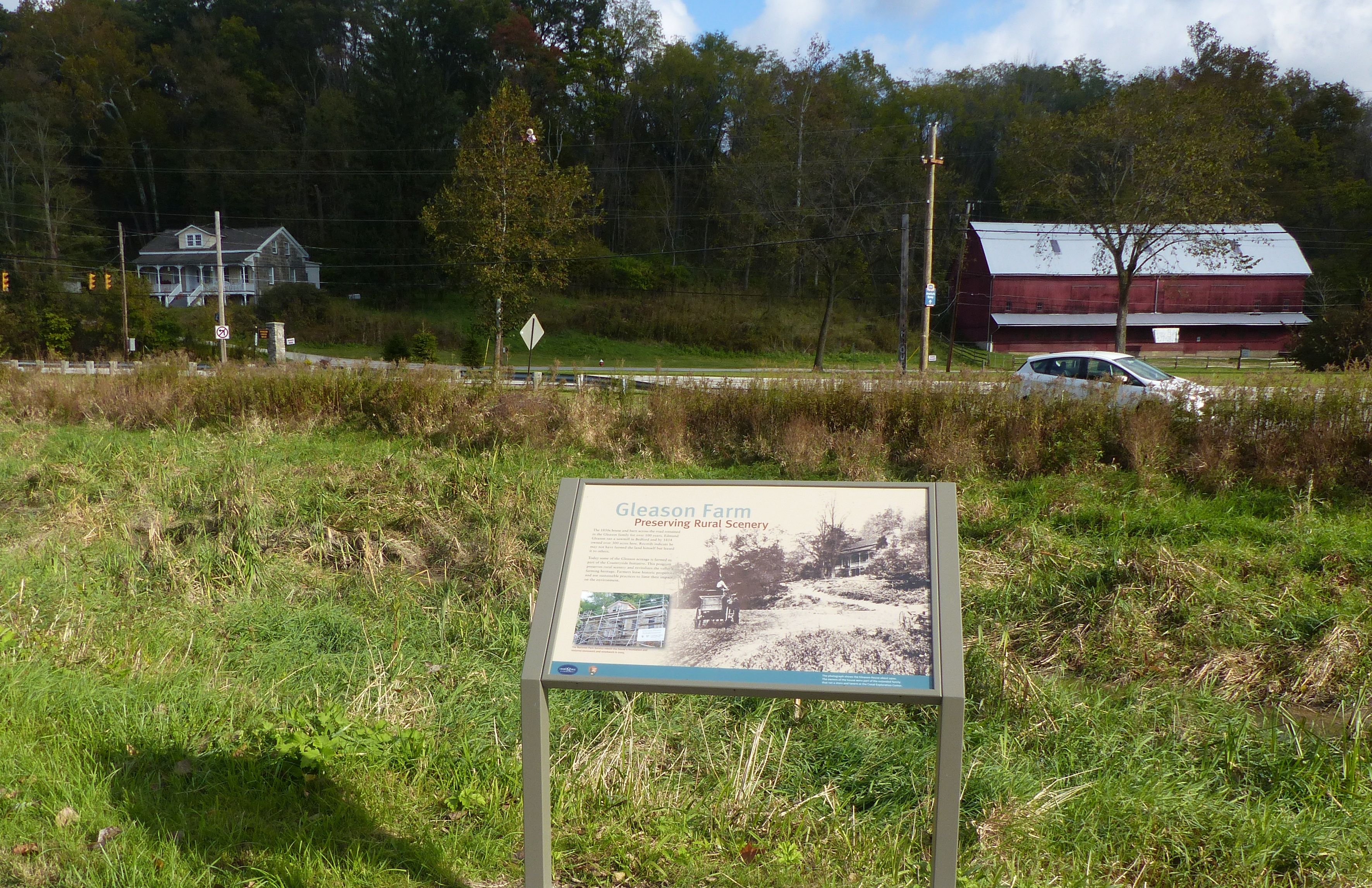
View the historic Gleason Farm as you travel the Towpath Trail. It remains a working farm, part of the park’s Countryside Initiative program.
Gleason Farm. 332 words Here is a wayside panel facing a section of the canal with water in the bottom. On the other side of the canal is the scenic byway. Across the road at the left is a two-story, stone house. The front is painted cream and it has a gray shingled roof. Long porches with white railings extend across the front at both the ground level and along the second floor. Wide steps lead up to the main entrance on the second floor. A dormer window extends from the roof above the front door. To the right of the house along a side road is a long red barn with a metal roof. The other side of the towpath is lined with trees with fields behind. The right side of the graphic panel has a photograph of the Gleason House from around 1900. The house is missing the dormer above the door and it has a chimney at the right end. A tall-sided wagon sits on the sloped, unpaved road in front of the house. The caption explains that the owners of the house were part of the extended family that ran a store and tavern at the Canal Exploration Center. At lower left is a photograph showing the front of the house covered with scaffolding. The caption reads, “The National Park Service rebuilt the house’s foundation and restored stonework and woodwork in 2005.” Text at top left reads, “Preserving Rural Scenery. The 1850s house and barn across the road remained in the Gleason family for over 100 years. Edmund Gleason ran a sawmill in Bedford and by 1854 owned over 300 acres here. Records indicate he may not have farmed the land himself but leased it to others. Today some of the Gleason acreage is farmed as part of the Countryside Initiative. This program preserves rural scenery and revitalizes the valley’s farming heritage. Farmers lease historic properties and use sustainable practices to limit their impact on the environment.” End of description.
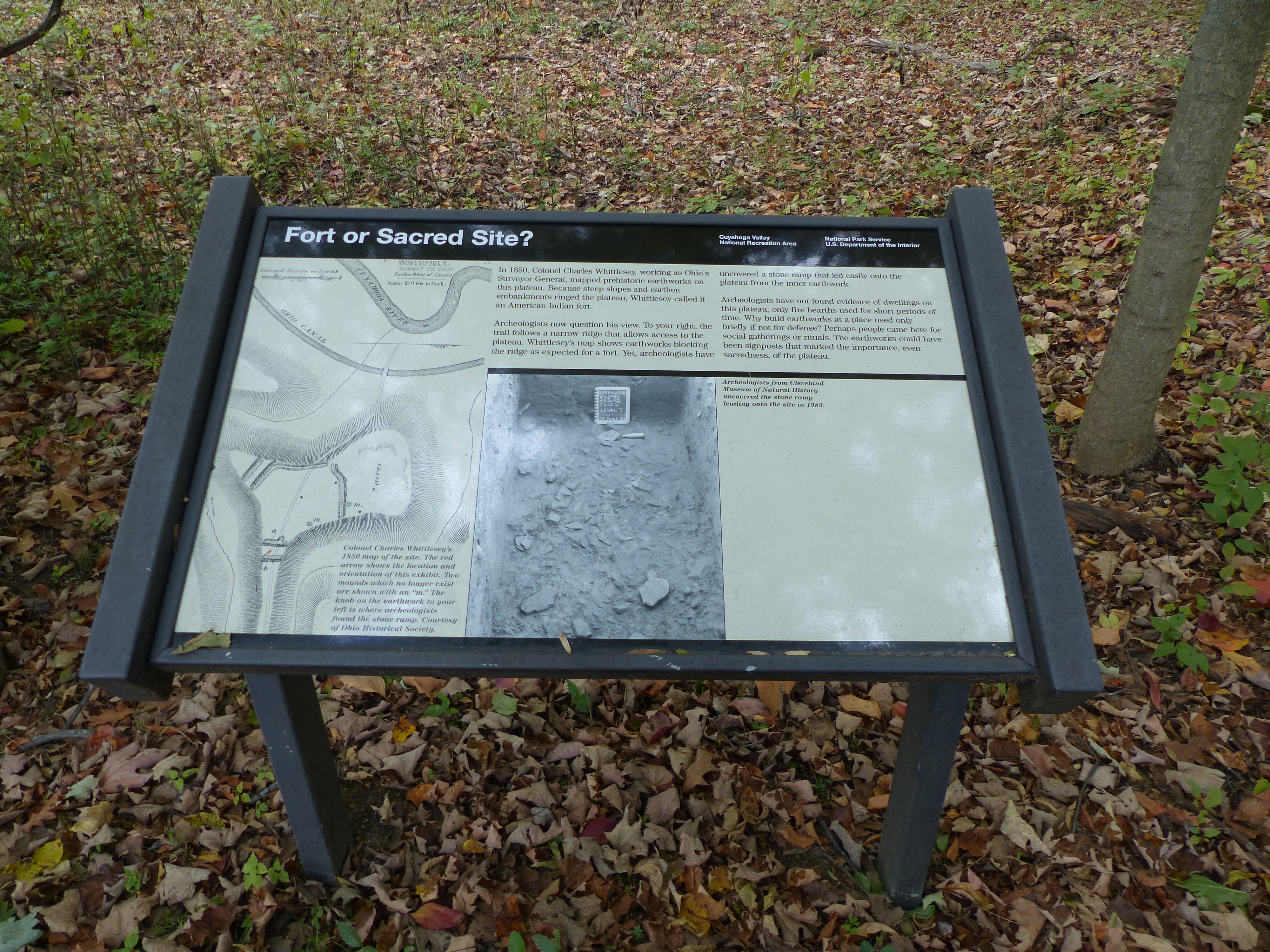
The earthworks near this site were initially considered a fort, but archeologists now consider them to be more of a ceremonial site. Exhibits explain the history of the archeology here and why the purpose has been reconsidered. The area is accessible via the Old Carriage/Bike and Hike Connector Trail, with the Bike and Hike Trail uphill from the connector and the Towpath Trail downhill in the valley from this location.
Fort or Sacred Site? 409 words This wayside graphic panel along this path in a mixed, hardwood forest. As you face the panel, the path to the right passes along a narrow ridge with steep slopes on either side. To the left, the ridge widens to form a small plateau, the path following along the left edge. The woods are open with little underbrush. Text on the panel reads, “In 1850, Charles Whittlesey, working as Ohio’s Surveyor General, mapped prehistoric earthworks on this plateau. Because steep slopes and embankments ringed the plateau, Whittlesey called it an American Indian fort. Archeologists now question his view. To your right, the trail follows a narrow ridge that allows access to the plateau. Whittlesey’s map shows earthworks blocking the ridge as expected for a fort. Yet, archeologists have uncovered a stone ramp that led easily onto the plateau from the inner earthwork. Archeologists have not found evidence of dwellings on this plateau, only fire hearths used for short periods of time. Why build earthworks at a place used only briefly if not for defense? Perhaps people came here for social gatherings or rituals. The earthworks could have been signposts that marked the importance, even sacredness, of the plateau. The bottom right of the panel has a photograph of a steep-sided ditch with small rock in the bottom along with an archeologist’s trowel and a small chalkboard dated 23 June 83. The caption reads, “Archeologists from Cleveland Museum of Natural History uncovered the stone ramp leading onto the site in 1983.” The left side of the panel has an image of Whittlesey’s 1850 map of the site. It features a loop of the Cuyahoga River at the top with the canal running just below. The plateau is in the lower half of the map, shaped like a hatchet, with the blade facing to the right and the handle extending off the bottom of the map. Narrow, closely-spaced lines mark the steep slopes surrounding the plateau. A small red arrow indicates the position of this sign near two sets of earthworks where the handle meets the hatchet blade. One embankment extends down the middle of the plateau. Two small mounds along the bottom of the blade which no longer exist are marked with an “m.” The caption indicates that the knob on the earthwork to your left is where archeologists found the stone ramp. All of the earthworks are worn down and hard to identify. End of description.
Native Americans have left their marks on the land for thousands of years. Explore the earthworks of the Whittlesey Culture along the Old Carriage Trail, here a part of the Bike & Hike Access Trail. Travel up out of the valley, following signs to access the Bike & Hike Trail, or travel downhill to the Towpath Trail.
Prehistoric Earthwork. 338 words This wayside graphic panel sits at a turn in the path along the edge of this small plateau covered with a mixed hardwood forest. The sides of the plateau fall off steeply, particularly to the left as you face the sign. On the other side of the sign, slightly to the right, there are a couple of undulations before the ground falls steeply. Text on the panel reads, “Before you is a low, linear embankment with a shallow ditch behind it. When Colonel Charles Whittlesey recorded it in 1850, a person standing in the ditch could just see over the embankment. When he revisited the site in 1867, Whittlesey noted that farmers’ plows had erased much of what he had seen earlier. You can help protect what remains by staying on the trail. “Archeologists believe that American Indians built this earth work between 500 and 1100 AD during the Early Late Woodland period, a time of major cultural change. The complex burial practices and long-distance trade networks of the Hopewell era had ended. Populations increased, agriculture grew in importance, and people settled into larger, more permanent villages. The people who used this site may have lived and gardened on the fertile lands of the valley floor.” The left side of the panel has an image of Whittlesey’s 1850 map of the site. It features a loop of the Cuyahoga River at the top with the canal running just below. The plateau is in the lower half of the map, shaped like a hatchet, with the blade facing to the right and the handle extending off the bottom of the map. Narrow, closely-spaced lines mark the steep slopes surrounding the plateau. A small red arrow indicates the position of this sign in the upper left corner of the hatchet blade where there are two sets of markings for the embankment and ditch formations. One embankment extends halfway across the top of the hatchet blade where another embankment-ditch formation extends down the middle of the plateau. End of description.
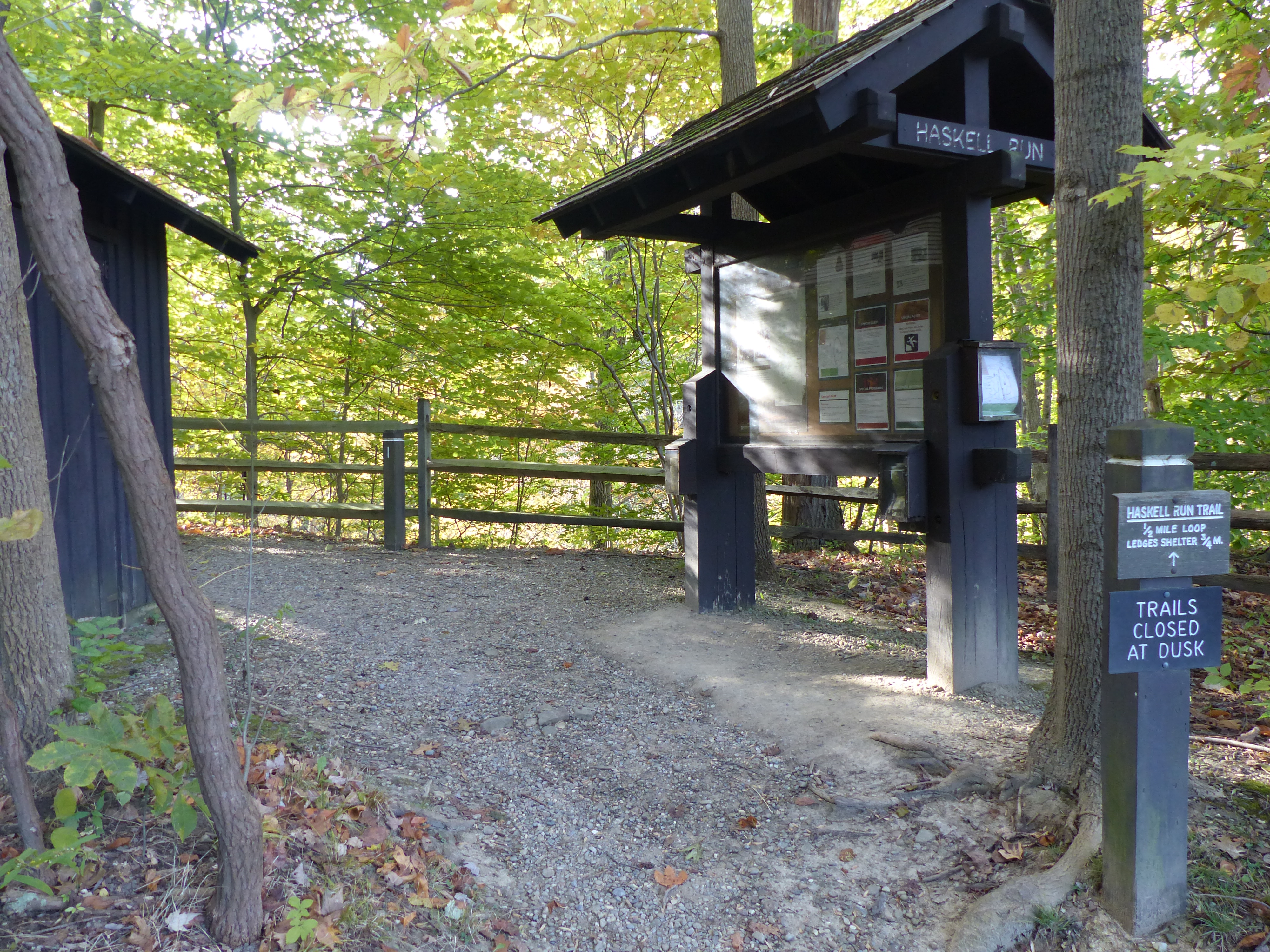
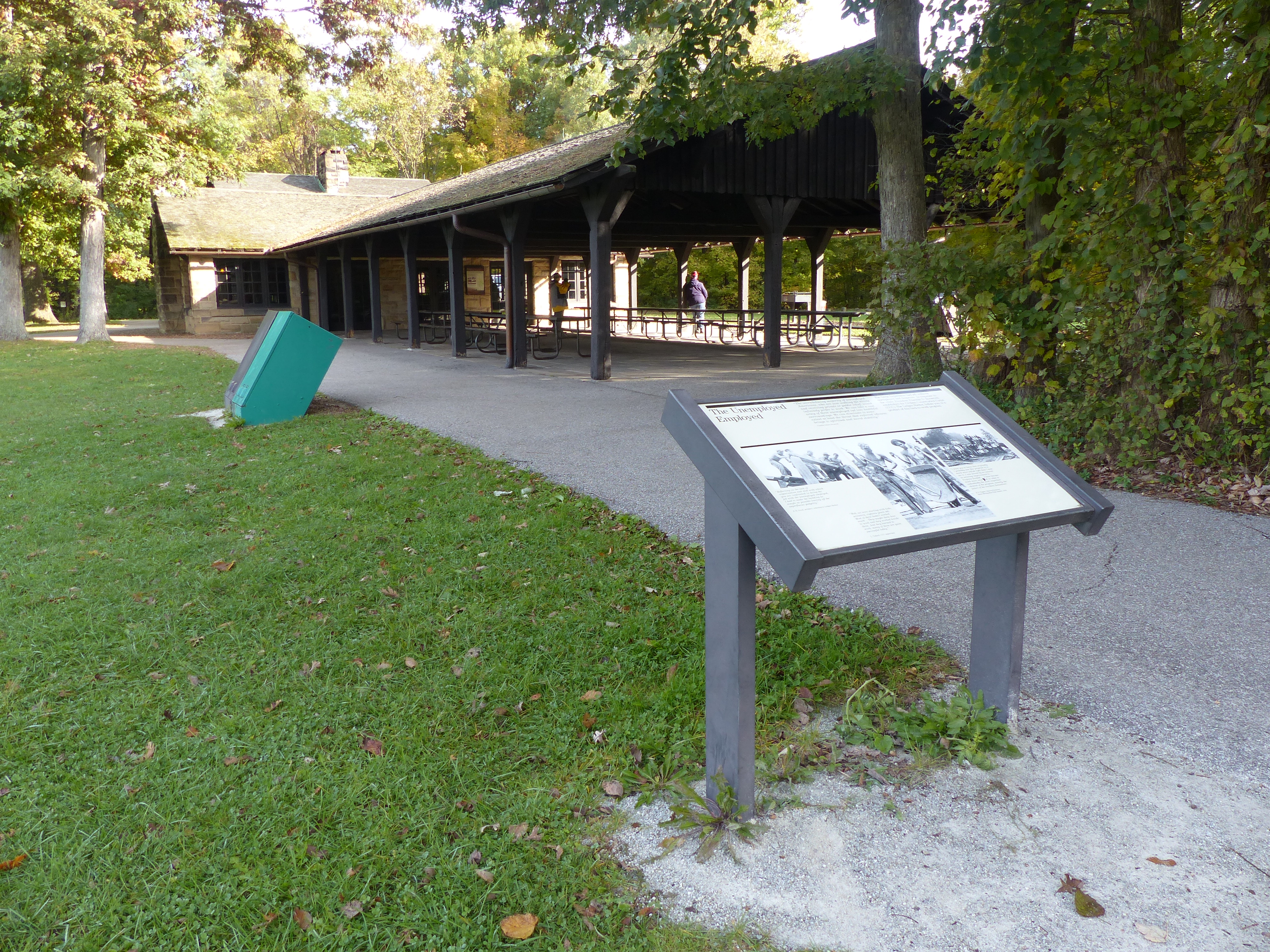
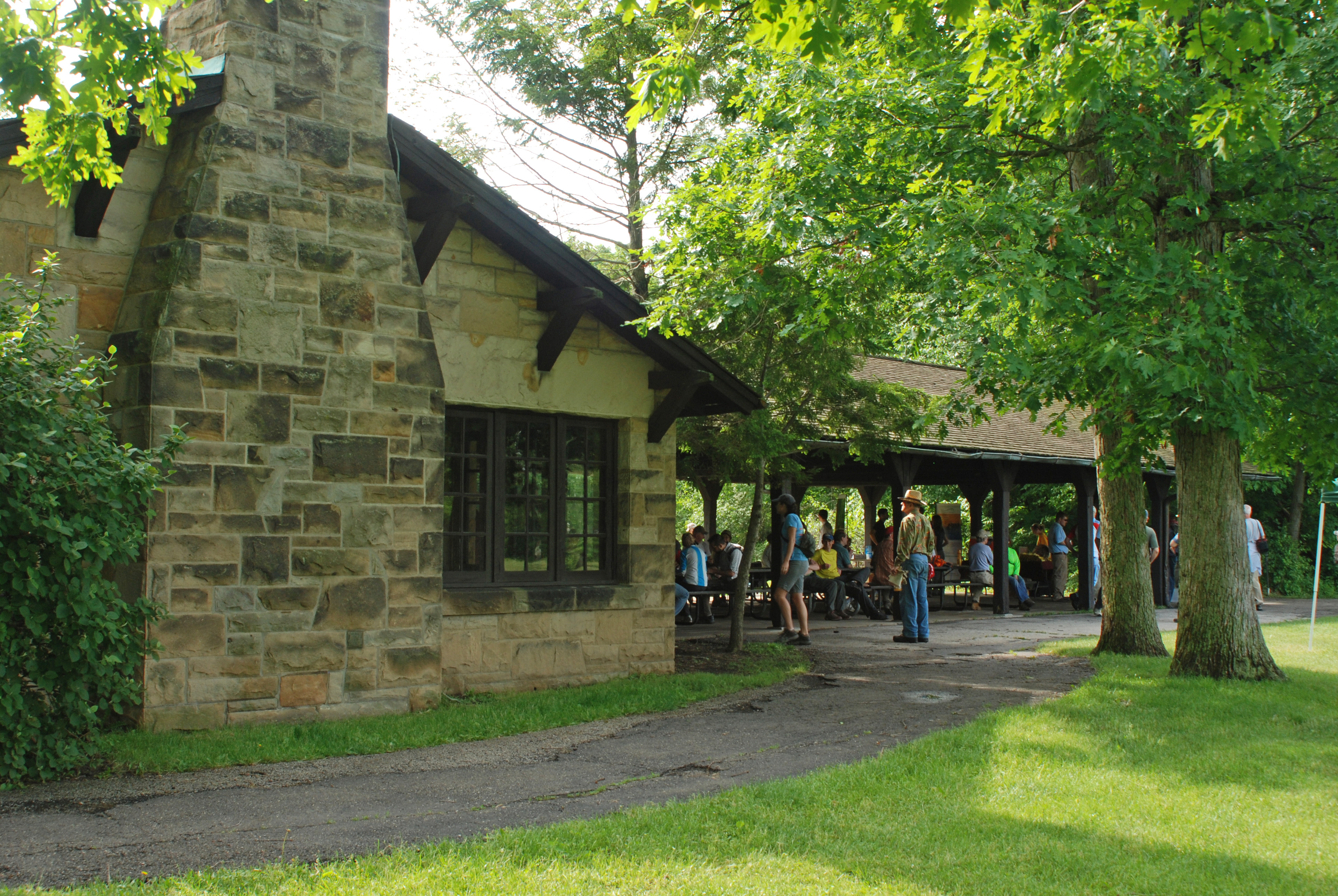
A large sign marks the path to Happy Days Lodge. The Civilian Conservation Corps built Happy Days Lodge during the Great Depression in the 1930s. It was part of their effort to develop park amenities for Virginia Kendall Park, now part of Cuyahoga Valley National Park. Haskell Run Trail starts behind Happy Days Lodge and connects to additional Virginia Kendall Park trails.
Happy Days Historic Sign. 466 words This large sign sits at one end of a parking lot. As you face the sign, a paved path runs to the left and into a tunnel under the road, heading to Happy Days Lodge 200 yards away. To the left of the path is a grassy lawn with a picnic table. Behind you, at the far end of the parking lot, is a covered kiosk with trailhead information. This historic sign is 17 feet wide. The left end is a 6-foot-wide, 7-foot-high stone wall. The right side is a frame made of wooden beams mounted on a stone base, which holds a bulletin board and two graphic panels. Feel free to touch the irregular stonework. The middle panel on the sign is titled “Welcome to Cuyahoga Valley National Park” and features a map of the park stretching along the Cuyahoga River with your current location near the eastern edge of the park indicated. Text on the panel reads, “Since the 1800s, the Cuyahoga Valley has been a place where people from nearby cities relax in nature. Building on this tradition, locals worked tirelessly to preserve what is now Cuyahoga Valley National Park. Created in 1974, the park protects open countryside, a canal that helped build the nation, and the river that sparked the Clean Water Act. “Happy Days Lodge. Happy Days Lodge is a legacy from the difficult years of the Great Depression. Civilian Conservation Corps workers built it as a summer camp for Akron children in 1938-1939. Today it continues to provide recreational opportunities. People can enjoy concerts, participate in programs, or rent the facility for special occasions. The panel at the right end of the sign is titled “Places to Go.” The background of the panel is filled with a photograph of a wide waterfall cascading down a layered rock face. The caption reads, “Brandywine Falls, with its spectacular 60-foot drop, is the park’s most popular destination. It is located northwest of Happy Days Lodge.” Along the bottom of the panel are five smaller photographs. From left to right they show the front of a locomotive from the Cuyahoga Valley Scenic Railroad which provides a relaxing way to tour the valley. Next, a woman bicycles on the Towpath Trail which follows the route of the Ohio and Erie Canal. Next is a three people looking over a railing at the lily pad-covered Beaver Marsh. Next is a picture of the white Canal Exploration Center with exhibits about how the Ohio & Erie Canal shaped the nation. The last photo shows a trail through moss-covered cliffs along the nearby Ledges Trail. Text on the panel recommends stopping by the Boston Mill Visitor Center at 6947 Riverview Road, just north of downtown Peninsula, for assistance in planning your visit. End of description.
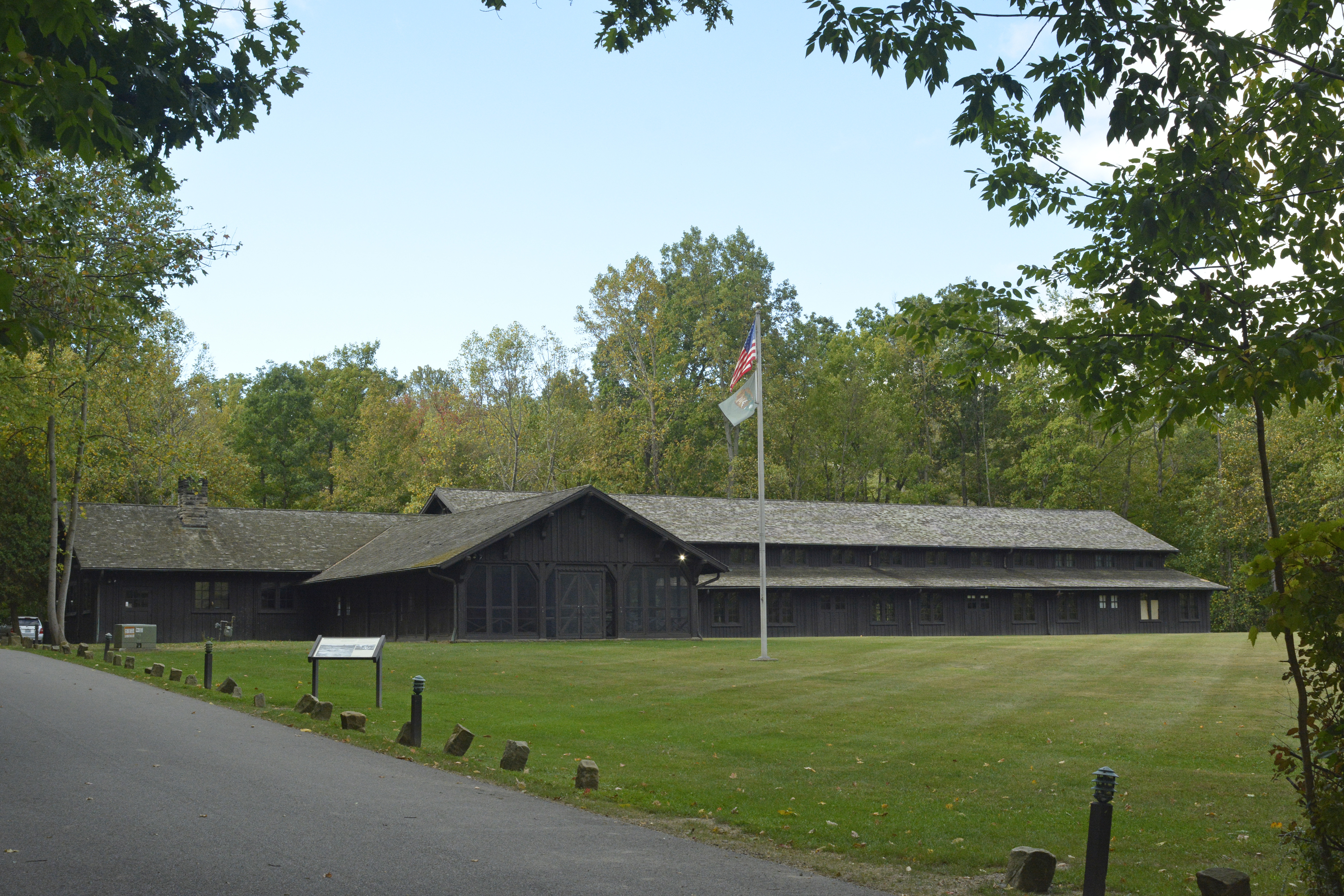
The men of the Civilian Conservation Corps built Happy Days Lodge during the difficult years of the Great Depression. They used manual labor and local materials, including Berea Sandstone and wormy American chestnut. For years, it served as a camp for children from the City of Akron. Today, it is a rental facility and program space managed by the Conservancy for Cuyahoga Valley National Park.
Happy Days Lodge. 378 words This wayside graphic sits on the right side of the paved driveway that leads up and behind the large, brown building with vertical siding. As you face the graphic panel, the lodge sits in front of you with a wide grassy lawn stretching in front of it. The building is a long rectangle stretching across the back of the lawn. A smaller wing forms a screened porch that extends towards you about a third of the way in from the left end. The walls of the wing are covered in large window panels during the colder months. The main building to the right of the wing has a raised roof over the central portion with additional windows under the roof line. There is a flag pole in front of the building. Text at the top of the panel reads, “In December of 1933, Company 576 of the Civilian Conservation Corps, or CCC, took up residence here at Virginia Kendall Park and began an improvement program that lasted nearly 10 years. One of their last efforts was construction of the 11-room Happy Days Camp for children, completed in 1938. The camp’s name came from the ‘Happy Days Are Here Again’ theme song of Franklin D. Roosevelt’s New Deal political platform. The song’s title was given to the children’s day camp as a symbol of hope for Depression-era youth. Now an events facility, Happy Days first served as a dormitory for the summer playground program sponsored by the Akron Board of Education and Recreation Commission.” The lower left of the panel has a large photograph of a building site with piles of dirt and gravel in the foreground and a few men working on foundations in the middle. At upper left triangular roof trusses are set in a line, ready to be lifted into place. The caption reads, “CCC workers built the Happy Days structure with local Berea sandstone and wormy American chestnut. It remains one of the largest wormy chestnut structures in the world.” At the right side of the panel is a smaller photograph of young men sitting and eating at long tables outdoors. The caption reads, “Hundreds of young men lived and worked in the Virginia Kendall barracks from 1933 to 1942.” End of description.
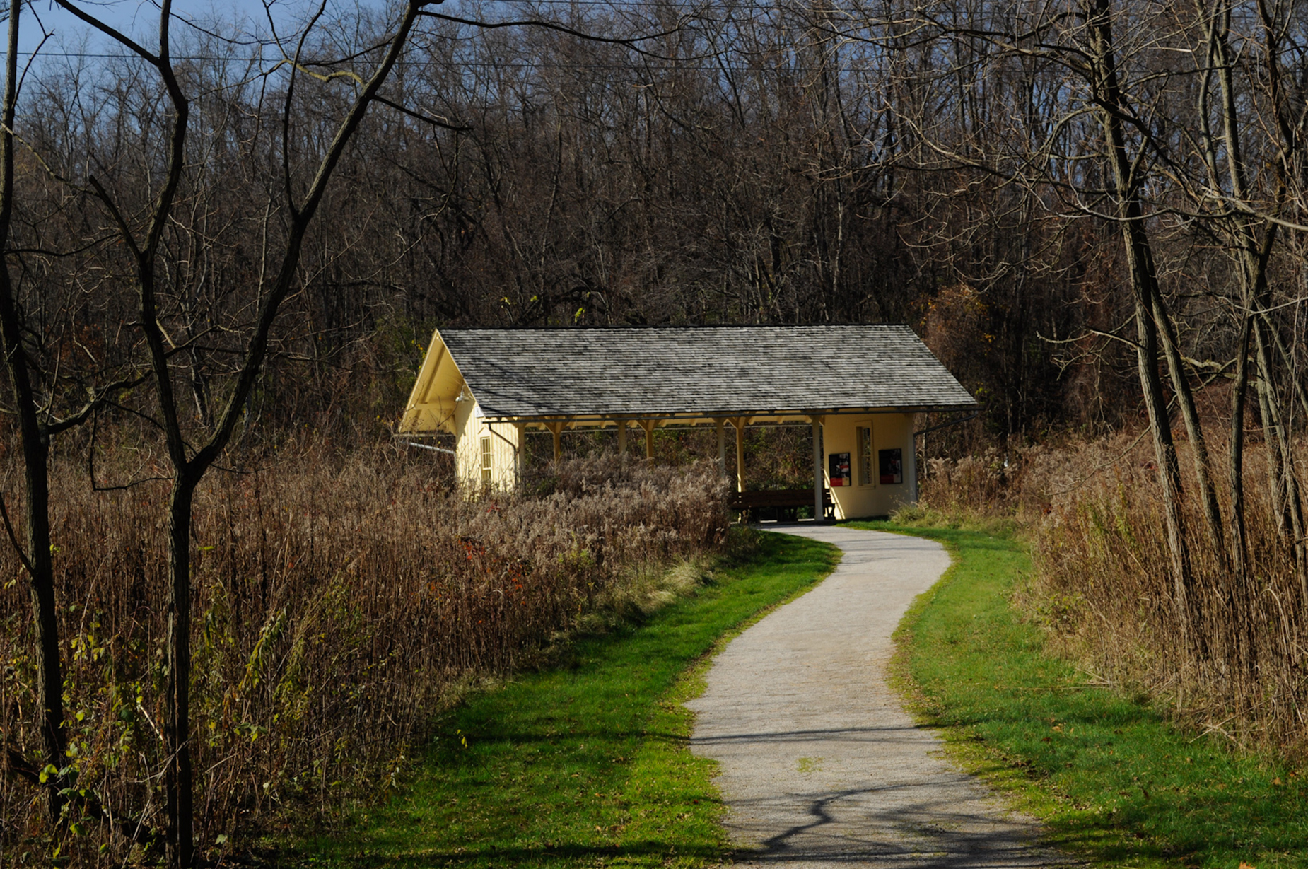
The Haskell Run Trail is a ½-mile loop trail that explores a creek that feeds the Cuyahoga River. The creek’s deep, wooded ravine attracts abundant birdlife. Visit in April and May to enjoy spring wildflowers. The trail also connects Happy Days Lodge with the Ledges area.
Haskell Run Trailhead. 259 words This covered kiosk with a bulletin board and a graphic panel sits at the edge of a parking lot behind Happy Days Lodge. Along the left side of the kiosk a trail curves around a small maintenance shed and heads off into the woods. As you face the kiosk, the parking lot lies to the right with the long, brown building with vertical siding just beyond. In front of the building is a life-size, bronze statue of a workman. He stands, leaning on an axe with his right hand, shirt draped over his left arm. The graphic panel on the kiosk is titled “Welcome to Cuyahoga Valley National Park” and features a map of the park stretching along the Cuyahoga River with your current location near the eastern edge of the park indicated. Text on the panel reads, “Since the 1800s, the Cuyahoga Valley has been a place where people from nearby cities relax in nature. Building on this tradition, locals worked tirelessly to preserve what is now Cuyahoga Valley National Park. Created in 1974, the park protects open countryside, a canal that helped build the nation, and the river that sparked the Clean Water Act. “Haskell Run Trailhead. Here on the Haskell Run Trail, you can revel in the quiet beauty of the streams that feed into the Cuyahoga River. Stop for a moment to look at the lush ravine or listen to the abundant birdlife. This short trail will connect you to the Ledges. Explore its stunning sandstone cliffs and points beyond.” End of description.
The Horseshoe Pond area was once part of the historic Bishop Farm. By the second half of the 1900s, the Bishops were planting and selling Christmas trees. Take the Tree Farm Trail to see how nature is reclaiming these old fields.
Horseshoe Pond Trailhead. 242 words At the side of this small parking lot is a covered kiosk with a bulletin board and a graphic panel. As you face the kiosk, a paved path leads off to the right through woods. To the left of the kiosk is a small building with a toilet. More woods lie on the far side of the road which runs along at the left. The graphic panel on the kiosk is titled “Welcome to Cuyahoga Valley National Park” and features a map of the park stretching along the Cuyahoga River with your current location a bit south of the middle of the park indicated. Text on the panel reads, “Since the 1800s, the Cuyahoga Valley has been a place where people from nearby cities relax in nature. Building on this tradition, locals worked tirelessly to preserve what is now Cuyahoga Valley National Park. Created in 1974, the park protects open countryside, a canal that helped build the nation, and the river that sparked the Clean Water Act. “Horseshoe Pond. The Bishop family farmed this area for decades, raising cattle at first and then switching to Christmas trees by 1955. The old fields and rows of evergreens are gradually returning to nature. The Tree Farm Trail is popular for hiking, cross-country skiing, and birdwatching. Horseshoe Pond, another legacy of the Bishop Farm, is a favorite spot to fish or simply enjoy the changing landscape reflected in the water.” End of description.
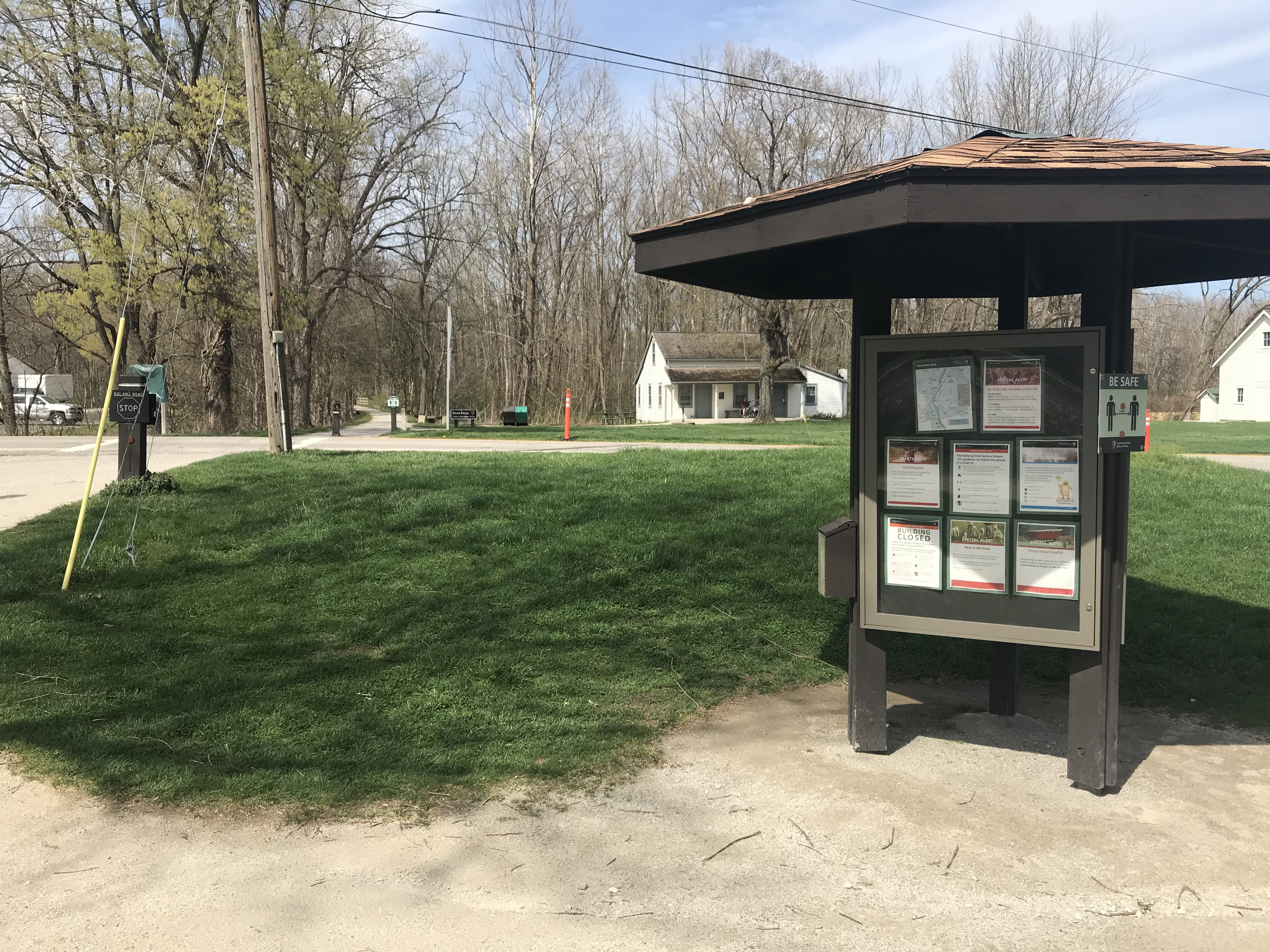
Hunt House is in the Village of Everett, a type of rural crossroads community that was once common across America. Family-friendly exhibits at Hunt House explore village life and the lives of wild plants and animals. From Hunt House continue a quarter mile north to Lock 27 for another peek into the crossroads community. Beaver Marsh, popular for wildlife watching, is three-quarters of a mile south.
Hunt House Trailhead. 437 words A three-sided, covered kiosk with a bulletin board and two graphic panels sits between the Towpath Trail and a paved parking lot. With your back toward the parking lot, the path and the canal bed are in front of you. To the right is Bolanz Road. From here, the towpath crosses the road to go north or you may turn left to continue south. Across the road is the Hunt House where more exhibits are located. To the left of the kiosk is a wooden bench. One of the graphic panels is titled “Welcome to Cuyahoga Valley National Park” and features a map of the park stretching along the Cuyahoga River with your current location at the southern end of the park marked. Text on the panel reads, “Since the 1800s, the Cuyahoga Valley has been a place where people from nearby cities relax in nature. Building on this tradition, locals worked tirelessly to preserve what is now Cuyahoga Valley National Park. Created in 1974, the park protects open countryside, a canal that helped build the nation, and the river that sparked the Clean Water Act. “Hunt House. Everett is a type of rural crossroads community that was once common across America. Cross the road to Hunt House. Family-friendly exhibits explore village life and the lives of wild plants and animals. Continue a quarter-mile north on the towpath to Lock 27 for another peek into the past. Beaver Marsh, popular for wildlife watching, is three-quarters of a mile south.” The third side has a panel titled “Ohio and Erie Canalway” with a large black and white photograph of three mules pulling a canal boat on the canal. Smaller photographs show the Cuyahoga Valley Scenic Railroad, a group of children riding bicycles on the towpath, and the scenic byway that winds through the valley. A long map down the right side shows mileage between trailheads on the Towpath Trail. Text on the panel reads, “The Ohio and Erie Canalway celebrates the first 110 miles of a waterway that helped the nation grow. Dug by hand from 1825 to 1832, the Ohio and Erie Canal was the first canal west of the Appalachian Mountains. It connected Lake Erie to the Ohio River, providing a key link in an interstate shipping route. People and products flowed across America. Canal towns became major commercial centers. Ohio grew in population and wealth. Today you can explore the lasting impact of this historic public works project. Travel along the Canalway’s three spines. Discover how culture, recreation, and natural scenic beauty are being revitalized by this national heritage area.” End of description.
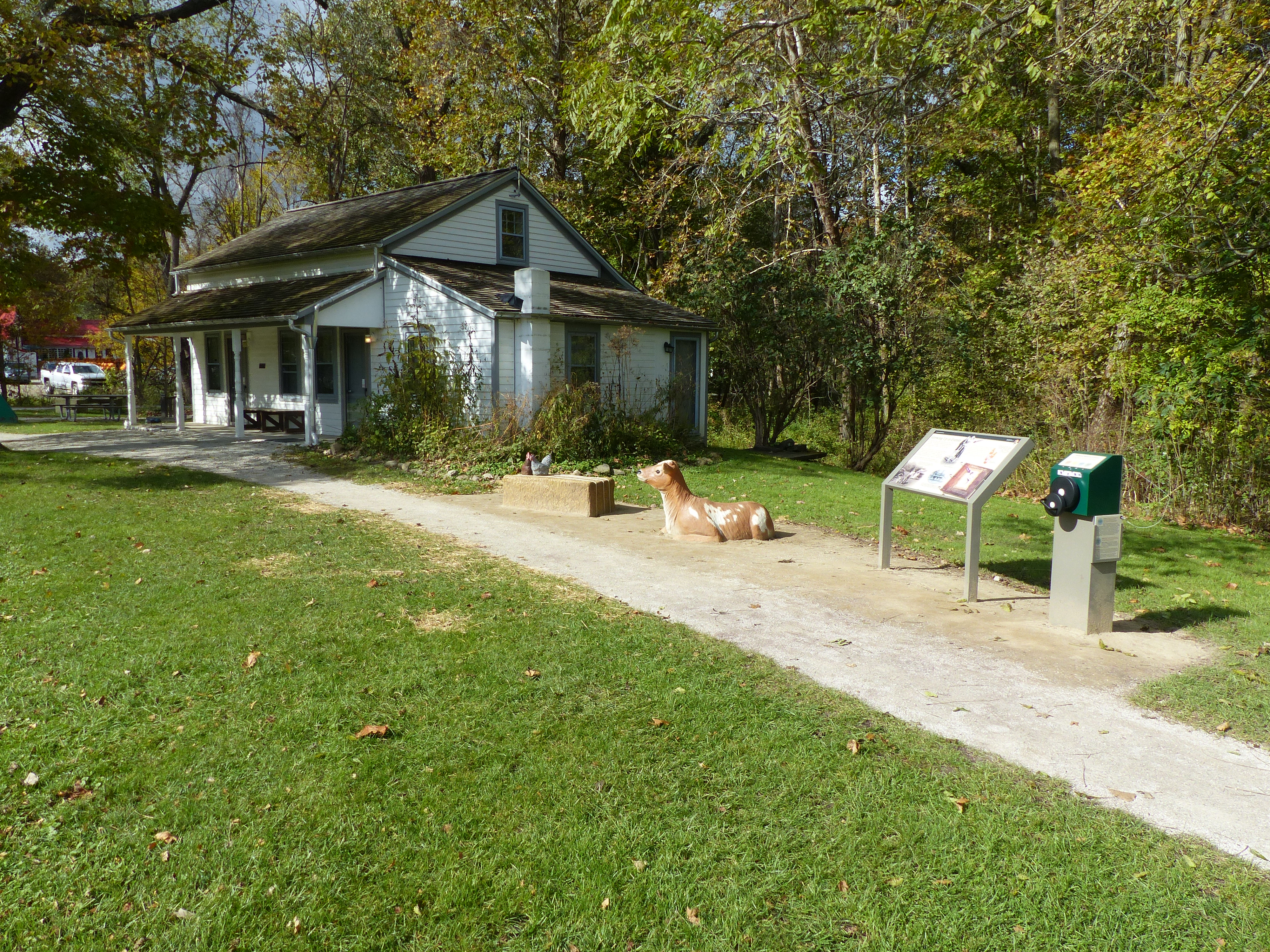
“Growing Up in Everett” exhibits explore farm life in the 1920s and 1930s through the eyes of Helen Fiedler Toth. Listen to her stories, flip through her photo album, and play with her calf and chickens.
Hunt House. 449 words. As you face this wayside graphic panel to the left is a small, white farm house. A ground-level covered porch extends across the front of the house with a bench next to the front door. At this end, under the peak of the roof is a window. Below an extension has been added to the house with a shed-style roof and a chimney at this end. The Towpath Trail runs past the house on the far side. Between the house and the graphic panel are touchable exhibits of farm animals. Nearest the panel is a life-size brown and white calf lying down, head up and alert. To the left of that is a hay bale where you can sit beside the two hens perched on the left end. One is brown and the other is speckled black and white. To the right of the panel is an audio station, a metal post with four push buttons on top to select the short programs. Farther to the right are two white buildings. The closer one is a two-story barn. The other one is smaller and has public restrooms. Behind you is a wide grassy lawn next to a street with a parking lot on the far side. Text on the panel reads in part, “Growing Up in Everett. […] Helyn was born in 1920 in the house to your left. She lived here through the 1940s with her parents and brother. Her father, William, held various jobs to support the family, but he loved farming. The Fiedlers raised vegetables in the fields behind the house. They had ‘a little roadside stand.’ Often vegetables and fruit were picked on demand as the customers waited. Helyn kept up friendships with her Everett classmates and neighbors until her death in 2013. Is there a place where you feel a strong sense of community?” At the bottom left is a photograph of Helyn’s father, William Fiedler, at the farm in the late 1940s, a cornfield in the background. The calf grazing to the left of him is the model for the touchable calf exhibit. At the middle top of the panel is a 1938 photograph of two 18-year-old girls, Helyn on the right with her friend Irene. Below them is a photograph of the farmhouse, looking much as it does today. At bottom right of the panel is a flipbook with more pictures and information about Helyn. The audio station to the right has childhood memories of Helyn and her friends. From left to right the audio segments are: Working Our Land, 60 seconds; One-room School, 40 seconds; Szalay’s Farm Next Door, 70 seconds; and Time for Fun, 70 seconds. End of description.
Cuyahoga Valley Scenic Railroad passengers can get on and off the train at Indigo Lake Station. Connector trails lead west to Hale Farm & Village and east to the Towpath Trail. The railroad coordinates a shuttle ride to Hale Farm & Village with select train excursions. Nearby parking is limited.
Indigo Lake Station. 447 words The rail station is on the right side of the path that leads from the parking lot. The tracks are just behind you. Be aware there are no barriers along the tracks. The station is a rectangular covered platform with a wall at each end. Posts along each side support the shingled roof. Wooden benches sit down the middle. The 20-foot-wide floor is made of wood boards and the structure is painted a creamy yellow. Standing with your backs to the tracks, a paved trail runs past the station on the left. On the other side of the trail is Indigo Lake with benches available on the grassy lawn near the lake. Graphic panels are hung on the inside of the end walls. At one end is a panel titled “Ride the Rails” which explains that the first steam engine in the valley began running in 1880 connecting the mineral fields in the south to the factories in the north. Today the Cuyahoga Valley Scenic Railroad follows much of the same route. Yellow paint on a station signifies a modern building. Historical depots are painted red. The panel shows a map of the rail line through the Cuyahoga Valley National Park, stretching from Rockside Station at the northern end to the Akron Northside Station at the southern end. The railroad and the Towpath Trail both follow the Cuyahoga River through the park. At the same end of the station is a glass-covered bulletin board with current information about the train and the park. The wall at the other end has two graphic panels. One is titled “Moving Farm Goods to Market.” Text on the panel explains that farming in the valley dates back to American Indian use of the land. Later settlers established hundreds of scattered farms raising wheat, corn, potatoes, sheep, and cows among other products. In the 1860s a new demand arose as Ferdinand Schumacker, founder of the Quaker Oats Company in Akron, sold his rolled oats to the Union Army during the Civil War. The canal made shipping farm goods quicker and more cost effective. The railroad improved transportation even more. Photographs on the panel include a picture of Schumacher’s Cascade Mills in Akron and bins of fresh farm goods in front of C.W. Bonstedt’s grocery in Akron. The other panel is titled “Crossroads Communities” which describes the nearby communities of Everett, Ira, and Botzum which emerged as trading centers in the 1800s due to their proximity to canal locks. The villages continued to be shipping and supply points with the arrival of the railway as each became home to a depot. Today Botzum and Ira are gone. End of description.
An exhibit cluster shares the remarkable story of nature’s recovery at Beaver Marsh, located a quarter mile to the north. Beavers and humans transformed a former auto salvage yard into a 70-acre wetland in the 1980s. Hands-on beaver, river otter, and muskrat sculptures introduce three mammals that depend on the marsh for their survival.
Ira Trailhead Exhibits. 461 words At the left side of the path that leads from the parking lot to the towpath is a tall graphic panel flanked on both sides by touchable models of animals common in the marsh. Two models are on the left of the panel – a beaver at left and an otter at right. The beaver is 18” long, faces to the right, and sits three feet high on a model of a beaver dam made of logs. Notice its wide, flat tail hanging down behind. To the right is an otter sitting on a two-foot-high boulder, facing left. Its thin body is 19 inches long with a long tail hanging down the back of the boulder. A fish lies on the rock by the otter’s front feet. To the right of the panel is another boulder, 2-foot high. There is a hollow cavity on the front of the boulder where a muskrat sits, facing left. His nine-inch-long body has an equally long, hairless tail. Near his left front paw is a cattail head. Flat cattail leaves lie on top of the boulder. The bottom of the graphic panel has a photograph of Beaver’s Marsh, the flat, still water broken by patches of marsh grasses. A low ridge shrouded in mist lies behind the marsh. Text at the top left reads, “From Salvage Yard to Beaver Marsh. Follow the Towpath Trail ahead to Beaver Marsh – one of the best places to view wildlife in Cuyahoga Valley National Park. Only a quarter-mile north, a boardwalk crosses this 70-acre wetland, transformed from an old salvage yard. Humans and beavers turned this site back into a marsh in the 1980s. Volunteers organized by a local Sierra Club removed cars and materials from the old business site. About the same time beavers flooded the area by building a dam across the Ohio and Erie Canal. The waters awakened long-dormant seeds of wetland plants -- a stunning example of nature recovering an area if given a chance. You may see a beaver nibbling on a willow branch, turtles sunning themselves on logs, and, if you are fortunate, otters at play. In spring and summer, frogs and songbirds sing in an exuberant chorus.” To the right of the text is a photograph of a small garage surrounded by rows of junk cars. The caption reads, “Burrell Tonkin’s auto repair shop and salvage yard were full of car bumpers, tires, and other auto parts.” Across the middle of the panel are four smaller photographs. From left to right they show a great blue heron surrounded by lily pads, a beaver crouched near reeds, a pair of otters side-by-side on a wetland stump, and two park volunteers making notes as they observe wildlife in the marsh. End of description.
This trailhead is popular for accessing the Beaver Marsh, located a half mile to the north on the Towpath Trail. The story of the Beaver Marsh has many chapters: a dairy farm, an auto salvage yard, and now a popular spot for viewing the wildlife, plants, and scenery of a recovering marshland.
Ira Trailhead. 420 words A three-sided, covered kiosk with a bulletin board and two graphic panels sits at the side of this parking lot. If you stand with your back to the parking lot, a small building with restrooms is to the left of the kiosk. To the right is a path which passes picnic tables and more exhibits, including touchable animal models. The path leads to the Towpath Trail. One of the graphic panels is titled “Welcome to Cuyahoga Valley National Park” and features a map of the park stretching along the Cuyahoga River with your current location at the southern end of the park marked. Text on the panel reads, “Since the 1800s, the Cuyahoga Valley has been a place where people from nearby cities relax in nature. Building on this tradition, locals worked tirelessly to preserve what is now Cuyahoga Valley National Park. Created in 1974, the park protects open countryside, a canal that helped build the nation, and the river that sparked the Clean Water Act. “Ira Trailhead. This is the gateway to Beaver Marsh, an extensive wetland popular for seeing and photographing wildlife. Once a dairy farm and then a salvage yard, the marsh reminds us of nature’s resilience. Walk a quarter-mile north on the towpath to the boardwalk viewing area. The trail is often congested. Use caution by staying to the right, controlling children and pets, and watching for passing cyclists.” The third side has a panel titled “Ohio and Erie Canalway” with a large black and white photograph of three mules pulling a canal boat on the canal. Smaller photographs show the Cuyahoga Valley Scenic Railroad, a group of children riding bicycles on the towpath, and the scenic byway that winds through the valley. A long map down the right side shows mileage between trailheads on the Towpath Trail. Text on the panel reads, “The Ohio and Erie Canalway celebrates the first 110 miles of a waterway that helped the nation grow. Dug by hand from 1825 to 1832, the Ohio and Erie Canal was the first canal west of the Appalachian Mountains. It connected Lake Erie to the Ohio River, providing a key link in an interstate shipping route. People and products flowed across America. Canal towns became major commercial centers. Ohio grew in population and wealth. Today you can explore the lasting impact of this historic public works project. Travel along the Canalway’s three spines. Discover how culture, recreation, and natural scenic beauty are being revitalized by this national heritage area.” End of description.
The Kendall Lake Pier was built by the Civilian Conservation Corps and originally served as a swimming pier. Today it serves as a fishing pier, a photography point, and a place to relax and enjoy nature.
Kendall Lake Pier and Shelter. 365 words This wayside graphic panel sits at the end of a wide pier that extends out into the small lake. As you face the panel the earthen pier stretches away from you back to the shore. All three sides of the pier are edged with wooden boardwalks. Several benches sit on the boardwalks and a picnic table sits in the middle of the grass-covered pier itself. At the end of the pier is a two-story stone building with open doorways leading to the lower floor and cement steps on either side leading to the second floor with its wide covered porch along the front. The lake stretches in the other three directions, an earthen dam located over your right shoulder. The edges of the lake are marshy with large stands of cattails. The entire area is wooded. Text at the top of the graphic panel reads, “Engineering Nature. Many of America’s parks were designed using naturalistic landscape principles developed in the early 1900s. The Kendall Lake area is an example of this design approach. Its idyllic setting was no accident. Once logged and farmed, the Kendall Lake landscape was molded by the Civilian Conservation Corps, or CCC, into the park you see today. CCC crews built a dam to create the lake, planted thousands of trees throughout the area, and built a bathhouse which seemed to grow out of the hillside.” At bottom left of the panel is a photograph looking down the pier from roughly your current position. Instead of a building backed by trees, there is a bare hillside with a couple of trucks at the left. The caption reads, “Kendall Lake beach area before bathhouse construction, circa 1935. Park architects designed the bathhouse to fit into this landscape.” On the right side is a smaller photograph with an aerial view of the Kendall Lake Bathhouse circa 1937. It shows the pier, small figures of people around its edges, and the two-story bathhouse set back from its end. Many more figures are in the water to the right and on a beach which lies to the right of the pier. Today the former beach area is covered in grass. End of description.
The Kendall Lake is one of the many amenities the Civilian Conservation Corps built in the Virginia Kendall Park. A one-mile trail loops around Kendall Lake. The Cross Country and Salt Run trails can also be accessed from this location.
Kendall Lake Trailhead. 455 words Here at the corner of the parking lot is a covered kiosk with a bulletin board and a graphic panel. Along the right side of the kiosk a paved path leads through a grassy area towards a pier which extends out into the small lake. Opposite the pier is a stone building. Directly behind you as you face the kiosk is a wayside graphic panel titled, “Honest Work.” The parking lot stretches to your left and behind you. The parking lot is edged with stone posts, one-foot square and ranging in height from one to two feet. Past the left side of the kiosk, the pavement leads to an unpaved path that enters the woods. The graphic panel on the kiosk is titled “Welcome to Cuyahoga Valley National Park” and features a map of the park stretching along the Cuyahoga River with your current location near the middle of the park indicated. Text on the panel reads, “Since the 1800s, the Cuyahoga Valley has been a place of retreat from urban life. Building on this tradition, citizens worked tirelessly to preserve what is now Cuyahoga Valley National Park. Created in 1974, the park protects open countryside, a canal that helped build the nation, and the river that sparked Earth Day and the Clean Water Act. “Coal industrialist Hayward Kendall willed his private retreat, later named Virginia Kendall Park, to the people of Ohio following his death in 1927. The Civilian Conservation Corps built Kendall Lake in 1934-35 for recreational use. For years, people flocked here for the swimming beach, toboggan run, and ice skating. Today’s visitors come to fish, rent snowshoes and cross-country skis, and enjoy nearby trails.” Text at the top of the wayside graphic reads, “The guard posts circling the parking lot are a result of the ‘honest work’ President Franklin D. Roosevelt believed the Civilian Conservation Corps, or CCC, would provide young unemployed Americans. Conceived under Roosevelt’s New Deal, the CCC put 250,000 young men to work rebuilding the country during the Great Depression. For the guard post project, corpsmen were taught how to quarry local Berea Sandstone and shape it into 3-foot by 1-foot by 1-foot posts. These posts were then ‘planted’ around most area parking lots. Over 1,000 guard posts were paced around the roads and parking lots of Virginia Kendall Park. The project achieved three major CCC goals: developing the nation’s park areas; teaching vocational skills; and providing work for young men.” At the bottom of the panel is a photograph of the young men at work installing the guard posts. Next to the photo is an engineer’s drawing showing that most of the 3-foot height of the posts was buried in the ground. End of description.
The Ledges Overlook provides an expansive view of the Cuyahoga Valley. From here, visitors can appreciate how the park protects a large tract of natural open space between the cities of Akron and Cleveland. The scenery is stunning in any season.
Ledges Overlook. 117 words Here at the edge of a steep hillside is a rocky outcrop. The rocks lie in large slabs to form a natural viewing platform looking west over the deciduous forest below. On either side and behind the outcropping are more woods, this area having hemlocks mixed in. The rocks on the left side as you face outward have eroded to form a rough stair step configuration. This becomes more irregular near the edge of the steep hillside, with channels cut at irregular intervals. Down below the treetops rise to just below the top of the ledge. The view stretches out over the tree-covered valley to end at a low ridge in the distance. End of description.
The Ledges Shelter is the largest Civilian Conservation Corps shelter in Cuyahoga Valley National Park. Groups and families with up to 75 people may reserve it for a fee.
Ledges Shelter. 438 words This wayside graphic panel faces a flagstone-paved patio sheltered by a long roof extending out towards us. A small stone building is at the far end of the shelter with another graphic panel on the wall there between sets of French doors. Under the shelter are two lines of picnic tables. Restrooms are located at the back of the building. As you face the panel to your right is a paved path leading from the parking lot behind you to the shelter. To the left is a wide, grassy lawn. At the top of the wayside panel is a quote from Franklin Delano Roosevelt which reads, “The overwhelming majority of unemployed Americans, who are now walking the streets and receiving private or public relief, would infinitely prefer to work. We can take a vast army of these unemployed out into healthful surroundings. We can eliminate to some extent at least the threat that enforced idleness brings to spiritual and moral stability.” Text to the right reads, “The Great Depression had left millions unemployed and desperate. In response to the crisis, President Franklin D. Roosevelt established the Civilian Conservation Corps, or CCC. The Ledges Shelter, before you, is a product of this back-to-work program.” The bottom of the panel has photographs of young men working, positioning heavy wooden beams on top of posts and pouring concrete. One photo shows a large group posing in front of a bare work site. Alongside the photographs are several quotes on the CCC building program in the Virginia Kendall area from the shelter’s architect, a CCC supervisor, and the Director-Secretary of the Akron Metropolitan Park District in 1934. The graphic panel on the wall of the shelter is titled “Welcome to Cuyahoga Valley National Park” and features a map of the park stretching along the Cuyahoga River with your current location near the eastern edge of the park indicated. Text on the panel reads, “Since the 1800s, the Cuyahoga Valley has been a place where people from nearby cities relax in nature. Building on this tradition, locals worked tirelessly to preserve what is now Cuyahoga Valley National Park. Created in 1974, the park protects open countryside, a canal that helped build the nation, and the river that sparked the Clean Water Act. “Coal industrialist Hayward Kendall willed his private retreat, later named Virginia Kendall Park, to the people of Ohio following his death in 1927. Managed by different agencies over the years, the park gave area residents more space for recreation and play. Most of the Virginia Kendall structures were built by the Civilian Conservation Corps in the 1930s.” End of description.
The striking rock cliffs of the Ledges are a primary feature of Virginia Kendall Park, developed in the 1930s. Use this trailhead to access a 1.8-mile trail that circles the Ledges, a rentable shelter, a giant grassy playfield, and many wooded picnic sites.
Ledges Trailhead. 275 words This covered kiosk with a bulletin board and a graphic panel sits along a wide, paved path which is a continuation of the Ledges Road which provides automobile access to this area. The path then passes the Ledges Shelter on the left and heads into the woods. As you face the kiosk the parking lot lies over your left shoulder. The shelter with its restrooms may be reached by a path at the left end of the parking lot or by passing the kiosk and turning left to cross the grassy lawn. The graphic panel on the kiosk is titled “Welcome to Cuyahoga Valley National Park” and features a map of the park stretching along the Cuyahoga River with your current location near the eastern edge of the park indicated. Text on the panel reads, “Since the 1800s, the Cuyahoga Valley has been a place where people from nearby cities relax in nature. Building on this tradition, locals worked tirelessly to preserve what is now Cuyahoga Valley National Park. Created in 1974, the park protects open countryside, a canal that helped build the nation, and the river that sparked the Clean Water Act. “Coal industrialist Hayward Kendall willed his private retreat, later named Virginia Kendall Park, to the people of Ohio following his death in 1927. Managed by different agencies over the years, the park gave area residents more space for recreation and play. Most of the Virginia Kendall structures were built by the Civilian Conservation Corps in the 1930s.” The bulletin board to the right of the panel has maps showing the network of looping trails available near this point. End of description.
Lock 26 was one of 44 locks that let canal boats step up from Lake Erie to the 968-foot-high Portage Summit in Akron. The Carter family lived nearby and had a dairy farm in addition to working on the Ohio & Erie Canal. Here in the Cuyahoga Valley, dairy farming was common, and the area became known as “cheesedom.” An exhibit at Lock 26 explores the Carter family story and local cheesemaking.
Lock 26. 453 words This wayside graphic panel is near the left end of the old lock, its walls at ground level near the path. There is water in the bottom of the lock and in the canal at either end. Lily pads are prevalent at the right end of the lock. Behind you on the other side of the path are wetlands. Trees line either side of the path. To the left of the panel is a backless bench. Along the bottom of the panel is a touchable profile with braille labels of the lock system. The edges of the profile can be sharp. Lake Erie at 573 feet is at the right end. Forty-four locks form stair steps up to the 968-foot-high Portage Summit at the left end. In between are Boston near Lock 32, Peninsula near Lock 29, and Mustill Store at Lock 15. Your current position at Lock 26 is near the middle of the profile. Text on the panel reads, “Life in Cheesedom. Canal, farm, railroad – all played a part in the lives of Charles and Susan Carter. They lived in a house next to Lock 26 and made a living in various ways. Charles served as a canal boat captain and locktender. The family also raised corn and hay on their 56-acre farm to feed their dairy cows. Though the community did not have any stores, taverns, or churches, Ira was a distribution point for dairy products. The Carters and other local farmers brought milk to the Hawkins Cheese Factory for processing. It was one of many in the region, which became known as ‘Cheesedom.’ From the nearby railroad depot, farmers shipped their cheese and fresh milk to urban areas.” In the middle of the panel is a black and white photograph of a small, two-story house next to a dirt path. The caption reads, “Charles and Susan Carters house bordered the canal towpath at Lock 26. Their son Darwin lived next door and helped run the family dairy farm.” At upper right is an image of a receipt from Hawkins Cheese Factory dated July 1901. “Farmers were paid every month for the milk they sold to the cheese factory.” Below that is a photograph of a man wearing a vest and hat. He stands on a depot platform, holding a bicycle next to him. Stacks of round boxes sit at the left side of the depot. The caption reads, “In this self-portrait, photographer Edwin Bell Howe stands at the railroad depot with stacks of cheese wheels. The depot was across from the cheese factory at the intersection of Ira and Riverview roads. The depot was named for Ira Hawkins, whose land was crossed by the tracks.” End of description.
Access the river from the Lock 29 Trailhead parking lot in Peninsula. Peninsula Depot and food are nearby.
Lock 29 River Access. 187 words The Cuyahoga River Water Trail access at Lock 29 is located on the northeast bank of the river. The path to the river access starts along the south border of the trailhead parking lot. It is rocky with a minor slope to the riverbank. A sign to the left has paddler information and hazards. When you reach the access point, the river will be in front of you. The access point has large rocks leading into the water with a large tree on either side. The river flows towards you before turning right under a pedestrian bridge for the Towpath Trail. Peninsula Depot is visible in the distance to the left. The Lock 29 restrooms are visible through the trees if you turn left. The back of river trail sign is also to the left. The front of the sign is dark blue with the Cuyahoga River Water Trail logo and “Lock 29 Trailhead.” Underneath the text is a lighter blue shaded area with the number “29.0” indicating the river mile. The terrain is uneven and made up of large rocks. End Description
The Ohio & Erie Canal made Peninsula a busy industrial town and popular overnight stop for canal travelers. Today visitors can stroll through the historic downtown, shop, and dine. Lock 29 Trailhead is a popular, often crowded access point for the village, Towpath Trail, Cuyahoga Valley Scenic Railroad, and Cuyahoga River Water Trail. On the towpath, travel 2.3 miles north to the village of Boston. About a mile south is Deep Lock and connecting trails to old stone quarries.
Lock 29 Trailhead. 428 words A three-sided, covered kiosk with a bulletin board and two graphic panels sits at the edge of the parking lot to the left of a sidewalk that leads to the Towpath Trail and more exhibits at Lock 29. As you face the kiosk, the river bend is to the left. Restrooms are located in a small building on the other side of the parking lot near the train tracks. One of the graphic panels is titled “Welcome to Cuyahoga Valley National Park” and features a map of the park stretching along the Cuyahoga River with your current location in the middle of the park marked. Text on the panel reads, “Since the 1800s, the Cuyahoga Valley has been a place where people from nearby cities relax in nature. Building on this tradition, locals worked tirelessly to preserve what is now Cuyahoga Valley National Park. Created in 1974, the park protects open countryside, a canal that helped build the nation, and the river that sparked the Clean Water Act. “Lock 29 Trailhead. The Ohio and Erie Canal made Peninsula a busy industrial town and popular overnight stop for canal travelers. The village had boatyards, mills, hotels, taverns, and other businesses. Today visitors can stroll through the historic downtown and stop to shop and dine. Travel 2.3 miles north on the towpath to the historic village of Boston. About a mile south is Deep Lock and connecting trails to old stone quarries.” The third side has a panel titled “Ohio and Erie Canalway” with a large black and white photograph of three mules pulling a canal boat on the canal. Smaller photographs show the Cuyahoga Valley Scenic Railroad, a group of children riding bicycles on the towpath, and the scenic byway that winds through the valley. A long map down the right side shows mileage between trailheads on the Towpath Trail. Text on the panel reads, “The Ohio and Erie Canalway celebrates the first 110 miles of a waterway that helped the nation grow. Dug by hand from 1825 to 1832, the Ohio and Erie Canal was the first canal west of the Appalachian Mountains. It connected Lake Erie to the Ohio River, providing a key link in an interstate shipping route. People and products flowed across America. Canal towns became major commercial centers. Ohio grew in population and wealth. Today you can explore the lasting impact of this historic public works project. Travel along the Canalway’s three spines. Discover how culture, recreation, and natural scenic beauty are being revitalized by this national heritage area.” End of description.
Lock 32 was one of 44 locks on the Ohio & Erie Canal between Lake Erie in Cleveland and the Portage Summit in Akron. Historically, McBride’s Grocery served canallers at Lock 32.
Lock 32. 309 words This wayside graphic panel is near the right end of the lock walls, which are all that remain. This end of the lock is partially filled allowing access to the inside where the walls can be felt. Inside, the ground slopes down to the other end of the lock where the ground is marshy and may have standing water and higher vegetation. The left end of the lock has a wooden bridge with railings spanning the width giving closer views of that end. Text on the panel reads, “Boston Booms. The opening of the Ohio and Erie Canal turned Boston, a modest frontier settlement, into a thriving village. Between 1828 and 1836, increasing canal traffic sparked the opening of businesses. They included a blacksmith shop, hotel, tavern, two general stores, boatyard, brickyard, lumber mill, broom factory, and warehouse. McBride’s Grocery served canallers waiting to pass through Lock 32.” The right side of the panel has a black and white photograph of McBride’s Grocery next to Lock 32 with the Boston Store in the distance as the view would have been looking right from your current location. The buildings are white wood-frame with two stories. The lock gate is closed, some water spilling underneath it into the bottom of the lock while the water beyond is at a higher level. An arrow highlights the bare sandstone blocks on the walls of the lock, indicating that the photo was taken before 1905. Along the bottom of the panel is a touchable profile of the stairstep locks from the 968-foot high Portage Summit at Lock 1 at the right end and Lake Erie at 573-foot-elevation at the left end. You are currently at Lock 32 at Boston, to the left of the mid-point. As you explore the lock profile be careful of sharp corners on the stair steps. End of description.
Read about the “laughter and tears” of the Murphy family who once had a farm at Lock 35.
Lock 35. 288 words The towpath here runs through quiet woods. The canal bed is dry and the lock is mostly filled with dirt, leaving a grassy area inside and on either side of the remaining low, stone walls. The inside of the lock may be reached from either end. Touch the walls inside to feel the weathered blocks. Text on the small wayside graphic panel reads, “Laughter and Tears. ‘There was no electricity, no running water,’ Paul Murphy recalled about growing up on a farm just south of here in the early 1900s. ‘In winter our house was heated by a stove in the living room and a cook stove in the kitchen. Homemade bread, biscuits, and pies were made from the flour that we brought back from the Wilson mill. Many a joyful trip was made in the sleigh behind our faithful horse, with the music of bells to accompany the songs we sang. The canal was a favorite spot for skating parties of people of all ages. We had our full share of both pleasure and frustration, of laughter and tears.’” At bottom left is a small black and white photograph of Paul and his mother Emma. It shows a gray-haired woman with wire-rimmed glasses and a dark-haired man. The caption tells us that Paul wrote about his memories in a manuscript entitled “Treasures of the Valley, A True Experience.” The right side of the panel shows a 1939 painting of the Murphy farmhouse by Maude McKisson, Paul’s sister-in-law. The winter scene looks south with the canal running along the left and a small log house sitting at the right. The banks are snow covered and the scene is lit only by a full moon. End of description.
By the remains of Lock 36, visitors can explore the Pinery Feeder which still “feeds” water from the Cuyahoga River into this section of the Ohio & Erie Canal.
Lock 36. 376 words This wayside graphic panel is located near a fork in the path where a side trail separates from the Towpath Trail and loops to the west along the river. As you face the panel, the fork is to the left. The river is behind you. The Towpath Trail crosses a footbridge in front of you which goes over a channel of water. The channel runs from the river at the right and connects with the canal downstream at the left. The canal runs along the base of a wooded slope on the far side of the Towpath Trail. Text on the panel reads, “Feeding the Canal. Soon after this canal section opened in 1827, engineers built the Pinery Dam and Brecksville Feeder. This channel carries water from the Cuyahoga River into the canal at Lock 36. Originally the additional water maintained a proper depth for canal boats. Today this feeder provides water to the longest intact section of the Ohio and Erie Canal, a national historic landmark.” At the lower left is a 1907 photograph taken from the large hill to your left. It shows three channels of water – the Cuyahoga River on the right, the Ohio and Erie Canal on the right and the Brecksville Feeder on an angle connecting the two. The caption reads, “On the far side of today’s trail bridge, notice the remnants of Lock 36. The lock chamber was filled when the Brecksville-Northfield High-Level Bridge was built in the 1930s.” The right side of the panel is filled with a 1900 photograph of a team of three horses waiting to resume towing a boat in Lock 36. They stand at the left with a man on the towpath. A boat sits in the canal which runs down the right side of the picture. A small building is on the right side of the canal and a hillside rises steeply in the background. The slope has far fewer trees compared to today. At the top of the panel is a quote from the Ohio Canal Division Reports, 1880, which reads, “The dam and feeder are said to be in good condition. This furnishes all the extra water needed between this point and Cleveland and has always been ample.” End of description.
Lock 37 was once a busy location with a tavern, mill and floodgate. A small parking lot on nearby Fitzwater Road provides access to the Towpath Trail.
Audio Description. Lock 37 and Water Control Gate. 432 words. At this point on the Towpath Trail near the concrete marker for mile 14 there are two small graphic wayside panels. On the canal side is one titled “Lock 37” which sits next to the old lock which has water at its bottom. The sides of the lock are weathered, worn concrete covering the upper part and the underlying blocks visible below. The gates are gone, but there is a stationary barrier, stone at the bottom, wooden beams above, which blocks the downstream end. There is no guardrail at the edge of the 10-foot-deep lock. The graphic panel features an artist’s illustration of a freight boat in the lock in 1863. A large white building beyond the lock on the left is the Alexander/Wilson Mill, still there today partially hidden by trees. The illustration shows several buildings on the right, now gone, which were the Vanoucek tavern, store, house and barn. Text on the panel reads, “Family Businesses. Canal locks attracted businesses to serve canal boat crews, locals, and farmers. Here at Lock 37 the Vanouceks ran a tavern and general store and the Alexander family operated a gristmill. A spillway allowed excess water to flow around the lock. The mill used the spillway’s waterpower to grind grain into flour and livestock feed.” The other wayside panel, titled “Floods and Repairs,” is down the path to the right as you face the lock. It sits on the other side of the path near the river which lies close to the canal at this point. Just past the panel is a wooden bridge without railings that crosses a small channel which carries water between the canal on the left and the river on the right. Four gear-like mechanisms line the right side of the bridge which control openings in a gate below. Text on the panel reads, “Regulating Water Level. Canal engineers did not foresee the intensity of valley floods and later added structures to control water levels. Here a National Park Service worker adjusts a floodgate built in the early 1900s. Look closely at the actual structure. Can you see the small gates below where the worker is standing? Gates are opened to drain off water so canal repairs can be made here or downstream. During floods, excess water is diverted to protect the canal from being damaged. A waste way takes the water to the Cuyahoga River.” The photograph on the panel shows a man in a National Park Service uniform using a long metal rod to turn one of the gear mechanisms. End of description.
What is a canal lock? Stop here to learn about the mechanics of these boat elevators. If you are lucky to have water in the canal on a summer weekend, you might see volunteers demonstrating how Lock 38 works.
Lock 38. 470 words This wayside graphic panel sits at the downstream end of the lock. Behind the exhibit, a small wooden footbridge crosses to the other side. To the right of the bridge are the heavy wooden gates that close this end of the lock. Each gate has a long wooden beam attached along its top and extending out to the side. A similar pair of gates sit at the upper end of the lock to the right. On the other side of the towpath is a white-frame building that held a tavern and store. To the left of the lock is a road and bridge crossing the canal. That road ends at the scenic byway on the far side. The inside walls of the lock are made of concrete-covered stone blocks. The tops of the walls are even with the ground and there is no guardrail. At the left side of the panel, text reads, “Lock 38 is one of the few restored, working locks along the historic Ohio and Erie Canal. Locks are like elevators – they raise and lower boats between levels. State engineers designed 44 locks to deal with a 395-foot rise in elevation from Cleveland to Akron. Heavy wooden gates enclose the boat-sized stone chamber. Lock operators added water to the chamber to raise a boat headed upstream. They drained out water to lower a boat headed downstream.” The right side of the panel has a drawing of one of the wooden gates with its beam extending over the lock wall to the right, a man pushing on the end. Arrows indicate features of the diagram. The caption next to the end of the beam reads, “Balance beam. A long beam balances out each heavy gate. The beam makes it possible to open and close the gate by hand.” At the bottom of the gate is a small door called a wicket. The caption reads, “The gates cannot open unless the water level is the same on both sides. A valve at the bottom of each gate, called a wicket, lets water in or out.” At the top of the gate is a long shaft called a wicket stem connected to the wicket below. The caption reads, “Boatmen opened and closed the wicket using a large wrench to turn the wicket stem and pivot the wicket.” The gate itself is called a whaler gate. The caption reads, “Two gates at each end keep the water in the chamber.” At lower left is a photograph of the lock empty of water, showing the smooth vertical walls and a flooring made of wooden beams. The caption reads, “In the 1980s National Park Service workers restored Lock 38 to how it looked in 1907. This was just after the state lined locks with concrete. Notice the wooden floor.” End of description.
Lock 39 is the northernmost lock in Cuyahoga Valley National Park. It is one of many canal remnants you can see as you walk, ride, or run along the Towpath Trail.
Here on the canal is an old lock structure. At the side of the towpath near the lock a graphic panel describes the function of the locks. At the bottom of the panel is a touchable profile of the 44 stair-step locks between Lake Erie in Cleveland and the portage summit in Akron. To the right of the panel is a bench made of wooden beams between two concrete bases. Across the path from the canal is an overgrown field backed by woods. The canal and lock contain water. The sides of the lock are made of stone and concrete. At the left, or northern end, a small footbridge crosses the lock to a grassy area on the other side. The end of the lock closest to the graphic panel is closed with a thick, wooden barrier keeping the water level feet below ground level. On the northern side of the barrier gate, the water is ten feet below the ground level. Exercise caution near the lock as there is no guardrail. Water trickles under the barrier to fall into the deep lock. The background of the graphic shows a black and white photograph of a functional lock. The view up the lock shows the block walls and water splashing through the partially open, heavy wooden gate at the end. A note tells us that “Canal managers covered the blocks with concrete during a 1905-1906 renovation.” Along the bottom of the panel is a touchable profile with braille labels of the lock system. The edges of the profile can be sharp. Lake Erie at 573 feet is at the left end. Forty-four locks form stair steps up to 968-foot-high Portage Summit at the right end. In between are Boston at Lock 32, Peninsula at Lock 29, and Mustill Store at Lock 15. Text on the panel reads, “Stepping Up and Down. Locks act like elevators, raising and lowering boats. Most locks along the Ohio and Erie Canal had a lift of about nine feet. It took 44 locks to manage the 395-foot elevation rise between Cleveland and Akron. Canal engineers numbered locks in both directions from Akron’s Portage Summit. In operation from 1827 to 1913, the canal turned the sleepy village of Cleveland into a major port. Boats carried timber and farm products to Lake Erie and returned with manufactured goods and specialty foods.” End of description.
Access the river from the Lock 39 Trailhead in Independence. This site allows access for a long paddle, nearly 12 miles, into Cleveland. Rockside Station and food are nearby.
Lock 39 River Access. 200 words. The Cuyahoga River Water Trail access at Lock 39 is located on the east bank of the river. The path to the river access starts at Lock 39 Trailhead, in the southwest corner of the parking lot. The path to the access point is north of the pedestrian bridge to Rockside Station. It is a dirt trail through the woods with tree branches along the path. The path slopes downward as you approach the river. When you reach the access point, the river will be in front of you. The ground flattens out as you reach the river. The ground has loose rock and dirt that leads into the water. The flat area extends left and ends just below the pedestrian bridge, left. The pedestrian bridge extends over the river connecting Lock 39 and Rockside Station. To the left and behind you is a dark blue sign that has the Cuyahoga River Water Trail logo with “Lock 39 Rockside Road.” Underneath the text on the sign is a lighter blue shaded area with the number “13.2.” To the right the Rockside Road is visible. The terrain is uneven and has trees and sticks throughout. End of description.
This is the northernmost trailhead within Cuyahoga Valley. From here, visitors can explore the Towpath Trail south into the national park or north into Cleveland Metroparks. Across the parking lot is an access point for the Cuyahoga River Water Trail and a pedestrian bridge to Rockside Station.
Lock 39 Trailhead. 470 words A three-sided, covered kiosk sits at the side of the smooth, unpaved Towpath Trail next to a small bench. One side has a bulletin board with current news, while the other two sides have graphic panels. On the other side of the path is the canal, water at its bottom and a steep, brush-covered bank on the other side. A wooden post next to the canal has a small sign that reads “Lock 39, Towpath Trail.” Going left on the path leads to Cleveland Metroparks. Going right leads to the Canal Exploration Center. Trees and bushes line the side of the path opposite the canal. One of the graphic panels is titled “Welcome to Cuyahoga Valley National Park” and features a map of the park stretching along the Cuyahoga River with your current location at the northern end of the park marked. Text on the panel reads, “Since the 1800s, the Cuyahoga Valley has been a place where people from nearby cities relax in nature. Building on this tradition, locals worked tirelessly to preserve what is now Cuyahoga Valley National Park. Created in 1974, the park protects open countryside, a canal that helped build the nation, and the river that sparked the Clean Water Act. “Lock 39 Trailhead. The Rockside name probably comes from the many small quarries that once dotted this area. Travel by foot, bicycle, or rail to learn about Ohio’s transportation history. Canal Exploration Center is 1.75 miles south on the Towpath Trail. The CanalWay Center of Cleveland Metroparks is about four miles north. From the nearby trailhead parking lot, cross the footbridge to reach Rockside Station. This is the northern starting point for the Cuyahoga Valley Scenic Railroad.” The third side has a panel titled “Ohio and Erie Canalway” with a large black and white photograph of three mules pulling a canal boat on the canal. Smaller photographs show the Cuyahoga Valley Scenic Railroad, a group of children riding bicycles on the towpath and the scenic byway that winds through the valley. A long map down the right side shows mileage between trailheads on the Towpath Trail. Text on the panel reads, “The Ohio and Erie Canalway celebrates the first 110 miles of a waterway that helped the nation grow. Dug by hand from 1825 to 1832, the Ohio and Erie Canal was the first canal west of the Appalachian Mountains. It connected Lake Erie to the Ohio River, providing a key link in an interstate shipping route. People and products flowed across America. Canal towns became major commercial centers. Ohio grew in population and wealth. Today you can explore the lasting impact of this historic public works project. Travel along the Canalway’s three spines. Discover how culture, recreation, and natural scenic beauty are being revitalized by this national heritage area.” End of description.
Start your visit to Cuyahoga Valley National Park at Boston Mill Visitor Center. Meet park staff, get questions answered, and learn about the park and places to visit. The visitor center is open daily from 9:30 am to 5 pm, March through December. January and February, hours are shortened. For the summer season, hours are extended and additional staff are available outside the visitor center to assist with trip planning, weather permitting. Restrooms stay open even when the visitor center is closed.
Discover the Ohio & Erie Canal in the storied Canal Exploration Center that was once used as a tavern, a general store, a residence, and a park visitor center. Find out how the canal shaped the nation through in-depth, interactive Canal Era exhibits for children and adults. Restrooms at the trailhead stay open even when Canal Exploration Center is closed.
Hunt House offers child-friendly nature exhibits, a rest area along the Towpath Trail, and information about nearby attractions. Hunt House is open seasonally as staffing allows. Restrooms stay open even when Hunt House is closed.
The East Rim Trail system has stunning views, varied terrain, exciting obstacles, and an element of adventure for intermediate mountain bikers.
Hike the Brandywine Gorge Loop
The Brandywine Gorge Loop circles a deep ravine carved by Brandywine Creek, and provides stunning views of Brandywine Falls along the way. Learn more about hiking this popular trail.
Become a Cuyahoga Valley Junior Ranger
Learn how kids ages 3 and older can become Junior Rangers of Cuyahoga Valley National Park.
Hike the Ledges Trail
The Ledges Trail circles a plateau of striking rock formations and provides stunning views along the way. Learn more about hiking this popular trail.
Visit Cuyahoga Valley Farms and Markets
Agriculture has long been an important part of life in the Cuyahoga Valley. Today, there are eight farms that operate within the national park. Several have roadside stands or host events throughout the year. Learn more about these farms and about weekly farmers markets in and around the park.
Visit Canal Exploration Center
Arrive by car, bike, or scenic railroad. Hands-on exhibits at this historic tavern and store bring the canal era to life. Lock demonstrations are offered seasonally. From here, you can stroll the Towpath Trail.
Find the Best Fall Colors in Cuyahoga Valley
Leaf peepers, grab your cameras! Here are our tips for where to find Cuyahoga Valley’s best fall colors throughout October.
Stop by Boston Mill Visitor Center
Begin your adventure at Boston Mill Visitor Center. Pick up maps and shop for souvenirs. Staff and volunteers are available to help you plan a visit that fits your time and interests.
Go Fishing in the Cuyahoga Valley
Fishing is a great way to spend your day in Cuyahoga Valley National Park. Learn about the best places to fish and how to responsibly enjoy this pastime.
Hike to Blue Hen Falls from Boston
Blue Hen Falls is a popular hike-in destination in the Boston area. Hikers can reach the waterfall via the Buckeye Trail from Boston Mill Visitor Center. Learn more about this popular hilly hike.
Short Towpath Trail Walks
These short walks along the Towpath Trail explore many highlights of the valley’s lowlands. They are recommended for people who have mobility disabilities, are visiting with children, or have limited time.
Find Spring Wildflowers in Cuyahoga Valley
Searching for wildflowers is a great way to connect with nature and stay active in spring. Discover what’s blooming along park trails.
Go Birding in the Cuyahoga Valley
Birding is a popular activity at Cuyahoga Valley National Park. Thanks to the park’s wide variety of habitats, it is possible to observe more than 200 bird species throughout the year. Grab a field guide and a pair of binoculars and see what awaits your discovery.
Go Snowshoeing in the Cuyahoga Valley
Snowshoeing is a great way to explore and exercise in Cuyahoga Valley National Park when the conditions are right. There must be at least four inches of packed snow on the trail.
Kid- and Autism-friendly Activities in the Everett Area
Three short walks in the Everett area offer sensory activities that appeal to children or individuals with autism. They include tactile and audio exhibits.
Let's Go Canalway Questing
Put your detective hat on! Quests are fun, self-guides hikes that help you explore the Ohio & Erie Canalway. Follow rhyming clues to hidden boxes. Sign the logbook and collect impressions of each hand-carved stamp.
Plan Your Event at Cuyahoga Valley
Find out how you can host an event in the park.
Tours
Count: 2
Ever-changing Boston Walking Tour
The village of Boston may look like it has not seen progress or change in years, yet the area has transformed repeatedly. Explore the pros and cons of progress. This walk is intended to be around 35 minutes in length, covering about a mile over roads and trails of flat terrain. Be aware that this walk uses current paths, trails and roadways, all adjacent to Boston Mills Road and an active railroad line. At times, noise may be an issue. Watch for cyclists along the Towpath Trail.
Native American Heritage Walking Tour
For thousands of years, Native peoples have lived, raised families, and created culture in the Cuyahoga Valley. This flat, unpaved walk is a little over two miles out and back on the Towpath Trail. It explores the remnants these peoples left on the land. Be aware: at times, nearby Canal Road can be noisy.