Be advised that the NPS has issued alerts for this park.
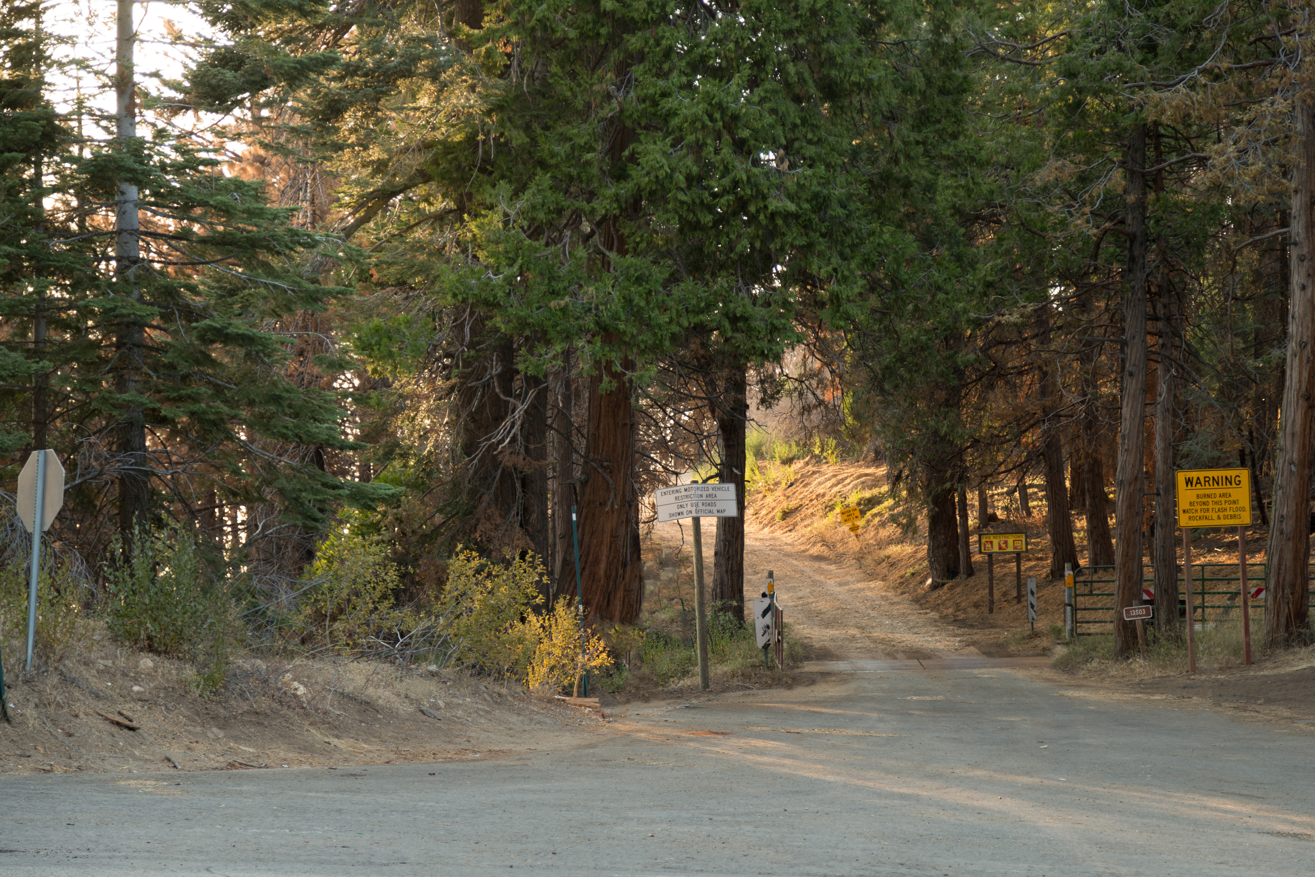
Mineral King Road Experiencing Construction Closures and Delays Except on Sundays
A portion of Mineral King Road inside Sequoia National Park is under construction. There is a mixture of up-to-30-minute delays and closures from 7 am to 7 pm Monday through Saturday. No delays or closures on Sundays or holidays. Click "more" for details:
A Few Small Roads Closed Due to Roadway Damage
These roads are closed due to roadway damage during past storm events and/or repairs to roadway damage: Middle Fork Rd, Redwood Canyon Rd, South Fork Rd, Crystal Cave Rd
Fire Restrictions in Place
Stage 1 Fire Restrictions are in effect. Wood and charcoal fires are prohibited at all low-elevation campgrounds and picnic areas. Additional restrictions apply. Click "more" for details.
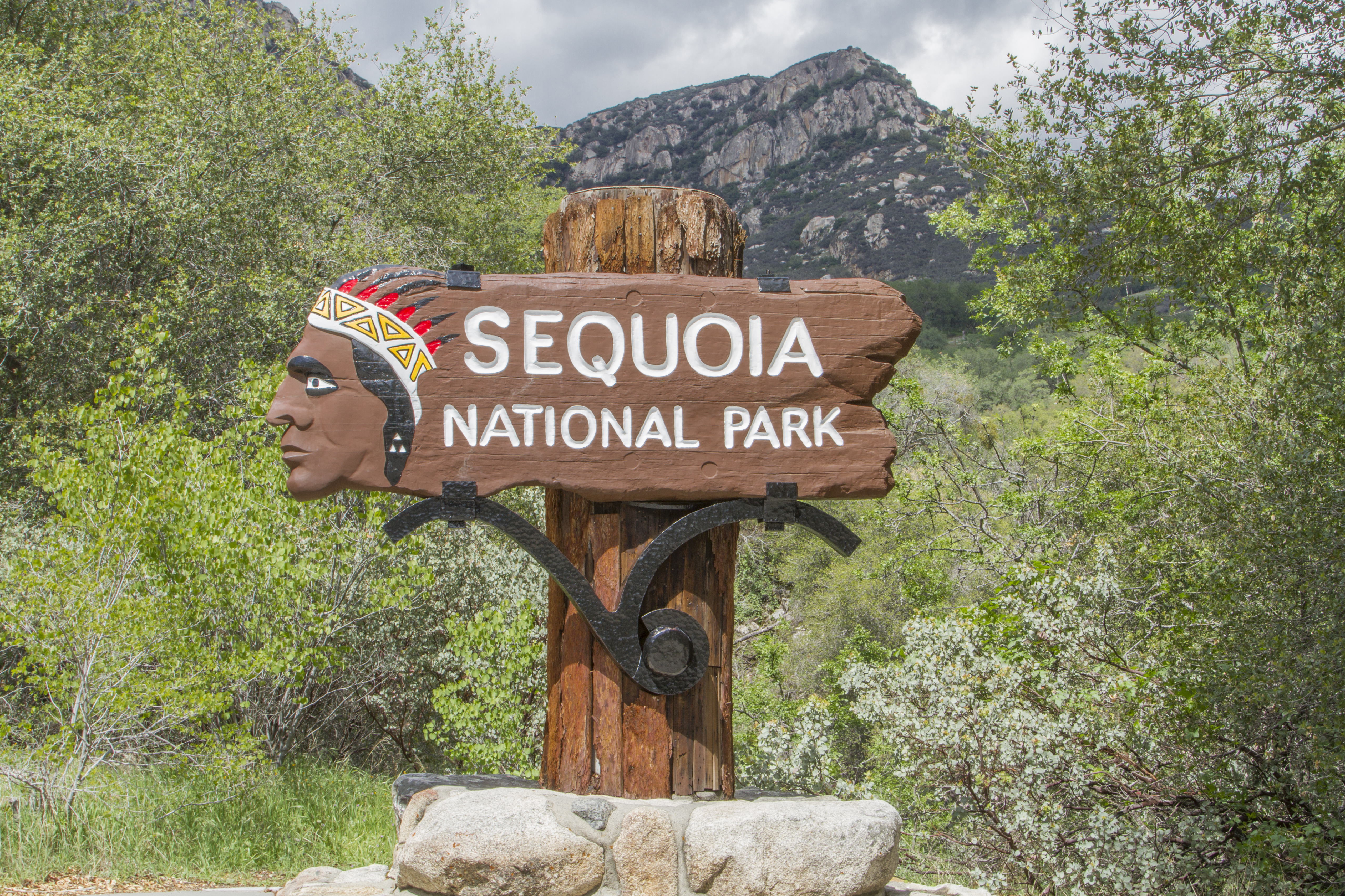
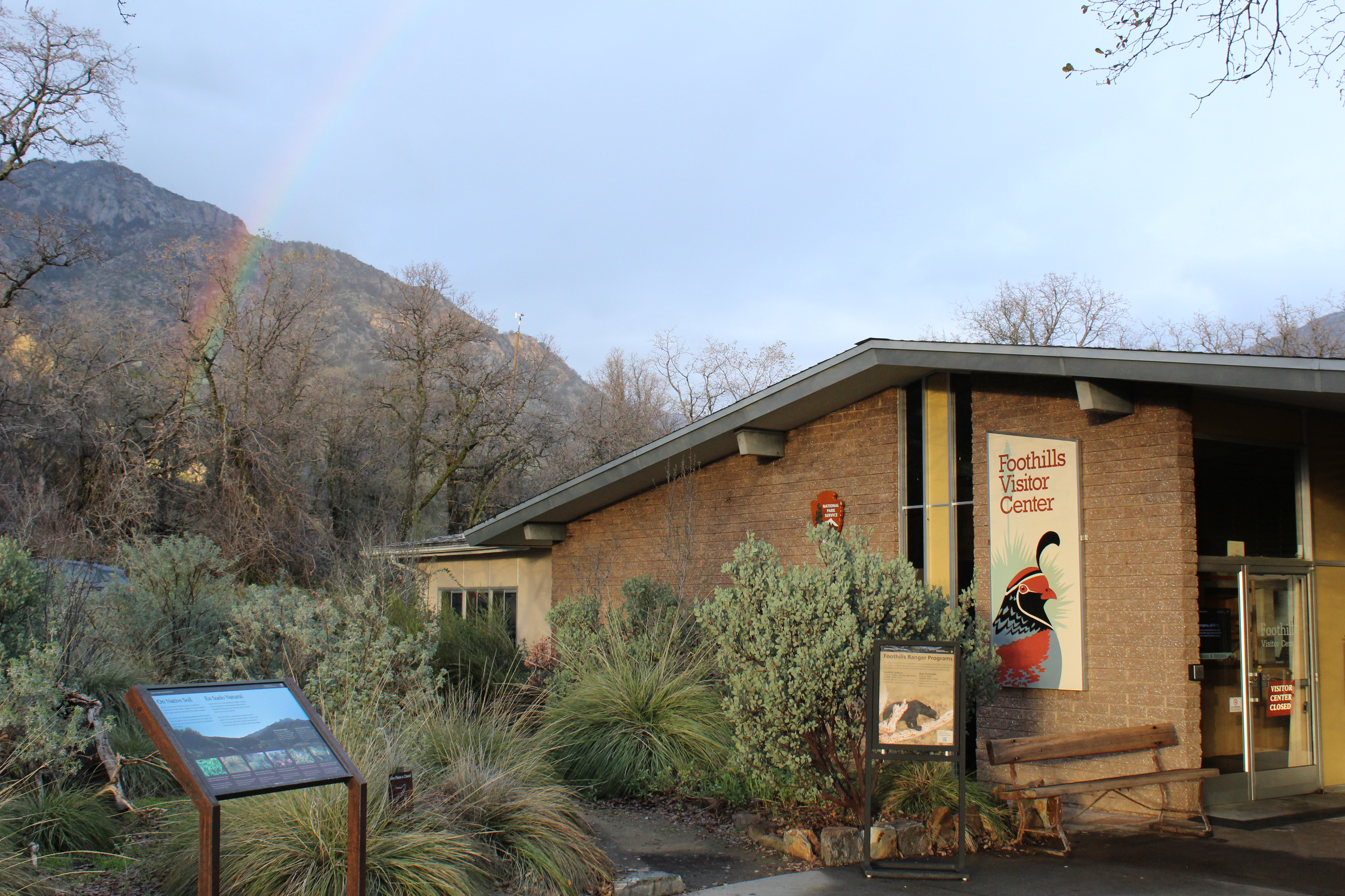
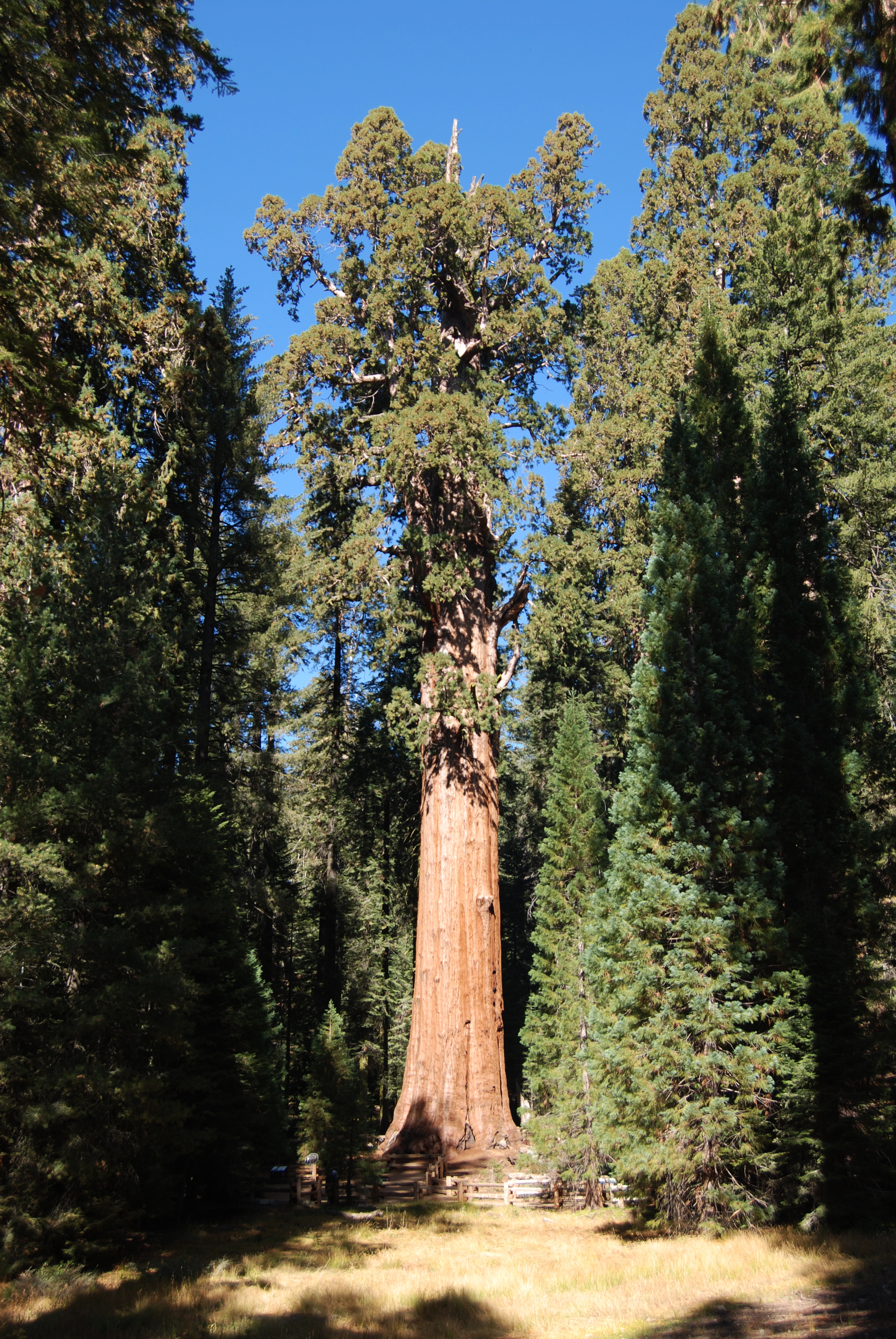
Huge mountains, rugged foothills, deep canyons, vast caverns, and the world’s largest trees exemplify the diversity of landscapes, life, and beauty here. Explore these pages to plan your visit or to learn about the plants and animals here and the...
This pass is valid for 1-7 days and includes everyone traveling in a single vehicle for Sequoia & Kings Canyon National Parks and Hume Lake District of Sequoia National Forest/Giant Sequoia National Monument.
Entrance - Per Person
$20.00
This entry fee is for a single person traveling on foot or by bicycle. It is valid for 1-7 days in Sequoia & Kings Canyon National Parks and Hume Lake District of Sequoia National Forest/Giant Sequoia National Monument.
Entrance - Motorcycle
$30.00
This pass is valid for 1-7 days and includes everyone traveling on a motorcycle, scooter, or similar motorized vehicle for Sequoia & Kings Canyon National Parks and Hume Lake District of Sequoia National Forest/Giant Sequoia National Monument.
Entrance - Non-commercial Groups
$20.00
Non-commercial groups traveling in vehicles that have a capacity of up to 15 passengers pay a $35 vehicle entrance fee or use a park pass. Groups traveling in a bus or vehicle with a capacity of 16 persons or more are charged $20 per person, up to the maximums listed for commercial groups with comparable passenger capacity ($100 or $200). People 15 years old or younger, anyone with a pass that may be used for park entry, and drivers hired for transportation only are exempt from the per person fee.
Commercial Entrance - Van
$75.00
This entrance fee is for commercial tours of vehicles with a seating capacity of 7-15 people that has been packaged, priced, or sold for leisure or recreational purposes by an organization that realizes financial gain through the provision of the service. This fee is based on the seating capacity of the vehicle and not the actual number of passengers. Passenger ages or entrance passes do not affect the price.
Commercial Entrance - Mini-bus
$100.00
This entrance fee is for commercial tours of vehicles with a seating capacity of 16-25 people that has been packaged, priced, or sold for leisure or recreational purposes by an organization that realizes financial gain through the provision of the service. This fee is based on the seating capacity of the vehicle and not the actual number of passengers. Passenger ages or entrance passes do not affect the price.
Commercial Entrance - Motor Coach
$200.00
This entrance fee is for commercial tours of vehicles with a seating capacity of 26 or more people that has been packaged, priced, or sold for leisure or recreational purposes by an organization that realizes financial gain through the provision of the service. This fee is based on the seating capacity of the vehicle and not the actual number of passengers. Passenger ages or entrance passes do not affect the price.
Commercial Entrance - Sedan
$25.00
The charge for vehicles with a seating capacity of 1-6 passengers is $25, plus $20 per passenger, with a maximum total fee of $75. This entrance fee is for commercial tours of one or more people traveling on an itinerary that has been packaged, priced, or sold for leisure or recreational purposes by an organization that realizes financial gain through the provision of the service. Passenger ages or entrance passes do not affect the price.
Commercial Entrance - Per Person
$20.00
The per person fee for vehicles with a seating capacity of 1-6 passengers is $20, plus $25 per vehicle, with a maximum total fee of $75. This entrance fee is for commercial tours of one or more people traveling on an itinerary that has been packaged, priced, or sold for leisure or recreational purposes by an organization that realizes financial gain through the provision of the service. Passenger ages or entrance passes do not affect the price.
Reservations for Atwell Mill Campground typically open in April and can be made up to one month in advance of your stay. All sites are reservation only.
From November until May, Azaela Campground has 20 sites open on a first-come, first-served basis. When sites are first-come, first-served, payment is done through the Recreation.gov mobile app. Please download the app before coming to the park (www.recreation.gov/mobile-app). Cellular service is very limited. As long as the app is installed prior to arrival, payment will work even when a device does not have internet connection. For those same 20 sites, reservations for the summer begin in early January and can be made up to four months in advance of your stay. 90 additional sites open about two weeks later.
Buckeye Flat Campground does not have a determined reopening date due to ongoing storm damage repair. Reservations for Buckeye Flat Campground are available up to one month in advance of your stay. All sites are reservation only.
Reservations for Canyon View Group Campground typically open in January and can be made up to four months in advance of your stay. All sites are reservation only.
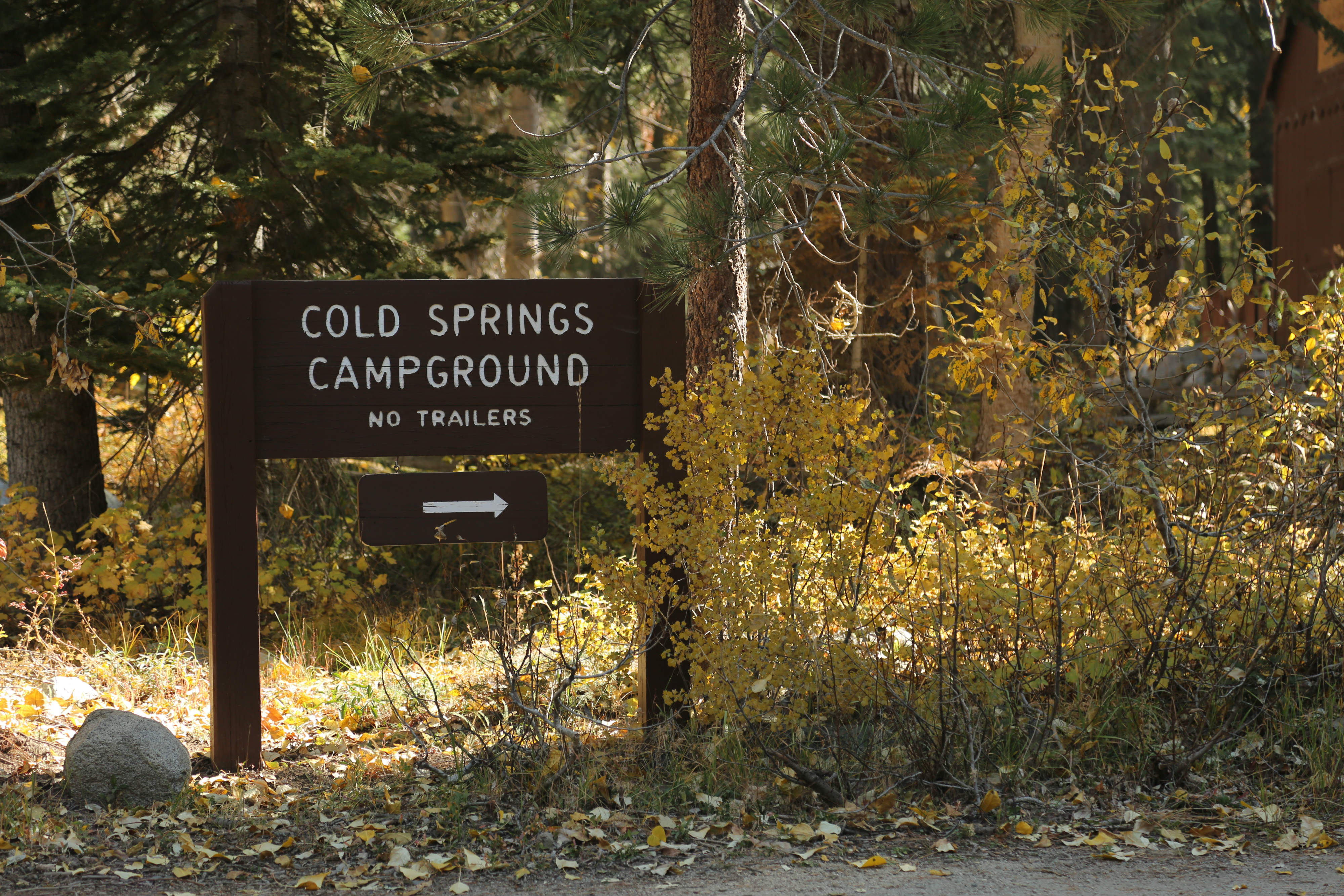
Reservations for Cold Springs Campground typically open in April and can be made up to one month in advance of your stay. All sites are reservation only.
Reservations for Crystal Springs Campground typically open in May and can be made up to two days in advance of your stay. All sites are reservation only.
Reservations for the Crystal Springs Group Campground typically open in January and can be made up to four months in advance of your stay. All sites are reservation only.
Dorst Creek Campground does not have a determined reopening date due to ongoing storm damage repair. Reservations for individual campsites at Dorst Creek Campground can be made up to one month in advance of your stay. Group site reservations can be made up to four months in advance. All sites are reservation only.
Lodgepole Campground reservations typically open in January and are available up to four months in advance of your stay. All sites are reservation only.
Moraine Campground does not have a determined reopening date due to ongoing road repairs. Reservations for Moraine Campground typically open in April and can be made up to one month in advance of your stay. All sites are reservation only.
Reservations for Sentinel Campground typically open in January and can be made up to four months in advance of your stay. All sites are reservation only.
Reservations for Sheep Creek Campground typically open in April and can be made up to one month in advance of your stay. All sites are reservation only.
Reservations for individual sites at Sunset Campground typically open in April and can be made up to one month in advance of your stay. Reservations for group campsites typically open in January and can be made up to four months in advance. All sites are reservation only.
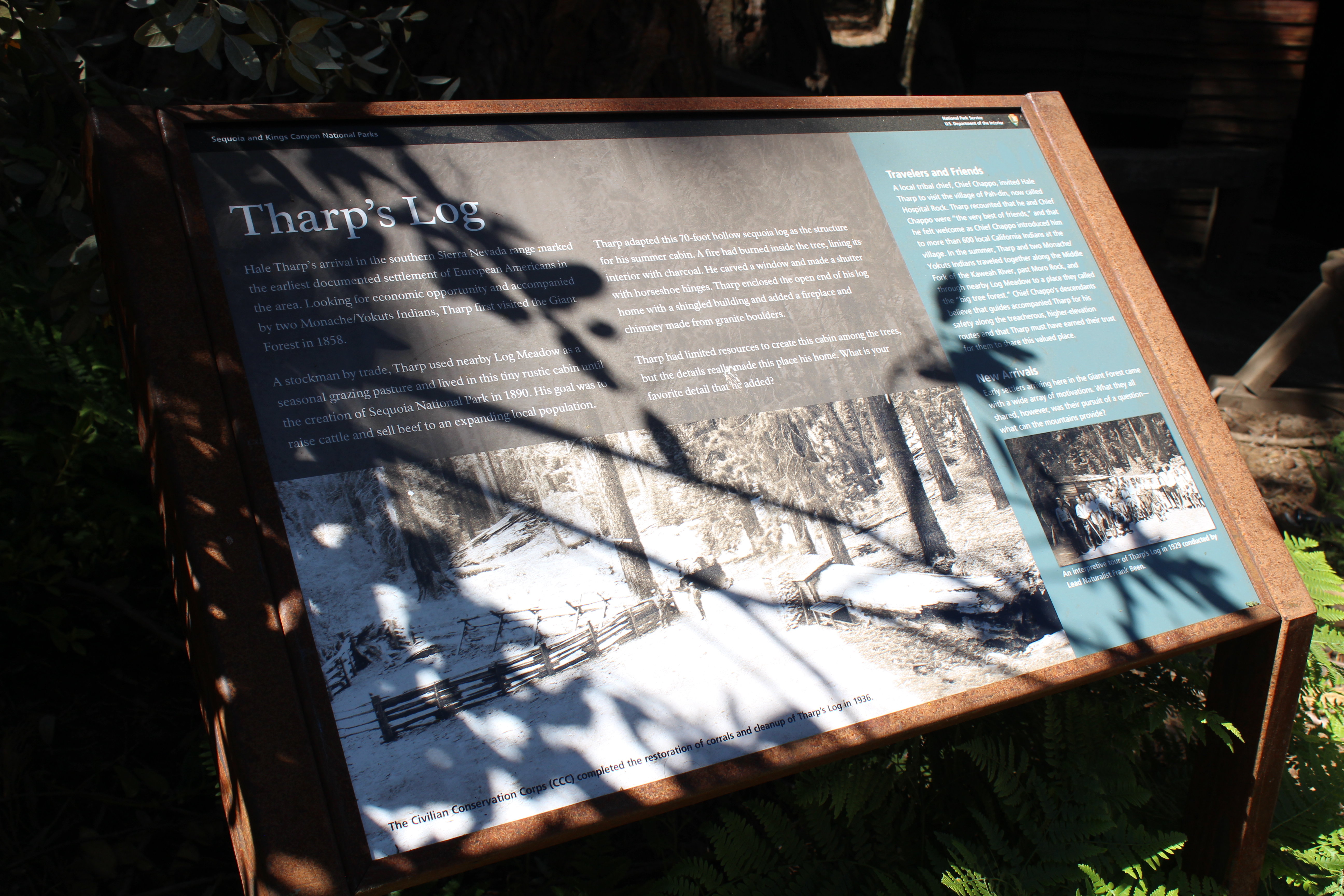
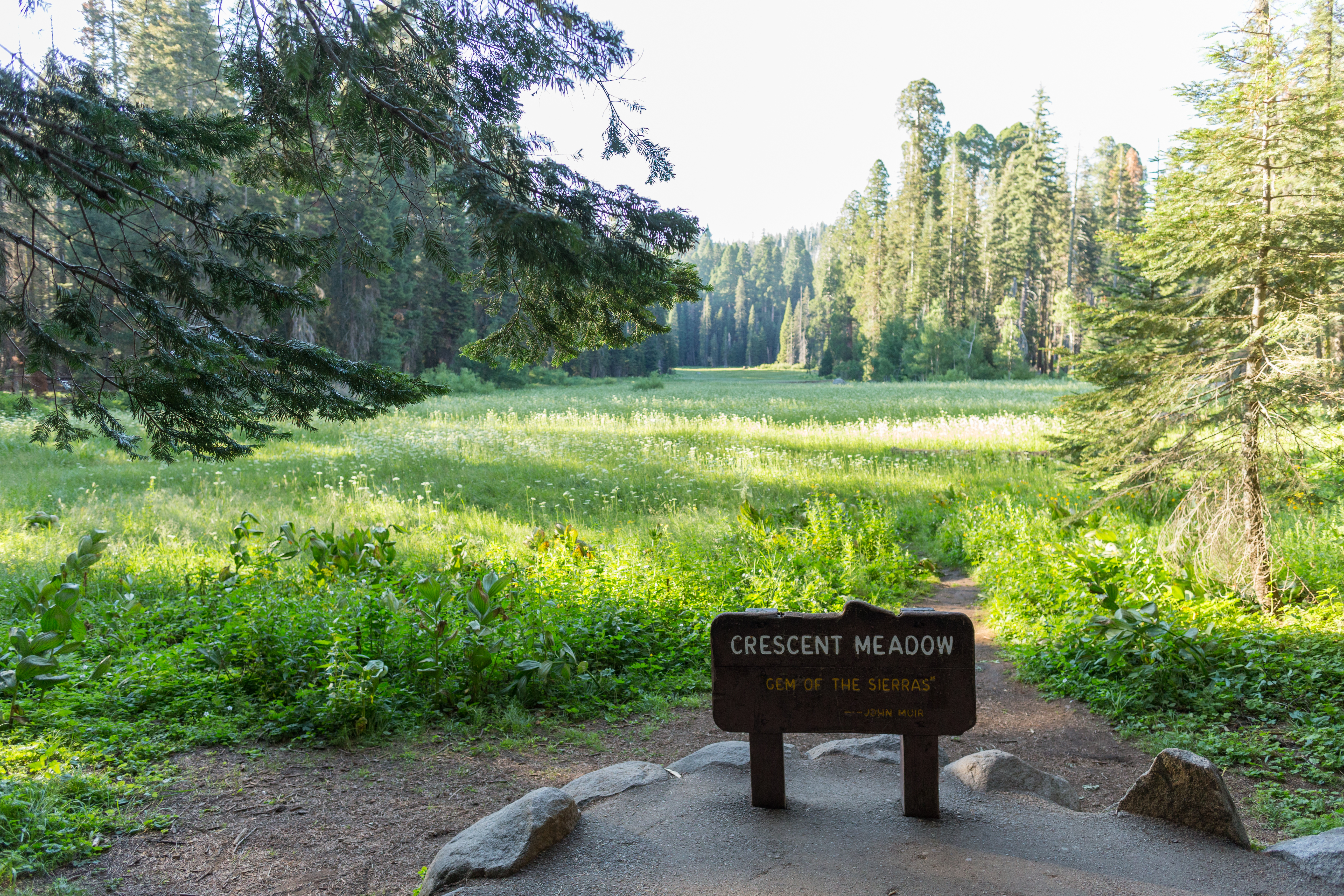
Before you is a low-profile wayside that is 36 X 24 inches. It has two rectangular pillars supporting the panel. The panel is made from oxidized metal. The sign is located next to Tharp's Log: a historic cabin near Crescent Meadow. Layout: The main image is a sepia-toned photograph of the cabin and corrals. The main text of the wayside blends into the top of the photograph. In a column to the right, there is text above a second, smaller, photograph. Title: Tharp's Log Main photo, description: a photo taken from far enough away to show the log, cabin, and corral. Two men stand next to the corral. Photo caption: The Civilian Conservation Corps (CCC) completed the restoration of corrals and cleanup of Tharp's Log in 1936. Main Text: Hale Tharp’s arrival in the southern Sierra Nevada range marked the earliest documented settlement of European Americans in the area. Looking for economic opportunity and accompanied by two Monache/Yokuts Indians, Tharp first visited the Giant Forest in 1858. A stockman by trade, Tharp used nearby Log Meadow as a seasonal grazing pasture and lived in this tiny rustic cabin until the creation of Sequoia National Park in 1890. His goal was to raise cattle and sell beef to an expanding local population. Tharp adapted this 70-foot hollow sequoia log as the structure for his summer cabin. A fire had burned inside the tree, lining its interior with charcoal. He carved a window and made a shutter with horseshoe hinges. Tharp enclosed the open end of his log home with a shingled building and added a fireplace and chimney made from granite boulders. Tharp had limited resources to create this cabin among the trees, but the details really made this place his home. What is your favorite detail that he added? Text, right-hand column, first section titled "Travelers and Friends": A local tribal chief, Chief Chappo, invited Hale Tharp to visit the village of Pah-din, now called Hospital Rock. Tharp recounted that he and Chief Chappo were “the very best of friends,” and that he felt welcome as Chief Chappo introduced him to more than 600 local California Indians at the village. In the summer, Tharp and two Monache/Yokuts Indians traveled together along the Middle Fork of the Kaweah River, past Moro Rock, and through nearby Log Meadow to a place they called the “big tree forest.” Chief Chappo’s descendants believe that guides accompanied Tharp for his safety along the treacherous, higher-elevation routes and that Tharp must have earned their trust for them to share this valued place. Text, right-hand column, second section titled "New Arrivals": Early settlers arriving here in the Giant Forest came with a wide array of motivations. What they all shared, however, was their pursuit of a question—what can the mountains provide? Right-hand column, photo description: A group of about twenty-five people in early-twentieth century dress stand in front of the cabin. Photo caption: An interpretive tour of Tharp's Log in 1929 conducted by Lead Naturalist Frank Been.
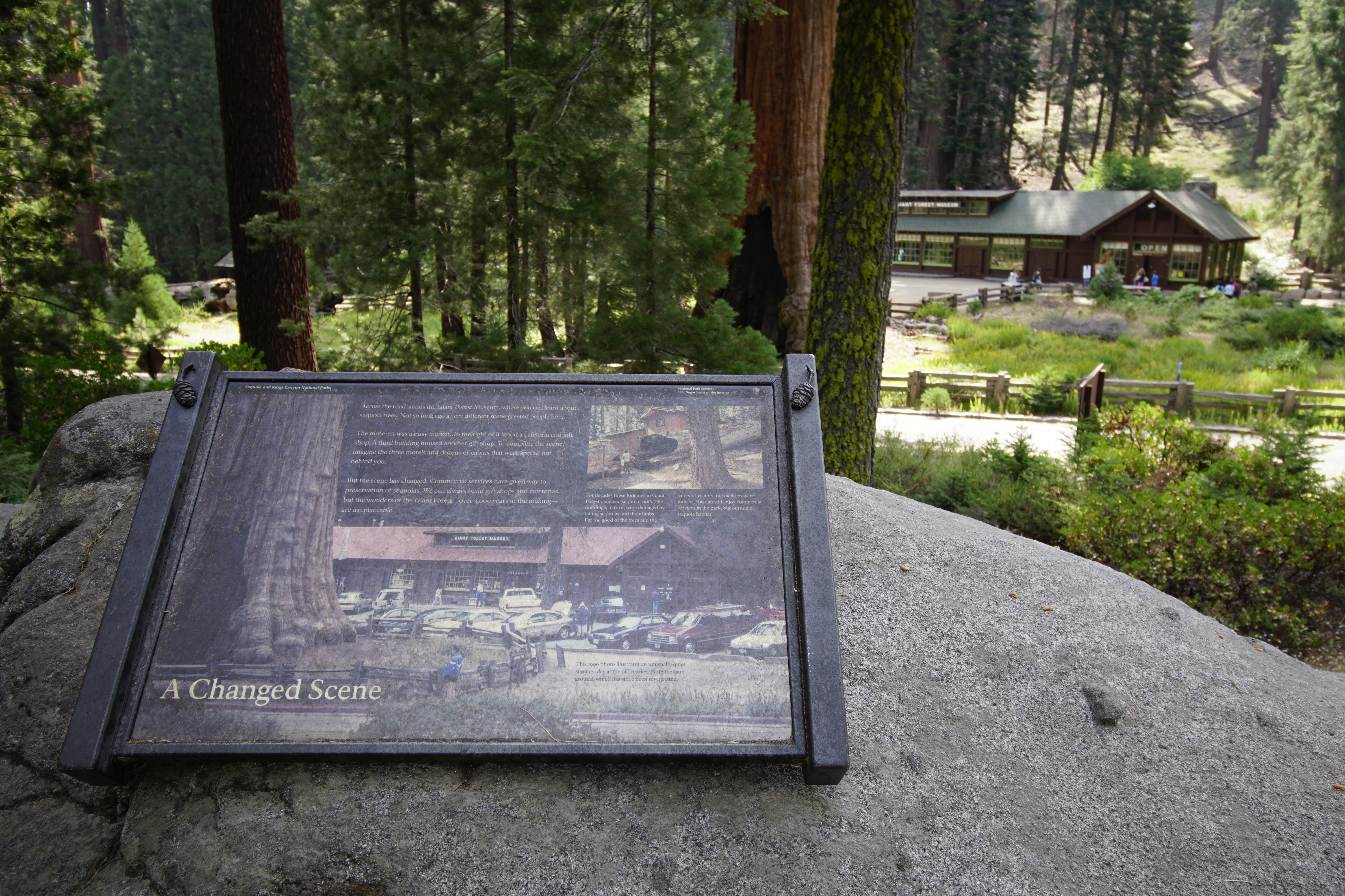
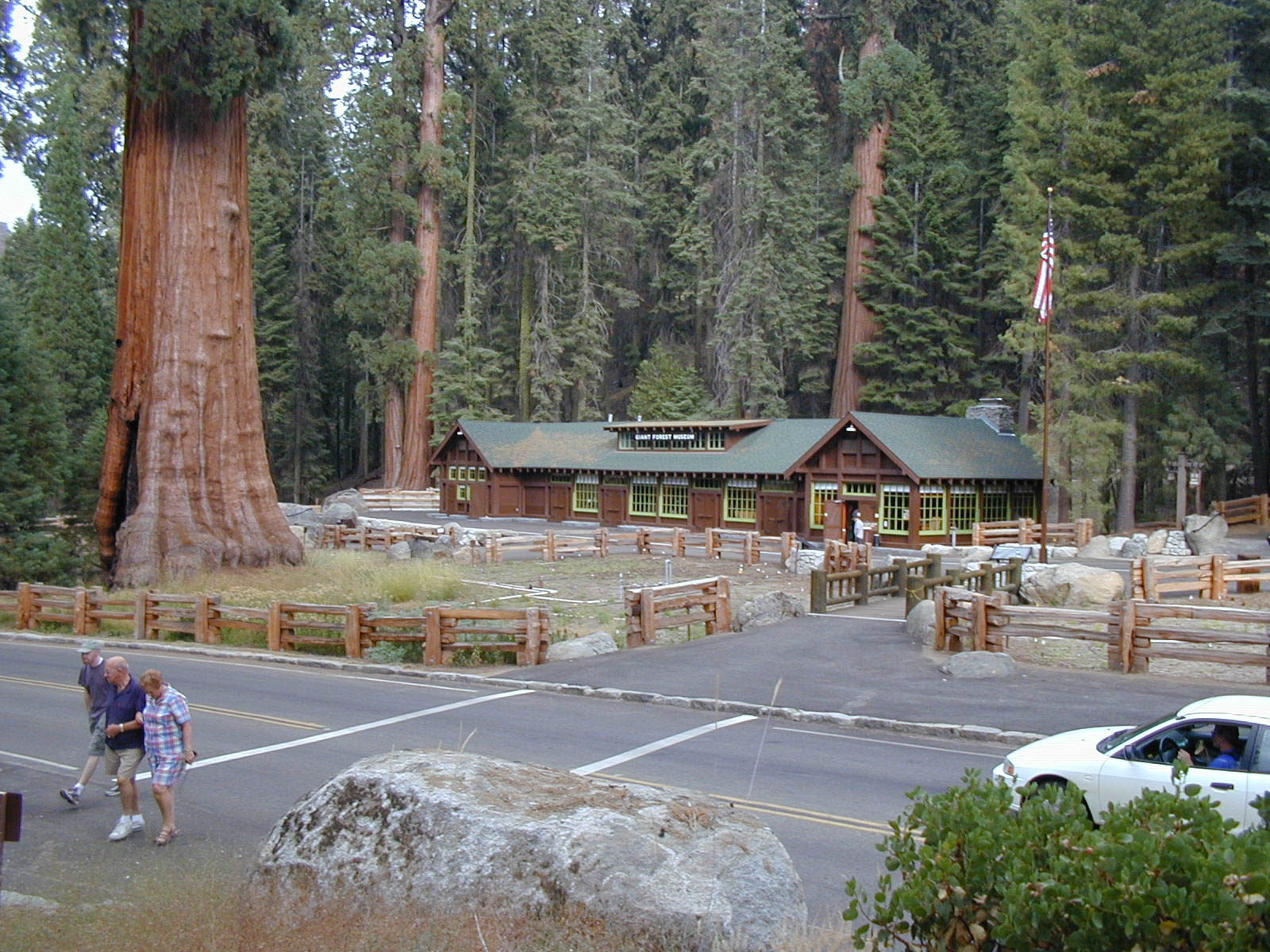
This wayside exhibit, titled "A Changed Scene," shows how the Giant Forest Museum area has changed over the years.
The View: You are surrounded by a rocky terrain, with low bushes and conifer trees. Down the hill and across the road is a massive giant sequoia with a deep black burn scar at the base. Beyond it is a single-story building with reddish brown planked wood siding and several multi-paned windows. Thick wooden beams and joists are visible. The building has a green peaked roof, and there is a paved pedestrian plaza in front of the building. On the panel is a closer photo of the view in front of you, except the building has a red peaked roof. A sign on the roof reads, "Giant Forest Market". A dozen 1990s-era cars are parked in front. The caption reads, "This 1996 photo illustrates an unusually quiet summer day at the old market. Note the bare ground, which has since been revegetated." The text reads, "Across the road stands the Giant Forest Museum, where you can learn about sequoia trees. Not so long ago a very different scene greeted people here. The museum was a busy market. To the right of it stood a cafeteria and gift shop. A third building housed another gift shop. To complete the scene, imagine the three motels and dozens of cabins that were spread out behind you. But the scene has changed. Commercial services have given way to preservation of sequoias. We can always build gift shops and cafeterias, but the wonders of the Giant Forest, over 3,000 years in the making are irreplaceable." A photo of a fallen sequoia log in front of a building with a person walking through a cutaway section of the trunk. The caption reads, "For decades these lodgings in the Giant Forest damaged sequoia roots. The buildings, in turn, were damaged by fallen sequoias and their limbs. For the good of the trees and the safety of visitors, the facilities were moved. You can still enjoy commercial services in the park, but outside of the sequoia habitat."
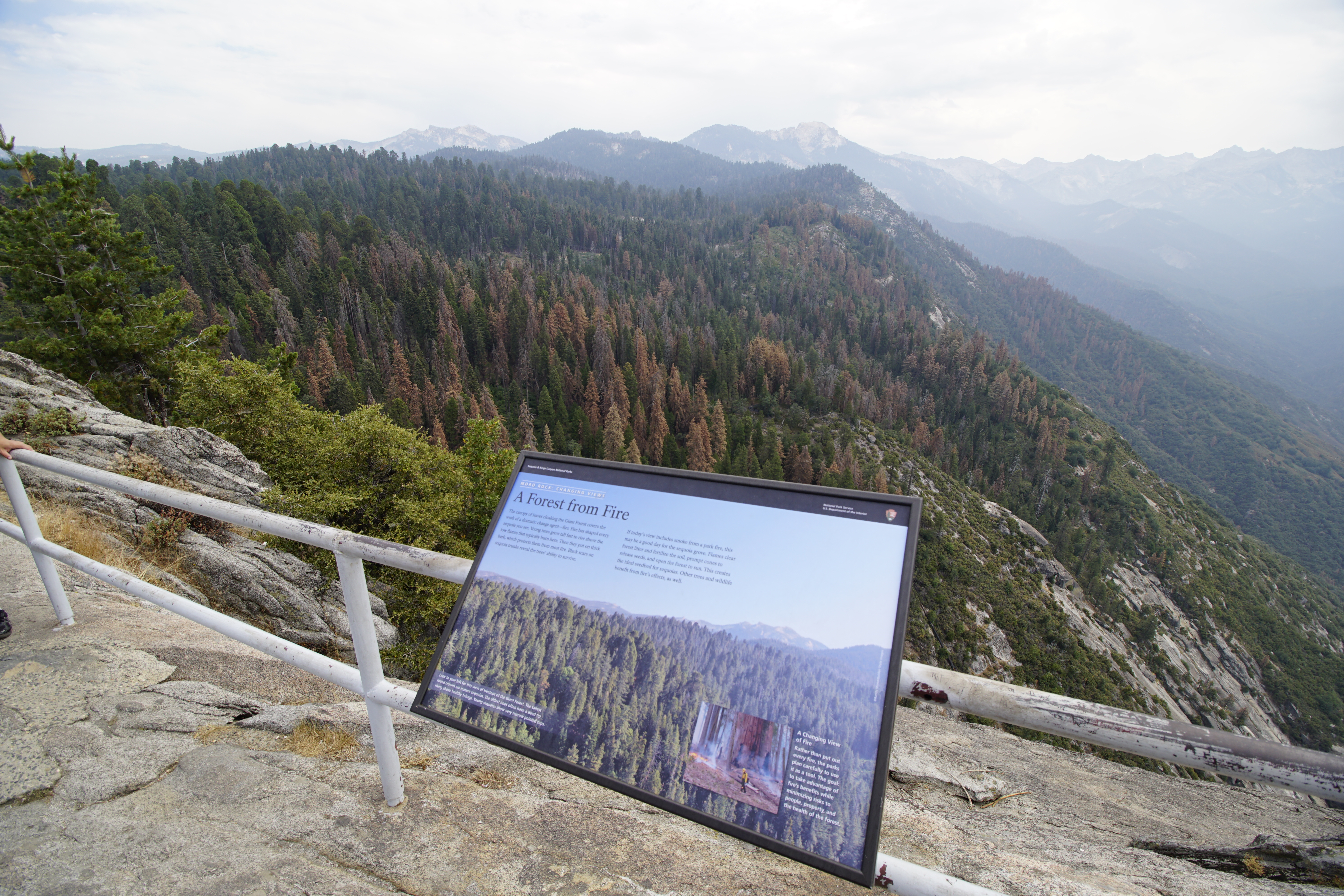
This wayside exhibit, titled "Moro Rock: Changing Views, A Forest from Fire," shows photos about the importance of fire.
The View: In front of you is a magnificent view of the forest below. From here you can see the varied sequoia treetops. The oldest often have a dead tip rising above the foliage. The tallest, are mature sequoias with a round crown. The narrow-pointed tops belong to younger sequoias. The text reads, The canopy of leaves cloaking the Giant Forest covers the work of a dramatic change agent- fire. Fire has shaped every sequoia you see. Young trees grow tall fast to rise above the low flames that typically burn here. Then they put on thick bark, which protects them from most fire. Black scars on sequoia trunks reveal the trees' ability to survive. If today's view includes smoke from the park fire, this may be a good day for the sequoias grove. Flames clear forest litter and fertilize the soil, prompt cones to release seeds, and open the forest to the sun. This creates the ideal seedbed for sequoias. Other trees and wildlife benefit from the fires affects, as well. A photo of your left view from this location shows a robust green forest with tree tops of various shapes and sizes. Mountain tops line the view in the distance. The caption reads, Look to your left for this view of treetops of the Giant Forest. The tallest round crowns are mature sequoias. The oldest ones often have a dead tip rising above healthy foliage. Young sequoias show very narrow pointed tops. An inset photo shows a park firefighter walking through patches of fire and billowing smoke, on the forest floor in a grove of Sequoia trees. He wears a backpack and a yellow helmet and shirt, and holds a metal canister with a flame coming out of the nozzle. The grove includes a very large sequoia trunk, with two large burn scars, almost 10 feet high. There are also a few fallen tree trunks, about one foot in diameter, and a few charred stumps. The caption reads, A changing of your fire Rather than put out every fire, the parks plan carefully to use it as a tool. The goal: to take advantage of fire's benefits while minimizing risk to people, property, and the health of the Forest.
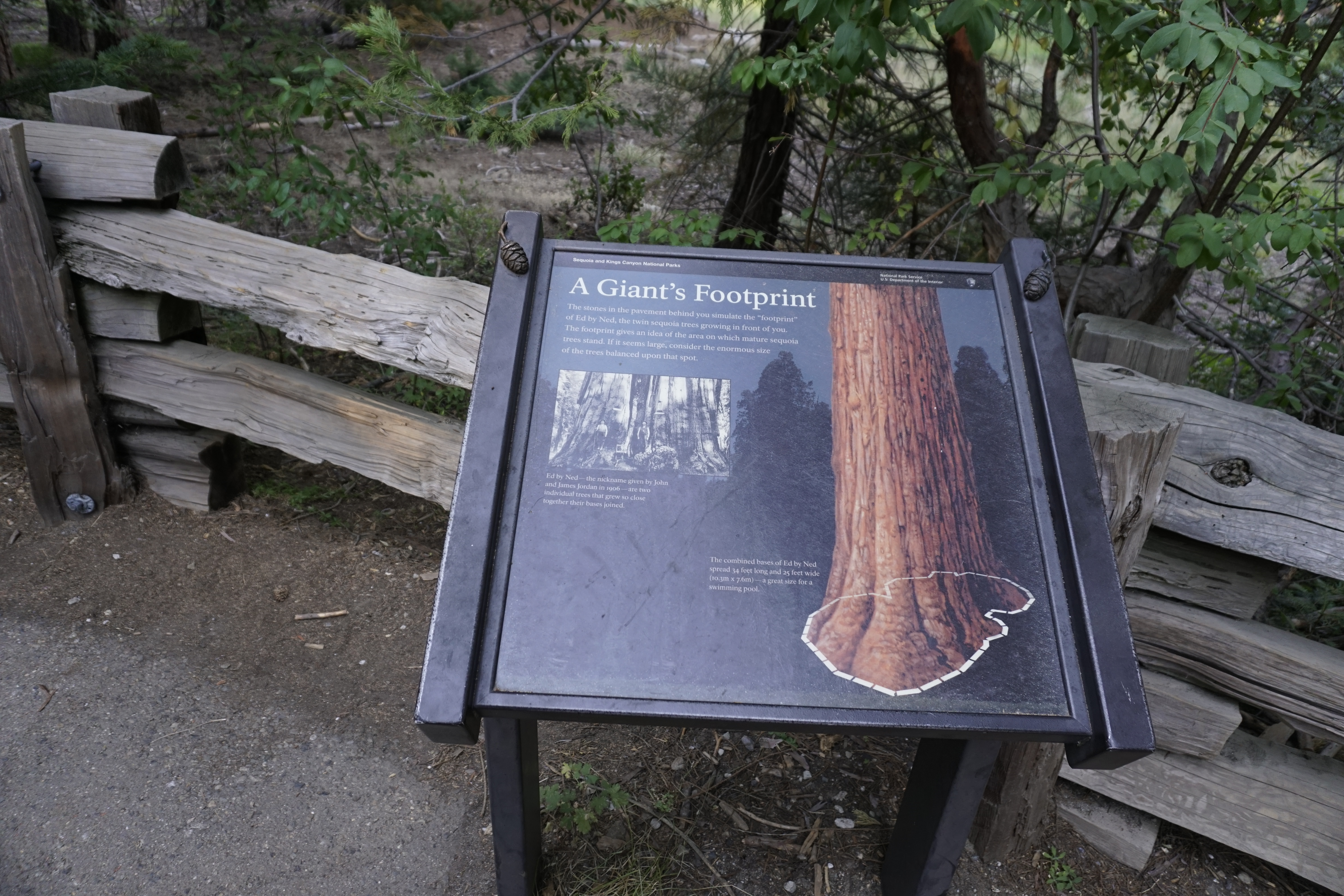
This wayside exhibit, titled "A Giant's Footprint", shows the size of a mature sequoia tree's cross section.
The View: To your left are the grasses of Round Meadow and to your right are the sequoias of Giant Forest. In front of this exhibit are two giant sequoias that have grown together. On the trail, adjacent to this exhibit, grey rectangular bricks fill an outline mirroring the base of those sequoias. Take a walk along the edge of that outline to see how immense these trees are. The text on the panel reads, A Giant's Footprint The stones in the pavement behind you simulate the "footprint" of Ed by Ned, the twin sequoia trees growing in front of you. The footprint gives an idea of the area on which mature sequoia trees stand. If it seems large, consider the enormous size of the tree balanced upon that spot. A black and white photo of two joined sequoia trees trunks. At twelve feet high on the trunks, on either side of the joint, are wooden signs. Below each sign stands a man, wearing a vest and hat. The caption reads, Ed by Ned, the nickname given by John and James Jordan in 1906, are two individual trees that grew so close together their bases joined. An illustration of the two joined sequoia trunks, with a white dashed outline showing the shape made by their combined bases. The caption reads, The combined bases of Ed by Ned spread 34 feet long and 25 feet wide (or 10.3 m by 7.6 m) a great size for a swimming pool.
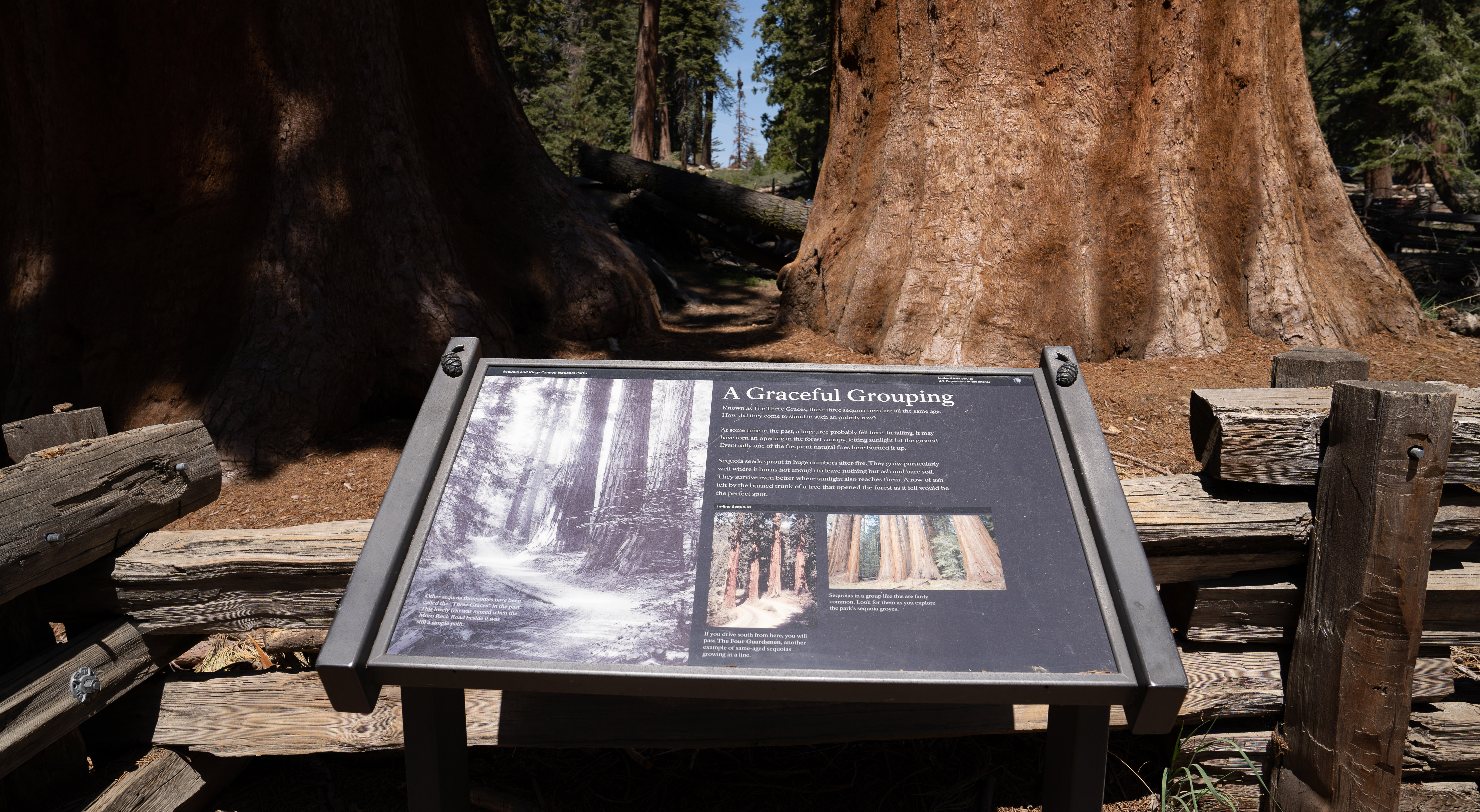
This wayside exhibit, titled "A Graceful Grouping", shows three sequoia trees.
The View: In front of this exhibit are three giant sequoia trees. Their massive trunks stand side by side, in a row. On the upper corners of this wayside exhibit frame are tactile sequoia cones made of brass. The cones are about the size of an egg, with a small twig attached to each. The cones have been flattened on the bottom to help secure them to the frames. Many wayside exhibits in the Giant Forest have similar brass cones. The text reads, A Graceful Grouping Known as The Three Graces, these three sequoia trees are all the same age. How did they come to stand in such an orderly row? At some time in the past, a large tree probably fell here. In falling, it may have torn an opening in the forest canopy, letting sunlight hit the ground. Eventually one of the frequent natural fires here burned it up. Sequoia seeds sprout in huge numbers after fire. They grow particularly well where it burns hot enough to leave nothing but ash and bare soil. They survive even better where sunlight also reaches them. A row of ash left by the burned trunk of a tree that opened the forest as it fell would be the perfect spot. A black and white photo shows three giant sequoias, touched by shafts of sunlight that also illuminate the dirt road beside them. The caption reads, Other sequoia threesomes have been called the "Three Graces" in the past. This lovely trio was named when the Moro Rock Road beside it was still a simple path. Two photos of other in line Sequoias. A photo of four sequoias in a line with two dirt roads, each of which runs in between the trees on the left side of the grouping. The caption reads, If you drive south from here, you will pass The Four Guardsmen, another example of same aged sequoias growing in a line. The second photo shows a line of giant sequoia trunks in groupings of three and four with a single trunk to the right. The caption reads, Sequoias in a group like this are fairly common. Look for them as you explore the park's sequoia groves.
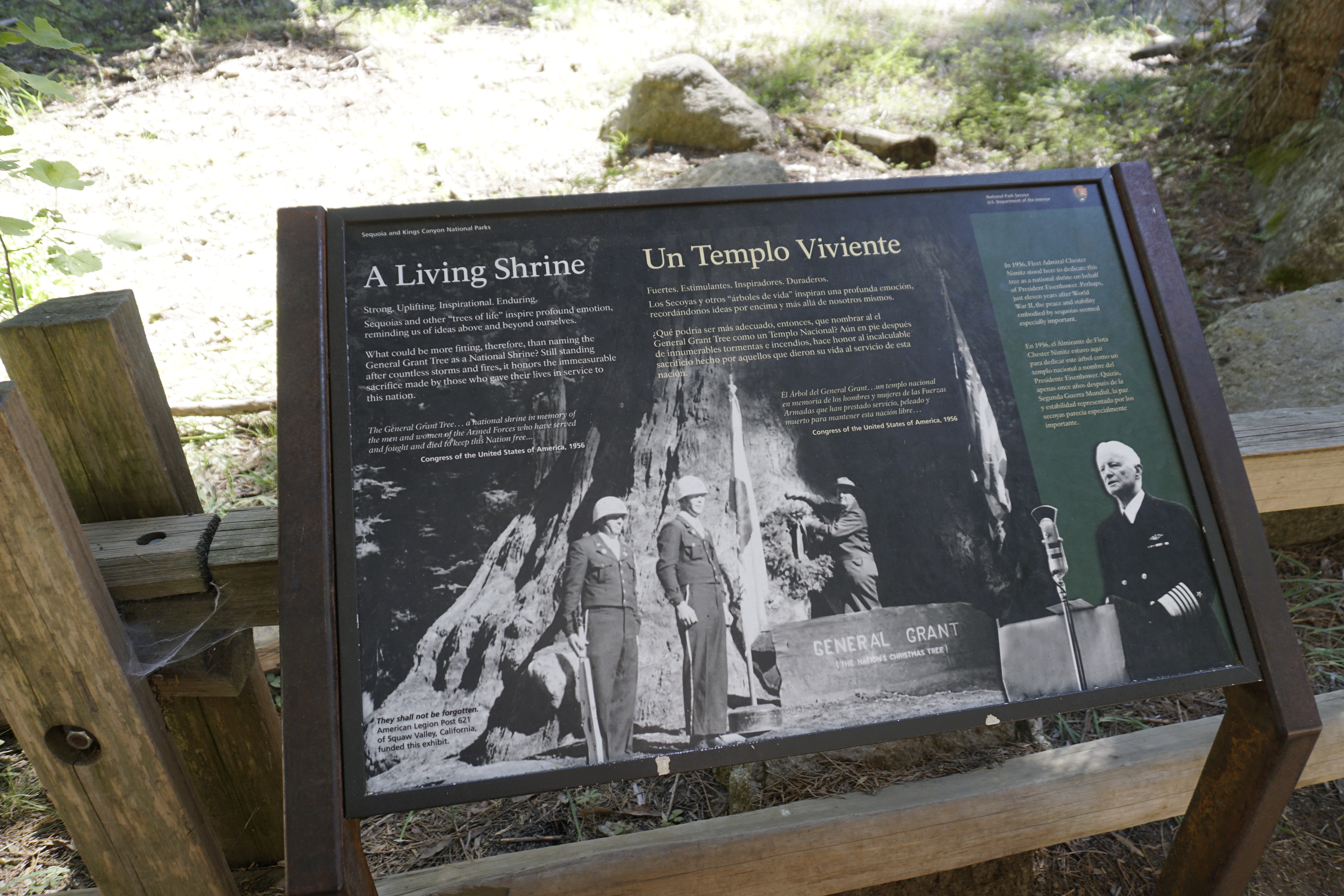
Some national parks exist to commemorate battles. No known battle took place here, yet this giant tree inspires us to consider the inner strength and endurance of this country and those who have fought for it. What do you feel about the unusual move of designating a tree as a national shrine?
This wayside exhibit, titled "A Living Shrine", shows black and white photos, and text about honoring those who have fought for this country. A photo of a ceremony at the General Grant Tree. A man wearing a park ranger hat and uniform is attaching a large decorated wreath with a bow to the tree's trunk. A flag of the State of California drapes down around a flagpole. Two other men stand stiffly at attention, wearing round helmets and dark colored uniforms. One of them is holding a rifle at his side. Their waist length jackets have light colored insignia and buttons. and their trousers have a stripe down the side. A wooden sign mounted on a base next to the tree reads, General Grant Tree. The Nation's Christmas Tree. The text reads, Strong. Uplifting. Inspirational. Enduring. Sequoias and other "trees of life" inspire profound emotion, reminding us of ideas above and beyond ourselves. What could be more fitting, therefore, than naming the General Grant Tree as a National Shrine? Still standing after countless storms and fires, it honors the immeasurable sacrifice made by those who gave their lives in service to the nation. A quote from the Congress of the United States of America in 1956. "The General Grant Tree...a national shrine in memory of the men and women of the Armed Forces who have served and fought and died to keep this Nation free..." A photo shows a man making a speech. He is elderly, with short white hair and dressed in a dark uniform, with a small winged insignia and bar of striped ribbons on the jacket pocket. At the cuff of the jacket sleeve is a light colored wide band with four smaller bands going up the arm, and an appliqued star near the elbow. He is standing behind a podium with a piece of paper on it, and is facing a shiny, old fashioned microphone, that is shaped like an upright pill, with a fan shaped arc above it. An American flag, hangs on a pole, next to the podium. The text reads, In 1956, Fleet Admiral Chester Nimitz stood here to dedicate this tree as a national shrine on behalf of President Eisenhower. Perhaps, just eleven years after World War II, the peace and stability embodied by sequoias seemed especially important.
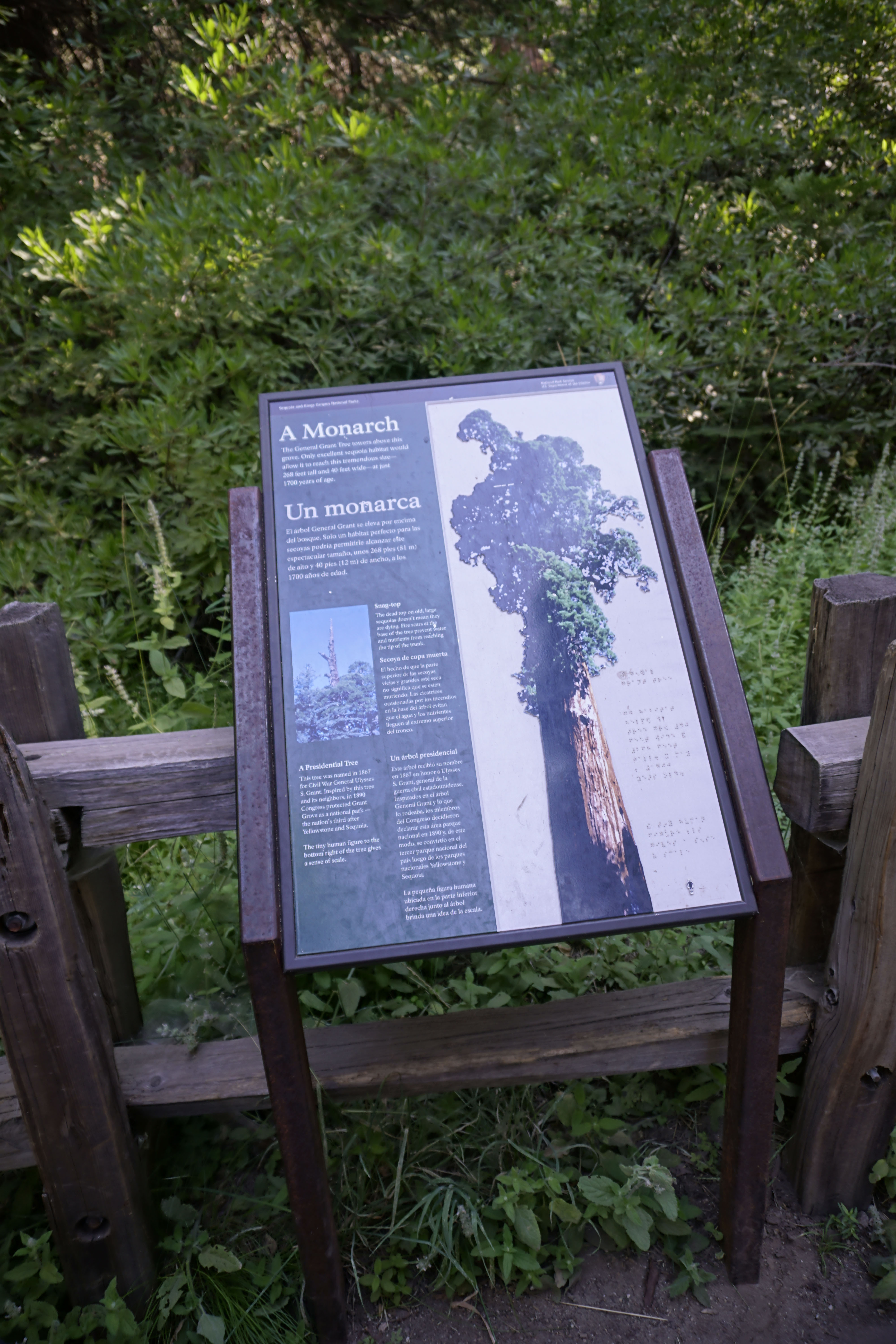
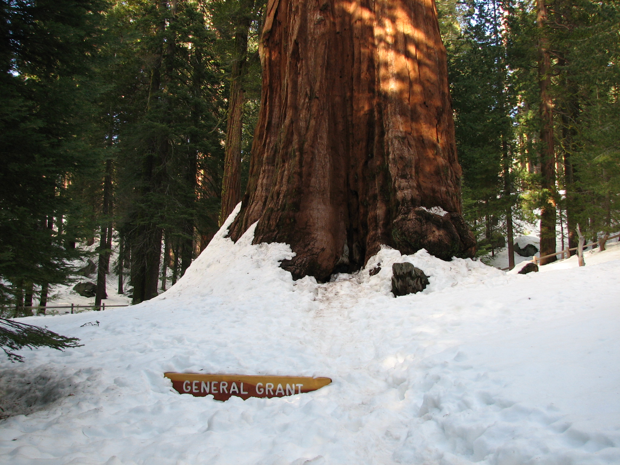
This tactile exhibit shows the size of the General Grant Tree compared to a person, and discusses its significance.
The View: Before you is a view of almost the entire General Grant tree, the second largest sequoia in the world. Its thick trunk and immense mass dwarf the magnificent giant sequoias surrounding it. This exhibit has a photo and text on the left side. On the right side is a recessed rectangle with tactile images of a giant sequoia, and a person next to it, in scale. The main text reads, A Monarch The General Grant Tree towers above the grove. Only excellent sequoia habitat would allow it to reach this tremendous size - 268 feet tall and 40 feet wide - at just 1700 years of age. Below the text is a photo of the dead, bare top of a sequoia trunk that sticks up taller than the tops of its surrounding branches, which have full green foliage. The text reads, The dead top on old large sequoias doesn't mean they are dying. Fire scars at the base of the tree prevent water and nutrients from reaching the tip of the trunk. On the right side of the exhibit, you can feel the outlined shapes, and compare the sizes of, a giant sequoia and a tiny human figure next to it, in the bottom right corner. The text reads, A Presidential Tree This tree was named in 1867 for Civil War General Ulysses S. Grant. Inspired by this tree and its neighbors, in 1890 Congress protected Grant Grove as a national park - the nation's third after Yellowstone and Sequoia. The tiny human figure, to the bottom right of the tree, gives a sense of scale. The Braille information provided on this exhibit has already been explained in this Audio Description.
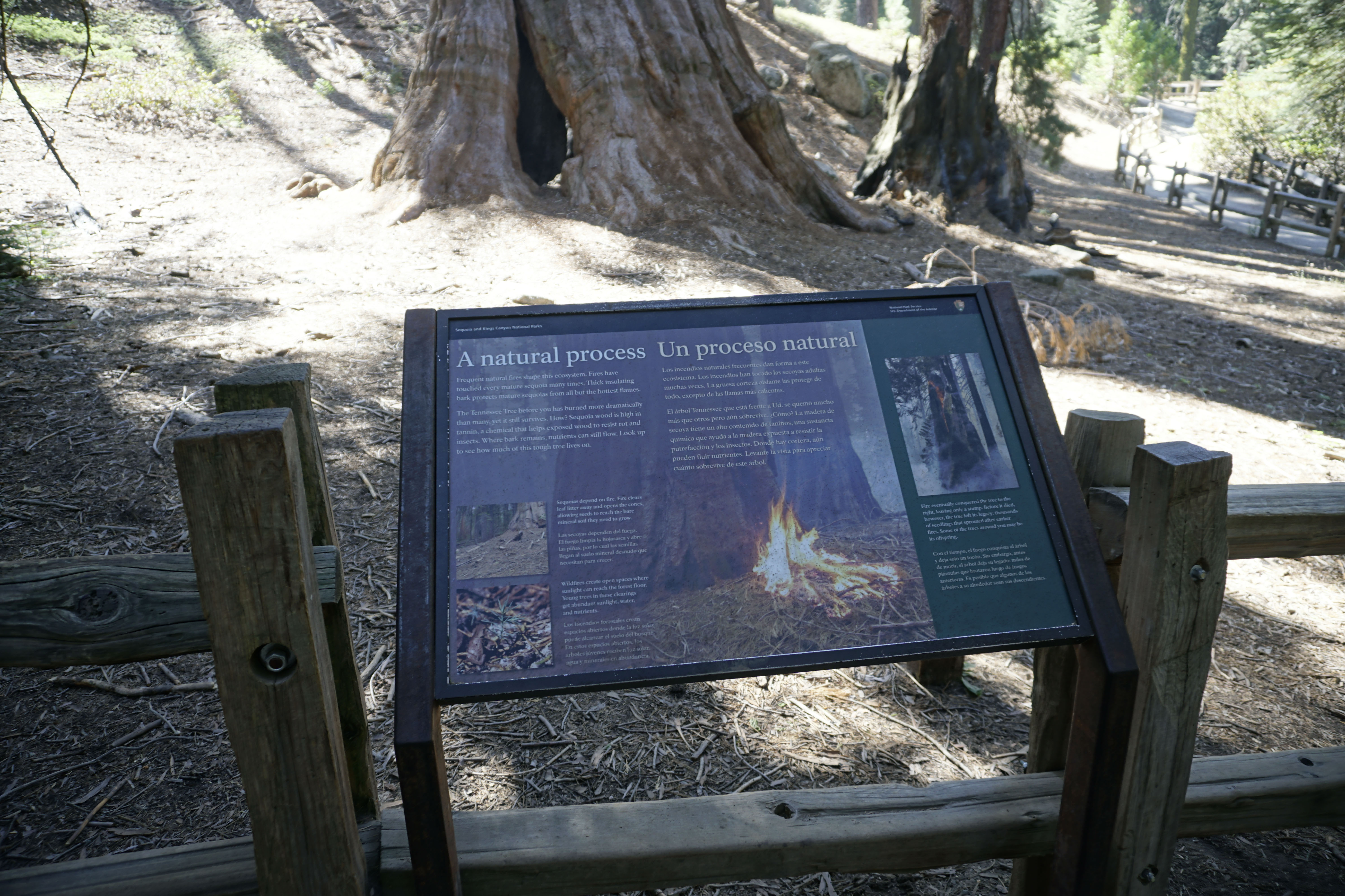
This exhibit, titled "A Natural Process," shows how fire plays a part of sequoia growth.
The View: About 20 feet in front of you is a large sequoia tree. The center of its base has been hollowed by fire, leaving little wood to support the tree. A charred tree stump is next to it. A photo of a fire burning near the base of a sequoia tree. The text reads, A Natural Process Frequent natural fires shape this ecosystem. Fires have touched every mature sequoia many times. Thick insulating bark protects mature sequoias from all but the hottest flames. The Tennessee Tree before you has burned more dramatically than many, yet it still survives. How? Sequoia wood is high in tannin, a chemical that helps exposed wood to resist rot and insects. Where bark remains, nutrients can still flow. Look up to see how much of this tough tree lives on. A photo shows the ground next to a sequoia tree trunk. It is thickly covered with pine needles and small branches. The text reads, Sequoias depend on fire. Fire clears leaf litter away and opens the cones, allowing seeds to reach the bare mineral soil they need to grow. A photo shows a bright green young seedling sprouting up from darkened soil with patches of white ash. The text reads, Wildfires create open spaces where sunlight can reach the forest floor. Young trees in these clearings get abundant sunlight, water, and nutrients. On the right side of this exhibit is a photo of a sequoia tree trunk, engulfed in flames. Smoke billows around the tree. The text reads, Fire eventually conquered the tree to the right, leaving only a stump. Before it died, however, the tree left its legacy: thousands of seedlings that sprouted after earlier fires. Some of the trees around you may be its offspring.
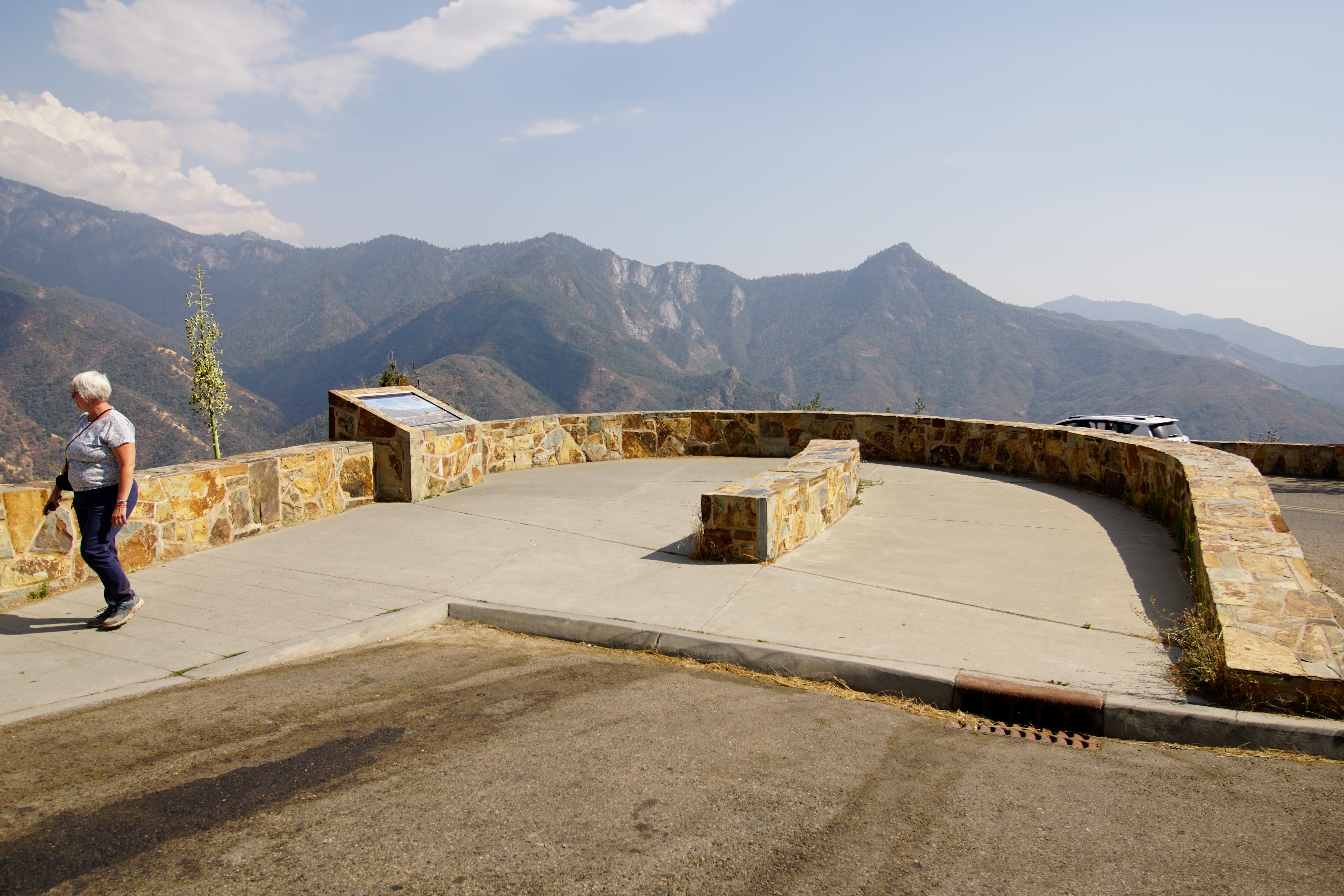
Located on the Generals Highway between Hospital Rock Picnic Area and the Giant Forest Museum, this viewpoint offers stunning views of Moro Rock and the steep elevation change from the foothills to granite peaks. The foothills are an often overlooked area of the park, but they are a vital and diverse landscape. During the cooler months, deer and bears often move downhill to find food. Reptiles, birds, and small mammals live there year round. It is not uncommon to spot foxes i
This wayside exhibit, titled "Protecting Wildlife", shows photos and text. The text reads, An amazing range in elevation, from 1,359 feet (or 411 meters) to 14,494 feet (or 4,417 m), makes these parks extraordinary. The diversity in elevation results in a huge variety of plants and animals. Their habitats range from low, hot foothills to evergreen conifer forests to cold alpine peaks. Biodiversity, the variety of life, is protected in these parks for you and future generations to enjoy and study. A photo of the view in front of you. Rounded foothills in the foreground covered with trees and shrubs. Higher up, conifer forests. Even higher, in the distance, snowy peaks. The photo identifies three habitat zones: Alpine Zone. Mount Eisen. 12,160 feet (or 3,706 m). Castle Rocks. 9,180 feet (or 2,798 m). Conifer Zone. Giant Forest. 6,500 feet (or 2,000 m). Moro Rock. 6,725 feet (or 2,050 m). Milk Ranch Peak. 6,250 feet (or 1,905 m). Foothills Zone. Amphitheater Point. 4,390 feet (or 1,337 m). You are here. The text identifies three animals are shown for each habitat zone: Alpine Animals: adapted to high, snowy peaks. Photo of a gray-crowned rosy finch. The bird is rosy pink with gray wingtips, tail, and head. A photo of a pika, a small tan furry animal shaped like a little rabbit, except with small oval ears. A photo of a mountain yellow-legged frog with bulging round eyes and a wide mouth. Its skin is bumpy and tan, except for its belly and inner legs, which are bright yellow. The text reads, Conifer Forest Animals: Adapted to cool, moist woods. A photo of a white-headed woodpecker with a red patch on the crown. Its wings are black with long white feathers at the edges. A photo of a pine marten. This tan furry animal has a pointy black nose with long whiskers and oval-shaped upright ears. A photo of the non-venomous mountain kingsnake. Its body is circled with repeating bands of red, black and white. The text reads, Foothill Animals: adapted to dry, hot summers. A photo of a California quail. The bird's head is black with white streaks, and has a black top knot that curves forward. Its body is plump and round. A photo of the venomous western rattlesnake. It has a broad, bluntly triangular head. Its upper body is light tan, with brown blotches. Its lower body is banded with stripes. A photo of a gray fox, like a dog with a fluffy tail. The fur on its chin and neck is white, and its shoulders and chest are red.
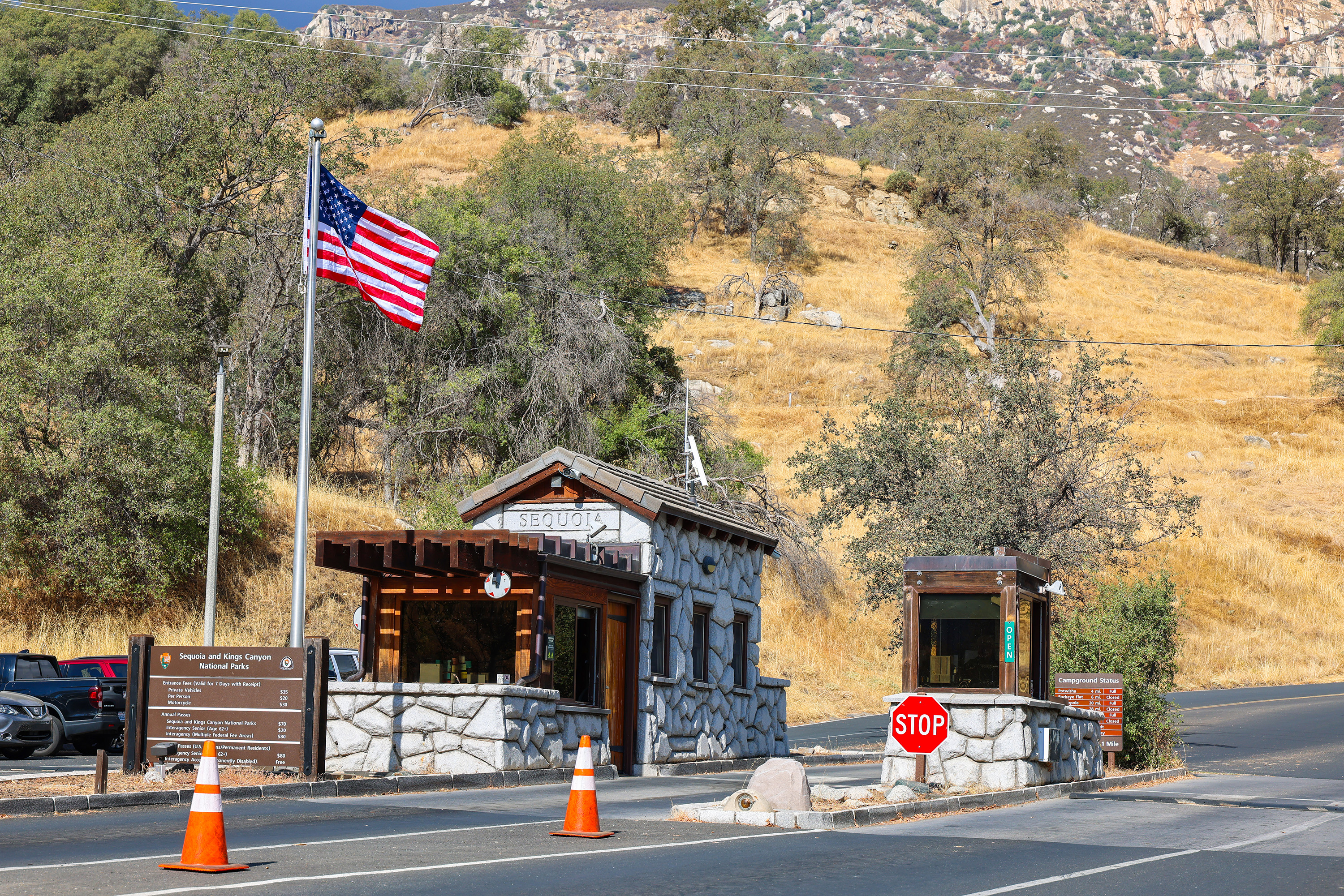
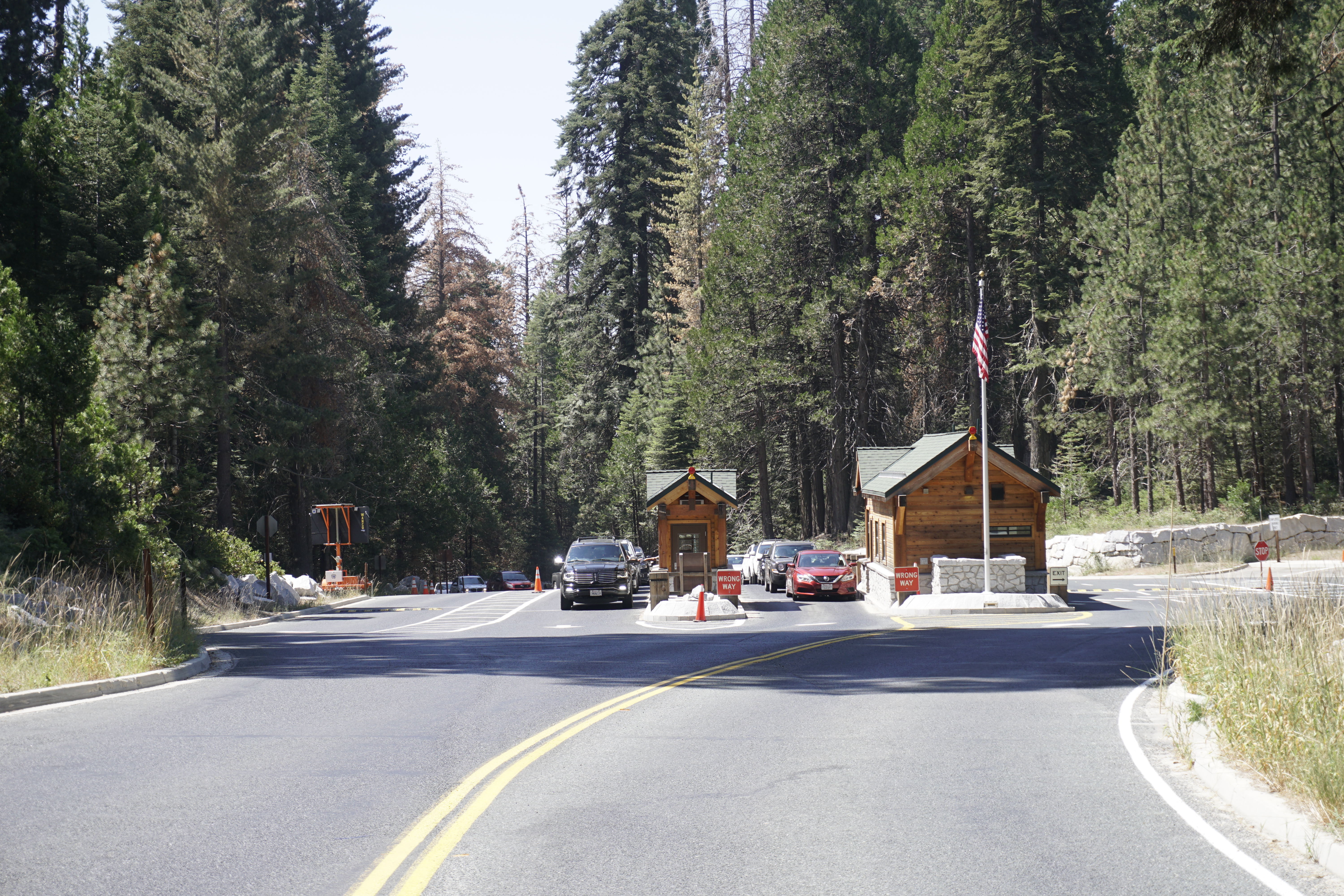
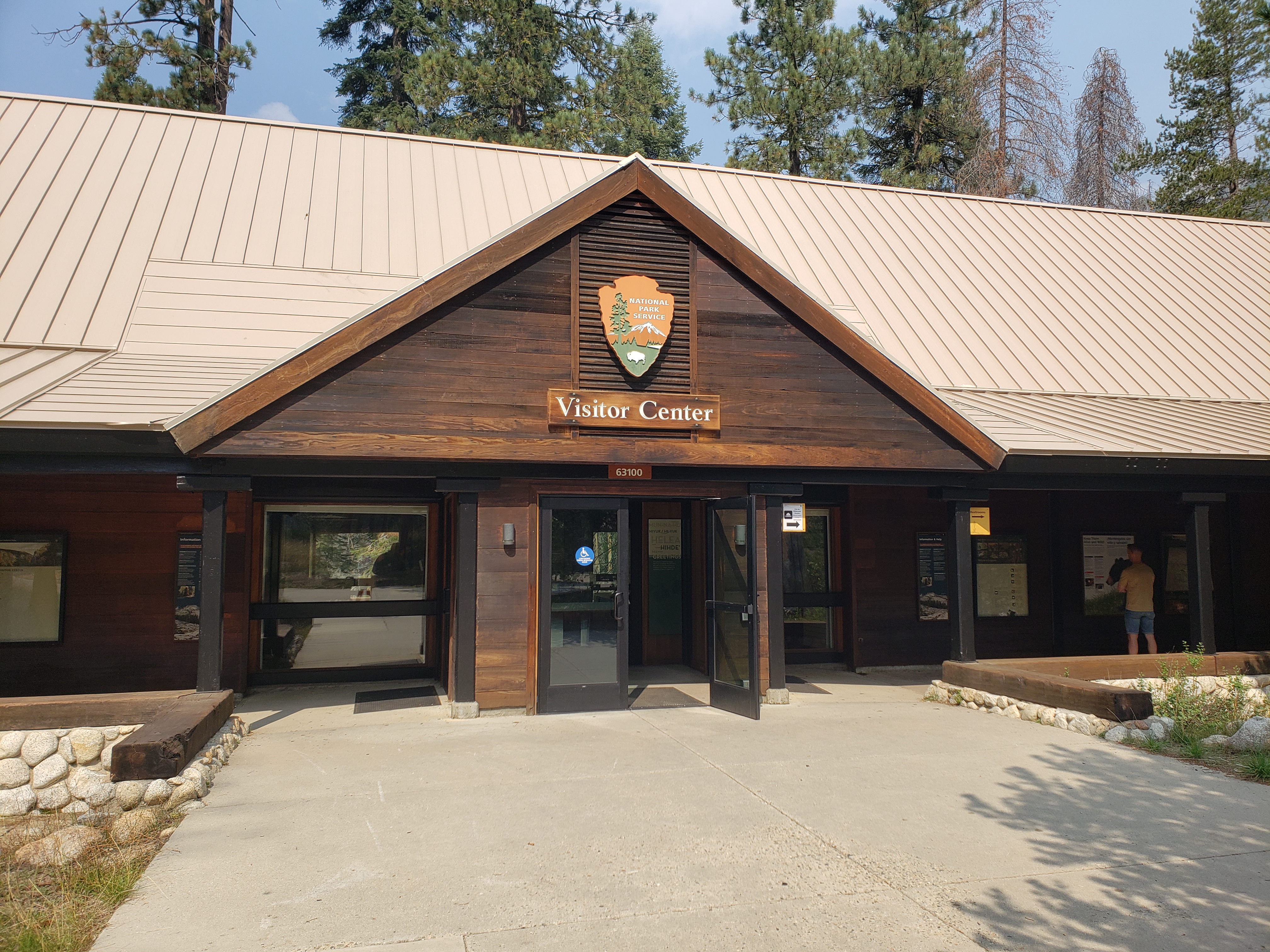
Visitors pay the entrance fee or use an interagency pass at the station. Entrances station staff provide a park newspaper and other orientation materials.
The landscape surrounding Ash Mountain Entrance Station is rolling hills, covered with scattered brush and small trees, including blue oaks and buckeyes. Ahead, you can see a rocky mountain top. Here, at the entrance station, the road widens from a two-lane road, into a four lane road, with two heading uphill. On the downhill, or exit side of the road, is a small parking lot. Separating the exit side of the road from the uphill, or entrance, side is a median with a one-story entrance structure, a pole flying the United States flag, and a red stop sign. The entrance station is made of pale grey stone cobbles, with brown wood framed windows, a reddish-brown wood plank eave, and thick brown wooden roof rafters. The word "Sequoia" is carved into the stone in capital letters near the top of the building. An extension of this building looks like an enclosed porch. The bottom two or three feet are made of the same stone as the on the main building, but the upper half is made of reddish brown plank wood. Thick wooden rafters support the roof and stick out, shading part of the building. Windows adjacent to the entrance and exit lanes may be open so that park staff can assist drivers. Signs provide information about fees, vacancies, and safety. Separating the two entrance lanes is a second structure that is much smaller, about the size of a toll booth. It also has a stone base, with a wood plank structure above, and windows open to the car lanes. As you drive up to enter the park, outside the main building, a rectangular wood plank sign reads, "Sequoia and Kings Canyon National Parks Entrance fees. Just past the entrance station is a sign with current campground status information about occupancy.
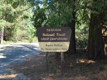
Please consult the USFS on facility availability- https://www.fs.usda.gov/recarea/sequoia/recarea/?recid=79580.Aspen Hollow Group Campground sits at an elevation of 5,300 feet within the Giant Sequoia National Monument, adjacent to Kings Canyon National Park. The campground is one mile from Hume Lake, an 87-acre man-made lake in the Kings River Watershed. The campground accommodates up to 100 people and has back-in spaces for 35 vehicles. Vault toilets, drinking water, laundr
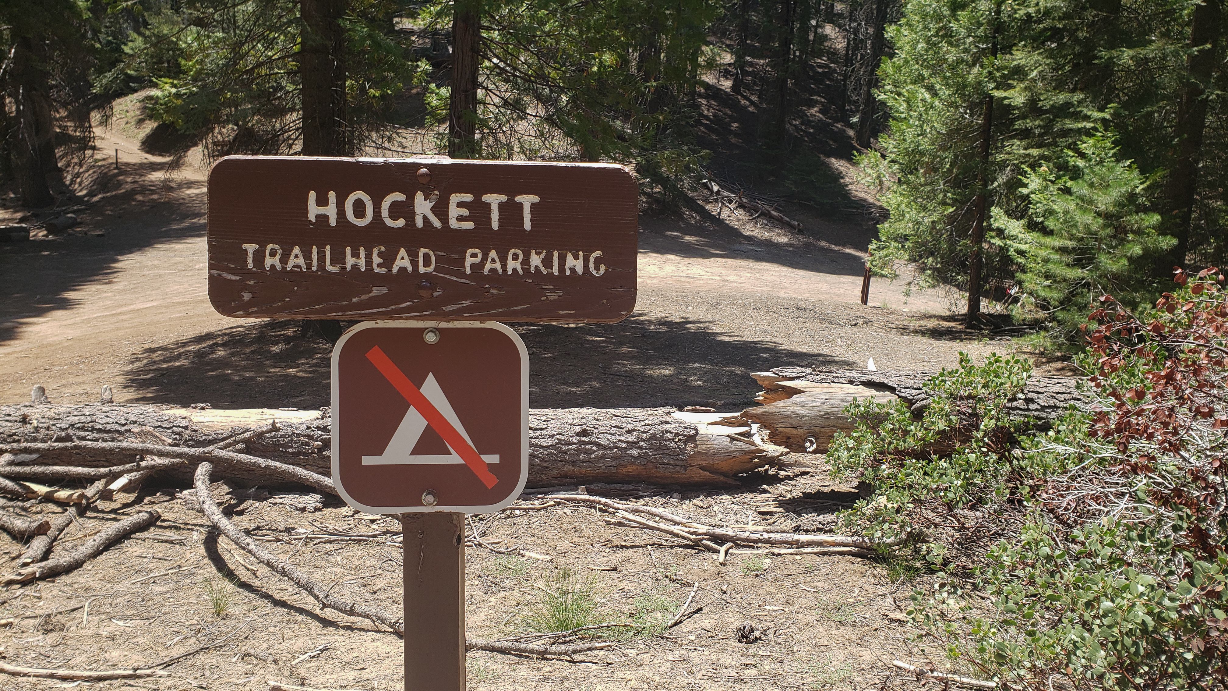
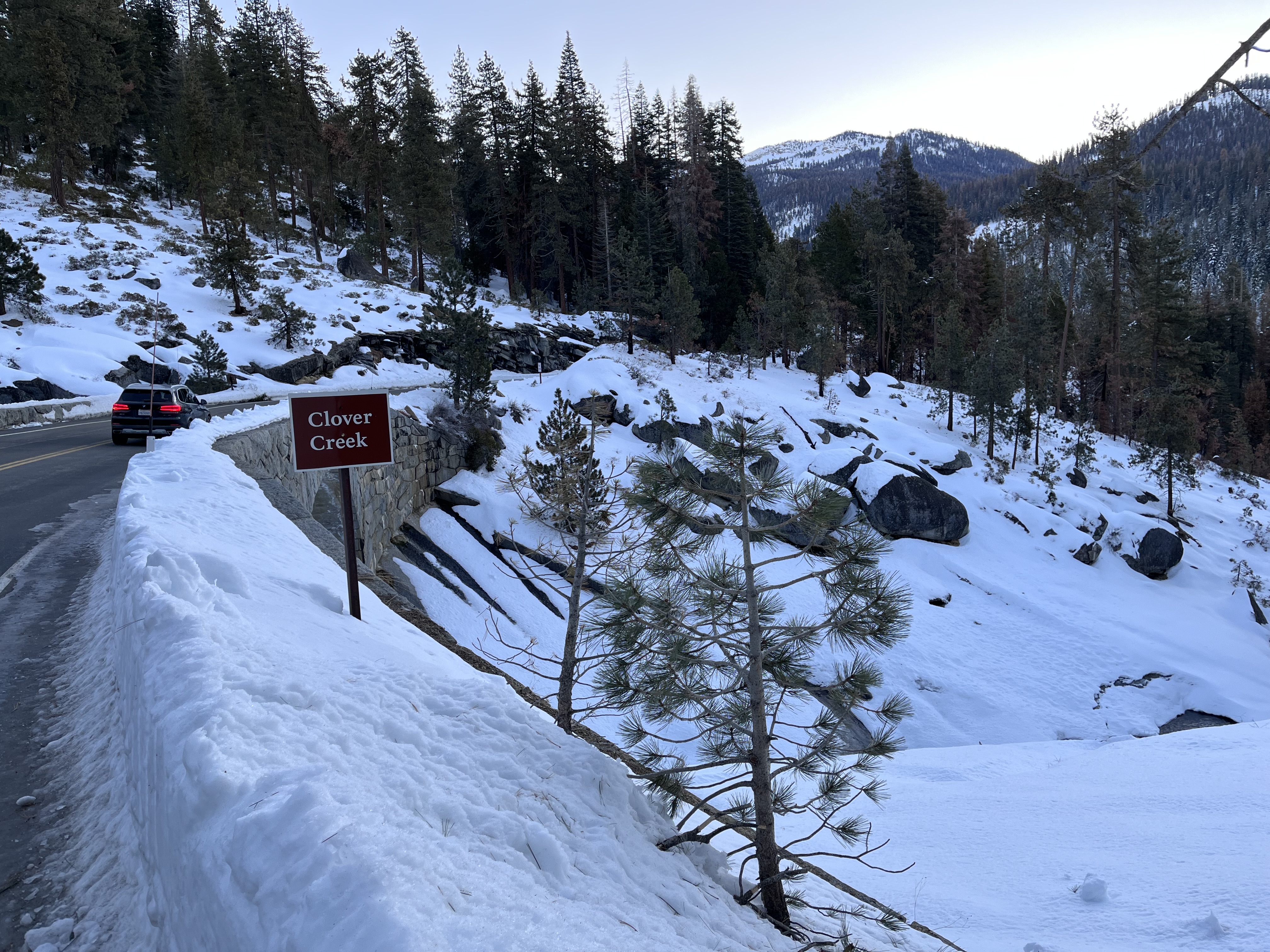
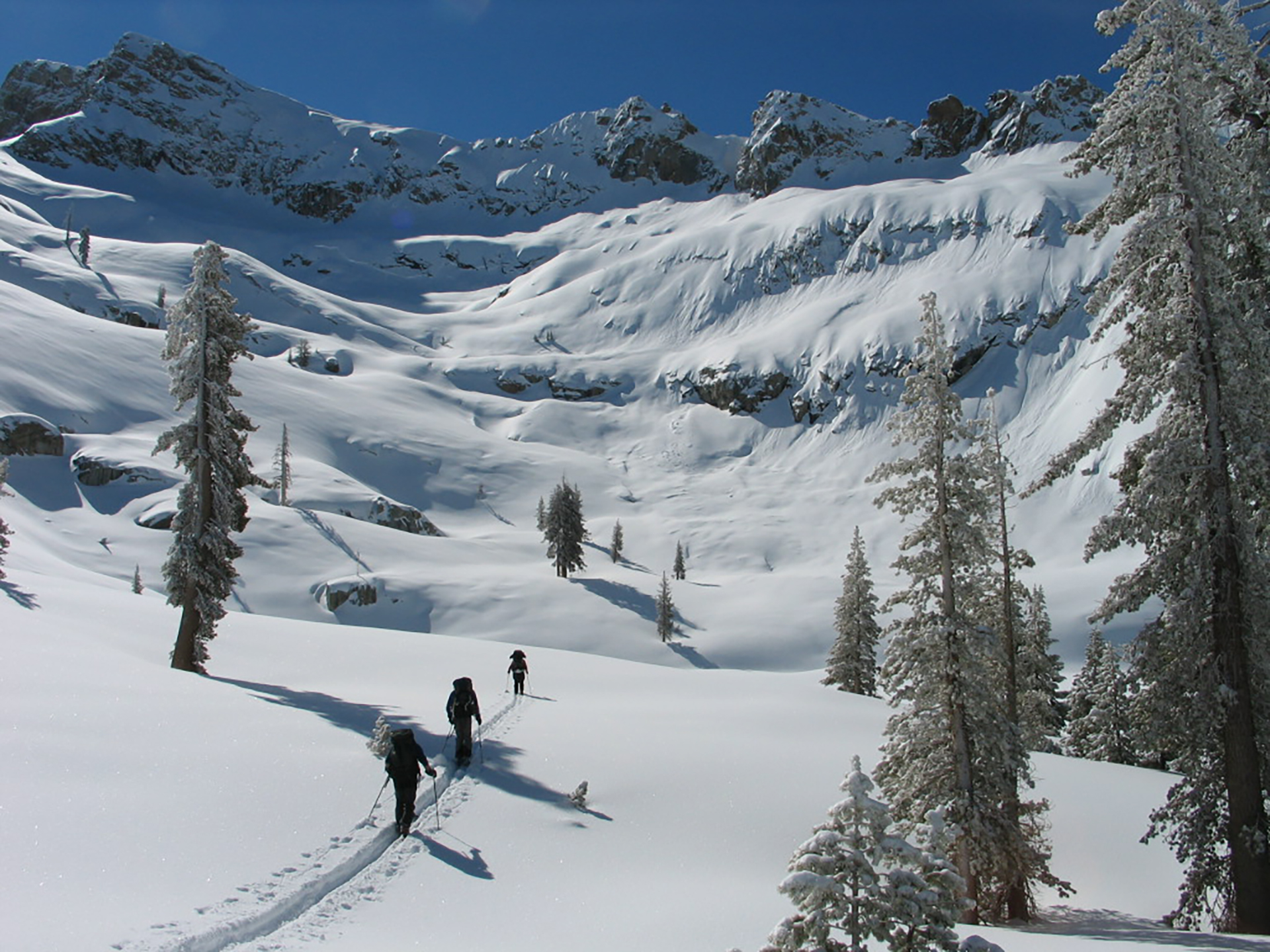
Atwell-Hockett Trail leads 10 miles one-way (20 miles round-trip) at a moderate slope through sequoia trees and up to Hockett Meadow. The first campsite along the trail is at 6 miles at Clover Creek. Other wilderness destinations include Evelyn Lake, Cahoon Rock, and the Golden Trout Wilderness, which is outside national park boundaries in Golden Trout Wilderness.
The text reads, This trail climbs through forest to Hockett Plateau. The large meadows and rolling hills of this gentle piece of high country contrast with peaks and crags of Mineral King destinations. Like most park trails, Atwell Hockett Trail leads into designated wilderness. One of the highest forms of protection for public lands, wilderness preserves untamed landscapes for you to experience. Possible destinations include: A photo of a grassy meadow. Near the edge, a rustic wood building stands by tall trees that ring the meadow. A line of upright wood posts mark a fence through the field. The caption reads, This is Hockett Meadow, 10.4 miles (or 16.7 kilometers) one way. Elevation: 8,499 feet (or 2,591meters). The trail breaks out of the trees and into this large meadow, where deer graze summer's rich grasses and wildflowers. A photo shows a fast-moving stream through a rocky clearing, surrounded by young sequoia trees. The caption reads, Golden Trout Wilderness in Sequoia National Forest. 18 miles (or 29 kilometers) one way. Elevation: 9,780 feet (or 2,981 meters) at park/forest boundary. South of the national park boundary lies Sequoia National Forest. Different regulations apply; check with a USFS ranger station for more information. A map of the Mineral King area shows our location at the Atwell Hockett Trailhead. The bottom photo is of a large flat meadow circled by conifers. A rustic log cabin with a peaked shingle roof stands in the meadow. Its chimney has a tall capped flue. It is the historic Hockett Meadow Ranger Station. A smaller wood shed is nearby. A quote from The Wilderness Act of 1964. Outstanding opportunities for solitude or a primitive or unconfined type of recreation.
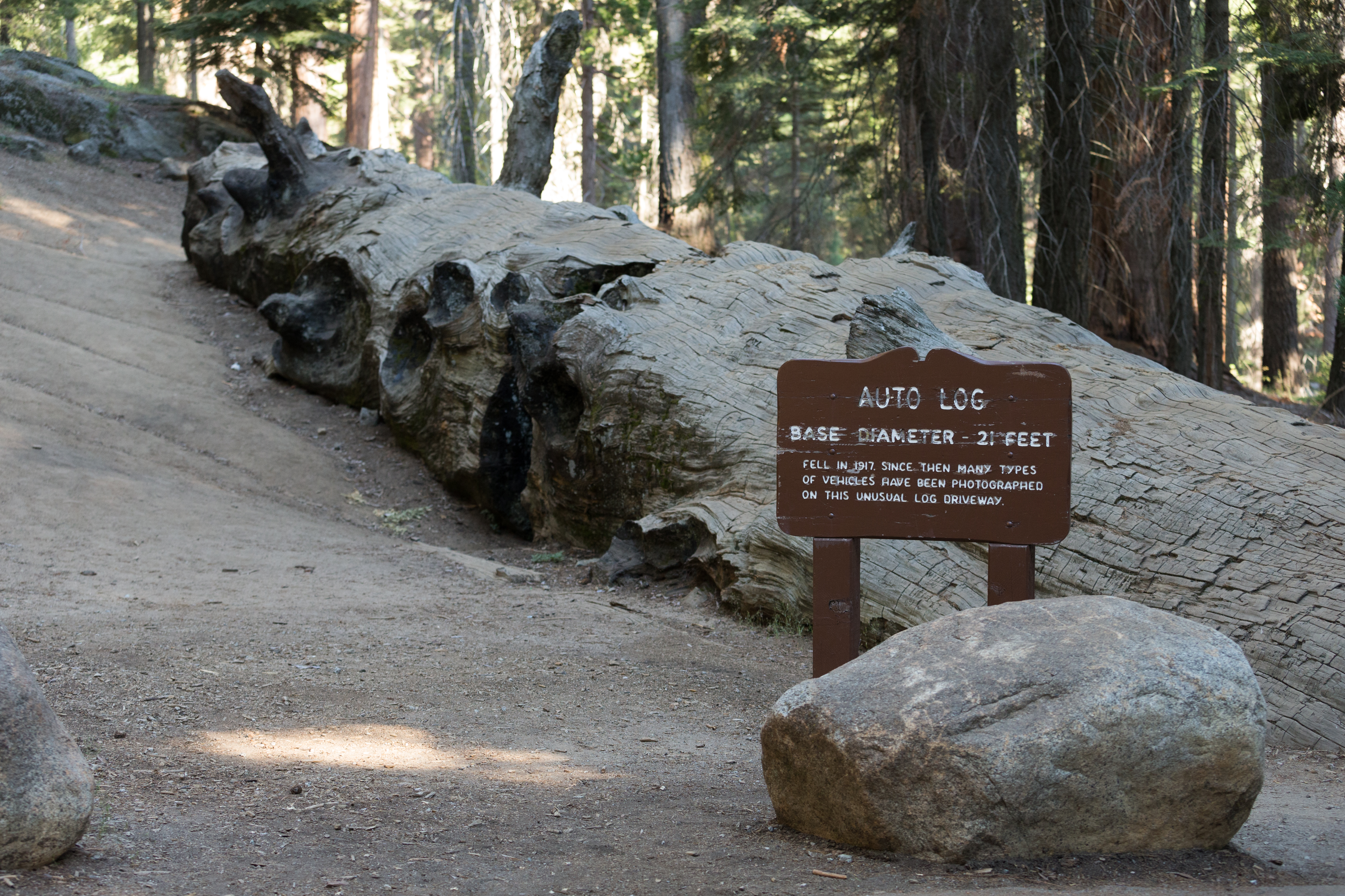
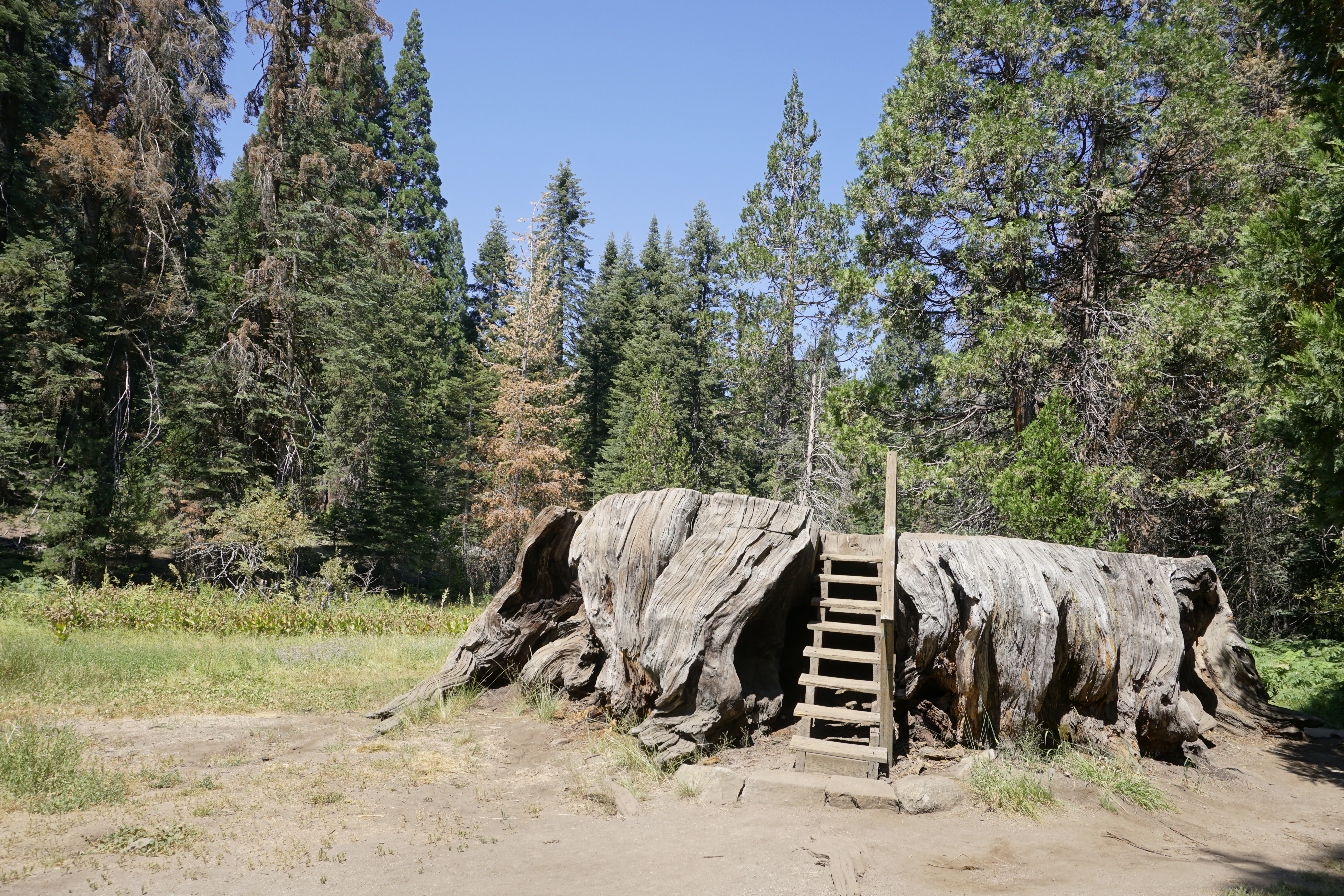
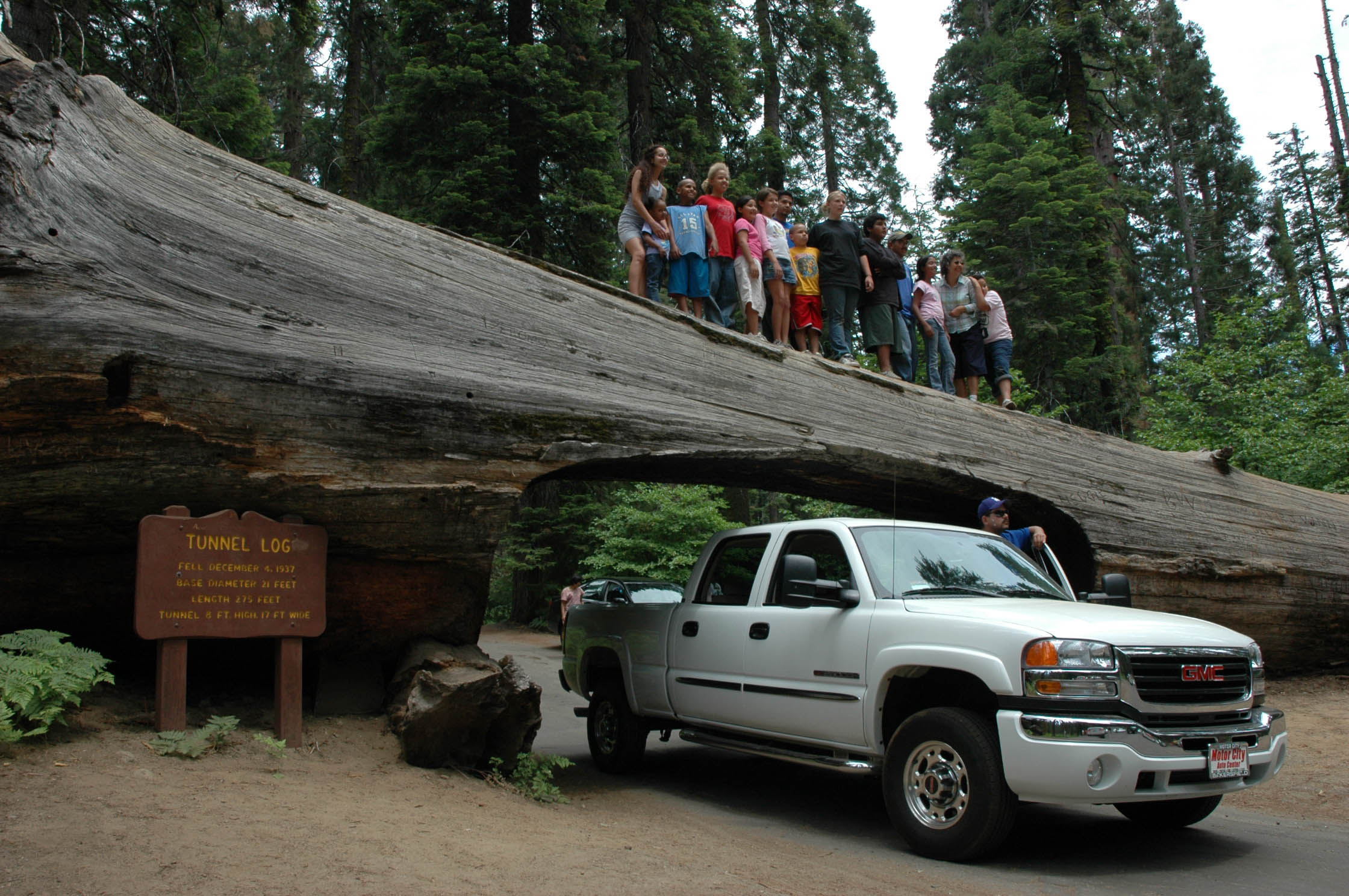
Once you could drive a car onto this fallen giant, but rot in the log put an end to the tradition. As you walk on it, consider these massive trees that dwarf modern vehicles and can support their weight. Be sure to read see the wayside exhibit here about the nearby Booker T. Washington and Col. Young trees, named for two giants in history.
You are on a forested slope next to a very large trunk of a fallen sequoia. On the uphill side of this enormous tree is a small parking lot. The road up to the lot drives past a tangled ball of roots at the end of the trunk. The front of the parking lot butts right up against a flattened area carved out along the top of the fallen tree. This is the spot where the cars used to be able to drive onto the log for photos. <br /><br />The border between the lot and the historic "photo op" is marked with upright log posts about two and a half feet high. To the left of these posts, when facing the tree trunk, is a wooden sign engraved with white lettering. It reads,<br /><br />Auto Log <br />Base Diameter - 21 feet. <br />Fell in 1917. Since then many types of vehicles have been photographed on this unusual log driveway. <br /><br />There is a short-cut to get below the tree, to a spot where many people like to take pictures. If you walk another 20 feet past the wooden sign, there is a narrow dirt path through a cut in the trunk. This opening in the log is about 2 feet wide and 12 feet high. From below the log, photos can be taken, looking up at the log with people standing on top.
A short walk from the Giant Forest Museum, Beetle Rock offers a view of the western edge of the park and the San Joaquin Valley below. While this view can be beautiful at sunset, you are also likely to witness the smog that people are surprised to find here. A wayside exhibit (to the right as you approach the rock) explains the source of pollution.
Two broad, low rounded domes of grey rock. Combined, they are bigger than a football field. The rock's texture feels grainy with and is marked with fissures and crevasses. Holes like potholes of various depths are scattered across the surface. Here and there a thin top layer of rock appears to be missing, creating a thin edge along the surface of the dome, like the dried outer layer of a giant onion. Beyond the edge of the rock is a view of forested hills. Layer after layer of hills descend into the distance, becoming fainter and fainter, until they are hard to see against the hazy sky. The conifer trees that grow in the rock's cracks are only about 5 to 10 feet high, and have many brown needles.
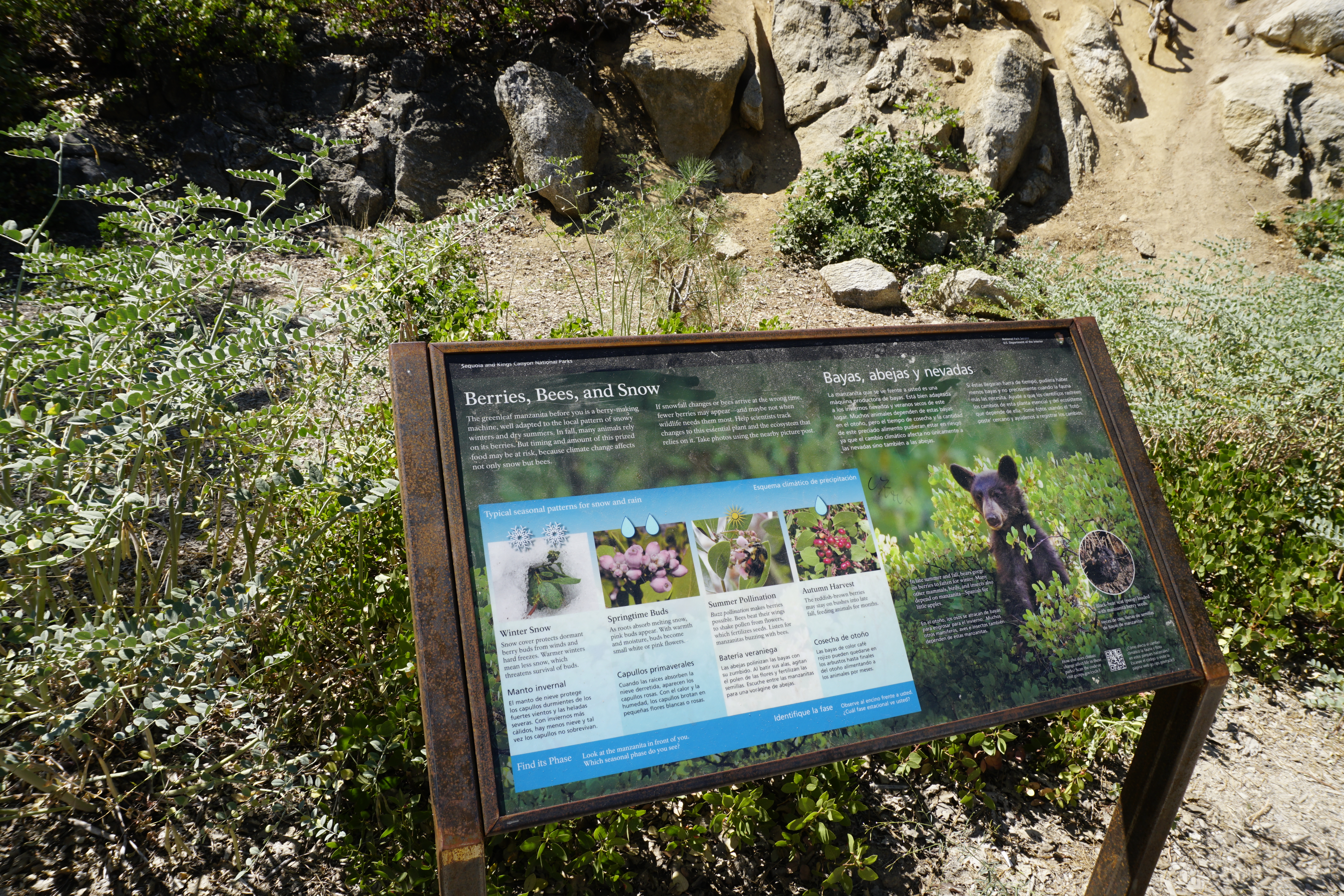
This wayside at the far end of the Big Stump Picnic Area gives insight into an important food plant here, the manzanita. How might climate change affect the bees and snow this shrub relies on? How might climate change affect the manzanita berries that other animals rely on?
Text is shown in English and Spanish, but for this audio description we will only read English. This wayside exhibit, titled "Berries, Bees, and Snow", shows how wildlife depends on manzanita plant flowers and berries. The View: Behind this wayside exhibit, within easy reach from the sidewalk, is a Manzanita bush, 2 to 3 feet high. Depending on the season of your visit you can touch its leaves and feel for berries. But use care, as there are often bees around this bush. The area around you has covered picnic benches and paved paths. The text on the panel reads, The greenleaf manzanita before you is a berry making machine, well adapted to the local pattern of snowy winters and dry summers. In fall, many animals rely on its berries. But timing and amount of this prize food may be at risk, because climate change affects not only snow but bees. If snowfall changes or bees arrive at the wrong time, fewer berries may appear and maybe not when wildlife needs them most. Help scientist track changes to this essential plant and the ecosystem that relies on it. Take photos using the nearby picture post. A photo of a black bear, standing amid bushes with bright green oval leaves. The bear is covered with black fur, with a tan muzzle, black nose, and large round ears. The caption reads, In late summer and fall, bears gorge on berries to fatten for winter. Many other mammals, birds, and insects also depend on manzanita, Spanish for little apples. A photo shows a black textured clump with tan colored nuts mixed in it, on the ground. The caption reads, Black bear scat (or poop) loaded with manzanita berry seeds. Four photos of a manzanita branch with oval pointed leaves show how it looks during each season. Simple graphic icons illustrate weather conditions. From left to right, Winter Snow (with two snowflake icons): leaves with tiny green clusters are partly covered by snow. The caption reads, Snow cover protects dormant berry buds from winds and hard freezes. Warmer winter mean less snow, which threatens survival of buds. Springtime Buds (with two raindrop icons): A cluster of pink bulb shaped flowers. The caption reads, As roots absorb melting snow, pink buds appear. With warmth and moisture, buds become small white or pink flowers. Summer Pollination (with a sun icon): A bee is inside the flower cluster. The caption reads, Buzz pollination makes berries possible. Bees beat their wings to shake pollen from flowers, which fertilizes seeds. Listen for manzanitas buzzing with bees. Autumn Harvest (with a single raindrop icon): A cluster of bright red berries. The caption reads, The reddish-brown berries may stay on bushes into the late fall, feeding animals for months.
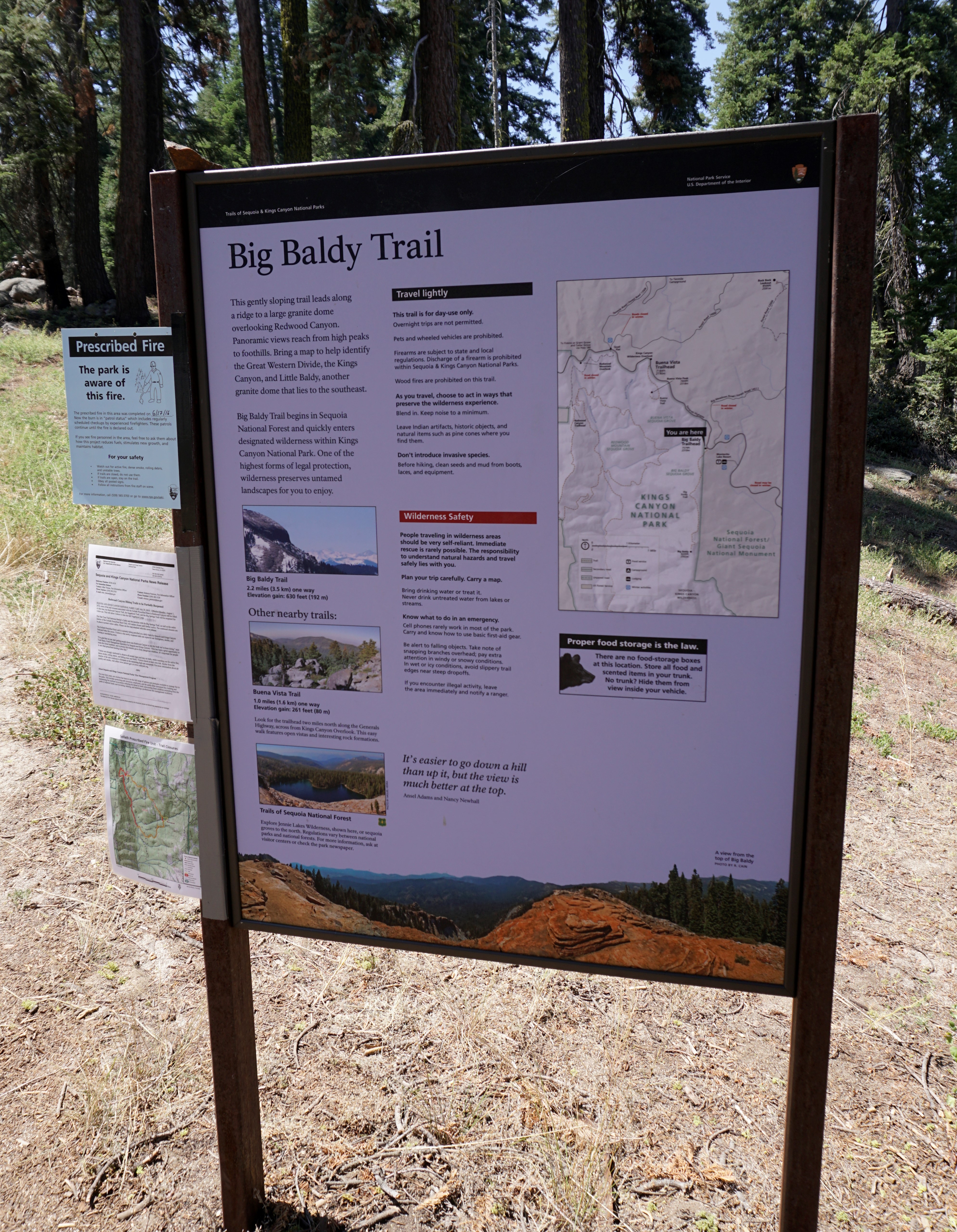
This trailhead orientation panel shows a map and images of the Big Baldy Trail area.<br /><br />The Big Baldy Trail leads 2.2 miles one-way (4.4 miles round-trip) at a gentle slope along a ridge toward panoramic views of Kings Canyon and the Great Western Divide. This trail is for day-use only; overnight camping is not allowed.
This is the audio description of the exhibit panel at this trailhead. This gently sloping trail leads along a ridge to a large granite dome overlooking Redwood Canyon. Panoramic views reach from high peaks to foothills. Bring a map to help identify the Great Western Divide, the Kings Canyon, and Little Baldy, another granite dome that lies to the southeast. Big Baldy Trail begins in Sequoia National Forest and quickly enters designated wilderness within Kings Canyon National Park. One of the highest forms of legal protection, wilderness preserves untamed landscapes for you to enjoy. A photo of a rounded mountain peak with snow and scattered conifer trees. Snowcapped mountains are seen in the distance. The caption reads, Big Baldy Trail. 2.2 miles (or 3.5 km) one way. Elevation gain: 630 feet (or 192 m). Other nearby trails: A photo of a tree lined ridge with piles of large boulders. Forest covered mountains are seen in the distance. The caption reads, Buena Vista Trail. 1.0 miles (or 1.6 km) one way. Elevation gain: 261 feet (or 80 m). Look for the trailhead two miles north along the Generals Highway, across from Kings Canyon Overlook. This easy walk features open vistas and interesting rock formations. A photo from a rock covered ridge looking down at a deep blue lake nestled in a forest. The caption reads, Trails of Sequoia National Forest Explore Jennie Lakes Wilderness, shown here, or sequoia groves to the north. Regulations vary between national parks and national forests. For more information, ask at visitor centers or check the park newspaper. A map shows the location of the Big Baldy Trailhead. The bottom photo of a ridge made up of layers of rust colored rocks, stacked like pancakes. A densely forested mountain range and valley is seen in the distance. The caption reads, A view from the top of Big Baldy A quote by Ansel Adams and Nancy Newhall, "It's easier to go down a hill than up it, but the view is much better at the top."
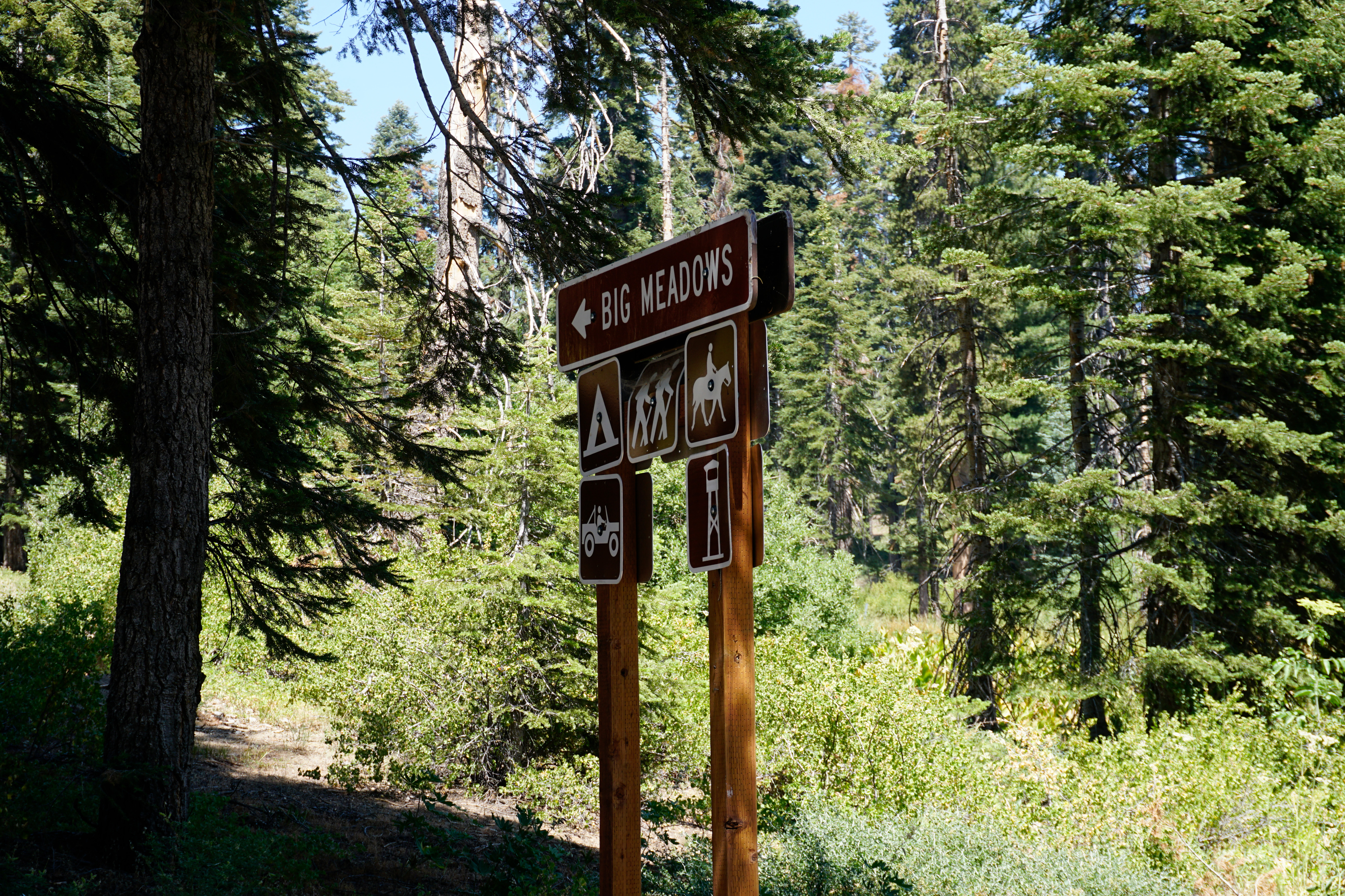
On Forest Service land between the park areas of Grant Grove and Lodgepole, this road accesses primitive campgrounds, the Big Meadows Pack Station, and Buck Rock Fire Lookout.<br /><br />This road can close, especially in the winter when conditions are snowy or muddy.
This entrance station is probably your first stop within the parks if you are coming from Fresno. On Highway 180, this is where you pay the entrance fee to Sequoia and Kings Canyon National Parks and the Hume Lake District of Sequoia National Forest.
Surrounding the Big Stump Entrance Station is a forest of conifer trees, including sequoias. Large granite rocks line the highway. Here, at the entrance station, the road widens from a two-lane road into a three-lane road, with two heading up into the park. On the park exit side of the road, is a small pull out with a wooden building with a peaked green roof and two sets of brown metal double doors. In the median separating the exit side of the road from the entrance, is a one-story structure, as well as a red stop sign and stop light. This rustic structure has a stone base, about 3 feet high. The upper part is made of planked pine, with wood framed windows, a plank eave, and very thick wooden beams, supported by thick curved wooden braces. These stick out on the entrance side, shading that part of the building. It has a cross gabled roof with green shingles. The words "Kings Canyon", in capital letters, are carved into a thin granite slab near the top of the building. Windows adjacent to the entrance and exit lanes are open so that park staff can assist drivers. A pole behind the building is flying the United States flag. Signs provide information about fees, vacancies, and safety. Separating the two entrance lanes is a second structure that is much smaller, about the size of a toll booth. It is a smaller version of the building just described. Just past the entrance station is a sign with current information on campground status and occupancy.
The first rest area after the park entrance station on Highway 180, makes this a perfect spot to get your bearings after the drive up from the San Joaquin Valley. It includes the trailhead for the Big Stump Trail, which leads to the Mark Twain Stump via a 1.5-mile (2.4 km) hike. A small staircase on the stump lets you climb onto it.
Adjacent to the parking area are recycling and trash containers and bulletin boards. A wooden building, with wood beam supports, has restrooms for men, on the left, and women, on the right. In between, along the wall, is a map and a water fountain. Next to the building, is a large cut tree stump, about nine feet high. You can touch the bark and walk around it. A paved path leads to a paved pad with picnic tables. The tables are sheltered by galvanized metal roofs, mounted on a wooden post and beam structure rising from stone bases. Between the picnic tables, you can venture beyond the sidewalk, but there are many uneven areas. This space has rock mounds with low shrubs and trees. At the far end of the parking area is a small hilly section with dirt, rocks, large fallen branches, low shrubs and conifer trees.
Known as the Mark Twain Tree, this Giant Sequoia reached 16 feet (4.8 meters) in diameter. Even after the national park was established, travel to the sequoia groves was difficult, and many people simply didn't believe trees could grow so large. In 1891, the Army cut down this sequoia so it could be displayed to astonished crowds in New York and London.
This wayside exhibit, titled "The Ultimate Sacrifice", shows black and white photos and text about the Mark Twain Stump. The View: Continue along this short dirt path through a conifer forest, several hundred feet to a giant sequoia tree stump. The stump stands about 5 feet tall. The top has been cut away and you can climb up a few wooden stairs to the top. The top surface is uneven and there are no safety rails. Once on top, one can see how the trunk's deep layers of tree growth radiate out in concentric layers, like a cut onion. You can also walk around the base of the stump, to discover how truly huge this tree was. On the wayside is a photo of this forest, in 1891. A few large sequoias are surrounded by sparse younger trees. A giant sequoia tilts dramatically. The cut on the right side of its base is wedge shaped. The caption explains that a photographer shot this sequoia mid-fall, and that the forest around you has regenerated since then. The text reads, The Mark Twain Stump in front of you has a unique story to tell. In 1891, while lumbermen were cutting other sequoia trees for grapevine stakes, lumber, and shake shingles, the Mark Twain Tree was selected for another fate, world fame. The American Museum of Natural History in New York City wanted a cross section of a giant sequoia for display. The Mark Twain Tree was chosen to provide the slab. Through this huge tree's sacrifice, many people far from California could marvel at the immensity of sequoias. Some vowed to preserve the remaining giants as living, growing monuments. At the top left is a historic photo of a woman, in a long dark dress, posing in a line with four children and a man with a beard, in front of a giant sequoia that is twice as wide as their group. This is the Ben Hicks family at the still standing Mark Twain Tree in the 1880s. The tree was nearly 300 feet (or 91.4 meters) tall and was 91 feet (or 27.7 meters) around at the base. A photo of the trunk of the tree, with a deep gouge on the right side, and a large pile of wood chips. Two lumberjacks chop and saw inside the cut. It took 13 days to bring the tree down. A photo of the stump, with a cut slab next to it. Lumberjacks cut the slab into movable pieces for rail shipment to New York. Another slab went by ship to the British Museum in London. A photo of three girls looking at a slab mounted on a display in a New York museum.
Big Trees Trail circles Round Meadow in a 0.7 mile loop. It is flat, paved, and has benches along the way. Informational displays offer insight into what you are experiencing. Watch for yellow-bellied marmots, bears, and other wildlife. After taking this trail, consider walking the Hazelwood Meadow Trail on the other side of the road; it leads through another part of the grove.
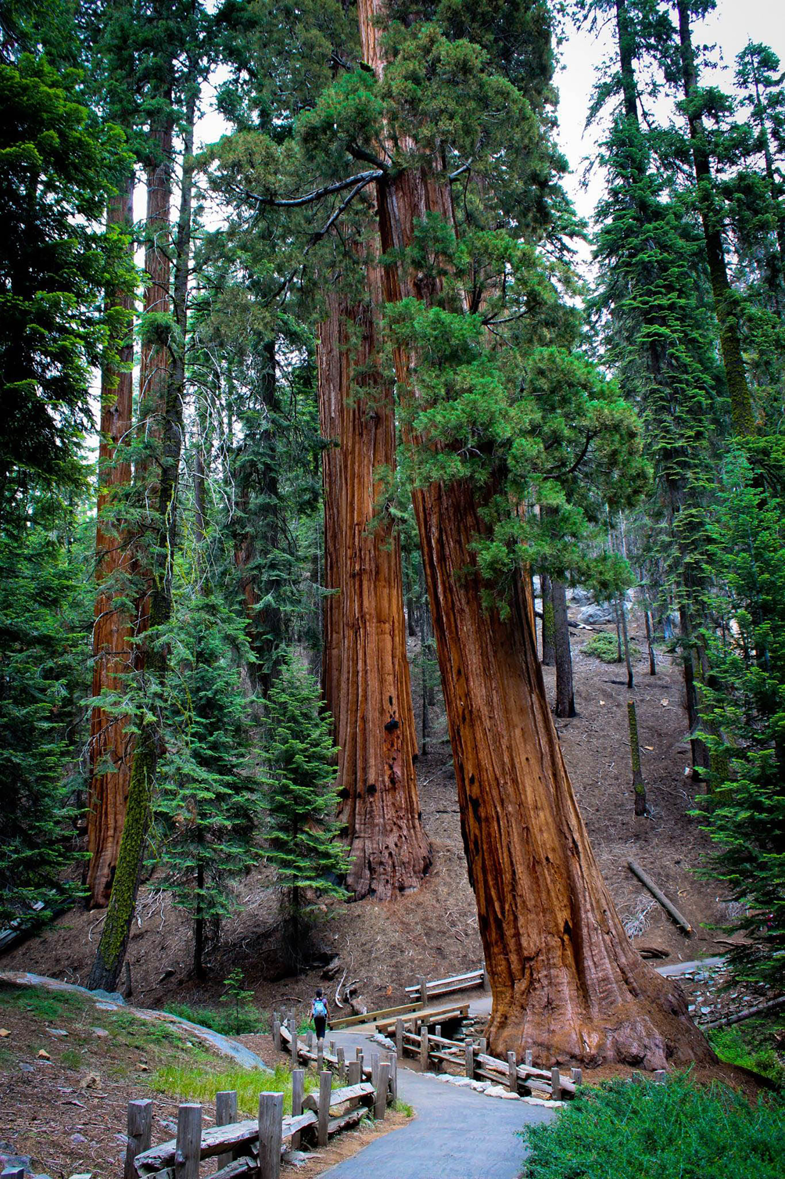
The Big Trees Trail circles a meadow within a forest that's canopied with pine, incense-cedar, fir, and, of course, sequoia trees. The branches of young sequoias give them the cone shape of most other conifer trees, like a Christmas tree. Mature sequoias, however, have trunks that become much bigger than the branches. Branches only start about halfway up the trunk. Mature sequoias, called monarchs, are nature's skyscrapers. Trying to glimpse their tippy tops could give you a sore neck. Their trunks are reddish brown, with thick layers of deeply furrowed bark that is soft and fibrous on the surface, like shredded wheat cereal. Some trunks have dark, indented triangular scars, caused by fire. The forest floor is covered with a thick, soft carpet of pine needles. Around large sequoias, the ground is also covered with thin strips of bark that have shredded away from the tree trunks. The forest creates a rich habitat for a large variety of wildlife, including black bears, mule deer, chickarees, and gray squirrels. Depending upon the season, you may also hear the sounds of forest birds: ravens, nuthatches, and Steller's jays. As the seasons change, so does the look of the forest. Spring brings warming temperatures and small colorful wildflowers in the meadow. Winter brings a blanket of snow.
A giant sequoia dedicated to the memory of Booker T. Washington-a leader in the African-American community during the late 18th and early 19th centuries-stands before you.Colonel Charles Young-a commissioned officer in the US Army who served as the first superintendent of Sequoia National Park, dedicated this tree in honor of a man he deeply admired.
A wooden sign on wood posts with white embossed lettering reads, Booker T Washington Tree The dirt path to the Booker T. Washington tree heads slightly downhill from the road. The tree is about 100 yards away. There is a large fallen branch between the road and the tree. A canopy of Ponderosa Pines and Douglas firs provide a blanket of scented shade.
This 2.5-mile trail in the national forest outside the park leads to the magnificent Boole Tree, one of the few monarch sequoias spared by 19th-century logging. It also offers great views over and across the Kings River country. Take Highway 180 2.5 miles north of Grant Grove, and turn onto the dirt road. In about 2 miles, you pass through aptly named Stump Meadow, the remnants left by an 1800s logging operation.
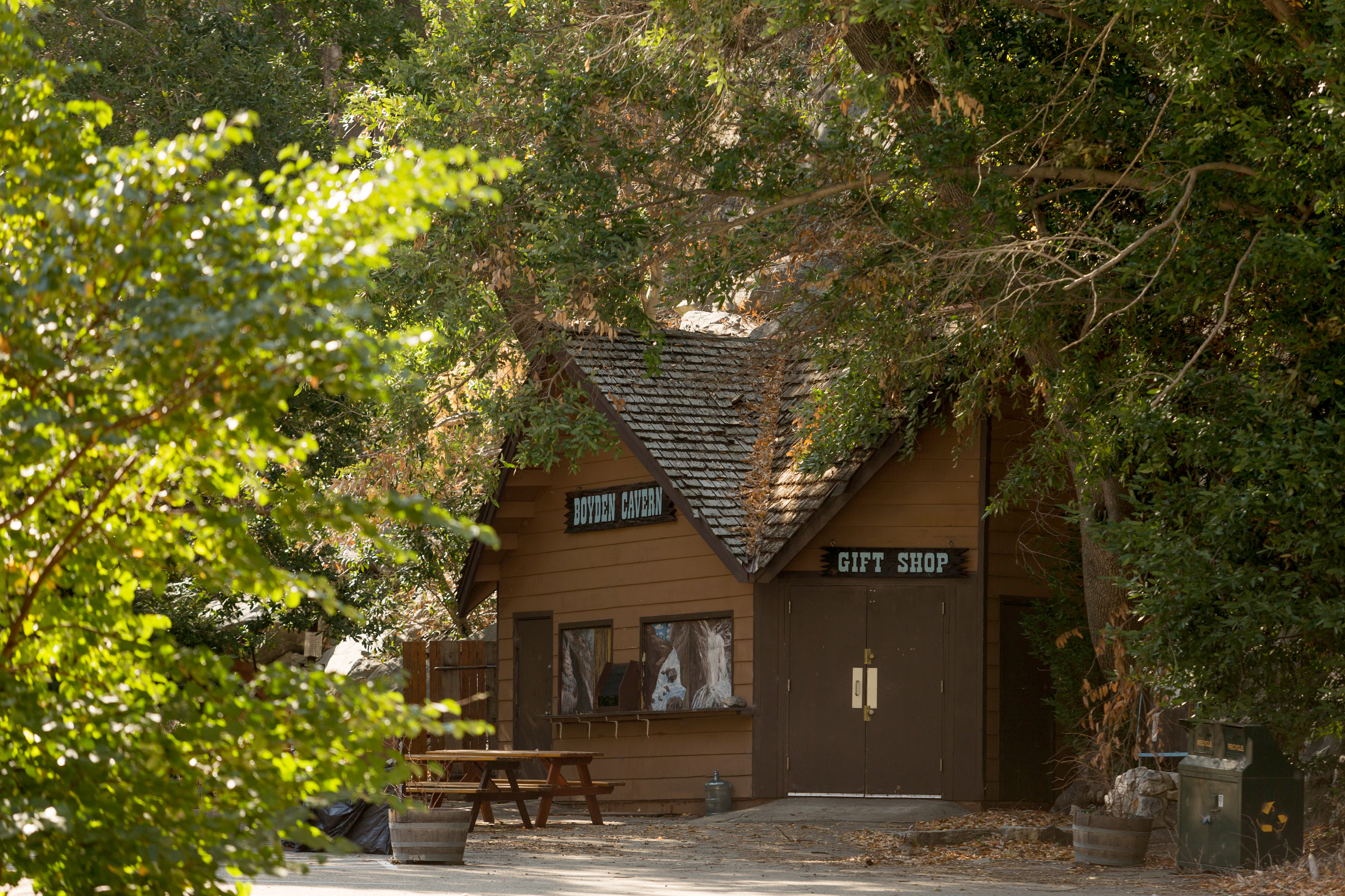
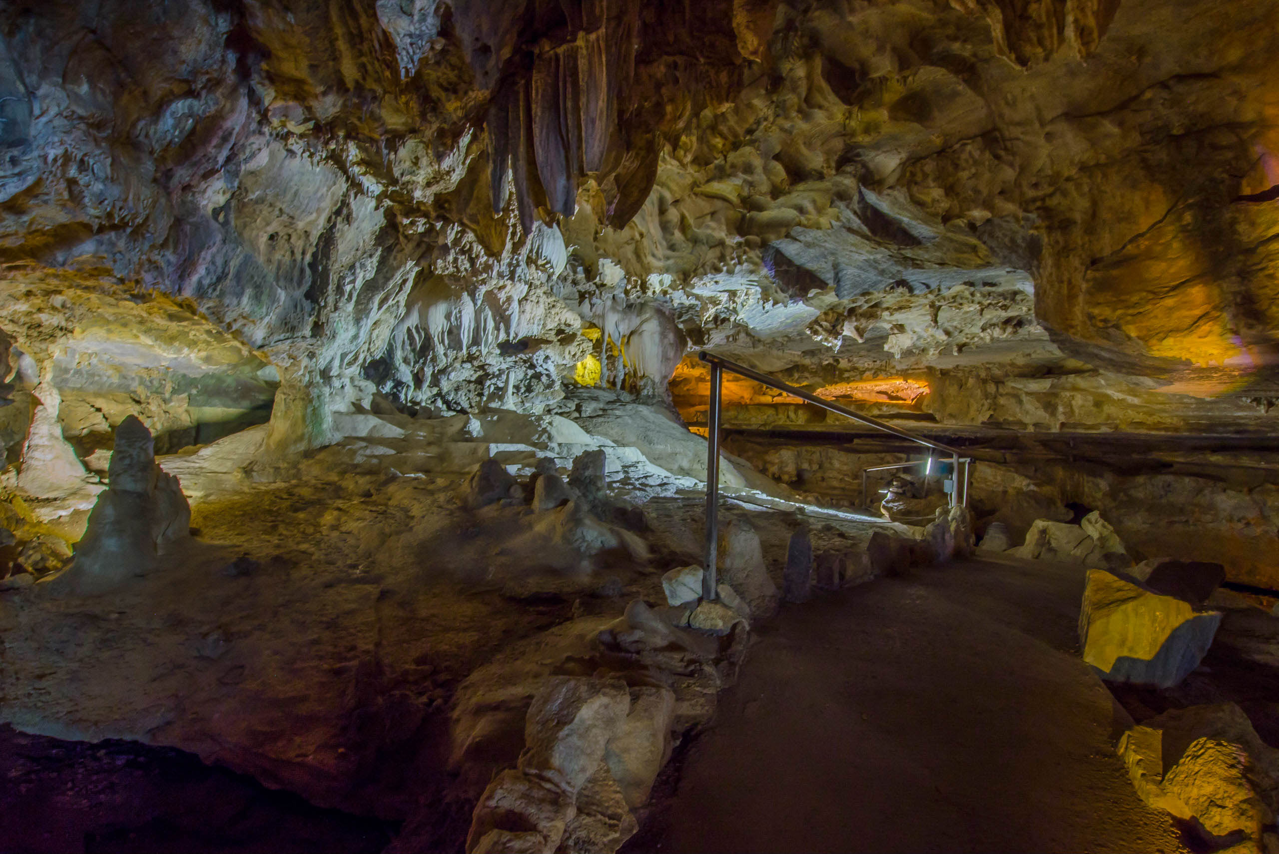
Take a guided, 50-minute walking tour through this cavern, located below the towering 2,000 foot marble walls of the Kings Gates. A short but very steep trail leads to the cave, traveling under and around rock formations. Tours are appropriate for all ages and are offered by a U.S. Forest Service partner, daily from 10 a.m. to 5 p.m. Tour operators recommend you wear hiking boots and a light jacket.
We are in a V-shaped river cut valley, near the entrance to Boyden Cavern. This section of the river and the highway are surrounded by tall marble cliffs. Yucca plants stick up from these cliffs. They have a spiky ball of leaves at their base, with a single tall spire of flowers, rising like a plume above it. Along the base of the cliff are bay laurels, with long thin dark green leaves. If you run your hands over the leaves, you can smell the fresh scent. There is a brown wooden building with peaked roofs and long wood planks on the outer walls. It has a double door on the end closest to the parking area with a wooden sign with white lettering over it that reads, "Gift Shop". The wall that faces the river has a door at the far left side, and two windows on the right, with a ledge the runs below them. A small wooden pamphlet holder is attached to the ledge between the windows. Over the windows, a wooden sign with white lettering reads, "Boyden Cavern". This is the concession building that sells tickets to the cavern. Beside it is a trail up to the cavern entrance, which is alongside the river. The trail up to the cave is not accessible.
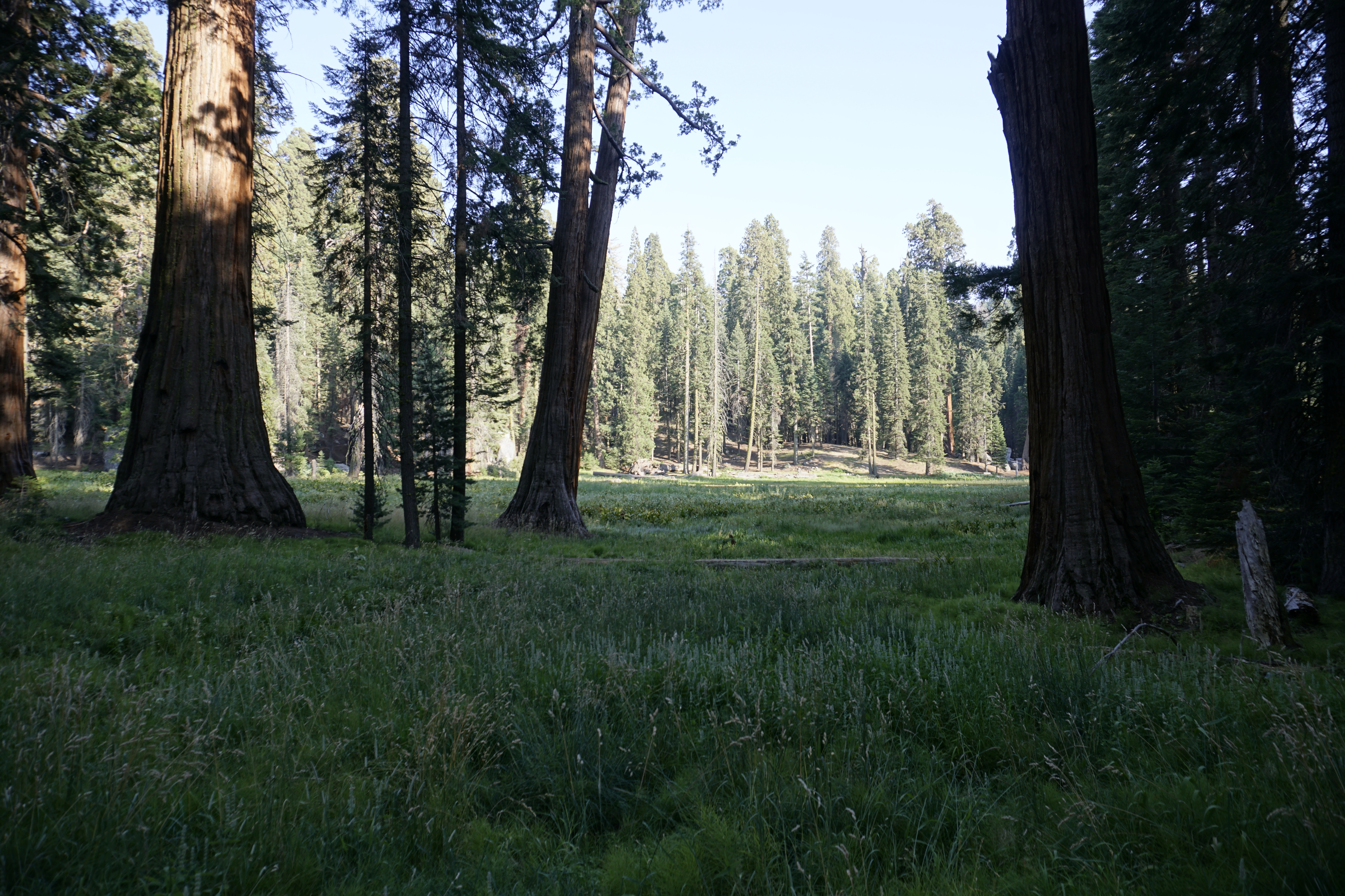
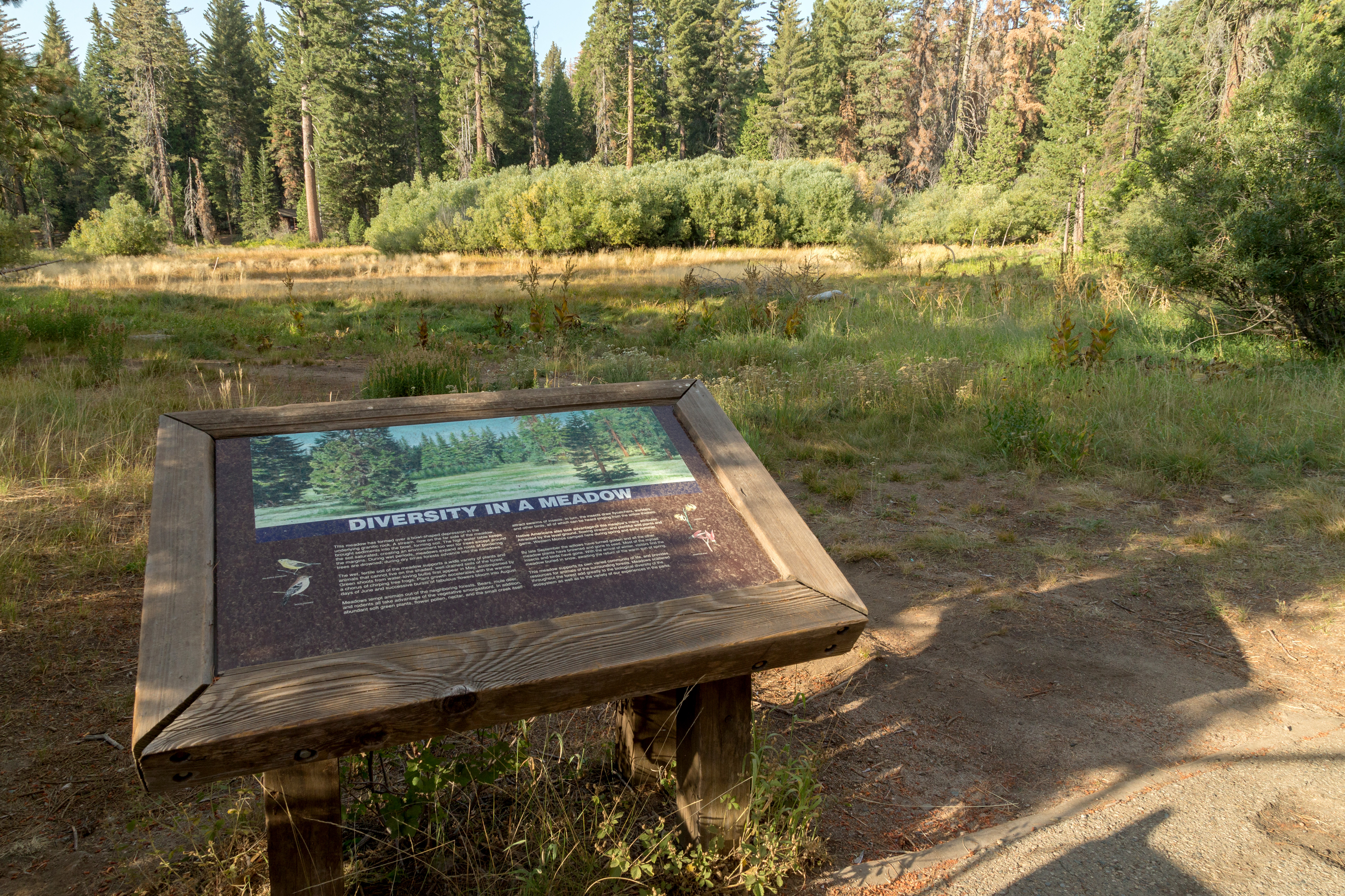
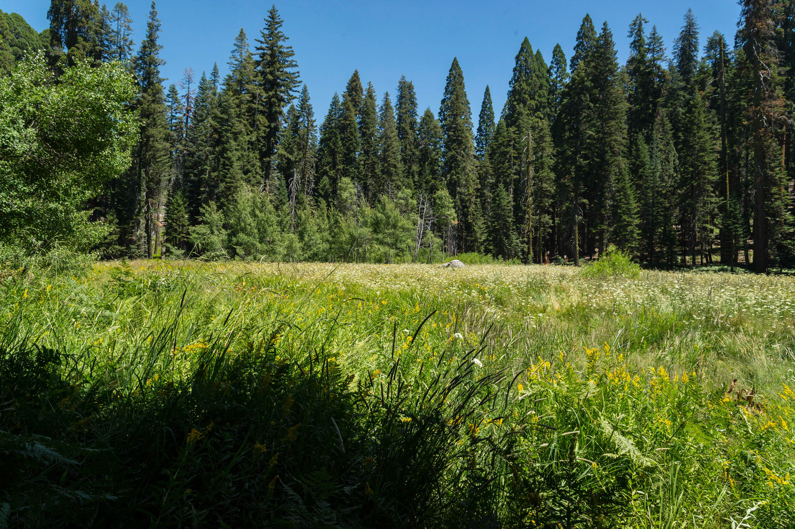
This soft, moist, open pocket of soil contrasts with the surrounding forest and granite bedrock near the ground's surface. Enjoy the sounds of birds and insects that rely on the meadow for food, lodging, and hiding places. Relatively uncommon here, meadows provide critical habitat to many species.
In front of you is a wide meadow surrounded by trees and shrubs. Most of the meadow's area is covered by grasses and low herbaceous plants that vary by the season. In spring, new grasses begin to grow as the snowpack melts. In summer, the grasses grow taller and greener, with wildflowers intermixed. In fall, the grasses turn brown. And in winter, snow covers the meadow. In addition to the grasses are sections with low, shrubby trees. Listen for the sounds of the birds that frequent this meadow.
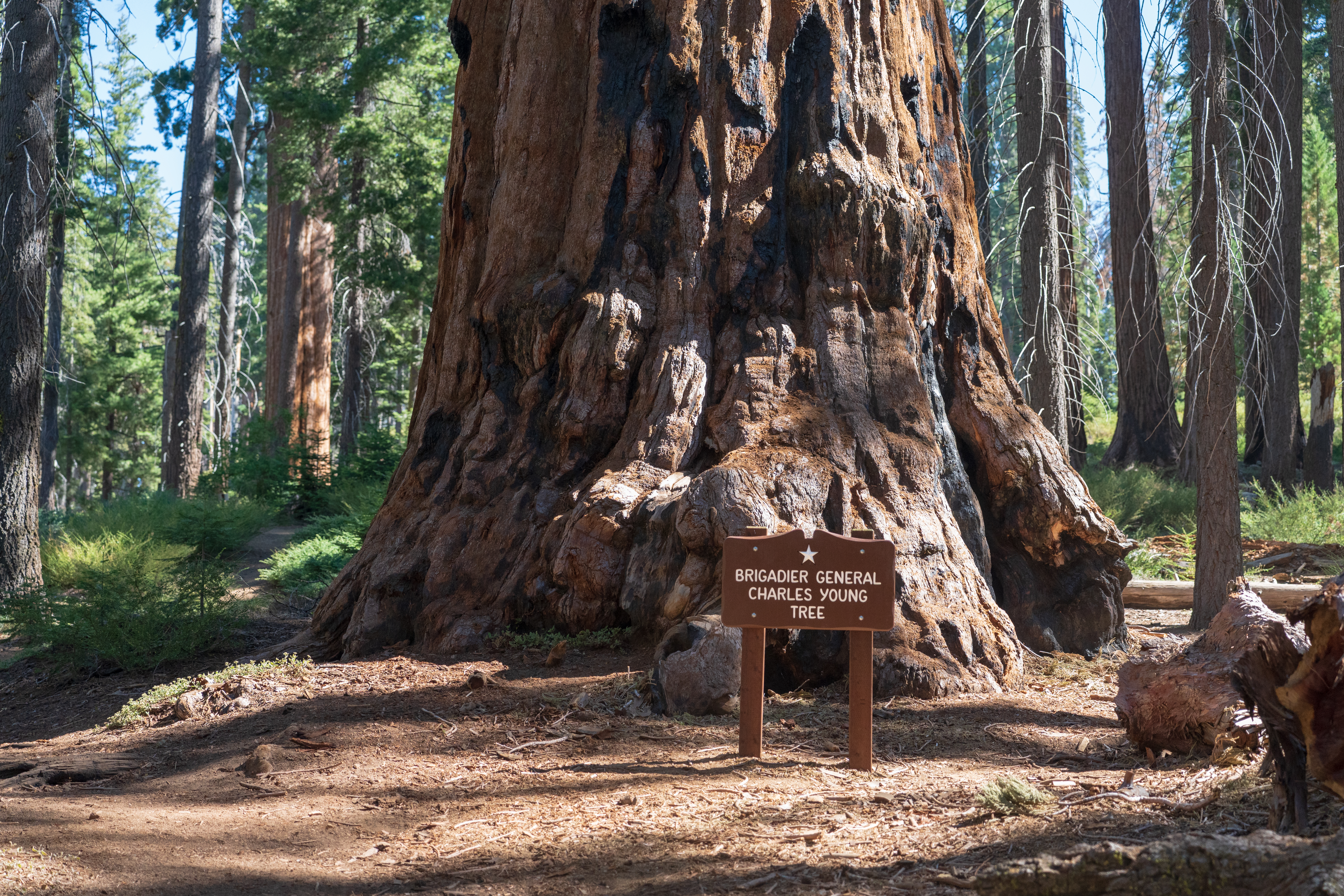
In the fall of 1903, the Buffalo Soldiers who oversaw these parks that year held an end-of-season picnic. A local resident who attended, Phil Winser, wrote the following about Captain Charles Young, the leader of this contingent and the first African American superintendent of any national park: "They wanted to name a tree for our captain but he refused, saying they could do so if they felt the same way, twenty years hence..." He chose instead to name a sequoia for educator B
A wooden sign on wood posts with white embossed lettering reads, "Colonel Young Tree." The footpath has a slight uphill grade. The Colonel Young Tree is about 200 yards away at the top of the dirt path. You can probably smell the scented pines around you. A canopy of Ponderosa Pines and white firs provide a blanket of shade. Along the sides of the path, depending on the season, there are clusters of purple-blue flowers. As you make your way to the end of the path, you take a sharp turn to the right, and then you see it: a majestic monarch sequoia. If you walk around it, you can feel smoother, darkened indents in the tree about 5 to 8 feet across. They are called fire scars. If you touch that darkened part, your hands may become dark with charcoal.
From here hike up to Buena Vista Peak and its 360-degree view of park, forest, and California's huge Central Valley. It's a two-mile round-trip hike, making it one of the most easily accessible peaks in the park. This uphill walk is fairly gentle.
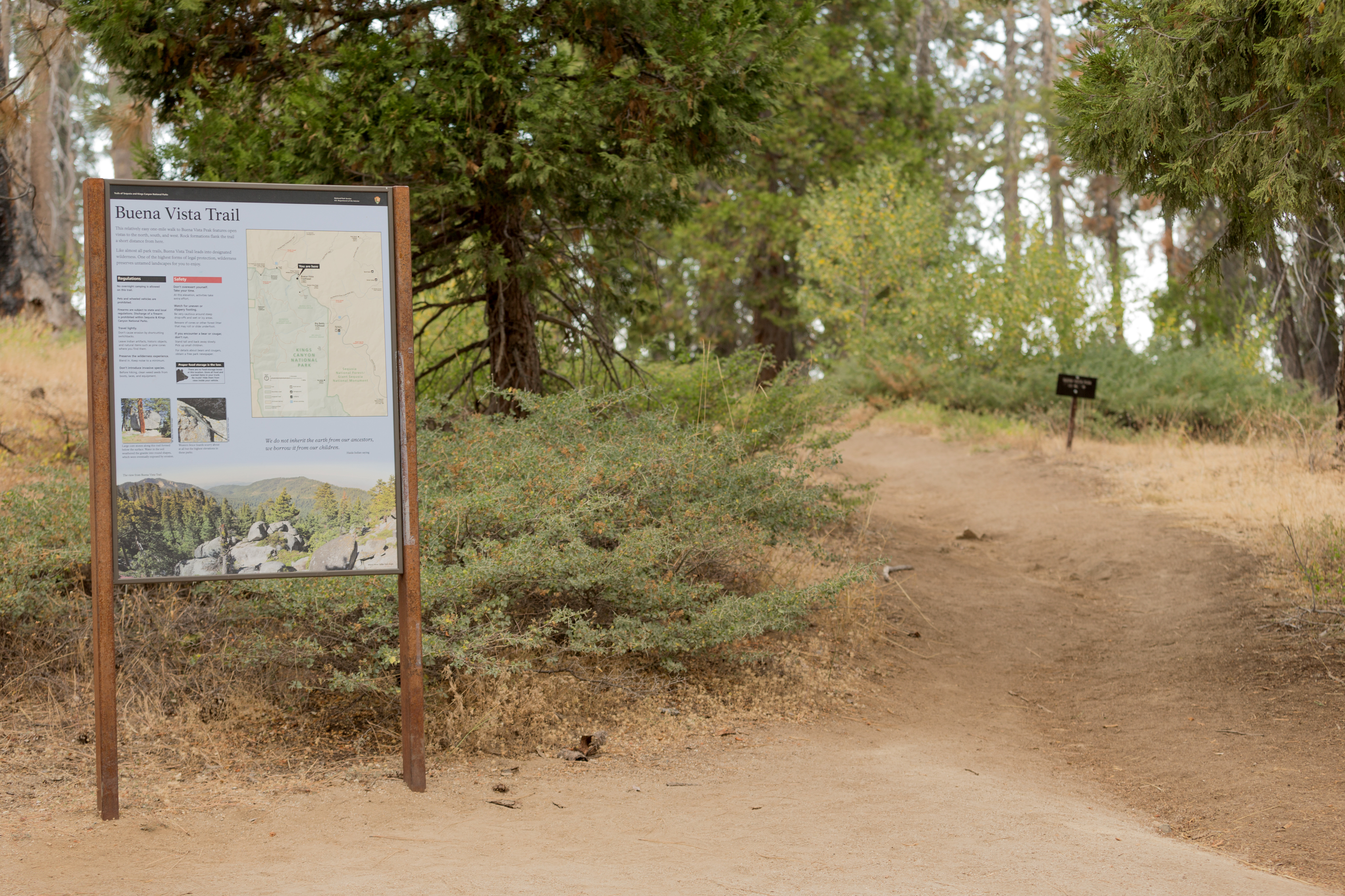
This trailhead orientation panel provides a map and photos of Buena Vista Trail. The text reads, This relatively easy one-mile walk to Buena Vista Peak features open vistas to the north, south, and west. Rock formations flank the trail a short distance from here. Like almost all park trails, Buena Vista trail leads into designated wilderness. One of the highest forms of legal protection, wilderness preserves untamed landscapes for you to enjoy. The map of Sequoia and Kings Canyon National Parks shows the Buena Vista trailhead location. A photo shows an incense cedar tree in front of a large boulder that has a deep fissure running through it horizontally. The boulder, formed underground, was shaped by water below the soil's surface, and later was exposed by erosion. The caption reads, Large core stones along this trail formed below the surface. Water in the soil weathered the granite into round shapes, eventually exposed by erosion. Another photo shows a Western fence lizard scurrying up a stone. The caption reads, Western fence lizards scurry about at all but the highest elevations in these parks, A photo at the bottom shows a view from Buena Vista Trail, with large granite boulders and tree-lined ridges. The caption reads, The view from Buena Vista Trail A Haida Indian saying: "We do not inherit the earth from our ancestors, we borrow it from our children. "
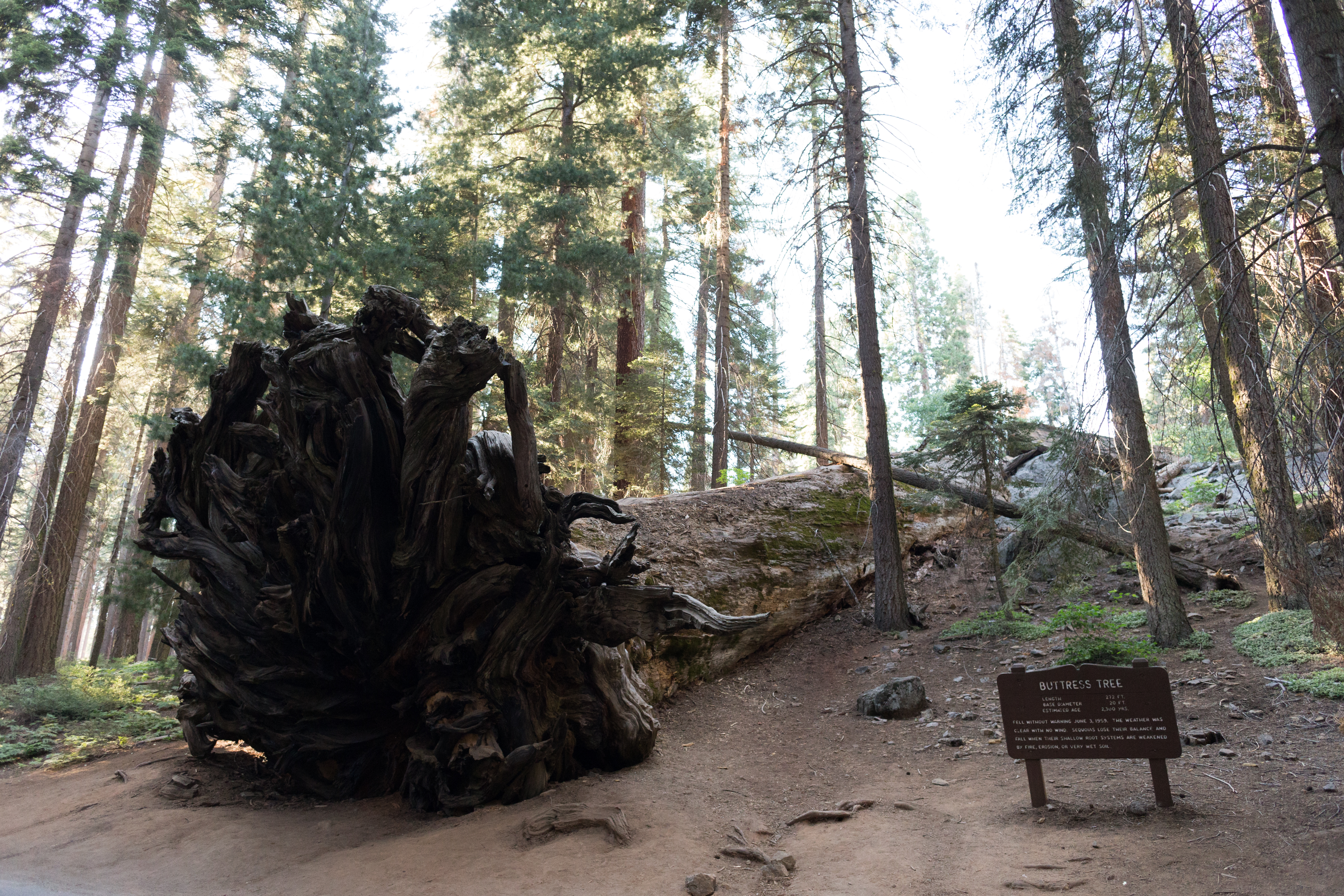
The Buttress Tree fell without warning on June 3, 1959. Its roots, like all sequoias, grew in a shallow, matted maze. Although sequoia roots can extend as much as 300 feet outwards, they rarely grow deeper than 12 feet. This leaves the trees vulnerable to erosion and changing soil conditions.
Here, a sequoia has fallen over, and the root ball, over 20 feet in diameter, is upright on the side of the road. The trunk of the tree stretches away into the forest. You can touch the roots of the sequoia tree. The roots are intertwined like a honeycomb, branching out, as if each root piece was still digging into the ground. Dirt and rocks are still intertwined held tightly in the root system. Dirt and rocks are still held tightly in the root system. If you feel the between sections of roots, you may be able to find pieces of dirt and rock. Feel the very center of the roots, about 4 feet above the ground. There, the wood is softer and shredding into little pieces.
This wayside exhibit, titled, "Call the Cavalry," shows photos and text about the U. S. Cavalry and The Parker Group.
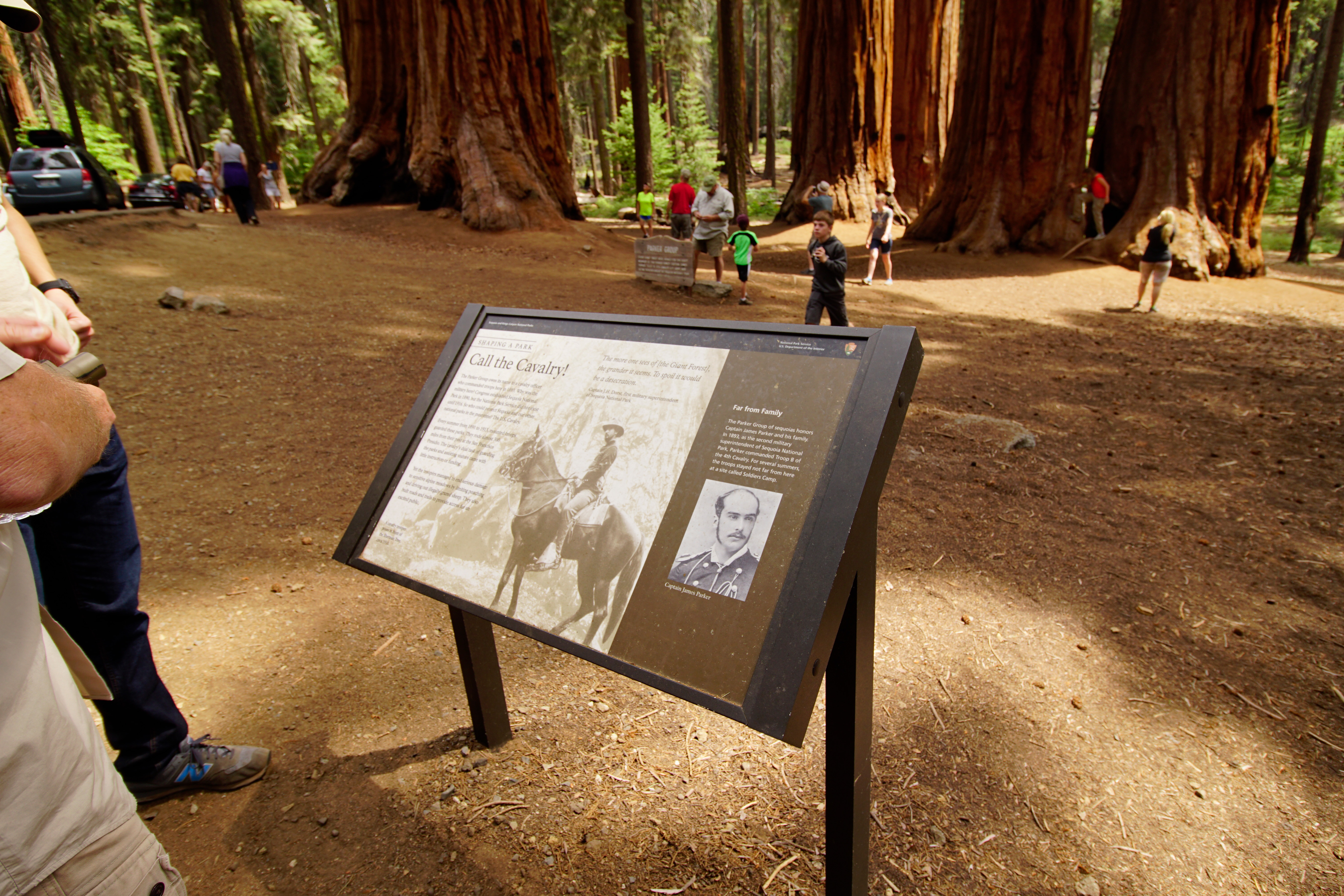
The View: You are standing in the forest; a cluster, of giant sequoia trees, is 100 feet ahead. The ground around the trees is clear so you can walk over and explore their trunks and feel their bark. A black and white photo of a bearded man mounted on a dark horse, in front of a massive sequoia tree trunk. He is dressed in a cavalry uniform, wearing a felt hat with a medium sized brim and cylindrical crown that comes to a rounded peak. His jacket has large buttons and braids across the chest and on the cuffs. Around his jacket is a leather belt with bullets encased along the back. His pantaloons are tucked into buttoned knee boots. He has a riding crop tucked under his leg. His saddle rests on a striped blanket. The saddle's foot strap has a leather flap that wraps around the ankle of his boot. The caption reads, A cavalry trooper poses in front of the Sherman tree, circa 1910.<br /><br />The text reads, Shaping a Park Call the cavalry! The Parker group owes its name to the cavalry officer who commanded troops here in 1893. Why was the military here? Congress established Sequoia National Park in 1890, but the National Park Service did not exist until 1916. So who could protect Sequoia and our other national parks in the meantime? The U.S. Cavalry. Every summer from 1891 to 1913, mounted troops guarded these parks. They rode almost 300 miles from their post at the San Francisco Presidio. The cavalry's duel task of guarding the parks and assisting visitors came with little instruction or funding. Yet the troopers managed to end serious damage to sensitive alpine meadows by limiting poaching and driving out illegally grazed sheep. They also built roads and trails to provide access for an excited public. A quote by Captain J. H. Dorst, first military superintendent of Sequoia National Park. "The more one sees of [the Giant Forest], the grander it seems. To spoil it would be desecration." A black and white photo portrait of a man in a dark jacket with braids, buttons, and epaulets. He is slightly balding, with a mustache and long sideburns. The caption reads, Captain James Parker The text reads, Far from Family The Parker Group of Sequoia honors Captain James Parker and his family. In 1893, as the second military superintendent of Sequoia National Park, Parker commanded troop B of the fourth cavalry. For several summers, the troop stayed not far from here at a site called Soldiers Camp.
This pullout is located near Moraine Campground, along Highway 180 ( Kings Canyon Scenic Byway). It provides an excellent view east of the U-shaped, glacial canyon. The flat bottom of the canyon supports meadows and forests that could not be supported in the V-shaped, water-carved canyon further west. From here you can see canyon walls that were ground flat by the glacier, with scars where boulders trapped in the ice were dragged across the granite. John Muir, a proponent of
This pullout provides an excellent view east of the U shaped, glacial canyon. The flat bottom of the canyon supports meadows and forests that could not be supported in the V shaped, water carved canyon further west. (In the APP it mentions a wayside exhibit here - line G)<br /><br />Text is shown in English and Spanish, but for this audio description we will only read English.<br /><br />This wayside exhibit, titled "Meeting the National Park Mission: Sculpted Scenery", shows photos, illustrations, and text about the creation of the glacial canyons visible from this conifer forest.<br /><br />A photo of the canyons in your view. The distant rocky peaks are jagged, but the closer ones are rounded, sloping down to u shaped valleys filled with dense conifer forests. The peaks, shown from left to right and top to bottom are: Mt. Clarence King, Mt. Gardiner, Buck Peak, Glacier Monument, Grand Sentinel, and North Dome.<br /><br />The text reads,<br /><br />This smooth walled canyon differs so much from the jagged peaks that surround it. You can thank glaciers for this scenic contrast. These rivers of ice deepened, widened, and straightened this canyon's curves.<br /><br />Natural processes created the awesome scenery protected here. Geologic uplift, glacial movements, flood, fire, erosion, all had a hand in what you see. In these parks, these processes continue to generate change and beauty.<br /><br />A photo shows a valley with a still lake. Curving down to the lake's edge is a glacier, with streaks of dirt, rocks, and chunks of ice embedded in it. The sheet of ice reaches up into the snowy base of the surrounding mountain ridges.<br /><br />The caption reads,<br /><br />The glaciers in these parks, the southern most in North America, are melting faster than ever seen before. Palisade Glacier, shown here, may be gone soon.<br /><br />An illustration of the canyons before you, filled with snow and ice. A section cut through the illustration shows the depth of the ice.<br /><br />The caption reads,<br /><br />During the ice ages past, centuries of snow built up, compressed into ice, and slid slowly downward. They filled this canyon, scouring and scraping the canyon's walls with boulders picked up along the way.<br /><br />An illustration of the same canyons, after the ice melted. Scrape marks gouge the walls of the canyons where the top of the ice had been. <br /><br />The caption reads,<br /><br />As ice ages end, glaciers retreat, dropping the rock they carried, often in rows or piles. Watch for these moraines on the floor of the canyon. Look also for the U-shaped profile that marks a glacially sculpted canyon.<br /><br />On the top right corner is the National Park Service logo, in the shape of an orange arrowhead, pointed downward. Inside the arrowhead are the words in white lettering, "National Park Service" with a green sequoia tree shape to its left. Near the bottom of the arrowhead is a white buffalo silhouette set against a green meadow, with a white lake and snowcapped mountain behind it.<br />Below the arrowhead, Text reads, <br /><br />Help the park fulfill its mission<br />Protect scenery, natural and historic objects, and wildlife. Enjoy them in ways that leave the parks unimpaired for future generations.
Join a ranger at this outdoor theater for programs on a wide variety of park topics. It is wheelchair accessible, and the visitor center has assistive-listening devices. Check local bulletin boards and the visitor center for schedules.
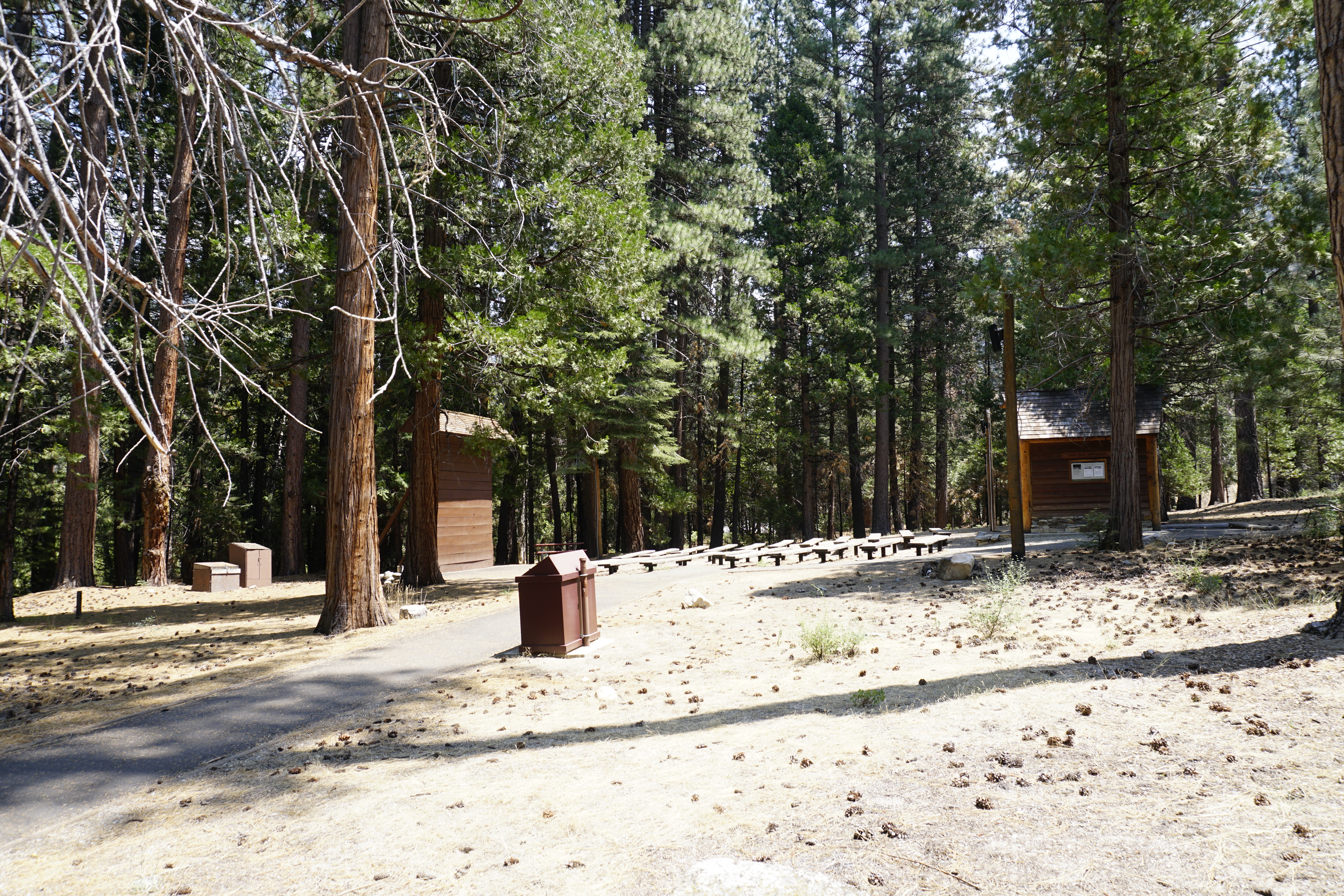
A smooth paved path leads you to the edge of a lighted outdoor amphitheater, surrounded by tall pine and incense-cedar trees. Beyond the trees you may hear a rushing river when the water level is high. To your left, and downslope, is a tall wood-planked projection wall with a white projection screen and a v-shaped roof. To the left of the screen is a campfire ring made of stones that stick up about one foot above the ground. Starting 15 feet from the wall, there are rows of 20-foot-long wood benches for seating. They are lined up in two sets of eleven, with a five-foot-wide dirt aisle running down the center. The path to the amphitheater ends by splitting in three directions. Straight ahead goes into an area cut into the sixth row, providing space for wheelchairs next to benches. The left fork continues down to and in front of the screen, providing access to another cut out for space for wheelchairs, on the closest side of the first row. The right fork goes upslope, behind the bench seating, to a small wood-planked projection building with log pole framing and a stone foundation. It has a sign that reads, "Cedar Grove Amphitheater". Two windows face the screen.
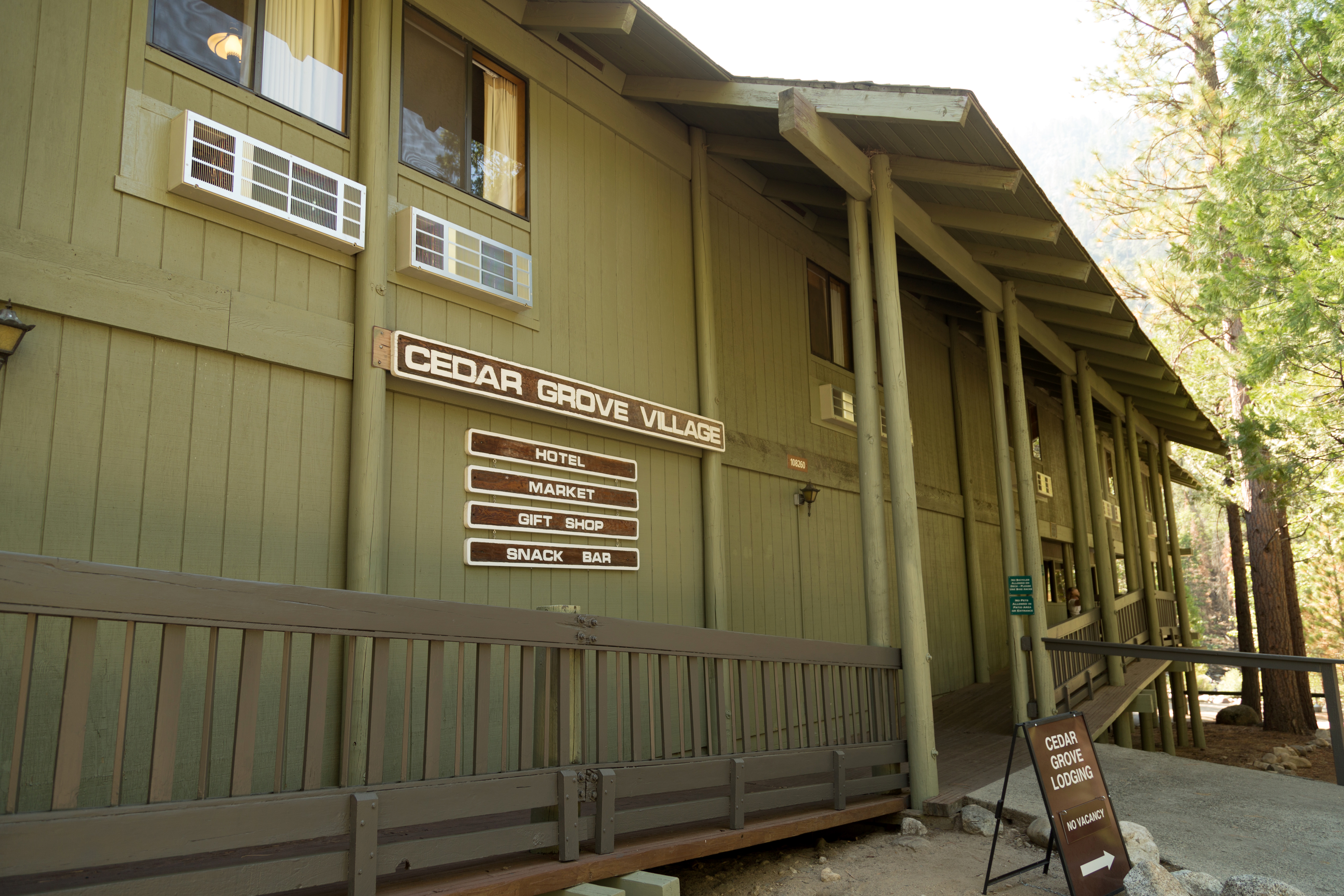
Cedar Grove Lodge is in Kings Canyon at an elevation of 4,600 feet (1402 m). Granite cliffs, the Kings River, and hiking trails are nearby. The lodge offers 21 hotel rooms, a counter-service restaurant, a market, and a gift shop. The lodge is also within walking distance of Cedar Grove's visitor center.<br /><br />Seasonally available. Please visit https://www.visitsequoia.com/ for more information.
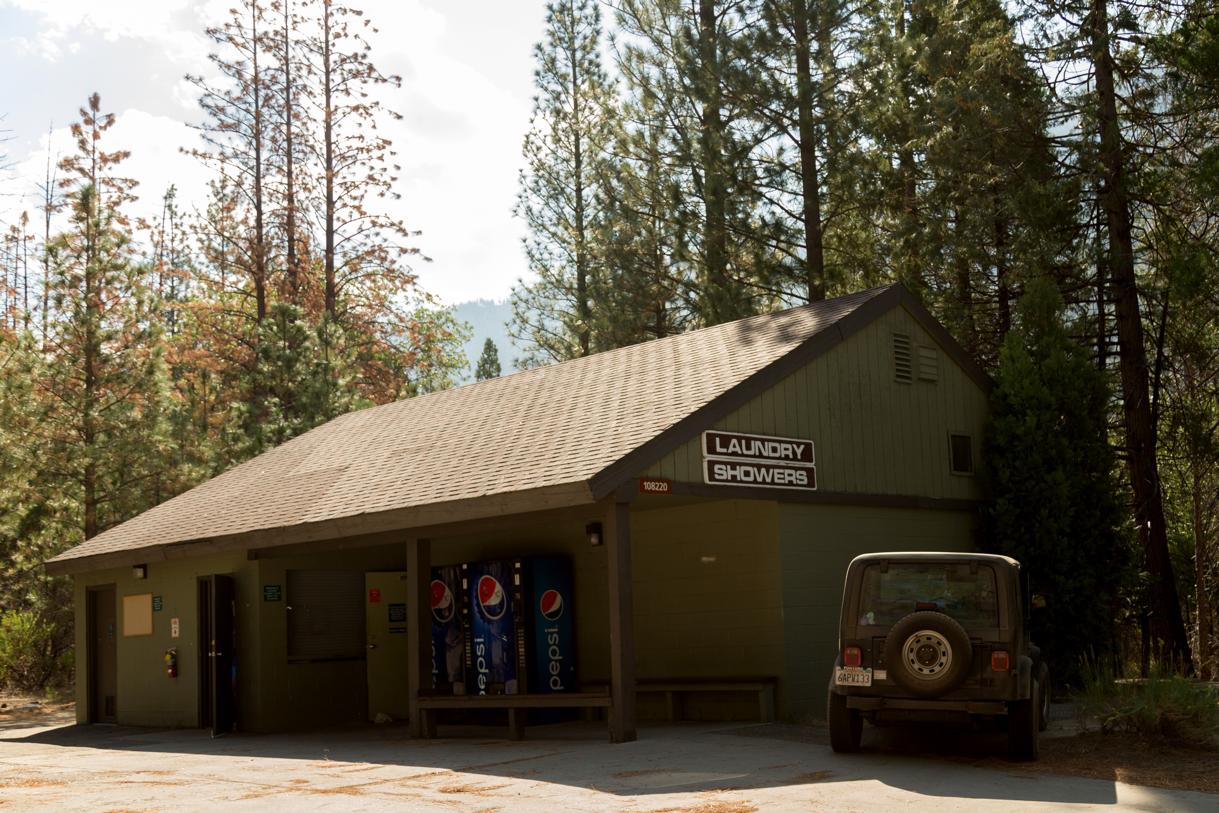
Due to COVID-19, this facility is closed until further notice.<br /><br />Coin-operated showers and laundry facilities are for lodge guests as well as campers, backpackers, and other travelers.
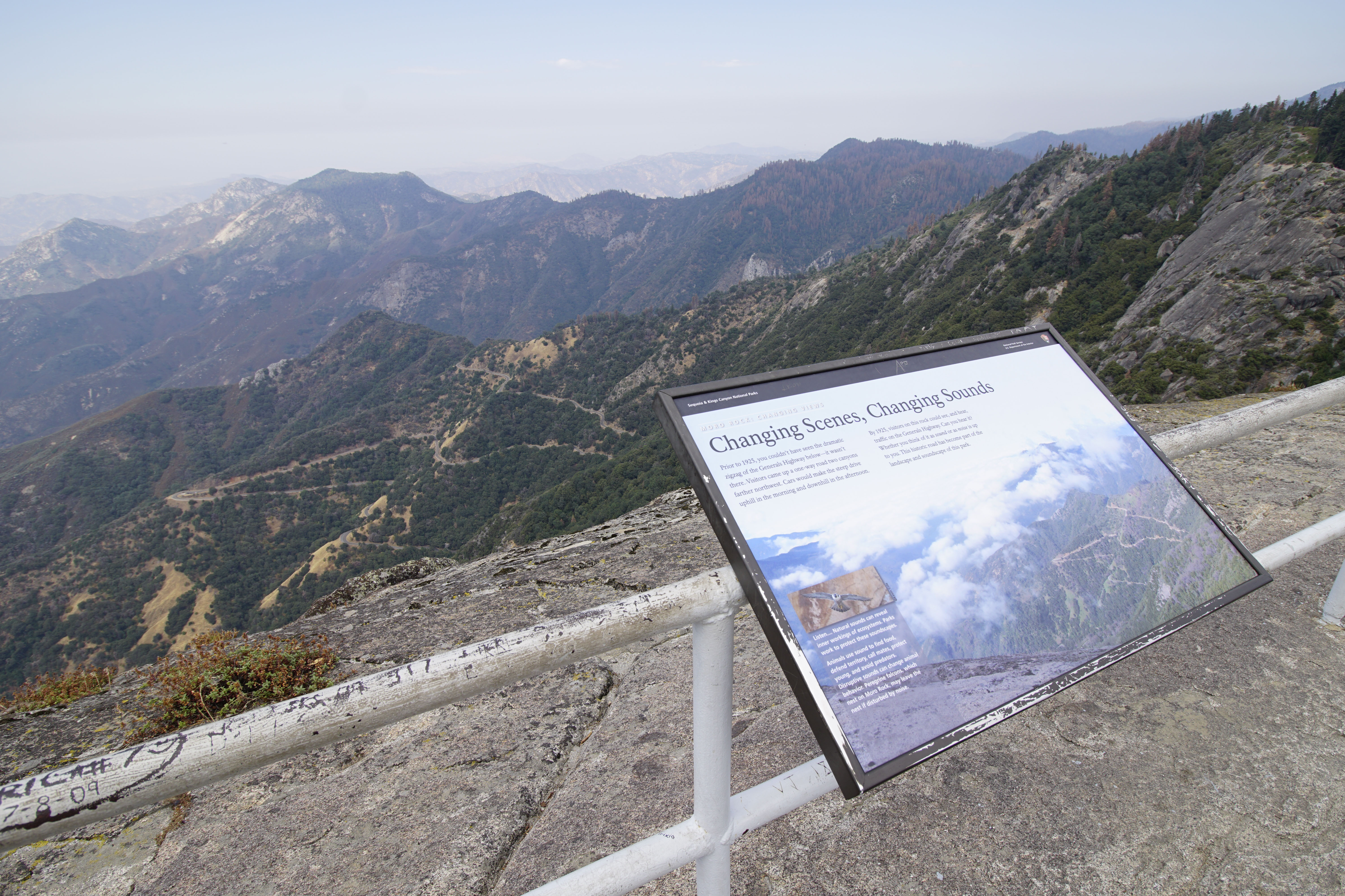
You may hear Peregrine falcons, birds that nest on this rock. A peregrine falcon's call sounds like "key, key, key, key". This wayside exhibit, titled "Moro Rock: Changing Views, Changing Scenes, Changing Sounds," discusses human-caused sounds and their effects on humans and wildlife.
You may hear Peregrine falcons, birds that nest on this rock. A peregrine falcon's call sounds like "key, key, key, key". This wayside exhibit, titled "Moro Rock: Changing Views, Changing Scenes, Changing Sounds", discusses human-caused sounds and their effects on humans and wildlife. A photo of your view - a falcon's eye view from this peak, on Moro Rock. Through the clouds below is a tree and grass covered valley, with a light brown roadway, weaving across the hillside in switchback curves. The text reads, Prior to 1925, you couldn't have seen the dramatic zigzag of Generals Highway below- it wasn't there. Visitors came up a one-way road two canyons farther northwest. Cars would make the steep drive uphill in the morning and downhill in the afternoon. By 1925, visitors on this rock could see, and hear, traffic on the Generals Highway. Can you hear it? Whether you think of it as a sound or as noise is up to you. This is historic road has become part of the landscape and soundscape of this park. A photo of a peregrine falcon flying towards us with outstretched wings. Most of its body is grey with black stripes that widen at the tips of the wings and tail. Its head appears hooded with black feathers. The beak, throat and neck are white. The tail is spread open like an upside-down fan. The caption reads, Listen... natural sounds can reveal inner workings of ecosystems. Parks work to protect these soundscapes. Animals use sound to find food, defend territory, call mates, protect young, and avoid predators. Disruptive sound can change animal behavior. Peregrine falcons, which nest on Moro Rock, may leave the nest of disturbed by noise.
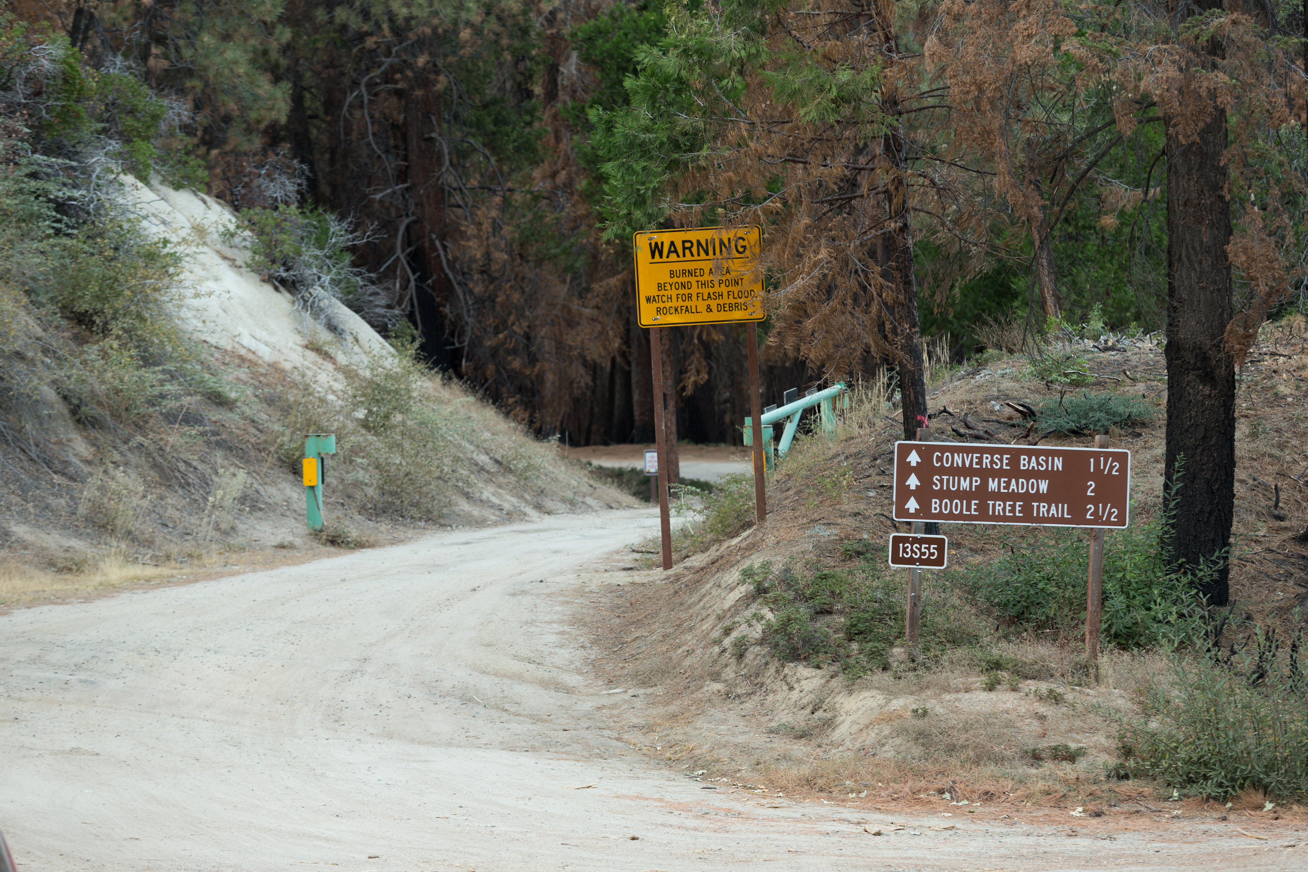
This Forest Service area 3 miles (4.8 kilometer) north of Grant Grove is part of the Converse Basin sequoia grove. From Cherry Gap, you can take roads to the Chicago Stump.
You are in a conifer forest with small trees. Some are charred, with no leaves. A brass plaque with engraved lettering on a stacked stone pedestal reads, Converse Basin Grove One of the largest stands of giant sequoias. It contained some of the finest big trees. The grove was logged as private land between 1897 and 1907. First by the Sanger Lumber Company, and later by Hume-Bennett Lumber Company, which in 1909 developed Hume Lake for a mill. Converse Basin, two miles northeast of this monument, has its own mill and narrow-gauge rail connection to the logging town of Millwood, from which lumber was sent to Sanger in the valley by flume, although they never realized any profit. The companies cut several thousand big trees and left only the largest, The Boole Tree, unfelled. The area today is part of Sequoia National Forest, which regulates all uses including logging, but none of the ancient sequoias will ever be commercially cut again. Jim Savage, Chapter 1852 and E. Clampus Vitus. October 23, 1977
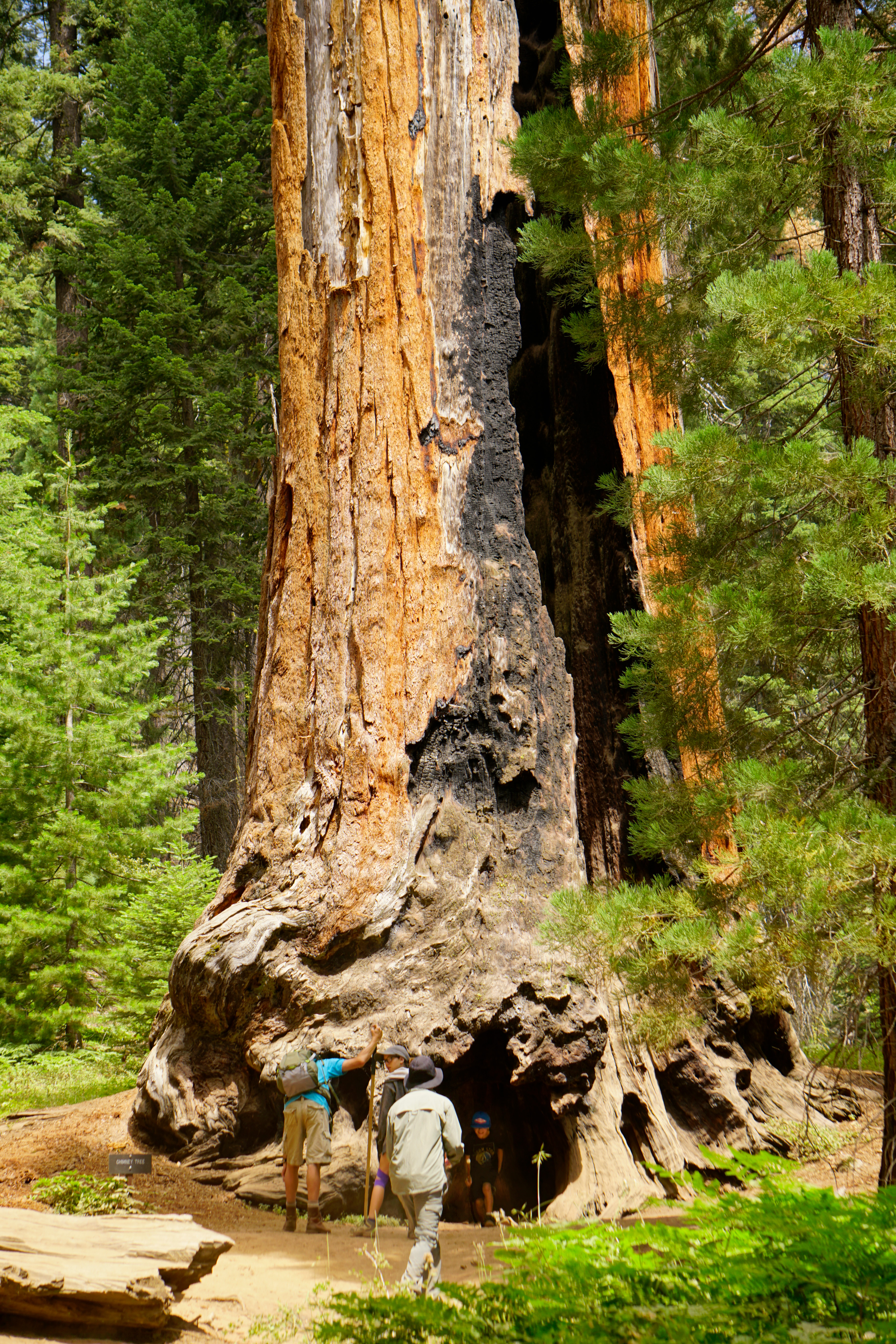
This sequoia burned in 1914. For over a century, the remaining trunk has slowly weathered but remains in remarkably good condition. What do you think it will look like in another hundred years?
Before you is the standing trunk of a mature sequoia. Much of the bark is no longer there, revealing weathered, gnarled wood. The top of the trunk is jagged and charred, and the tree has no leaves or branches. A vertical opening along one side extends from the ground to the top of the trunk, creating a space large enough for a person to walk through. Another opening in the base is wider but lower. A small metal sign reads "Chimney Tree."
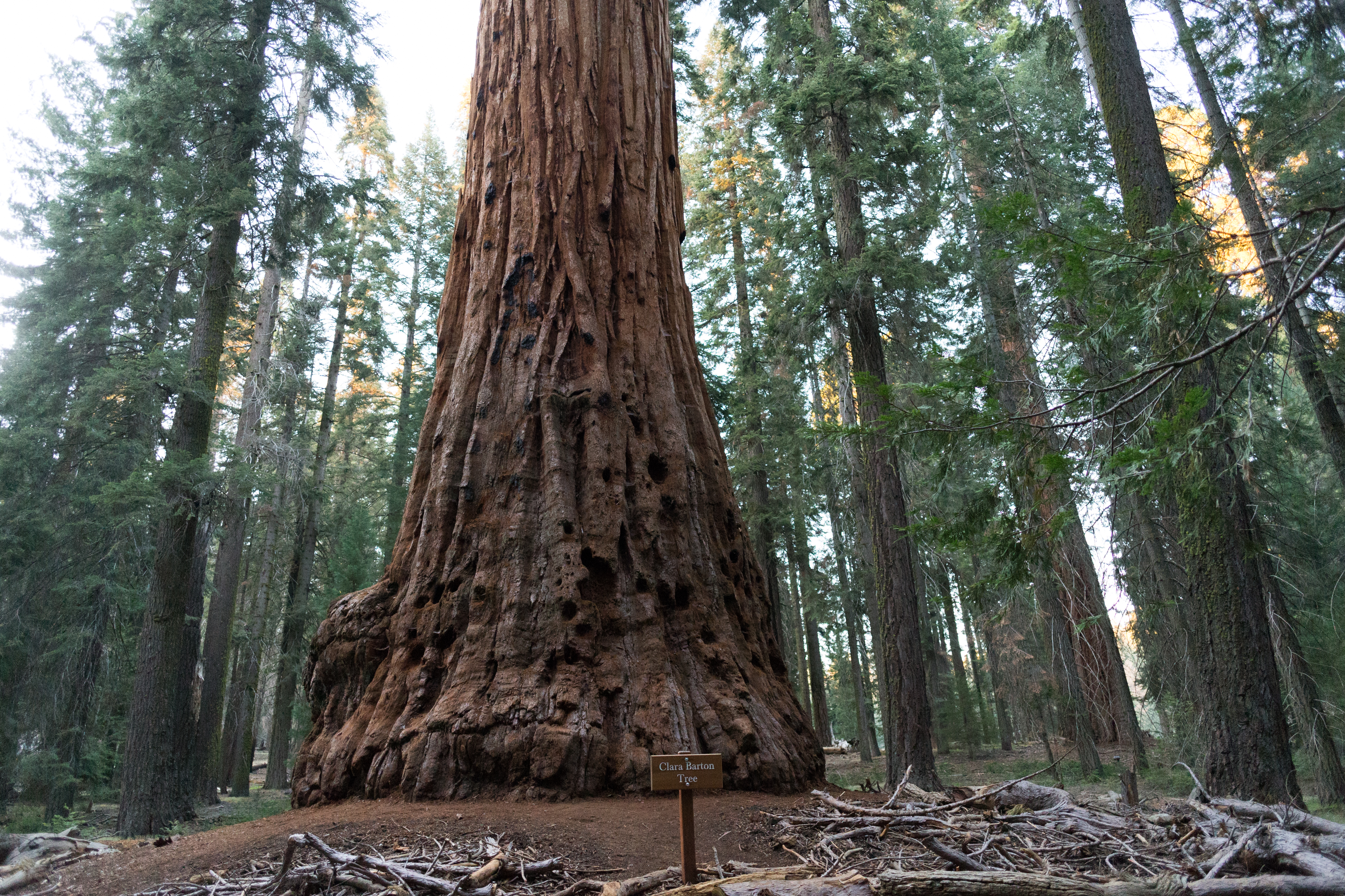
Trees throughout Sequoia and Kings Canyon National Parks are named for a variety of extraordinary people. The Clara Barton Tree, near the beginning of the Big Trees Trail, honors this Civil War nurse, a teacher, and patent clerk and the founder of the American Red Cross, who lived from 1821 to 1912. It is one of only two trees named for women. The other, the Susan B. Anthony Tree, can be seen from this trail if you know where to look. Clara Barton's contemporary, Susan B.
You are in the Giant Forest, before you is a gigantic sequoia tree. At the base of the massive trunk is an embossed wood sign that reads, "Clara Barton Tree". If you walk to the tree you will need to be careful because there are many fallen branches around it. The trunk of the tree has a fibrous, shaggy bark. The base has irregular curves. Above the curves, starting at about five feet up, there many holes peppering the trunk, each about one foot across, about the size of a bowling ball. If you reach into a hole, the walls of the hole have deep gouges and the bottom is covered with a layer of shredded bark. There are thick spider webs in several of these holes.
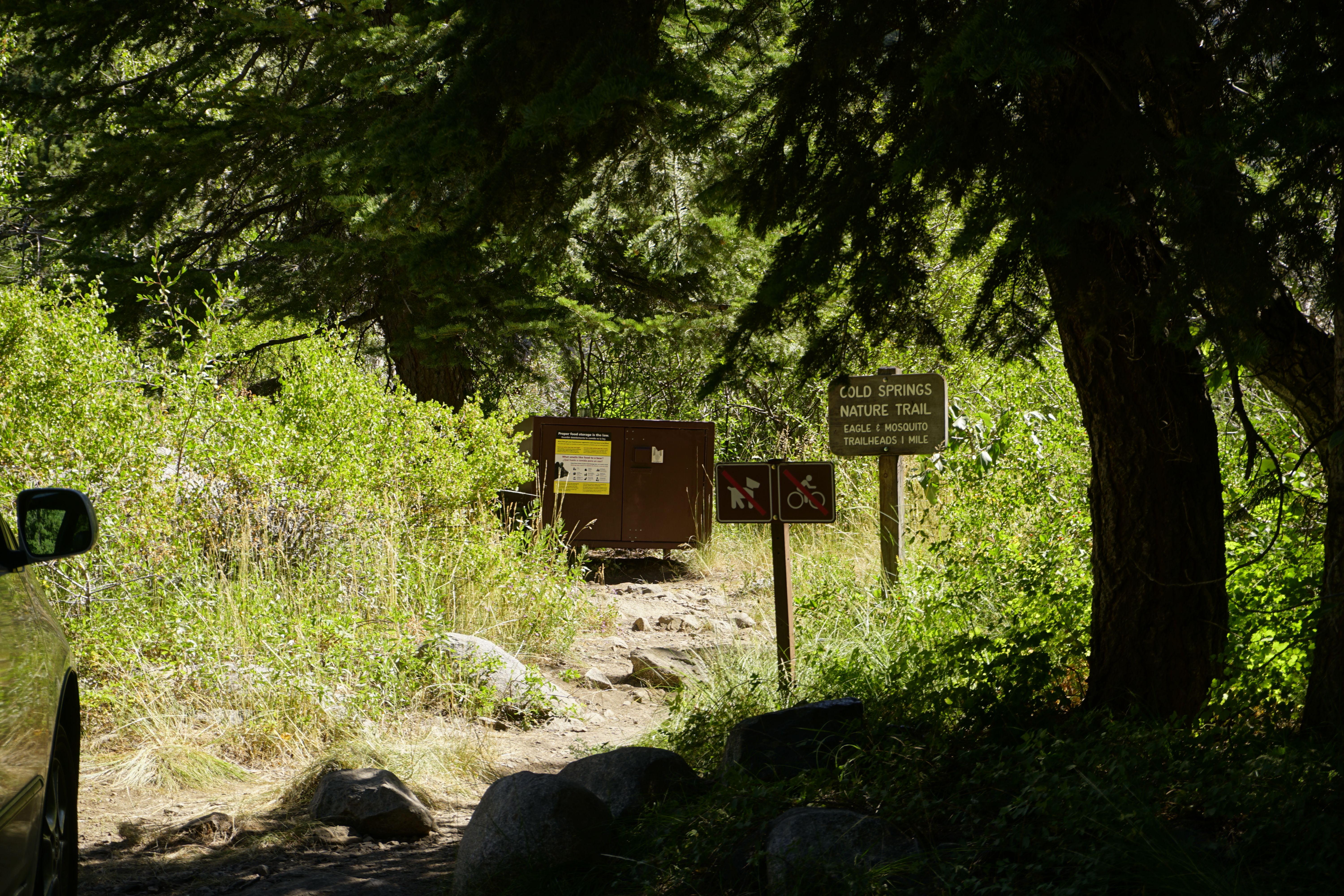
This trailhead orientation panel shows a map and images of Cold Springs Nature Trail.<br /><br />Cold Springs Nature Trail is 2.0 miles round-trip (3.2 kilometer) at an easy incline. It travels through meadows and aspen groves to the site of the former mining town of Beulah. The trail features interpretive panels, which give more information about your surroundings. This trail is for day-use only; overnight camping is available at the Cold Springs Campground.
Close-up of a green meadow with tiny purple and yellow blossoms, and red feathery flowers. A 1 mile (or 1.6 km) hike for beginning hikers.
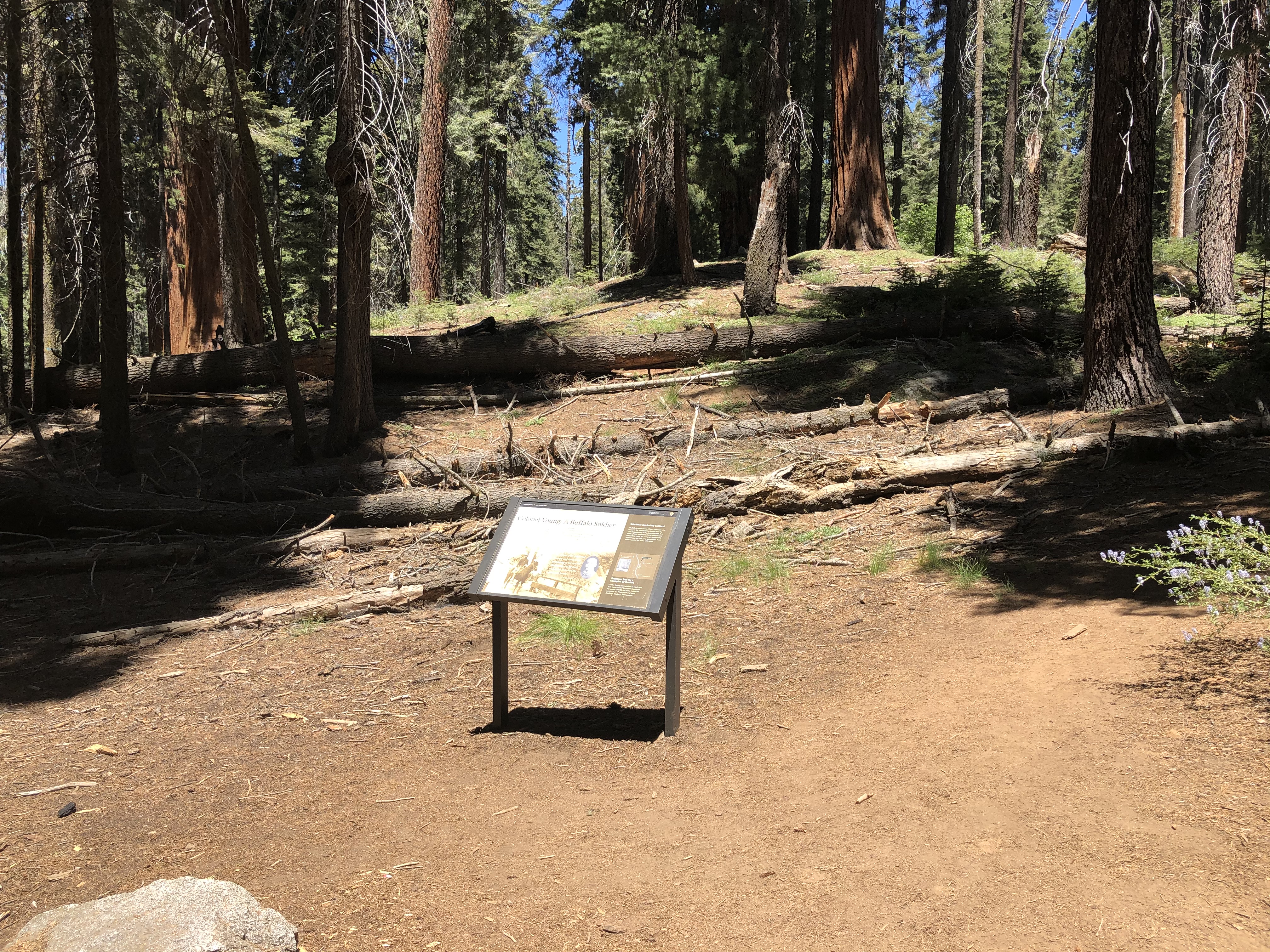
This wayside exhibit, titled "Shaping a Park, Colonel Young: A Buffalo Soldier," shows photos and text about Colonel Charles Young.
The View: You are surrounded by large sequoia trees. Their green canopy provides welcome shade. The text explains that the road to Moro Rock is part of the legacy of America's first black national park superintendent. Captain Charles Young, a West Point graduate, commanded the cavalry units of Buffalo Soldiers who were assigned here in 1903. Before there were park rangers, the military guarded national parks. Young's troops were the first African-Americans to do so. In just one summer, he and his men completed many projects. They took some of the first vital steps towards long- term protection of this park. Captain Young later earned the rank of Colonel, and became a national figure. A sequoia named for him stands a short distance along the trail. A black and white photo of a man mounted on a horse standing on a wooden bridge. His saddle rests on a thick blanket. The saddle's foot strap has a leather flap that wraps around the ankle of his boot. He is dressed in a dark long-sleeved shirt and light-colored pants, and wears a brimmed felt hat. He wears long leather gloves that come up to his forearm. His pants are tucked into buttoned knee boots. In this rare 1903 photo, a Buffalo soldier poses on the Marble Fork Bridge in Sequoia National Park. A black and white photo portrait of Charles Young. He is clean shaven. He wears a white shirt under a buttoned jacket. On his collar are the letters "U.S." and a U.S. Calvary pin of two crossed swords with a number "9" in the center. A quote by Charles Young next to his portrait reads, "The people of the adjoining country and tourists are awakening to the benefits and beauties of the park and desire to protect the game and Forest...." Text to the right reads, Who were the Buffalo soldiers? Buffalo soldiers were African Americans who served in the United States cavalry after the Civil War, primarily in the American West. It is believed that American Indians- who revered the buffalo- gave the name and tribute to the soldiers' courage, skill, and appearance. These soldiers carried the name with pride.
This picnic spot near the Grant Grove campgrounds and Visitor Center offer a good slope for sledding in the winter.
This shaded area has conifer trees and a few low rock boulders. The ground is flat near the picnic area. Picnic tables, made of thick slabs of wood on raised wooden bases, provide easy access. A nearby flat grassy area offers an open area for relaxation and play. Beyond that are low hills with scattered trees.
Sequoia groves grow within the larger conifer--or conebearing--forest. Their neighbors are as important, fascinating, and beautiful as sequoias -- just not as big!<br /><br />This wayside exhibit, titled "Community", shows four different types of conifer trees.
This wayside exhibit, titled "Community", shows four different types of conifer trees. The View: The forest is canopied with pine, incense-cedar, fir, and, of course, sequoia trees. The text reads, Community Look at the canopy above you. This forest is a diverse neighborhood that supports more than sequoias. How many different kinds of trees can you count? Look for differences in cones, leaves, and silhouettes. Protecting sequoias means safeguarding this entire forest. Across the exhibit are four indented rectangles, each showing a different tree. Each rectangle has a raised cone outline on the left. Next to it is a raised outline of the shape of the leaves (also called needles). Both of these are in true scale. There is a silhouette of the mature tree on the right of each rectangle, but it is not tactile or to scale. Going from left to right the trees are: 1. Incense-cedar, or Calocedrus decurrens. The raised cone does not have a typical cone shape; its two outer scales open into a v shape, leaving a thin central structure inside the v. The shape next to it illustrates the thick, short, flattened leaves on a cluster of tiny branches, forming a broom-like spray. The tree has a long thin trunk with a conical top. The text reads, Often mistaken for a sequoia, its leaves are flatter and its bark is harder and rougher. 2. Giant sequoia, or Sequoiadendron giganteum. You can feel a raised cone outline on the left. The cone is brown, with dark ridges crisscrossing it. The leaf to the right has what looks like long thin twigs, covered in small overlapping green scales, which are the needles. These needles are tiny and hard to see. The text reads, Its short sharp needles overlap each other, completely covering the twigs. The tree has a tall thick trunk, with short stubby branches starting two-thirds of the way up. 3. White fir, or Abies concolor. The cone stands upright on the branch, above the short needles that grow along the sides of the branches. Horizontal ridges tightly crisscross the cone. Inside the raised leaf outline, the photo shows needles in a row on either side of the twig. The tall narrow tree has branches pointing downward. The text reads, Needles grow in neat rows along the twigs. Cones grow upright and fall apart while still on the branch. 4. Sugar pine, or Pinus lambertiana. Inside the raised cone outline, the photo shows the cone opening. Dozens of fan-shaped segments, like scales on a fish, are open, having released the seeds within. The raised leaf outline on the upper right shows a cluster of five long thin needles, coming out of a central point. The text reads, Long slender branches extend far from the trunk. Needles grow in bunches of five. The Braille information provided on this exhibit has already been explained in this Audio Description.
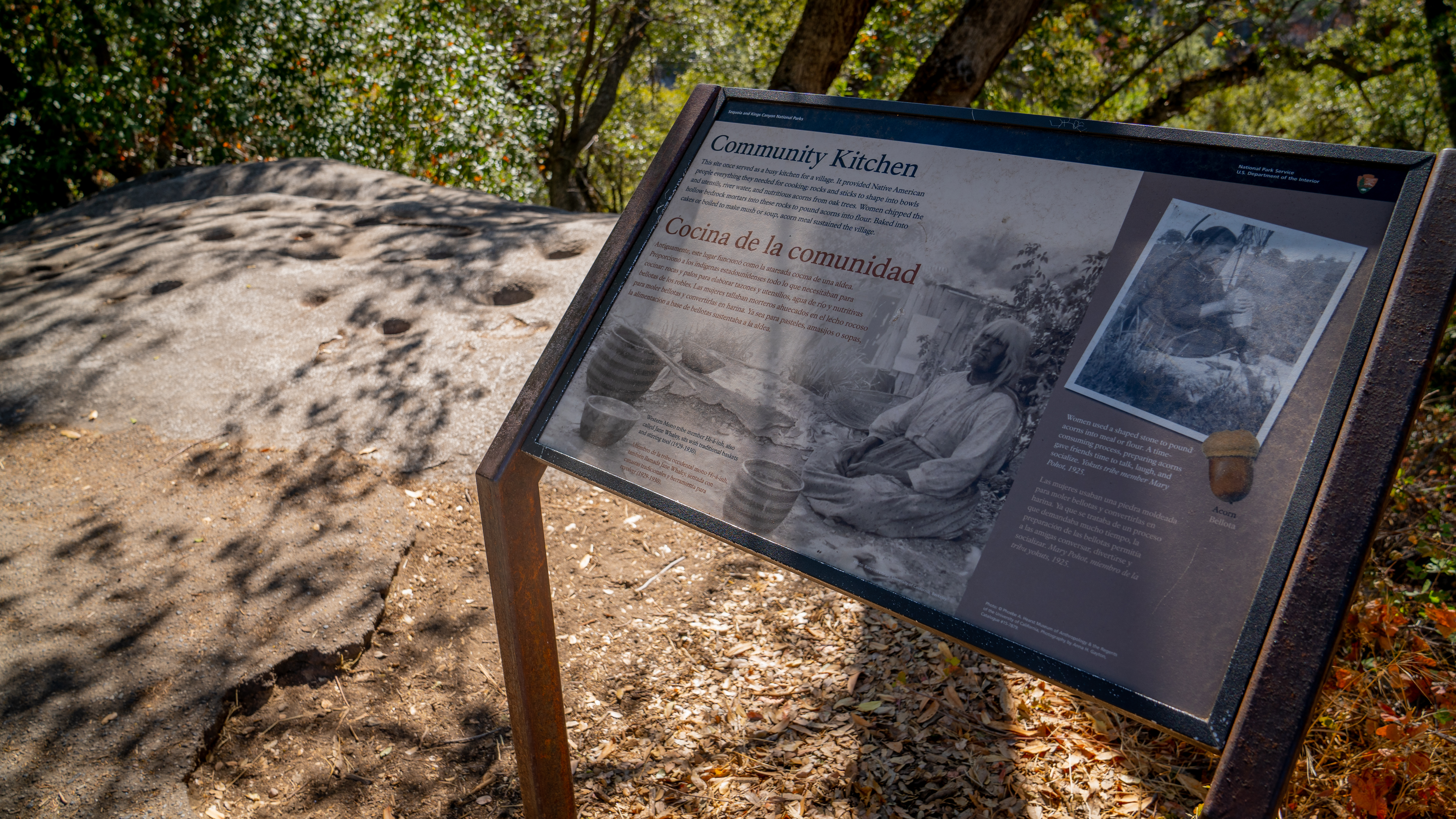
This wayside exhibit, titled "Community Kitchen," shows how American Indian women prepared acorns.
The View: To the left of the wayside exhibit is a large rock with mortar holes embedded into it, where Native American people once pounded acorns into meal. Each hole is between 4 and 12 inches wide, in a conical shape. On the left side of the rock, is a Bay Laurel tree, with long, dark green, pointy leaves. The leaves are aromatic when crushed. Overhead are Canyon Live Oak trees, with oval leaves that are jagged and pointy on the outer edge. A large Sumac bush on the right has olive green leaves that are oval with a pointed tip. From this site, you can often hear the river flowing through the canyon below this exhibit. The text reads, This site once served as a busy kitchen for a village. It provided Native American people everything they needed for cooking: rocks and sticks to shape into bowls and utensils, river water, and nutritious acorns from oak trees. Women chipped the hollow bedrock mortars into these rocks to pound acorns into flour. Baked into cakes or boiled to make mush or soup, acorn meal sustained the village. The main image is a black and white photo of an older American Indian woman seated crossed legged in a printed dress, with an apron around her waist. Around her are three deep rounded baskets made of woven grasses or reeds. Two are striped and one has a zigzagged pattern. Two long narrow sticks rest atop the largest basket. To her right is a large cloth laid out on the ground. Two shallower plain baskets lie on the cloth. A building made of upright slatted wood boards is seen behind her. The caption reads, Western Mono tribe member Hi a inh, also called Jane Whaley, sits with traditional baskets and stirring tool (1929 to 1930). Another black and white photo shows a middle-aged American Indian woman at work. Her dark hair pulled back in a bun and she's wearing a dress with a ruffled collar, seated on a blanket on a large flat rock. With arms bent, she holds a conical shaped stone the size of a bread loaf above a round hole in the stone next to her. The caption reads, Women used a shaped stone to pound acorns into meal or flour. A time-consuming process, preparing acorns gave friends time to talk, laugh, and socialize. Yokuts tribe member Mary Pohot, 1925. Below there is an image of an acorn- a brown thumb sized oval nut with a light brown textured "cap".
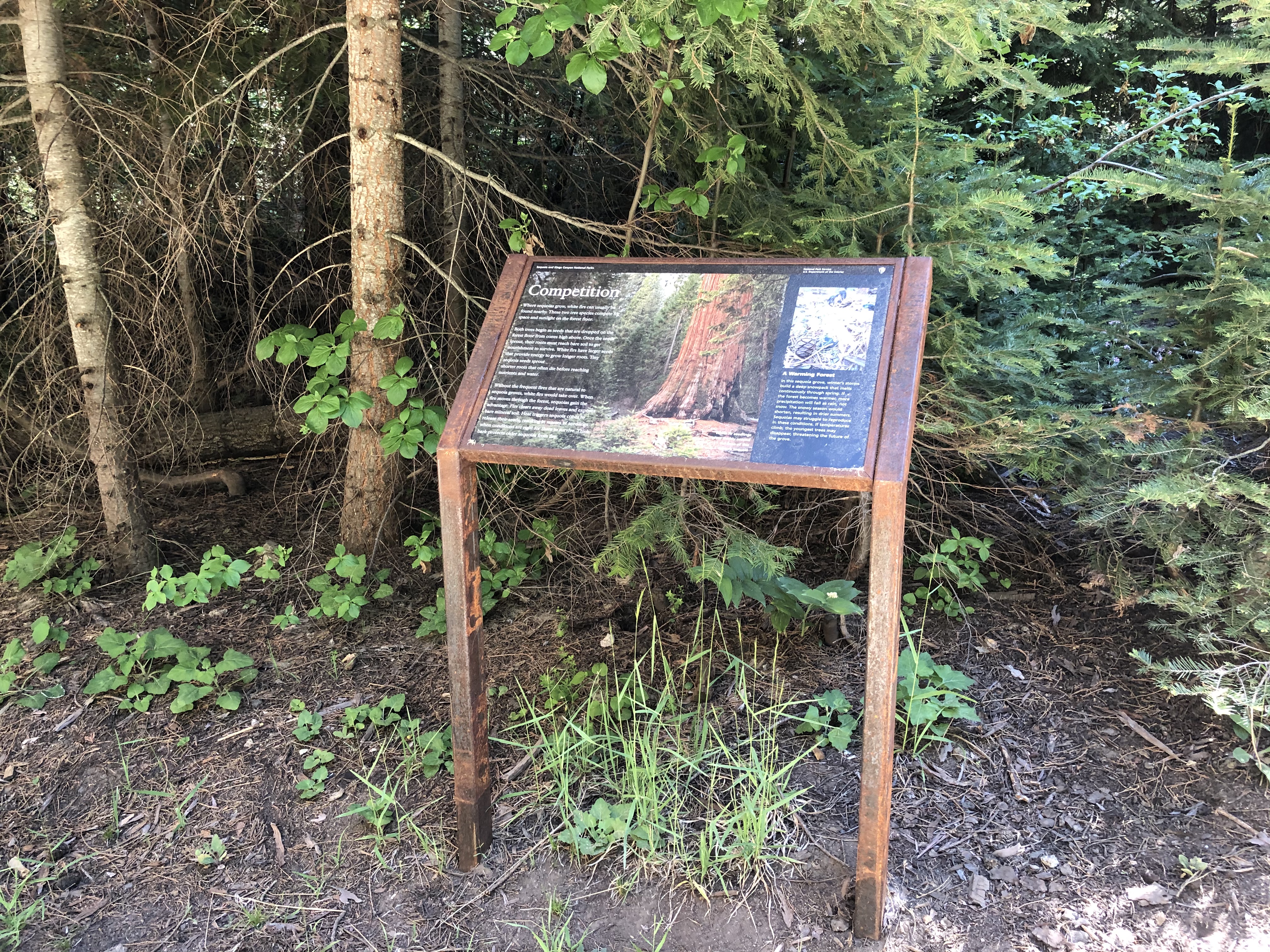
This outdoor exhibit, titled “Competition,“ shares information about giant sequoia ecology.
This outdoor exhibit panel is titled, "Competition" and features two photos with captions and additional text about giant sequoia ecology. This exhibit features a photograph of the brown trunk, a very large trunk of a mature giant sequoia tree. Other mature firs trees are seen in the background, and a cluster of small fir seedlings are in the photo’s foreground. The photo’s caption reads, “White fir seedlings grow thickly around the base of this mature sequoia.” The exhibit text reads, “Where sequoias grow, white firs can usually be found nearby. These two tree species compete for space and sunlight on the forest floor. Both trees begin as seeds that are dropped on the forest floor from cones high above. Once the seeds sprout, their roots must reach bare soil to get nourishment to survive. White firs have larger seeds that provide energy to grow longer roots. Tiny sequoia seeds sprout shorter roots that often die before reaching nutrients and water. Without the frequent fires that are natural to sequoia groves, white firs would take over. When fire moves through the forest, sequoias gain the advantage. Fire clears away dead leaves and exposes bare mineral soil. Heat triggers sequoia cones to release their seeds, resulting in masses of seedlings when conditions are right for them to survive. Thick bark protects older sequoias from fire. To the right of the giant sequoia photograph is a smaller photo of a small, brown-tinged sequoia seedling and a sequoia cone, found atop incense cedar twigs and plant material on the forest floor. The photo’s caption reads, “A Warming Forest“, “In this sequoia grove, winter’s storms build a deep snowpack that melts continuously through spring. If the forest becomes warmer, more precipitation will fall as rain, not snow. The snowy season would shorten, resulting in drier summers. Sequoias may struggle to reproduce in these conditions. If temperatures climb, the youngest trees may disappear, threatening the future of the grove.”
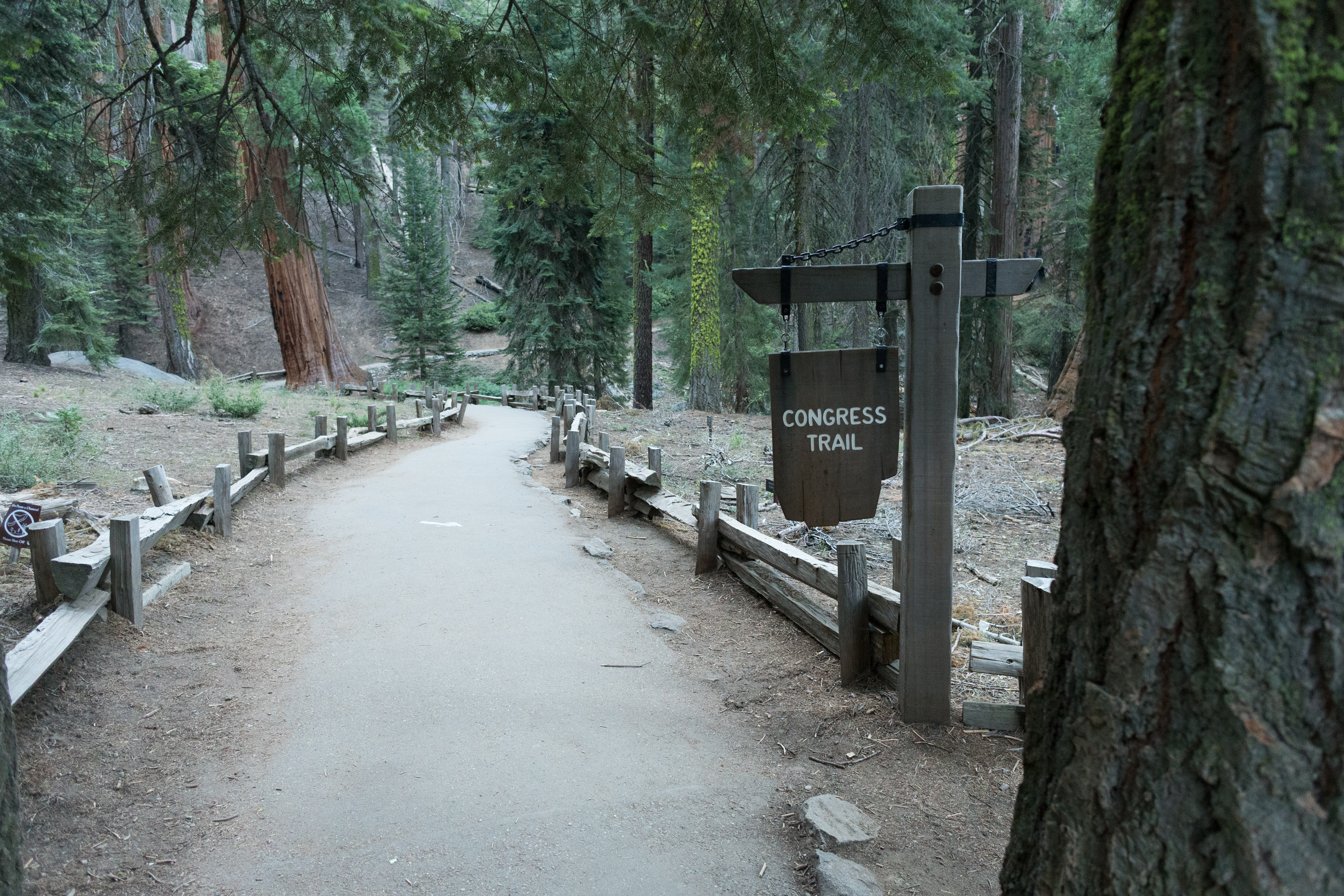
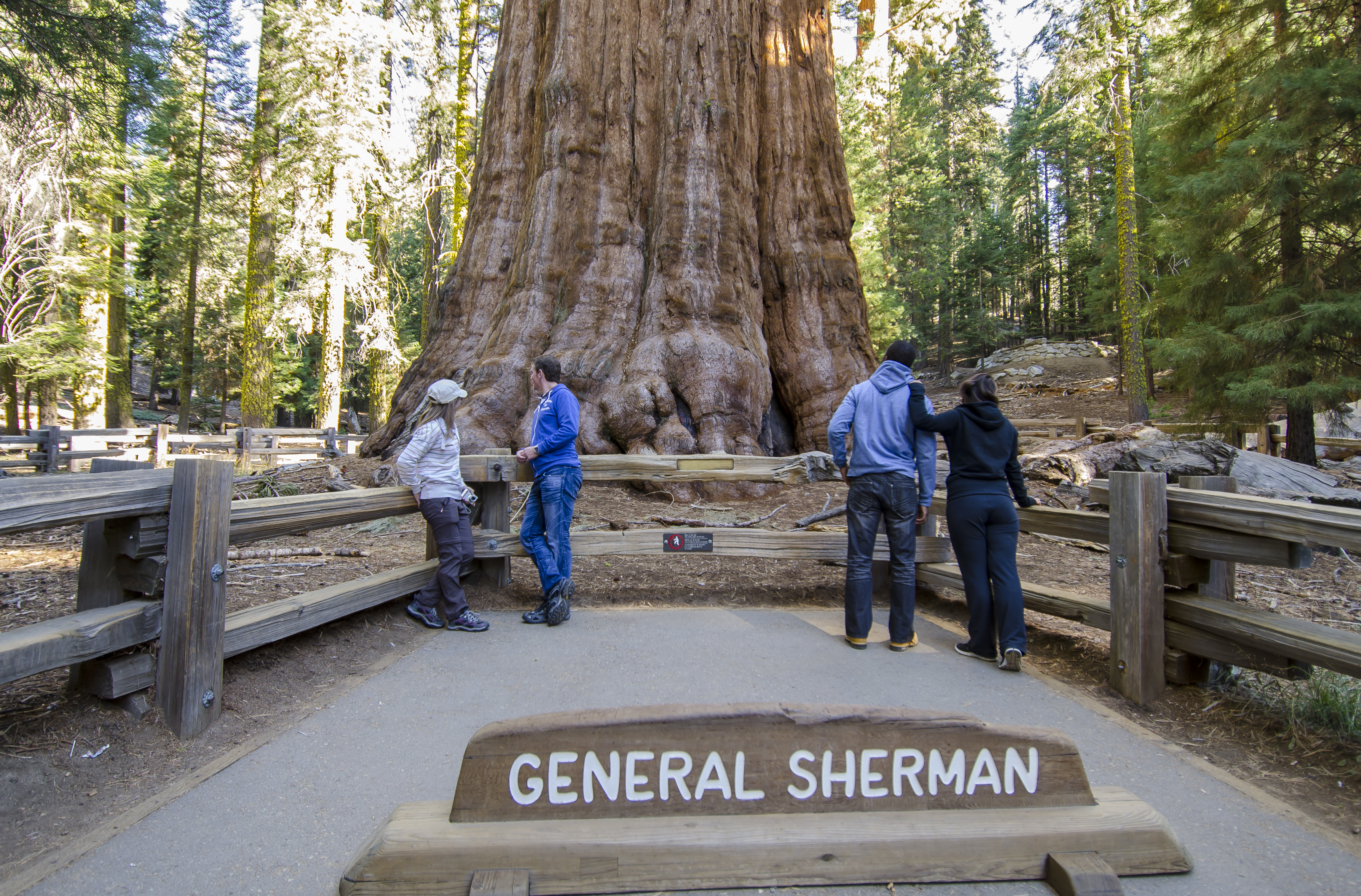
This trailhead orientation panel shows a map and images of the Congress Trail. Congress Trail is a 2.7 mile round-trip lollipop-shaped trail on a gentle, paved incline. It begins near the General Sherman Tree, the largest living tree on Earth. Along the path, you'll also see excellent examples of mature sequoias, including the House and Senate groups, and the President Tree.
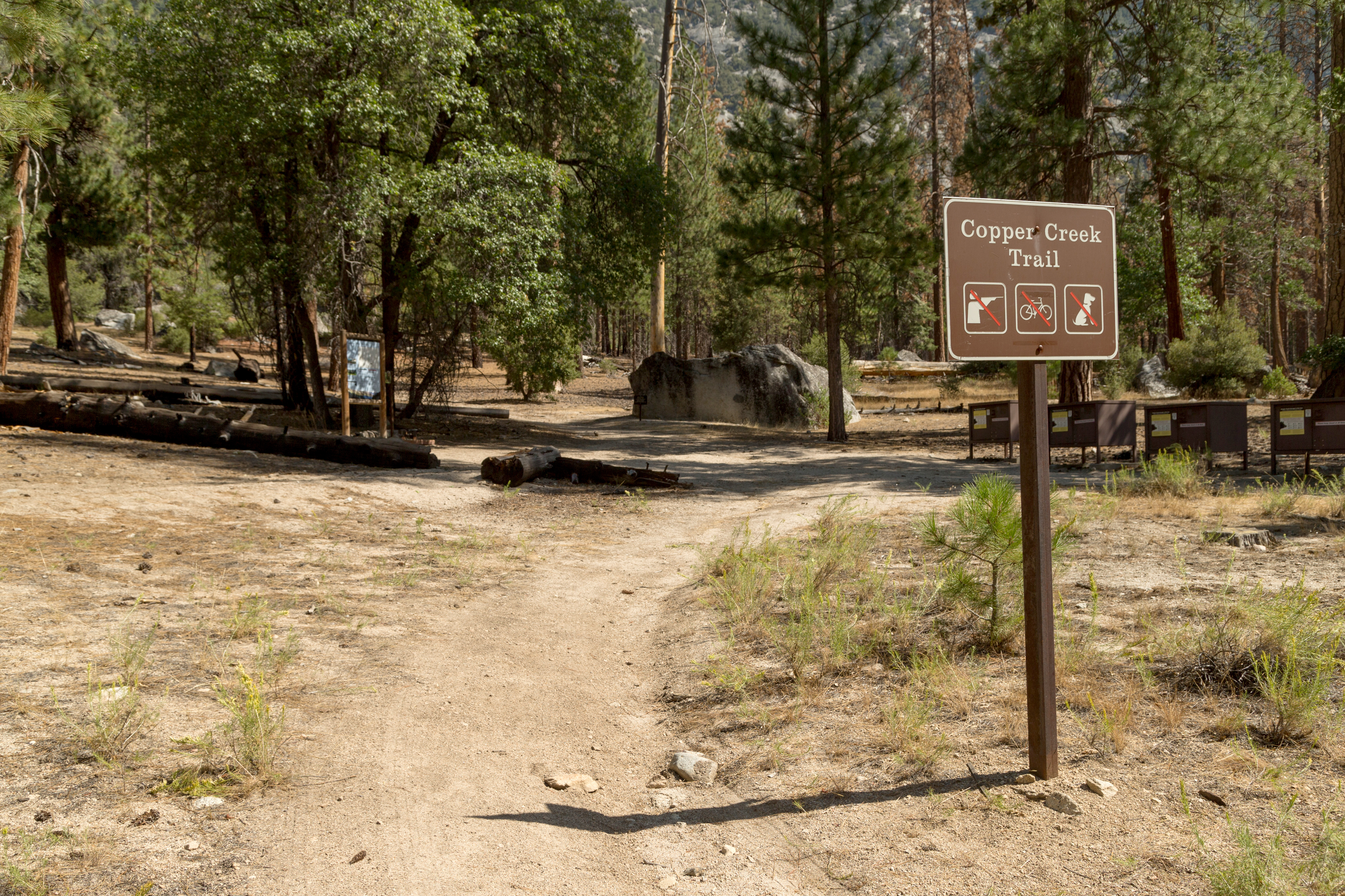
This trailhead orientation panel shows a map and images of the Copper Creek Trail area.Copper Creek Trail is 10 miles one-way (20 miles round-trip) at a difficult incline. The trail travels through several aspen forests and meadows, ending at Granite Lake, a stop that offers beautiful vistas of Mount Hutchings, Goat Mountain, and Comb Spur. The first campsite along the trail is at 4 miles at Lower Tent Meadow. This is a hot, steep climb, so you may want to plan your hiking fo
The text reads, Spectacular views of the Kings Canyon reward those who climb this trail. Lower Tent Meadows offers a welcome rest halfway to the top. After ascending steeply over 5,000 feet (or 1525 m), the trail levels out in Granite Basin. Like most park trails, Copper Creek Trail leads into designated wilderness. One of the highest forms of protection for public lands, wilderness preserves untamed landscapes for you to experience. A photo of a grassy flat area, surrounded by rocky hillsides dotted with conifers. A steep white mountain range is seen in the distance. The caption reads, Granite Basin and Granite Lake. 1.8 miles (or 12.9 km) to The Lip. Elevation: 10,348 feet (or 3,152 m). "The Lip" marks the entrance to Granite Basin. Granite Lake lies about 2 miles (or 3.2 km) farther. Monarch Ranger Station, which is intermittently staffed, is a short way down the trail near Granite Pass. A photo of a meadow of green grass and shrubs, lined with tall trees. Steep mountain walls rise beyond the trees. The caption reads, Simpson Meadow. 22.8 miles (or 36.7 km) one way. Elevation: 5,990 feet (or 1,826 m). After Granite Pass, the trail passes through forested canyons, and then descends quickly to the Middle Fork of the Kings River and Simpson Meadow. Side trails along the way lead to State and Horseshoe Lakes. A map shows the location of the Copper Creek Trailhead, The bottom photo shows a rocky slope dotted with trees. The top of a mountain range, in the distance, is covered with snow. The caption reads, A view from Copper Creek Trail. A quote by Willa Cather, "We come and go, but the land is always here."
This wayside exhibit, titled "Correct Climate," shows how temperature changes can affect sequoia growth.
The View: To your left are the grasses of Round Meadow and to your right are the sequoias of Giant Forest. The text on the panel reads, Correct Climate Sequoias need a climate like the Giant Forest has now, lots of precipitation but not very cold temperatures. Yet this area was not always ideal sequoia habitat. This meadow reveals that, until about 4,000 years ago, very few sequoias grew here. It was either too dry or too cold. This meadow records the history of local climate. Over thousands of years its soil formed in layers as plants decomposed. Scientists can identify these plants and know what type of climate they require. That tells us what the climate was like when they were growing here. A background photo, taken from the meadow, shows a dense line of giant sequoias against a dark sky. An illustration, layered on top of the photo, shows a cross section of the meadow's soil, with bright green grass on top of a brown layer, a dark green layer below that, then a grey layer at the bottom. The text reads from top to bottom, Meadow Layers Reveal Sequoia's Past Bright green layer: Ideal for Sequoias. Today to 4,000 years ago. There is enough rain and snow to support sequoias and their forest neighbors. Brown layer: Too Dry. 4,000 to 12,000 years ago. Sagebrush and dry climate pines grew then. Dark Green layer: Too Cold. Before 12,000 years ago. An ice age dominated the landscape. A glacier 500 feet thick (or 152 m) filled the canyon at Lodgepole just north of here. Cold tolerant plants that lived here then now grow 3,000 to 4,000 feet higher in elevation. Grey layer: Solid Bedrock.
The Crescent Meadow Picnic Area is 2.6 miles from the Giant Forest Museum, near Moro Rock and several trailheads. The picnic area rests at the edge of a lush meadow.
You are standing before a large crescent shaped meadow, a wide-open swath of greenery circled by a dense forest of towering sequoia trees and conifers. Filled with grasses and ferns, the meadow view changes dramatically with the season. If you're here in the spring and early summer, it is green and lush with burgeoning wildflowers such as violet lupine, deep red Indian paintbrush, and green corn lilies. In late summer, a brownish tinge comes over the floor of the meadow as the area starts to dry. Autumn brings a splash a yellow from goldenrods. In the winter, the meadow is often snow covered.<br /><br />Ravens, golden-crowned kinglets, mountain chickadees, and warblers frequent the meadow; listen for their calls. You may even hear woodpeckers drilling holes in trees.<br /><br />A rectangular carved wooden sign, on two supporting wood posts, with white and orange embossed lettering reads,<br /><br />Crescent Meadow <br /><br />A quote by John Muir, <br />"Gem of the Sierras"
This Sequoia Shuttle stop is located at Crescent Meadow, one of the larger meadows in these parks and the starting point for several hikes. Sequoia Shuttles run from late May until early September. Riding the shuttle helps you avoid having to find parking, which can be limited. It also reduces air pollution within our parks. Shuttles within the park are free; round-trip shuttles from Visalia are $20, which includes the park entrance fee.
This wayside exhibit, titled "Cross Section Story" provides information about the tree section in front of you.
The View: A giant cross section of a sequoia trunk stands before you, tilted up, like a wall, behind the wayside panel. The section is about 15 feet in diameter. A thick crack runs through its center. Thick bark is seen on the top but has been worn away lower down. You can feel how uneven the outer edge of the trunk is. Thin cracks run roughly parallel to the outer edge. On the wood around the outer edges of these cracks, you may feel very subtle ridges, running perpendicular to the cracks. Each ridge represents one year of growth after the fire, as the tree wraps around the edge of the scar to cover the opening, and protect the tree. The text reads, Cross-Section Story This slab from the stump of a giant sequoia tells a story of fire and survival. The annual growth rings show that the tree lived about 2,210 years. Marks within some rings show that, during that time, at least 80 different fires burned hot enough to leave a scar. Mature sequoias survive all but the very hottest fires. Thick, fibrous bark insulates the tree from killing heat. The bark holds very little sap or pitch, so it is not very flammable. As you can see in the slab, even if fire does penetrate the bark on occasion, it doesn't often kill the tree. Mature sequoias live quite well despite large fire scars. A photo of the trunk section. The caption reads, This slab was sliced from the base of a giant sequoia that grew not far from here. In 1950 the park cut the tree down because it threatened to fall on rental cabins. Recognizing the hazard to both visitors and trees, the park eventually moved overnight facilities out of the sequoia grove. Visitors no longer risk having sequoias fall on them while they sleep. Two-thousand-year -old sequoias no longer risk being felled because they lean over little cabins. An inset circular photo shows a close up of the trunk section, entitled, Scars and Healing It shows two dark curved cracks. The cracks are highlighted in red and the wood outside the cracks is highlighted in yellow. The caption for the red highlights reads, These scars reveal how many fires were hot enough to damage the word beneath the bark. A typical sequoia here has survived several such fires during each century of its life. The caption for the yellow highlights reads, Notice wider growth rings next to the cracks. After fire, sequoias often grow faster for a few years. It may be due to decreased competition for nutrients and water for several years after surrounding plants are burned away. A black and white photo of this sequoia tree starting to lean to one side as loggers cut the base. The caption reads, The tree from which this slab was cut was photographed as it fell in 1950.
The Cedar Grove Visitor Center, located in a small historic cabin beside the South Fork of the Kings River, sits in a mixed coniferous forest at an elevation of 4,600 feet (1,400 m) in Cedar Grove. It is approximately 30 miles east of Grant Grove Village along CA-180. Stop by for park information, maps, and brochures. Nearby amenities include potable water, accessible restrooms, and venues for ranger-led programs. The visitor center operates only during the summer season; operating hours and dates may vary.
The Foothills Visitor Center is one mile east of the Ash Mountain Entrance on Generals Highway. Stop by for information, maps, books, gifts, water, and restrooms. Explore exhibits on foothills ecology and human history. Open year-round, except during weather, emergency, or operational closures. Operating hours vary seasonally. During the wilderness permit non-quota season, self-issue wilderness permits are available outside the Wilderness Office building behind the visitor center.
The Giant Forest Museum is in a historic market building in the Giant Forest sequoia grove at 6,500 feet (1,980 m), about 16 miles north of the Ash Mountain Entrance on Generals Highway. Stop by for information, maps, books, gifts, water, and restrooms. Explore hands-on exhibits about giant sequoia ecology. Open year-round, except during weather, emergency, or operational closures. In the wilderness permit non-quota season, self-issue permits are available in the museum plaza.
The Kings Canyon Visitor Center is located in Grant Grove Village, about three miles north of the Big Stump Entrance Station, at 6,500 feet (1,980 m). Stop in for maps, information, books, gifts, water, and restrooms. Explore exhibits on giant sequoias, Kings Canyon, and the High Sierra, and watch a short park film available in English and Spanish. Operating hours may vary. During the wilderness permit non-quota season, self-issue permits are available at the permit station in the visitor center plaza.
Renovated in 2023, the Lodgepole Visitor Center is located in the coniferous forests at an elevation of 6,700 feet (2,040 m), about 21 miles north of the Ash Mountain Entrance Station on Generals Highway. Stop by for information, wilderness permits, park films, maps, books, gifts, water, and restrooms. Explore immersive exhibits highlighting the park’s diverse ecosystems and human history. The visitor center is open only during the summer season, and operating dates and hours may vary.
Located in a mixed-conifer forest at 7,600 feet (2,320 m), the Mineral King Ranger Station houses some exhibits on Mineral King's human and natural history. Books, maps, and educational items for sale. Food storage canisters are available. Obtain wilderness permits here. Planning to park overnight? Marmots may attempt to get in your car's undercarriage or damage wiring. Make sure that you wrap the underside of your vehicle in a tarp.
Upper and Lower Monarch Lakes are gorgeous alpine lakes that lie at the base of Sawtooth Peak. You can hike this 10-mile route as a day hike or an as an overnight backpacking trip, but be aware that camping is only allowed several miles into your route. There is an elevation gain of 2,867 feet.
Eagle and Mosquito Lakes
Both Eagle and Mosquito lakes offer beautiful views of Mineral Kings alpine landscape. Eagle and Mosquito Lakes trails share the same route for the first 2 miles. The trail for both is 10 miles out and back with over 3,000 feet of elevation change.
Cold Springs Nature Trail
The Cold Springs Nature Trail is a great option for visitors looking for an easier trail and staying at the Cold Springs Campground. Many of the hikes in the Mineral King area are long and steep. This route is a gentle hike 3 mile (4.8 km) hike with a 500-foot elevation gain and offers a taste of the Mineral King area.
Roaring River Falls
This is a short, paved walk to a cool waterfall (literally and figuratively!) On a hot day, it’s a great place to stop because the powerful falling water creates its own wind! Watch the mist swirl through the treetops as you take a moment to relax and cool off.
Road's End
Road's End is the last stop in the Cedar Grove area, at the literal end of Highway 180. This area is the jumping off point for many high Sierra hiking trails, but also is an access point for easy trails in the valley.
Mist Falls
An 8-mile round-trip walk to this spectacular cascade makes a great all-day walk. The first miles are relatively flat and open; in the last mile the wooded trail gains 600' in elevation. Be careful once there: Mist and spray make the surrounding rocks slippery and treacherous. Too often people have slipped and fallen in here.
Zumwalt Meadow
Zumwalt Meadow is one of the park's most iconic, scenic meadows. Explore a 1 - 3 mile trail that begins near the Kings River, crosses a riparian corridor, and then climbs gently along a rocky hillside.
Big Stump
The first resting spot after the park entrance station on Highway 180, this picnic area makes this a perfect stop to get your bearings after the drive from the San Joaquin Valley. From here, you will find the trailhead for the Big Stump Trail, which leads to the Mark Twain Stump via a 2-mile (3.2-km) hike.
Panoramic Point
Look outward from Panoramic Point across hundreds of miles of Kings Canyon National Park and neighboring national forest lands
General Grant Tree
The General Grant Trail is an easy, 0.5 mile loop through the Grant Grove of sequoias. The General Grant Tree is not one of the oldest, but it has the advantage of growing in a spot with bright sunlight and plenty of water, so it grew larger quickly. It holds two additional titles: the Nation's Christmas Tree (not the National Christmas Tree, which gets decorated in Washington, D.C.) and the country's only living national shrine.
Crystal Cave
A tour through Crystal Cave will give you an inside look at the complex world that lies beneath our feet. Spend time with a guide and learn about the unique geologic features and animal creatures found within the cave.
Crescent Meadow
The Crescent Meadow Trail is an ideal place for photography and a relaxing walk. Follow the flat, 1.5-mile (2.4-km) loop trail around Crescent Meadow, where bright green vegetation contrasts with the red bark of giant sequoias.
Tunnel Log
Since 1935, people have been driving through Tunnel Log. You too can join in on the novelty of driving through a fallen Sequoia.
Moro Rock
A stone and concrete stairway leads to the top of Moro Rock, a granite dome that towers over the Generals Highway. From the top, enjoy sweeping views of the hills below and the wilderness to the east.
The General Sherman Tree
The General Sherman Tree is a must-see while visiting the Giant Forest. It is the largest tree in the world by volume.
Sequoia Historic Entrance Sign
Stop by this historic entrance sign to take pictures and learn about its unique significance to Sequoia National Park.
Clover Creek Winter Trail
This one-way trail is currently marked to the Twin Lakes hiking trail junction. Return to Wuksachi on the same trail.
Panther Winter Trail
Taking its name from Panther Gap (8,600 feet), the Panther Trail is part of a difficult loop for experienced skiers. Steep grades and dense forests guard the great views from Panther Gap.
Trail of the Sequoias Winter Trail
A challenging alternative to the Crescent Trail, the Trail of the Sequoias explores the eastern edge of the Giant Forest. This trail is not for novice skiers.
Crescent Winter Trail
The trail connects the General Sherman Tree with the end of Crescent Meadow Road (see Crescent Meadow Road Trail). The trail passes through the heart of the Giant Forest. The skiing is mostly easy, but has several short grades that require turning through the thick forest.
Old Lodgepole Road Winter Trail
This old road connects the Lodgepole Visitor Center with the General Sherman Tree. The skiing is easy, except for a steep grade as the trail approaches the General Sherman Tree.
Bear Hill Winter Trail
The trail follows the old Bear Hill Road and travels under the shade of giant sequoias and mixed conifers. Bear Hill Road is wide and easy to follow with a moderate grade.
Wolverton Winter Trail
This short trail connects the Old Lodgepole Road with the Wolverton Parking area. This steep hillside route requires considerable control for downhill travel when skiing away from Wolverton.
Pear Lake Winter Trail
The Pear Lake Trail is the most challenging of the marked ski trails in Sequoia National Park. The trail climbs steeply through dense fir forest, then ends at the Pear Lake Winter Hut.
Alta Winter Trail
The Alta Trail descends nearly 1,000 feet from Wolverton to Giant Forest and connects with several other trails. This is a difficult ski with steep terrain and many trees.
Crescent Meadow Road Winter Trail
The most popular of the Giant Forest’s ski trails, Crescent Meadow Road begins at the west end of the Giant Forest Museum Plaza. The entire route is an unplowed road with gentle to moderate grades and lots of giant sequoias.
Sunset Rock Winter Trail
This easy trail leads through a mixed-conifer forest of red firs, Jeffrey pines, sugar pines, and incense cedars to a large granite dome. Once there, take a seat on the dome and enjoy the sweeping views of a deep canyon that was carved by the Kaweah River. If you're there for sunset, sit back and enjoy the colorful show! When finished, return on the same trail back to the Giant Forest Museum.
Grant Grove Loop Winter Trail
Visit one of the world's largest living trees. President Coolidge proclaimed the General Grant tree the Nation's Christmas tree in 1926, making it the perfect place to visit for the winter.
Panoramic Point and Park Ridge Winter Trail
One of the most popular winter trails in this area begins at the village and follows the unplowed road to the top of Park Ridge. Panoramic Point offers spectacular views of the snow-covered mountains in Kings Canyon.
North Grove Loop Winter Trail
The North Grove Loop travels through a magnificent grove of giant sequoias. Skiers will find it easier to follow this loop trail counterclockwise to avoid some of the sharper downhill curves in the road.
Big Trees Trail Wildlife
Park wildlife are often seen along the Big Trees Trail, an easy and accessible path that starts at Giant Forest Museum and takes you around a meadow lined with mature sequoias.
Learn about Giant Sequoias
Before you investigate the area, stop here at the Giant Forest Museum to learn about giant sequoias and area history.
Snowshoe with a Ranger
Our popular ranger-guided snowshoe walks are a great way to explore snowy trails. Snowshoe programs are usually offered from December through March, as long as there is at least 8 inches of snow on the ground.
Take a Short Hike to Buena Vista Peak
Would you like to hike, but don’t have a lot of time? Head to Buena Vista Peak, which is only a 1-mile hike to a spectacular viewpoint. You’ll be rewarded with views of Redwood Canyon and the Kings Canyon high country.
Hike to a Bird's Eye View
Take a short hike to little-known viewpoint, called Eagle View. This vista is just as spectacular as Moro Rock, but with fewer people. Enjoy the bird's-eye view of the Sequoia Kings Wilderness and the High Sierra.
Visit the Foothills Visitor Center
This visitor center is one mile past the Ash Mountain entrance station along the Generals Highway. Stop here for information, maps, books, gifts, and restrooms. Browse exhibits about the ecology and human history of the foothills, and join a free ranger-led program.
Visit the Kings Canyon Visitor Center
At the Kings Canyon Visitor Center, learn about three regions in Kings Canyon National Park: giant sequoia groves, Kings Canyon, and the High Sierra. Watch a 15-minute movie (English/Spanish). A park store sells books, maps, and educational materials.
Discover Tokopah Valley and Falls
The Tokopah Falls Trail is great place to see the “classic” Sierra Nevada landscape. Sheer granite cliffs, a dense conifer forest, and a rushing river create a peaceful mountain scene.
See the General Sherman Tree in Snow
Enjoy an up-close experience walking around the big trees, including the largest tree on Earth.
Discover Sheep Creek Cascade
Visit Cedar Grove, in the heart of Kings Canyon. Once there, take a hike through a forested ravine to a shady glen and a small cascading waterfall called Sheep Creek Cascade. You’ll also see views of the Monarch Divide.
Bike the River Road
Explore this little-known dirt road in Kings Canyon National Park: the River Road in Cedar Grove. The traffic on the road is light, so it is good for biking, walking, running, or walking your dog. And it's a great place to escape the busier spots in the park.
Crescent Meadow Wildlife
Keep your eyes and ears open for wildlife as you hike along the Crescent Meadow in trail Sequoia's Giant Forest.
Tokopah Falls Wildlife
Keep your eyes and ears open for wildlife as you hike along the Tokopah Falls trail.
Visit the Lodgepole Visitor Center
With brand new museum exhibits, a Park Store, and a wilderness information counter, the Lodgepole Visitor Center is the place to be.
Hike the Wuksachi Trail
Head out on the Wuksachi Trail to Lodgepole for a walk through fir forests, meadows, and creeks. Venture into the wilderness by connecting to the Twin Lakes Trail for Cahoon Meadow, or continue to Lodgepole, where you can catch the Purple Route 2 shuttle back to Wuksachi Lodge (summer only).
Hike Among the Giants
There is no better way to explore the Giant Forest than by going out on the trails. Try a stroll on the Congress Trail, a 2-mile (3.2-km) loop that starts from the General Sherman Tree and takes you into the heart of a sequoia grove.
Explore the Winter Forest by Foot
There is no better way to see the snow covered Giant Forest than to get out on the trails and walk around. Whether you rent snowshoes or bring your own, snowshoeing around a sequoia grove is a fun experience for people who are well-prepared.
Discover the Lodgepole-Sherman Tree Trail
Explore the Giant Forest on your way to the General Sherman Tree. Take the 2.8 mile Lodgepole-Sherman Tree Trail from the Lodgepole Campground, then catch the Green Route 1 shuttle back to the parking lot.
Explore Hidden Sequoias at Muir Grove
Take a hike to a sequoia grove that is tucked away from the road. Muir Grove provides a quiet experience among these giant trees. If you find other sequoia groves to be a bit crowded, take a walk to experience Muir Grove.
Enjoy a 360-Degree View at Little Baldy Dome
Hike on a lesser-known trail in Sequoia National Park. The Little Baldy trail takes you through a mixed-conifer forest to the top of a granite dome. Once there, you can take in a 360-degree panoramic view.
Tours
Count: 9
Big Trees Trail (Accessible Tour)
Circle a lush mountain meadow that's surrounded by sequoias on this easy, one-mile level trail. Along the way, learn about the natural history of giant sequoias. Please note: The following tour provides audio descriptions of wayside signs specifically for assisted learning devices. These tours do not have actual audio available to listen to, but they do have detailed descriptions of the information written on waysides.
Driving Tour of the KNP Complex Fire
Stop at several locations where you can see evidence of the 2021 KNP Complex Fire all around you. Learn more about when the fires started, where they burned most severely, and what affects fire behavior.
Foothills Driving Tour
Just inside the entrance to Sequoia National Park is a diverse landscape ruled by the seasons. In winter and spring, rain awakens plants and wildflowers, creating a hiker's paradise of green hills and moderate temperatures. In summer, hot and dry conditions dominate. Hiking trails here follow the Kaweah River and its tributaries.
Giant Forest Museum Area (Accessible Tour)
This seven-stop tour follows paved pathways radiating from the Giant Forest Museum and shares information about giant sequoia trees and air quality in the parks. Please note: The following tour provides audio descriptions of wayside signs specifically for assisted learning devices. These tours do not have actual audio available to listen to, but they do have detailed descriptions of the information written on waysides.
Grant Tree Trail (Accessible Tour)
This paved, easy trail leads through a spectacular grove of monarch sequoias to the General Grant Tree, one of the largest trees on Earth. Please note: The following tour provides audio descriptions of wayside signs specifically for assisted learning devices. These tours do not have actual audio available to listen to, but they do have detailed descriptions of the information written on waysides.
Main Sherman Tree Trail (Accessible Tour)
Follow this ten-stop tour and learn more about giant sequoias and the General Sherman Tree, the largest giant sequoia in the world. Please note: The following tour provides audio descriptions of wayside signs specifically for assisted learning devices. These tours do not have actual audio available to listen to, but they do have detailed descriptions of the information written on waysides.
Moro Rock Trail (Accessible Tour)
A historic stone and 350-step concrete stairway leads to the top of this granite dome. This hike can be strenuous; take your time as you climb to help adjust to higher elevations. Please note: The following tour provides audio descriptions of wayside signs specifically for assisted learning devices. These tours do not have actual audio available to listen to, but they do have detailed descriptions of the information written on waysides.
Moro Rock/Crescent Meadow Road (Accessible Tour)
Travel along Moro Rock / Crescent Meadow Road to see highlights of the Giant Forest. In summer, avoid the need to find parking by riding a free park shuttle. Please note: The following tour provides audio descriptions of wayside signs specifically for assisted learning devices. These tours do not have actual audio available to listen to, but they do have detailed descriptions of the information written on waysides.
Sherman Tree Trail (Accessible Tour)
Join us on this four-stop tour to the General Sherman Tree and learn more about giant sequoia trees. Please note: The following tour provides audio descriptions of wayside signs specifically for assisted learning devices. These tours do not have actual audio available to listen to, but they do have detailed descriptions of the information written on waysides.