Be advised that the NPS has issued alerts for this park.
Fall Hunting Seasons
Michigan has many designated hunting seasons for different animals. Several of these hunting seasons overlap and begin mid-September. Hunting is permitted within Sleeping Bear Dunes National Lakeshore in accordance with Michigan state laws and regulations. Hunting is not permitted within 450 feet of popular sites within the park, which are listed in the Superintendent's Compendium. Wearing brightly colored clothing is recommended for visitors.
North Manitou Island village and dock are closed for the 2025 season
The North Manitou Island village and dock are closed for the 2025 season due to construction of a new dock. The island remains open for camping via access by private boat and CUA holders.
Miles of sand beach, bluffs that tower 450’ above Lake Michigan, lush forests, clear inland lakes, unique flora and fauna make up the natural world of Sleeping Bear Dunes. High dunes afford spectacular views across the lake. An island lighthouse,...
Reservations are required from May 15 through October 15. Reservations can be made up to six months in advance of your arrival date, online at www.recreation.gov or by calling 1-877-444-6777. Both the phone bank and the website open at 10 a.m. Although reservable dates often fill months in advance, there are frequent cancellations and date changes that result in openings closer to or on the date of arrival. Same-day reservations, as available, can be booked: In person with the park staff at the campground ranger station (credit or debit card only) Online at www.recreation.gov By phone 1-877-444-6777. The following pass holders are eligible for ½ off the camping fee* (for campsites occupied by the cardholder only) Golden Age Pass Golden Access Pass Interagency Access Pass Interagency Senior Annual Pass Interagency Senior Lifetime Pass. *To receive this discount, passes must be entered when making a campsite reservation and cannot be applied upon arrival to the campground.
Reservations are required between May 15 and October 15. Reservations can be made up to six months in advance of your arrival date, online at www.recreation.gov or by calling 1-877-444-6777. Both the phone bank and the website open at 10 a.m. Although reservable dates often fill months in advance, there are frequent cancellations and date changes that result in openings closer to or on the date of arrival. Same-day reservations, as available, can be booked: In person with the park staff at the D.H. Day Campground Office (credit or debit card only) Online at www.recreation.gov. By phone 1-877-444-6777.
Reservations are required from May 1 through October 31. Reservations can be made up to six months in advance of your arrival date, online at www.recreation.gov or by calling 1-877-444-6777. Both the phone bank and the website open at 10 am. Although reservable dates often fill months in advance, there are frequent cancellations and date changes that result in openings closer to or on the date of arrival. Same-day reservations, as available, can be booked: 1. In person with the park staff at the campground ranger station (credit or debit card only) 2. Online at www.recreation.gov 3. By phone 1-877-444-6777. The following pass holders are eligible for reduced rates that will be calculated in the passholders account on recreation.gov. Golden Age Pass Golden Access Pass Interagency Access Pass Interagency Senior Annual Pass Interagency Senior Lifetime Pass
A backcountry permit and park pass are required to camp at White Pine Backcountry Campground. For reservations, visit www.recreation.gov and search “White Pine Backcountry Campground Permits” or call 1-877-444-6777. There is a fee of $13 per night for each campsite permit. Sites are available year-round and can be made seven days in advance of your arrival date. Park pass information is available at https://www.nps.gov/slbe/planyourvisit/fees.htm.
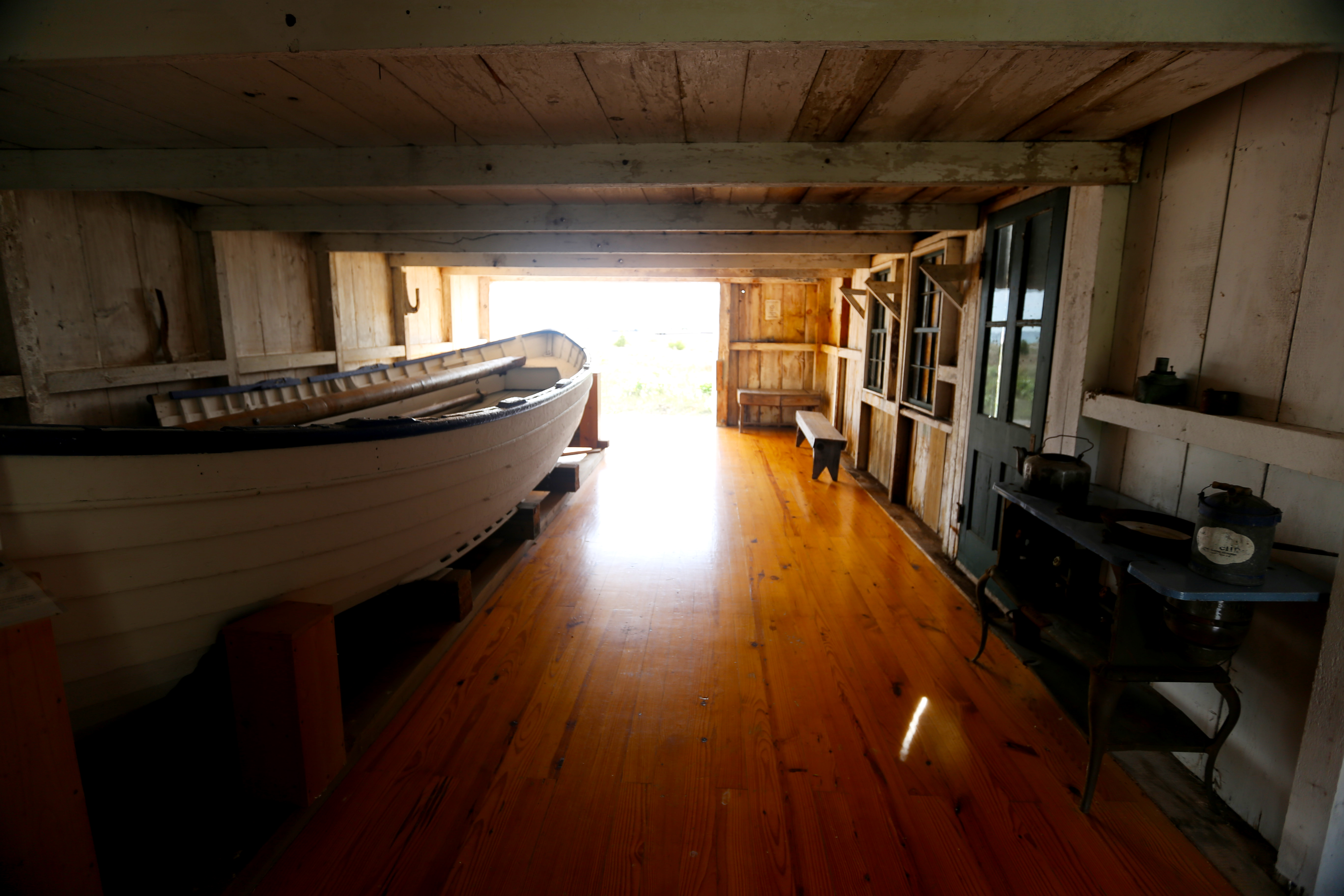
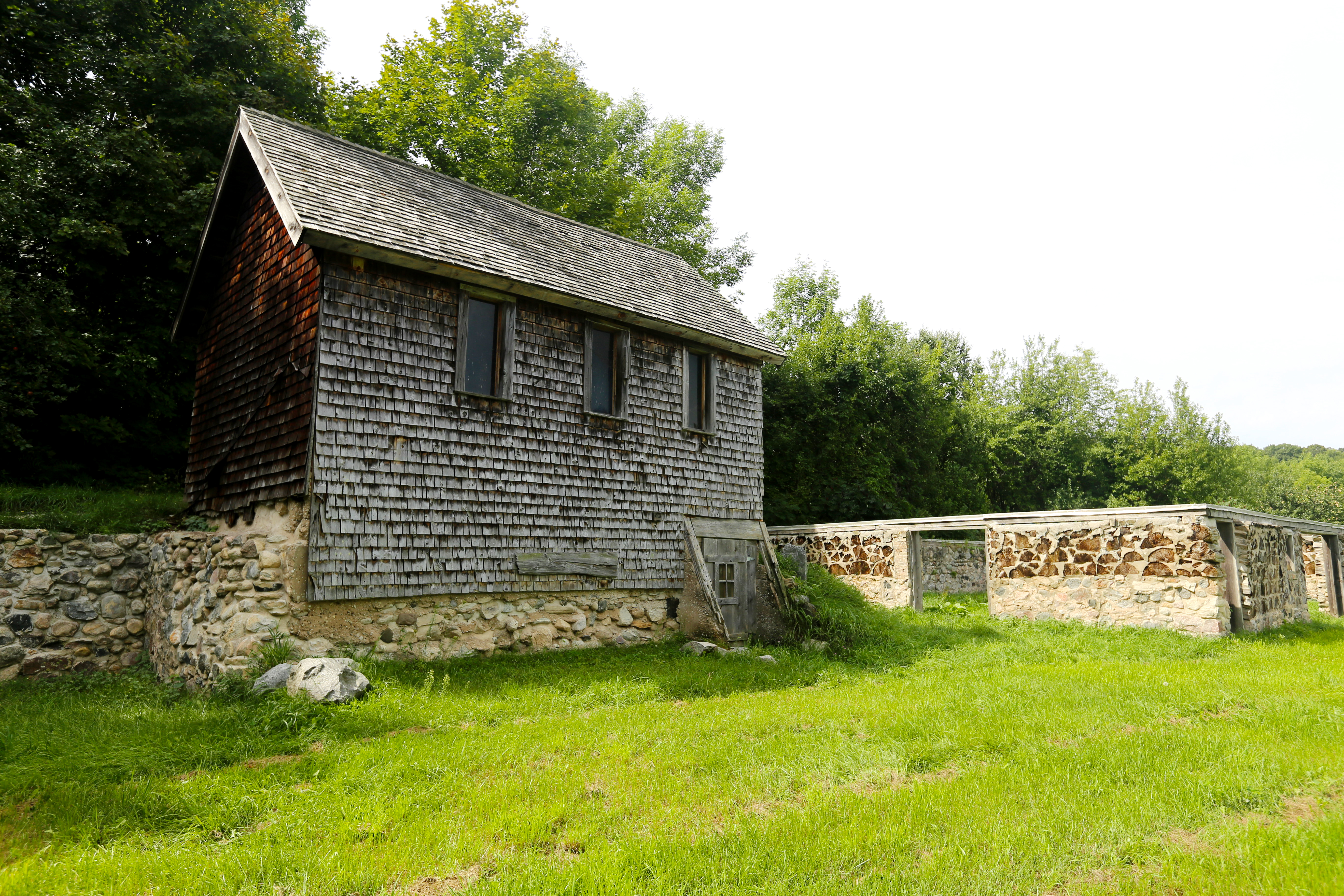
Constructed by the North Manitou Island crew in 1877, this structure is an open, one-story boat house with a clipped gable roof featuring decorative brackets and barge boards. The building was later renovated and used by the Manitou Island Association.
clad with vertical white-painted batten siding and sheltered with a cedar- shingle gable roof. The roof is supported on its 2 outer edges by white-painted brackets tucked beneath the eaves. Also supported by 2 brackets is a shallow ceiling overhang that extends outward just below the gable end facing the water. This gable is faced with the same tile as the roof. Situated on this same end of the building and extending across the structure's entire width is a 3-tiered wooden platform measuring about 8 feet deep and 2 ½ feet high. Take care as you climb the 3 steps up from the surrounding grass to reach the top of the platform as there are no railings. The door to the building, which is sheltered by its own flat roof overhang, is located on the left side of this platform. To the right of the door is a wide rectangular picture window. You may encounter a wooden bench and footrest placed on the platform in front of the window. Located about 75 feet southeast of the nearby boathouse is a flat-topped capstan measuring approximately 3 feet tall. The capstan, which resembles an egg cup perched atop a rounded base, is a vertical-axled rotating machine developed for use on sailing ships to apply force to ropes, cables, and hawsers.
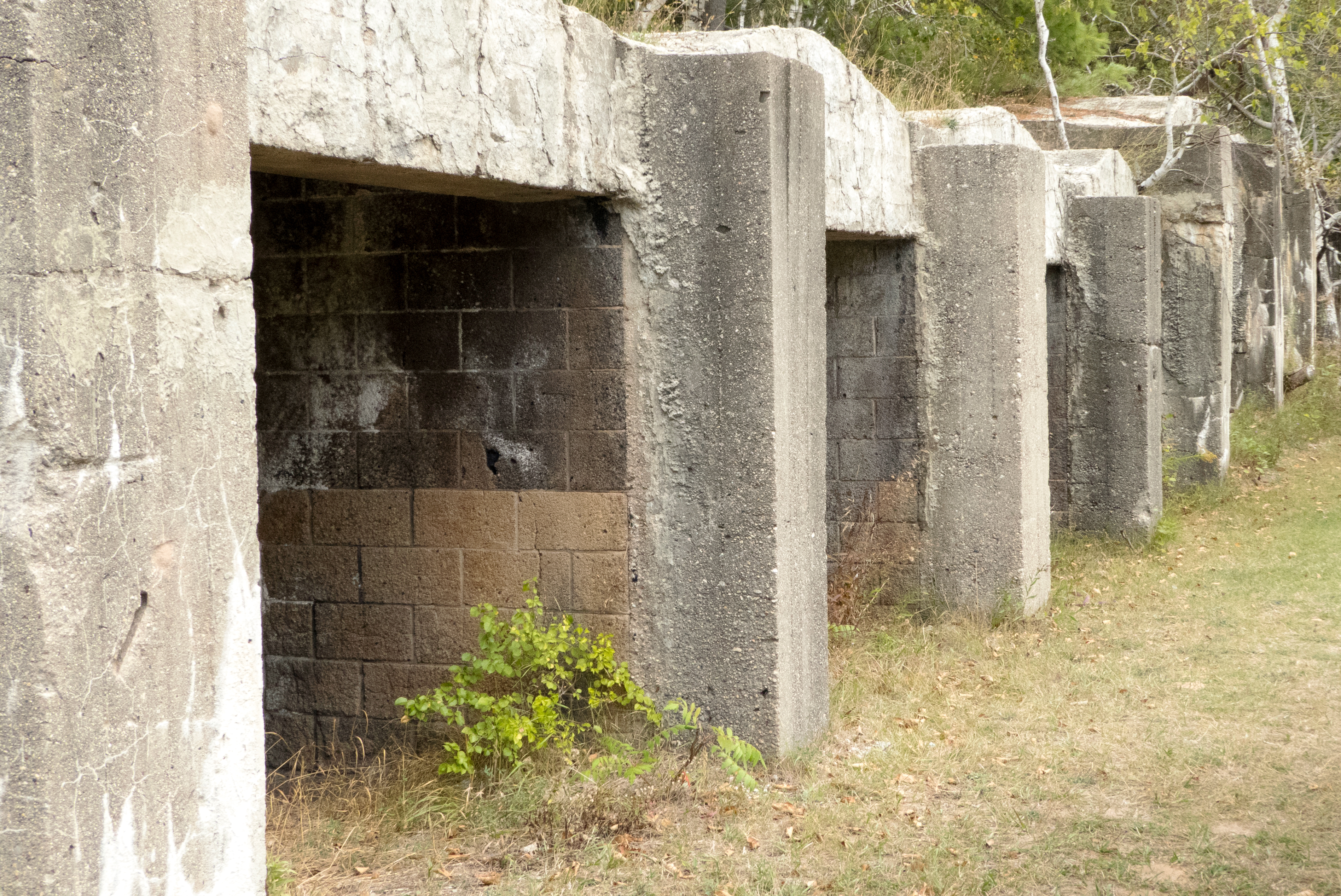
Located at the Alligator Hill Trailhead closest to Stocking Drive, these concrete structures are charcoal kilns. They were installed by lumberman Pierce Stocking who purchased the land in 1948 after the demise of Day Forest Estates. He used these kilns to convert the waste from his sawmill into charcoal. The loose, dusty, random-sized material was packed in bags for shipment to stores in much of Michigan for sale to campers and picnickers
The first point of interest on this trail is a row of curious structures to the left of the trail. These concrete structures are charcoal kilns, and they were installed by lumberman Pierce Stocking who purchased the land in 1948 after the demise of Day Forest Estates. He used these kilns to convert the waste from his sawmill into charcoal. The loose, dusty, random-sized material was packed in bags for shipment to stores in much of Michigan for sale to campers and picnickers. The kilns are concrete ovens in which limbs, slabs, and other sawmill waste were stacked as tightly as possible. The open front was closed with concrete blocks and the wood set on fire just before the last blocks went in. Controlling the air intake was tricky: too much air and the wood was consumed, too little air and the fire went out. If successful, the fire burned slowly for several days. Once it was out, the charcoal was removed and spread to cool. Then it was moved to the bagging shack. Day Forest Hill was one of the first managed forests in this part of Michigan. The owner, D. H. Day, protected the smaller trees to promote a future lumber harvest. When Pierce Stocking purchased the land in 1948, there was enough fairly mature growth to warrant a selective harvest. The sawdust pile from his mill can still be seen on the other side of Stocking Road. After the mature trees had been harvested, the mill was closed and the kilns abandoned.
An often overlooked gem, Alligator Hill is nine miles of hiking trails looping through a hilly, leafy, alligator-shaped ridge with beautiful views of both Lake Michigan and Big Glen Lake. The three interconnected loops allow you to choose the hiking experience you want ranging from a shorter, easier hike leading to great views to a solid workout up and down the rolling hills and through the forest. They are also the only trails in the Lakeshore where horses are allowed.
An often overlooked gem, Alligator Hill is nine miles of hiking trails looping through a hilly, leafy, alligator-shaped ridge with beautiful views of both Lake Michigan and Big Glen Lake. The three interconnected loops allow you to choose the hiking experience you want ranging from a shorter, easier hike leading to great views to a solid workout up and down the rolling hills and through the forest. They are also the only trails in the Sleeping Bear National Lakeshore where horseback riding is allowed. The best cross-country skiing in the Lakeshore, Alligator Hill's trail system offers skiers three loops rated easy, intermediate, and advanced and feature plenty of long downhill runs and equally long climbs. The Forest Haven trailhead parking lot is also the Alligator Hill trailhead of the Sleeping Bear Heritage Trail. Pets are not allowed on the trail in winter. Alligator Hill is a designated cross-country ski trail during the periods of December 1 through March 31.
An often overlooked gem, Alligator Hill is nine miles of hiking trails looping through a hilly, leafy, alligator-shaped ridge with beautiful views of both Lake Michigan and Big Glen Lake. The three interconnected loops allow you to choose the hiking experience you want ranging from a shorter, easier hike leading to great views to a solid workout up and down the rolling hills and through the forest. They are also the only trails in the Lakeshore where horses are allowed.
An often overlooked gem, Alligator Hill is nine miles of hiking trails looping through a hilly, leafy, alligator-shaped ridge with beautiful views of both Lake Michigan and Big Glen Lake. The three interconnected loops allow you to choose the hiking experience you want ranging from a shorter, easier hike leading to great views to a solid workout up and down the rolling hills and through the forest. They are also the only trails in the Sleeping Bear National Lakeshore where horseback riding is allowed. The 1.5-mile hike from the Stocking Road trailhead to the Islands Lookout on top of Alligator Hill is a relatively gentle uphill walk through maple-beech forest on an old road bed. The view from the lookout is spectacular. On a clear day, you can see North and South Manitou Island and Sleeping Bear Point. Quite often South Fox Island will also be visible and perhaps even a freighter making its way through the Manitou Passage. There is a bench at the lookout for you to sit, relax, and enjoy. Continue on to the Big Glen Lookout for a view overlooking miles of vibrant trees to Big Glen Lake. Alligator Hill was named for the long ridge and bluff at its southeast corner that resembles the silhouette of an alligator's snout, best seen from the top of the Dune Climb. Alligator Hill is the result of glacial activity when two lobes of ice that gouged out Big Glen Lake and Little Glen Lake dumped their load of sand and rock between them. An ancient Lake Michigan, that was much higher than today's Great Lake, went on to erode bluffs and cut terraces and notches on the flank of the hill, including the alligator's snout. The best cross-country skiing in the Lakeshore, Alligator Hill's trail system offers skiers three loops rated easy, intermediate, and advanced and feature plenty of long downhill runs and equally long climbs. Pets are not allowed on the trail in winter. Alligator Hill is a designated cross-country ski trail during the periods of December 1 through March 31.
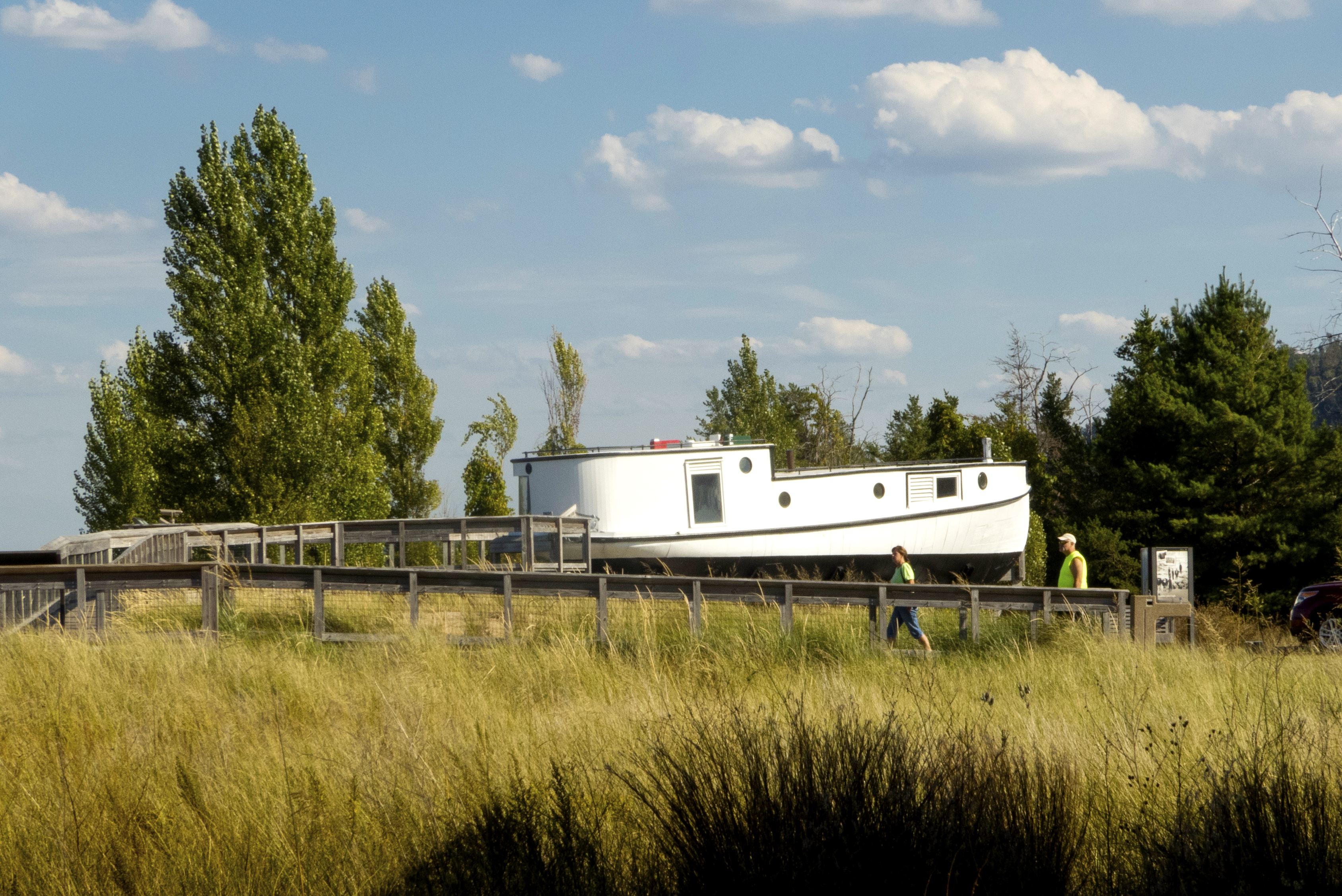
The seventy year-old fishing tug, Aloha, is a style of fishing boat used for gill net fishing. Fish tugs had closed decks and pilothouses amidships or near the stern were common.
The Aloha is a small fishing tug measuring about 12 feet wide and 40 feet long from stern to bow. The tug, which is slightly longer than the average school bus, located near the Glen Haven parking area. The vertical metal sheeting covering the Aloha is painted white. The stern is rounded in shape and fitted with a large rectangular window with a sliding shutter. The tug's flat 2-level roof-lower over the bow and taller over the vessel's higher rear cabin-is lined with a low metal grab railing, about 6 inches high. Two dozen small black dots running along the base of the net represent weights. Appearing along the top of the net are 2 dozen small white dashes labeled "floats." Floating on the water's surface above the net's two top corners are two red buoys topped with red flags. Also appearing on the water's surface above the center of the net are 2 small red circles which are not labeled. Text below the wayside's title explains: The Aloha, part of the boat collection housed in the nearby Cannery, was built for fishing on the Great Lakes. She spent her days navigating deep waters of Lake Michigan gillnetting chubs-small, oily native fish especially prized as smoked fish. Gill nets hang like curtains in the water between floating buoys along their top and anchored lines at their bottom. Chubs swim into the small openings in the net and get caught, often by their gills. Larger fish can't enter the openings and simply swim around the net. The Aloha's crew worked in the enclosed cabin. One used a motorized net lifter to pull up the long gangs of nets (hopefully filled with fish!) through the small hatch near the front on the starboard side. Another removed fish from nets pulled along the sorting table. They then reset the nets through the sliding hatch on the portside stern. As the boat returned to harbor, crews often cleaned and packed the fish on ice in boxes. Back at the dock, they would unload the 100-pound fish boxes before their work was done. See other working and recreational boats from the Great Lakes in the Cannery boat museum. Superimposed one above the other in the wayside's upper right quadrant are two small images. The image at the top is a page printed with Aloha's measurements and other specifications. The tug's weight is noted as 26 gross tons, and materials are listed as "wood hull with galvanized steel sheeting." Additional text tells us that the Fish Tug Aloha was built in 1937 by Sturgeon Bay Boat Works in Sturgeon Bay, Wisconsin. The image appearing below is a black-and-white photo depicting the Aloha docked in the lake. A caption accompanying the photo below d tells us: The Aloha was launched in 1937 and had five different owners during her 50 years of service. She worked out of the Lake Michigan ports of Ellison Bay, Washington Island, Algoma, and Milwaukee, and from Port Wing on Lake Superior. The observation deck holding the Aloha is surrounded by a wooden railing fitted below with a wire mesh grid. This barrier has a total height of approximately 3 feet. Standing a few inches from the railing running alongside the beach at Sleeping Bear Bay is an approximately 5-foot-tall metal pole supporting a pair of binoculars aimed out over the water. A separate metal arm protruding from the left side of the pole at about half its height holds a second pair of binoculars positioned just above the deck railing. As you approach the binoculars from the center of the deck, take care to avoid 2 wooden benches placed side by side, but with a 3-foot-wide space between them, about 4 feet in front of, and parallel with, the deck railing.
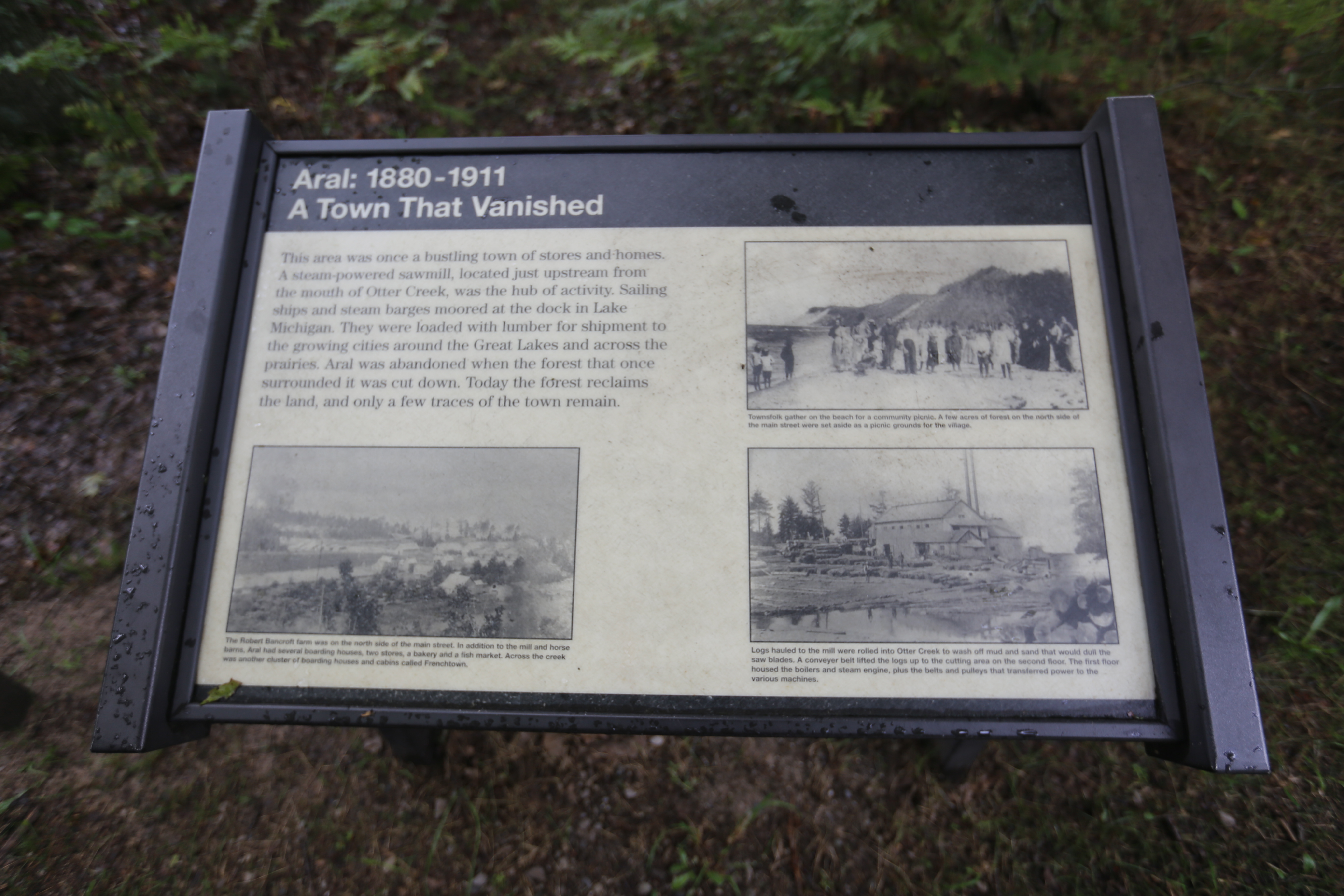
This area was once a bustling town of stores and homes. A steam-powered sawmill, located just upstream from the mouth of Otter Creek, was the hub of activity. Aral was abandoned when the forest that once surrounded it was cut down. Today the forest reclaims the land.
You are standing in front of a wayside panel entitled "Aral: 1880 to 1911, A Town That Vanished." Text below the wayside's title tells us: This area was once a bustling town of stores and homes. A steam-powered sawmill, located just upstream from the mouth of Otter Creek, was the hub of activity. Sailing ships and steam barges moored at the dock in Lake Michigan. They were loaded with lumber for shipment to the growing cities around the Great Lakes and across the prairies. Aral was abandoned when the forest that once surrounded it was cut down. Today the forest reclaims the land, and only a few traces of the town remain. Featured on this panel are 3 historical black-and-white photos accompanied by captions. The first photo, which appears below the wayside's main text in the panel's lower left corner, depicts a number of buildings lining a street and dotting the nearby landscape. A caption reads: The Robert Bancroft farm was on the north side of the main street. In addition to the mill and horse barns, Aral had several boarding houses, two stores, a bakery and a fish market. Across the creek was another cluster of boarding houses and cabins called Frenchtown. To the right of this image, in the panel's lower right corner, is a second photo showing a large wooden building flanked by piles of logs. Additional logs lie in a shallow body of water pictured in the photo's foreground. A caption tells us: Logs hauled to the mill were rolled into Otter Creek to wash off mud and sand that would dull the saw blades. A conveyer belt lifted the logs up to the cutting area on the second floor. The first floor housed the boilers and steam engine, plus the belts and pulleys that transferred power to the various machines. The 3rd photo, located in the panel's upper right corner, shows a group of men, women, and children standing on a beach. Rising behind them are forested hills running alongside the shoreline. The caption reads: Townsfolk gather on the beach for a community picnic. A few acres of forest on the north side of the main street were set aside as a picnic grounds for the village. Located atop an approximately 5-inch-high wooden platform situated a few feet to the right of the wayside panel are 2 trash receptacles and, to their right, a single recycling receptacle. All 3 metal receptacles, which slant forward toward the front of the platform, have square lids that open upward. Handles are located on the lids' bottom edges, or the edges closest to you as you stand in front of the platform. Also located near the Aral wayside is a vertical wayside featuring a large map of Esch Beach. Standing to the left of, and a few feet behind, this map wayside is a small building holding a single vault toilet. Affixed to the building's one door, which is located beyond a small concrete stoop in front of the structure, is a sign indicating that this is a unisex toilet facility. You must take one shallow step up from the stoop to enter. The door opens outward from left to right. Please take care as you approach the toilet building as it stands atop a slight incline. The cement stoop is flush with the bare ground on its front edge only, and there are no railings.
Of the island's 5,260 acres, over 65% is beach, sand dunes, or steep slopes unsuitable for agriculture, but the central part of the island, newly logged, was ripe for agriculture. The Becks arrived in the 1860s from Germany. Along with the Hutzlers and Haases, they contributed toward making the island a thriving agricultural community.
The August Beck Farm is one of 3 surviving farmsteads on South Manitou Island. Both the August Beck farm and the George Conrad, or G. C., Hutzler Farm are located along an approximately 2-mile-long hiking loop situated in the center of the island. The total hiking distance from the village and around the loop and back is about 6 miles. The George Johann, or G. J., Hutzler Farm is located north of the island's cemetery along another section of trail. Buildings at the Beck Farm include a white clapboard farmhouse and two additional buildings clad in rough-faced shingles. All that remains of the Beck barn is its tall foundation. A small wooden sign bolted to a short pole standing alongside the farmhouse reads: "A. Beck. Circa 1860." Take care as you explore the grassy yard surrounding the buildings as you may encounter uneven ground. There are also some fruit trees located nearby. The 2-story farmhouse has 2 intersecting main building sections and a one-story wing that extends from the back of the house, all covered with black-shingled gable roofs. On the front of the house, tucked between the 2 main sections, is a small porch with a sloping hip roof supported by 2 thin columns. Two steps without railings lead up to the porch, which is also without railings and elevated about 2 feet above the ground at its highest point. There is also a cellar hatchway located a few feet beyond the porch on the house's left side. Filling the gables above the structure's 2nd-story windows is decorative millwork consisting of several horizontal rows of flat scallop-shaped shingles. The windows themselves, which are trimmed in dark-painted wood, are covered with white shutters. All of the shutters have small circular openings-either one or 2 per shutter-located in the center of the shutter's top half, bottom half, or both halves. A handful of shutters also are fitted, either near the bottom edge or near the top, with slightly larger square openings. These square openings appear to be covered with glass, whereas the circular openings appear to be filled in from the inside. The largest of the 2 shingle-sided buildings is a 2-story structure with a tall stone foundation, a side-facing gable roof, and 3 glass windows situated just under the long roofline that faces you. Two rough-hewn wood timbers, slanting outward from top to bottom, flank the entrance door, which is located on the right end of this facade. This building served as the farm's granary. The building's rear side is built into a grassy hill dotted with rocks. To the left of the structure is a stone wall acting as a retaining wall below the hill; to the right of the entrance is a large pointy-topped stone jutting out from the grass. Located to the right of the granary is the Beck Barn foundation, measuring about 40 feet wide by 30 feet long and 6 or more feet high. This foundation reveals that the barn was built using the stovewood construction technique, consisting of short logs, or cordwood, set in mortar. Lining the front and sides of the foundation are several window and door openings crowned with horizontal lengths of lumber spanning the structure's entire width and depth. Note that the lower section of the foundation is constructed of fieldstone.
Small beach access for Bass Lake accessible off of M-22.
This is one of two Bass Lakes in the park. It is an easily accessible lake visible on the east side of M-22 about 6 miles north of Glen Arbor. There are several access points off of M-22 plus a short two-track at the North end where you can park along the sandy shore and swim, fish, or launch a kayak. There are two small cabins at one end of the lake, but most of the lake is wild. The surrounding land is open, the shore is firm, and the bottom is sandy. All these features make Bass Lake one of the prettiest places for a lazy day picnic. There are no restrooms here, but some are available at nearby School Lake.
Bass Lake in the Platte Plains area is probably the best-known all-purpose lake in the park for hiking, canoeing, and fishing. Surrounded by aspen, white pine, and cedar, the calm lake is protected from the winds off Lake Michigan and is a great starter lake for teaching kids about fishing, hiking, or boating.
A wooden dock and wheelchair-accessible boat ramp provide access to Bass Lake, a calm body of water surrounded by a maple-beech and pine forest. This lake, which lies directly south of Otter Lake, offers opportunities for canoeing, kayaking, fishing, and swimming. The dock and boat ramp are located at the end of Trail's End Road, where the water is edged with tall grasses and other low vegetation. With the exception of an approximately 3-foot-wide section on its front edge, the Bass Lake Dock is lined with a wooden barrier, or curb, measuring about 6 inches high, as well as several wooden pilings, or pillars, about 2 ½ feet high, that flank the dock's sides. Bolted to the dock in the center of the open section is an approximately 3-foot-high metal handrail, similar to those used in swimming pools. About 6 feet behind you as you stand at the handrail at the front of the dock is a long wooden bench that faces the water. The path approaching the dock is gravel. Standing atop a wooden pole to the left of the dock's entrance is a white sign with red lettering that reads: "Caution. Hazardous Conditions." Additional pillars separate the gravel path from the boat ramp, which slopes downward toward the lake alongside the dock's right side as you face the water. The ramp's concrete surface is partially covered with gravel and overgrown with grass as it nears the water. You must carry your canoe or kayak from the lake's large parking area, where you will also find a vault toilet. Motorized boats are not allowed on the lake. In addition to the water activities available at Bass Lake, the surrounding forest offers hiking on the Platte Plains trail system.
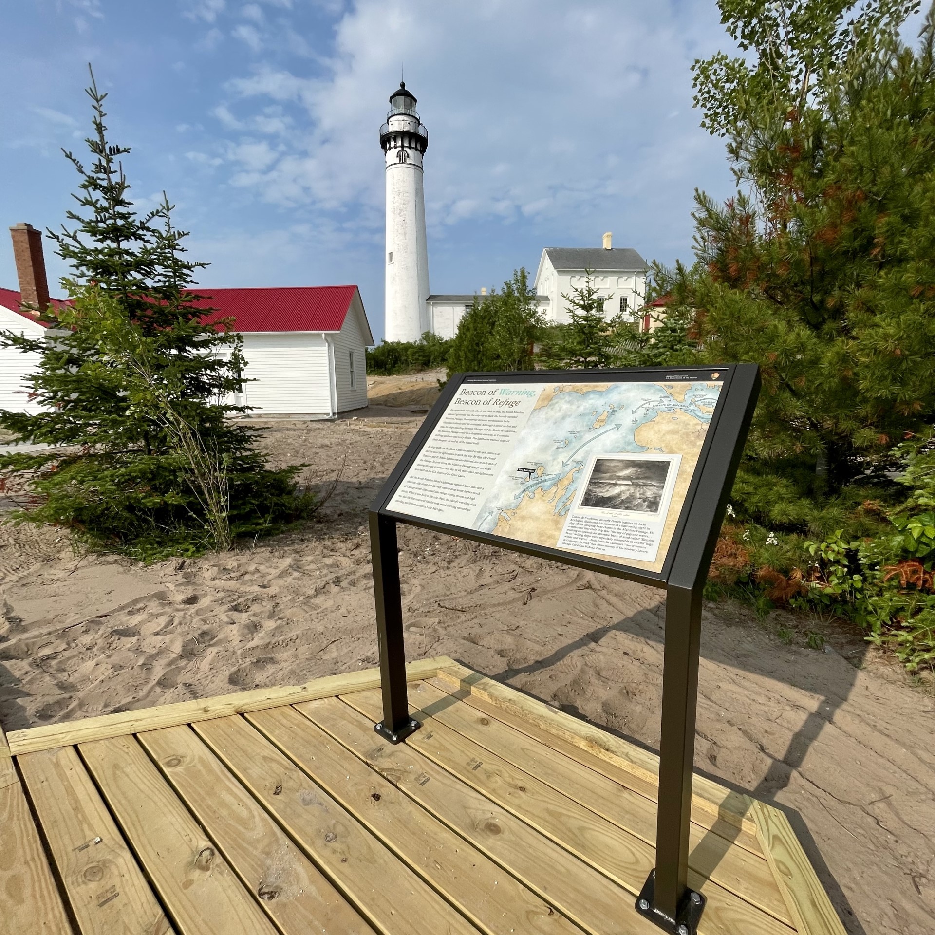
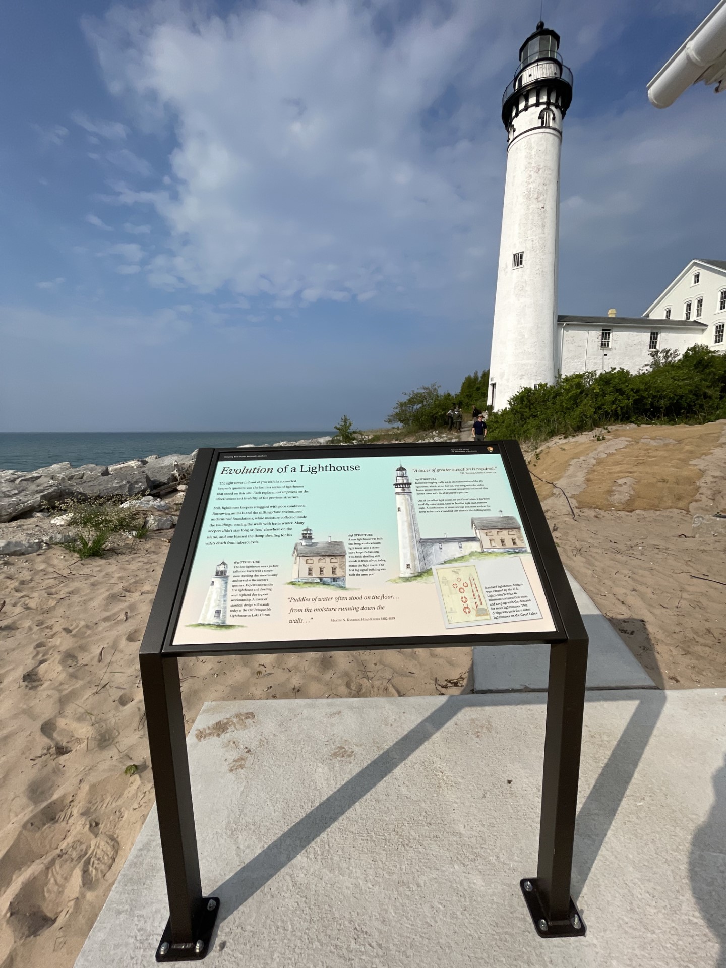
“Beacon of Warning, Beacon of Refuge” is a slanted outdoor panel that is thirty-six inches wide by twenty-four inches high and attached to a frame with brown metal legs. On the left side, black letters on a beige background: “Beacon of Warning, Beacon of Refuge” For more than a decade after it was built in 1839, the South Manitou Island Lighthouse was the only one to mark the heavily traveled Manitou Passage, the waterway between northeastern Lake Michigan’s islands and the mainland. Although it saved on fuel and time for ships traveling between Chicago and the Straits of Mackinac, the Manitou Passage could be a dangerous shortcut, as it contains shifting sandbars and rocky shoals. The lighthouse warned ships of these dangers-as well as the island itself! As ship traffic on the Great Lakes increased in the nineteenth century, so did the need for lighthouses to mark the way. By 1859, the Grand Traverse and Point Betsie lighthouses also beamed, one at each end of the Passage. In peak times, the Manitou Passage saw fifty to one hundred ships passing through its waters each day. In all, more than two hundred and fifty lighthouses were built on the U.S. shores of the Great Lakes. But the South Manitou Island Lighthouse signaled more than just a shortcut-the island had the only natural deep-water harbor north of Chicago where ships could take refuge during storms and high winds. When it was built in the mid-1830’s, the island’s wooding dock was also the first source of fuel for large wood burning steamships traveling north from southern Lake Michigan. On the right an outline of the blue waters of Lake Michigan with a tan land mass surrounding it. In the south, blue arrows point to the Point Betsie Light. Going north, an arrow labeled Manitou Passage is located between the mainland and South Manitou and North Manitou Islands. Continuing past the Manitou Passage the Grand Traverse Light is located on a peninsula. Moving further north, the lake widens and the islands are further away from the mainland. The next blue arrow moves past South Fox Island with a lighthouse, North Fox Island, and Beaver Island with a lighthouse in the south and north ends of the island. The next arrow moves past a scattering of lighthouses in the lake and on land as the Straits of Mackinac are approached and the corner is rounded to Mackinac Island and Bois Blanc Island at the top of the map. Arrows move around those islands and point back to the Straits of Mackinac. At the bottom right corner enclosed in a beige box covering the map is a black and white illustration of many high waves. The white sand cliffs of Sleeping Bear Dunes are in the background and above them a dark cloudy sky. Below: Comte de Castlenau, an early French traveler on Lake Michigan, illustrated his account of a harrowing night in 1839 off the Sleeping Bear Dunes in the Manitou Passage. He commented that their ship was “the toy of gigantic waves…pushing us towards an immense bank of sand called “Sleeping Bear.” Sailing ships were especially vulnerable in storms’ high winds and waves.-from Comte De Castlenau’s “Vues et Suvenirs de L’Amerique du Nord.” 1842. Photo courtesy of the Newberry Library, Chicago. You may now go to the left to the panel, “Saving Lives and Cargo” or explore the panels and map inside the Fog Signal Building or move towards the Light Tower up a slight incline.
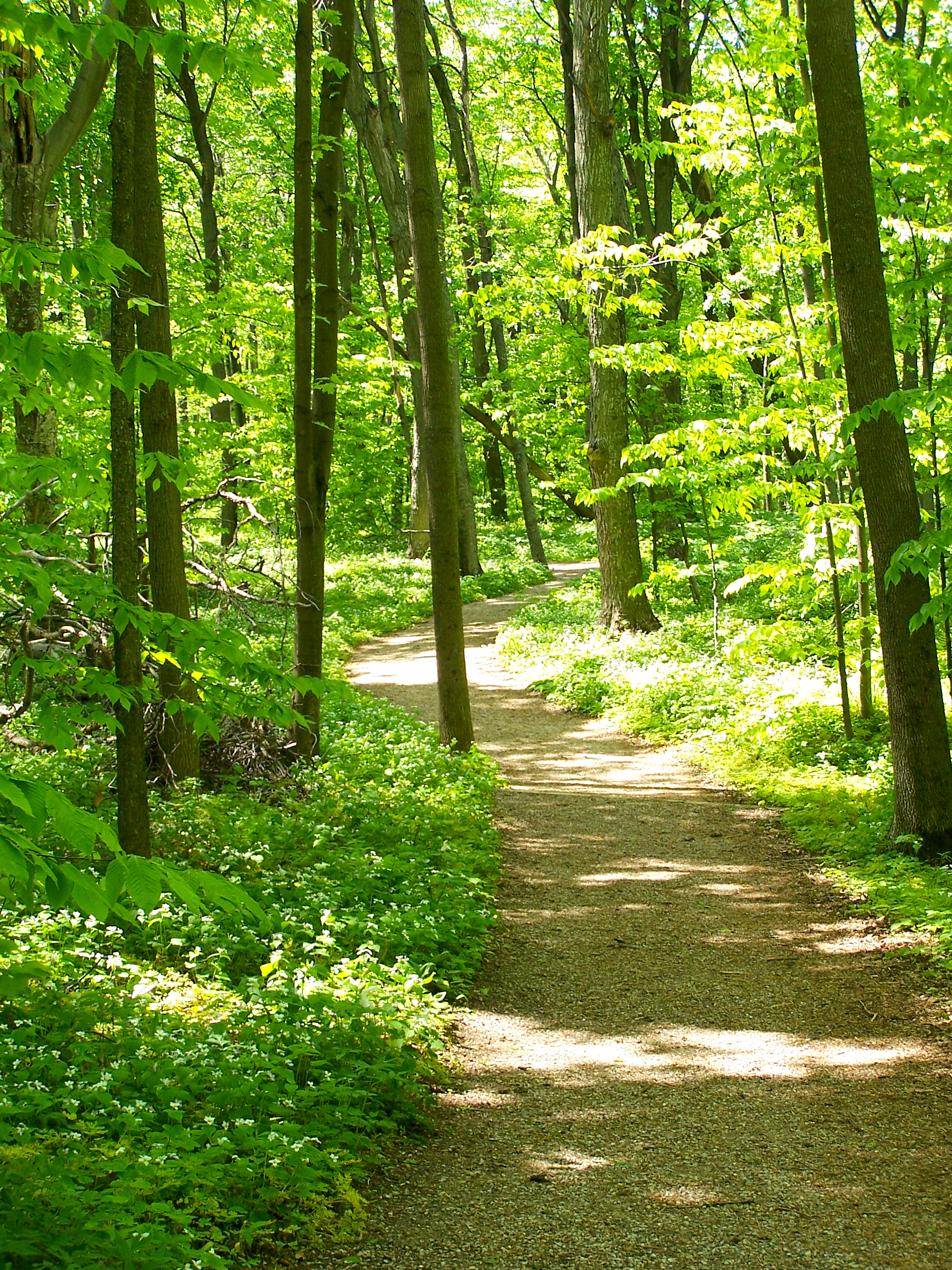
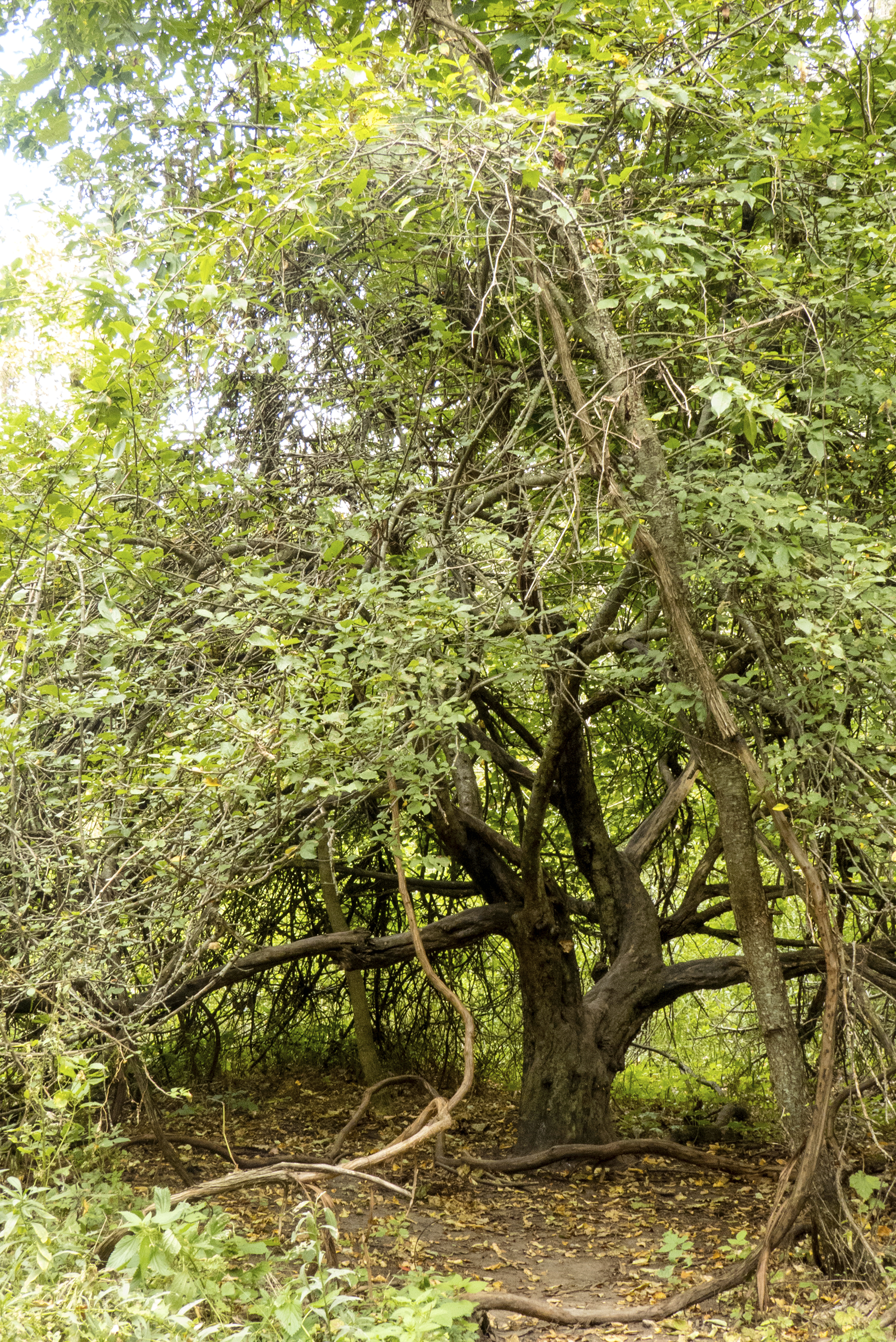
What a startling contrast we find between the open, sunny environment of the dunes and the lush, shady world of the beech-maple forest. Here plants must compete for the limited amount of sunlight. Shade-tolerance is the key to survival.
What a startling contrast we find between the open, sunny environment of the dunes and the lush, shady world of the beech-maple forest. Here plants must compete for the limited amount of sunlight. Shade-tolerance is the key to survival. The dominant trees are sugar maple and American Beech. Both are able to survive in the shade of taller trees. However, if by chance a young tree gets enough sunlight, it experiences a burst of growth. By growing tall, it can reach the opening in the canopy of leaves. In addition to beech and maple, you will see black cherry, hemlock and basswood trees here. This is he climax forest of the area. Other plant communities, given enough time, tend to phase into a beech-maple forest. Once established, this forest remains stable unless it experiences a setback such as forest fire or logging. Tune in all your senses. Maybe you will catch a glimpse of a squirrel or deer, or smell the odor of decaying leaves, or hear the flutelike song of the wood thrush.
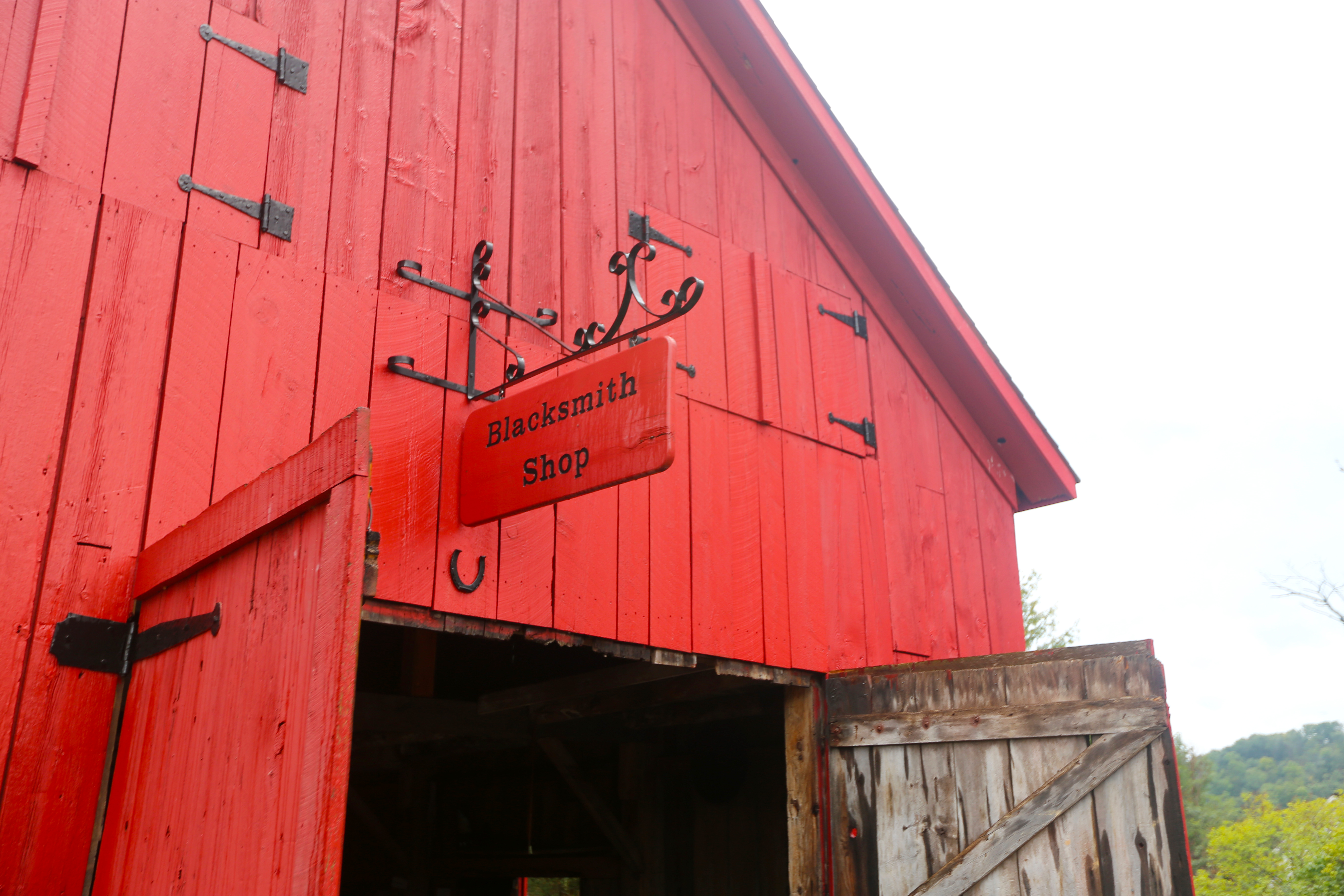
Built around 1867, the Blacksmith Shop was an indispensable component of the maritime village. Not only did the shop forge metal works, but it also served as the town's carpentry center. Nearly everyone in town had some need for the blacksmith's services, which included crafting and repairing oxen yolks, tools, and carriages, shoeing horses, and constructing pre-built homes, dining halls, and horse barns.
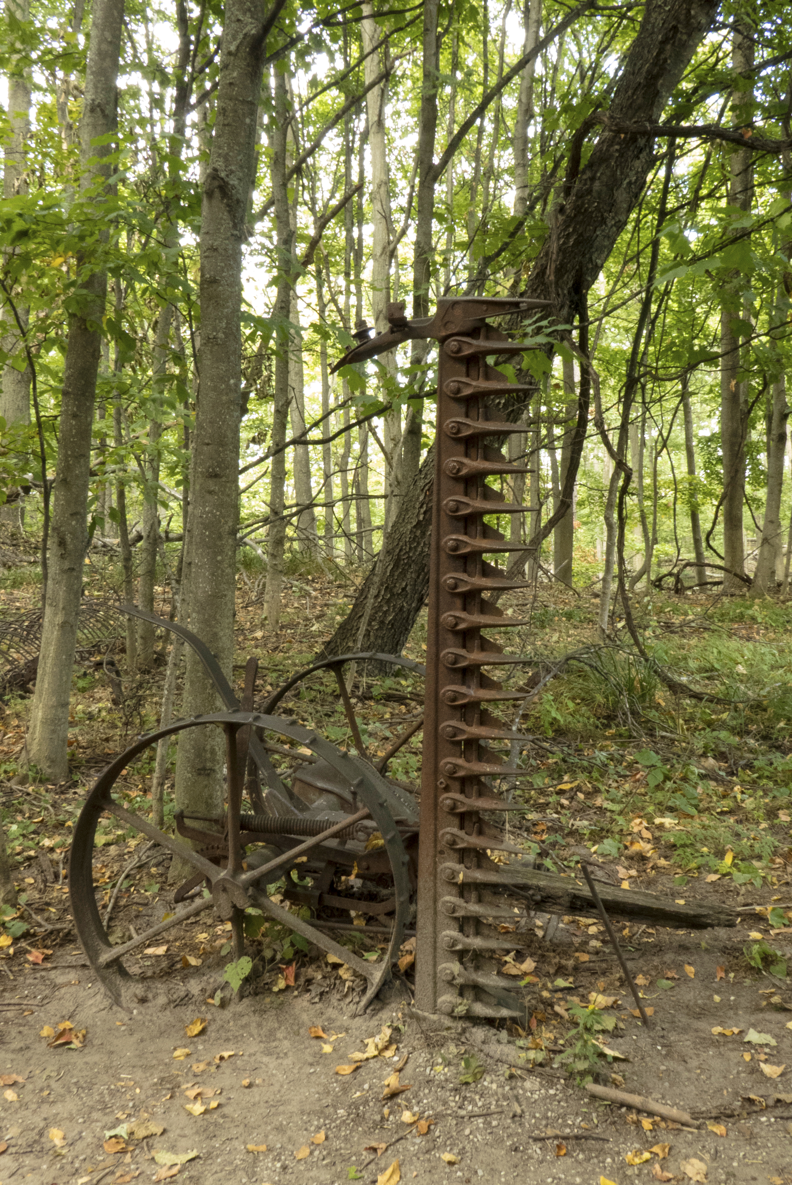
A wooden walkway leads to the Glen Haven Village blacksmith shop, a 2-level structure with red-painted vertical wooden plank siding and a black-shingled gable roof. The large wooden double doors flanking the approximately 10-foot-wide entrance doorway open outward and will likely be fixed in this position during your visit. Suspended from a black iron bracket protruding from the gable located directly above the entrance is a red-painted wooden sign with the words "Blacksmith Shop" painted in black. The approximately 8-foot-long entrance walkway and a longer walkway that runs lengthwise in front of the shop are flat and level with the ground. The transition into the building is also flat, without steps. There are no railings. Positioned in the grassy yard to the left of the building and behind a waist-high rope barrier are several pieces of large equipment, including broken farm machinery and a massive metal cylinder set atop wood blocks. This is identified as a ship's boiler.
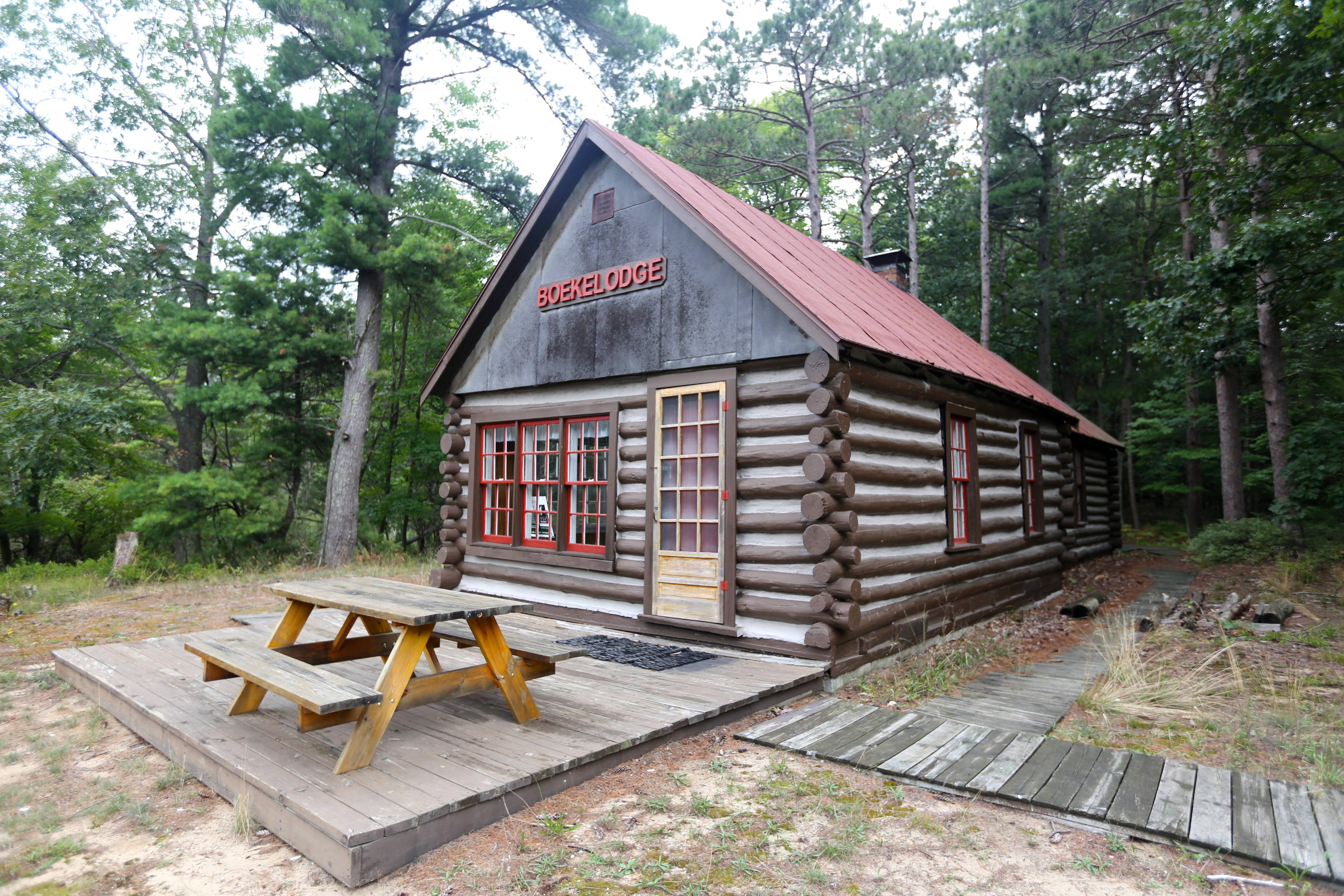
The Boekeloo lodge has been a landmark in Benzie County for over 70 years. Sitting along a cranberry bog, the quiet beauty of the pond and surrounding forest, and the reflection of the cabin on the still water invites visitors to sit right down and enjoy the setting. The building started as a homestead cabin eventually becoming a wilderness vacation spot. Walk around the lodge and peak in the windows to get a glimpse of vacation life in this little cabin in the woods.
Built as a homestead cabin by the Cooper family in the late 1800s, the Boekeloo Lodge is located on the south side of the Lakeshore at the end of Boekeloo Road, about 8.5 miles south of Esch Road on M-22. This one-story log structure with a red gable roof looks out onto a large pond that once served as a cranberry bog, dug out by Miles Boekeloo in the late 1940s. The name "Boekelodge" appears in large raised red letters on the structure's wooden-plank front gable. Located to the left of the lodge's entrance door, which is situated on the facade's right side, are 3 double-hung windows placed side by side. The wooden trim surrounding the windows and the mullions surrounding each window's 12 panes are painted red. The cabin's outer door, which is constructed of what appears to be light-colored natural wood, has 15 glass panes. Extending across the entire width of the lodge's facade is a wooden deck measuring about 25 feet wide, 20 feet deep, and 8 inches high. This deck, which holds a wooden picnic table with attached benches placed lengthwise, or parallel to the building, is slightly lower on the end closest to the building. Near this lower end and on the right side of the deck as you face in from the front of the building, is a wooden walkway, placed nearly flush with the ground. There are no railings on either the walkway or the deck. As you step onto the deck, you may encounter a mat in front of the entrance. The picnic table stands directly to your left. Although the lodge is not open to the public, visitors are invited to walk around the building, which is flanked by forest on all but its front side. Situated about 10 feet in front of the deck's outer edge is a low pile of split logs and dark earth that serves as a retaining wall between the sandy ground surrounding the property and the grassy area edging the pond. Only a few trees dot the grass in front of the lodge, yet the pond's opposite bank is lined with a wall of old trees.
Port Oneida's first non-native settlers, Carsten and Elizabeth Burfiend and their daughter Magdalena, settled this farm. The family originally lived in a log cabin. The Carsten Burfiend farm is on both sides of the Port Oneida Road. The house, garage, and other out-buildings are on the west side of the road on the bluff overlooking Lake Michigan. The foundation of the barn, silo, and milkhouse as well as the corn crib and machine shed are on the east side of the road.
north of M-22. Situated to the west of the road are several structures, including a 2-story white clapboard farmhouse, a one-story garage, and, positioned in the grass several yards behind and to the right of the house, a small outbuilding, presumably an outhouse. The farmhouse faces the bluff overlooking Lake Michigan, and visitors are offered a glimpse of the lake through the trees standing just beyond the house's front lawn. The Port Oneida Road runs behind these buildings. Located on the east side of the road is the foundation of the farm's original barn, silo, and milk house, as well as the corn crib, machine shed, and several pieces of abandoned farm machinery. As viewed from the front, the farmhouse has a black-shingled gable roof and a square wood-floored porch with its own gable roof supported by 3 square pillars on its front edge. The porch is elevated about a foot or more above the grassy ground surrounding the house, but there are no steps. A brick chimney rises alongside a smaller side-facing gable located further back on the roof, near the middle of the building. There are 4 windows on the facade: one rectangular multi-paned window located to the left of the entrance door, which is on the porch's right side, 2 other windows located in the second story above the porch roof, and a smaller square window with a single pane centered at the top of the gable just below the roofline. White-painted wood boards cover a double window located to the left of the porch on the first floor. The garage is located slightly behind and to the right of the house with one long side facing toward us. The farmhouse dates to around 1930.
Imagine how this land must have looked just after the glacier melted about 11,800 years ago. It was a landscape of sand and gravel stretching in every direction. No trees would have blocked your view.
Imagine how this land must have looked just after the glacier melted about 11,800 years ago. It was a landscape of sand and gravel stretching in every direction. No trees would have blocked your view. Only a few hardy plants struggled to survive. From this bleak beginning, plants, by their living and dying, have slowly created a layer of topsoil covering these sandy hills. Living communities of plants and animals have transformed this once-sterile ground into the productive forest that now surrounds you.
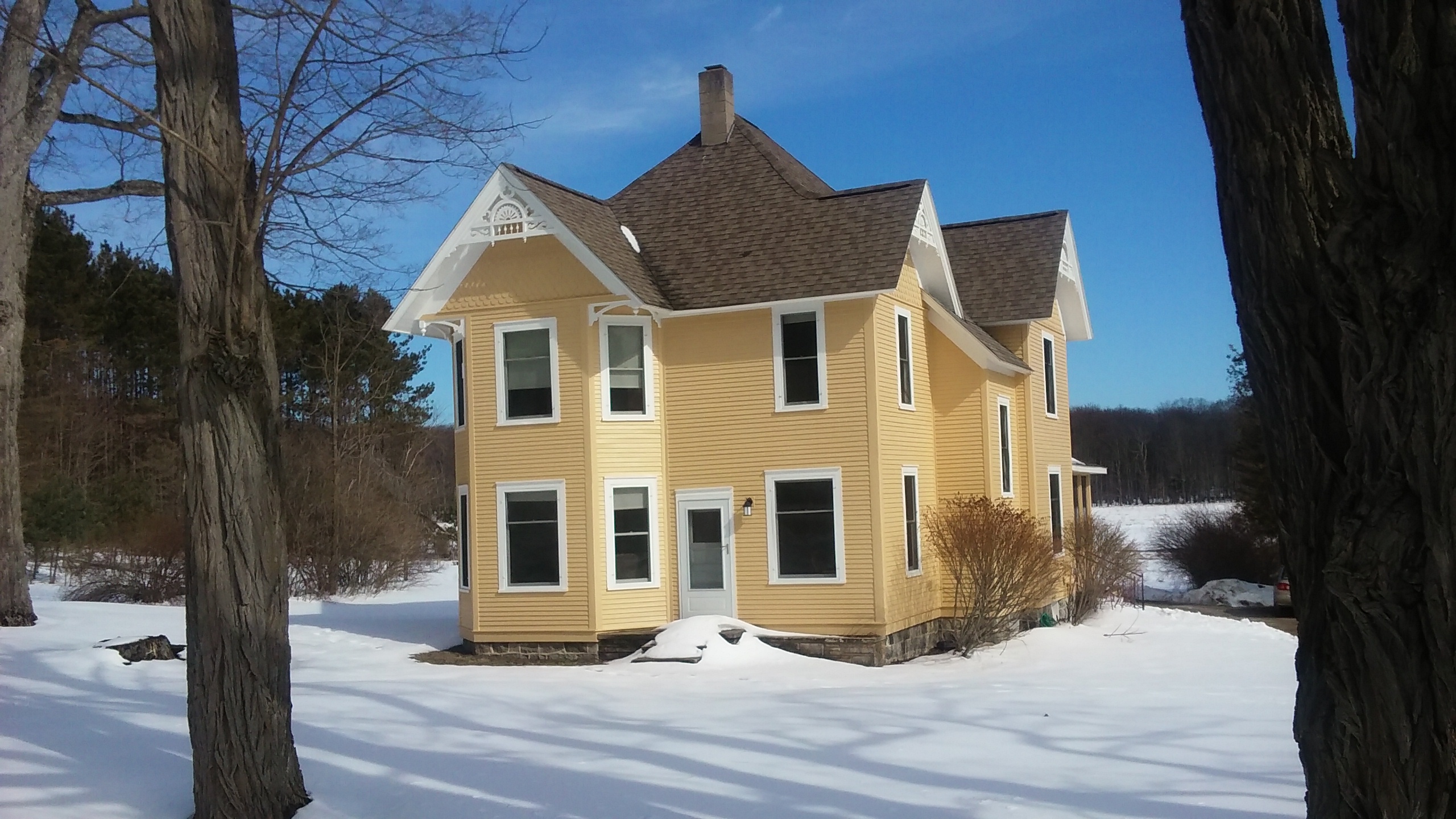
Charles and Hattie Olsen bought this land in 1915 from Frederick Dechow, who had first purchased it in 1857. The Olsen's farmhouse was built around 1918 and is the most modern. The house had the first indoor plumbing; water was pumped by hand into a tank in the attic to provide the pressure for the system. A dairy farm, it was the first to achieve Grade A dairy status in Port Oneida.
A short dirt driveway leads into the Charles and Hattie Olsen Farm, which is located on the M-22 Leelanau Scenic Heritage Route. This is the newest farm in Port Oneida with 2 buildings dating to 1918: a modified bungalow-style farmhouse and a large 2-story barn. These buildings are situated to the right and left of the driveway respectively. The farmhouse contains a history center offering several exhibits providing information about the Port Oneida area. The 2-story farmhouse is clad with white clapboard, and there is a single brick chimney jutting from the center of its black-shingled gable roof. Extending across the entire width of the structure's facade is an open concrete porch, its low-pitched shed roof supported by a white-painted beam and 4 block pillars, tapered at the top. The beam's curved bottom edge forms 5 arches: 3 separating the 4 pillars on the front of the porch, and 2 between each of the end pillars and the house facade itself. Positioned on the porch roof between the 2 central pillars framing the entrance is a gable pediment featuring on its face a red and white sunburst design. This design is repeated on both gable ends on the house's 2 sides and also on the sides of a dormer with shed roof that juts out from the main gable roof above the porch. There are 2 such sunburst designs on each gable end, framing a small diamond-shaped window located just below the gable's peak. There are 2 wide concrete steps in front of the porch at its center, flanked by a line of low manicured shrubs on either side. Take care as you take one additional step up to reach the porch itself, as you may encounter 2 potted plants, one each placed in the opening formed by the 2 central pillars. There are no railings on the front steps nor on the porch. Standing on the porch's left edge and reaching to the roof is a tall open-grid trellis. The porch's right side is open, overlooking a small garden and a white picket fence extending away from the building. You may encounter 2 benches, one each placed below the 2 windows flanking the entrance door, which will be located straight in front of you as you step onto the porch. There may also be a thin mat placed in front of the door. There is a wide wooden ramp without railings located on the back of the house. As you near the top of the ramp, a wooden entrance door will be on your right. Mounted to the building to the left of the door is a cast iron bell with an attached rope dangling to about 3 ½ feet above the ramp. Grab the ball at the end of the rope to ring the bell, and someone will open the door for you. Otherwise, this door remains locked. Section 2 (161 words)The farmhouse interior boasts hardwood floors and dark wooden trim around the windows and doors. Here you will find a series of displays, maps, and videos offering an in-depth look at the Olsen family and others in the Port Oneida community, as well as information about the 366 historic structures and landscape features found in this area. Also included is information about the Port Oneida residents who rescued passengers and crew of the Rising Sun, which wrecked on the shore here in October, 1917. As you step inside the farmhouse, a small information desk with guestbook will be located immediately to your right. An arbor with arched top in the middle of the picket fence allows access to a single picnic table with benches located in the back yard. As you approach the table, take care to avoid a large propane tank and a wooden clothesline standing near the table. The farmhouse is open in the summer months through Labor Day. Section 3 (176 words) The three-bay barn is the only remaining gambrel-roofed barn-and also one of the largest barns-in the Port Oneida Rural Historic District. Its exterior is constructed of red-painted vertical wooden planks, and both its sloping gambrel roof and a shed roof sheltering a one-story section on the end closest to the driveway are constructed of gray metal sheeting. A silo located on the barn's back end is made of wood staves and is supported by steel rods which band the silo at every few feet up the silo's height. This barn is partially built into a hill on its right side.<br />Take care as you walk around the barn as there is a stone retaining wall extending out from the barn's right side. This wall is topped with a narrow walkway leading upward to a door on that same side of the building. It is not suggested that you climb this walkway as there are no railings on its front side, which is situated at least 4 feet above the ground at its highest point.
Considered a special treat within the lakeshore, the Treat Farm is one of the most underrated attractions. A hike through the woods along the old road leads to the fascinating old farmhouse and related buildings.
The Charles H. Treat Farm is situated at the end of a ½-mile-long trail that leads slightly uphill from the corner of Norconk Road through a portion of the maple-beech forest. The buildings still remaining at this farm include a 2-story gable-roofed farmhouse dating to around 1880, a barn, a concrete garage, a root cellar, a machine shed, and a chicken coop. The final approach to the farm is a wide grassy path running through a clearing flanked by low vegetation. The Treat farmhouse, which is clad in white clapboard, has a porch situated on its left side as you approach from the grassy path. A set of 4 concrete steps flanked by low concrete barrier walls on both sides leads up to the rightmost end of the porch, which is edged by a concrete kick wall on 2 sides. Supporting the porch's shed roof are 4 square white-painted pillars positioned atop the kick wall near the roof's front edge. The porch holds a picnic table with attached benches; you will encounter one end of this table a few feet to your left as you step onto the porch. Protruding from the house to the right of the porch, and tucked below a secondary gable on the main structure, is a 4-sided building appendage resembling a bay window with a foundation. At least 2 of the 4 windows on this appendage are boarded up while the others are covered by louvered shutters. Located about 4 feet from the rear of the house, and jutting up about 6 inches from the ground, is the round concrete cap of the farmhouse cistern. Placed atop this cap, which measures about 3 feet in diameter, is a wooden frame consisting of a flat board with a short leg on each end. Hanging from the nearby roof is a section of a metal gutter once used to drain rainwater into the cistern. Take care as you approach the cistern as the wooden frame, which is positioned perpendicular to the house, juts out several inches beyond the cap's edge. Two additional structures at the farm include a garage with a concrete dome roof and a rounded concrete root cellar built into the hill near the garage. The garage and the root cellar each have 2 wide metal doors with a single padlock in the center.
Want to really experience the dune plateau? The 1.5-mile Cottonwood Trail is a great place to get out of your car, loop through the perched dunes, and see the sublime scenery up close. The Cottonwood trail loops over unique dune landscapes and offers spectacular views over golden sand dunes of the azure sky, aquamarine Glen Lake, white D. H. Day barn, ultramarine blue Lake Michigan, and distant verdant green of the Manitou Islands.
Cottonwood Trail is an approximately 1½-mile loop that takes visitors through the perched sand dunes above the Dune Climb. The trail provides access to a variety of cottonwood trees, dune grasses, shrubs, and wildflowers as well as views of Glen Lake and D.H. Day farm. Also of interest is a bowl-shaped dune located to the right of the trail. This dune is called a blowout, formed by erosion from southwesterly winds. Although much of the trail winds through loose sand, the approach at the trailhead is paved, and the trail's first several feet are covered with a walkway of wide wooden planks. Both the paved area and the walkway are level with the ground flanking them on either side, and there are no railings. Affixed to the top of the first of several wooden poles standing several feet apart to the right of the trail is a small sign with the drawing of a bicycle intersected with a diagonal red line. Text below the drawing reads: "No Bicycles." Please be advised that much of this trail is hilly and there is no shade. It is recommended that you wear sturdy shoes, a hat, and carry drinking water and sunscreen. There is a bench along the way where you may sit and survey the dunes, Glen Lake and the surrounding countryside. As you walk the trail, take care to avoid poison ivy, which is a common dune plant found along this and other trails at Sleeping Bear Dunes National Lakeshore. Collecting plant life is not permitted, and all pets must be kept on a leash
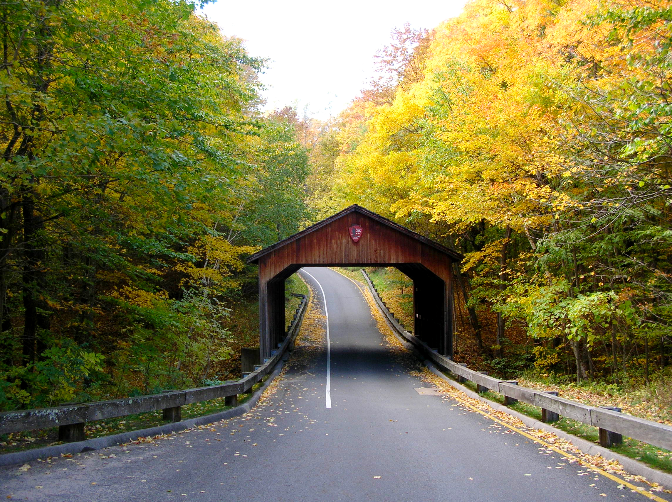
Have you ever seen a covered bridge with the National Park Service arrowhead on it? The original one, built by Mr. Pierce Stocking for his scenic drive, did not boast the symbol, of course. He just wanted to provide a picturesque detail for sightseers to stop and photograph.
A wayside panel stands near the covered bridge. This panel, entitled with the quotation "...a perfect setting for a Perfect Day," features a large map drawing of the scenic drive, which appears to the left, or west, of Glen Lake. Text below the title tells us: Pierce Stocking (1908-1976) wanted to preserve this area's natural beauty. In the early 1960s, the local lumberman began envisioning "a haven of rest" called Sleeping Bear Dunes Park. It opened to the public in 1967. For just $2.75 per vehicle, visitors could drive a fourteen-mile scenic roadway, relax at picnic areas, and delight in spectacular views of Lake Michigan, Glen Lake, and the sand dunes. When Sleeping Bear Dunes National Lakeshore purchased Stocking's park in 1976, they renamed it Philip Hart Nature Trail after the U.S. Senator from Michigan who fought to establish the Lakeshore six years earlier. Staff considered removing the scenic drive to protect the fragile dunes. Ultimately, they realized what Stocking had: if you want people to love this earth enough to conserve it, they also have to be able to enjoy it. So the drive remained, and the Lakeshore renamed it in honor of Stocking and his resolve to preserve this place for future generations. This map contrasts the loop you're driving on today (blue) with Stocking's original route (orange). Pictured below this text in the panel's bottom left corner is a color photo of a stocky man, his shirt sleeves rolled up to the elbows, standing beside a black dog. A caption accompanying the photo reads: Pierce Stocking worked at a Civilian Conservation Corps camp in Cadillac, Michigan during the Great Depression. The skills he acquired there helped him construct this drive. What do you think this area would look like today without Stocking's efforts? Appearing in a horizontal line to the right of this photo are 4 smaller photos with text, all falling under the general title "Evolution of a National Treasure." Text accompanying the photo on the left, entitled "Great Lakes Gardens," tells us:<br />The drive's original entrance, the Great Lakes Gardens, showcased rose bushes, hiking trails, and ponds in the shape of all five Great Lakes. Text below the second photo, entitled " A Very Steep Hill," explains:<br />From the gardens, Stocking's drive curved up the dune face to Picnic Mountain. Cars stalled; transmissions failed. This ascent was soon dubbed "Suicide Hill." The text accompanying the next photo, entitled "Porcupine Damage," reads:<br />The Lakeshore rebuilt Stocking's covered bridge in 1986 in order to accommodate taller vehicles and to repair damage done by munching porcupines. The last block of text, entitled "Road Revisions," explains:<br />To prevent erosion of the dunes, the Lakeshore moved the drive's entrance; closed segments (orange); and rerouted the drive into a one-way loop (blue). Running along the length of the panel's bottom edge is a timeline beginning with 1960 on the far left and ending with 2016 on the far right. It is noted that in 2011, Good Morning America named the Lakeshore "The Most Beautiful Place in America." Section 3 (182 words)<br />Affixed at an angle to the top of a wooden base located near the wayside panel is a small metal plaque with a verdigris, or bluish-green patina. Appearing in raised letters at the top of the plague is the title "Pierce Stocking, 1908 through 1976." Text below the title reads: Pierce Stocking, a native of northern lower Michigan, worked as a lumberman and spent much of his leisure time in the woods. He wanted to share his love of nature with others and conceived the idea of constructing a scenic drive onto the Sleeping Bear Dunes. He envisioned people of all ages and degrees of physical fitness experiencing the sand dunes and the bluffs overlooking Lake Michigan. At the same time, he hoped to protect the fragile dunes and woods from excessive human use by concentrating activity along the road and at scenic overlooks and picnic areas. In 1967, Pierce Stocking fulfilled his dream with the opening of the scenic drive to the public. The drive was operated privately until 1977 when it became a part of Sleeping Bear Dunes National Lakeshore.
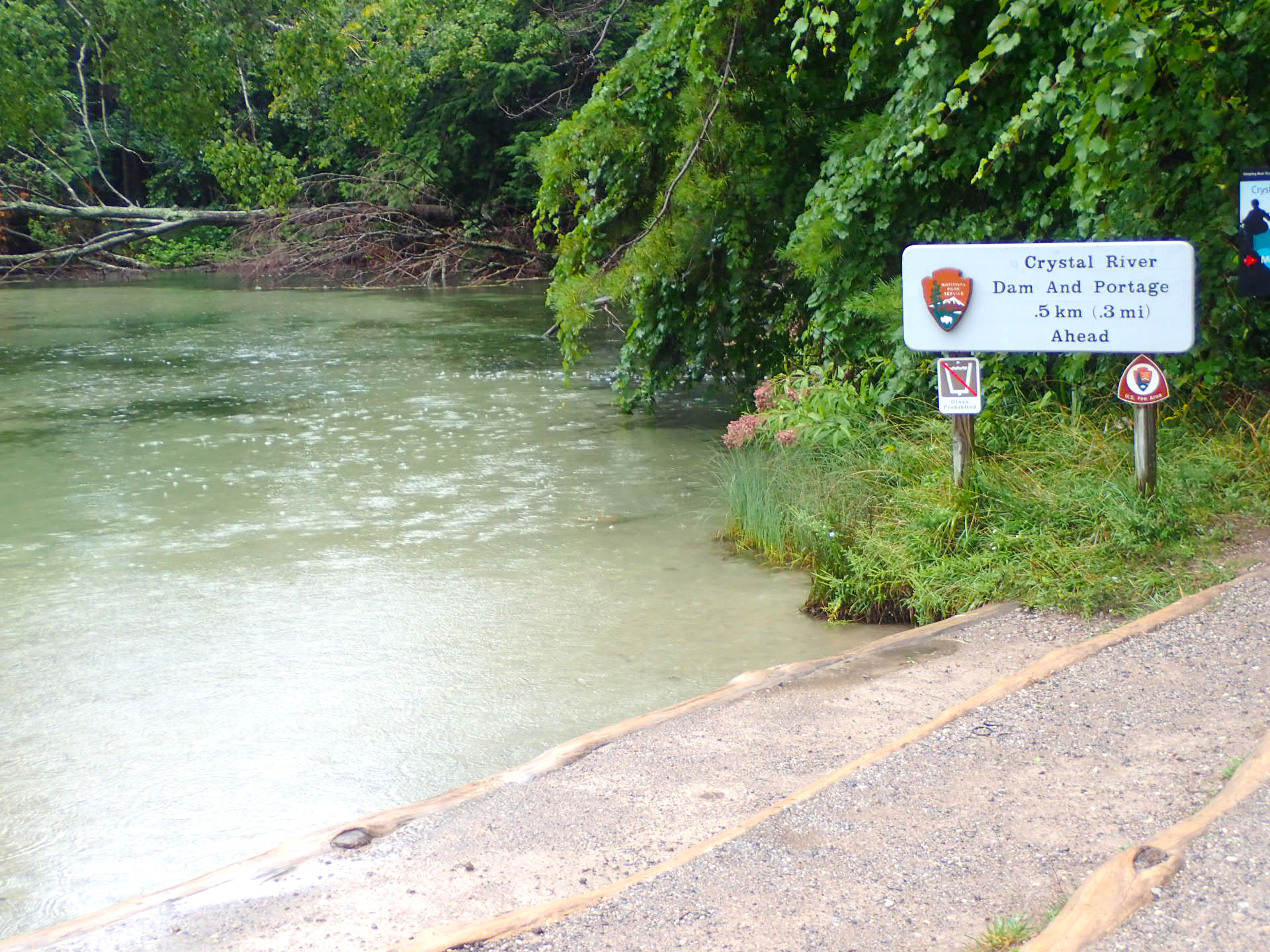
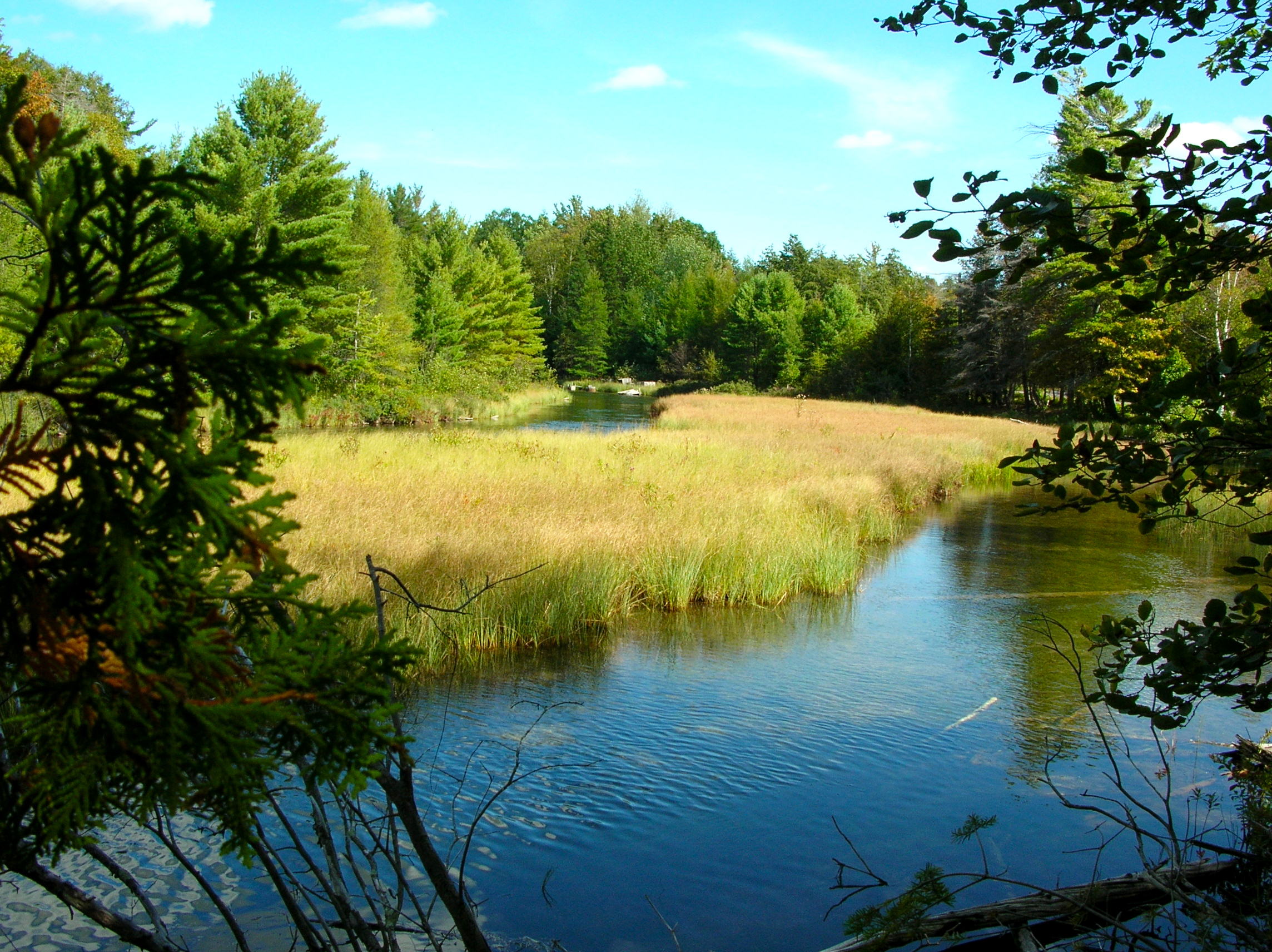
Ah, the beautiful Crystal River-gentle currents, meandering curves, water as clear as glass. The Crystal River winds from Glen Lake through sections of the Lakeshore into Lake Michigan just north of Glen Arbor. Shallow (water depth is rarely more than 1 foot) and with a sandy bottom, this river is ideal for families, beginning canoeists and kayakers. The river and surrounding wetlands provide interesting and valuable habitat to enjoy.
A wide tiered ramp provides boat access to Crystal River, which flows from Glen Lake to Lake Michigan at the north end of the park. The 2 dirt steps making up the ramp section closest to the water each measure about 4 ½ feet deep and are edged with logs at both the top and bottom. Crystal River offers visitors an opportunity to canoe, kayak, or paddle in calm water. You may bring your own boat, raft, or tube, or you can rent canoes and kayaks in Glen Arbor. Note that low water levels in the Crystal River can make canoeing difficult at times. Bolted to a wooden pole standing near the river is a sign entitled "Crystal River: yours to protect." Drawn on the sign's bottom half and extending across the entire width of the sign are 3 wavy bands of color beginning with a dark blue band on top, a light blue band in the middle, and a yellowish-green band on the bottom. These bands are labeled from top to bottom as "high," "medium," and "low." Affixed to the sign to the left of these labels is a red arrow that points to the label indicating the water level at the time of your visit. Text on this sign explains: Over 135 animal species call Crystal River home. Many are tiny creatures that cling to the river bottom or thrive among aquatic plants. As water levels drop, their habitat...and their lives...are at risk. Destroyed habitat poses a serious threat to the fishery, as well as everyone's enjoyment of the river. Please help preserve aquatic habitat by checking the red arrow for current water level. High. Canoes and kayaks float peacefully over aquatic life. These water levels provide the most fun for people and the least risk for aquatic organisms. Medium. Use caution: avoid shallow areas so boats, paddles, and feet do not contact the river bottom. Keep boats as light as possible to prevent bottom disturbance. When in doubt, use a second boat.
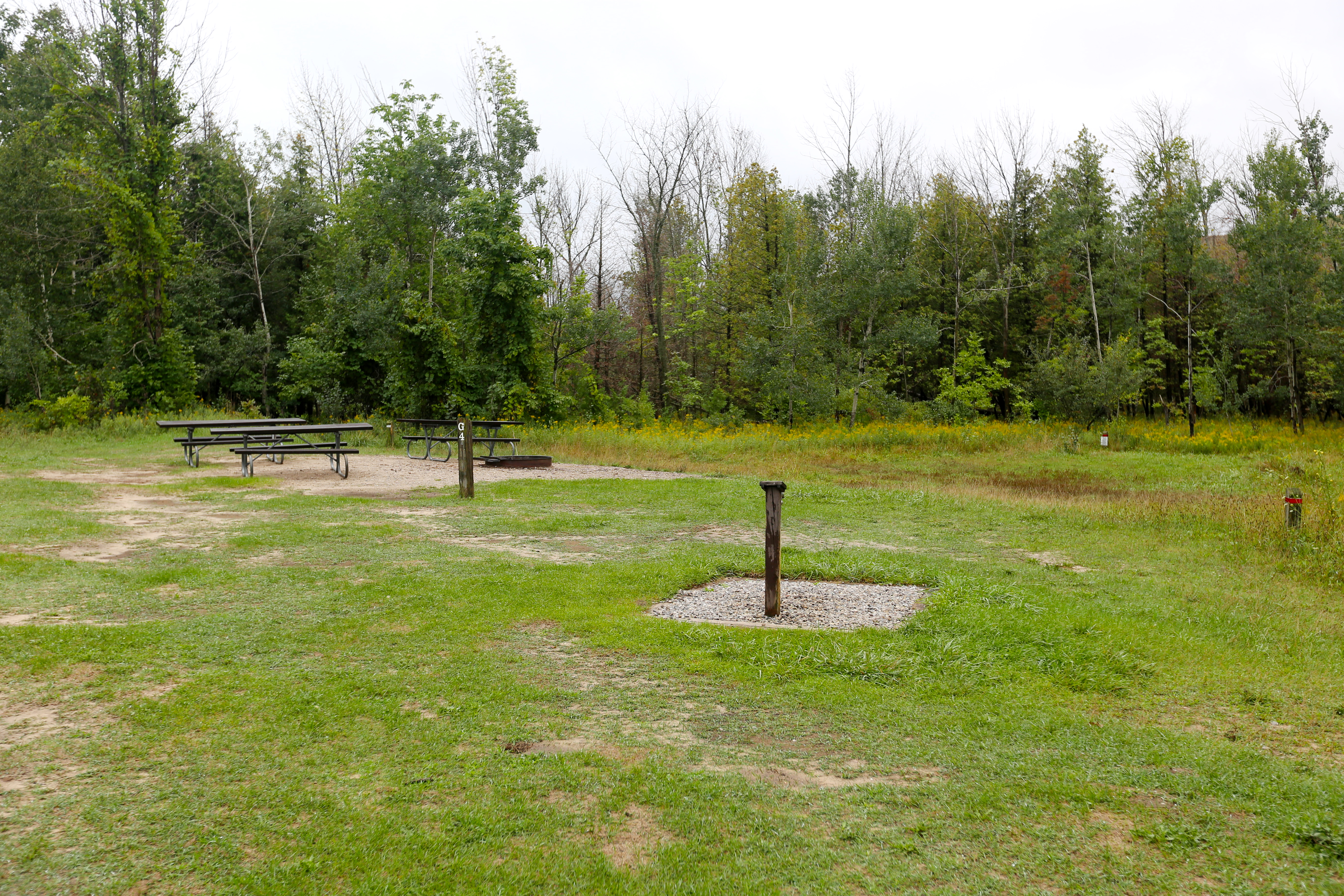
D.H. Day Group Campground is a tent-only facility located in the heart of Sleeping Bear Dunes National Lakeshore. This campground has four sites which accommodate groups of 7 to 25 people. The campground is open with sparse vegetation. Pets are NOT allowed in the campround. Picnic tables and campfire rings are provided at the campsites. The campground has drinking water during the reservation season, May 1 through Oct. 14. Pets and RVs are not allowed in group sites.
The D.H. Day Group Campground is a tent-only facility located off M-109 at the end of Harwood road about one mile north of the Dune Climb. Open year round, this campground has 4 sites which accommodate groups of 7 to 25 people. The campground area consists of an open field dotted with sparse vegetation. Vault toilets and fire rings are provided, but drinking water is only available during the reservation season between May 1st and October 15th. Pets and RVs are not allowed in the group sites. The area surrounding the D.H. Day Group Campground offers opportunities for hiking the dunes and enjoying various water activities. There is a boat ramp located about 6 miles away where boaters can access Lake Michigan. Campers can also rent canoes and kayaks in Glen Harbor to explore the nearby Crystal River. The beach at Glen Haven is about one mile away from the campground.
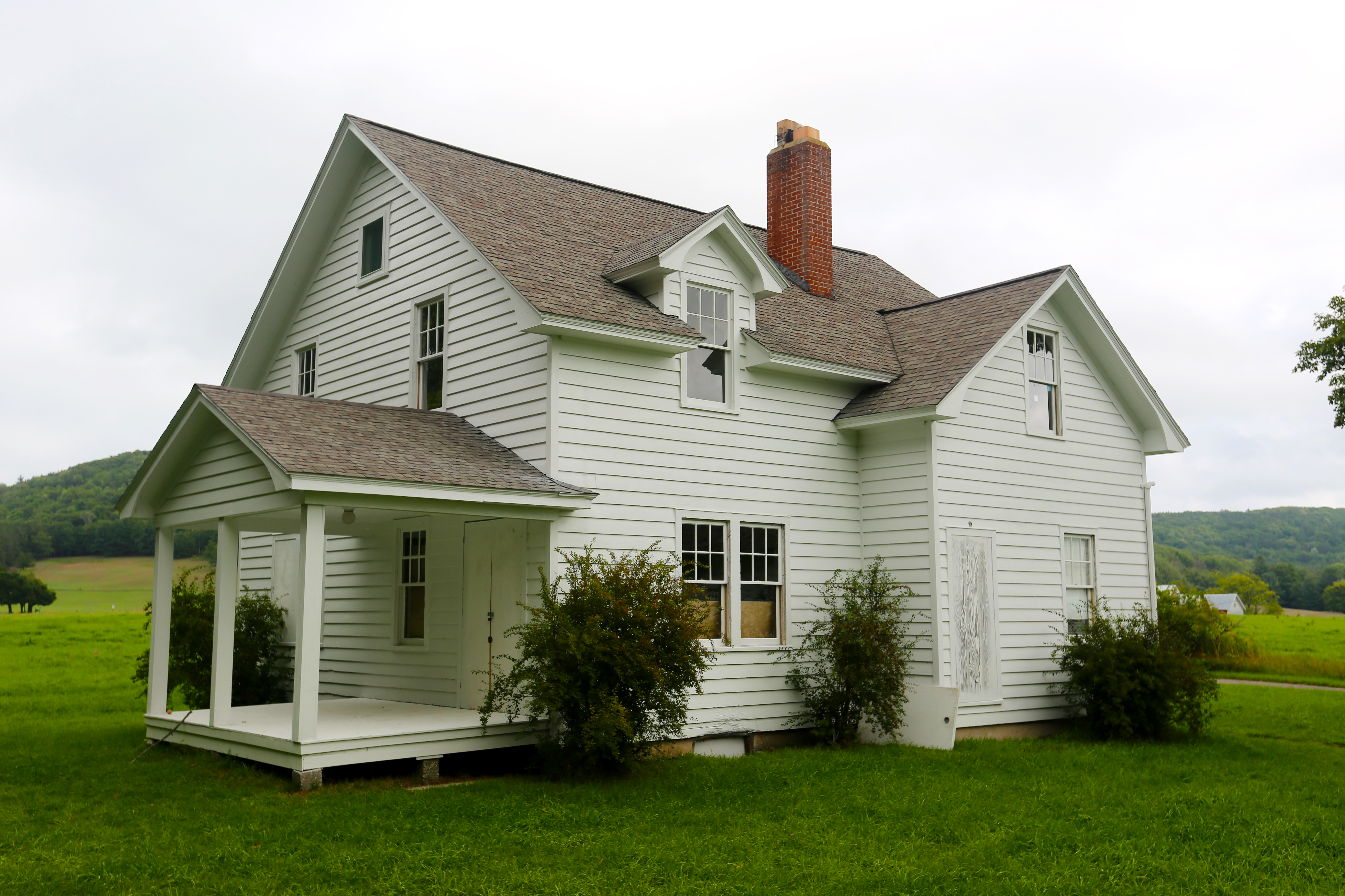
D.H. Day built this simple two-story frame house in Glen Haven in 1890 as a birthday present for his wife Eva, but she preferred the convenience of living above the general store she ran while raising a family, so Day employees and other family members lived in the house. According to Day's granddaughter, Pat (Day) Bennet, her father Bill Day had a garden straight back from the house by the apple tree.
The Day House in Glen Haven Historic Village is a white clapboard frame building with 6 windows on its facade-4 on a 2-story wing with a black-shingled gable roof, and 2 on a one-story wing offset behind a narrow porch extending to the right. The shed roof shading the porch is supported by 2 thin pillars. A small sign posted to the left of the narrow walkway leading to the porch reads: "Private Residence."
Looking for a slightly more rugged camping experience? Check out the D.H. Day Campground. Beautifully wooded, peacefully quiet with well-maintained sites and a shimmering beach on Sleeping Bear Bay, D.H. Day provides an excellent setting for a calming family vacation. Located in the heart of Sleeping Bear Dunes, the campground is perfectly situated for exploring the area.
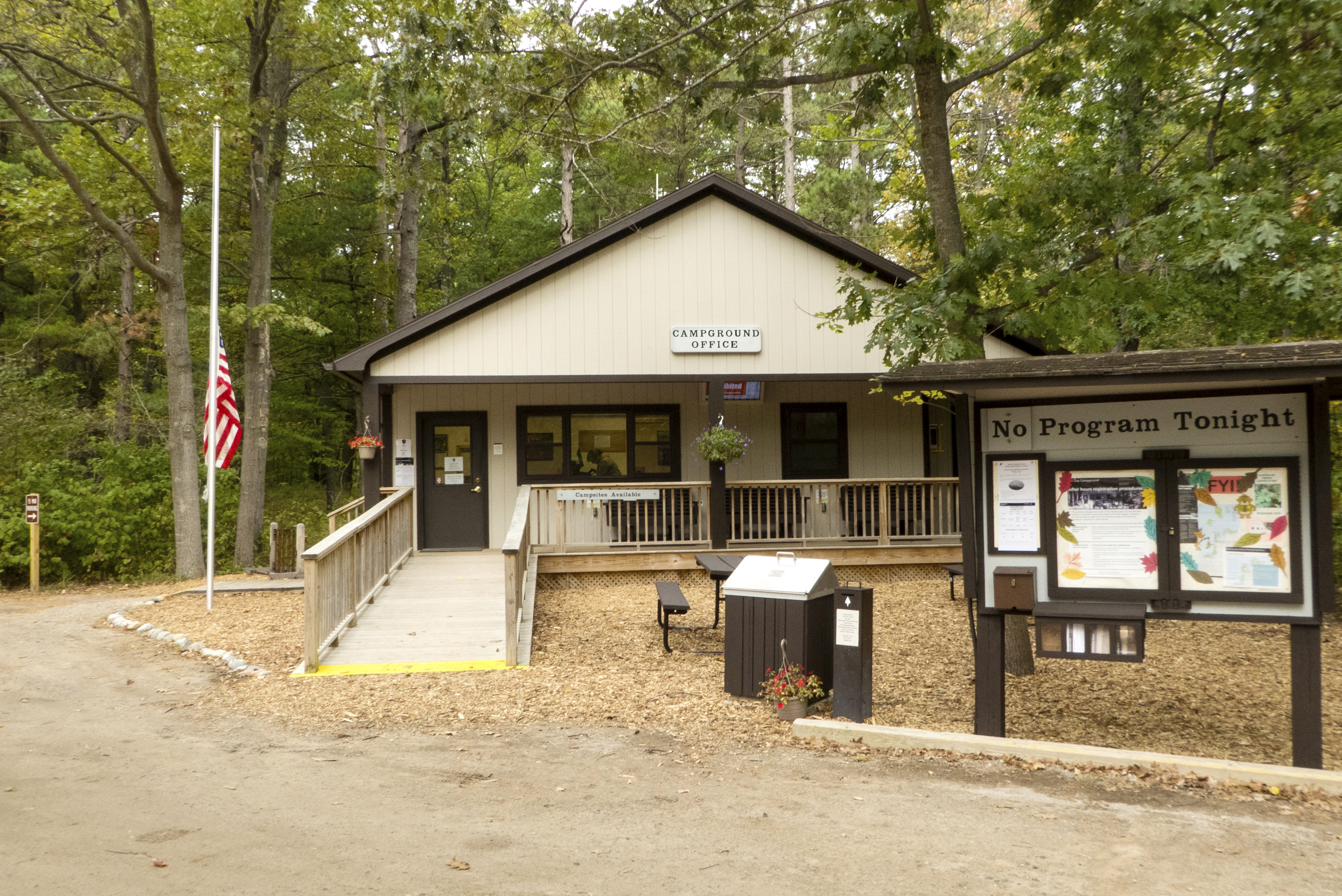
The rustic D.H. Day Campground lies in a wooded area on M-109 about 5 miles north from the point where M-109 intersects with M-22. This facility offers 87 private camp sites as well as easy access to a Lake Michigan beach from the campground's north end. Vault toilets and seasonal water spigots are available throughout the campground. Fires are allowed in the metal fire rings provided at each site. Campers wishing to reserve a campsite can make a reservation up to six months in advance for arrival dates of May 15 through October 15 by calling 1-877-444-6777 or online at www.recreation.gov. Campers must stop at the campground office to check in before arriving to their site. This office, which is located near the campground entrance, is contained within a small one-story structure with a gable roof and a small front porch. You may access the porch in one of 2 ways: by stepping up a short wooden walkway and 2 steps located on the porch's left end or by using a longer wooden ramp that runs perpendicular to the front of the porch. The top of the short wooden walkway is positioned about 4 inches above the surrounding ground. There are no railings alongside this walkway, but the 2 steps leading from this walkway up to the porch are flanked on the left by a wooden handrail and on the right by a square porch pillar. Standing about 3 feet to the right of this walkway is a flagpole flying a United States flag. The longer wooden ramp, which slopes slightly upward to meet the porch just to the right of the porch pillar abutting the shorter walkway, is flanked on both sides by wooden balusters topped with flat hand railings. The porch's front and right side are also edged with a similar wooden barrier. The entrances to the short wooden walkway and the wooden ramp are each marked with a wide band of bright yellow paint. D.H. Day Campground is open seasonally, typically by late April through mid-October each year. During the summer season, ranger-led evening programs are held in the on-site amphitheater most evenings. . Program information and other notices are posted on a sheltered structure located alongside the campground's parking lot.
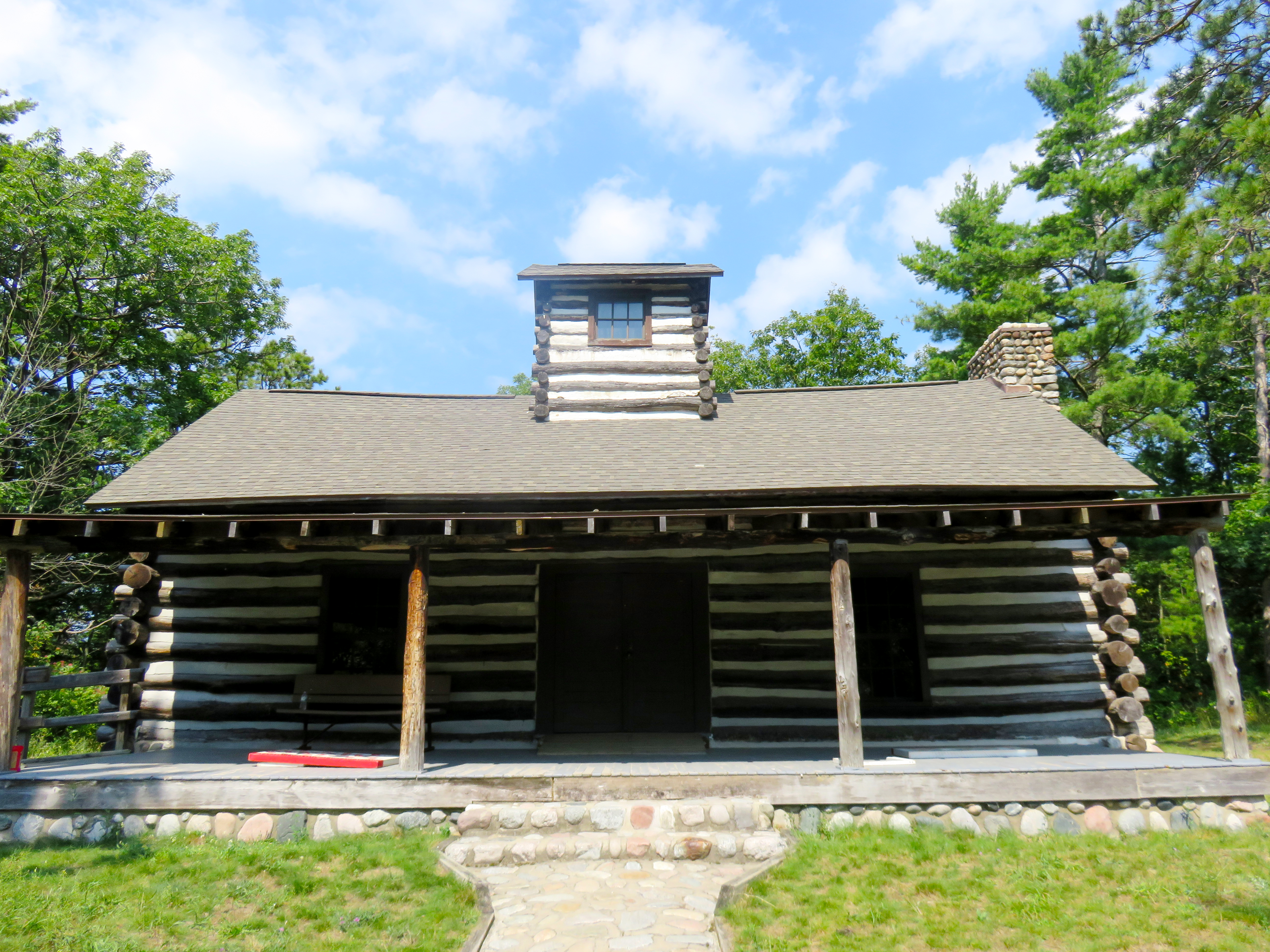
In November 1920, D.H. Day donated 32 acres of land on Glen Arbor Bay to the state for use as a state park. Day built a one room large log cabin 1923-24 on the park campgrounds as a space for events. It has a front and back porch. Today it is used for educational programs and other special events.
Located just north of the D.H. Day Campground is the D. H. Day Log Cabin, a one-story log structure constructed in 1923. This historic cabin stands alongside the Sleeping Bear Heritage Trail and can be accessed from both the campground and the parking area at Glen Haven to the west. The cabin features an open porch and a side-facing gable roof covered with dark shingles. Jutting up from the roof's center is a log cupola, also with a dark-shingled gable roof. Rising above the building roof on its right end is a large stone chimney. Visible below the porch is the building's low stone foundation.<br /> There are two 12-paned glass windows on the front of the cabin, one each flanking a central double entrance door. There is also a 6-paned glass window on the cupola's front side, tucked directly below its roofline. A stone walkway leads to the front of the cabin, where there are 2 wide stone steps positioned below the wooden porch, which extends across the full width of the building's facade. You must take one tall step up from the top-most step to reach the porch floor, which is situated about 2 feet above the surrounding grass. The overhanging porch roof is supported by 4 square wooden pillars, 2 each flanking the stone steps and 2 others standing at the porch's left and right ends. There are no railings or other barriers positioned alongside the stone walkway, the steps, or surrounding the porch. Take care as you walk along the stone walkway as although its top surface is flush with the surrounding grass, it is uneven in spots and you may encounter thick tufts of grass growing up between some of the stones. Note that the cabin's porch can also be accessed by an upward sloping wooden ramp located on the left end of the building. This ramp is flanked by wooden railings on both sides. Once on the porch, you may encounter a wooden bench placed below one or both of the 2 windows flanking the entrance. Situated on the porch directly in front of the entrance door is an upward-sloping wooden threshold, about one foot deep. The right-side double door will likely be propped open when the cabin is open for visitors. Features found inside the one-room cabin include a tall stone fireplace surround with a flat stone hearth, a display case holding various artifacts, and any number of wooden benches, tables, cabinets, or metal folding chairs. Lastly, standing near the approach to the cabin is a green sign labeled "Michigan Registered Historic Site." Text in yellow lettering reads: Early State Parks. By the end of World War I, with the rapid growth of the recreation industry in Michigan, a need for a state-wide parks system had arisen. In 1919 the State Park Commission was established. D. H. Day State Park, honoring the commission's chairman, was the first park that it set up. When state parks were transferred to the Conservation Department in 1921, over twenty other sites had been acquired, most of them, like D. H. Day State Park, beautifully located on lake shores. Michigan Historical Commission Registered Site No. 173.
Deer Lake is a very small spring fed lake and is the upper lake in the Otter Creek watershed. The average depth is 12 feet and maximum depth is 22 feet, which is deep for its size compared to other lakes in the park. White cedar Wildlife thrives in and around this lake. You might spot ducks gliding across the water, with their ducklings trailing closely behind. You might also hear the calls of songbirds perched in the surrounding trees. In the quieter moments, the occasional splash of a fish breaks the surface which adds to the peaceful ambiance. Swamp borders it to the north and south, and upland hardwoods are found along both western and eastern shorelines The access to Deer Lake is from Trails End Road. Follow a two track to the left that is rutted and narrow until you reach an area where you can walk a short distance to the lake. Deer Lake is closed to power-driven vessels from April 1 through October 31 and is limited to two-horse-power motors the rest of the year. Eleven fish species have been collected from Deer Lake, including northern pike, largemouth bass, Iowa darter, blacknose shiner, bluntnose minnow, brown bullhead, black crappie, bluegill, pumpkinseed, rock bass, and yellow perch. The majority of the fish species in the lake are bluegill.
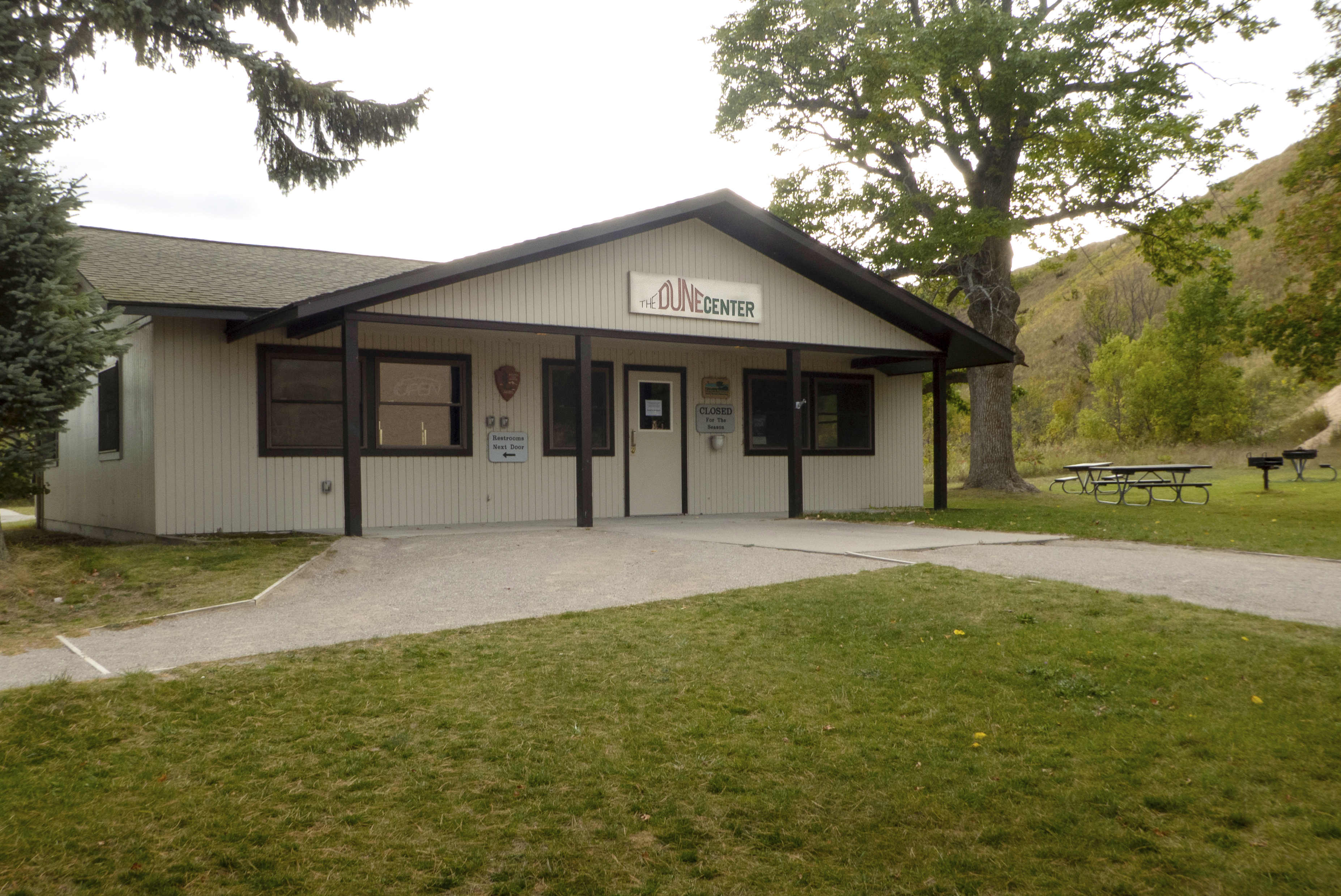
The Dune Center Bookstore is an America's National Parks sales area located at the base of the Dune Climb and features t-shirts, sweatshirts, hats, nature games, postcards, books, videos, and convenience items. Pets are NOT allowed at the Dune Center.
A concrete sidewalk leads to the one-story Dune Center bookstore, a white wood structure with a wide gable porch roof supported by 4 square brown pillars. The center's single entrance door-painted white with a fixed window located on its top half-is located approximately 4 feet directly in front of you as you step from sidewalk to porch. The porch, also concrete, spans nearly the entire length of the building's facade. Although the approach to the center's entrance is flat and without steps, take care to avoid the 2 porch roof pillars that flank the sidewalk where it meets the porch. Note that the entrance door opens outward from left to right. There are 5 windows on the front of the center, one single double-hung window located directly to the left of the entrance door and two pairs of double-hung windows, one pair each located on each end of the facade. Affixed to the triangular gable wall above the entrance is a rectangular white sign with the words "The Dune Center" painted in black, red, and dark-green uppercase letters. The tops of the red letters forming the word "Dune" appear to undulate upward and then downward, mimicking the shape of an actual sand dune. Also affixed to the facade are 3 smaller signs, one located to the right of the door and two located to the left of the single double-hung window. The sign on the right reads "Eastern National, Servicing America's National Parks," and the signs on the left include the arrowhead-shaped sign representing the National Park Service emblem and, below it, a sign that reads "Restrooms Next Door" with a black arrow pointing to the left. There is a silver metal ashtray hanging on the facade to the right of the entrance door. The tray's cylindrical base is located approximately 3 feet above the porch floor. The Dune Center is open seasonally from late spring through Labor Day.
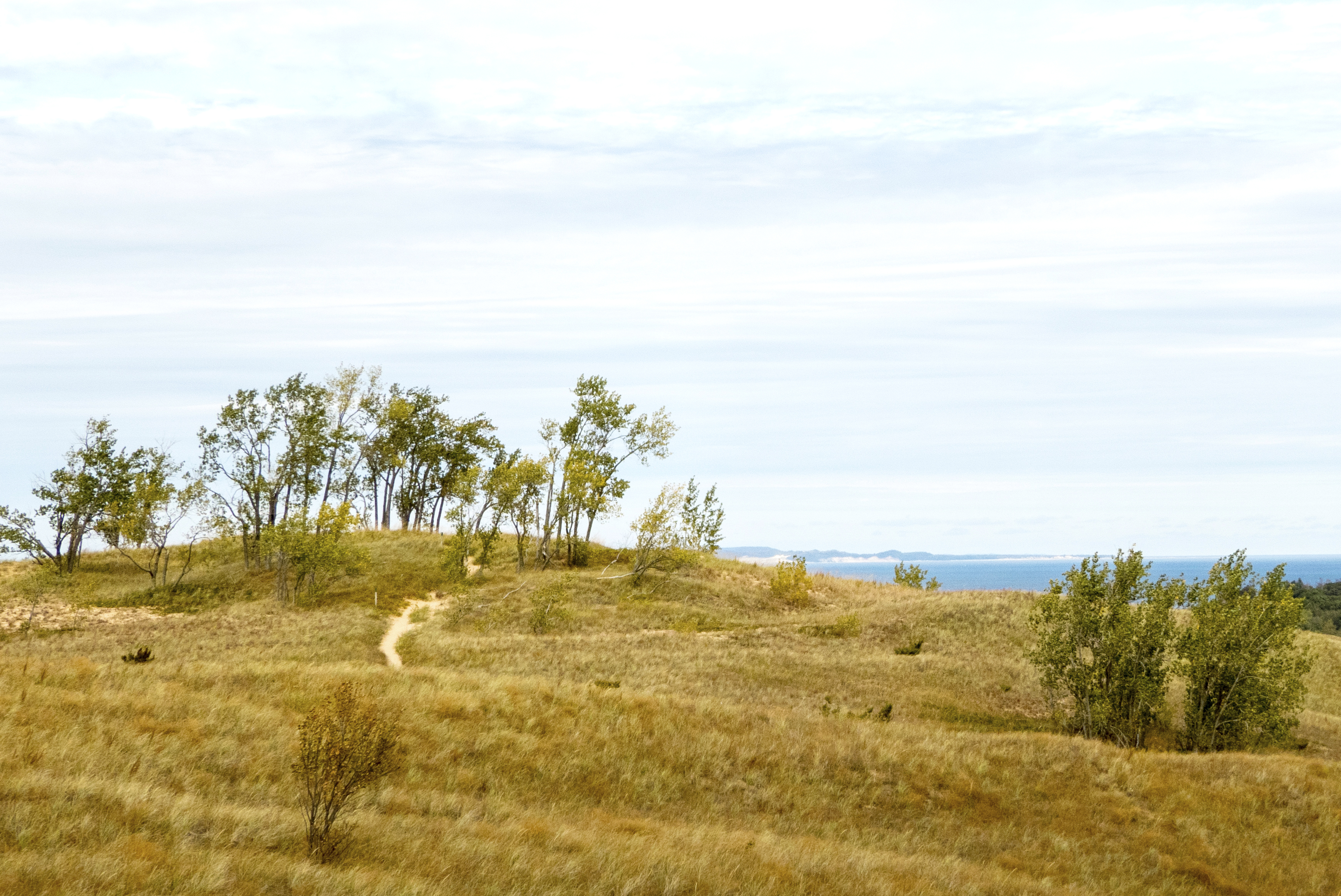
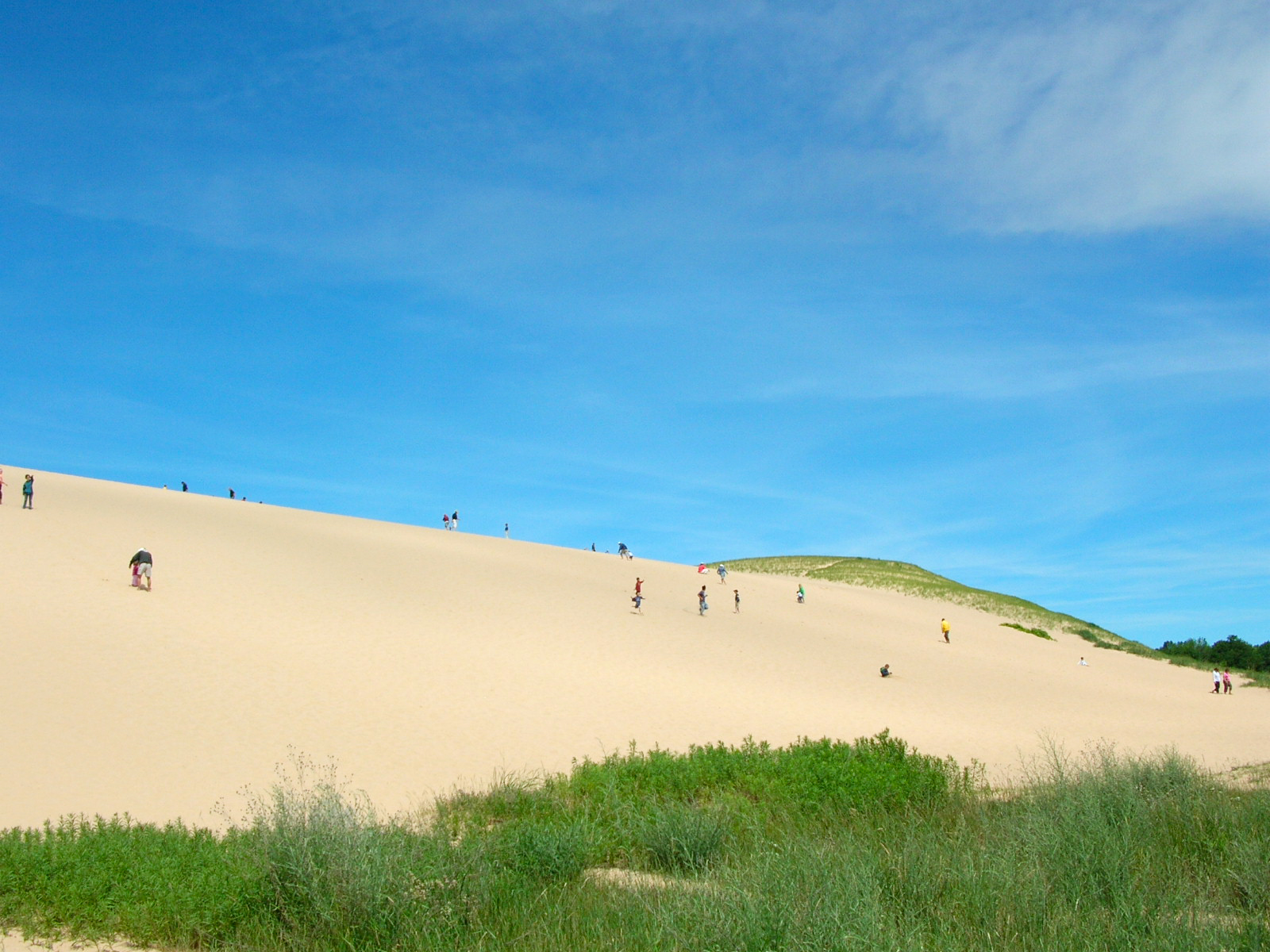
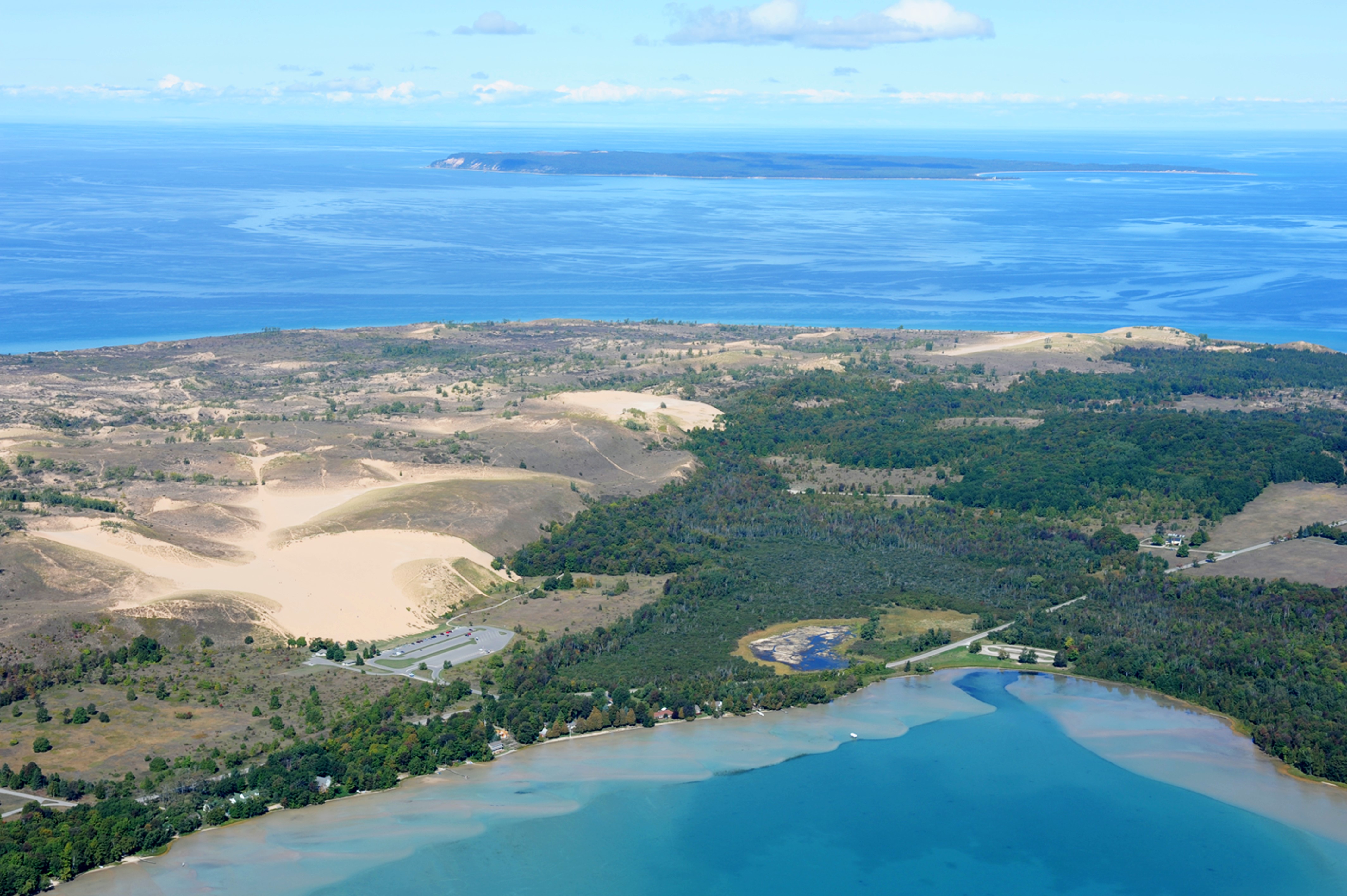
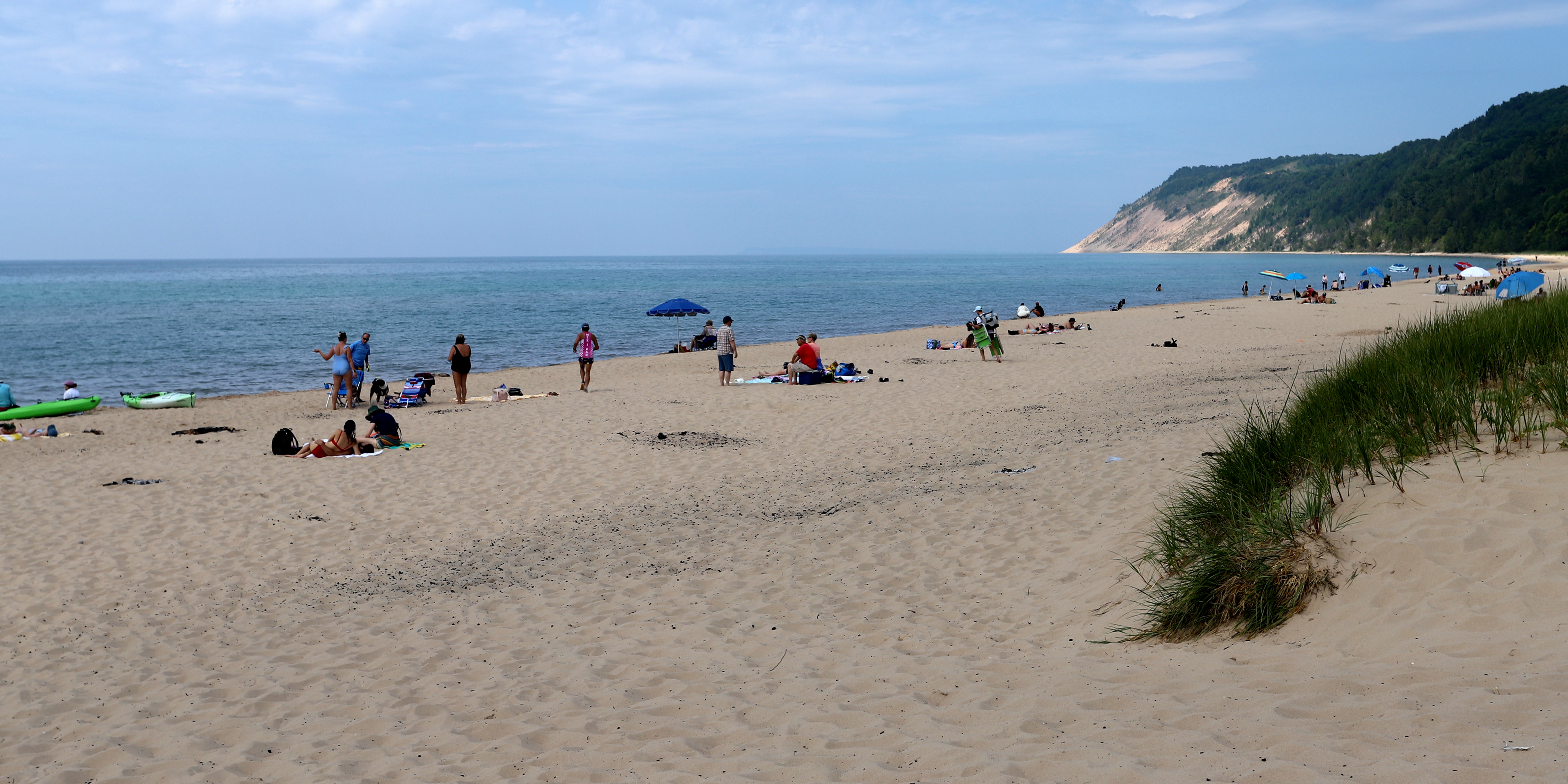
It's the most famous attraction at Sleeping Bear Dunes National Lakeshore and a Midwest rite of summer, loads of fun for the young and young at heart: a 284-foot-high wall of glistening white sand that tourists climb for fun-the Dune Climb. Climbing this dune takes at least 10 minutes and is a strenuous hike that will fill your shoes and pockets with sand, and take your breath away. If you get to the top of the first dune you will have a good view of Little Glen Lake.
The Dune Climb is 110 feet high, or roughly the equivalent height of an 11-story building. From the adjacent parking area, you must step through a large grassy area before reaching the base of the dune, which may be climbed on foot. This dune, which resembles a wide, flat-topped volcano rising out of the surrounding landscape, is largely without vegetation. Before you reach the Dune Climb, note that there is a single drinking fountain located inside a square concrete area to your right. At the base of the dune on its far left end is a small roofed sign with a small box holding pamphlets affixed to the sign's support pole. Once you reach the top of the dune, you may turn around to face a wide view of Glen Lake, which is visible beyond the trees lining the site's parking area. Also atop the dune is a hilly 3.5-mile hiking trail that travels through the high dunes plateau to Lake Michigan. Walking this trail can prove strenuous for inexperienced hikers and may be a 3- to 4-hour trip. As there is no shade on the Dune Climb or along the Dunes Hiking Trail, it is suggested that hikers bring water, sunscreen, a hat, and reliable shoes. This site's wayside panel, entitled "Sand and Ice," is mounted inside a wooden frame on 2 legs, approximately 7 feet tall by 4 feet wide. Featured on the panel's top half is a large aerial photo of the Dune Climb, the dune plateau, and the nearby parking lot. Text below the photo tells us: Without departed glaciers, the dunes would not be here. Melting continental ice left this ridge of sand and gravel. Steady winds off Lake Michigan have plucked at the sand grains, propelling them inland, depositing a veneer of dunes on top of the glacial ridge. Even now the dune is adrift, as part of the slope advances toward Glen Lake. Pick out a nearby tree or shrub; return in a few years and it may be buried. Beyond this wall of sand is a windswept plateau covered with small stones, an occasional ice-abandoned boulder, a few tufts of vegetation, and sculpted dunes. On this side are good views of Glen Lake. But it is an hour's hike to the steep bluffs 400 feet above Lake Michigan.
To survive in the dunes is no easy task. Flora and fauna deal with strong sunlight, poor soils, and constant winds. The wind action alone can dry out plants, expose root systems, or even completely bury vegetation, including trees.The cottonwood is the only common tree of the dunes and is well adapted to the dune environment.
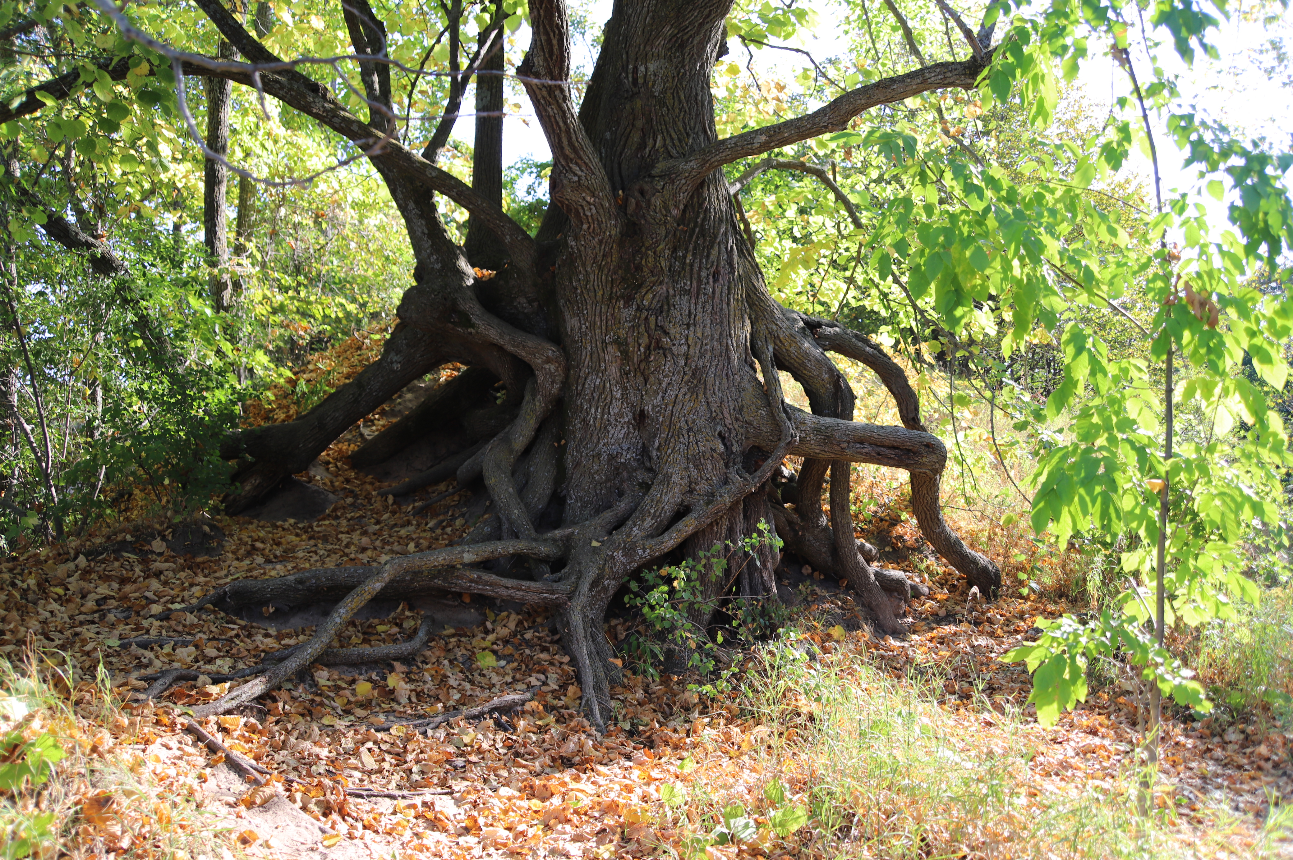
As you leave the dunes area and step into the site's maple-beech forest, you will encounter a basswood tree located on your left. This tree is located across the street from a pullout on the right. The rough bark on both the tree's trunk and its wide-stretching limbs has a mottled dark gray surface. Twisted around one another and extending outward several feet just above and along the sandy ground surrounding the basswood's trunk are a series of gnarled branches and exposed roots. Take care as you approach the tree, as these branches and roots may present a tripping hazard.
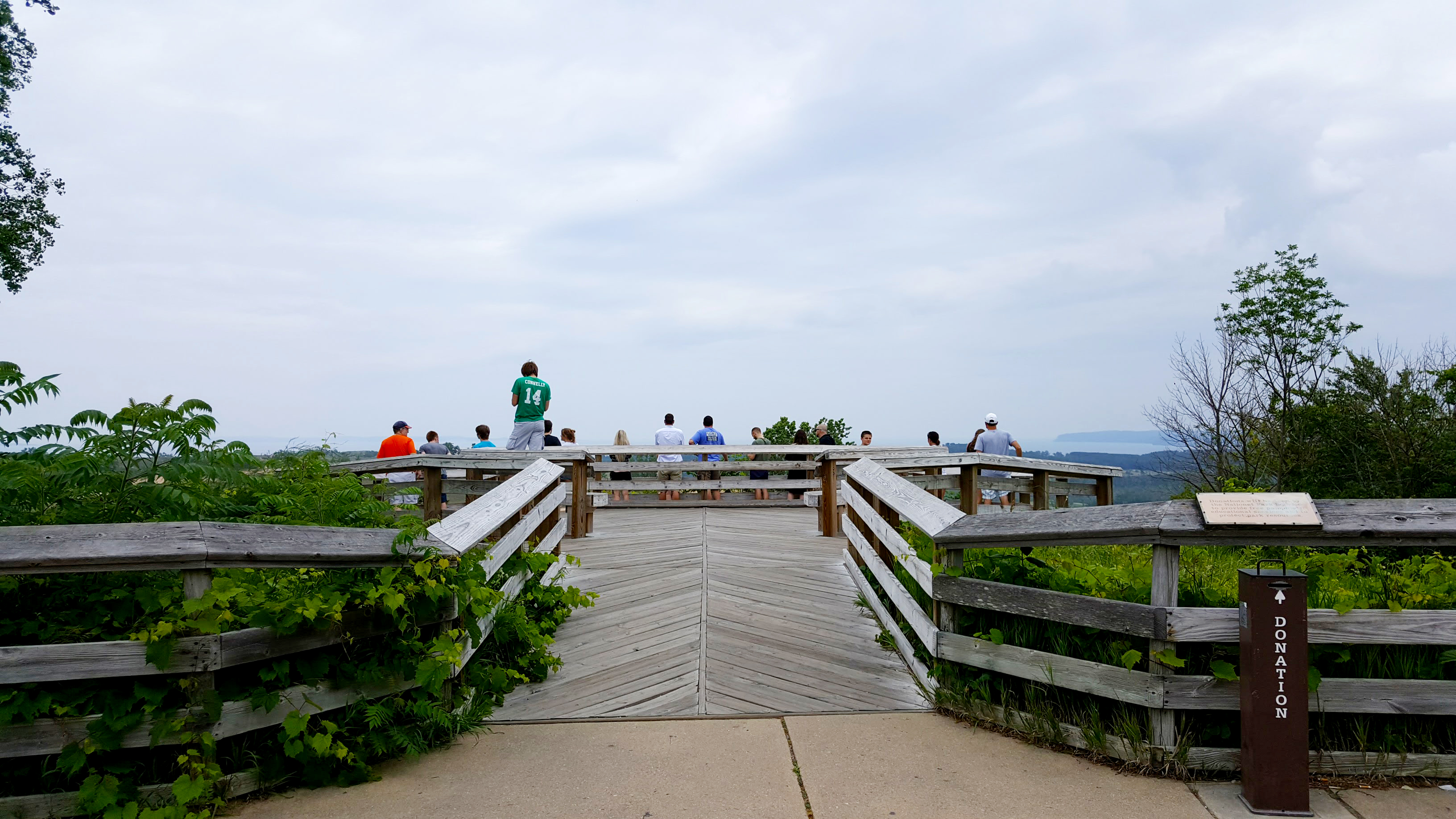
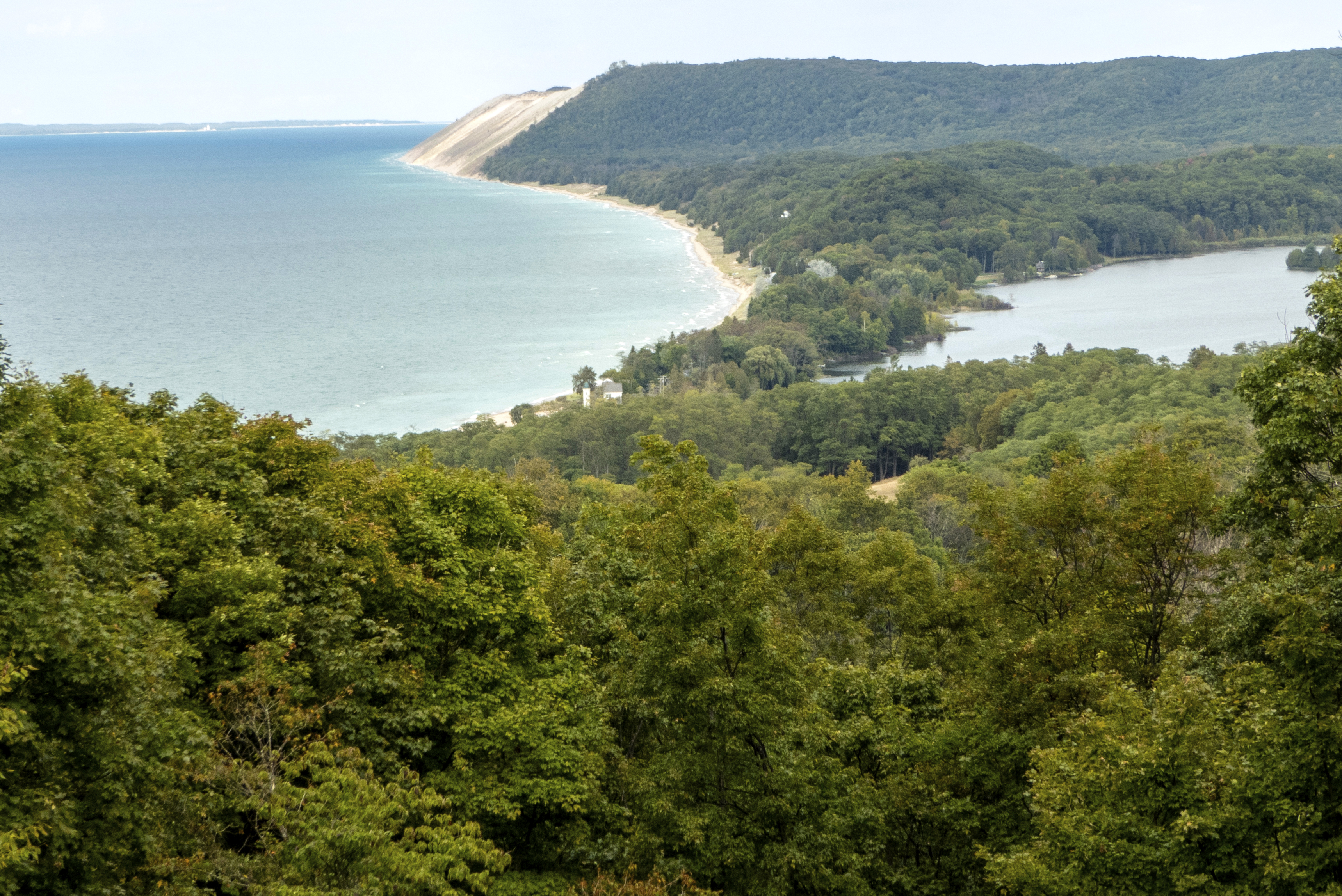
Wow! Standing in the middle of an approximately four square-mile area called the Sleeping Bear Dunes complex, the panoramic vista from the Dune Overlook includes Glen Lake and its surrounding rolling hills, the historic, privately owned D. H. Day farm with the huge white barn, the spectacular landscape of the Sleeping Bear Dunes, and a dramatic glimpse of Lake Michigan, Sleeping Bear Bay, Pyramid Point, the Manitou Passage, and both North and South Manitou Islands.
Leading from the sidewalk running alongside Dune Overlook is a wide wooden ramp, slanting slightly uphill, that opens onto the top level of a 2-level deck. The wooden deck, which holds 6-foot-long benches placed along its side edges, is surrounded by an approximately 3 1/2-foot-high safety railing. The deck ramp is also flanked by railings on both sides. Directly in front of you as you stand at the edge of the deck is a large sandy area without vegetation, otherwise known as a "blowout." Beyond this windswept area are perched dunes dotted with native grasses and other plants. This overlook is located on the eastern edge of the dunes. The Dune Overlook offers a panoramic view, from left to right, of Lake Michigan, South Manitou Island, North Manitou Island, Pyramid Point, Alligator Hill, and Glen Lake. Also visible in the distance is the historic D.H. Day farm, most notably the farm's large white barn with dark roof.
Dunes Hiking Trailhead is located at the top of the first dune to the right. This is one of the most difficult trails in the park. Totaling 3.5 miles from the Dune Climb to Lake Michigan. 27 blue topped posts mark the trail. Be sure to wear sunscreen, take enough water, and wear (or at least take along) hiking shoes or sandals.
The Dunes Trail, a 3.5-mile round trip, takes devoted hikers across a sandy dunescape to the cool waters of the Lake Michigan. This hike is challenging. If you have trouble scaling the Dune Climb at the beginning, think twice before continuing on as you will have to climb five more dunes of various heights. The hike up and down over sand dunes offers multiple views of Glen Lake and Lake Michigan, and the sparse dune ecology. The Dunes Trail goes straight up a huge dune right away. And for most families, stopping here and letting the kids play on the huge dune might be the way to go. The kids can play for hours on this formation tumbling down the hill over and over again. Many people get sucked in and want to hike to the lake, but be warned: Lake Michigan is not just over that next dune. The trail's hilly, sandy terrain can be very difficult to traverse, and a round trip may take several hours if the temperatures are unfriendly. This trail has worn out the most experienced hikers. Pack water and wear appropriate footwear. Be prepared for hot sand and no escape from the sun. The rolling dunes are beautiful and vary in cover from open sand or patches of beach grass and wildflowers to a lone cottonwood here and there. The sun can be relentless on the dunes when the skies are clear and shade can be tough to come by. Stopping to take in the gorgeous views of the northeastern shore of Lake Michigan from the dunes is an excellent excuse for a break. The hike is a workout for many people, but the isolated beach along Lake Michigan and its refreshing surf is a great place to recuperate before heading back along the same route.
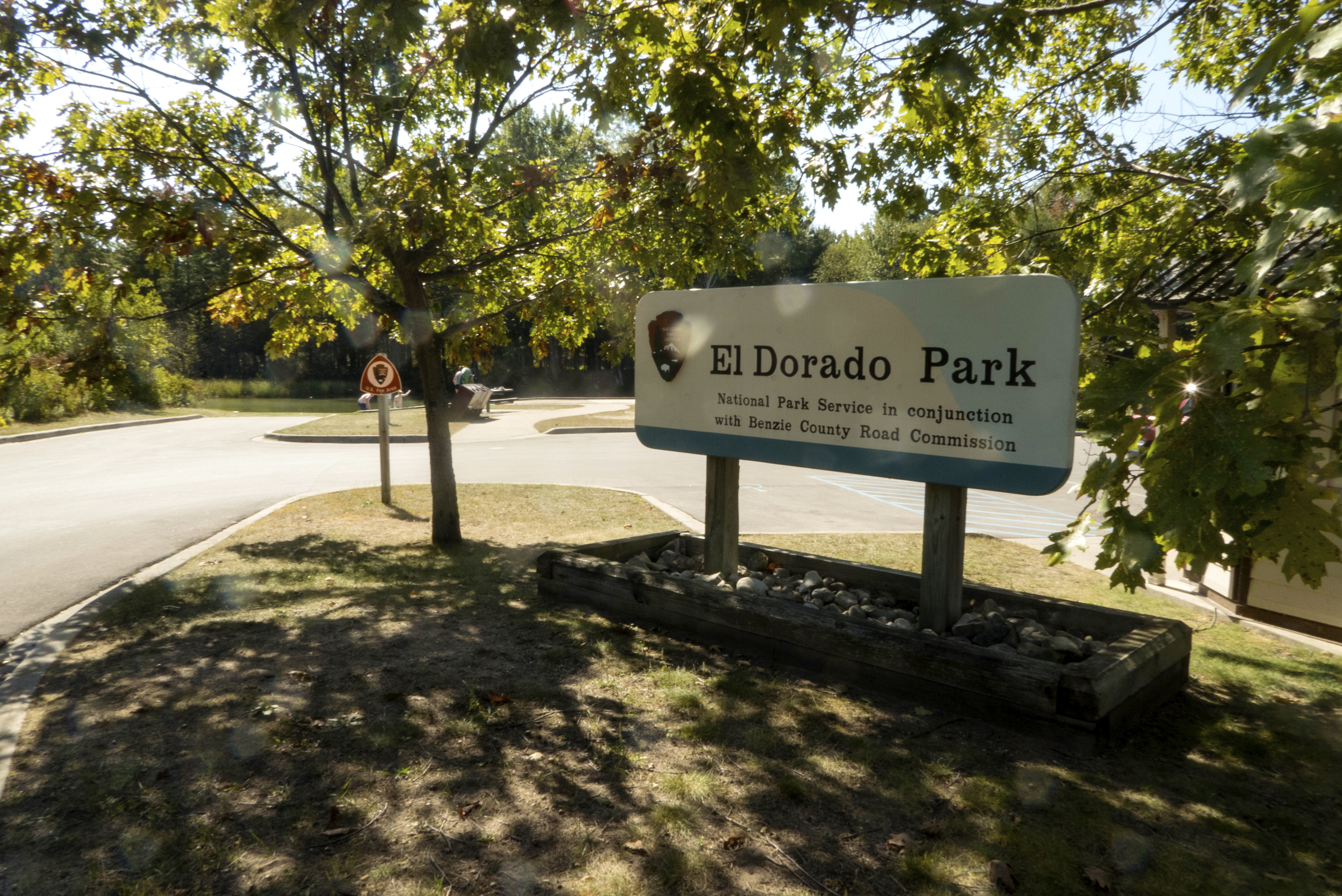
A great place to put in your tube or to take a break from your drift downstream, El Dorado Park is a mile from the mouth of the Platte River-about a half an hour float. The last landing before Platte Point, El Dorado offers picnic tables, a vault toilet, a launch site, and parking. Fish or watch the river from a deck overlook. Handicapped parking is available.
The El Dorado Landing, which is located near the Platte River Campground, allows park visitors access to the last stretch of the Platte River. Here you will find an approximately 15-foot wide boat ramp and a trapezoidal-shaped wooden observation deck measuring about 15 feet wide and 10 feet deep at its central, or deepest, point. A paved walkway originating at the nearby parking area leads directly to the deck. This walkway is flanked by 2 metal picnic tables with attached benches. The table to the right of the walkway is placed on the grass; the table to the walkway's left is placed on a concrete patio and is therefore wheelchair-accessible. There are 3 trash and recycling receptacles located to the left of the walkway as well, a few feet before you reach the concrete patio holding the picnic table. The paved walkway, which also extends left and right in front of the deck's back edge, is flat and there are no railings. The boat ramp, which is located a few yards to the left of the observation deck, is constructed of an open concrete grid that allows grass to grow around the small square sections making up its surface. Extending from the left end of the paved walkway in front of the deck's back edge is a concrete grid walkway that leads to the boat ramp. Take care as you step toward the front of the deck and along the concrete grid walkway to its left as there are no railings, only a wooden curb measuring about 6 inches high lining their outer edges-or the edges closest to the water.
Breathtaking . . . water so clear and blue . . . bucket-list worthy . . . best view anywhere on the shoreline . . . amazing . . . incomparable sunset . . .picture-postcard sight. . . jaw-dropping . . . not like anything else in the Midwest. Interested? Then don't miss the Empire Bluff Trail. The 1.5-mile round-trip trail climbs through a beech-maple forest rife with wildflowers to a high, coastal bluff featuring the iconic double-dune view.
Standing in the grass just beyond the end of a wooden walkway leading to the 1.5 mile-long Empire Bluff Trail is a wayside panel with a wood-framed boot brush mounted atop a metal slat connecting the wayside's 2 metal legs. Situated flush on the ground in front of the brush is a small rectangular metal grid. The panel, entitled "Stop Invasive Hitchhikers!", features a large photo of a row of people wearing hiking boots standing on a wooden walkway or bridge overlooking a stream. Only the hikers' lower legs and footwear are shown in the photo. Text below the panel's title reads: Use this boot brush before and after your hike to remove dirt and invasive seeds. Seeds of invasive plants hitchhike on your shoes' lugs and laces, allowing invasive plants to spread quickly and crowd out native plants. It takes time and costs money to remove the invaders. Stopping the unintentional spread of seeds is the best way to protect the native landscape. Located to the right of the text is a small circular photo of a pinkish-purple plant identified as "spotted knapweed." A caption below the photo tells us: The hitchhiking seeds could be spotted knapweed. This invader crowds out native plants and produces toxins, preventing other plants from growing nearby. Always clean seeds from shoes and gear before and after visiting any area. Please note that there are no railings on the wooden walkway, which is elevated about 5 inches from the ground on its left side only as you face the wayside panel. The entrance to the dirt and gravel surface of the Empire Bluff Trail is located directly to your right as you stand at the panel; the trail runs perpendicular to the wooden walkway. Standing to the right of the trail is a wood-framed structure that holds informational signs and a map of the trail. Trail map brochures are also available here. Located in the grass a few yards to the right of the trailhead is a small building with a gable roof that holds a single vault toilet. The door is located on the front of the building and opens outward from left to right. You must take one tall step up into the building.
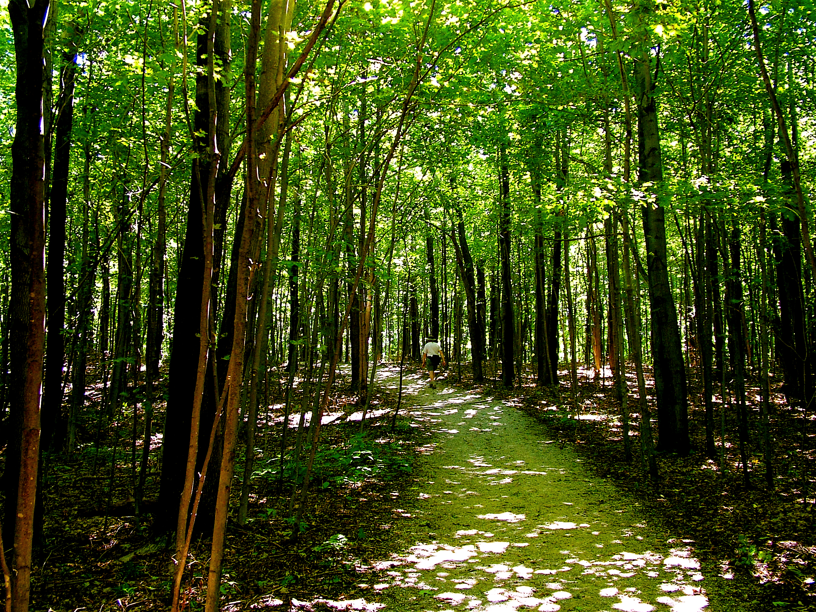
Stop and look around at post #3. This section of trail shows one of the most important types of Northern Hardwood forest in Michigan, the Beech-Maple forest. This forest consists of primarily sugar maple, red maple, and beech. Though, in disturbed areas where sunlight shines below the tree canopy, more sun-loving species, such as paper birch and quaking aspen are often found.
The third marked stop along the Empire Bluff Trail, as indicated by a post carved with a number 3, is located alongside an expanse of tall deciduous trees surrounded on the ground by areas of sparse vegetation. This is part of the beech-maple forest that covers much of the park. In summer, these trees case a dense shade over the ground, which is dotted with only those plants that are able to tolerate low light levels. Forest wildflowers bloom in the early spring before the leaves appear on the trees.
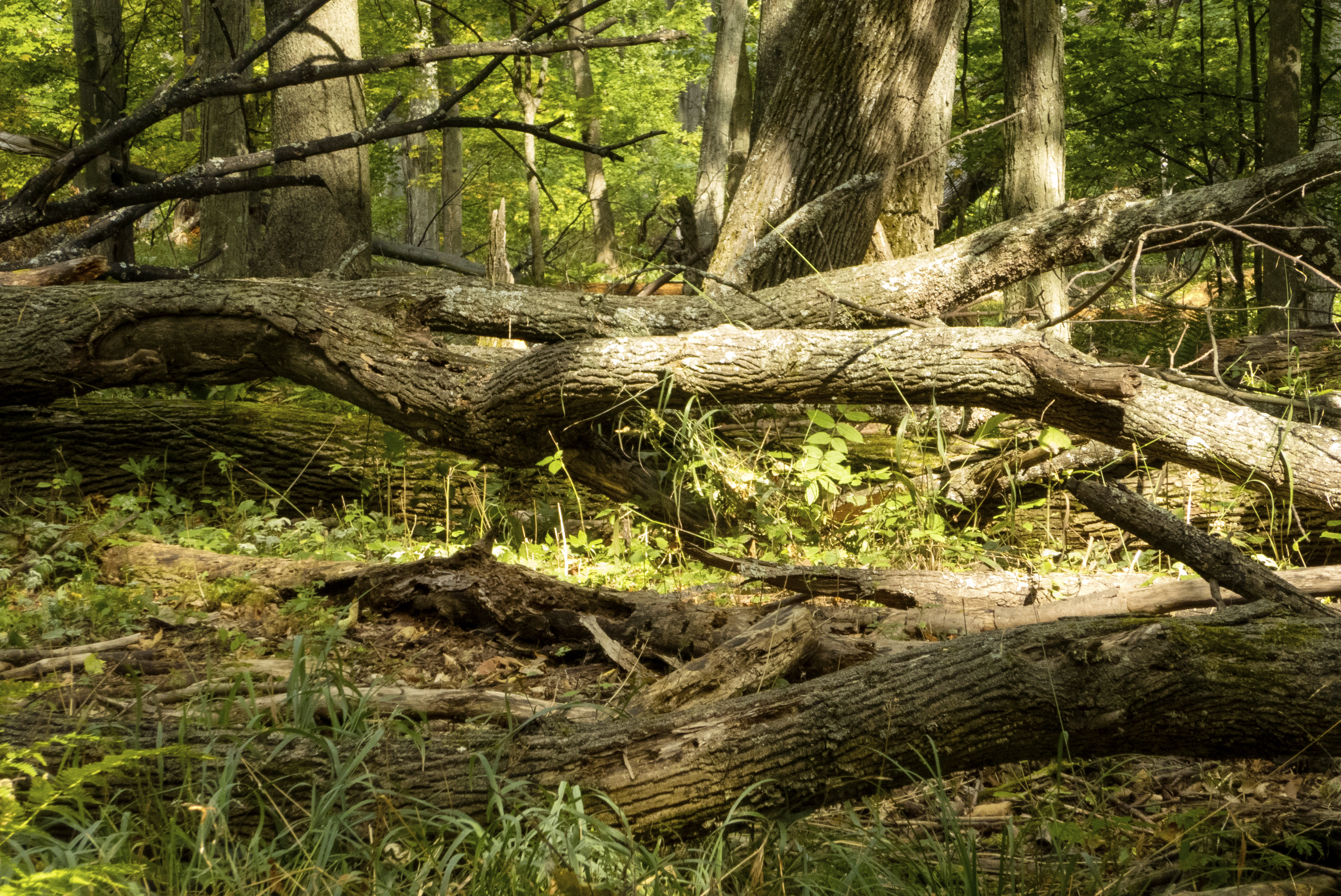
Near the post marked 5 and actually many locations along the trail, you can see various decomposing logs and fallen trees. Bacteria, lichen, fungus, moss, and seedlings take advantage of the nutrients, moisture, and sunlight made available to them by these fallen trees. Large trunks and limbs of which are often referred to as nurse logs. Why do you think that is?
The fifth marked stop along the Empire Bluff Trail, as indicated by a post carved with a number 5, stands alongside another section of beech-maple forest where several fallen logs litter the ground. These decomposing, or rotting, logs-along with other fallen trees throughout this area-are part of the life cycle of the forest. Bacteria, insects, fungi and mosses break down dead wood and utilize its nutrients. As decomposition advances, more complex plants such as flowers and tree seedlings also use the rotten wood for nutrients.
Here you go . . . the breathtaking part. At post 6, you are perched about 400 ft. above Lake Michigan on a perched dune (a dune made of several feet of sand on top of hundreds of feet of glacial moraine, geological debris, in this case from the last Ice Age). From here, weather permitting, you can see Point Betsie, South Manitou Island, the southern portion of the Sleeping Bear Dune plateau, a lot of Lake Michigan, Platte Bay, Platte River Point, Empire and South Bar Lake.
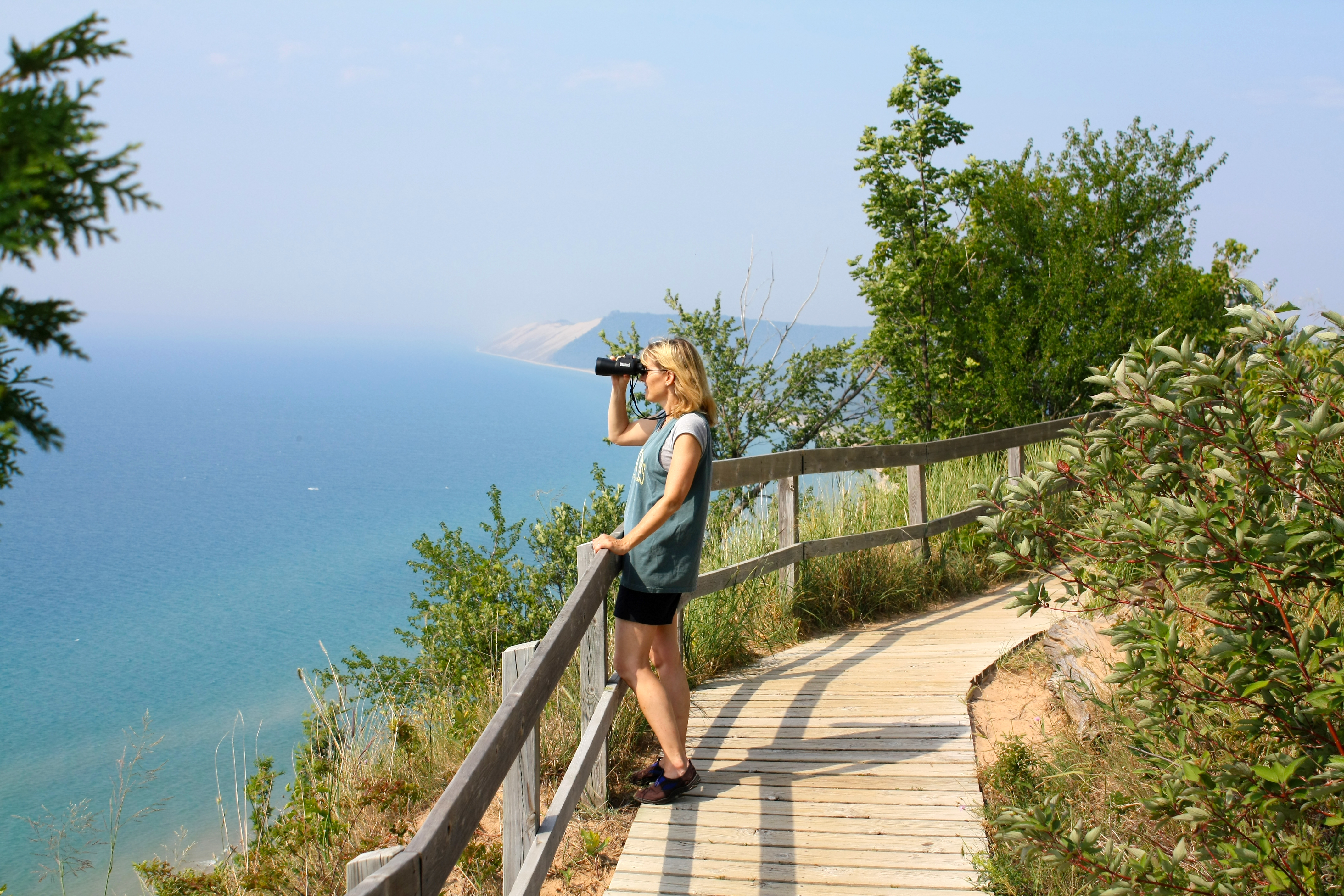
A wooden walkway leads to the Empire Bluff Scenic Overlook, which offers a panoramic view of Lake Michigan, the Sleeping Bear Dune, and several other features of Sleeping Bear Dunes National Lakeshore, including Platte Bay, the Village of Empire, and South Bar Lake. Also located about 7 miles offshore is South Manitou Island. This scenic overlook, which is located about 400 feet above Lake Michigan, is the sixth numbered stop along the Empire Bluff Trail. Although much of the upward-sloping walkway leading to and from the overlook is without railings, along the section encompassing the overlook itself there is an approximately 3-foot-high and 30-foot-long safety railing on the walkway's outer edge only. This overlook section is situated above the steepest part of the bluff descending down to the lake. The bluff alongside the overlook includes sections of bare sand, low vegetation, and both deciduous and evergreen trees. Attached to the railing is a small sign entitled "Fragile Dune Grasses." Text on this sign reads: Help us preserve this fragile landscape. Please do not hike beyond this sign. Please use designated hiking trails. Dune grass binds the sand (and) helps stabilize the dunes. Standing on a short wooden pole planted in the steep dune rising above the trail is another smaller sign marked simply "launch area." This is a parasail launch area. There are 3 benches located alongside the walkway, which forms a wide loop in front of the overlook. One bench is situated to the left, or outer, edge of the walkway several feet above the overlook, and the other 2 benches are located side by side directly behind you as you stand facing the lake near the top section of the overlook.
About .5 miles from the Empire Bluffs trailhead is a bench marking the South Bar Lake overlook. From here, you can take in the stunning view towards the north from which you can see South Bar Lake and the sweep of Lake Michigan's Platte Bay all the way to the Sleeping Bear Dune.
The South Bar Lake Overlook on the Empire Bluff Trail offers a view of both Lake Michigan and South Bar Lake. As you stand facing the lakes, the 2 bodies of water are separated by a thin strip of forested land with Lake Michigan located on the left and South Bar Lake situated on the right. This view is framed by tall trees that are part of a vast forested area that separates the overlook from the lakes. There are no railings at this bluff overlook, which is edged with low vegetation only. It is suggested that you stay on the overlook's dirt surface, which begins about 4 feet back from the bluff's outer edge. Here you will encounter a wide bench that is placed parallel to the lake view.
The hilly terrain and scattered boulders are evidence of glaciation. Only about 11,800 years ago, the last glacier melted from this area. As Glaciers move across the land, they pick up rock and soil, and as they melt, they deposit the debris irregularly to form hills and valleys. Glacially transported boulders located far from their point of origin, such as this one perhaps from Michigan's Upper Peninsula or Canada, are known as erractics, literally "travelers."
Standing to the right of the Empire Bluff Trail are a series of 6 square wooden posts, each measuring about 3 ½ feet tall, with the numbers 1 through 6 carved into their respective top surfaces. Located at the first stop, as indicated by a post carved with a number 1, is one of many large boulders, some dotted with green moss, jutting up from the ground alongside the trail. These boulders are what remain of the debris deposited from the melting glaciers that existed here during The Ice Age.
The glacial soils around Sleeping Bear are quite sandy and not very fertile for farming. However, certain crops, including hay, can be grown here successfully. From post #2, you can see a metal sculpture. Oh, but wait, that's actually a piece of rusted farm equipment from the time of the Great Depression.This McCormick Deering No. 7 mowing machine was manufactured between 1929 and 1940.
The second marked stop along the Empire Bluff Trail, as indicated by a post carved with a number 2, is located near several pieces of old farm equipment dating from the early 20th century. These items, which are strewn on the ground at the side of the trail, include a wide metal hay rake and a large horse-drawn mower identified by the park as a McCormick Deering Number 7 mowing machine. With the development of modern farm equipment, many pieces of old machinery such as these were left abandoned in the fields of the many farms that once thrived in this area.
While the sandy tree-covered dunes of this region are not rich farmland, the temperature, drainage, growing season, and available soil nutrients in these somewhat humus-enriched "gray dunes" work well for many species of trees. In particular, the Grand Traverse region, known as the Cherry Capital, is well suited to growing various kinds of fruit trees. In about 1910, the Empire Lumber Company planted extensive orchards on the logged-over lands.
The fourth marked stop along the Empire Bluff Trail, as indicated by a post carved with a number 4, is situated near a meadow containing several fruit trees. This is the location of an extensive old orchard planted here on logged-over lands by the Empire Lumber Company around 1910. The Empire Lumber Company orchard extended all the way from the Village of Empire up the hill to this meadow. The apple and plum trees growing here today do not seem to be from these old orchards, however, but may have sprung up from fruit discarded in the area.
This dazzling beach, located at the mouth of Otter Creek, is an ideal place for the whole family. The creek gently empties into Lake Michigan. Kids enjoy wading upriver into the belly of the forest and letting the current drift them toward the lake. **Leashed pets are allowed to the right of Esch Road when facing the water. NO Pets are allowed to the left of Esch Road.**
A sandy path between low, grass-covered dunes leads to Esch Beach, a narrow stretch of sand located at the mouth of Otter Creek. This beach is located at the end of Esch Road, about 3 miles south of Empire on M-22. Parking is available along the road, and there are bathroom facilities nearby. Esch Beach offers visitors opportunities to swim or wade in the shallow creek bed or to view the wildflowers and other local fauna lining the banks. As you approach the water's edge, you may encounter a wide band of small stones underfoot. Affixed to a pole standing in the grass to the right of the entrance is a green sign with white lettering that reads: "Benzie County. Boat Landing. Do Not Block." Other smaller signs located in the grass to the left of the path indicate that off-road vehicles, camping, and pets are not allowed.
“Evolution of a Lighthouse” is a slanted outdoor panel that is thirty-six inches wide by twenty-four inches high and attached to a frame with brown metal legs. On a light blue background, black letters: “Evolution of a Lighthouse” The light tower in front of you with its connected keeper’s quarters was the last in a series of lighthouses that stood on this site. Each replacement improved on the effectiveness and livability of the previous structure. Still, lighthouse keepers struggled with poor conditions. Burrowing animals and the shifting dune environment undermined foundations, while moisture collected inside the buildings, coating the walls with ice in the winter. Many keepers didn’t stay long or lived elsewhere on the island, and one blamed the damp dwelling for his wife’s death from tuberculosis. Below on a light brown background, a drawing of a small conical white tower with a light on top: 1839 STRUCTURE The first lighthouse was a thirty-foot tall stone tower with a simple stone dwelling that stood nearby and served as the keeper’s quarters. Experts suspect this first lighthouse and dwelling were replaced due to poor workmanship. A tower of identical design still stands today at the Old Presque Isle Lighthouse on Lake Huron. To the right a drawing of a three-story square stone and brick building. On the top left is a small square light tower. 1858 STRUCTURE A new lighthouse was built that integrated a wooden light tower atop a three-story keeper’s dwelling. This brick dwelling still stands in front of you today, minus the light tower. The first fog signal building was built the same year. Below: “Puddles of water often stood on the floor from the moisture running down the walls…” Martin N. Knudsen, Head Keeper 1882-1889. To the right, a drawing of a tall conical white light tower. A walkway with a black metal rail is near the top of the building. A large light inside a structure of windows is above the walkway. It is covered by a black metal top. A long white structure is attached to the bottom portion of the tower and is attached to a three story square stone and brick building on the far right. “A tower of greater elevation is required.” T.H. Stevens, District Inspector 1871 STRUCTURE Increased shipping traffic led to the construction of the 1871 light tower, which, at one hundred feet tall, was designed to be visible from a greater distance. A covered passageway connected this newest tower with the 1858 keeper’s quarters. One of the tallest light towers on the Great Lakes, it has been carefully restored and casts its familiar light each summer night. A combination of stout oak logs and stone anchor the tower to bedrock a hundred feet beneath the shifting sands. Below the drawing of the light tower is a rectangle with the exterior and cross sections of the structure of a light tower: Standard lighthouse designs were created by the U.S. Lighthouse Service to minimize construction costs and keep up with the demand for more lighthouses. This design was used for eleven other lighthouses on the Great Lakes.
Mary Faust was a botany college student when she first fell in love with the views of the Glen Lakes and the Manitou Passage from the bluff with the log slide. Logs were skidded down this slide during the winter and taken to D.H. Day's lumbermill. Later, she and her husband, George, purchased the property from Glen Haven entrepreneur D.H. Day before hiring Chicago architect Frank Sohm, a student of Frank Lloyd Wright, to design their vacation home.
The Faust Cabin, which was built by George and Mary Faust in 1929, is a wide 1 ½-story log structure with a side-facing gable roof and a stone foundation. The cabin's tall chimney, which extends from the ground to above the roof on the building's right side, is also constructed of gray stone. The cabin is perched on a hill next to Inspiration Point, overlooking Glen Lake. Positioned on the gable roof above the entrance is a wide shed-roofed dormer with 3 pairs of small windows positioned along its front. A smaller shed roof supported by rough-hewn log rafters and a slender log bracket on its left end only shelters the cabin's entrance vestibule, which juts out about 2 ½ feet from the structure's facade. This smaller roof also shelters a second, narrower door situated to the left of the vestibule. All of the windows in the cabin have 4 panes-a row of 3 small rectangular panes placed above one large pane-and are trimmed in light-colored wood. This window type is reminiscent of the Craftsman style of architecture. The wide front door on the front of the entrance vestibule is boarded up, and access to the building is not available at this time. Take care as you walk around the overgrown yard in the front of the cabin as you may encounter tripping hazards including an old picnic table with attached benches and a large tree located in front of the facade's left side. Positioned to the left of a dirt path flanked by tall vegetation, and facing the lake, is a bench constructed of large stones. The bench, which has high arms and a high back, is tucked between several tall tree trunks. In front of the bench is a low concrete step, measuring a few inches high. From this location, visitors are offered panoramic views of Glen Lake and Alligator Hill. Take care as you approach the bench as the dirt path in front of the bench continues to decline toward the lake.
Descendants of the Howard Foote family--one of the original members of the Cottage Row summer colony--own the only cottage that is currently maintained and occupied. Howard Foote built his second Cottage Row house on this lot in 1901. Following the death of his wife, ownership of the property passed to Foote's children. The house was destroyed by fire in 1935. In its place, Foote's daughter, Shirley Foote Alford, erected a small house purchased as a kit from Sears & Roebuck.
The Howard Foote Cottage is a small one-story structure with a gray-shingled hip roof over its main section and an intersecting gable roof over its enclosed front porch. This cottage, which was built in the mid-to-late 1890s, is clad in clapboard siding, once painted white but now largely turned gray with age. A window located just to the right of the porch, which extends only part way across the building's facade, is covered with a wooden board. The tall foundation supporting the porch is constructed of round, uniformly sized river rocks. The porch itself is enclosed on 3 sides with windows, a knee wall, and a screen door located on the porch's right end. Situated below the door are 4 steps edged on their left side with river rocks but no railings. The door's threshold appears to be several inches above the top step. Decorating both the wide triangular gable above the porch and the foundation of the main structure are scallop-shaped wooden shingles, also painted white. A single red brick chimney juts out from the main section's hip roof.
Resting about 300 yards off the southern coast of South Manitou Island is one of of Michigan's most visible shipwrecks, the Francisco Morazan.Gambling with late season Great Lakes weather, but wanting to make one last trip before winter, the Francisco Morazan left Chicago on November 27, 1960. The steel-hulled Liberian freighter was bound for Holland via the St. Lawrence Seaway loaded with 940-tons of general cargo.
A 2 ½-mile hike west from the dock along South Manitou Island's southern shore takes you to a bluff overlooking the shipwreck of the Francisco Morazan, a 247-foot-long cargo freighter that was lost in a snowstorm here on November 29, 1960. The Morazan, which ran aground rocks about 300 feet off the island's south coast, is known as the largest and most exposed shipwreck of the more than 50 known wrecks that have occurred in the waters surrounding the Manitou Islands. The Morazan's massive hull-broken but with its tall stack still intact-sits in shallow water. On the bluff you will find a small wooden platform with a wooden railing running along its front edge and a wayside panel providing additional information about the ship. What remains of the Morazan is now home to gulls and double-crested cormorants, which you may see perched atop the ship's tall steel lifeboat davit arms, 2 each located on both the port and starboard sides.
The Werner Farm is a 204-acre parcel of land was claimed by Fredrick and Margaretta Werner, who arrived from Germany on 18 September 1855. Their farm dates to the late 1850's or early 1860's and is the oldest maintained farm in the Port Oneida Historical District.
A paved driveway provides access to the Werner Farm, located on the west side of M-22 just west of the intersection with Thoreson Road. This farm is also close to the trailhead of the Bay View trail. The farm dates to the late 1850s or early 1860s. The first building you will encounter as you enter the property is a 2-story light blue-gray clapboard farmhouse with a red-shingled gable roof. On the left side of the facade, or the side closest to the driveway, is what appears to be an enclosed porch lined with several windows flanking a single entrance door. This wooden door, which is covered by an outer screen door, is painted dark bluish-gray, as is the wooden trim surrounding the house's many windows. Hugging the front of the house are several sizeable bushes and trees, including a tall leafy green tree rising like a wide column in front of the porch's front left corner. The top of this tree reaches high above the farmhouse roofline. Other buildings at the farm include a large weathered gray barn, a small white clapboard outhouse, a small stone garage with a red-shingled gable roof, as well as sheds and other outbuildings of various sizes. Flanking the driveway are two wooden poles, each about 5 to 6 feet tall, with 5 rows of metal fins spaced evenly below a top cover resembling an angled roof. These structures house yard lights. Jutting out of the ground to the side of one light pole is a cylindrical well pipe, about 1 foot tall. Take care to avoid these objects as they may present tripping hazards.
The Philip A. Hart Visitor Center is located on M-72 just east of the intersection with M-22 in Empire, MI. You will find a wealth of information about the park and the natural and human history of the area. Park passes, brochures, and maps are available at the Information Desk. If you have questions, rangers and volunteers are available to assist you.
The Port Oneida Heritage Center, at the Olsen farmhouse is operated by Preserve Historic Sleeping Bear, a nonprofit partner of the national park. During seasonal open hours the Heritage Center offers exhibits and artifacts in the farmhouse that tell the story of the late 1800s agricultural community of Port Oneida. The large barn is open and people can enjoy the gardens and a small museum store.
The former general store for the island now serves as a visitor center. It houses an interesting collection of photos and artifacts that tell the story of what life was like for the loggers, farmers, and members of the Life-Saving Service who made the island home.
Step back in time at the Port Oneida Fair and experience life as it was in the late 1850's through the early 1940's.
ParkPuzzler
Park Puzzler- a set of puzzles that you can complete while in the park or anywhere!
Biking in the Lakeshore
Where can you bike in the Lakeshore? On public roads or the Sleeping Bear Heritage Trail but not on any other park trails.
Paddle and Fish Loon Lake
Have a picnic on the shore of one of the park’s tranquil inland lakes. A big lake with a sandy bottom, Loon Lake has a new fishing pier and accessible kayak launch.
Float the Platte and Crystal Rivers
Canoe, kayak, or float these calm rivers. Rent equipment near either launch site if you don’t have your own. Great for kids!
Tours
Count: 7
Empire Bluff Hiking Trail
As you make your way to the overlook, reflect on the evolution of this landscape from the pile of glacial sand and boulders, to the dense, rich forest and farmlands, to the favored path to a spectacular view.
Geology of the Scenic Drive
On the breathtakingly beautiful 7.4-mile Pierce Stocking Scenic Drive you can imagine the might of the glaciers that sculpted the Sleeping Bear Dunes 10,000 years ago, contemplate nature’s intricate beauty or just kick back and have one of the prettiest picnics in Northern Michigan, if not the world!
Glen Haven Village
Leave your vehicle behind and stroll the streets of this historic maritime village like steamships captains, lumbermen, and visitors of the past.
Pierce Stocking Scenic Drive Interpretive Tour
The Pierce Stocking Scenic Drive isn't just stunning views and vistas, it also offers glimpses of what has gone before, of the stories the Lakeshore has to tell. Take this driving tour of the interpretive panels along the Scenic Drive and explore these stories. Note: These stops do require parking and walking to various overlooks.
Port Oneida Rural Historic District
The rolling hills and idyllic landscape of Port Oneida have remained relatively unchanged since the turn of the 20th century. Most of the houses appear much as they did in the last century with only minor changes or “modernization.” Through this well-preserved rural landscape, we can catch glimpses of a rural community’s hard work and struggle to farm the land and provide for and raise their families. These historic properties are being preserved by Lakeshore and its partner Preserve Historic Sleeping Bear.
The homelands of the Anishinaabek
Visit sites of historical and cultural importance to the Anishinaabek, the first peoples of this area.