Be advised that the NPS has issued alerts for this park.
Lakina River Update
A recently observed landslide across the Lakina River is creating a debris hazard on a popular packrafting route. The river water is cutting its way through, but is highly dynamic and should be expected to remain that way through the boating season.
Wrangell-St. Elias is a vast national park that rises from the ocean all the way up to 18,008 ft. At 13.2 million acres, the park is the same size as Yellowstone National Park, Yosemite National Park, and Switzerland combined! Within this wild la...
Located on the Nabesna Road, this free camping area is the only National Park Service campground in Wrangell-St. Elias National Park. It has 10 designated campsites, each with a picnic table and a fire ring. There are two vault toilets. Each site can accommodate a small to medium RV or other vehicles. It is free and open year-round on a first-come, first-served basis, but is not plowed during the winter so campsites may not be accessible. Reservations are not taken and are not required.
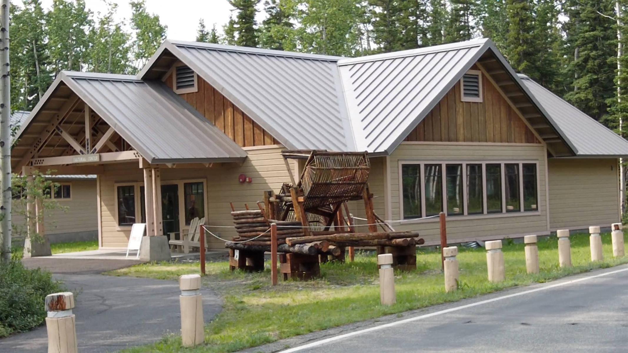
The Ahtna Cultural Center, C'ek'aedi Hwnax 'Legacy House', is located next to the Wrangell-St. Elias Visitor Center and is operated by Ahtna Inc. There are Alaska Native exhibits, a hand-built fish wheel, a food cache and museum staff available to answer questions. Hours of operation vary - call before visiting. (907) 822-5955.
The Ahtna Cultural Center is located about 30 feet (9 m) northwest of the Theater building along the asphalt-paved Visitor Center Complex walkway. A triangular wooden arch with wooden beams, about 20 feet (6 m) high by 20 feet (6 m) across, hangs over a concrete pad entranceway. Moving about 15 feet (4.5 m) across the concrete porch area, a set of double metal and glass doors swing outward across a metal grate. Note a couple wooden Adirondack chairs to the left of the doors. Be mindful of the threshold as you cross from the concrete porch onto a carpeted floor inside the building. About 20 feet (6 m) further along the path past the cultural center building, a full-size Alaska Native wooden fish wheel is displayed outside. The eight-foot (2.5 m) wide apparatus stands about 12 feet (3.5 m) high by 15 feet (4.5 m) long. Set into a flowing river on log floats, two large, opposing, curved, shovel-like baskets are pushed and rotated by the water like an oversized pinwheel, scooping up salmon as they swim upstream. As the basket turns, the captured fish are shunted into a six-foot (2 m) wide by four-foot (1.25 m) deep rectangular holding box attached to the side of the wheel. From a position facing the fish wheel, turn around 180-degrees, and move to the other side of the asphalt path. Directly in front of you, note another wooden structure that appears like a small, windowless log cabin on six-foot (2 m) tall stilts with a small, wood log door on the front. This is a model of a food cache for storing nuts, dried foods, and meat over the winter, protecting it from bears and other wildlife. A full-size food cache would be two- to three-times as tall as the model, with inward slanting legs to deter climbing animals. People would have to use a ladder to climb up to a narrow platform in front of the door to access the cache.
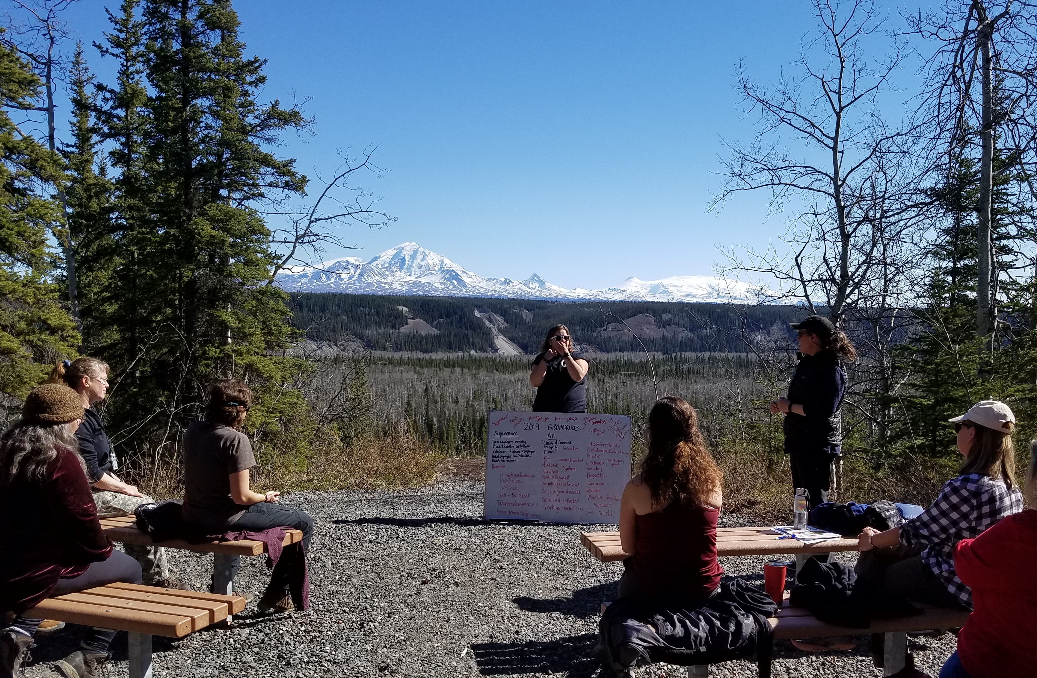
Rangers can present programs overlooking the bluff and view of the Wrangell Mountains (weather permitting) while the audience sits on benches arranged in a small outdoor amphitheater.
About 100 feet (30 m) south along an asphalt path from either the back door of the visitor center or the Mosaic Landscape wayside panel, a four-foot (1.25 m) wide gravel path continues another 50 feet (15 m) south to the park amphitheater. From a vantage point high on the bluff, two rows of four, angled, eight-foot (2.5 m) wide wooden benches face east, looking across the Cooper River valley below to the Wrangell mountains beyond. There’s a roughly 10-foot (2.75 m) square gravel-covered open area at the front of the benches. Note the edge of the bluff falls off abruptly another 15 feet (4.5 m) forward. Throughout the summer season, the amphitheater is used for short educational talks and programs about Wrangell-St. Elias National Park and Preserve, and the Copper Center area. A calendar of scheduled events at the amphitheater can also be obtained at the visitor center.
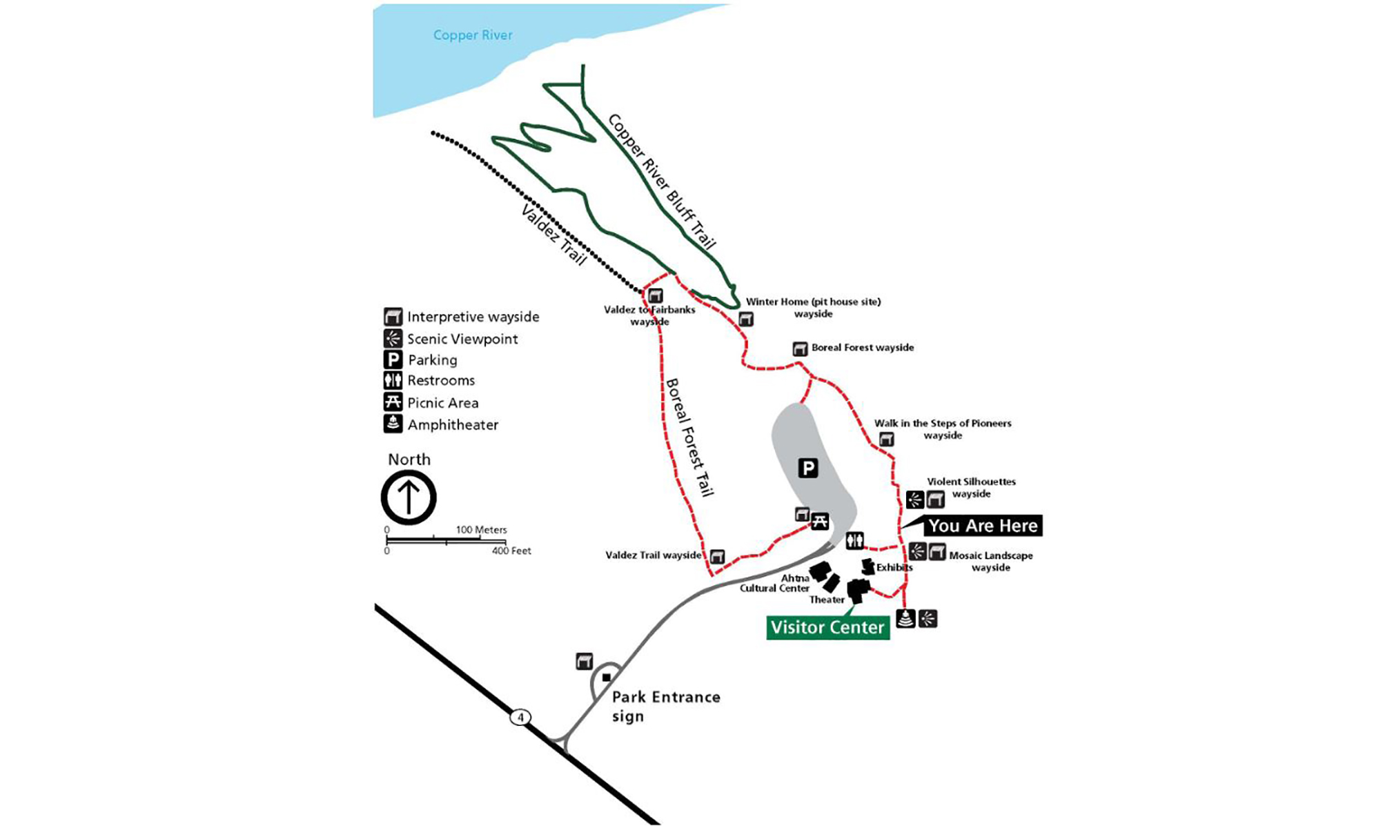
The 1/2-mile loop Boreal Forest Trail follows even terrain, though wheelchair-users may need assistance. The trail passes along the river bluff, then cuts through the forest, connecting to a section of the historic Valdez Trail, the first all-American route into interior Alaska. View interpretive panels along the bluff overlooks and through the forest.
About 150 feet (45 m) north along the asphalt bluff path from the Violent Silhouettes wayside panel and overlook, a color photograph fills an angled, metal wayside panel. Entitled, “Walk in the Steps of Pioneers,” it shows a narrow dirt path winding through the low, mossy underbrush of a forest of spruce trees. Note that about 30 feet (9 m) south of this location, a pair of long-range binoculars, mounted atop a five-foot (1.5 m) metal pole with a concrete base, offers stunning views of the valley and mountains to the east. Note a wooden bench on the opposite side of the path across from these binoculars. Text at the bottom left of the panel provides information about some of the easy hiking trails here at the Wrangell-St. Elias Visitor Center Complex. It reads: The 1/2-mile loop trail follows even terrain, though wheelchair-users may need assistance. The trail passes along the river bluff, then cuts through the forest, connecting to a section of the historic Valdez Trail, the first all-American route into interior Alaska. A transition begins here, though it’s not obvious. But walk a short distance and you’ll see an abruptness that marks the shift from one forest successional stage to the next. Still farther, you’ll walk in the steps of pioneers who brought about great change to this wild land. Please use caution as you travel through bear country. Leave cultural sites, plants, and animals undisturbed, for future generations to enjoy. A green inset map at the lower right shows your current location with a black, “You Are Here” marker, the location of the Visitor Center with a green marker, and the paths of the trails available from this location. The Boreal Forest Trail is indicated with a solid red line, the Valdez Trail with a dotted black line, and the Copper River Bluff Trail with a solid green line. Descriptions of each of the trails at the top right of the map read: The Boreal Forest Trail is a 1/2-mile loop, partly paved, with no elevation change. The Valdez Trail is a short segment of a historic trail, gravel, and easy to walk. The Copper River Bluff Trail is a 1/2-mile loop, gravel, moderately difficult, with some elevation change and a few steep sections. Further north along the trail, a color illustration fills the face of a second, angled metal wayside panel. Entitled, “The Boreal Forest,” it shows a number of the plants, animals, and geologic features of this ecosystem. There’s the small brown and white Swainson’s Thrush, the grey and white speckled Spruce Grouse, the Yellow-rumped Warbler with blue feather and small yellow patches, and the grey, brown, and red Boreal Chickadee. A brown and grey Snowshoe Hare huddles in the underbrush, in front of a large brown moose among the trees at the back. There’s a small wolverine-like creature at the lower left, the Pine Marten, with light to dark brown fur with cream- to yellow-colored "bib" markings on its throat. Pink-flowered Fireweed grows beside Feather Moss, Highbush Cranberry with broad, three-lobed leaves with serrated edges, and a small shrub with clusters of small, white flowers, Labrador Tea. Text at the top left reads: The boreal forest is the northernmost and largest forest ecosystem in the world. Extreme cold and a short growing season are the main environmental factors that shape this forest. In this region, the boreal forest is composed of stands of white and black spruce, aspen, balsam poplar, birch, alder, and willow. A young forest often has more deciduous trees and shrubs. As the forest matures, spruce trees begin to dominate. Over time, the accumulation of spruce needles on the forest floor creates a thick buildup of organic matter, which decomposes slowly. This thick organic layer, in concert with canopy shade, keeps ground temperatures cool, increasing the depth of the permafrost. Permafrost causes poorly drained soils and restricts the growth of deep root systems. Dense shade, thick organic matter, and cold moist soil result in low plant diversity and an often stunted looking forest. Is the forest here young or old? Do you notice the spongy ground with organic debris and mosses? At the left, text next to a drawing of a red squirrel clinging to the side of a tree reads: The red squirrel—the sentinel of the boreal woods—sends scolding alarms throughout the forest, tipping off other animals to intruders. A mat of orange and red scales blankets the forest floor near the squirrel. Text identifies it as a: Red Squirrel Midden Spruce cones scales form middens as red squirrels discard them and eat the extracted seeds. Squirrels cache winter food deep within the middens. A cluster of rust-colored spruce branches in the center is identified as: Spruce Broom Rust Kinnikinnick host the spruce broom rust fungus. Spores released from the fungus living on kinnikinnick enter the spruce tree, causing branch clustering, which provides habitat for squirrels and birds. Text over a cluster of green spruce branches at the right reads
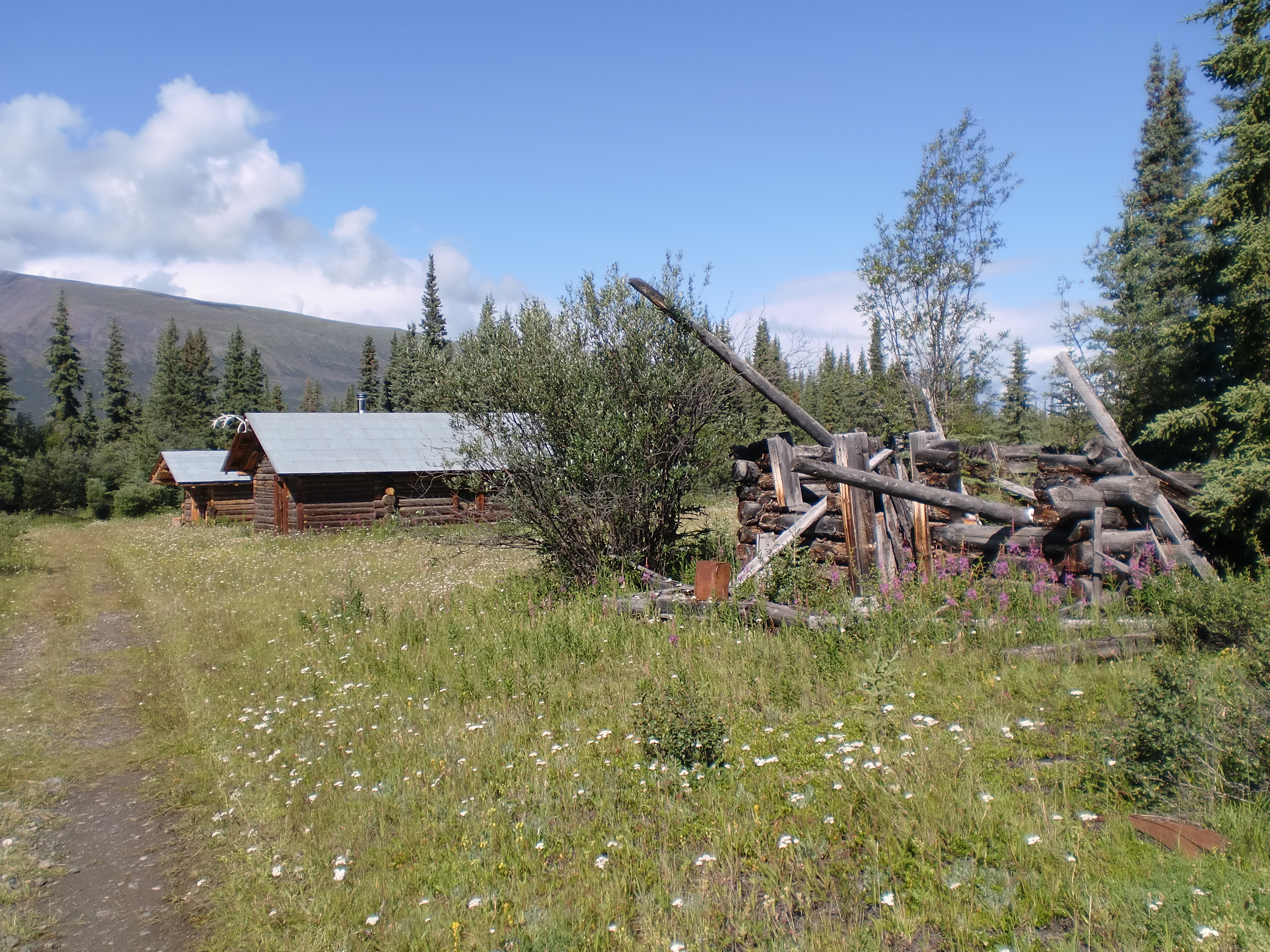
Bremner is a glacier, river and mining camp within Wrangell-St Elias National Park. It is named after John Bremner, who in 1884-1885 was the first non-native person to live in the area and who prospected for gold along the Bremner River. Located just to the north of the Bremner River, it was the scene of an important placer gold discovery in 1902, and played a key role in the history of the Copper River Basin.
An early 1900s cabin in a rugged and remote part of the Wrangell-St. Elias wilderness.
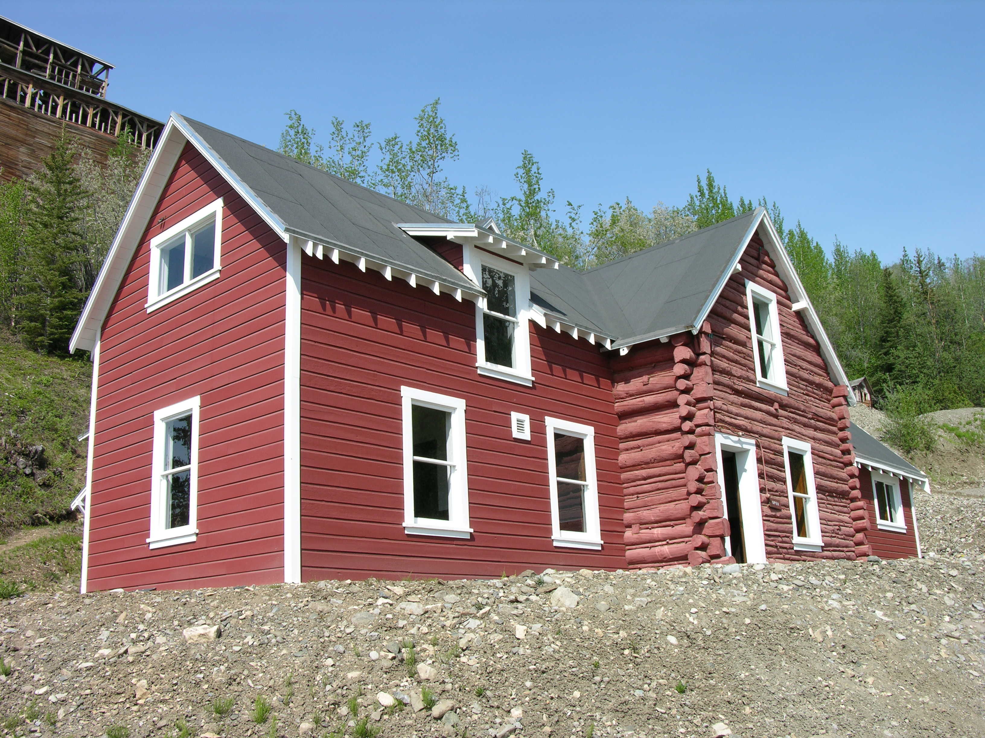
Chisana (pronounced shoo-shana) is a small community inside Wrangell-St Elias National Park and Preserve, only accessible by plane or long snow machine ride in winter. It is located half-way between Nabesna and McCarthy, Alaska.
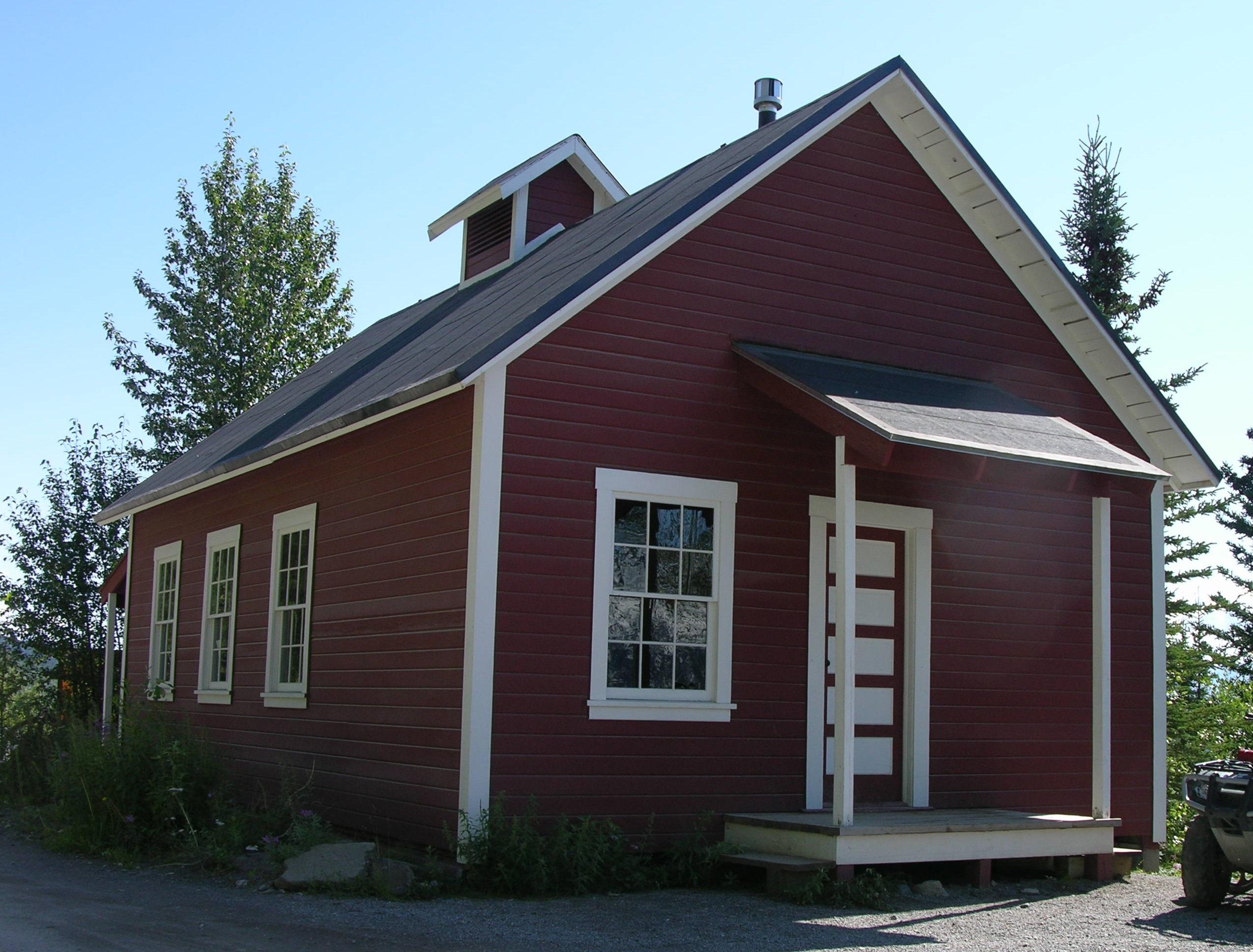
Chisana (pronounced shoo-shana), also known as Shushana, Chathanda City and Johnson City. Listed as Chisana Mining District on the National Register of Historic Places in 1985 and renamed Chisana Historic Mining Landscape in 1998. Nestled in a remote valley between the Nutzotin and Wrangell Mountains, half-way between Nabesna and McCarthy, the Chisana mining district provides visitors with a unique glimpse of Alaska's gold rush era. Unlike many better known and more accessible regions, this area retains extensive evidence of its early mining use, including the deteriorating remains of two towns; numerous tent camps, various water diversion and delivery systems; a full range of hand, hydraulic, and mechanical mining operations; and a well-developed transportation network. The scene of Alaska’s last important gold rush in 1913, the Chisana district played a key role in the history of interior Alaska. While few struck it rich, the resulting demand for materials and supplies helped establish regional transportation networks, encouraged supporting industries, and hastened the exploration and settlement of both the Copper and Tanana Basins. The Chisana district was particularly significant from 1913 to 1915, the period encompassing its discovery, stampede, and boom. Chisana became known as "the largest log cabin town in the world." It remained important through 1942, when war-time exigencies virtually ended local mining. Today, Chisana enjoys a seasonal population of about twenty-five. A few persistent placer miners continue to work the district's creeks. The spiritual heirs of the stampeders, they continue their predecessor's quest, ever searching for that one rich strike. There are bed and breakfasts and guide/outfitters in this area that is accessible only by small aircraft. Some adventurous hikers retrace the steps of the early stampeders and make the trek from Chisana to McCarthy. This is a difficult route and should only be attempted by experienced backcountry travelers or with an outfitter guide.. As you hike around Chisana you will see ruins of structures and historic artifacts throughout the area. For its protection and to keep its historical integrity, it is unlawful and prohibited to remove or relocate anything. Debris and artifacts provide important clues to the story of the people who followed the lure of gold to Chisana. Many of the historic structures are located on private property. Public easements are marked, so please respect private property while at the site. The National Park Service has restored four log buildings in the original townsite, the Woman's Jail and three residential cabins. The primative Too Much Johnson Cabin is available for public use on a first-come, first-served basis.
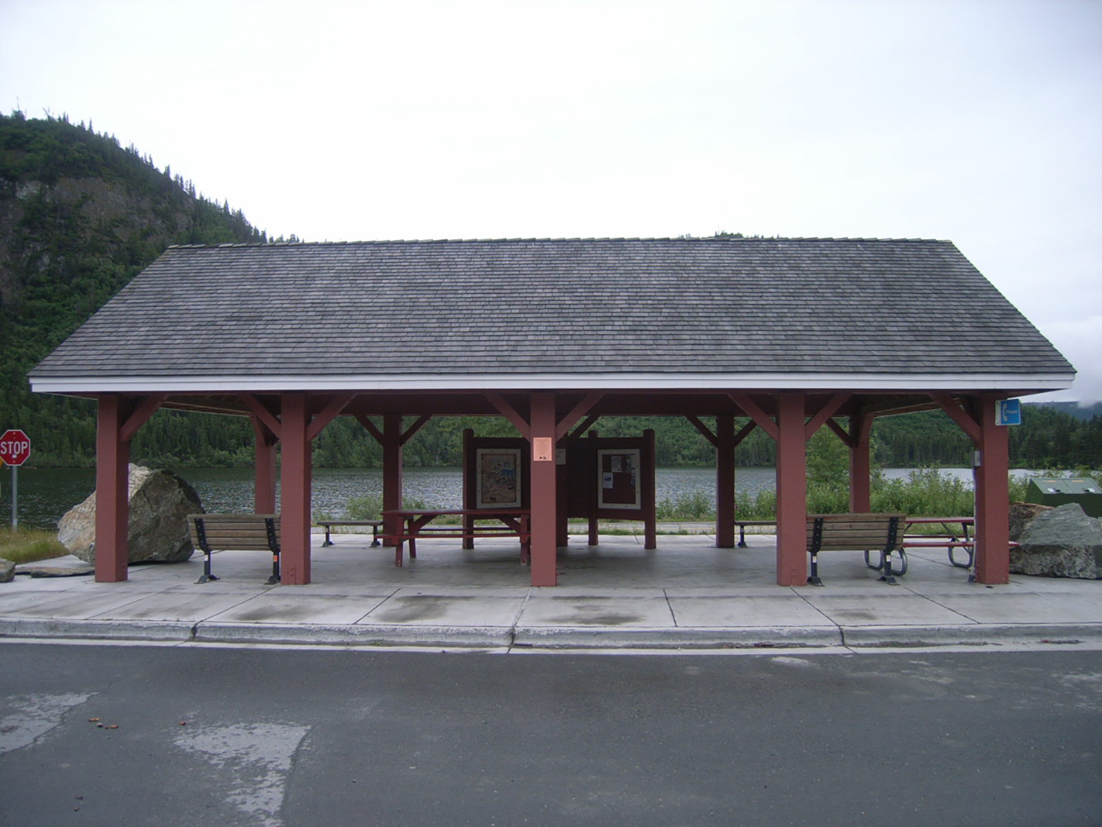
Pronounced "Chit-nah," this railroad town sprang to life in 1910 and was once a bustling stopover between Cordova and Kennecott. It is still busy during fishing season. Here at this wayside are restrooms and informational panels. Gas but not diesel is available 24 hours in town.<br />
Chitina Wayside. 1 ¼ minutes.<br />Next to a small paved parking lot, the 35-foot (10 m) long by 15 foot (4.5 m) wide Chitina Wayside is a one-story, open pavilion and shelter with a concrete floor, and four thick, dark red brown support posts along each side. Several benches and picnic tables share the open space inside. Along one side of the wayside at the center, note a set of three general information panels about the Ahtna people and history of Chitina itself.<br />Note one, six-foot (2 m) tall boulder on the sidewalk at one end of the wayside, with three smaller boulders at the opposite side end the shelter, next to the van accessible area of the parking lot. Wheelchair ramps from the parking lot up onto the sidewalk are located at either end of the pavilion.<br />Note a small wooden red and white vault restroom building located at the far end of the parking lot, about 130 feet (40 m) along the sidewalk leading away from the shelter. The women's room is on the left, and the men's room is on the right. Both facilities are wheelchair accessible.<br /><br />
The Copper River is the largest river in the park. At 290 miles long, the Copper River begins at the Copper Glacier on the northeast side of Mount Wrangell, in the Wrangell Mountains. It first flows north, then west and then south where it forms the park’s western boundary. As it flows further southeast through the Chugach National Forest, it eventually empties into the ocean in the Gulf of Alaska near Cordova. The Lat/Long. is represented at Copper Center, Alaska.
The Copper River is the largest river in the park. At 290 miles long, the Copper River begins at the Copper Glacier on the northeast side of Mount Wrangell, in the Wrangell Mountains. It first flows north, then west and then south where it forms the park’s western boundary. As it flows further southeast through the Chugach National Forest, it eventually empties into the ocean in the Gulf of Alaska near Cordova. As an enormous Alaskan watershed, it is known for its extensive delta ecosystem. The Copper is the tenth largest river in the United States, as ranked by average discharge volume at its ocean mouth, USGS publication. The river's famous salmon runs arise from the use of the river watershed by over 2 million salmon each year for spawning. The river's commercial salmon season is very brief, beginning in May for chinook salmon and sockeye salmon for periods lasting days or hours at a time. Sport fishing by contrast is open all year long, but peak season on the Copper River lasts from August to September when the coho salmon runs. Subsistence fishing (cultural and traditional uses of the land and water) is predominately done with dipnet or fishwheel, with special use permits for local rural residents. Glacial rivers carry an extremely high level of silt, typically making it impossible to see the river bottom. Spring run-off, heavy rain, and hot summer temperatures can cause quick, dramatic change in water levels. Year round, The Copper River is extremely cold and hypothermia is a danger even after a brief submersion, regardless of air temperature. Always wear a drysuit and a personal floatation device (pfd) while floating or boating. https://www.nps.gov/wrst/planyourvisit/river-floating-and-boating.htm It's cultural and traditional name is Ahtna River, in Ahtna Athabascan - ‘Atna’tuu, "river of the Ahtnas", and in coastal Tlingit - Eeḵhéeni, "river of copper". The name of the river comes from the abundant copper deposits along the upper river that were used by Alaska Native communities and then later by settlers from the Russian Empire and explorers from the United States.
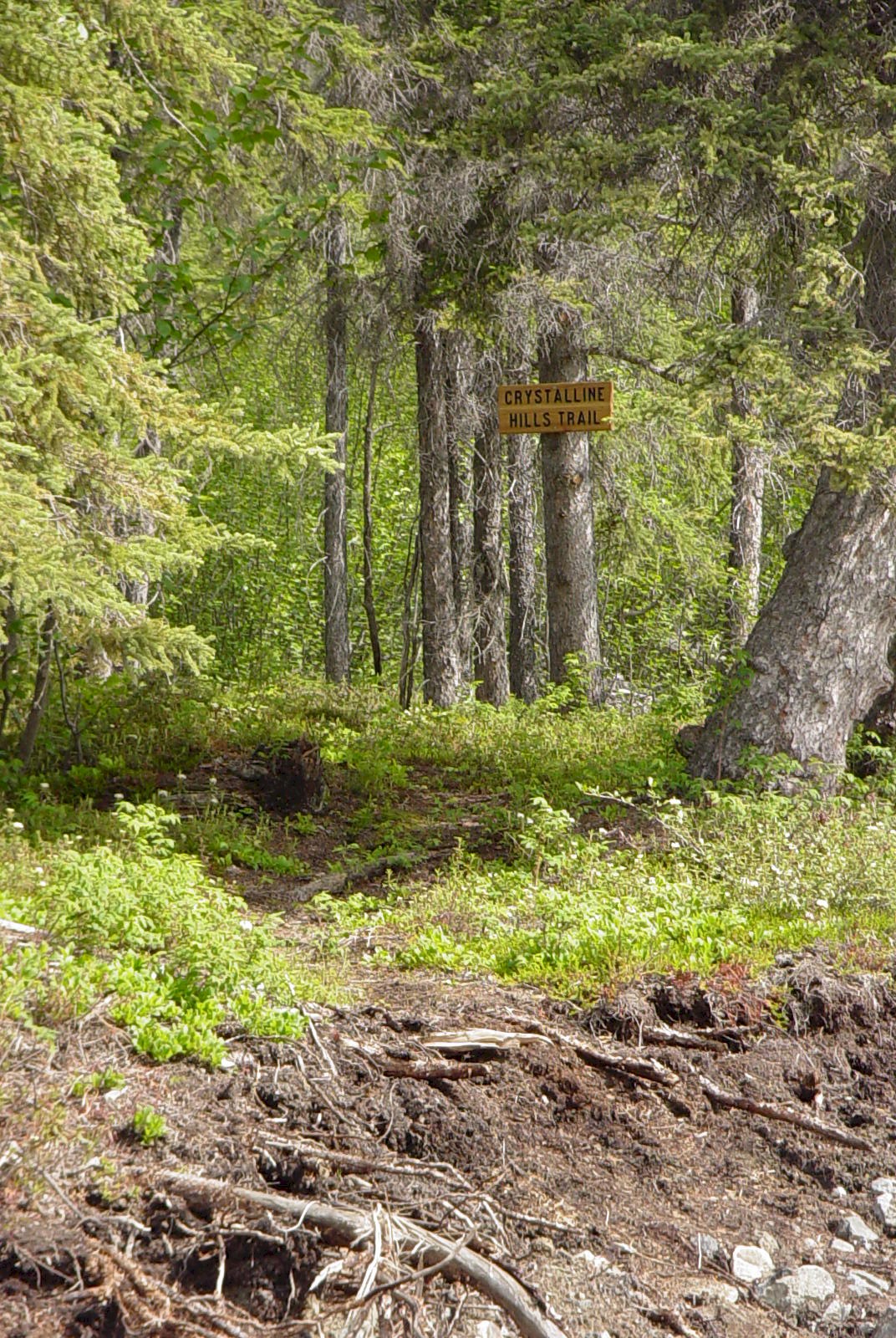
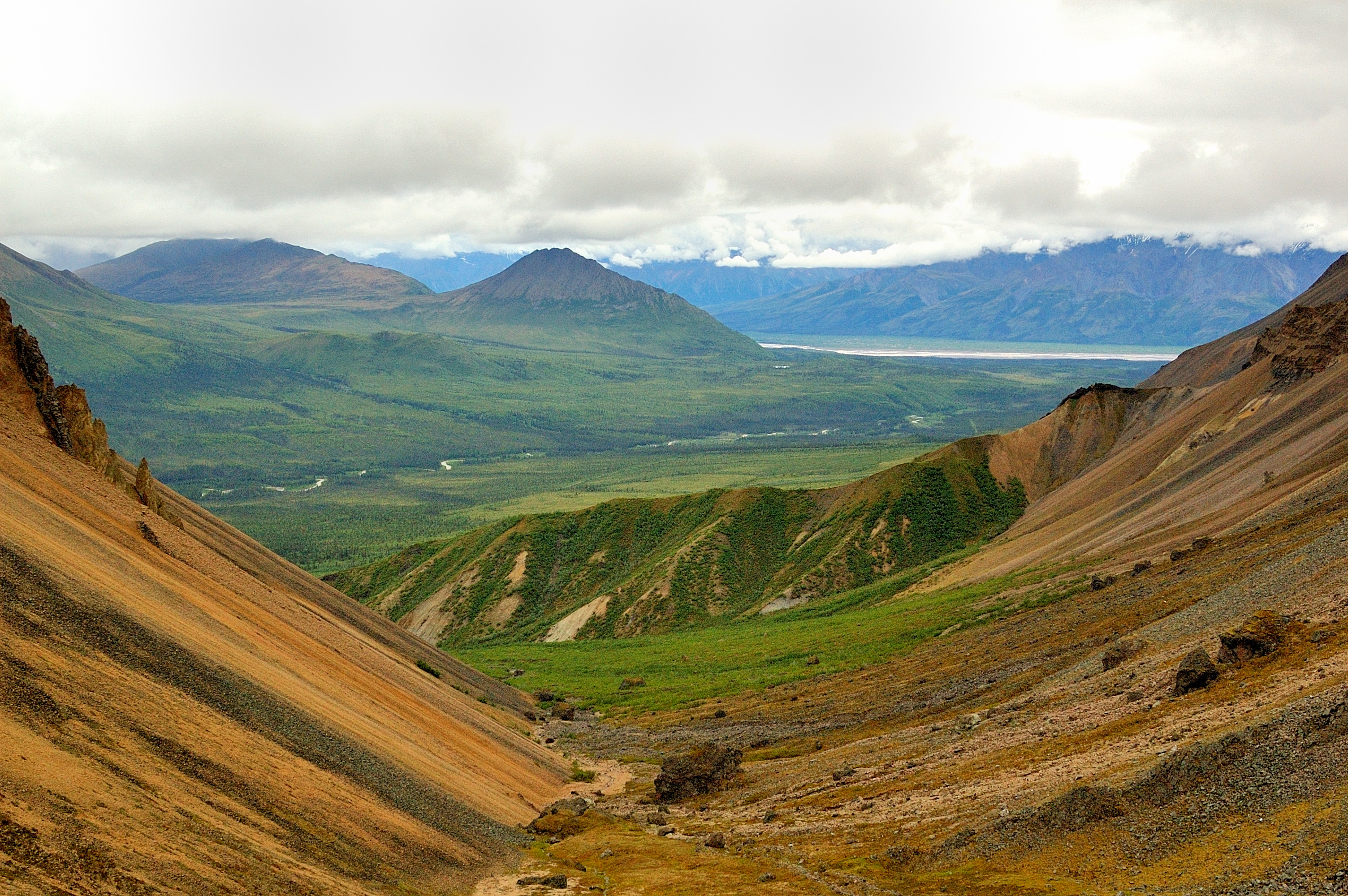
The Crystalline Hills north of McCarthy Road are composed mostly of gneiss and gabbro, but some of the lower slopes are made up of a light colored marble. These hills are an excellent place to see Dall Sheep up on the hills and hike up to nice scenic views.
Access: Trailhead along McCarthy Road, Mile 34.8 Distance: 2.5 mile loop Time: 2-3 hours Maps: McCarthy 1:63,360 (B-7) Difficulty: Moderate. Highlights: Road access, beautiful views. Route: The trailhead is located along the north side of the McCarthy Road at mile 34.8. Look closely for the wooden sign. After 1/2 mile, a short side trail leads to a nice view. The main trail continues to climb gradually through the dense forest and loops back along the base of the steep Crystalline Hills. Pick a place to scramble up for outstanding views of the Chitina River valley, Moose Lake, and the Chugach Mountains. Adventurous hikers can continue to climb higher into the Crystalline Hills for remote camping and exploring the many high ridges and rocky ledges. Notes: The trail passes through shady forest and bug spray is highly recommended in summer. The best views are achieved by scrambling up the steep slopes of the Crystalline Hills.
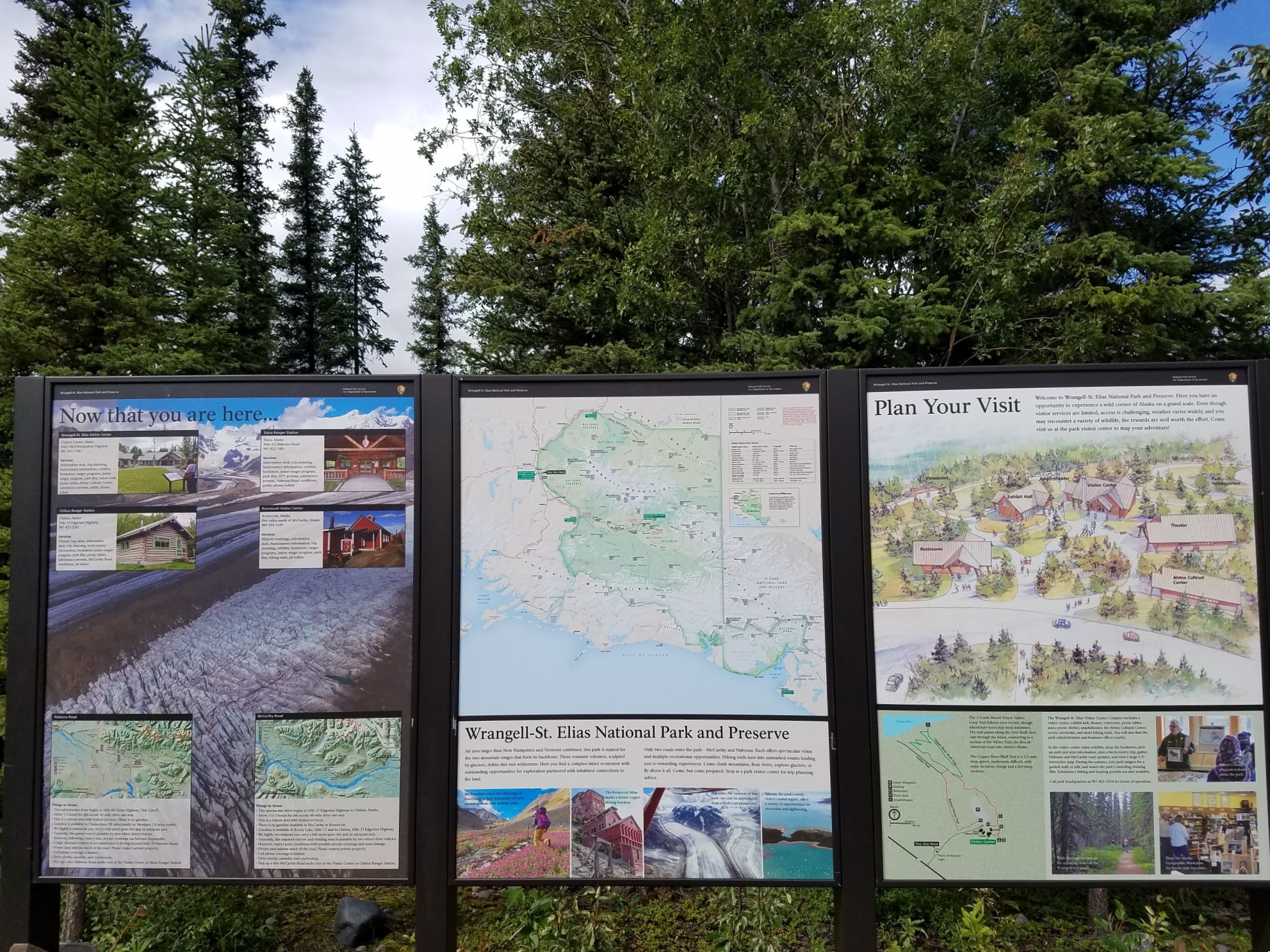
The Wrangell-St. Elias Entrance Loop Information Sign is located at the north end of the Headquarters driveway entrance loop, off the Richardson Hwy at mile 106.8 near Copper Center. There are three panels which include the park map, visitor center and ranger station locations, scenic images, map of the visitor center complex and map of the Bluff Overlook - Boreal Forest Trail.
The Wrangell-St. Elias Entrance Loop Information Sign is located at the north end of the Headquarters driveway entrance loop, off the Richardson Hwy at mile 106.8 near Copper Center. There are three panels which include the park map, visitor center and ranger station locations, scenic images, map of the visitor center complex and map of the Bluff Overlook - Boreal Forest Trail.
On this self-guided tour of the Exhibit Hall, view interpretive exhibits to learn about natural and cultural resources of the area, including gold and copper miners, bush pilots, explorers, Alaska Natives, volcanoes, glaciers and wildlife.
The one-story wood frame Exhibit Hall building is located about 30 feet (9 m) east from the flag pole outside the visitor center across a small asphalt courtyard. A triangular, 20-foot (6 m) high by 20-foot wide wooden arch with wooden beams hangs over a concrete pad entranceway. Note a couple benches at the left and right. A set of double metal and glass doors swing outward across a metal grate. Be mindful of the threshold as you cross from the concrete porch onto a stone floor inside the building. Inside, follow along a winding, simulated riverbed path. Exhibits describe the geology and formation of the landscape, and how rivers carve their way through the rocky terrain and old lake-bed sediments, reducing it to a silty dust suspended in the water. Other exhibits discuss the different wildlife in the park, some of the history of the Kennecott Mines, information about the native Ahtna peoples, and other people in the region, including explorers, prospectors, and a back-country pilot.
The GMO housed the heart of the Kennecott Copper Corporation: its management. Here are the offices of the superintendent, manager, engineers, secretary and draftsmen.<br />
"General Manager's Office. 37 ½ minutes.<br />The General Manager's Office is located up a moderately steep, switchback gravel path to the east from the main gravel road, just north of the wood plank bridge over National Creek. A flagpole sits outside the building at the left.<br />The central log portion of the red and white, two-story building is the oldest building in Kennecott. Later additions at the left and right provided more office, safe, payroll, and drafting space. <br />This 2,451 square foot (745 square meter) building was the hub of corporate activity in the 1920s and 1930s. There are numerous exhibits inside this self-guided facility, providing access to historic and interpretive documents about Kennecott Copper Corporation, biographical information on corporate leaders, reproductions of mining maps, photos, surveys, engineering reports, employment records, and drawings of buildings and machinery. <br />"<br />
The company store sold just about anything you needed. If it didn't, you could order items through the Sears and Roebuck catalog and they would be delivered to the post office. The warehouse stored grocery items but most importantly, the nuts, bolts and spare parts needed in the mill and mines.<br />
"General Store, Exhibit Center, Warehouse, Storeroom, and Post Office. 87 ½ minutes.<br />The General Store, Exhibit Center, Warehouse, Storeroom, and Post Office are all located in the three-story red and white wood building on the west side of the main gravel road, just north of the intersection of the inclined, gravel service road. <br />Facing the building, a five-foot (1.5 m) wide wood plank boardwalk spans the front of the 35-foot (10 m) wide storefront. Two sets of bay windows at the right flank a recessed wood and glass door leading into the General Store. About six feet to the left of the left-hand bay window, a single wood door leads into the Post Office, flanked by two white double-hung windows.<br />Note a wooden bench along the boardwalk under the window to the left of the bay.<br />You may enter the General Store or Warehouse from four different locations. Either: 1) through the front door of the General Store, the main entrance; 2) at the far right, through a side door on the north side of the building, from a 40-foot (12 m) long by four-foot (1.25 m) wide wheelchair accessible catwalk; 3) through the Post Office door immediately to the left; or 4) at the far left, up a short flight of four stairs to an open, 10-foot (2.75 m) square wooden platform with a couple wooden benches, then right 40 feet (12 m) down a slightly inclined ramp with wooden railings through a set of double wood doors on the south side of the building. <br /><br />To enter the Post Office, move through the single door located towards the left-hand side of the storefront. Once inside, move five feet left (1.5 m) on a 45-degree angle to a narrow, open wooden doorway. Just to the right of the door is a small, chest high open counter window. Several letters and stamps are displayed on the counter under glass. <br />To the right of the counter, rows of wooden mail boxes line the wall, some with historic brass fronts with small glass windows and combination locks. The original Kennecott post office sign hangs above the boxes, a four-foot (1.5 m) wide black sign with white block letters reading, "U.S. Post Office, Kennecott, Alaska." Note a reproduction hangs in the original location, directly above the door outside. <br />To the left of the door is a floor-standing information panel. Text at the top of the panel reads:<br /><br />Post Office<br />Built in 1917, restoration completed in 2006<br />Keeping in touch with home<br />The vast majority of Kennecott workers were far from home and family, so the Post Office was an important link to their loved ones. Workers sent letters and money orders-after all, they were here to make and save money. They also received news and mail-order goods. Mail traveled by train and, in later years, by air. Some long-term staff had brass mailboxes here, but most letters were sent to their recipients via general delivery.<br />To send news or to wire money home more quickly -and at greater expense-workers went to the Wells Fargo telegraph service in the Railway Depot.<br /><br />A black-and-white photograph, entitled "Snowbird at the post office, 1937," fills the bottom of the panel. It shows a woman standing outside in front of the snowy and ice-covered Post Office next to a modified automobile with caterpillar tracks in the rear and skis in the front. <br />Move through the door to enter the back room of the Post Office. The open backs of the letter boxes line the wall to your right. Opposite the boxes, a mail duffel bag artifact hangs on the back wall at the left.<br />Another single wooden door at the back left of the Post Office leads into the Storeroom, though it is highly recommended you move back outside through the front door of the Post Office to continue your tour, beginning in the Store.<br /><br />Note that beacons inside each of the remaining three entrances will automatically trigger the appropriate interior audio description for your location. <br />"<br />
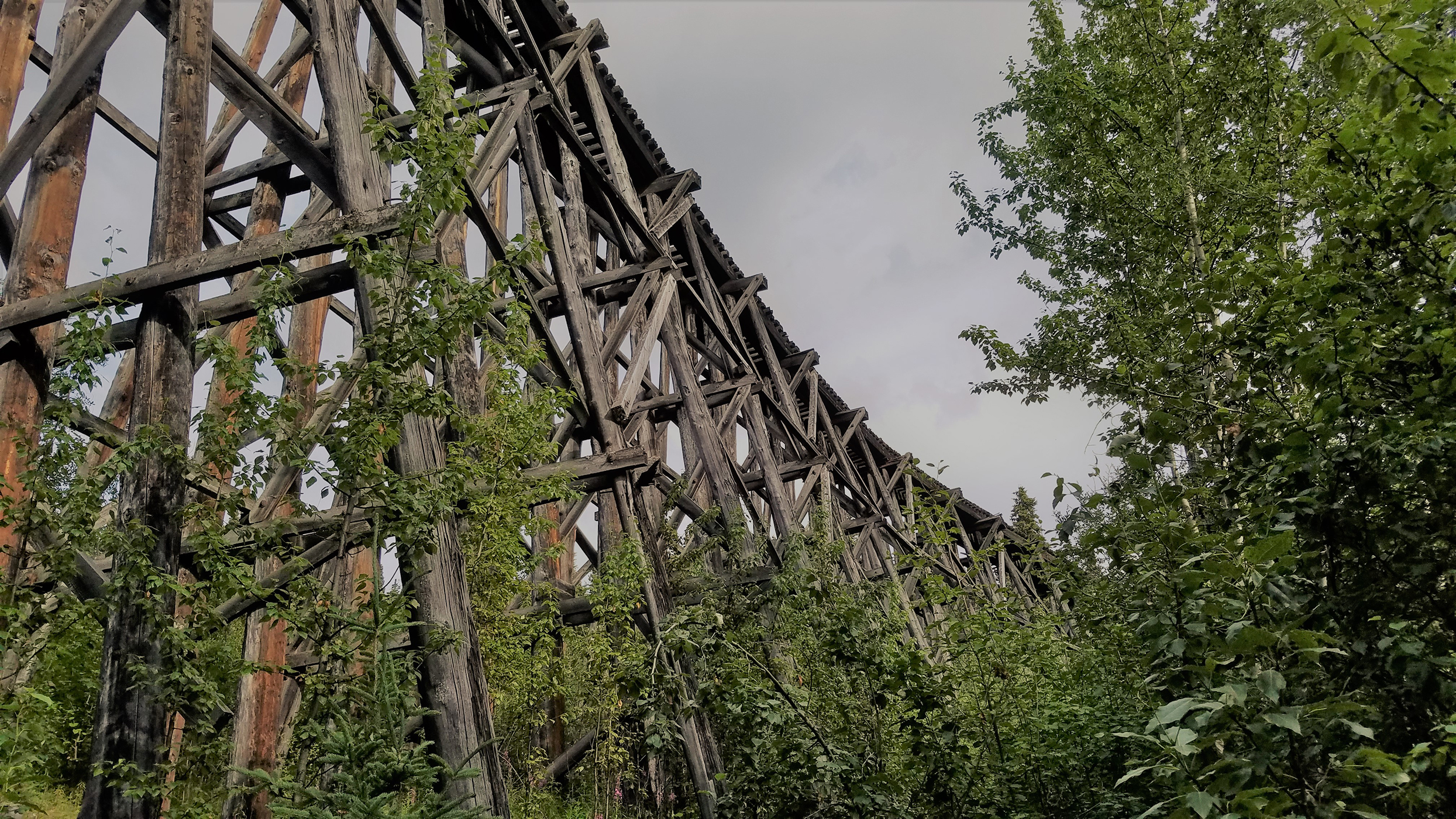
This wooden structure was originally 890 feet long and 90 feet high, required one-half million board feet of timber, and was completed in eight days in January of 1911. There are vault toilets and a 1/2 mile trail here that leads south from the toilets.<br />
Gilahina Railroad Trestle. 4 ½ minutes.<br />About halfway between Chitina and McCarthy, a small National Park Service (NPS) gravel parking lot and pullout area sits on the Chitina side of a one-lane bridge over the small Gilahina River.<br />With concrete reinforced planks and guardrails on either side of the 35-foot (10 m) long bridge, it is safe to cross by vehicle, on foot, or using a wheelchair. <br />Be mindful of traffic as there is no separate sidewalk, and the road deck drops off immediately underneath the guardrail into the rushing river below. <br />Facing upstream from a vantage point in the middle of the bridge, an abandoned, curved timber stringer bridge stands 90 feet (28 m) high and not quite 880 feet (268 m) across, almost spanning the heavily forested valley from left to right. Tall, wooden elevation trusses lean under the fractured, crumbling, and splintered railroad bed high overhead.<br />It may be a worthy experience simply to dip your hand in the chilly water, fed from the mountains up above. <br />Back in the parking lot, note a small, one-story red and white outhouse at the right. The women's room is to the left, the men's room to the right. Both are wheelchair accessible, but note the gravel lot continues right up to the doorway of the building, with a small concrete lip threshold.<br />A set of bear-safe garbage cans are available about 15 feet (3 m) to the left of the restrooms, next to a couple picnic tables in a small grove of trees at the back of the lot, away from the road.<br />An eight-foot (2.5 m) wide by 10-foot (2.75 m) tall wooden information kiosk to the left of the picnic area displays some interpretive panels on the history of the Gilahina Trestle along with some photographs. <br />At the left, a black-and-white photograph fills the top of the first of two panels. Entitled "Railway to Riches," a steam locomotive pulls a line of freight cars along a narrow railroad bed cut into a steep mountainside. Text underneath the photograph reads:<br /><br />From 1911-1938 the Copper River & Northwestern Railway was the lifeline for the Kennecott mines. Nicknamed the "Can't Run & Never Will" by its skeptics, the CR&NW overcame incredible challenges in its construction and operation.<br /><br />A map across the center shows the route of the railway from Kennecott, across the Kuskulana Bridge into Chitina, and ultimately to Cordova on the Gulf of Alaska. Text tells how the railway blasted and carved through the wilderness, and negotiated massive cliffs, raging rivers, frozen ground, and even icebergs to haul ore to market, and supplies to the mines. <br />A line of smaller black-and-white photographs along the bottom of the panel shows dangerous rock work, a train buried in snow drifts, laying track, steam shovel work, the Kennicott Trestle washing out and men blasting through rock at Woods Canyon.<br />A black-and-white photograph of a train crossing the Gilahina Trestle fills the top of the second information panel at the right. Entitled "Wooden Wonder," this panel tells the story of the amazing and perilous construction of the 90 foot (28 m) tall and 880 foot (268 m) long wooden railroad trestle across Gilahina River. It was constructed in the dead of winter in 1911, in temperatures as low as minus 67 degrees Fahrenheit (minus 55 degrees Celsius). In spite of the terrible conditions, the Gilahina Trestle was completed in just eight days!<br />A black-and-white picture in the center shows the long, sweeping curve of the trestle above a snowy, tree-filled valley. A caption below another picture of the cross-hatched wooden trestle at the right reads in part:<br /><br />Sparks from passing trains were a serious risk to wooden trestles. Water barrels placed along the tracks were used for putting out small fires.<br /><br />A line of smaller black-and-white photographs along the bottom of this panel show makeshift wooden houses in a construction camp at Strelna, a line of pack horses hauling supplies, a railroad track cache, thousands of full ore bags in Kennecott waiting for the railroad to be finished, a view of the half-finished trestle at Gilahina and a railcar crossing the finished Gillahina Trestle. <br /><br />
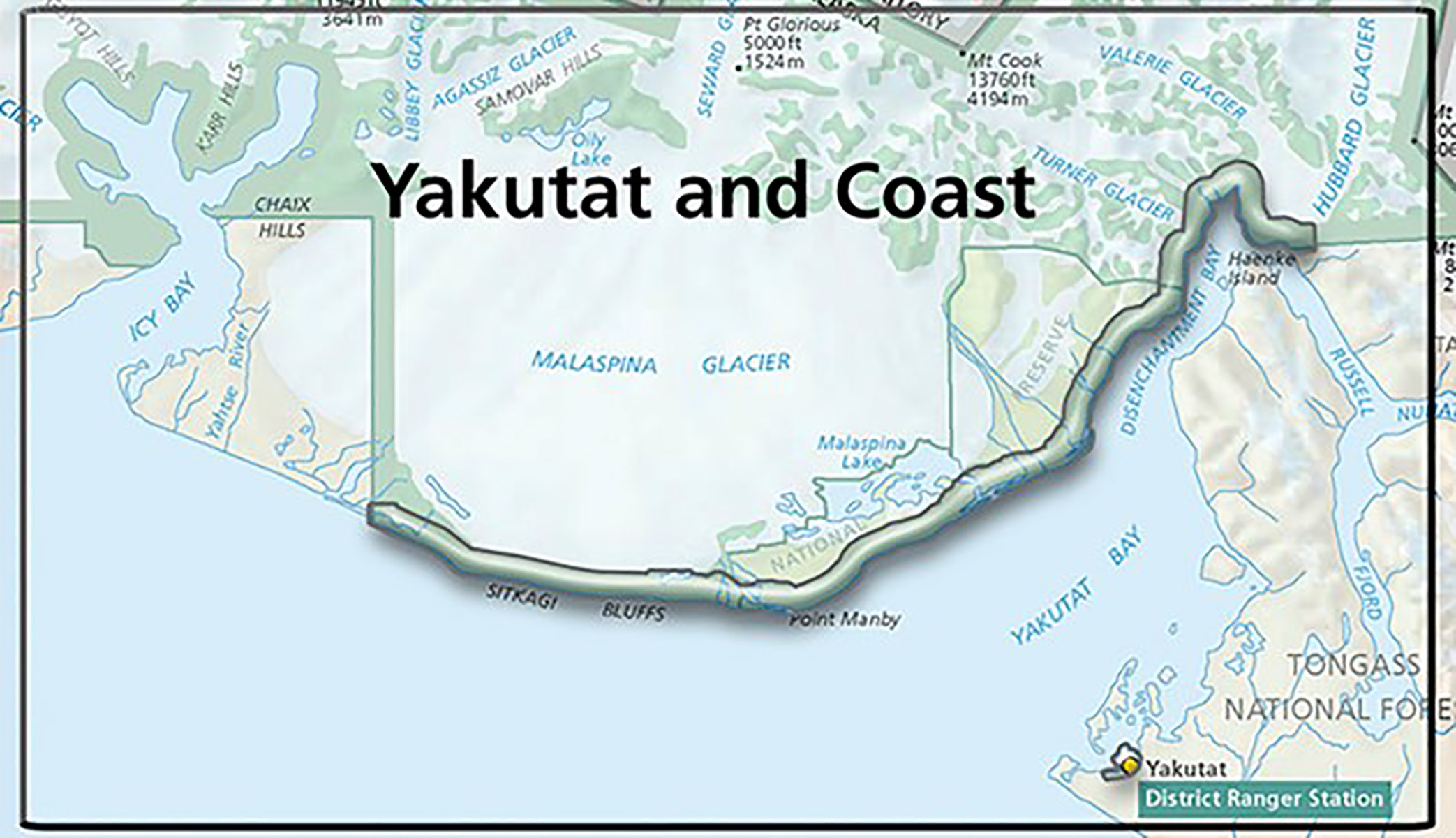
Icy Bay is along the coast in Wrangell-St Elias National Park and Preserve, part of the 155 miles of coastline in the park. The bay was formed in the last 100 years by the rapid retreat of the Guyot, Yahtse, and Tyndall Glaciers.
Icy Bay is along the coast in Wrangell-St Elias National Park and Preserve, part of the 155 miles of coastline in the park. The bay was formed in the last 100 years by the rapid retreat of the Guyot, Yahtse, and Tyndall Glaciers.
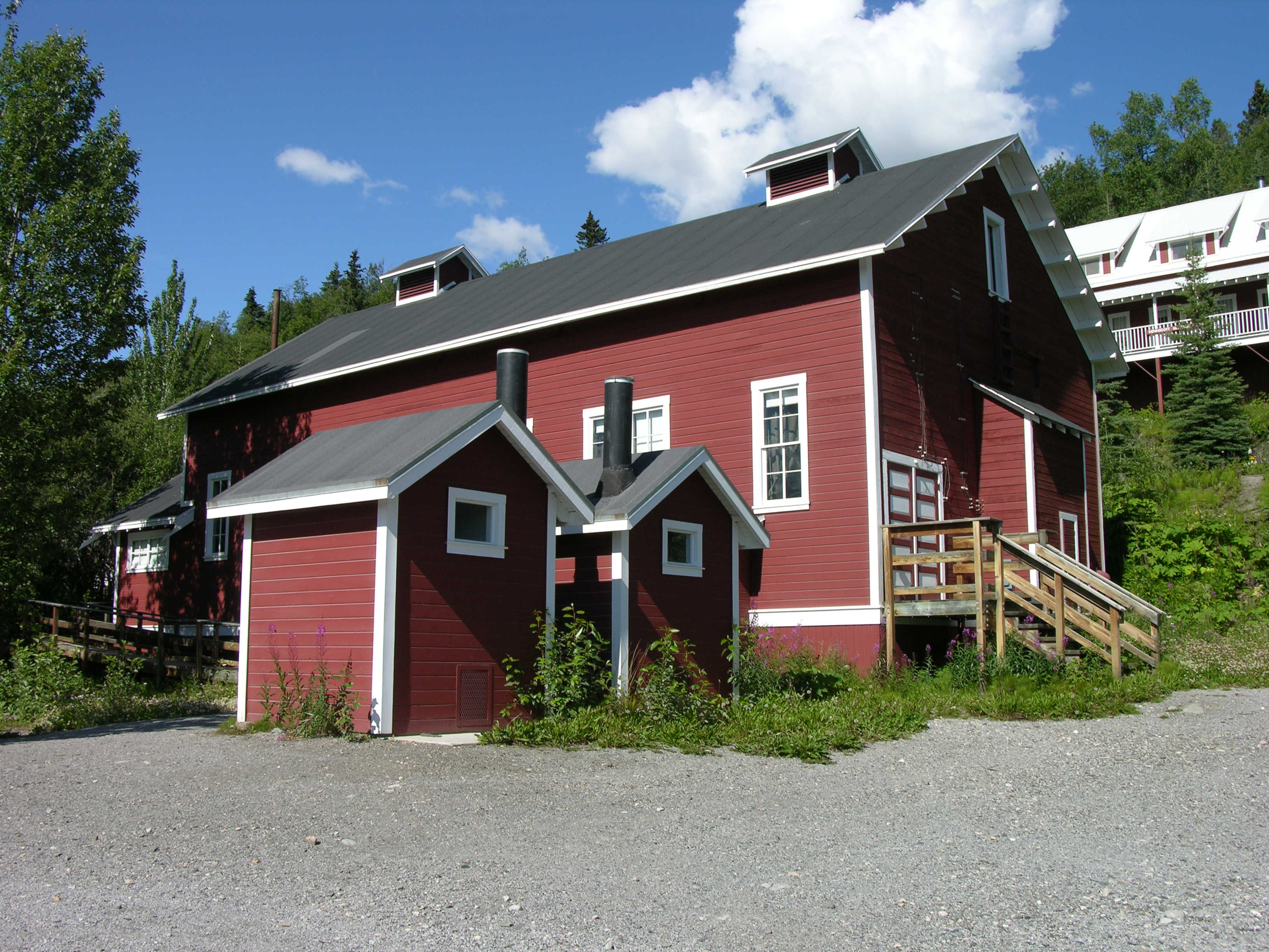
A vestige of an early 20th-century copper mining camp, Kennecott represents the mining techniques of the era. The mines here were among the nation's largest and contained the last of the great high-grade copper ore deposits of the American West.
The Kennecott Mines National Historic Landmark is in the heart of Wrangell-St. Elias National Park and Preserve, America’s largest national park encompassing 13.2 million acres. Even by Alaskan standards, the site is remote, accessed by small plane or the infamous McCarthy Road. The Kennecott Mill Town, the center of the Landmark, is linear in plan, an orientation dictated by the glaciated, mountainous terrain and the railway that served the site. Designated a National Historic Landmark in 1986, the preservation efforts underway by the NPS since 1998 have uncovered an illustrious history and logistical challenges. Following the initial “discovery” of the ore in 1900, the development of the site took considerable effort not to mention financial commitment. Accessing the remote site required the construction of a 196-mile railroad from Cordova at a cost of $25 million. It included 44 miles of bridges and trestles, many of which were wiped out each spring and had to be rebuilt. The mill town and mine camps included over seventy-six buildings ranging in size from outhouses to the 14-story timber frame mill building. The fist sized chunks of ore were mined from seventy-seven miles of underground tunnels and transported to the mill building along three aerial tramways, totaling 6 miles in length. By April 1911, the first trainload of copper ore was headed to Cordova on its way to Tacoma for smelting. At its peak, Kennecott employed 500 to 600 men on three 8-hour shifts. By the time the operation closed in 1938, the Kennecott mines extracted 591,535 short tons of copper from 4,525,909 tons of ore valued at $200,000,000 in 1938 dollars. Exploitation of natural resources has formed the basis for Alaska's economy since Russian fur traders arrived more than 200 years ago. The mining of mineral resources has left an enduring mark on Alaska's landscape.
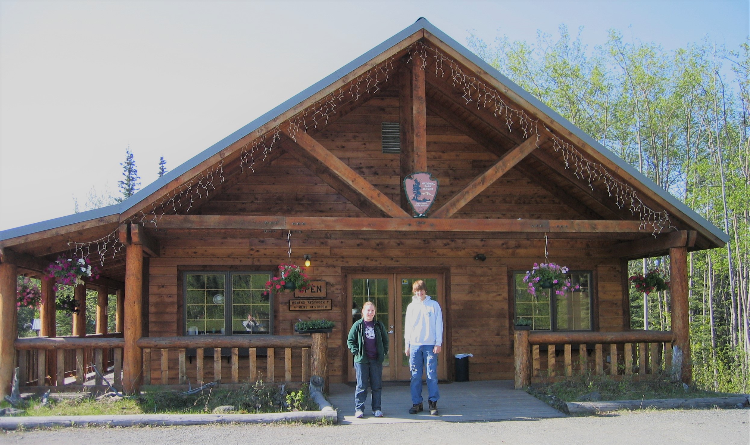
Located in a historic building, this visitor center has ranger programs, maps, exhibits, an information desk, backcountry trip planning assistance, a bookstore, and a restroom. Get your bear cannisters for backcountry travel here.<br />
"Blackburn School Visitor Center. 3 ¾ minutes.<br />The one-story, red and white painted wood Blackburn School is the first building at the far southern end of the town at Kennecott. <br />Note a wheelchair accessible ramp to the north of a 16-foot (5 m) wide wooden deck outside the west side of the building, ringed with a three and a half-foot (1.1 m) tall wooden railing, and an ADA accessible outhouse down a short ramp to the south. Note this same ramp also continues south, linking the visitor center to the shuttle bus turnaround.<br />A three-foot (1 m) tall, cast bronze, tactile, topographical model of the town sits in the middle of the deck. Measuring about five feet (1.25 m) wide by three-feet (1 m) deep, feel the locations of all the buildings and surrounding topography of the town. <br />A visual map of the town just below the touchable exhibit show the various buildings in different shades of red, orange, yellow, white, and gray. These indicate which are National Park Service structures versus private property, and which structures are open to the public. Text at the left of the map reads:<br /><br />Explore Kennecott Mill Town<br />A remarkable lode of copper ore near this very spot was discovered by American prospectors in 1900. Workers then developed the camp, mill, mines, and railway over the next decade. Kennecott Mines went into regular production in 1911, and proved hugely profitable. The mines were tapped out and closed in 1938.<br />Today, Kennecott mill town is the best preserved example of early 20th century copper mining technology in the country. It is also a thriving community and a gateway to an immense wilderness.<br /><br />Behind and to the right of the outdoor model, a single wood door leads inside the school from the outside deck. <br />Inside at the left, a black-and-white photograph fills the bottom of a four-foot (1.25 m) tall by three-foot (1 m) wide angled metal display panel on the floor. A woman in the center, dressed in a long sleeve white, high-collar shirt and floor-length black skirt, stands behind a couple rows of boys and girls of various ages, from six years old to teenagers. Information at the top of the panel tells us that the Blackburn School was built in 1913, moved to Kennecott circa 1915, and restored between 2002 and 2005. Beside a copy of a hand-written inventory of supplies and books at the school, text continues:<br /><br />Moving with the boom and bust of mining towns<br />In 1913, the Kennecott Copper Corporation supplied materials to construct this building in the tiny community of Blackburn. Located along the railway between Kennecott and the future town of McCarthy, Blackburn had grown up as prospectors moved into the valley.<br />By 1915, however, Blackburn was mostly empty-its spring dried up and everyone moved to McCarthy, which was booming as a stop-over on the way to the Chisana gold fields. Kennecott was also booming, so the Corporation moved this building up to its present location on a flatcar. It served as a school for workers' children until the end of the 1921-1922 school year, when the student population had grown again and classes moved to the new and larger Two Room School. The Old School was converted to storage.<br /><br />Inside the School, staff and additional exhibits answer questions about the backcountry, front country trails, and the landmark, and more maps, books, and gifts are available for sale in the Alaska Geographic bookstore.<br />"<br />
One of two bridges, which provides access to McCarthy town and Kennecott Mines National Historic Landmark. All visitors must park their vehicles at the end of the road and walk, bike, or take a shuttle into McCarthy and Kennecott. A seasonal private (non-NPS) shuttle to McCarthy (1/2 mile) and to Kennecott (5 miles) is available on the east side of the bridge. Summer hours of shuttle operation are posted in the weather shelter.
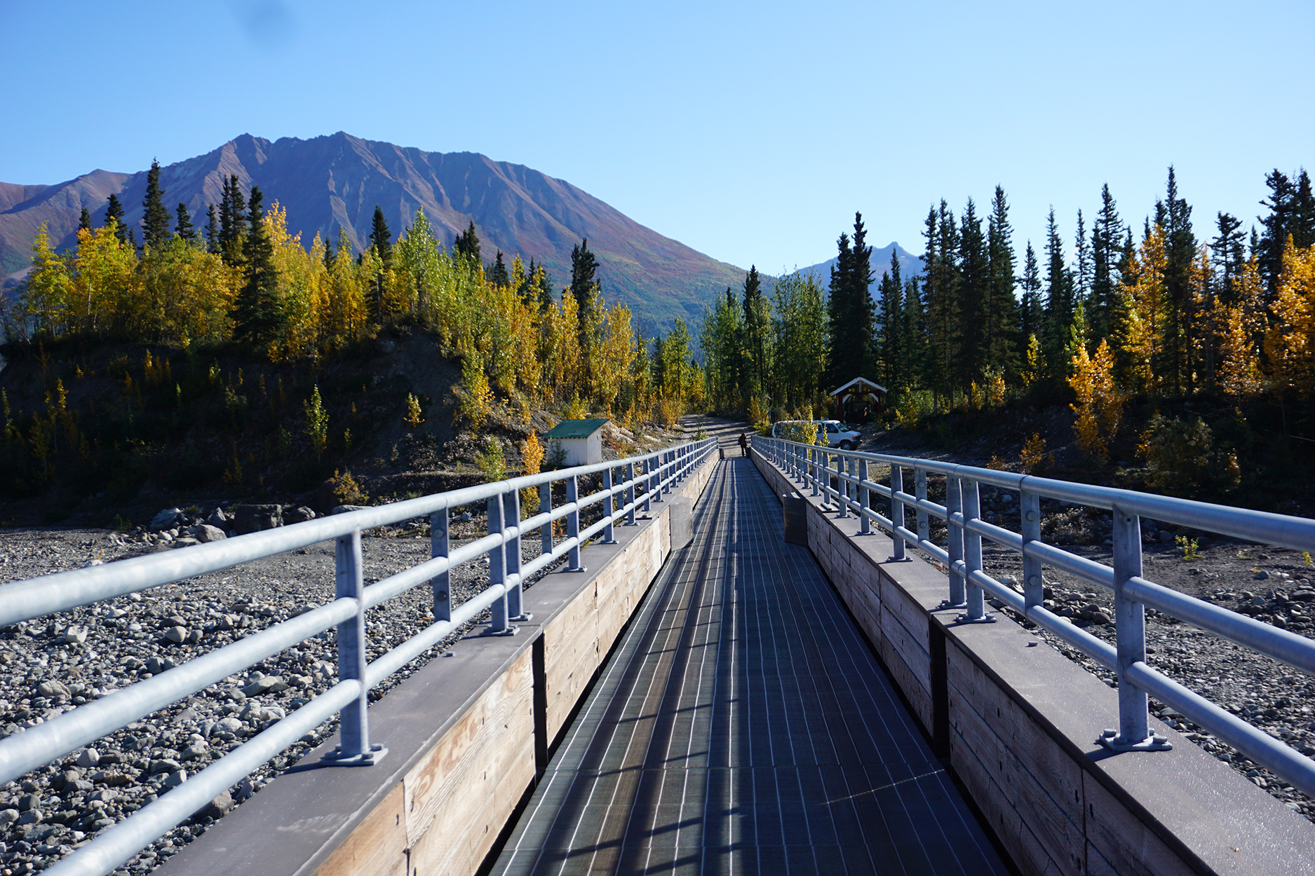
Kennicott River bridge. 2 ¾ minutes.<br />Fifty-nine miles (18 km) east from Chitina, the McCarthy Road dead ends at the Kennicott River. From an open, slightly inclined gravel staging area on the banks of the river, a quarter-mile (400 m) long steel and concrete footbridge, five feet (1.5 m) wide with five-foot (1.5 m) tall metal railings, spans the glacially-birthed torrent.<br />Three- by four-foot (1.25 m) metal, flatbed hand carts with rubber wheels by the side of the bridge may be used to help haul any belongings or luggage across the river.<br />The best place to experience the action at this location is from the bridge. As you move across, the river rises and falls along the banks. Listen for the rocks pushed along under the surface. High above, the mountain provides a stunning backdrop for the Kennicott Glacier and Stairway Icefall. Downstream from the bridge, note an old, hand-pulled, open platform cable tram. Travelers once had to haul themselves across the river on the tram.<br />Once you cross the bridge, a private shuttle takes passengers into the town of McCarthy, about one-half mile (800 m) away, or to the historic mining town of Kennecott, five miles (8 km) away. Note the shuttle does not operate in winter, and there are no Park Service-operated shuttles in McCarthy or Kennecott.<br />About 20 feet (6 m) to the right of the footbridge entrance stands an eight-foot (2.5 m) tall by four-foot (1.25 m) wide wooden information kiosk. An enlarged satellite map of the area in the middle of a posted Park Service information panel shows the Kennicott Glacier in the center flanked by Wrangell-St. Elias National Preserve on either side. The bridge is at the bottom of the map, alongside the town of McCarthy on the other side of the river. The road to Kennecott curves up and around to the right along the right-hand side of the glacier to the Kennecott Visitor Center at the top. Text above the map informs us that:<br /><br />The McCarthy-Kennecott Area is a mixture of National Preserve, private property and non-federal lands. We ask that you respect the privacy and rights of property owners as you explore the area.<br /><br />At the bottom right, underneath a color photograph of the 14-story red Kennecott mill, text urges you to, "Protect yourself and the resource." It lists of a number of things you can do, including making sure all food and garbage items are stored in a Bear-Resistant Food Container, never to enter any mine openings, and practice "Leave No Trace" principles.<br /><br />
An engineering achievement this cantilevered bridge was constructed in two, brutally cold months in 1910. Perched 238 feet above the Kuskulana, this one lane bridge provides spectacular views but please park on either side of the bridge to explore further.<br />
Kuskulana Bridge. 5 ¼ minutes.<br />Located on McCarthy Road, about one-third of the way from Chitina to McCarthy, the one-lane, 525 foot (160 m) long Kuskulana River Bridge hangs a vertigo-inducing 238 feet (73 m) above the bottom of the a deep, sheer-sided, rocky gorge. <br />An original steel railroad trestle, now a modernized span, is safe to cross by vehicle, on foot, or using a wheelchair, with reinforced planks and guardrails on either side. <br />National Park Service (NPS) outhouses are located in a small gravel parking lot on the McCarthy side of the bridge. It is well worth the time to park and move back onto the bridge from this location. The view of the steep-sided, rocky, black spruce canyon and the silty, rushing Kuskulana River far below is breathtaking, if not a little scary.<br />Be mindful of traffic, however, as there is no separate sidewalk. Note also that the road deck drops off immediately underneath the guardrail. <br />Imagine making the crossing riding high in a heavily loaded ore train across two icy rails with no guardrails. <br />Pulling into the NPS parking lot from McCarthy Road, the parking area is to the right, about 30 feet (9 m) across from a small, gravelly area with two picnic tables. Note a 10-foot (2.75 m) tall by 10-foot wide wooden information kiosk to the left of the tables.<br />At the back of the lot, note the small, one-story red and white outhouse building to the right about 40 feet (12 m) beyond the picnic tables. The building houses two gender-neutral restroom facilities. Both are wheelchair accessible, but note the gravel lot continues right up to the doorway of the building, with a small concrete lip threshold.<br />A set of bear-safe garbage cans are available about 15 feet (4.5 m) back to the right beyond the restrooms.<br />On the front side of the information kiosk, a black-and-white photograph fills the top of the first of two park service information panels. Entitled "Railway to Riches," a steam locomotive pulls a line of freight cars along a narrow railroad bed cut into a steep mountainside. Text underneath the photograph reads:<br /><br />From 1911-1938 the Copper River & Northwestern Railway was the lifeline for the Kennecott mines. Nicknamed the "Can't Run & Never Will" by its skeptics, the CR&NW overcame incredible challenges in its construction and operation.<br /><br />A map across the center shows the route of the railway from Kennecott, across the Kuskulana Bridge into Chitina, and ultimately to Cordova on the Gulf of Alaska. Text tells how the railway blasted and carved through the wilderness, and negotiated massive cliffs, raging rivers, frozen ground, and even icebergs to haul ore to market, and supplies to the mines. <br />A line of smaller black-and-white photographs along the bottom of the panel shows dangerous rock work, a train buried in snow drifts, laying track, steam shovel work, the Kennicott Trestle washing out and men blasting through rock at Woods Canyon.<br />A black-and-white photograph of a train crossing a different tall trestle fills the top of the second information panel at the right. Entitled "Wooden Wonder," this panel tells the story of the amazing and perilous construction of the 90-foot (28 m) tall and 880-foot (268 m) long wooden railroad trestle across Gilahina River. It was constructed in the dead of winter in 1911, in temperatures as low as minus 67 degrees Fahrenheit (minus 55 degrees Celsius). In spite of the terrible conditions, the Gilahina Trestle was completed in just eight days!<br />A black-and-white picture in the center shows the long, sweeping curve of the trestle above a snowy, tree-filled valley. A caption below another picture of the cross-hatched wooden trestle at the right reads in part:<br /><br />Sparks from passing trains were a serious risk to wooden trestles. Water barrels placed along the tracks were used for putting out small fires.<br /><br />A line of smaller black-and-white photographs along the bottom of this panel show makeshift wooden houses in a construction camp at Strelna, a line of pack horses hauling supplies, a railroad track cache, thousands of full ore bags in Kennecott waiting for the railroad to be finished, a view of the half-finished trestle at Gilahina and a railcar crossing the finished Gillahina Trestle. <br />The first of two additional panels on the back of the kiosk at the left, entitled "Gateway to Adventure," provides a map and specific site information about the spectacular scenery and vast wilderness along the 60 mile (96 km) long McCarthy Road. <br />The final panel on the right reviews the sport hunting regulations and restrictions in the McCarthy Road area. A map at the bottom shows the road crossing through a patchwork of different colored boxes, all identified by a legend key at the left showing what lands belong to whom, both public and private. A caption reads:<br /><br />Respect Private Property<br />Almost a million acres of private land lies within the boundary of Wrangell-St. Elias National Park and Preserve...Always obtain permission before entering private land.<br /><br />
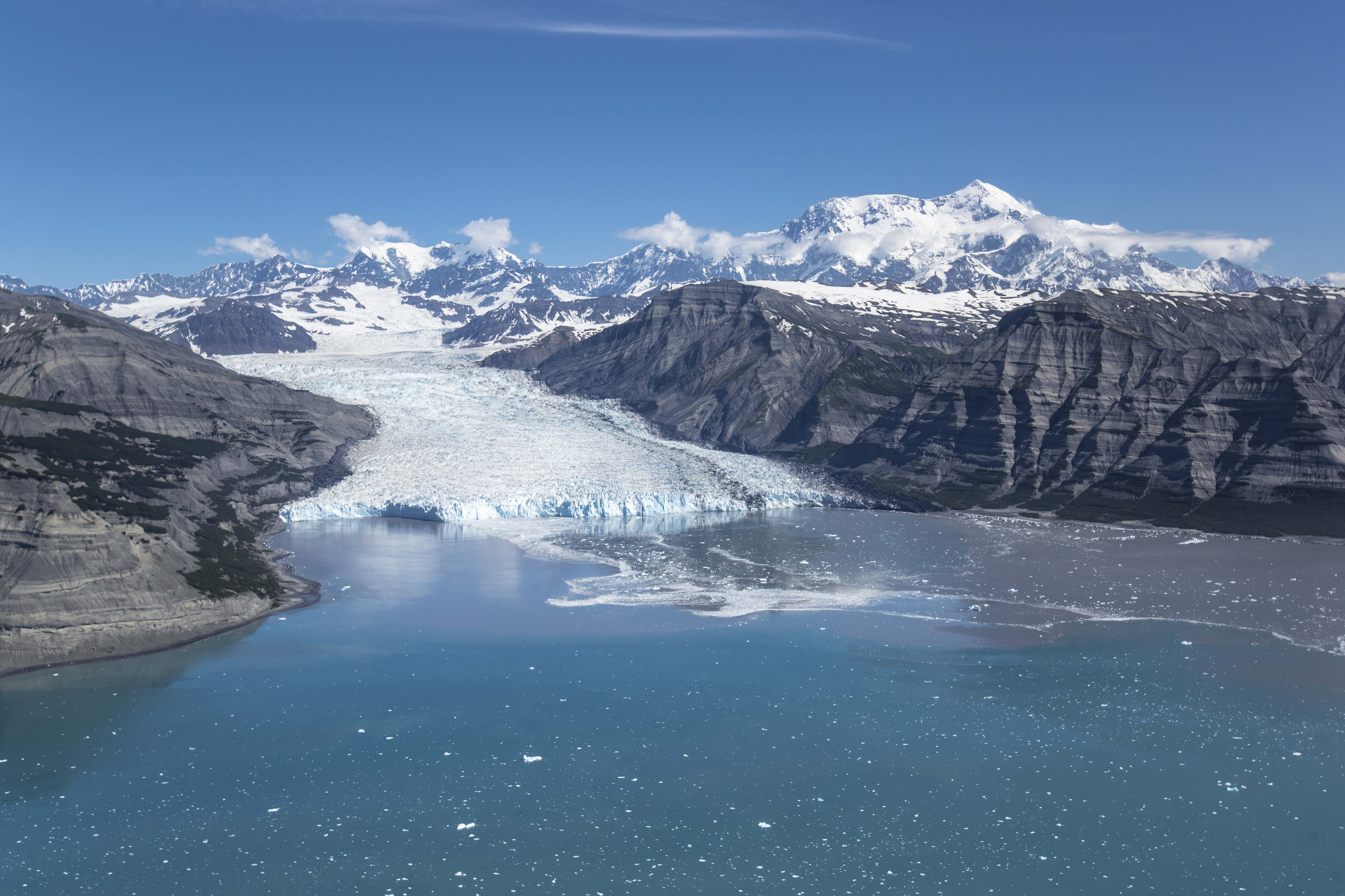
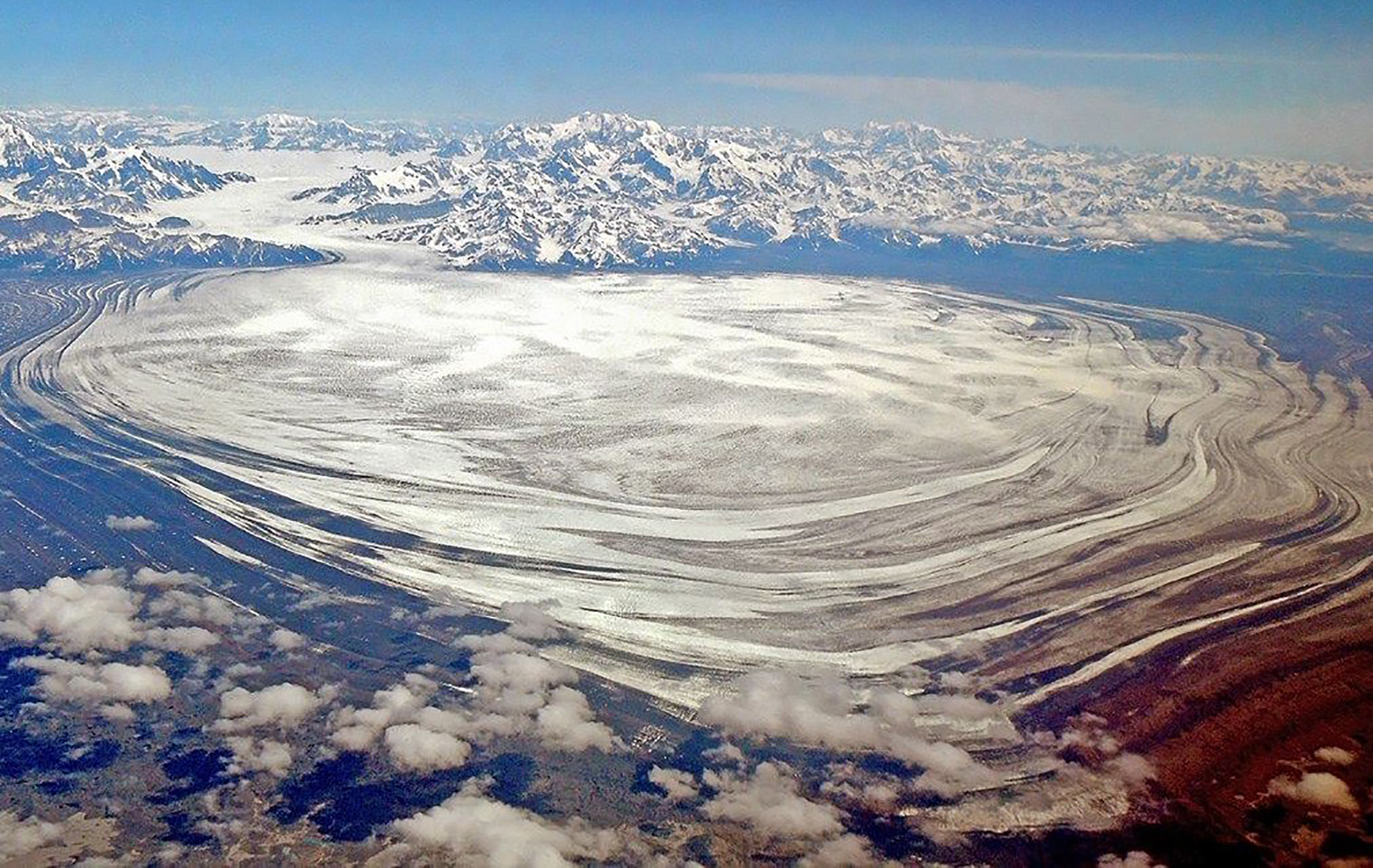
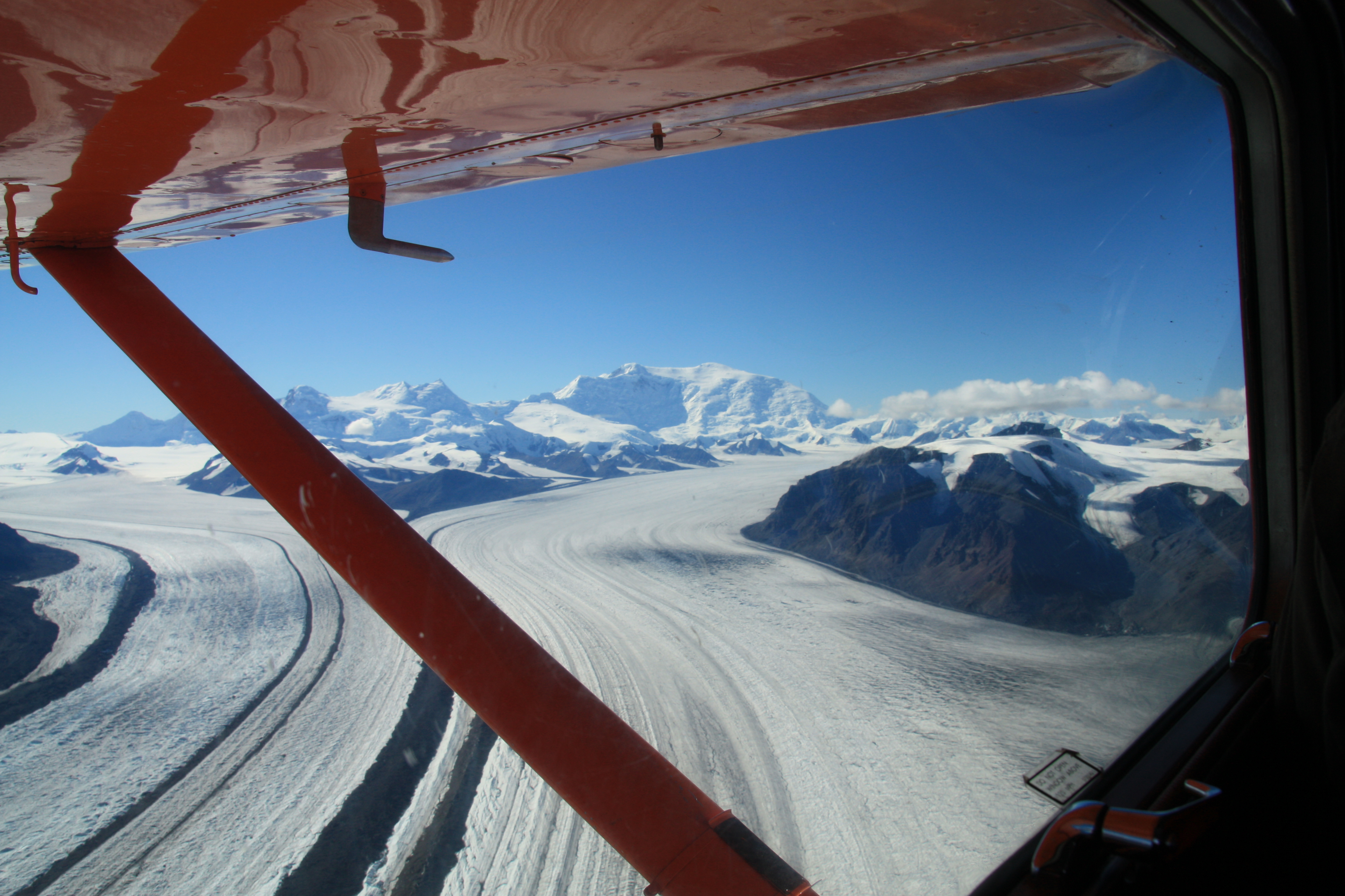
Malaspina Glacier, located primarily within Wrangell-St. Elias National Park on the coast, is the largest piedmont glacier in North America and one of the largest outside the ice cap regions of the world. Latitude: 59.971466064453125 Longitude: -140.52377319335938
Malaspina Glacier, located primarily within Wrangell-St. Elias National Park on the coast, is the largest piedmont glacier in North America and one of the largest outside the ice cap regions of the world. It provides classic examples of glacial mechanisms and fluctuations. This large body of ice has been noted by explorers concerned with navigation of the western coast of North America for more than two centuries. It was designated as a National Natural Landscape in 1968, and is 1,075,409 acres large.
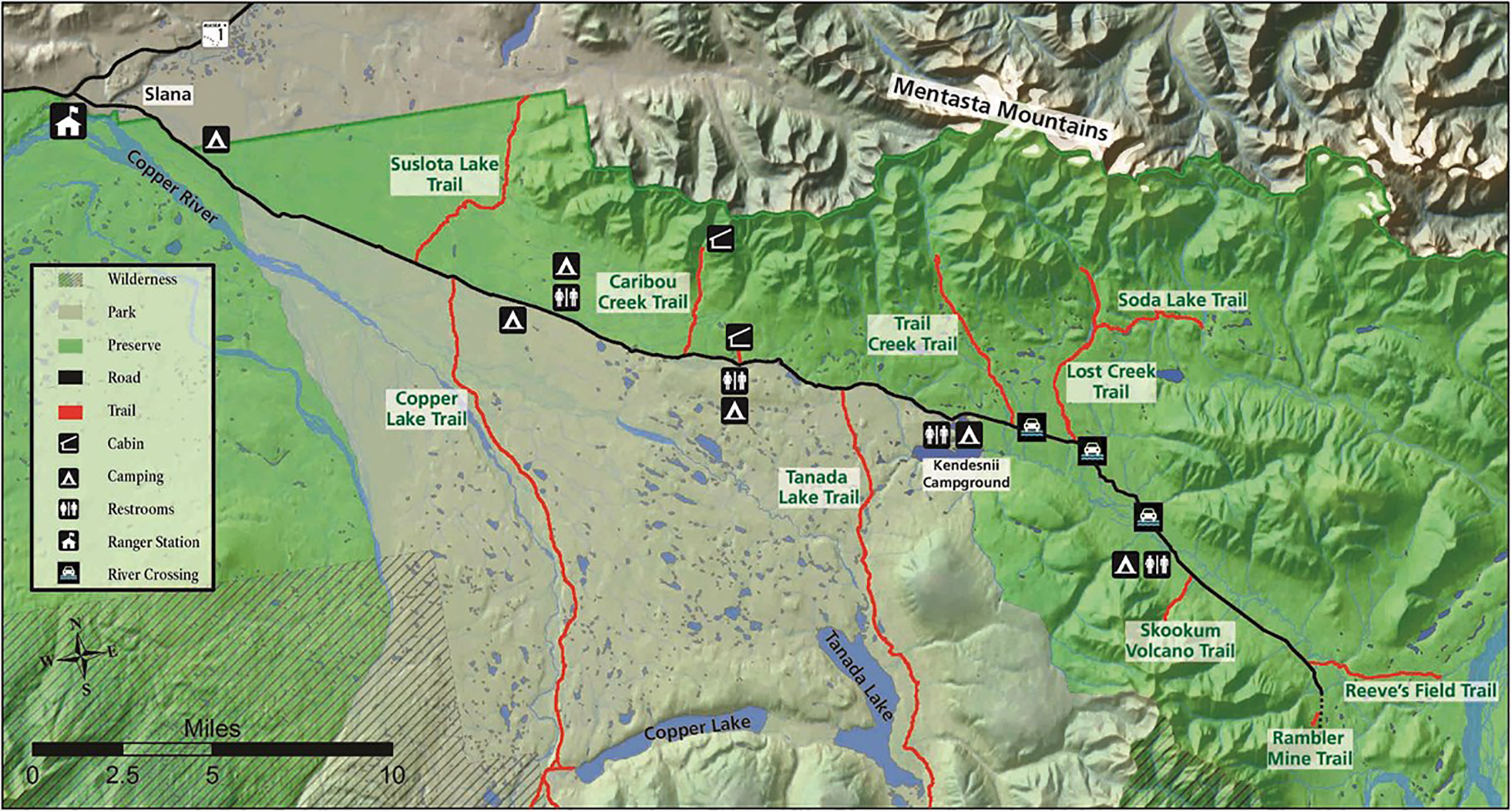
This area encompasses the Nabesna Road and nearby area. Starting at mile 60 of the Tok Cutoff Highway, the Nabesna Road starts at Slana and is nestled in a valley between two mountain ranges, the Alaska Range and the Wrangell Mountain Range. The scenic Mentasta Mountains are the foothills of the Alaska Range and there are several small lakes and rivers which offer endless opportunities for outdoor recreation. Drive, Hike, bike, picnic scenic views and wildlife viewing!
Nabesna Road Audio Tour Script Track Names: 1. Slana Ranger Station to Slana River Bridge 2. Slana River Bridge to 4-Mile Road Junction 3. 4-Mile Road Junction to the Park/Preserve Sign at Mile 5.6 4. Park/Preserve Sign at Mile 5.6 to Copper Lake Trailhead 5. Copper Lake Trailhead to Dead Dog Hill 6. Dead Dog Hill to Caribou Creek Trailhead 7. Caribou Creek Trailhead to Rock Lake Rest Area 8. Rock Lake Rest Area to the Camping Area at Twin Lakes 9. The Camping Area at Twin Lakes to Lost Creek Trailhead 10.Lost Creek Trailhead to Jack Creek Rest Area 11.Jack Creek Rest Area to Skookum Volcano Trailhead 12.Skookum Volcano Trailhead to Reeve’s Field 13.The End of the Road! 14.Wrangell-St. Elias National Park Visitor Center, in Copper Center 15.Chitina, the McCarthy Road, and Kennecott Mill Town 16. Conservation and Research Efforts in Wrangell-St. Elias National Park & Preserve Track 1: Slana Ranger Station to Slana River Bridge Welcome to Wrangell-St. Elias National Park & Preserve, America’s largest national park! What has brought you here? Are you just passing by? Are you curious? Are you here to explore? If you’re looking for a chance to experience Alaskan wilderness, you’ve come to the right place. You’re about to embark on a trip down the Nabesna road: built for a gold mine, yet today providing access to so much more. There is much to discover here! As you drive this road, you’ll catch a glimpse into the interior of Alaska. Today, you may see moose grazing on willow twigs, a herd of caribou trotting through a meadow, or a pair of swans gliding across a lake. As you drive, you’ll see majestic mountains, shaped by glaciers and volcanoes, set within breathtaking landscapes. There is also a fascinating history of people who have made this land their home, both in the past and in the present. The Nabesna Road stretches for 42 scenic miles, and it’s much the same today as it was when it was built back in 1934. Generally, the Nabesna Road is passable by any two-wheel drive vehicle. But sometimes, especially after it has rained, the road may become rough and you may need a four wheel drive vehicle. Please be cautious and take care, as there may be uneven surfaces, potholes, and washouts present. Driving the Nabesna Road can be an adventure! Have fun and take it slow. Soak it in. Pull over, step out of your vehicle, and take a deep breath of the Alaskan air. Drink in the beauty. And take notice of the rich interplay of the wildlife, people, and landscape around you—all held within the wilderness of Wrangell-St. Elias National Park and Preserve. (Music fades in and ends) This concludes Track 1. At this time, go ahead and pause or stop this recording. Proceed to Track 2 during your drive between the Slana River Bridge and 4-Mile Road Junction. Track 2: Slana River Bridge to 4-Mile Road Junction (Music starts and fades out) You’ve just crossed over the Slana River, which drains off of the Mentasta Mountains, located to your left as you drive the road. This pristine river empties into the Copper River just two miles downstream from the Slana Bridge, making the Slana River part of the Copper River watershed. This watershed shapes the dramatic landscape of Wrangell-St. Elias, and it is the lifeblood of the park's varied ecosystems. With an abundance of wide open spaces and hundreds of miles of streams draining into the Copper River watershed, Wrangell-St. Elias is home to a tremendous array of fish resources. The Copper River and most of its tributaries are migration routes for sockeye, coho, and king salmon, and pink and chum salmon can be found in the park as well. Adult salmon begin this migration cycle by swimming upstream from the Gulf of Alaska to build a nest, spawn, and deposit their eggs. These fish return to the stream where they were born, bringing a gift of life.
This building had three ways to generate electricity: diesel gas generators, steam generators, and a Pelton waterwheel. Steam for heating, electricity and compressed air moved from this plant through warm utilidoors built under the wooden, snow-free sidewalks found throughout the mill camp.<br />
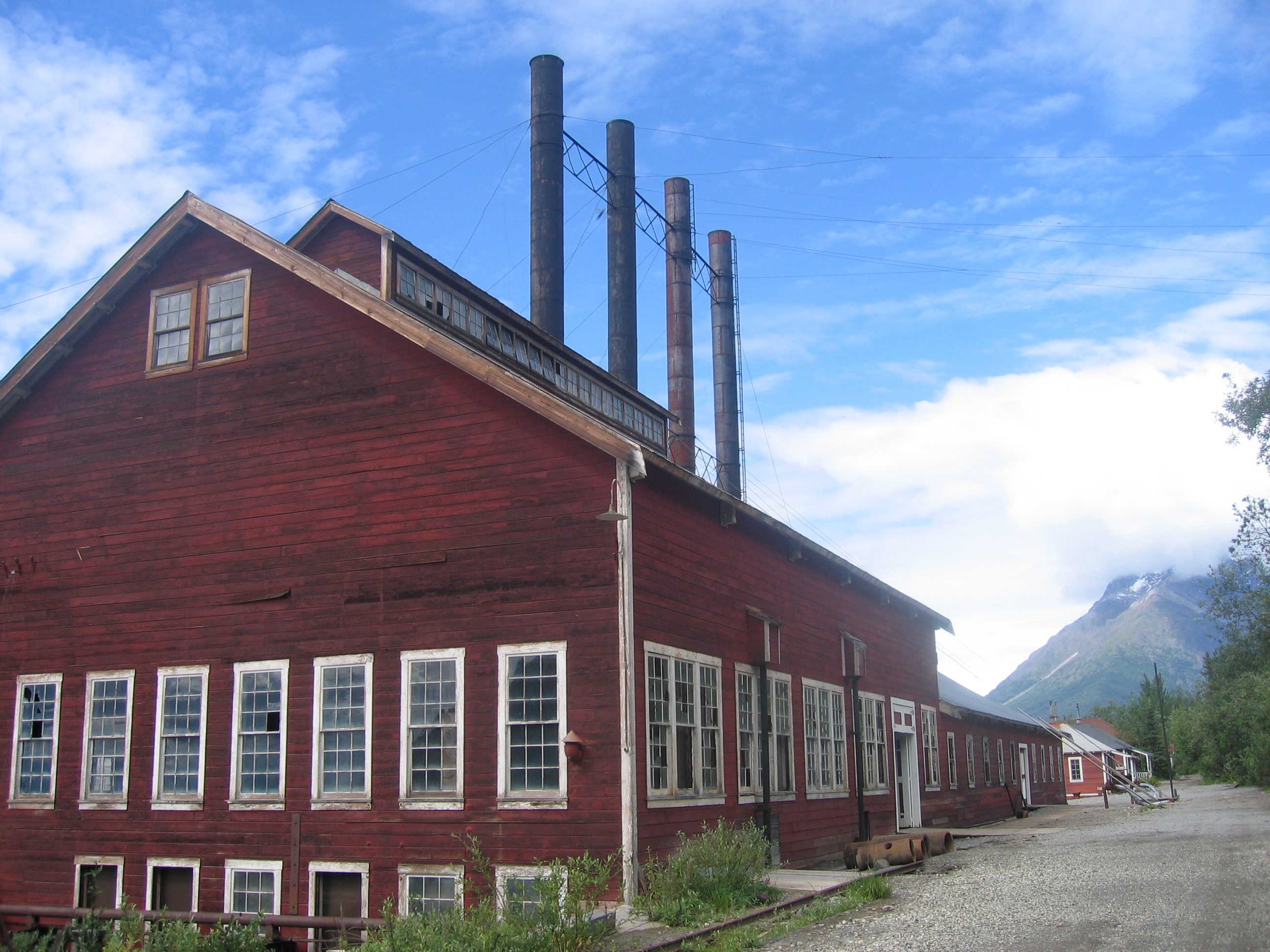
"Power Plant. 4 ½ minutes.<br />Located at the northern end of town along the west side of the main gravel road, four towering smoke stacks rise from the three-story, 13,218 square foot (4,025 square meter) Power Plant. <br />As you move along the road toward the center of the plant, be mindful of rusted metal rails and other large metal debris lying in front of the nearly 120 foot (36 m) long structure.<br />Banks of three, eight-foot (2.5 m) tall by 10-foot (2.75 m) wide double hung white windows line the walls of the first section of the long red building.<br />A 10-foot (2.75 m) wide wood plank boardwalk near the end of this portion of the plant leads over a set of railroad tracks and over a small wooden threshold through a set of double red and white wooden doors onto a 10-foot (2.75 m) wide by five-foot (1.5 m) deep metal platform. A four-foot (1.25 m) tall metal railing surrounds the platform, with metal mesh screening between the rails.<br />The platform looks out over the power plant floor, to four enormous, two-story tall boilers at the right. A smokestack rises up from each, penetrating the roof and reaching for the sky beyond. To the left and right, additional large tanks and pipes line the periphery of the inside walls of the plant.<br />Straight ahead, on a catwalk on the other side of the plant, across the shop floor, a seven-foot (2.1 m) tall black-and-white floor-standing photograph shows a man in a long-sleeve shirt, tie, soft-billed cap and overalls standing before the turbines holding a pair of gloves. Mr. McGavoch was one of the electrician's here at the plant.<br />A three and a half-foot (1.1 m) wide angled information panel mounted flush with the top of the railing at the left tells the story of the Power Plant. Text next to an image of an early electric light bulb reads:<br /><br />Built and expanded 1911-1917, rebuilt after the 1924 fire, restoration completed in 2014<br />Power was essential for Kennecott operations<br />In the earliest years, a small wood-burning boiler powered the sawmill. The first of the boilers in front of you came up when the railway was completed in 1911. As the others were added, this became one of the largest power plants in Alaska.<br />The boilers burned oil to generate steam. The steam generated electricity in the Mill's steam turbines, heated the ammonia reaction in the leaching plant, and warmed buildings throughout the Mill camp. The diesel-electric generators (to your left) sent electricity to the camp, Mill, trams, and mines. The Pelton wheel generator hiding behind them was used in emergencies. Multiple ways to generate power meant that even if something went wrong, operations could continue.<br /><br />A black-and-white photograph at the right side of the panel shows an aerial view of the plant from the west. A quote at the bottom of the panel reads:<br /><br />"An oil storage tank located on the hill above the power plant held enough oil to operate Kennecott all winter...At 30 degrees below zero, the steam plant was a nice place to work."<br />-Wesley Bloom, journeyman electrician at Kennecott, 1935-1937<br /><br />From this location, note an exterior, four-foot (1.25 m) wide wood plank boardwalk, parallel to the plant that runs about 60 feet (18 m) north to a second, wooden observation platform inside the plant at the left. Inside, the boardwalk extends left from the platform, snaking around some of the pipes and tanks inside the plant, providing additional viewing vantage points closer to the boilers and smokestacks.<br />Power played a critical role in Kennecott's self-sufficiency. Industry requires power, and generating power in the wilderness, on a sizable scale, required imagination and herculean effort. The plant provided power and steam heat to the entire town. Steam traveled to outlying buildings through underground wooden conduits. These were often built under wooden sidewalks, keeping them free of snow and ice in the winter. Water for the steam boilers was diverted from Bonanza Creek, north of the town. Power was also transmitted over a high-tension line to Bonanza and then across the hill to Jumbo.<br />"<br />
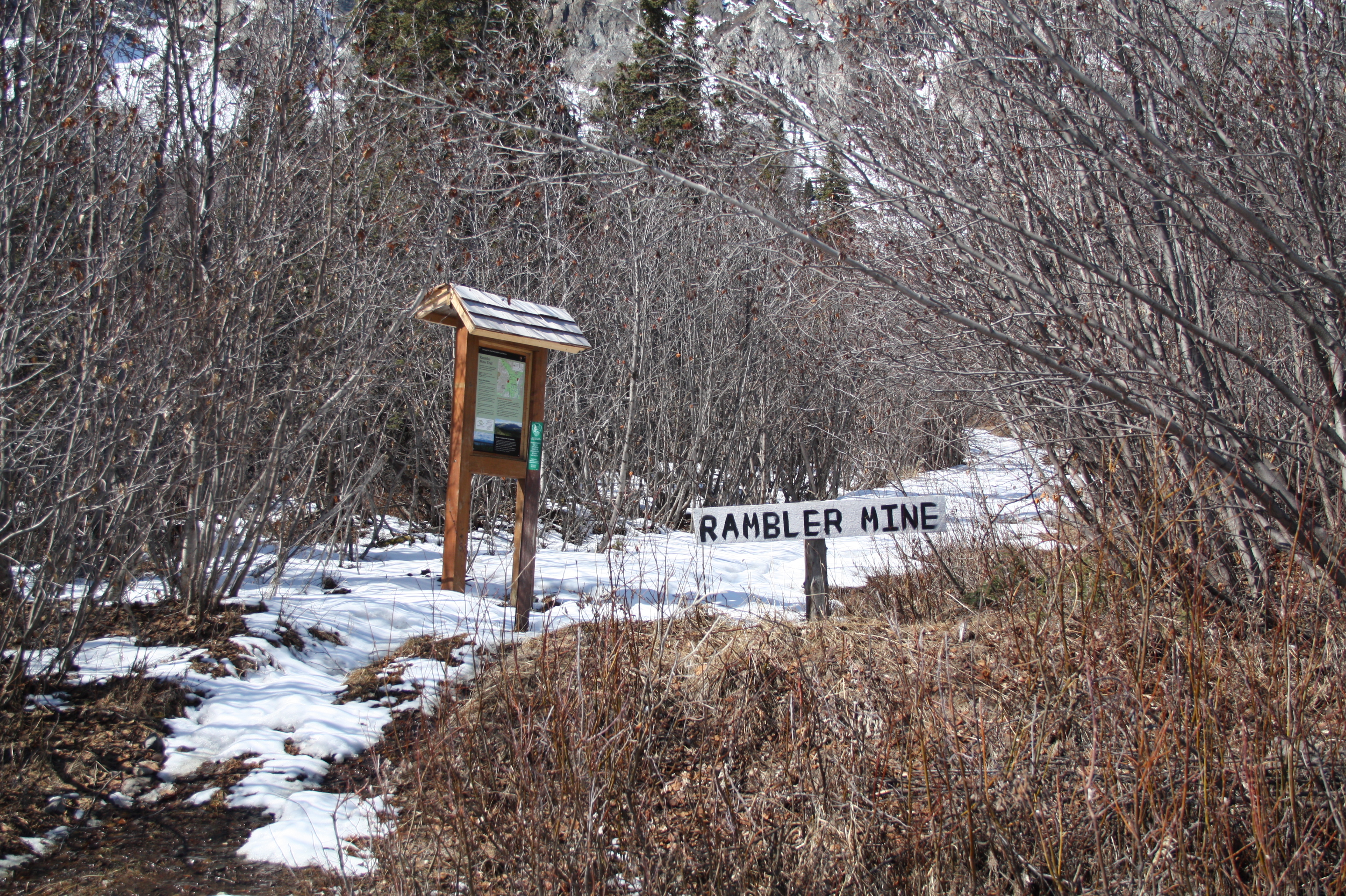
Mile 42.5 Nabesna Road. The maintained portion of the Nabesna Road ends at the Lodge, which is private property. Please respect this property and their privacy. Be careful not to park on the airstrip. Parking: Approximately a 1/4 mile beyond the lodge, there is a gravel parking area that is located on public land. Since the road is not maintained beyond this point, continue by foot to the Rambler Mine trailhead. The strenuous trail leads uphill (south) to the mine ruins.
Mile 42.5 Nabesna Road. The maintained portion of the Nabesna Road ends at the Devil's Mountain Lodge, which is private property. Please respect this property and their privacy. Stay alert, and be careful not to park on the airstrip. Parking: Approximately a 1/4 mile beyond the lodge, there is a gravel parking area that is located on public land. Since the road is not maintained beyond this point, continue by foot to the Rambler Mine trailhead. The trail leads uphill (south) toward the remains of the abandoned Rambler Mine, a gold mining area that was active in the late 1940s. The one mile trail is strenuous and steep but has superlative views of the Nabesna River and the Nutzotin Mountains.
This 1916 building was the place for community recreation, entertainment and social gatherings. Here they had silent movies, holiday pageants, basketball and shuffleboard, fraternity meetings. It is still used today. There are two vault toilets behind it.<br />It can be rented out for events
"Recreation Hall. 12 minutes.Located 50 feet (15 m) to the north from the Kennicott Glacier Lodge, a set of wooden stairs and a wheelchair accessible ramp around the building from below, leads to a one-story red and white wooden building.Using the stairs, from the main gravel road, proceed 13 steps down a set of four-foot (1.25 m) wide wooden stairs, with four-foot (1.25 m) tall railings on either side, to a small wooden landing. Proceed down nine more steps to an eight-foot (2.5 m) wide by 19 foot (5.8 m) long wooden platform in front of the Recreation Hall. The single red and white wood door entrance is located in the middle of the building.Note the wheelchair accessible ramp is located on the west side of the building, but is reachable only from the lower service road. Note also there are two, red and white, gender neutral accessible outhouses near the base of the ramp, located immediately to the south along a 10-foot (2.75 m) gravel driveway leading west back to the service road.Facing the front door, exercise caution moving over the slightly raised wooden threshold onto the hardwood floor of a small, 10-square foot (three-square meter) anteroom. At the right, two pot belly stoves sit on a single-brick raised platform. At the left, a two and a half-foot (0.75 m) tall flip book display, mounted on an angle, stands in front of a three and a half-foot (1.1 m) wide by seven-foot (2.1 m) tall wall panel at the back. The panel presents information about the activities that took place here, while the flipbook offers more vignettes about the community's social and political history up to the present day.Beyond this entrance area, the hall opens up into a 30-foot (9 m) wide by 50-foot (15 m) long open, rectangular room with 15 foot (4.5 m) ceilings. Rows of six-foot (2 m) square windows line the center of both walls, looking up to the mountains on the east and out over the Kennicott Glacier on the west. Rows of wooden benches at the base of the walls sit on opposite sides of the dark, hardwood floor. A large movie screen hangs at the back of the hall, and there's a modern, black and silver wood stove in the far back left corner.Back inside the anteroom, facing the two pot belly stoves, the stove at the left is identified as a Great Western wood burning stove. It stands six feet (2 m) tall with a nearly three-foot (1 m) wide square black base. It has a generally cylindrical body with metal castings and hardware that rises to another dark cylinder at the top, connecting to a stovepipe into the ceiling above. Feel free to explore this original artifact.Opposite the stove, a black-and-white photograph at the top of the wall panel shows the frontier buildings and town of Kennecott in the early 20th century. A hand-written musical score appears across the bottom of the panel. Next to an image in the center of a pair of brown leather boxing gloves with green lacing, text reads:Recreation HallBuilt in 1916, restoration complete in 2003A place to socialize and celebrateThe twinkle of lights and sound of music enticed managers, their families, and workers to fill the Recreation Hall for dances, symphonies, school plays, Christmas pageants, movies, the occasional church service, and indoor sports like basketball, shuffleboard, roller skating, wrestling, and boxing matches. Organizing and enjoying these activities together helped create a sense of community among employees.The Kennecott Copper Corporation provided the Recreation Hall and other comforts to attract and keep workers. In exchange, the Corporation expected them to work hard and stay out of trouble.Below this text, between the wall panel and the flip book, note a music stand on the vignette with some sheet music from the era. There is also a lady's dance card from the 1920s for use at Kennecott dances, with numbered lines and a white string loop and small tassel.Turning to the first page of the flip book, a quote at the top of the dark purple page reads:"Such an abundance of dancing partners."Text continues:Dances were held in the Recreation Hall two to four times a month in the 1920s, although this dwindled to once a month by the late 1930s. In those decades, dancing required a partner of the opposite sex, but women-nurses, teachers, secretaries, and wives-were in short supply at Kennecott. To keep things orderly and to be sure that everyone had a turn, men reserved a dance by writing their name on a lady's dance card. Dance cards could fill up very quickly.A quote at the bottom reads:"There is a recreation hall where a few of the dances-the big ones like New Years and Fourth of July, etc., are held and everybody attends... the men outnumber [us] ... and no matter how much your feet hurt or your knees weaken, you have to keep on dancing."- Ethel LeCount in a letter to a friend, 1938.To the right on page two, a black-and-white photograph shows a line of men in suits and women in long elegant dresses standing underneath hundreds of strands of twisted streamers.
This 4.2 mile trail leads to the views of the Nabesna River. Though Reeve's Field airstrip is not longer here, this area is historically significant. During 1941, trucks hauled equipment from Valdez to a rustic airstrip along the river. Pilot Bob Reeve cut the equipment into pieces, loaded it into his Boeing Trimotor, flew them to Northway about 40 miles north and had them re-welded. This effort was to build the Northway Airport to defend Alaska during WWII.
Mile 40.2 Nabesna Road. The first two miles is suitable for hiking, but beyond that, it becomes a muddy trail not recommended for hikers. Along the trail, please respect private property and take care not to trespass. Though Reeve's Field airstrip is no longer here, this area is historically significant. During 1941, trucks hauled equipment from Valdez to a rustic airstrip along the river. Pilot Bob Reeve cut the equipment into pieces, loaded it into his Boeing Trimotor, flew them to Northway about 40 miles north and had them re-welded. This effort was to build the Northway Airport, a critical stopover in ferrying led-lease aircraft to the Soviet Union during WWII. By November, he had transported all the materials needed for a full-scale airport. One month later the the Japanese attack on Pearl Harbor gave relevance to his work and the airport which was a critical element in the defense of Alaska.
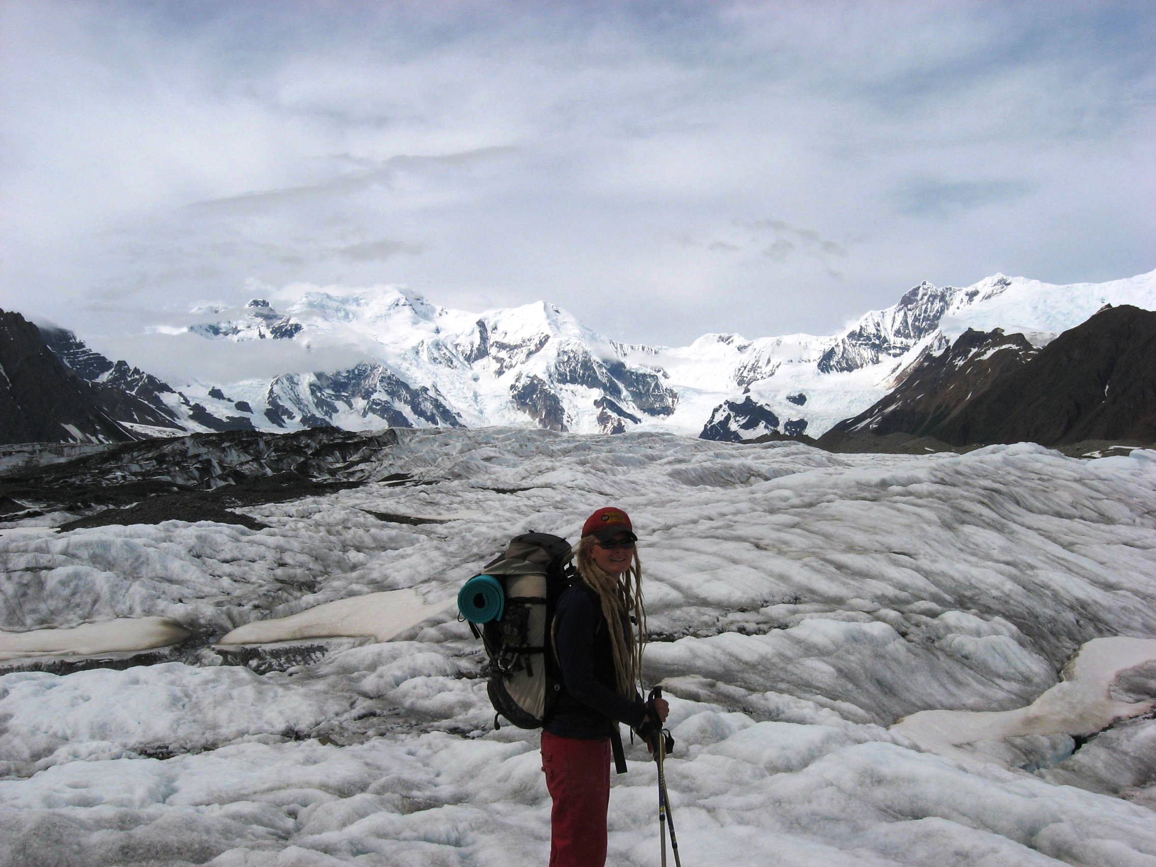
Of the 5,000 square miles of glacial ice in Wrangell-St. Elias, the Root Glacier is the most accessible. A moderate 1 ½ mile walk from the historic mining town of Kennecott along the Root Glacier Trail leads you onto the glacier. Be aware that glaciers can be dangerous. It is recommended to wear crampons or ice spikes on your shoes and go with an experienced guide.
Hike on a glacier. Caution use crampons and go with an experienced guide. 4 miles, 2-4 hours round-trip. Trailhead at Kennecott mill town, 5 miles north of McCarthy.
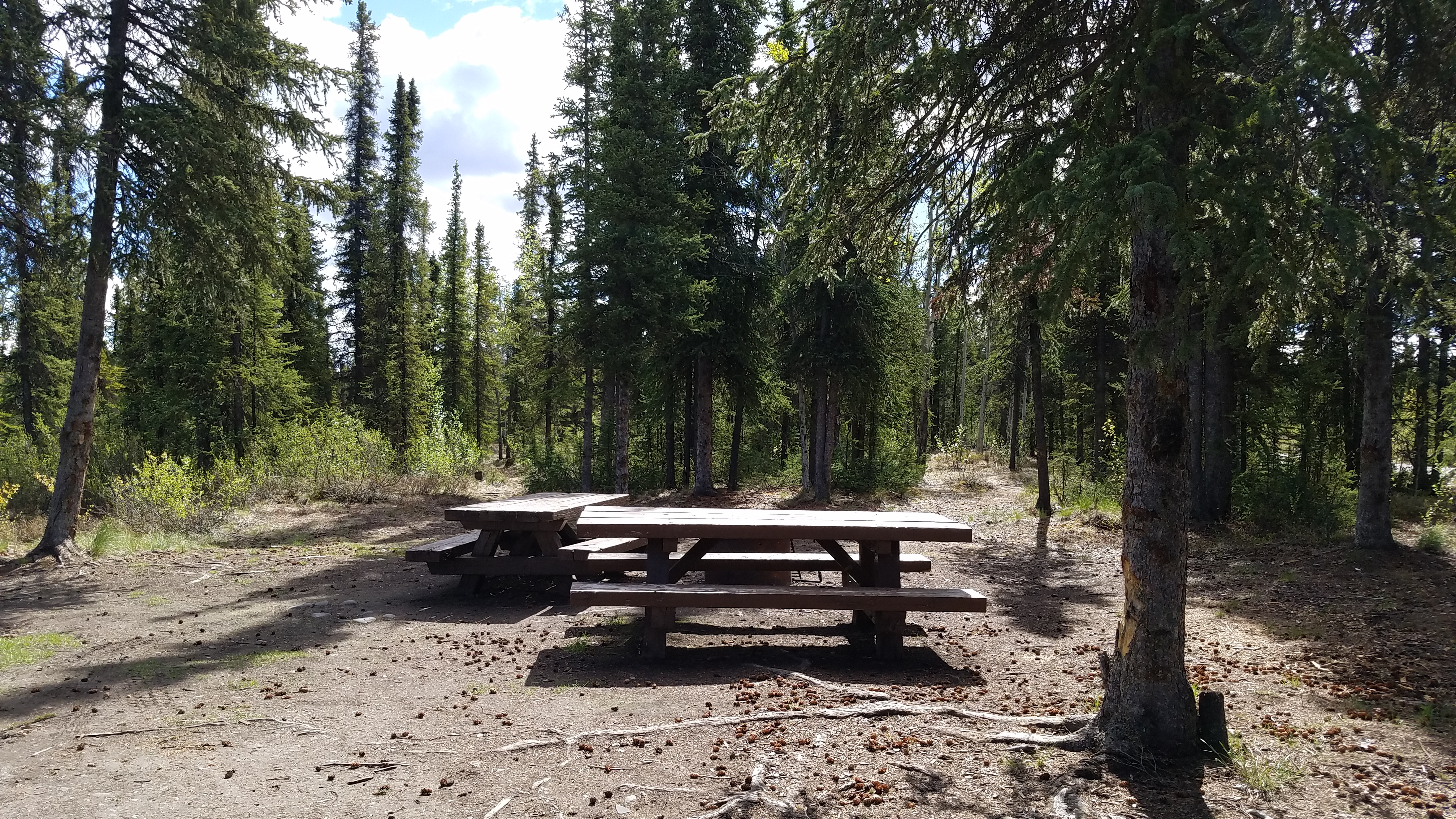
Rufus Creek primitive campsite for one group has a restroom, picnic table, Information board, and fishing in the nearby creek (Dolly Varden, Rainbow Trout). Gravel parking area has space for two regular sized vehicles or one small recreational camper vehicle (RV).
Rufus Creek primitive campsite for one group has a restroom, picnic table, Information board, and fishing in the nearby creek (Dolly Varden, Rainbow Trout). Gravel parking area has space for two regular sized vehicles or one small recreational camper vehicle (RV).
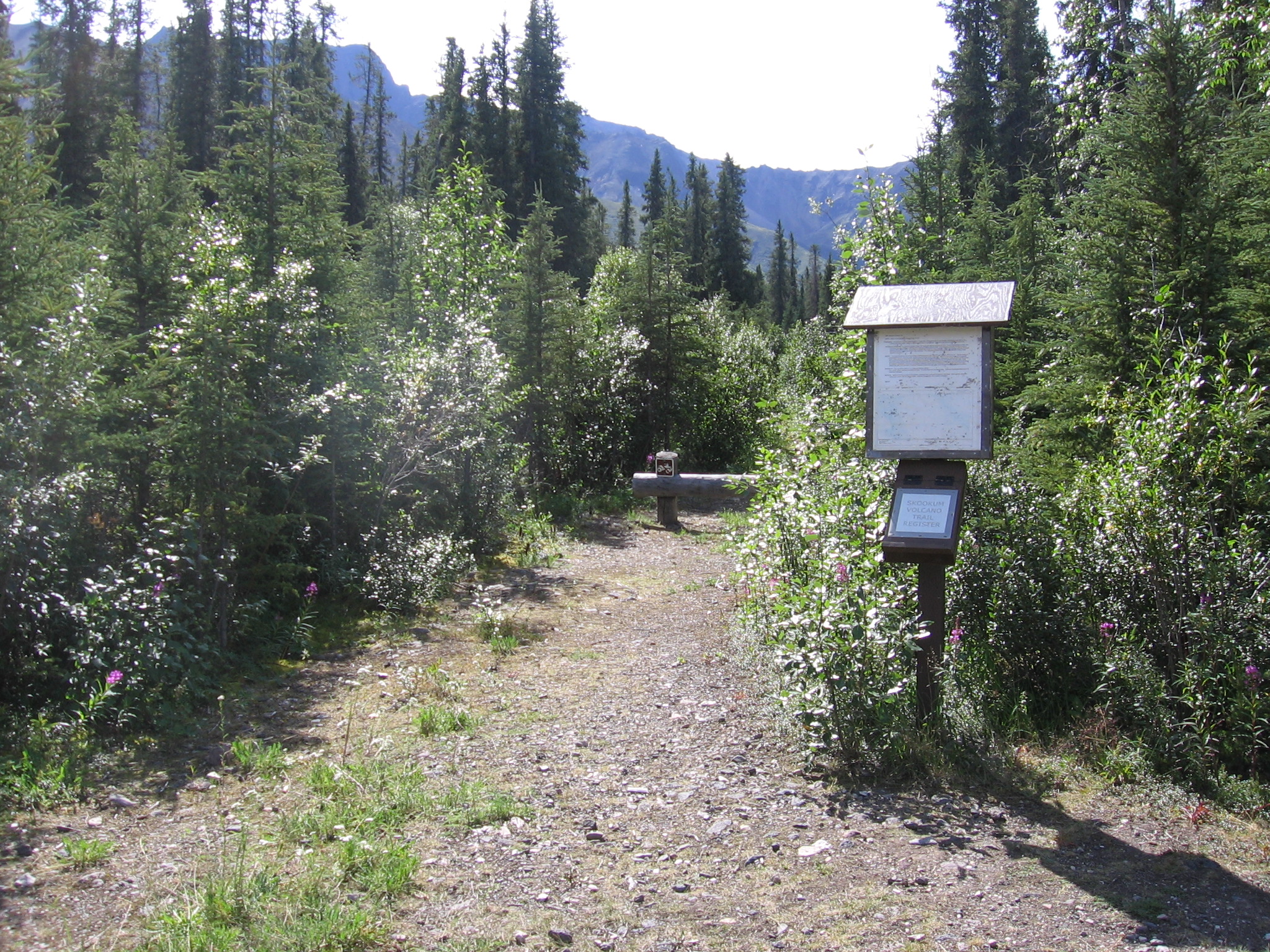
Mile 36.2 Nabesna Road. Skookum Volcano Trail is 2.5 miles one-way to a beautiful high pass. The trail leads through an extinct, deeply eroded volcanic system with fascinating geology two to four million years old. The elevation at the trailhead is 3,000' and rises to an elevation of 4,800' at the pass. Volcanic Ash and hot gasses formed a fiery cloud which flowed down the flanks of the volcano to produce the tan and light gray rocks. Lava formed the pink and rust colored roc
Mile 36.2 Nabesna Road. Skookum Volcano Trail is 2.5 miles one-way to a beautiful high pass.The trail leads through an extinct, deeply eroded volcanic system with fascinating geology. The elevation at the trailhead is 3,000' and rises to an elevation of 4,800' at the pass. Hikers can explore other routes or expand this hike into a multiple-day trip. At this area along Nabesna Road, the jagged peaks south of the road are dominated by volcanic rocks ejected from the Skookum Creek Volcano. Volcanic Ash and hot gasses formed a fiery cloud which flowed down the flanks of the volcano to produce the tan and light gray rocks. Lava which issued from several volcanic vents flowed downslope and solidified to produce the more massive pinkish-tan and rust colored rocks. Radioactive dating of these rocks by USGS investigators shows that Skookum Creek Volcano was active between two and four million years ago. Deep canyons and steep slopes show that erosion has been very effective in wearing down the land during the last two million years.
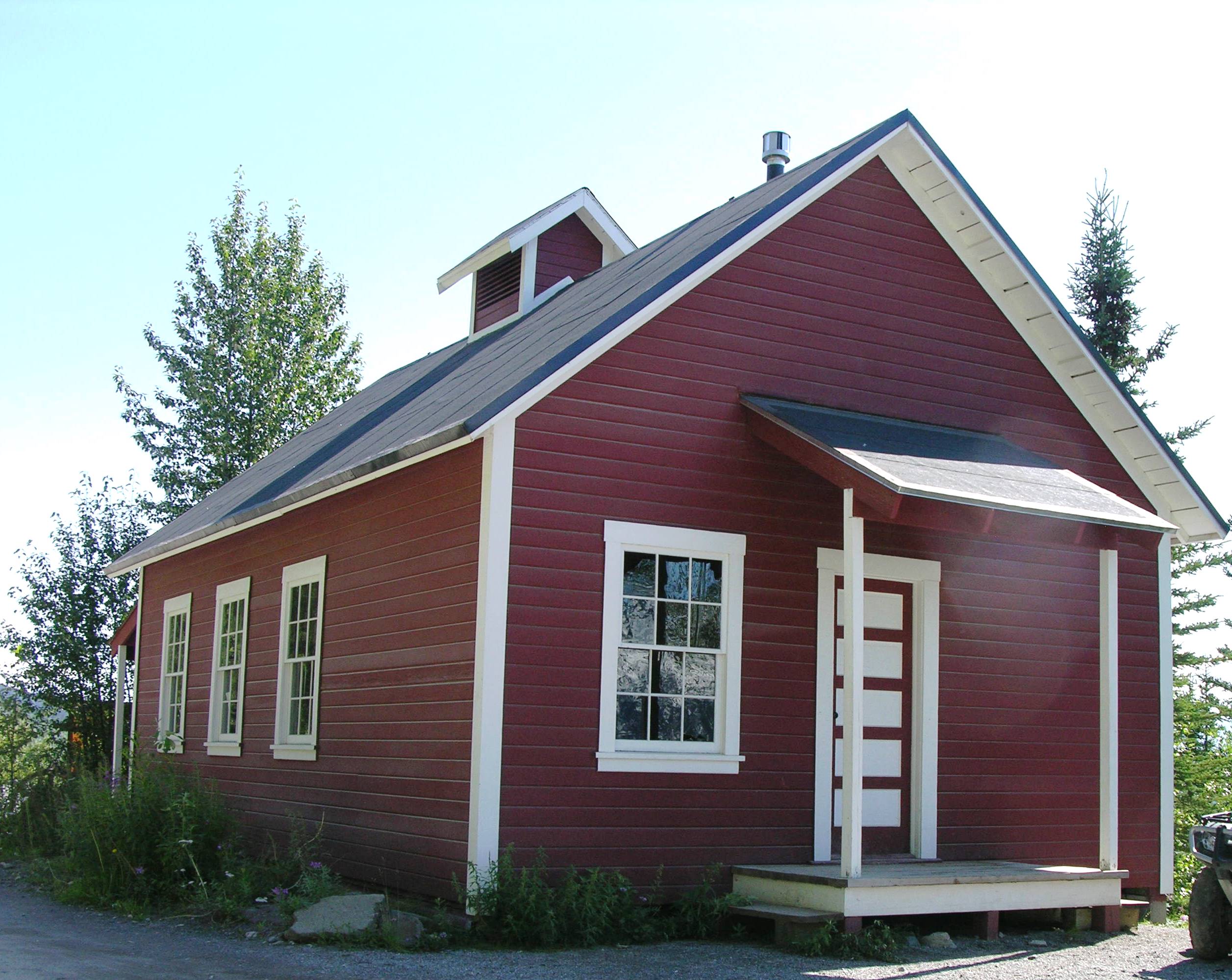
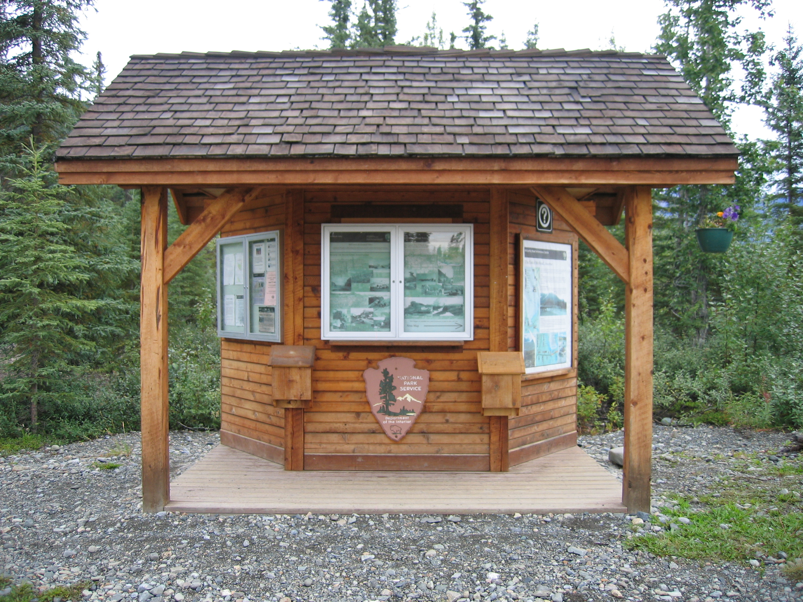
Located in the northern portion of the park, about two hours north of the Wrangell-St. Elias Visitor Center Complex. Slana is east of the Tok-Cutoff Hwy at mile 0.5 Nabesna Road. Call for season dates and hours of operation in Summer (907) 822-7401. The Slana Ranger Station provides information about the northern side of the park and the Nabesna Road as well as trip-planning, things to do, road conditions and subsistence ORV, fishing and hunting permits.
Slana Ranger Station and Visitor Center. 3 ¼ minutes.<br />Located a short distance down a small state road just south of and running parallel to Nabesna Road, a dark wooden sign at the right with the words "Wrangell-St. Elias National Park and Preserve" in white in the center welcomes you to the Slana Ranger Station and Visitor Center. <br />Note a gravel parking lot in front of the one-story, dark red-brown wood structure with a vaulted triangular roof, and a four-foot (1.25 m) tall vertical log railing lines a six-foot (2 m) wide porch in front. To the left, the covered porch extends around and back to the right, along the left-hand side of the building. <br />At the center of the building, a 10-foot (2.75 m) wide, slightly inclined wood plank walkway leads up from the parking lot onto the porch across a rubberized carpet in front of a set of double wood and glass doors. A two-foot tall National Park Service logo hangs above the walkway in front. A tall flag pole in front stands about 10 feet (3 m) to the left of the side porch.<br />A wooden sign hanging on the wall to the left of the front entrance indicates the women's restroom is located straight ahead, inside the building, while the door to the men's restroom is located to the left around the corner on the side of the building, about 30 feet (9 m) back from the front porch.<br />Hanging underneath this sign, note a twenty-four inch (60 cm) wide by 12-inch (30 cm) high wooden box with a number of park brochures, information sheets, and maps.<br />Note a telephone located around the corner, hanging along the left side of the building, about 15 feet (4.5 m) back from the front porch, just past an information display case on the right. In an emergency, please call 9-1-1. Know that you are at the Wrangell-St. Elias National Park Slana Ranger Station on the Nabesna Road in Slana, AK. Otherwise, to contact the Nabesna Ranger, please call NPS Dispatch at (907) 683-9555.<br />A side door to the ranger station is located just beyond the telephone on the right, past a window in the side of the building, and the door to the men's restroom is about six feet (2 m) further on past the side door on the right.<br />Opposite the men's room door, on the other side of the porch, a 10-foot (2.75 m) wide set of three wooden stairs with a wooden railing at the left and right lead down from the porch to a staff gravel parking area.<br />Inside the ranger station, there's an information desk at the immediate left where visitors can get federal subsistence permits, hunting and fishing permits, ATV/UTV permits, road condition information, and participate in the Junior Ranger program. There's a bookstore straight ahead, and a study area with WiFi and a table and chairs at the right. <br />Note the women's restroom is located about 15 feet (4.5 m) straight back from the front door, through a single wooden doorway, about four feet (1.25 m) to the left.<br />
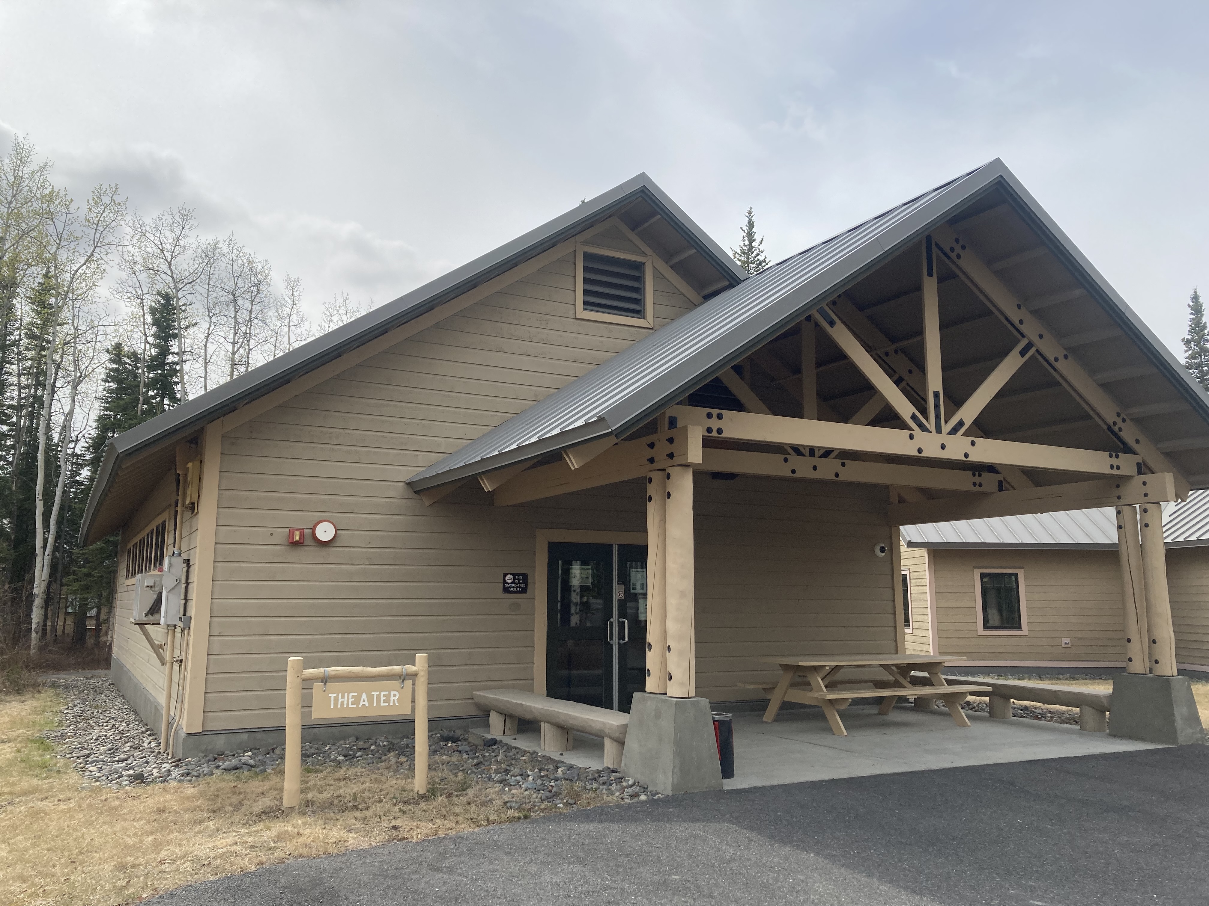
The park film is show here daily upon the hour or upon request on the half hour.
Visitor Center Complex - Theater. 2 minutes.<br />The one-story wood frame Theater Hall building is located about 40 feet (12 m) west from the flag pole outside the visitor center across a small asphalt courtyard. <br />Note some bike racks at the left, and a wooden bench further along in the courtyard, beyond the bike racks. <br />A triangular wooden arch with wooden beams, about 20 feet (6 m) high by 20 feet (6 m) across, hangs over a concrete pad entranceway.<br />Note a bench at the left, a picnic table at the right, and a second bench beyond the picnic table at the right. <br />Moving about 15 feet (4.5 m) across the concrete porch area, a set of double metal and glass doors swing outward across a metal grate. Be mindful of the threshold as you cross from the concrete porch onto a carpeted floor hallway inside the building. <br />You may turn either to the left or right down this hallway, and circle around to the sloped floor of the theater itself. A single seating section in the center of the room has eight rows of wooden benches with backs, stretching 20 feet (6 m) across the room, with a four-foot (1.25 m) aisle on either side. A white movie screen hangs on the wall at the front of the theater, which shows an introductory 22-minute film about Wrangell-St. Elias National Park and Preserve. The film is shown daily, every hour on the hour, from 10:00am to 5:00 pm.<br />The film is open-captioned and audio-described. If you would listen to the film with audio description, please ask a Ranger for a headset next door at the Visitor Center information desk.<br /><br />
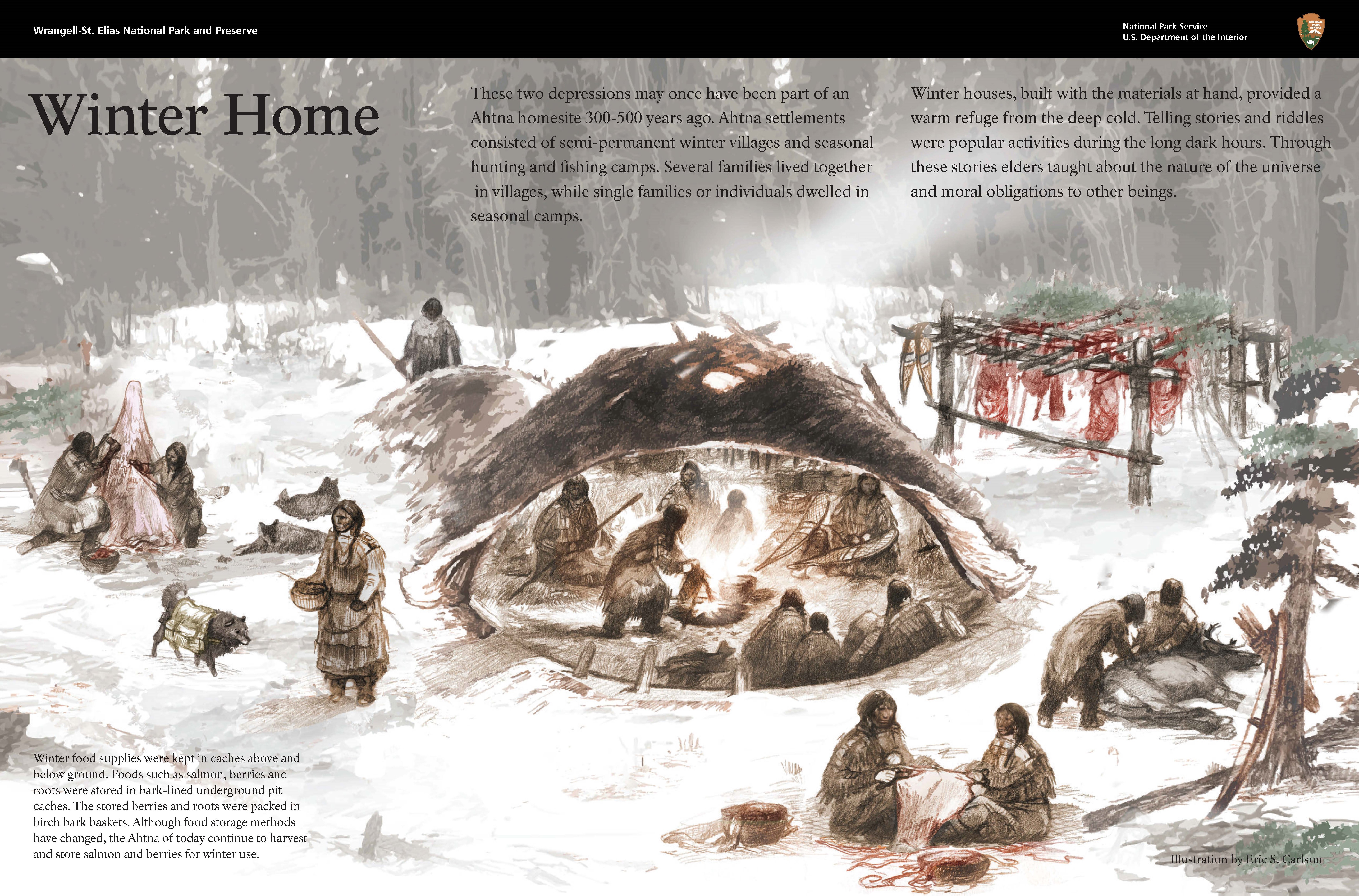
The two depressions on the west side of the trail may once have been part of an Ahtna homesite 300-500 years ago. Ahtna settlements consisted of semi-permanent winter villages and seasonal hunting and fishing camps. Several families lived together in villages, while single families or individuals dwelled in seasonal camps.
The two depressions on the west side of the trail may once have been part of an Ahtna homesite 300-500 years ago. Ahtna settlements consisted of semi-permanent winter villages and seasonal hunting and fishing camps. Several families lived together in villages, while single families or individuals dwelled in seasonal camps. Winter houses, built with the materials at hand, provided a warm refuge from the deep cold. Telling stories and riddles were popular activities during the long dark hours. Through these stories elders taught about the nature of the universe and moral obligations to other beings. Winter food supplies were kept in caches above and below ground. Foods such as salmon, berries and roots were stored in bark-lined underground pit caches. The stored berries and roots were packed in birch bark baskets. Although food storage methods have changed, the Ahtna of today continue to harvest and store salmon and berries for winter use.
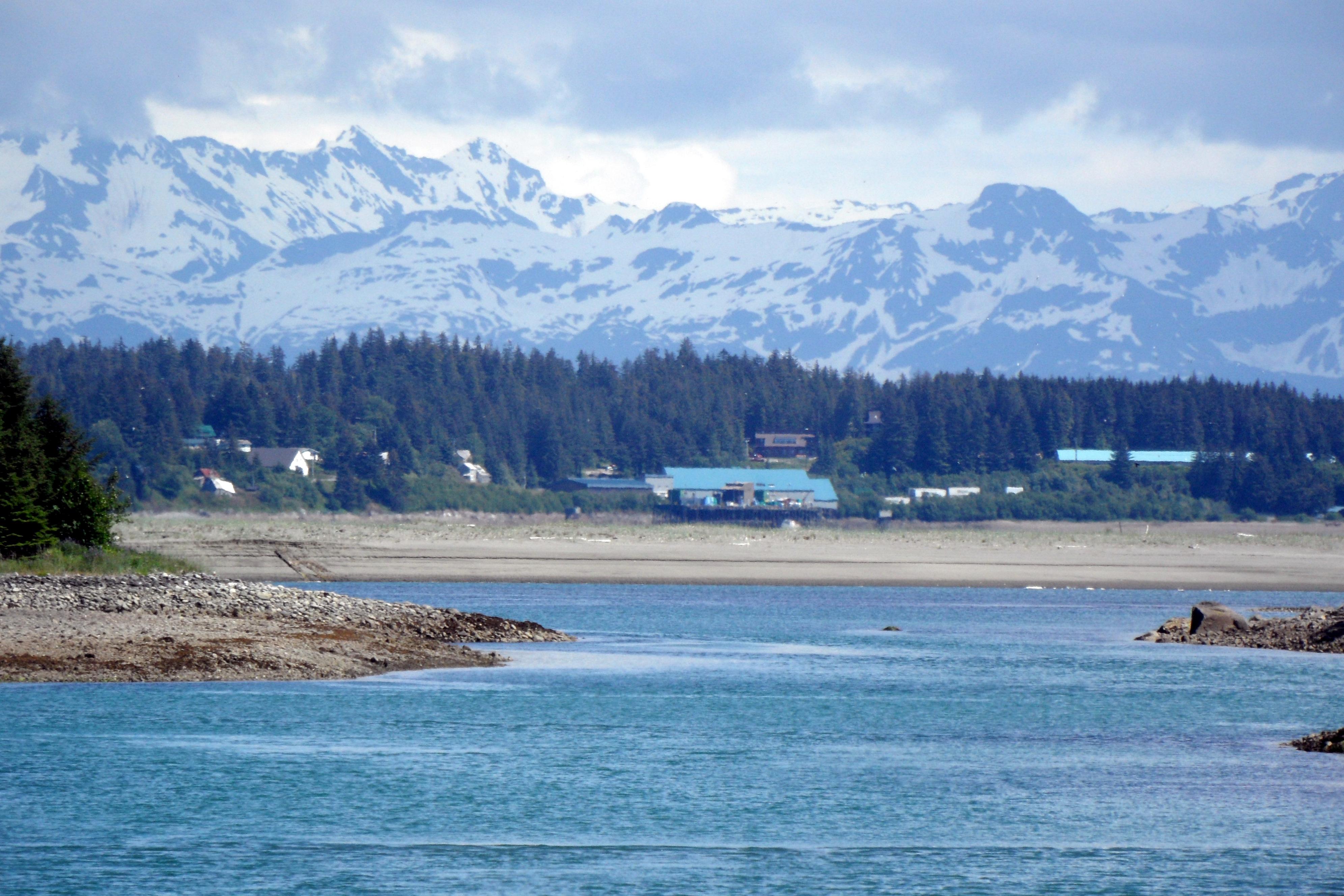
Accessible only by plane or boat, this area encompasses the park's coastal region, with 155 miles of little-known coastline. Here, huge mountains, enormous glaciers, and temperate rainforest meet the ocean. Visitor services are only found in the town of Yakutat, which is a plane or boat ride away from the park. https://www.nps.gov/wrst/planyourvisit/yakutat-and-coast.htm
Accessible only by plane or boat, the Yakutat area encompasses the park's coastal region, with 155 miles of coastline, where huge mountains, enormous glaciers, and temperate rainforest meet the ocean. Visitor services are only found in the town of Yakutat, which is a plane or boat ride away from the park boundary.
Located in downtown Chitina at mile 33 on the Edgerton Highway. Upon entering Chitina town southbound, turn left at the Chitina Hotel, drive down the gravel road 0.2 mile (300 meters), station on left. The light brown historical log cabin with mint green trim is the Chitina Ranger Station.
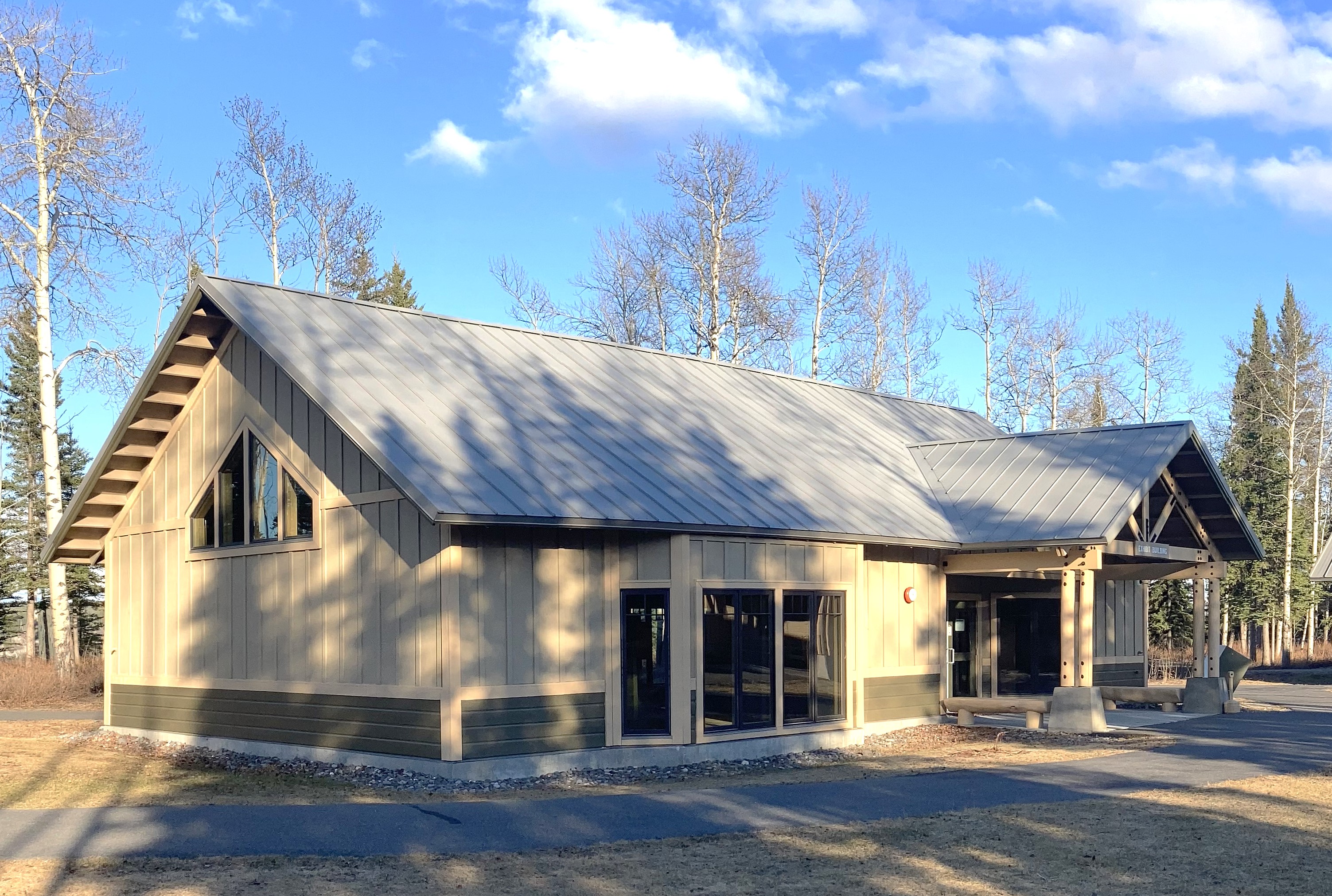
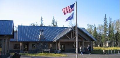
Wrangell-St. Elias Visitor Center in Copper Center
Enjoy the exhibits, view the park film, hike nature trails, shop in the bookstore, gather park & area information, conduct backcountry trip planning, and view the large 3-D interactive map display. Park rangers provide guided talks and walks daily during the summer months. Subsistence fishing and hunting permits are also available for eligible local rural residents.
Yakutat is located in the southern portion of the park along the coastline in Yakutat Bay at the base of the St. Elias Mountains. Accessible only by plane or boat, this area encompasses the park's coastal region, with 155 miles of little-known coastline, where giant mountains, enormous glaciers, and temperate rainforest meet the ocean. For information, please call Park Headquarters in Copper Center at (907) 822-5234.
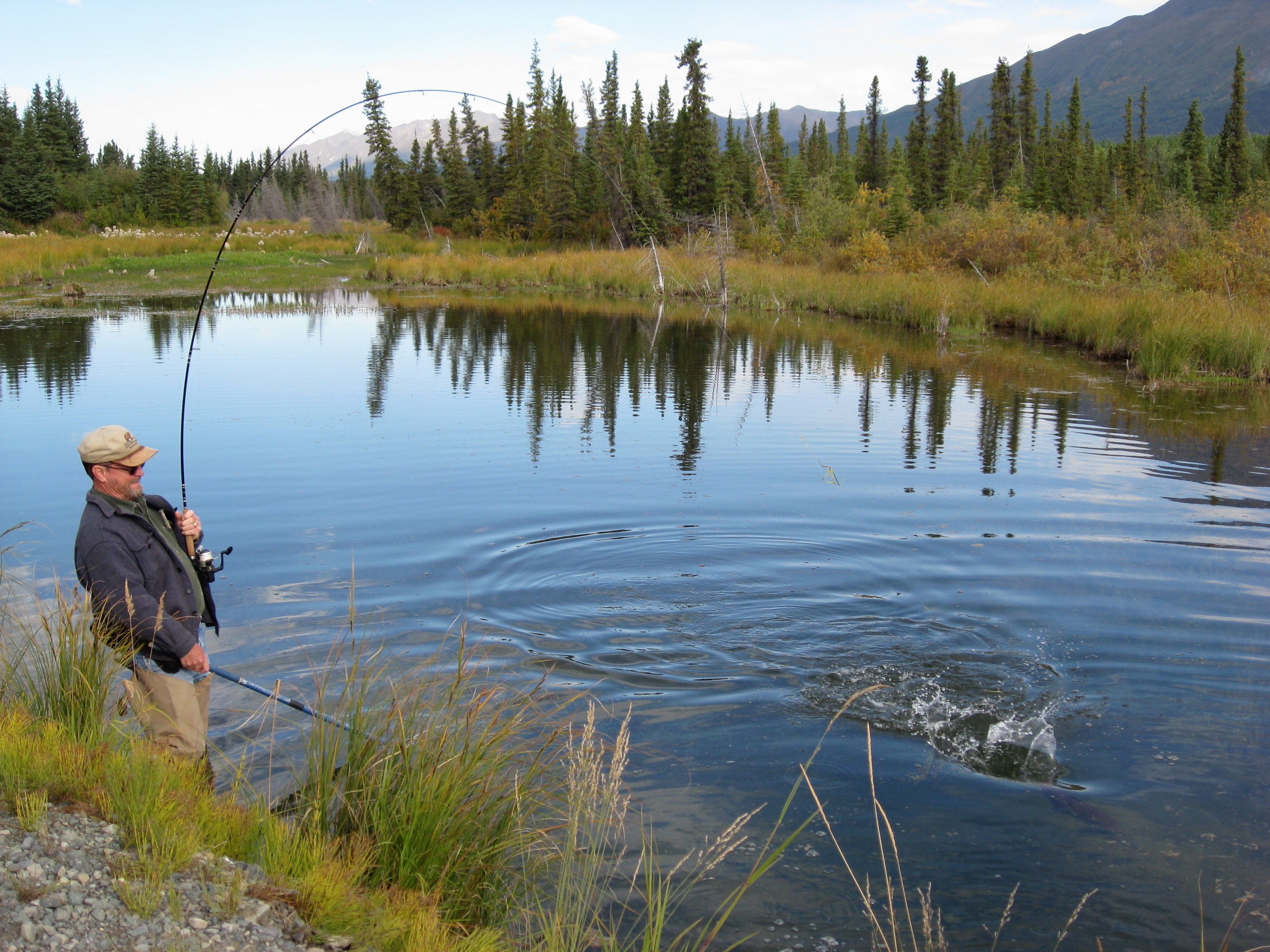
Sport fishing in Wrangell-St. Elias National Park offers many opportunities. Arctic grayling, dolly varden, lake trout, steelhead/rainbow trout, whitefish, sockeye salmon, coho salmon, and chinook salmon are widespread. Nothern Pike, cutthroat trout, chum salmon and pink salmon are also available in select areas. Local residents catch burbot, lake trout, rainbow trout, and whitefish through the ice in the winter.
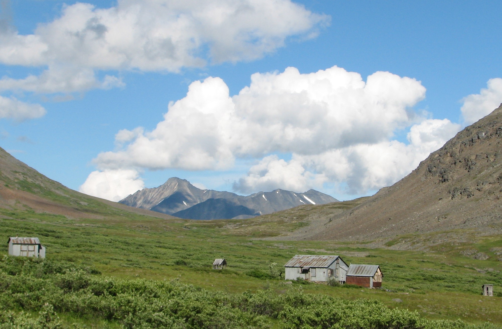
Ghost Towns
Ghost towns were once thriving communities that have dwindled over the decades, often created by the search for gold, copper and other valuable minerals. Some vanished entirely after the boom or were absorbed into newer settlements, but many of these towns still stand today, allowing us a nostalgic glimpse into the past. These places are where people ventured into remote areas to find their mineral fortune and endured the hardships of wilderness, wildlife and weather.
Front country Hiking Trails
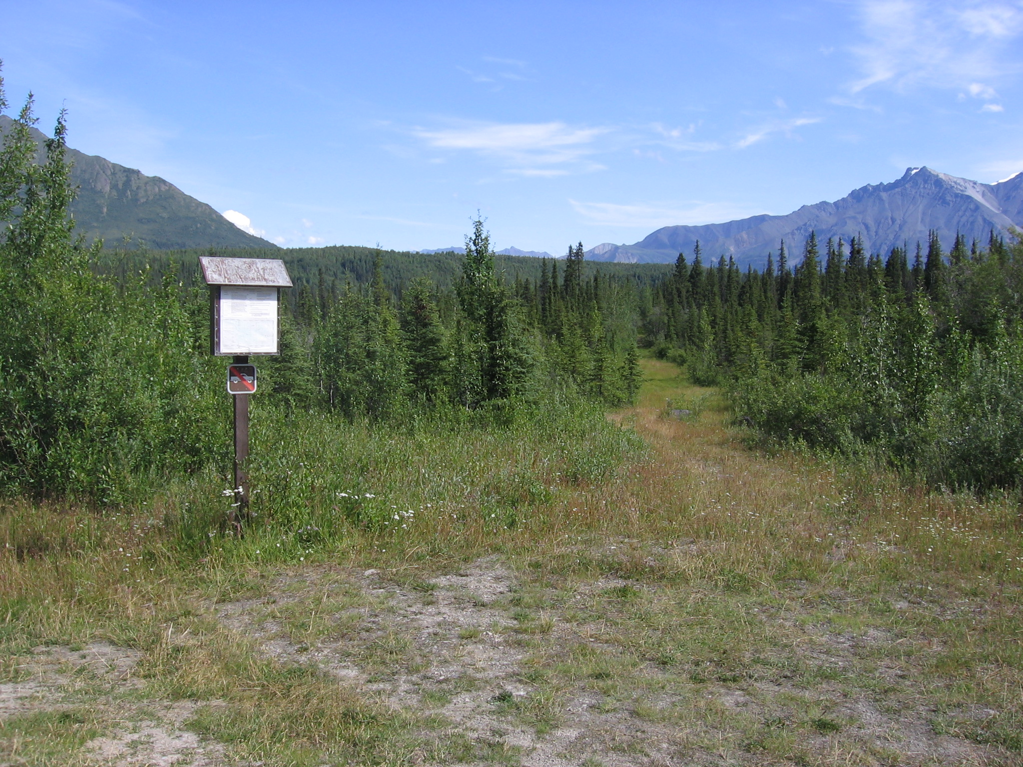
Hiking in Wrangell-St. Elias can be spectacular and we encourage you to go, but be prepared! Most of the front country hiking trails are maintained for the first few miles and then become routes into the backcountry, where route finding and navigational skills are highly recommended. There are hiking trails in the Copper Center area, on Nabesna Road and on McCarthy Road.
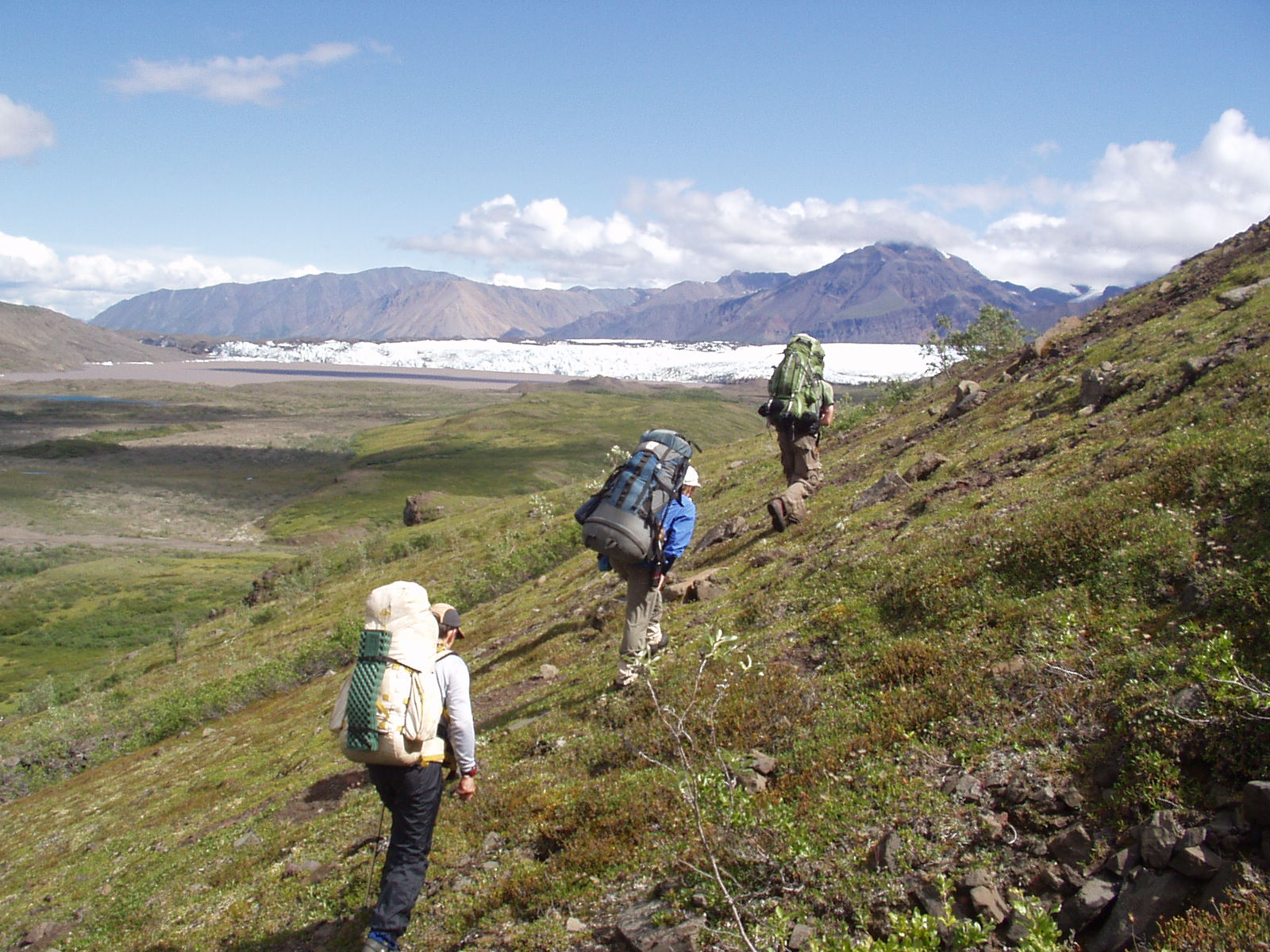
Backpacking in Wrangell-St Elias
A backpacking trip in Wrangell-St. Elias National Park and Preserve can be an exciting and rewarding experience if you are prepared for the difficulties of traveling through rugged, undeveloped land.
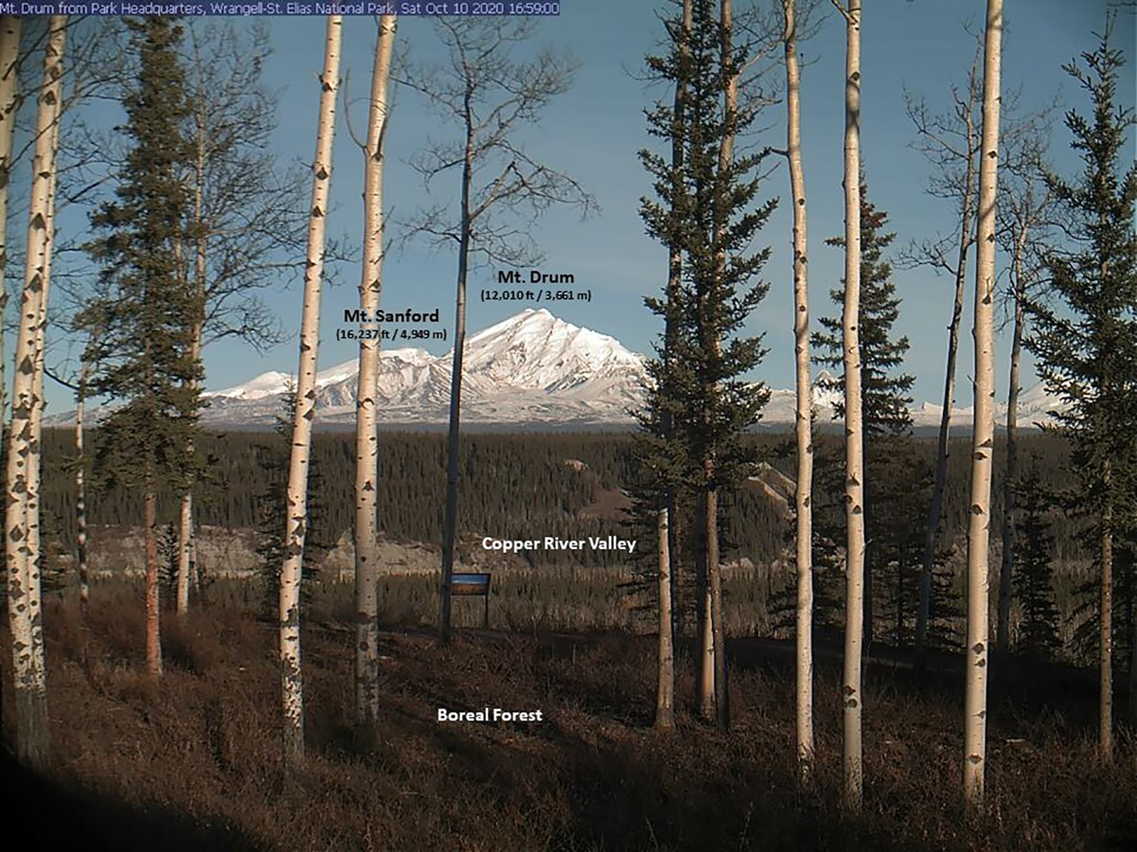
Webcams
Webcam views from the Visitor Center at Park Headquarters in Copper Center, Kennecott Mill and Mt. Blackburn and Kennicott Glacier and the Chugach Range.
Virtual Tours
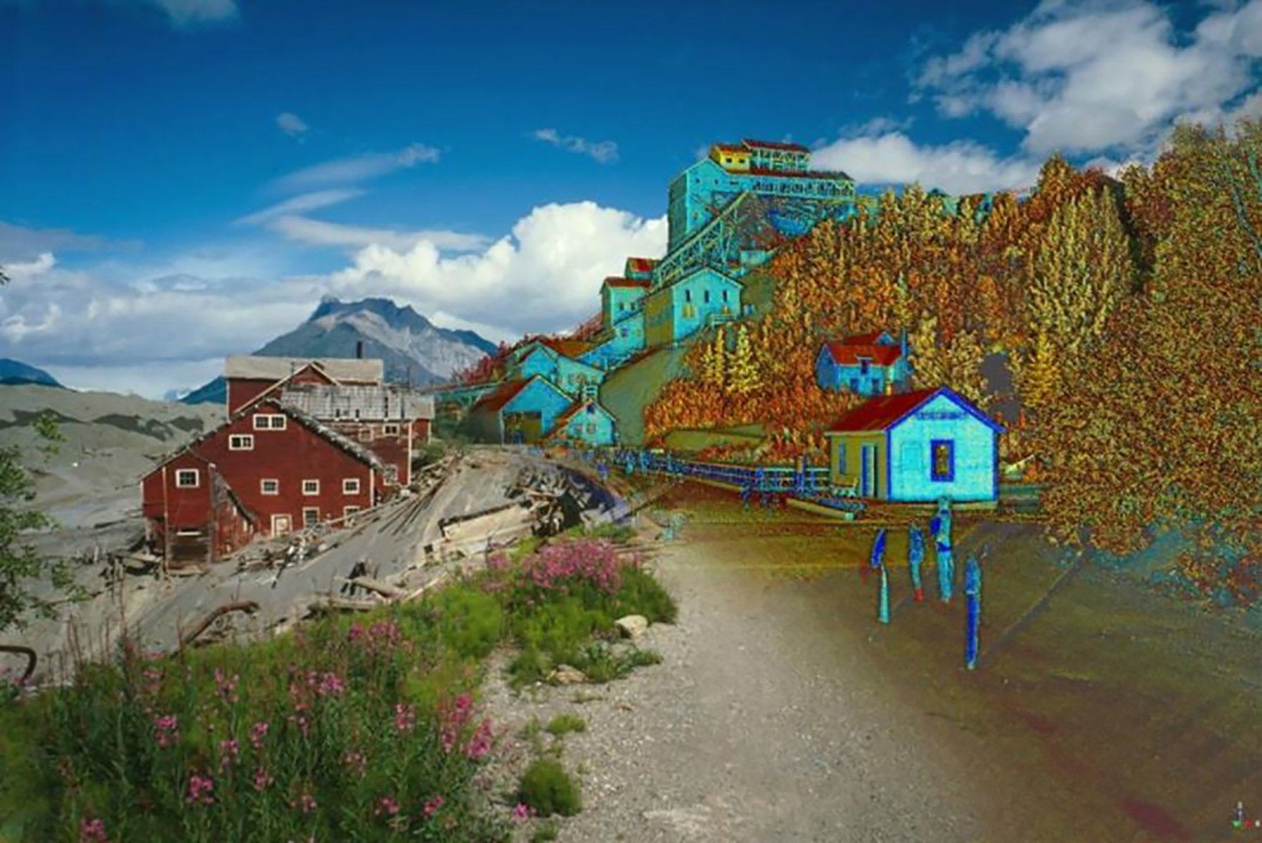
Explore with geologists and their helicopter pilot around Kennicott Glacier on an interactive website virtual tour to learn how National Park Service staff monitor changes in the size of the glacier! Check out the Terrestrial LiDAR Scanning Project with 3-D data collected which provides precise measurements needed for the Stabilization Project of the mill structures.
Soar above mountains that make their own weather and glacier-carved valleys still emerging from the Ice Age, as you return with producer John Grabowska to a place of his boyhood dreams: Wrangell-St. Elias National Park and Preserve. With calving glaciers in hidden fjords, wildlife wandering a vast land and countless unnamed peaks, Wrangell-St. Elias fulfills the romantic, mythic image of Alaska.
Flight Seeing
One of the best ways to experience the beauty and tremendous size of this park is from above! Fly past massive peaks, over jagged glaciers, and endless expanses of wild Alaska! There is a variety of air services available to visitors, including flightseeing excursions and air taxies for backcountry dropoffs for wilderness campers and backpackers. A wide variety of tours, trips, and itineraries are available. https://www.nps.gov/wrst/planyourvisit/air-taxis-flight-seeing.htm
Tours
Count: 5
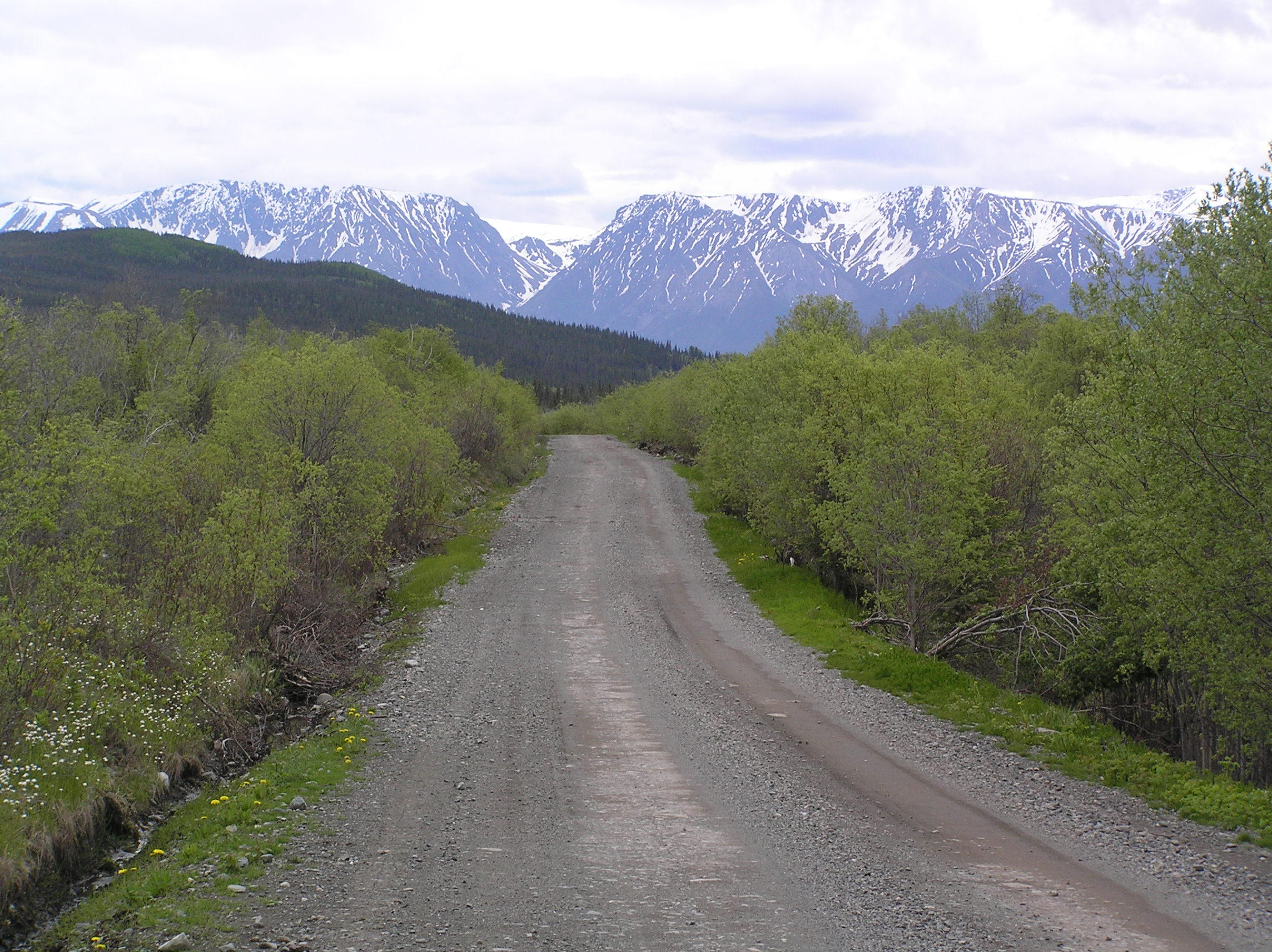
Drive McCarthy Road
Once the gateway to tremendous fortunes from mining copper and gold, McCarthy Road is now the gateway to spectacular scenery, vast wilderness, and adventure. For those willing to leave the pavement behind, this unpaved 60 mile road provides access to many natural and historic wonders of our largest park. The road ends at the Kennicott River footbridge, where you can walk, bike or take a shuttle 5 miles further to the Kennecott Mines National Historic Landmark.
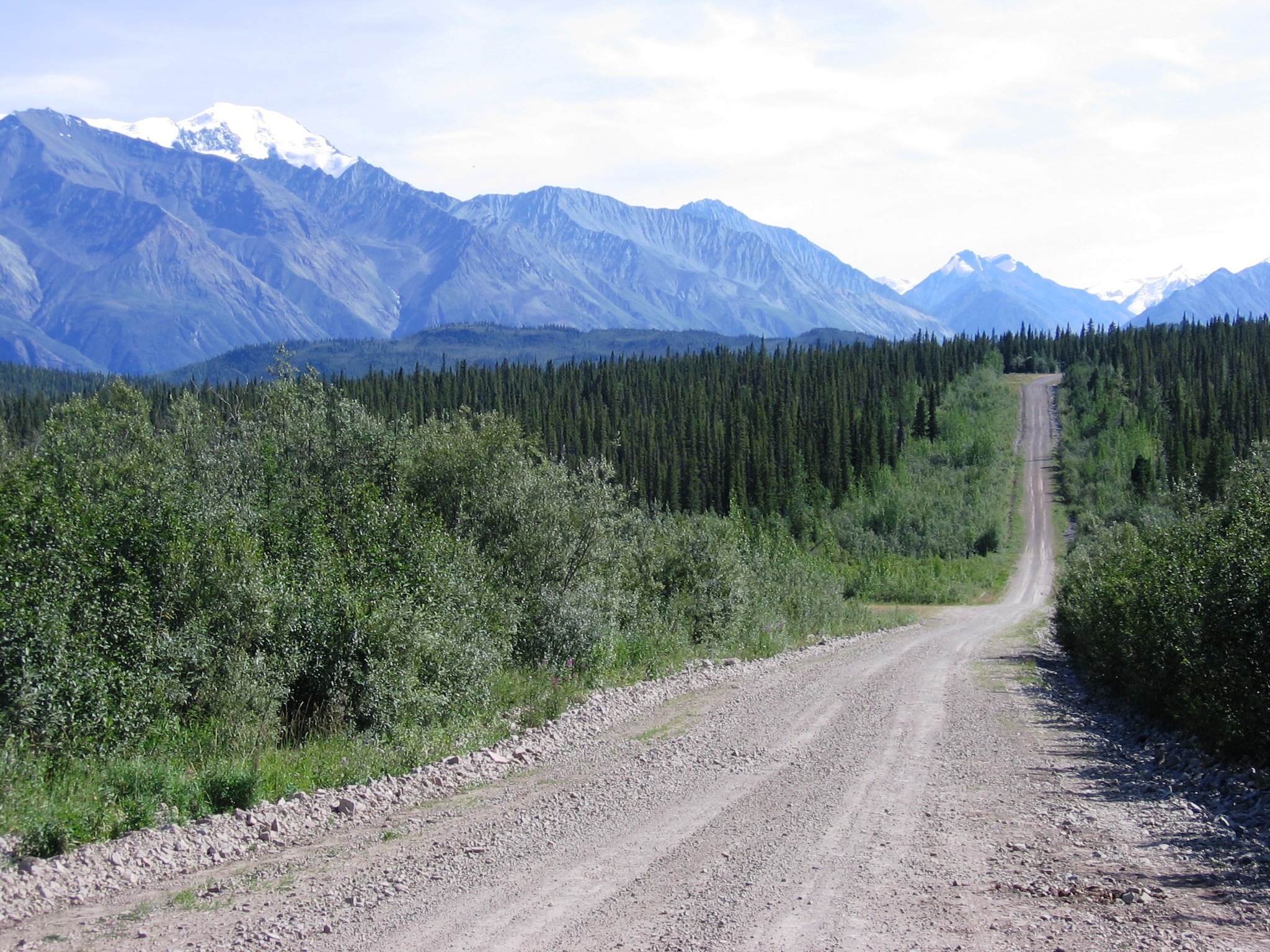
Drive Nabesna Road
The unpaved Nabesna Road stretches for 42 scenic miles, and it is much the same today as it was when it was built back in 1934 to transport gold from the mines. Generally, the Nabesna Road is passable by any two-wheel drive vehicle. But especially after it has rained, stream crossings may become impassable. At times, the road is rough and you may need a four wheel drive vehicle. Please be cautious and take care, as there may be uneven surfaces, potholes, and washouts present.
Hike the Boreal Forest Trail around the visitor center in Copper Center
Short walking trails with interpretive wayside signs around the Visitor Center complex in Copper Center, including the Exhibit Hall. Boreal Forest Trail: 1/2 mile loop, easy, partly paved, partly gravel, no elevation change. Copper River Bluff Trail: 1/2 mile loop, moderately difficult, gravel, some elevation change with a few steep sections. Valdez Trail: short segment of a historic trail, easy, gravel, no elevation change. Turn around at private property gate to return.
Visit Kennecott Mines National Historic Landmark
Located in the center of Wrangell-St. Elias National Park and Preserve, Kennecott is a park within a park. Listed on the National Register of Historic Places in 1978 and designated as a National Historic Landmark in 1986, Kennecott is considered the best remaining example of early 20th Century copper mining. In June 1998, the National Park Service acquired many of the significant buildings and lands of the historic copper mining town of Kennecott and is still in the process of stabilizing many structures.
Yakutat - fly or sail to the coastal area of the park.
Accessible only by plane or boat, this area encompasses the park's coastal region, with 155 miles of little-known coastline. Here, huge mountains, enormous glaciers, and temperate rainforest meet the ocean. Visitor services are only found in town of Yakutat, which is a plane or boat ride away from Anchorage. A wide variety of outdoor enthusiasts come here to hike the beaches, float or fish the rivers, surf ocean waves, explore the bays, view glaciers, climb mountains and enjoy the wilderness.