Be advised that the NPS has issued alerts for this park.
Burn Operation Taking Place Week of September 22, 2025
Weather permitting, park firefighters will conduct a burn treatment to reduce the accumulation of hazardous fuels around Shenandoah's Headquarters infrastructure week of September 22, 2025. There will be noticeable smoke in the area.
Panorama Comfort Station Temporarily Out of Service
Due to a water line break, the restrooms at Panorama Comfort Station are out of service until repairs can be made. Portable toilets are in place for public use.
Necessary Upgrades Underway at Dickey Ridge Visitor Center in September
For visitor safety, please avoid the construction area and follow all signage and fencing. Visitor center operations will not be impacted.
Parking at Boundary Access Areas
Visitors are reminded to park in designated parking areas when accessing the park via boundary trailheads. Parking in unauthorized locations may result in your vehicle being towed at the owner's expense.
Shenandoah National Park Moves to Fully Cashless Fee Collection July 1
On July 1, 2025, the park transitioned to a fully cashless system at our fee entrance stations. Only credit cards, debit cards, or mobile payments will be accepted.
Charging Stations are Currently Unavailable
The charging stations at Skyland are currently out of service.
Get Skyline Drive Status Updates
Sign up for Shenandoah Alerts by texting SHENALERTS to 888777. Any time there are closures, re-openings, or other important safety-related alerts, subscribers will receive a notification via text. You may unsubscribe at any time.
Skyline Drive Status
Click for more information.
Potential delays during stone wall rehabilitation project
The stone wall that lines Skyline Drive is being rehabilitated between miles 72.8 and 75.7. There will be a single lane closure for the duration of this work, with an established work zone that will be managed by flaggers. Visitors should expect delays.
Ticket Required to Hike Old Rag
March 1 - November 30 those wishing to hike Old Rag are required to obtain a day-use ticket before arriving.
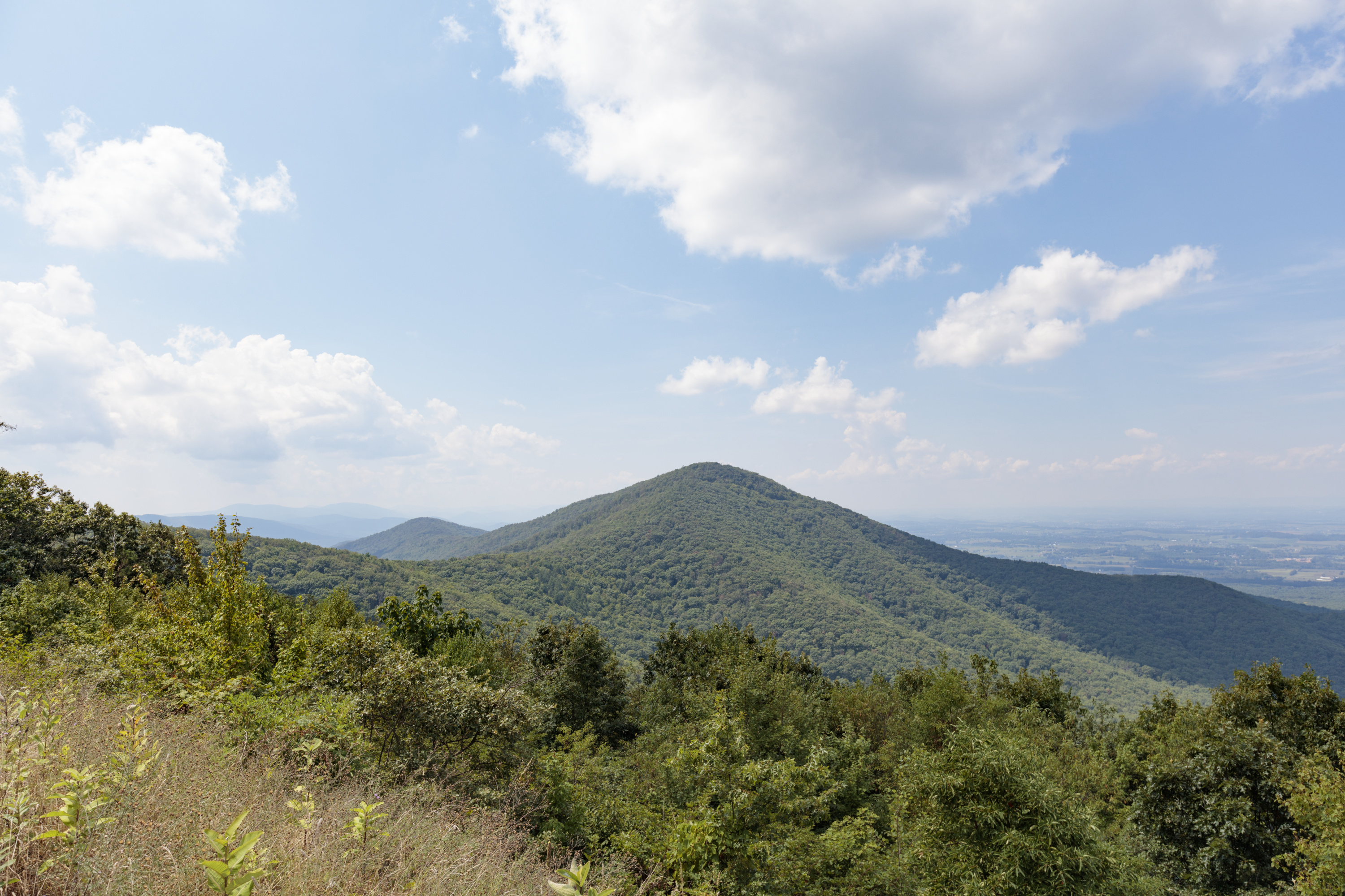
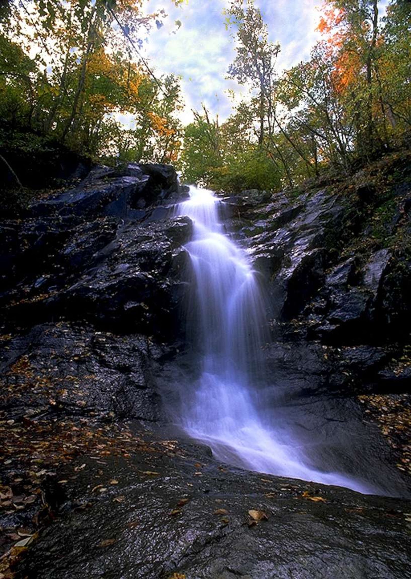
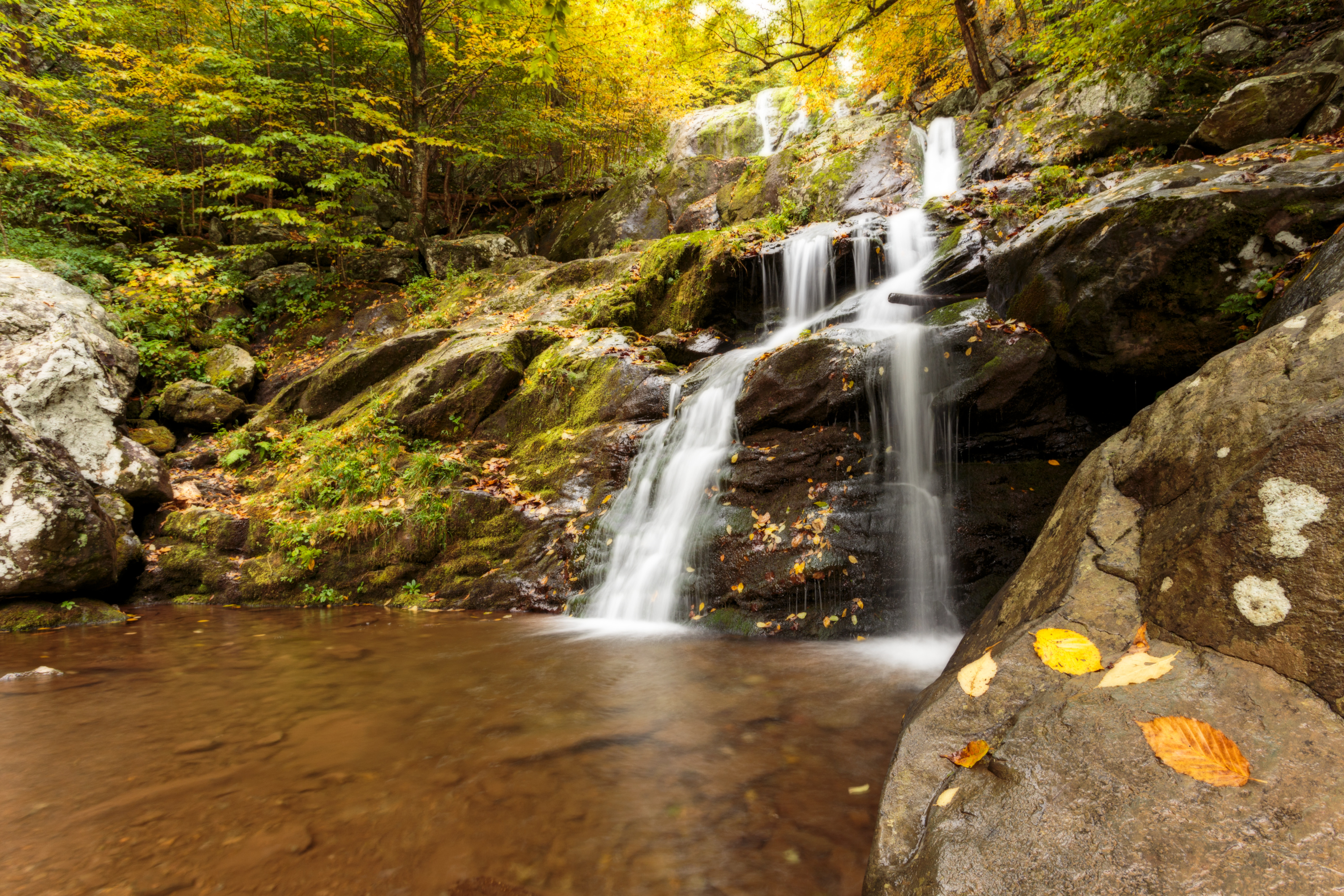
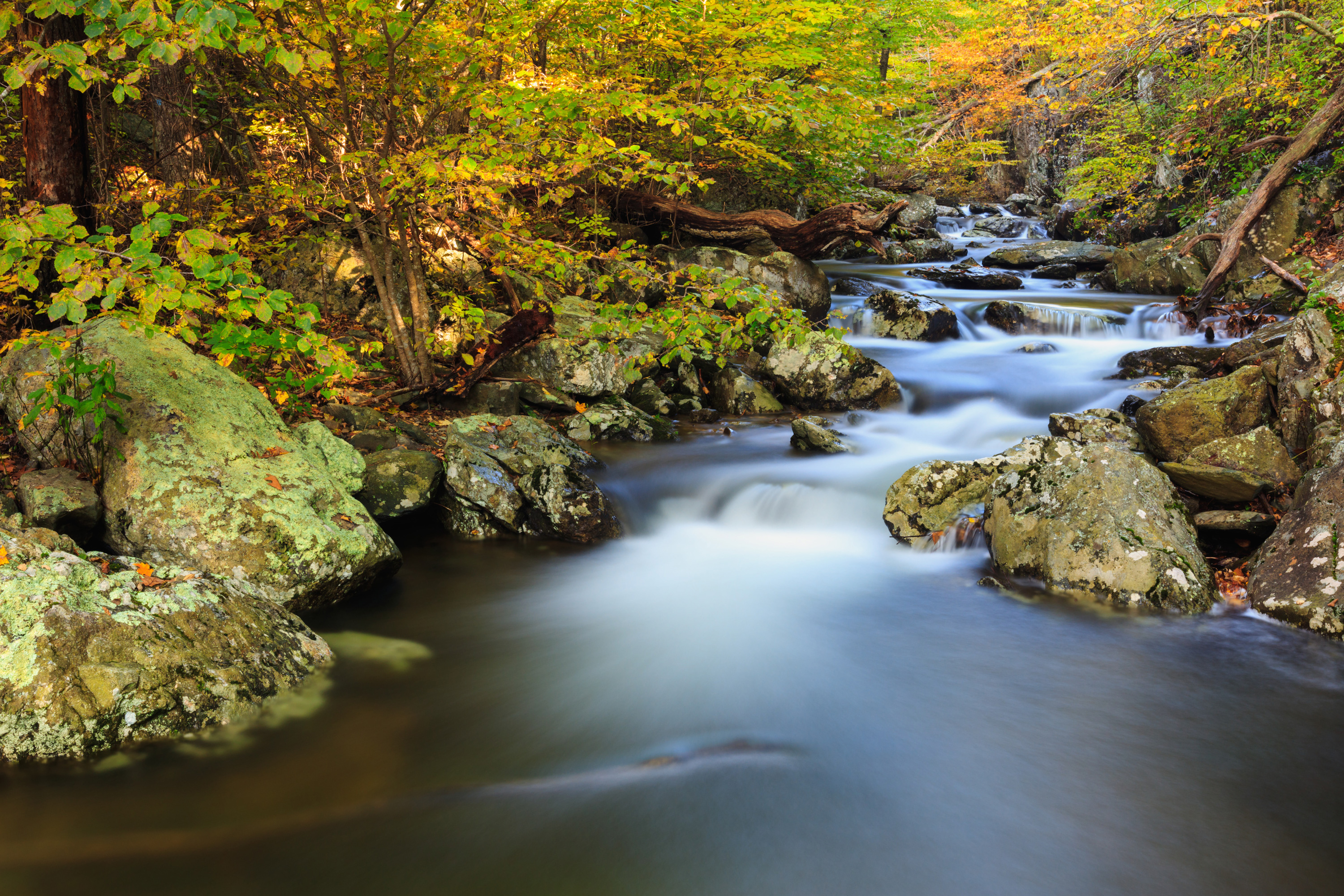
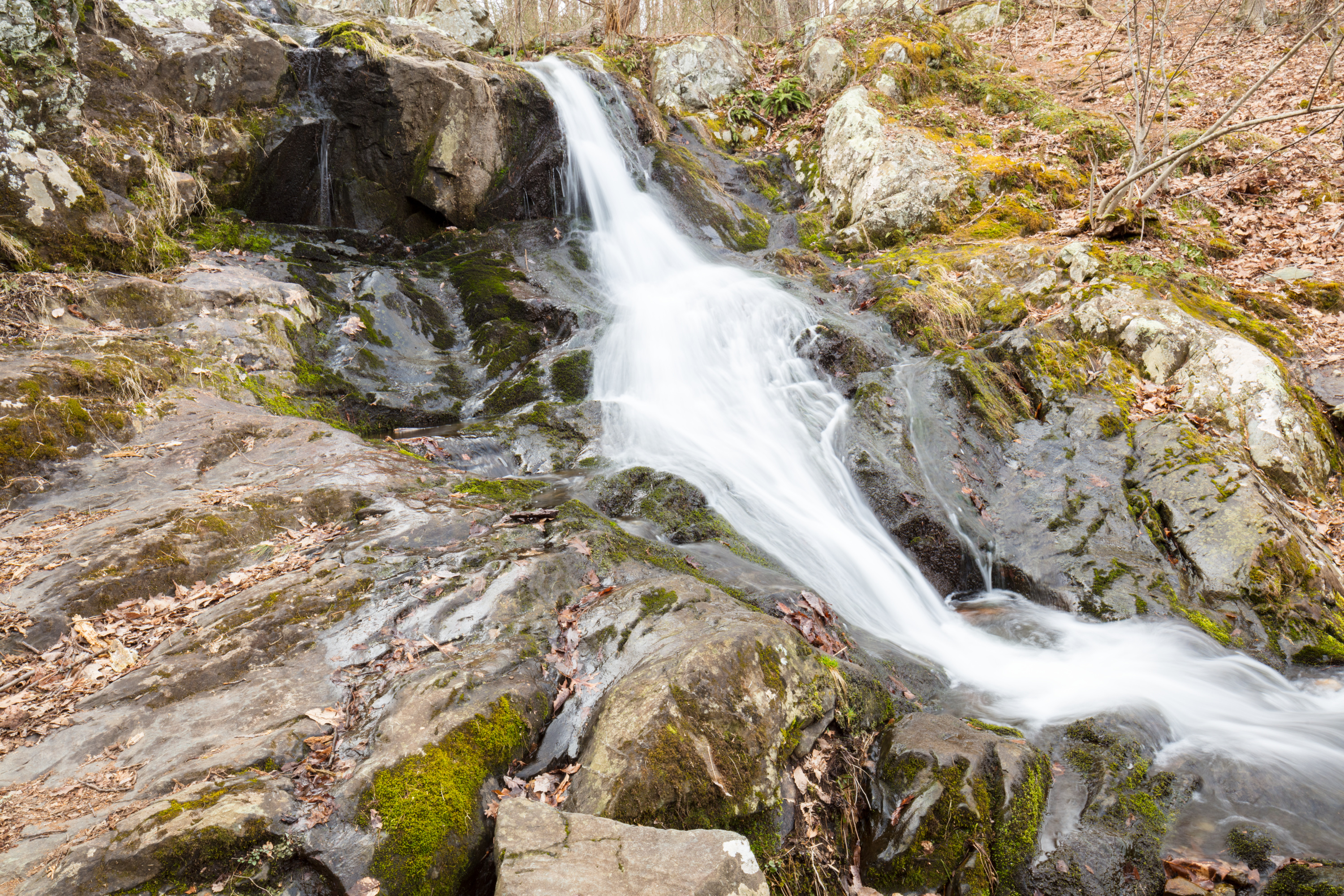
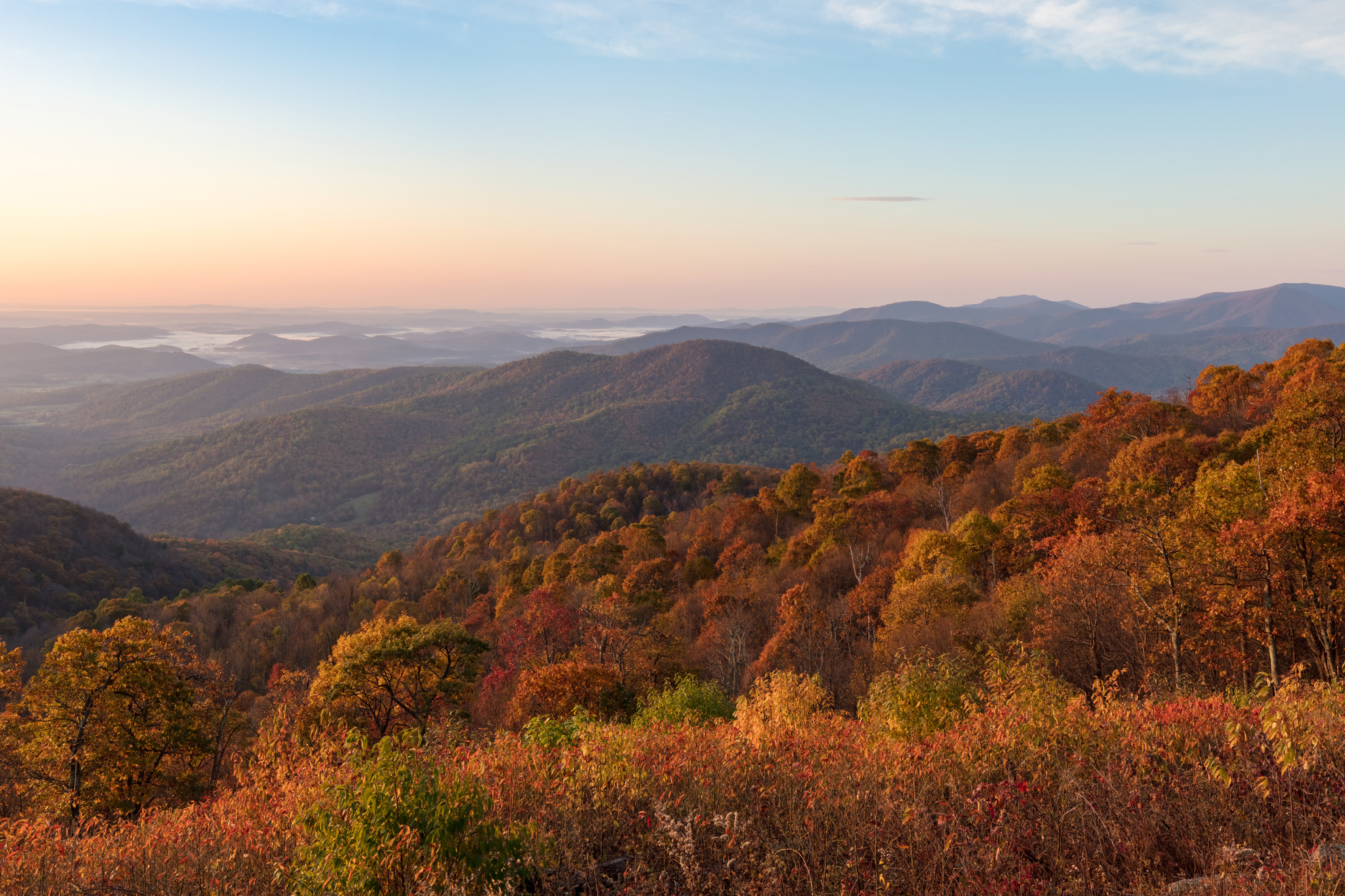
Just 75 miles from the bustle of Washington, D.C., Shenandoah National Park is a land bursting with cascading waterfalls, spectacular vistas, fields of wildflowers, and quiet wooded hollows. With over 200,000 acres of protected lands that are hav...
Unlimited entry for one vehicle and all passengers for seven consecutive days, beginning on the day of purchase. Admits the pass holder and occupants of a single, private non-commercial vehicle.
Entrance - Motorcycle
$25.00
Entry for one motorcycle and one passenger for seven consecutive days, beginning on the day of purchase.
Entrance - Per Person
$15.00
Entry for walk-up or bicycling visitors, when 16 years of age or older (children under 16 are admitted for free). Includes entering the Park by all means other than a private, non-commercial vehicle. A family traveling together shall pay no more than the vehicle fee.
Commercial Entrance - Sedan
$25.00
The total cost is calculated: $25 + $10 per passenger.
Commercial Entrance - Per Person
$10.00
This fee is for commercial use between 1-6 passengers (sedan). The total cost is calculated: $25 for the vehicle + $10 per passenger.
Commercial Entrance - Van
$75.00
Based upon the total capacity of a vehicle that can carry 7-15 passengers, regardless of the actual number of passengers.
Commercial Entrance - Mini-bus
$100.00
Based upon the total capacity of a vehicle that can carry 16-25 passengers, regardless of the actual number of passengers.
Commercial Entrance - Motor Coach
$200.00
Based upon the total capacity of a vehicle that can carry 26 or more passengers, regardless of the actual number of passengers.
Entrance - Education/Academic Groups
$0.00
National Park Service regulations allow school groups and other approved national and international academic institutions to obtain a waiver of Park entrance fees, provided that visit is for educational or scientific purposes, and the resources or facilities that the group intends to use, support those purposes. Request an academic fee waiver through the education section of our website.
Entrance - Non-commercial Groups
$15.00
Fee is calculated per person for anyone 16 years of age or older (children under 16 are admitted for free). Groups will not be charged more than the equivalent commercial group fee.
All sites at Big Meadows Campground are by reservation only. Rangers can make limited reservations on site, but availability is not guaranteed. It is recommended you make your reservation ahead of time. Reservations can be made through Recreation.gov as well as the site map on the campground page. Check the map to see when specific sites are scheduled to be released. Reservable sites will be released in sections: 6 months prior to the date of your arrival - 50% of reservable sites will be released; 2 weeks prior to the date of your arrival - 25% of reservable sites will be released; 4 days prior to the date of your arrival - the remaining 25% of reservable sites will be released. Reservations for Big Meadows Campground can be made online at any time.
A log structure stands on the left side of the road as you enter Big Meadows Campground. There is an overhang supported by wooden beams facing the road. Under the overhang is a kiosk window where a ranger is present during open hours. Next to the kiosk window is a bulletin board with current information.
Lewis Mountain Campground operates on a self-registration, first-come, first-serve basis. There are no reservable sites. Please follow the posted directions to register once arriving at the campground.
Lewis Mountain Campground has multiple one-way roads that travel through the campground and back to the entrance. At the entrance there is a small, brown building with a screen door. There are many posters and brochure racks hanging outside the building. There is also a red emergency phone outside on the left of the building. There is a large brown sign with white lettering: "Select Site Then Register." To the right of the building and across the road is a small, roofed panel with a map on it.
There is a combination of sites offered through reservations and on a first-come, first-served basis at Loft Mountain Campground. Reservations are highly recommended, especially on weekends and holidays. Reservations for many standard sites may be made up to 6 months in advance, with additional sites becoming available 2 weeks prior, and 4 days prior your stay.
A brown board and batten building with an overhang under which is a map, posted information and a dutch door for registration. Rules are on the a sign on the front side of the building: Loft Mountain Campground Regulations; All food, coolers full and empty, scented items and cooking equipment must be stored in you vehicle or in a food storage box whenever you are not using them. Quiet hours are 10:00 p.m. to 6:00 a.m. Camping fees must be paid within one hour of occupying a site. No more than two tents, two vehicles, and six persons per site. Group campsites are available for groups larger than six. Park only on paved parking areas. Fires must be confined to existing fire grates. Do not create additional fire rings. Be sure to completely extinguish fires. Do not feed wildlife. Pets must be on and leash no longer than 6' at all times. Please help keep your campground clean. Check-out time-noon
There is a combination of sites offered through reservations and on a first-come, first-served basis at Mathews Arm Campground. Reservations are highly recommended, especially on weekends and holidays. Reservations for many standard sites may be made up to 6 months in advance, with additional sites becoming available 2 weeks prior, and 4 days prior your stay. Group sites can be reserved up to one year in advance.
The Registration Station at Mathews Arm Campground is a brown building with a small overhang outdoors supported by two pillars. The overhang covers two entrance doors as well as a glass case on the outside wall which contains posters and information. There are also signs regarding campground fees and bear safety. There are overhead lights and a concrete walk area outside the building.
Milam Gap Parking Area (Mile 52.8) | A fairly level hike that takes you through a former homestead on the famous Appalachian Trail.
The Milam Gap Trailhead panel is a 36 by 54 inch color poster. On the upper left of the panel is a black and white photograph of a man in bib overalls standing by a roadside fruit stand selling apples and apple cider. The text reads, "Apple of Their Eye - Apples were a cash crop for the people who lived in what is now Shenandoah National Park. Former residents raised different types of apples - some of which were actually created here - including the Milam, for which this gap is named. The Milam apple was probably developed in an orchard very near where you stand right now." The picture on the bottom left of the panel is a black and white photograph of President Herbert Hoover fly-fishing in one of the mountain streams that ran through his property. The text reads, "Fit for a President. The Park's clear mountain streams host a variety of fish species, including native eastern brook trout. Fly-fisherman and U.S. President Herbert Hoover chose a site two miles east of here, at the headwaters of the Rapidan River, for his weekend retreat because of its proximity to these streams and their trout. Rapidan Camp was built in 1929 and gave the 31st President the perfect place to practice his favorite pastime." The top right of the panel is a 20 by 20 inch topographic map of the hike to Rapidan Camp. The trail is marked in yellow with a brown dashed line. The text reads, "Suggested Hikes: Hike #1: Mill Prong - Rapidan Camp. 4-mile round trip, moderate, 2.75 hours hiking time, 870-foot elevation gain, 3 stream crossings. Go left on the Appalachian Trail south, and cross Skyline Drive. Go left on the blue-blazed Mill Prong Trail. Turn right on Mill Prong Horse Trail. Explore the camp, and then retrace your steps to Milam Gap parking." "Hike #2: Appalachian Trail - Tanners Ridge. The trail is marked in purple with a dashed line. 2.1-mile round trip, easiest, 1.5 hours hiking time, 175-foot elevation gain. Go right on the Appalachian Trail north to Tanners Ridge Road. Return by the same route to the starting point." A red text box below the map gives important information that hikers need. The text reads, "Emergency 1-800-732-0911 (cell phone service is unreliable.) Before You Go! Pets must be on a leash at all times. Do not attempt to cross streams in icy conditions or flooding. Be sure you are physically able to complete the hike you've chosen. Take plenty of water - at least a quart per hour Be sure you know your route. Free maps are available at entrance stations, visitors centers, and www.nps.gov/shen. When you return from your hike, check for ticks. Stay on the trail and avoid trampling sensitive vegetation. Be sure someone knows where you are and when to expect your return. Leave what you find. Artifacts are protected by law. Filter or treat water from streams before drinking. Please respect family cemeteries."
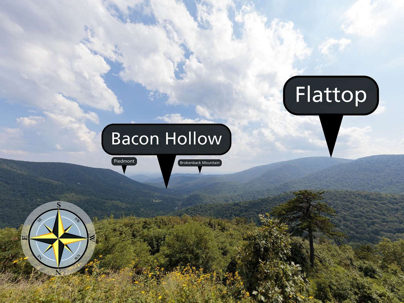
Facing south from an elevation of 2,455 ft (748 m), the view from Bacon Hollow Overlook stretches out over a broad hollow that descends to the Piedmont in the distance. The Piedmont is the central region of Virginia between the Blue Ridge Mountains and the Coastal Plains. Literally meaning foothills, the Piedmont region is known for its rolling hills and rural character.
The view from this overlook faces south. Over the vegetation on the ledge of the overlook is Bacon Hollow, located at the intersection of where two ridges are descending. To the right is the larger mountain, Flattop. Following the ridge along Flattop and beyond Bacon Hollow the descent ends at the flat land of the Piedmont region.
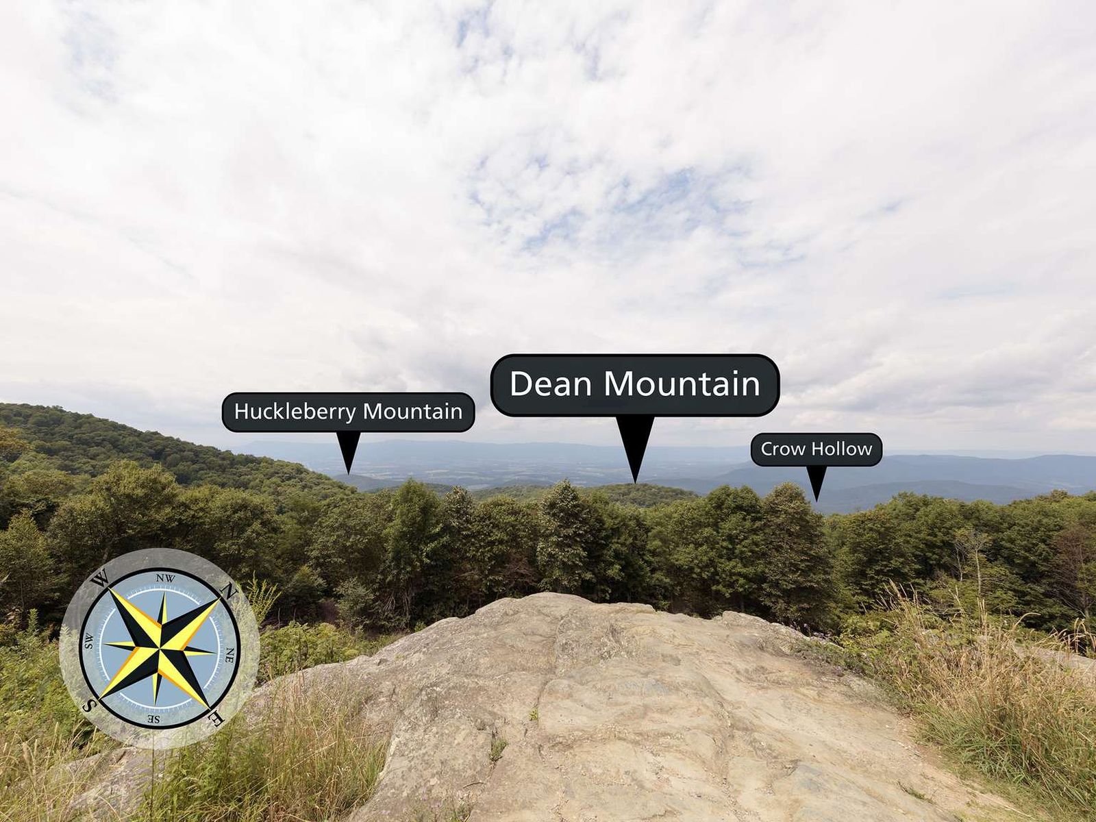
Facing northwest from an elevation of 3,345 ft (1,019 m), the view from Baldface Mountain Overlook glimpses into the Shenandoah Valley below. You are atop a slope of Baldface Mountain. The peak is on the opposite side of the Skyline Drive to the northeast.
This overlook faces northwest. There is a rocky ledge that juts out over a slope. The slope descends into a line of trees with a view of the Shenandoah Valley beyond. From the left is Huckleberry Mountain and Dean Mountain. From the right the Blue Ridge Mountains descend into the valley below. Crow Hollow is on the right. The long ridge of Massanutten is Mountain spans along the horizon.
Beagle Gap contains a small parking lot with portable toilets and access to the Appalachian Trail.
An open area free of the forest canopy cover with a dirt parking lot to the east side of the road. There are portable toilets at the north end of the parking lot in front of a handicap parking space.
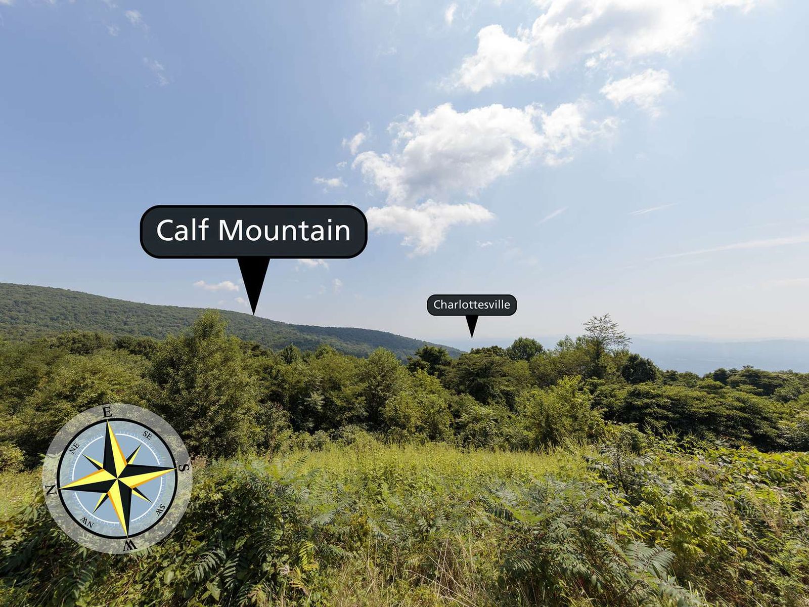
Facing east from an elevation of 2,495 ft (760 m), the view from Beagle Gap Overlook stretches outside of Shenandoah National Park to the Piedmont region of Virginia. Calf Mountain is the long ridge from the left descending down to the center of the view. If you travelled in a south-eastern direction the first urban center you would hit is the town of Charlottesville, Virginia.
The view from this overlook looks east. There is a meadow leading to a line of trees. Beyond the trees is a mountain on the left descending to the right. This is Calf Mountain. In the distance the view drops off to a flat area known as the Piedmont region of Virginia.
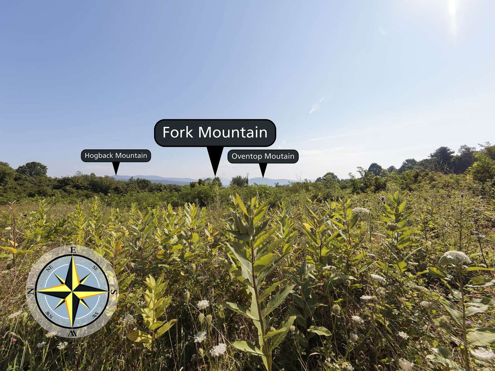
Beahms Gap sits at an elevation of 2,485 ft (757 m). During the early years of Shenandoah National Park, there was a 360 degree view from this location, created by clearing the land around Skyline Drive. Over time, trees have grown back and there is no view of the Shenandoah Valley from the Beahms Gap parking lot. If you cross the Skyline Drive on a clear day, you can see Hogback Mountain, Fork Mountain, and Oventop Mountain.
The Beahms Gap Orientation Shelter is next to the parking area. The only view from this overlook is looking east, from across Skyline Dive. This view looks over a field with a line of trees in the distance. Further in the distance are the peaks of a few mountains. From the left is Hogback Mountain, Fork Mountain, and Oventop Mountain. There is an orientation shelter at this overlook. The orientation shelter is a small roof supported by six brown beams. The beams are frames for six upright 36 inch by 54 inch panels in glass enclosures. Panel 1. Bulletin Board Bulletin boards contain seasonal information. Panel 2. Park Map This graphic is divided into two columns, the left has text and images and the right has a map. On the right column, title text reads, "Welcome to Shenandoah National Park." Below the title is a color photograph of a man standing atop a rock outcrop and looking to the mountains in the distance on a sunny day. Layered on the image is the quote "...for the recreation and the re-creation they shall find here." -President Franklin Roosevelt, Shenandoah's Dedication." Text below the image reads, "Shenandoah National Park was established in 1935 to bring the western national park experience to the urban east. Here, within a few hours' drive of millions, you will find "recreation and re-creation." Experience the wonder of nature, the power of shared heritage, and the inspiration that is the future of our national parks." Below there is the subheading "Shenandoah Highlights," and the text "- Skyline Drive - 105 miles of beauty. Please observe the 35 mph speed limit to see it all safely. - 75 Overlooks - Spectacular views of the Shenandoah Valley and Virginia Piedmont. - 500 Miles of Trails - Beautiful waterfalls, quiet forests, and mountain summits are just a hike away. - Visitor Centers - Films, exhibits, and Ranger-led walks and talks tell Shenandoah's stories." The map to the right shows the boundaries of, driving route through, and highlights in Shenandoah National Park. The map area is 30 miles wide by 150 miles long. Shenandoah National Park is shaded green. Highlights include entrance stations, visitor centers, campgrounds, lodging, restrooms, food services, and trailheads. At the bottom of the map is the park emergency number: (800) 732-0911. At the top and bottom of the graphic are black bars. The black bar at the top has the text, "Shenandoah National Park," to the left, and "National Park Service, U.S. Department of the Interior," on the right with the National Park Service arrowhead logo to the far right. The lower black bar has the Leave No Trace logo on the left with the text "Leave No Trace Principe #6, Respect Wildlife," and on the right the text "www.nps.gov/shen." Panel 3. Spring/Summer The graphic is split into two horizontal sections with text and graphics in rectangles. The top section has the title, "Spring" with the subtitle "Renewal." The rectangle is split vertically. The left side contains three color photographs with text descriptions. The first image is white flowers with four petals labeled "Flowering Dogwood," and the accompanying text, "Dogwood blossoms are well-known messengers of spring, but this understory tree has other jobs, too - like providing food and shelter." The second image shows a mother deer and two fawns walking in high grasses labeled "White-tailed Deer" with the accompanying text "White-tailed deer hide their fawns under the dogwood's low-hanging branches and feed on its tender shoots, buds, and later, berries." The third image shows a dark blue bird with black tail feathers labeled "Indigo Bunting," and the accompanying text "Indigo buntings often build their nests in dogwood trees and line them with deer hair. Birds love the berries' high fat content, a great trade-off for the dogwood, since its seeds are spread by those who eat them, ensuring the dogwood's renewal." The right side of the top panel contains the text, "From the moment the first plant pushes up through the forest floor beginning its annual growth cycle, spring is renewal. Hungry black bears come out of their dens with winter-born cubs. Migratory birds return, butterflies emerge, and wildflowers herald the season. Every life, new and old, depends on another." There are nine color photographs under this text arranged in a 3 by 3 square. From the top left they are: a bush with clumps of white flowers labeled "Mountain Laurel," a butterfly with white and yellow markings and blue tips on the wings labeled "Eastern Tiger Swallowtail," round mounds of fungus growing out of the forest floor labeled "Morel Mushrooms" a small curled up salamander labeled "Red-backed Salamander," a bird with yellow, black, and white markings labeled "Chestnut-sided Warbler," a single white flower with three petals and large green leaves labeled "Large-flowered Trillium," a light brown toad on the ground labeled "Spring Pepper," a set of three yellow and red bell shaped flowers labeled "Wild Columbine"
Bearfence Parking Area (mile 56.4) | Pets are not allowed on this hike. An exhilarating rock scramble leads to a magnificent 360-degree view of the Virginia Piedmont and Shenandoah Valley.
The Bearfence Trailhead panel is 36" by 54." On the upper left of the panel is photograph of a man climbing up through a rock scramble toward the blue sky. The text reads, "Rock of Ages - You'll have to navigate the boulders and jagged, nearly vertical rocks on Bearfence by using your feet and hands. The rocks are mostly greenstone - originally volcanic lava, but with millions of years of compression, metamorphosed into the gray-green rock you see today. Over time, freezing, thawing, and trees taking root in the rock will break these boulders down into soil." The picture on the bottom left of the panel is a photograph of stonecrop growing between the rocks and lichens growing on the rocks. The text reads, "Rocky Top - Even on the rockiest mountaintop there is life. Part fungus and part algae, lichens grow on rocks and are indicators of clean air. Mosses, saxifrage, and stonecrop can also take root on and in between rocks, needing only the smallest amount of soil - even using their own decaying matter - to grow. Black birch trees can send down long roots to find moisture and nutrition in the thinnest soil. They seem to grow right out of the rock! The plant life that grows on and around rocks is tough but delicate. Please tread lightly." The top right of the panel is a 20 by 20 inch topographic map of the hike to Bearfence. The trail is marked in yellow with a brown dashed line. The text reads, "Suggested Hikes: Hike #1: Bearfence Rock Scramble - 1-mile lariat, moderate, 1 hour hiking time, 311-foot elevation gain. This hike includes a rock scramble, which means you'll be pulling yourself up, over, and between boulders, using your hands and feet. Cross Skyline Drive and climb the stairs up the bank. At the trail post, continue straight ahead on Bearfence Loop Trail. After the rock scramble, turn right onto the connector trail. Go right on the Appalachian Trail north. At the intersection, turn left and return to the parking lot." "Hike #2: Bearfence Viewpoint - No Rock Scramble - The trail is marked in purple with a dashed line. 1.1-mile round trip, easiest, .75 hour hiking time, 305-foot elevation gain. This route eliminates the rock scramble from the hike. Cross Skyline Drive and climb the stairs up the bank. At the trail post, turn right onto the Appalachian Trail (A.T.) south. Go left on the connector trail, then turn right on Bearfence Loop Trail. You'll see the viewpoint on your right. Retrace your steps to the starting point." A red text box below the map gives important information that hikers need. The text reads, "Emergency 1-800-732-0911 (cell phone service is unreliable.) Before You Go! Hike #1 includes a rock scramble; do not attempt in wet or icy conditions. Hike #1 may not be suitable for those with a fear of heights. Pets are not allowed on Bearfence Loop Trail. Where allowed, pets must be on a leash at all times. Be sure you are physically able to complete the hike you've chosen. Take plenty of water - at least a quart per hour. Be sure you know your route. Free maps are available at entrance stations, visitors centers, and www.nps.gov/shen Stay on the trail and avoid trampling sensitive vegetation. When you return from your hike, check for ticks. Be sure someone knows where you are and when to expect your return.
Bearfence Parking Area (mile 56.4) | Pets are not allowed on this hike. This route takes you to a 180-degree view of the Shenandoah Valley without a rock scramble.
The Bearfence Trailhead panel is 36" by 54." On the upper left of the panel is photograph of a man climbing up through a rock scramble toward the blue sky. The text reads, "Rock of Ages - You'll have to navigate the boulders and jagged, nearly vertical rocks on Bearfence by using your feet and hands. The rocks are mostly greenstone - originally volcanic lava, but with millions of years of compression, metamorphosed into the gray-green rock you see today. Over time, freezing, thawing, and trees taking root in the rock will break these boulders down into soil." The picture on the bottom left of the panel is a photograph of stonecrop growing between the rocks and lichens growing on the rocks. The text reads, "Rocky Top - Even on the rockiest mountaintop there is life. Part fungus and part algae, lichens grow on rocks and are indicators of clean air. Mosses, saxifrage, and stonecrop can also take root on and in between rocks, needing only the smallest amount of soil - even using their own decaying matter - to grow. Black birch trees can send down long roots to find moisture and nutrition in the thinnest soil. They seem to grow right out of the rock! The plant life that grows on and around rocks is tough but delicate. Please tread lightly." The top right of the panel is a 20 by 20 inch topographic map of the hike to Bearfence. The trail is marked in yellow with a brown dashed line. The text reads, "Suggested Hikes: Hike #1: Bearfence Rock Scramble - 1-mile lariat, moderate, 1 hour hiking time, 311-foot elevation gain. This hike includes a rock scramble, which means you'll be pulling yourself up, over, and between boulders, using your hands and feet. Cross Skyline Drive and climb the stairs up the bank. At the trail post, continue straight ahead on Bearfence Loop Trail. After the rock scramble, turn right onto the connector trail. Go right on the Appalachian Trail north. At the intersection, turn left and return to the parking lot." "Hike #2: Bearfence Viewpoint - No Rock Scramble - The trail is marked in purple with a dashed line. 1.1-mile round trip, easiest, .75 hour hiking time, 305-foot elevation gain. This route eliminates the rock scramble from the hike. Cross Skyline Drive and climb the stairs up the bank. At the trail post, turn right onto the Appalachian Trail (A.T.) south. Go left on the connector trail, then turn right on Bearfence Loop Trail. You'll see the viewpoint on your right. Retrace your steps to the starting point." A red text box below the map gives important information that hikers need. The text reads, "Emergency 1-800-732-0911 (cell phone service is unreliable.) Before You Go! Hike #1 includes a rock scramble; do not attempt in wet or icy conditions. Hike #1 may not be suitable for those with a fear of heights. Pets are not allowed on Bearfence Loop Trail. Where allowed, pets must be on a leash at all times. Be sure you are physically able to complete the hike you've chosen. Take plenty of water - at least a quart per hour. Be sure you know your route. Free maps are available at entrance stations, visitors centers, and www.nps.gov/shen Stay on the trail and avoid trampling sensitive vegetation. When you return from your hike, check for ticks. Be sure someone knows where you are and when to expect your return.
Facing southwest from an elevation of 2,345 ft (714 m), the view from Beldor Hollow Overlook expands out to the Blue Ridge Mountains with Skyline Drive in the distance.
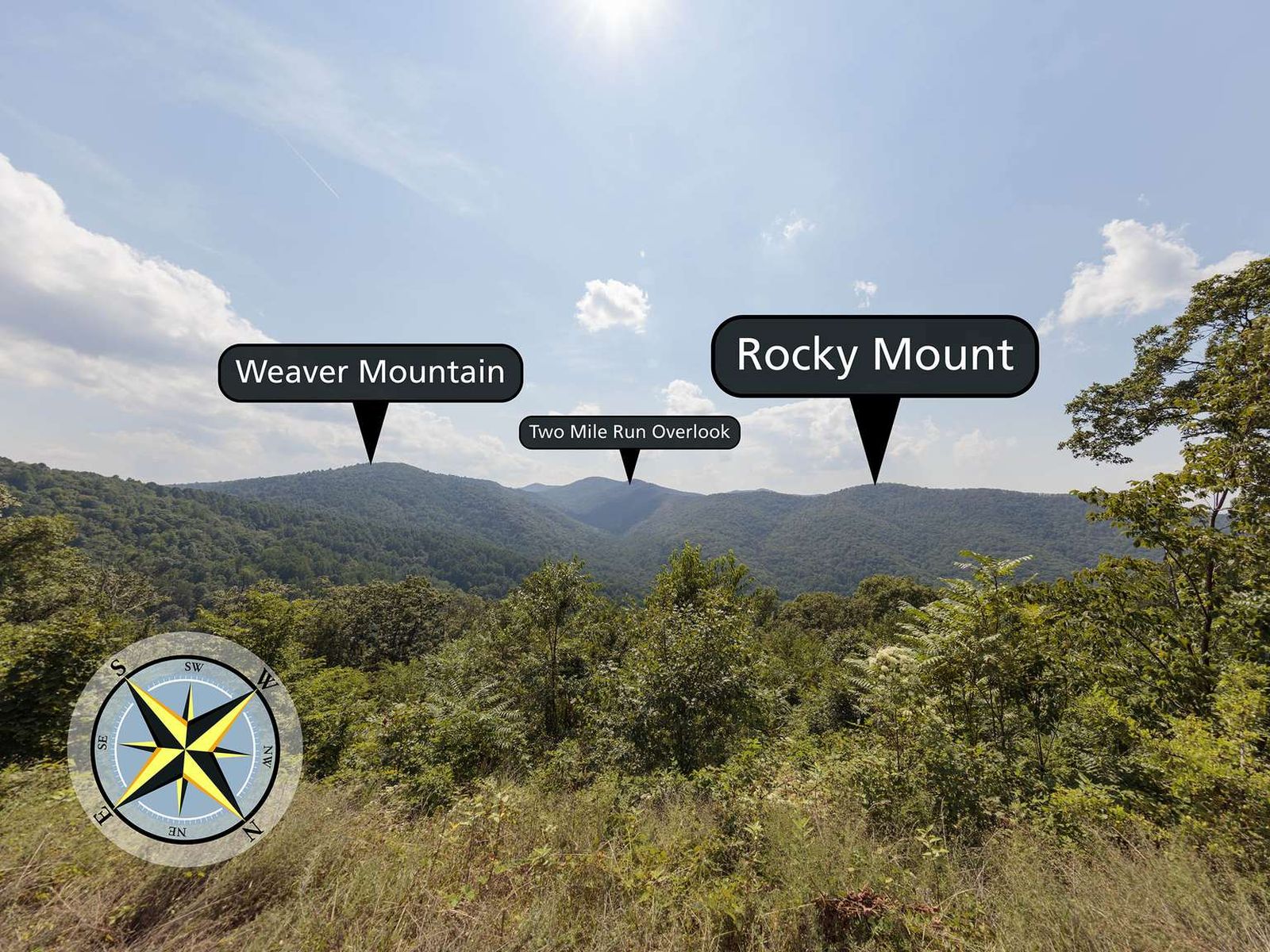
The view from this overlook faces southwest. The view expands over a line of trees out to the ridges of the mountains that make up the horizon. From the left is Weaver Mountain, then along the ridge is a notch at the location of Two Mile Run Overlook, further right is Rocky Mount.
Skyline Drive (mile 51) | Perched on top of a mountain, this high-elevation meadow can come as a bit of a surprise after the miles of lush, green forests that make up most of Shenandoah National Park. A must-see for every visitor, stop by Big Meadows to explore the trails, grab a bite to eat, or talk to a Ranger at Byrd Visitor Center.
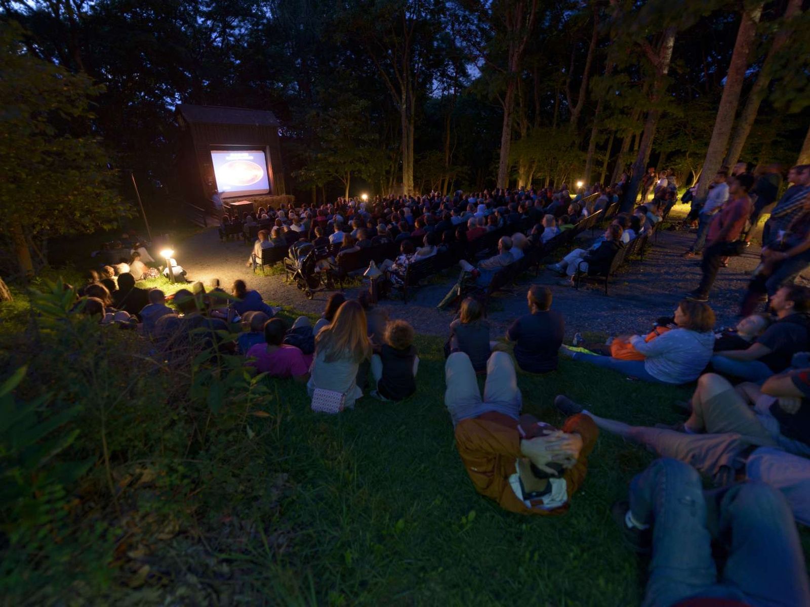
Nothing adds to the National Park experience quite like enjoying an evening ranger program at Big Meadows amphitheater! Come listen to a Park Ranger present a variety of topics that will help you to connect to Shenandoah on a deeper level.
This outdoor amphitheater consists of benches arranged in two columns facing a brown building with a screen for showing presentations. There is a podium in front of the building to the side.
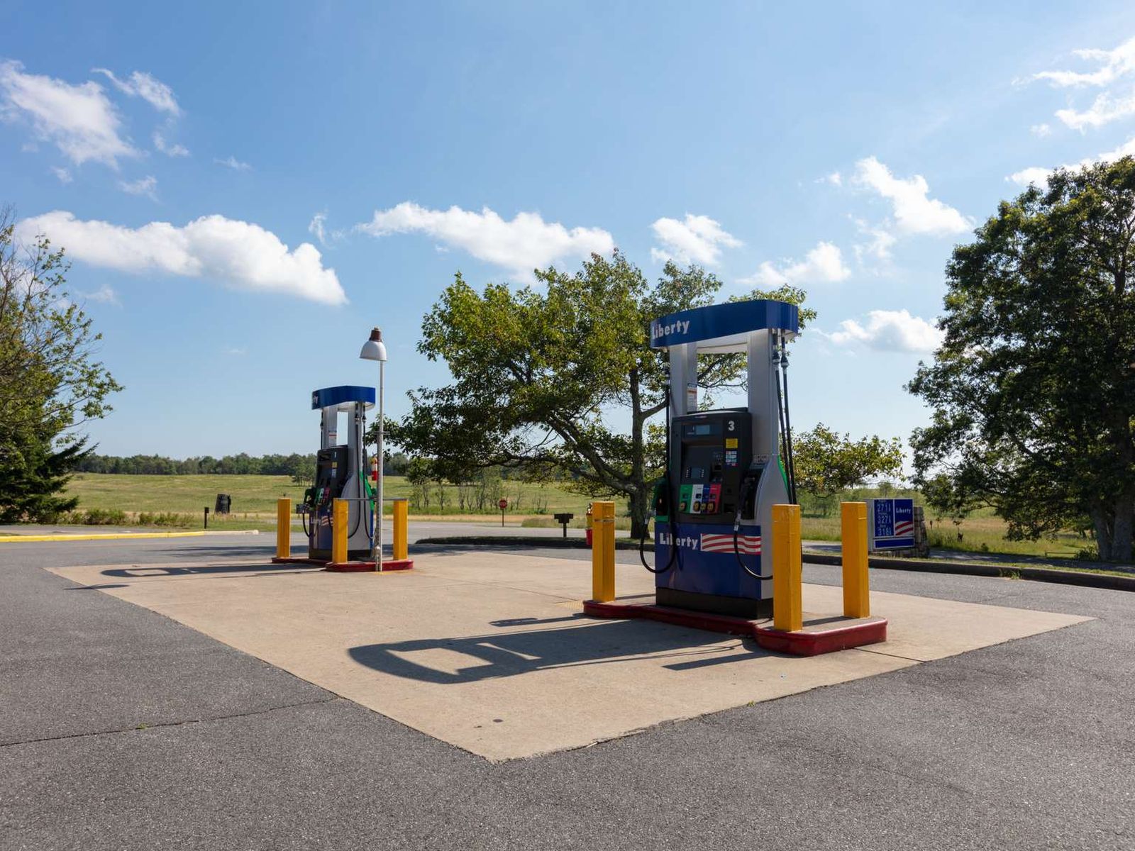
This refueling station is located next to the Big Meadows Wayside. It is the only gas station located within Shenandoah National Park, so be sure to plan accordingly!
Four fuel pumps located on two double sided pump stations next to Big Meadows Wayside.
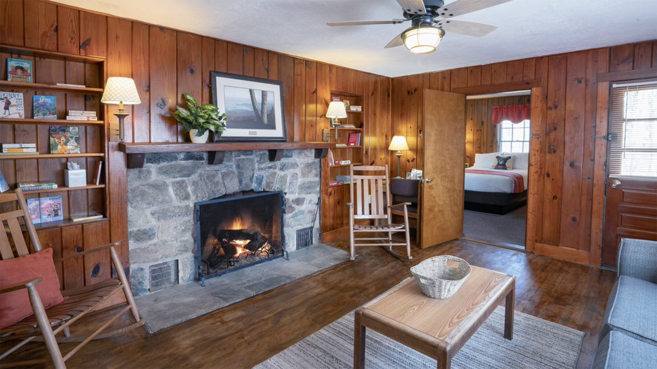
Big Meadows Lodge has accommodations ranging from main lodge rooms to detached small cabins, preferred and traditional rooms, suites, and pet friendly rooms - all located within walking distance of the main lodge building in the popular Big Meadows area. The Spottswood Dining Room, New Market Taproom, and Craft Shop are aso located in the main lodge building.
A rustic building with a stone and brick facade and slanted, shingled roof. A wide paved walkway leads to the entrance, set at an angle facing the parking area. Directly entering the building is a small lobby with the hotel registration desk on the right. A single restroom is immediately on the right. Directly on the left are stairs which lead downwards to more restrooms and the taproom. Further on the left is the dining room entry with a check-in desk. Straight head through a doorway is a large room with many seating areas for relaxation, including rocking chairs in front of large windows. Games and puzzles are available. An outdoor balcony is accessible through a door in the back of the room.
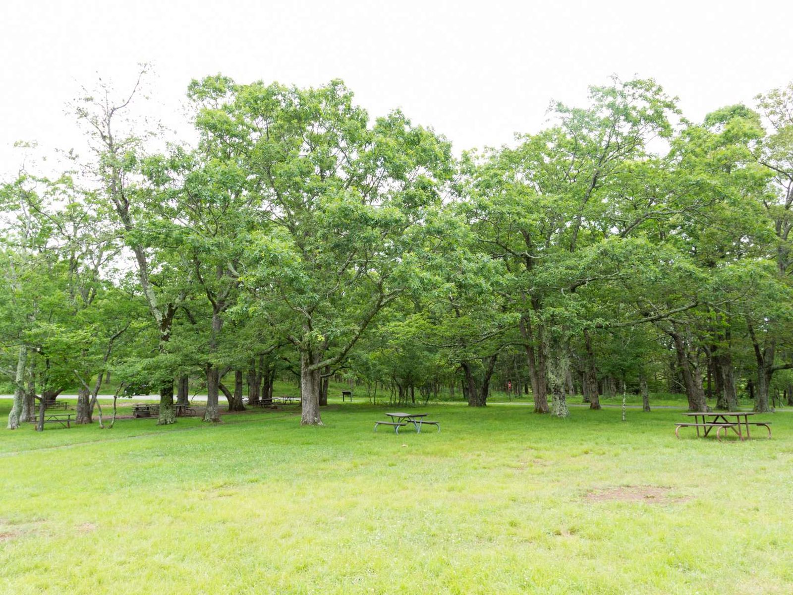
Located next to the Big Meadows Campground, Big Meadows Picnic Grounds provides an open space to relax, complete with picnic tables and grills.
The road at Big Meadows Picnic Ground is a one way loop. Inside the loop is a field with scattered picnic tables and grills. There is a restroom building in the center.
Big Meadows Wayside offers a varied menu of regional favorites available for carry-out or sit down dining. The Grab 'n Go kiosk inside offers sandwiches, salads, pastries, snacks and drinks to go. Groceries, gifts, and camping supplies are also available.
The Big Meadows Wayside is a rustic, one story, wood paneled building with eye-level green-framed windows lining the sides of the building. There is a paved walkway that leads to the building from the parking lot. A right turn down the sidewalk will lead around the side of the building to the restrooms. Go straight on the sidewalk and through glass double doors with wood framing to enter the wayside. The entrance of the wayside is a narrow hallway leading to three sections that offer different services. To the left is a gift shop. Straight ahead is a camp store. There are two registers for these stores, one left of the entrance hallway and one straight ahead of the entrance to the right, before the entrance to the camp store. To the right of the entrance is the dining area. The first part of the dining area is an open space where you can order food from two windows. You can access this area from the main entrance hallway of the wayside. Once you turn right into this open area, there will be a room on the right that is a seating area for eating in.
Facing northwest from an elevation of 2,860 ft (871 m), at Big Run Overlook you will look out toward the Shenandoah Valley below. Unfortunately, the view at this overlook is obstructed by overgrowth most of the year, making it difficult to see the mountains and valley beyond.
The view from this overlook faces northwest. There is a dense line of shrubs and other vegetation interfering with this view for much of the year. Beyond the vegetation in the distance is Rockytop Mountain. Further in the distance and only on the right of the view is Massanutten Mountain.
Blackrock Parking Area (mile 84.4) | A short hike to a viewpoint on top of a rocky talus slope with incredible views of the Shenandoah Valley, Massanutten Mountain, and beyond. This hike is also a designated TRACK Trail, featuring a self-guided brochure designed for kids.
The Upper Blackrock Summit Trailhead exhibit is a 36 by 54 inch color panel. On the upper left of the panel is a photograph taken skyward up the talus slope toward the sky. The text reads, "An Ocean Preserved - The exposed rocks of Blackrock formed the seabed of the Iapetus Ocean, an ancient body of water that predates the Appalachian Mountains. The geological forces that created the mountains changed the seabed into solid quartzite rock. You can see the layers of sand and quartzite on the rocks. Blackrock is still changing. Weathering has caused what was once a cliff to crumble into a talus slope, a river of moving rocks. Water, ice, and roots break the rocks into even smaller pieces that slide downhill. Eventually the rocks will have settled enough that plants can grow and Blackrock will look like other forested mountainsides. The photograph on the bottom left of the panel is a close-up of a table mountain pine cone lying on the forest floor. The text reads, "A Forest Renewed - Around Blackrock you might notice burn scars here and there. You might also see new oak and table mountain pine seedlings reaching for the sun. It's hard to see the relationship between the two - fire and these seedlings - but actually we wouldn't have one without the other! The Blackrock area was the site of a prescribed burn in 2008. Shenandoah fire managers were concerned that, because the area had not burned for many years, the thick mountain laurel was choking out native oaks and pines. A carefully planned fire helped clear the brush, open the forest canopy, and regenerate important species. You Can Help - The popularity of the cliffs makes your care even more important. Constant trampling can endanger the fragile vegetation. Please stay on the trail and avoid stepping on sensitive plants and lichen-covered rocks. The top right of the panel is a 20 by 20 inch topographic map of the hikes to Blackrock Summit. The text reads, "Suggested Hike: Hike: #1 Blackrock Summit (This trail is marked in yellow with a brown dashed line.) 1-mile circuit, easiest, 0.75 hours hiking time, 175-foot elevation gain. Follow the Appalachian Trail (A.T.) south. After a short distance, the trees open up and the A.T. goes around a rocky talus slope. Stay on the A.T. and continue south around the slope. At the intersection, turn left onto the Blackrock Hut Road - Trayfoot Mountain Trail, and follow the trail back to the parking lot. Hike #2: Blackrock Spur Trail & Trayfoot Mountain Trail - (This trail is marked in purple with a dashed line.) 1.6-mile circuit, easiest, 1-hour hiking time, 445-foot elevation gain. Follow the Appalachian Trail (A.T.) south. After a short distance, the trees open up and the A.T. goes around a rocky talus slope. At the trail post, turn right to follow the Blackrock Spur Trail through a boulder field. Continue downhill to the intersection, and turn left onto Trayfoot Mountain Trail. When the trail meets the A.T., it becomes Blackrock Hut Road - Trayfoot Mountain Trail, which will take you back to the starting point. A red text box below the map gives important information that hikers need. The text reads, "Emergency 1-800-732-0911 (cell phone service is unreliable.) Before You Go! Pets must be on a leash at all times. Be sure you are physically able to complete the hike you've chosen. Take plenty of water - at least a quart per hour. Be sure you know your route. Free maps are available at entrance stations, visitors centers, and www.nps.gov/shen Stay on the trail and avoid trampling sensitive vegetation. When you return from your hike, check for ticks. Be sure someone knows where you are and when to expect your return. Be aware that you are in snake habitat.
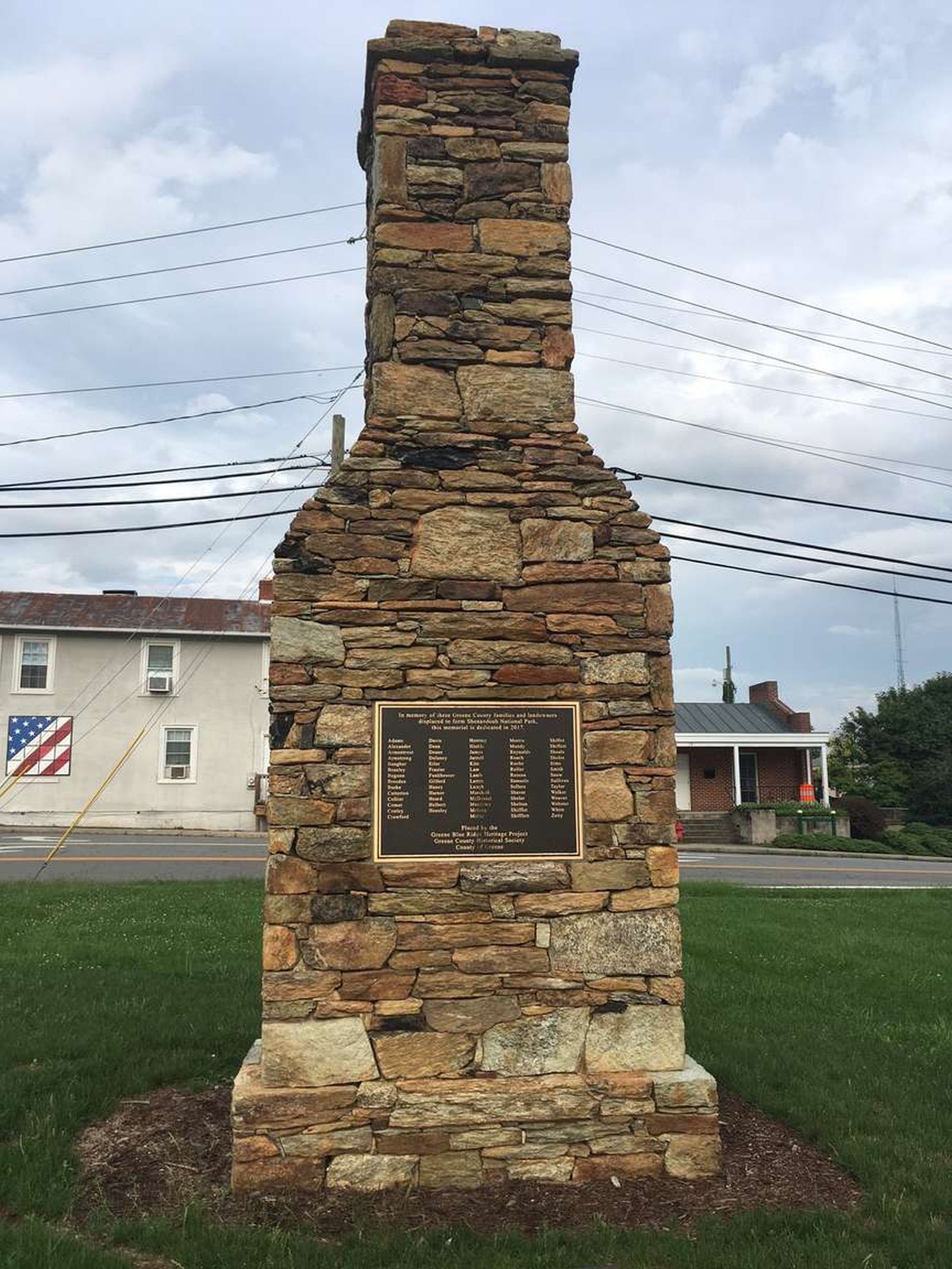
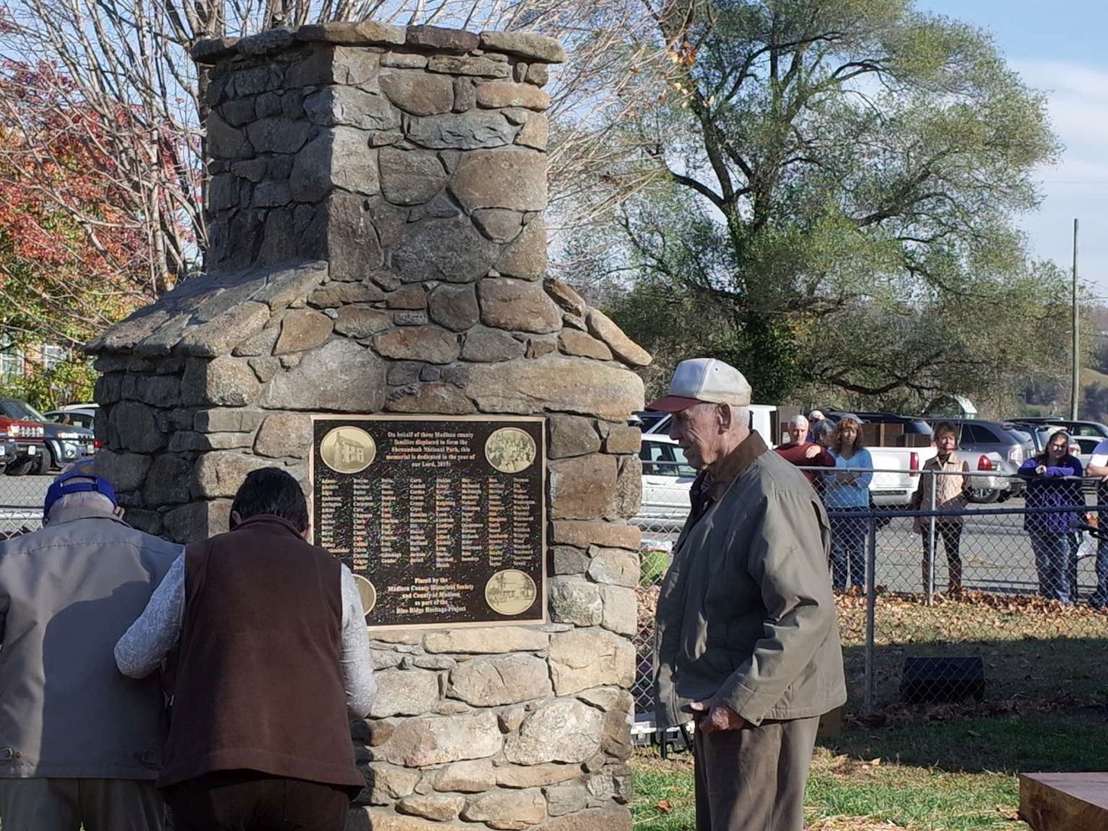
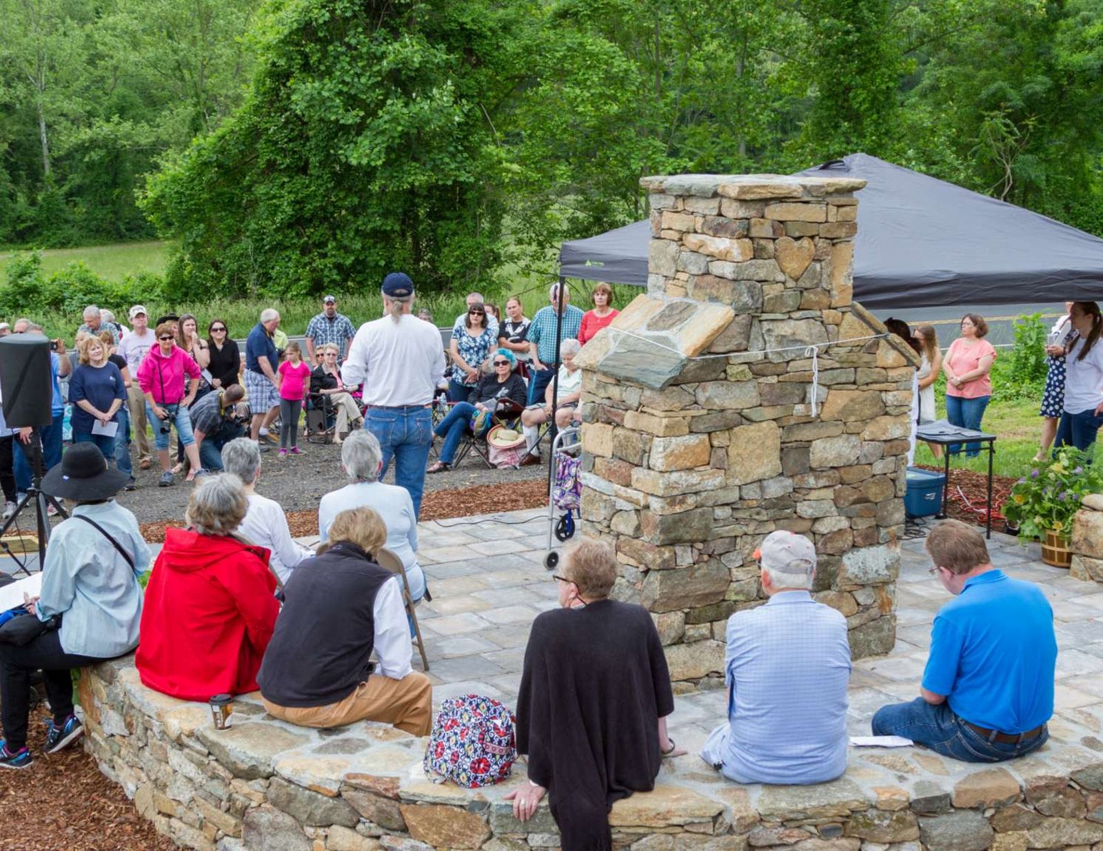
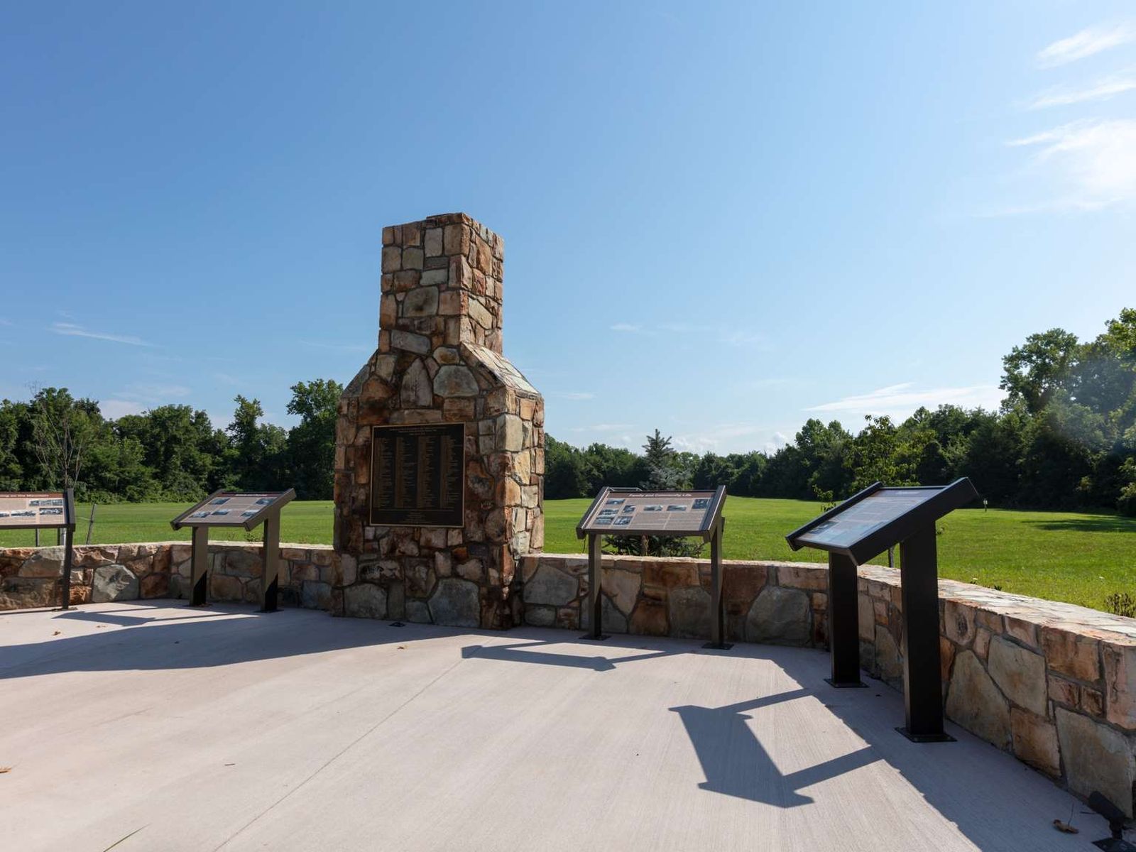
The Blue Ridge Heritage Project is a non-profit organization whose mission is to build monuments to honor the people who were displaced by the creation of Shenandoah National Park. Currently, six of the eight counties from which mountain residents were relocated have monuments: Madison, Page, Rockingham, Greene, Rappahannock, and Albemarle. Warren has a site selected and Augusta is in the planning stages. Most of the monument sites include exhibits about the families. We invi
A large replica sandstone chimney features a bronze plaque bearing the sir names of the families displaced from Greene County.
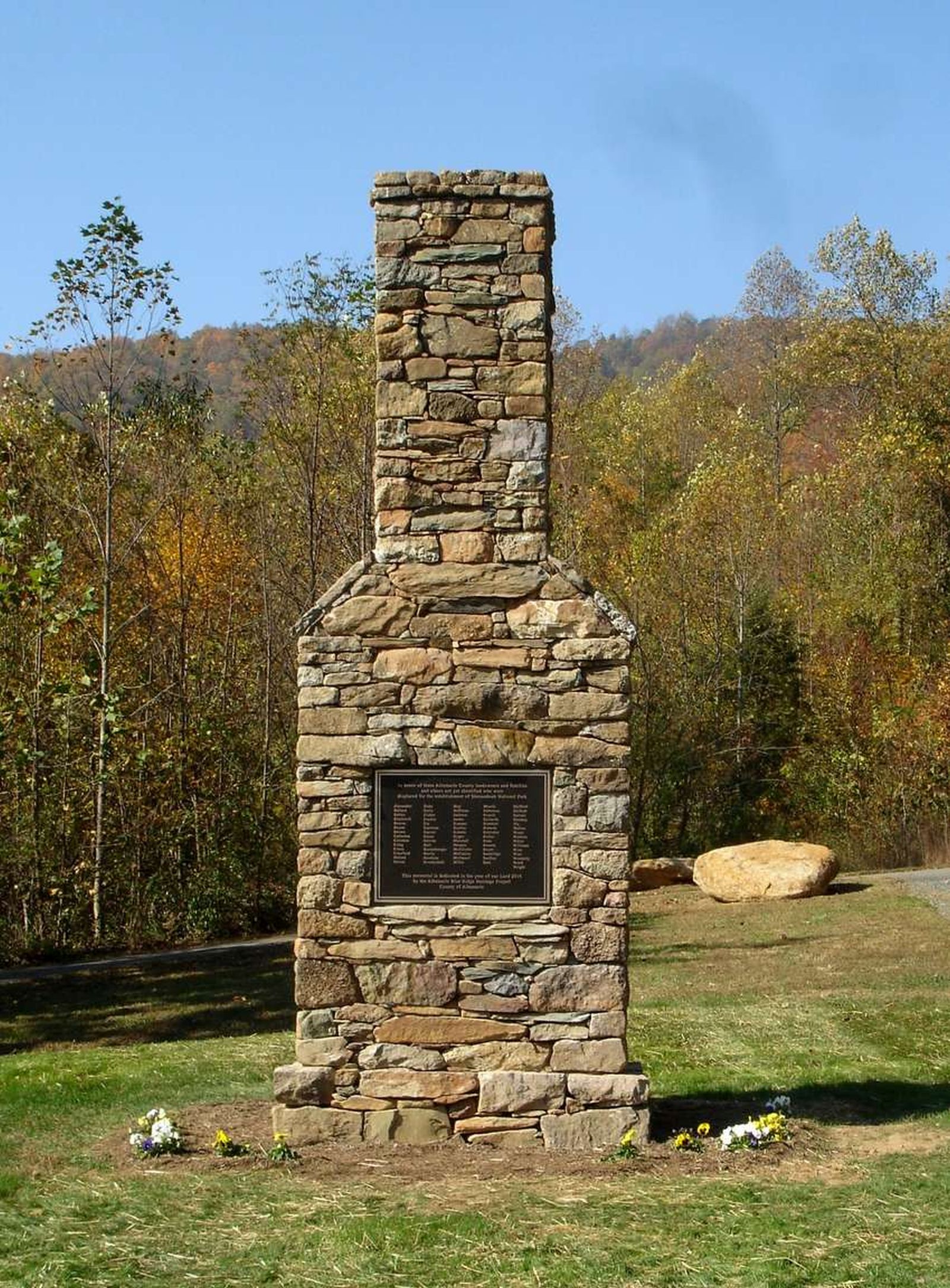
The Blue Ridge Heritage Project is a non-profit organization whose mission is to build monuments to honor the people who were displaced by the creation of Shenandoah National Park. Currently, six of the eight counties from which mountain residents were relocated have monuments: Madison, Page, Rockingham, Greene, Rappahannock, and Albemarle. Warren has a site selected and Augusta is in the planning stages. Most of the monument sites include exhibits about the families. We invi
A large replica sandstone chimney features a bronze plaque bearing the surnames of the families displaced from Albemarle County.
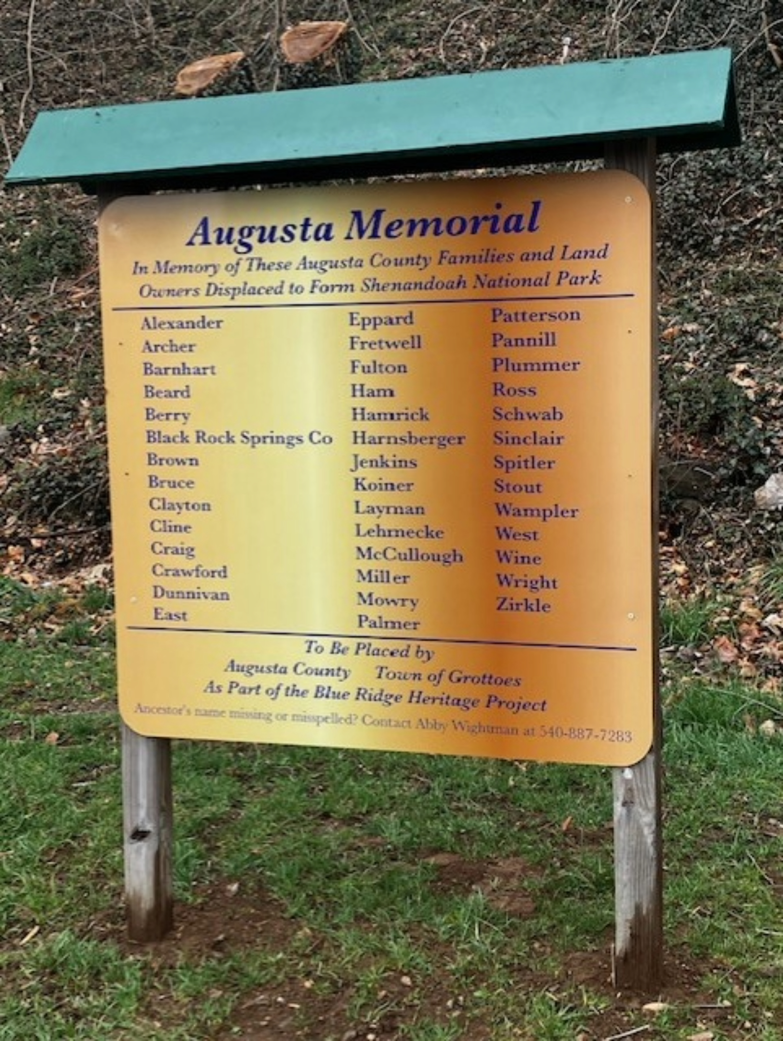
The Blue Ridge Heritage Project is a non-profit organization whose mission is to build monuments to honor the people who were displaced by the creation of Shenandoah National Park.
A gold-hued sign with a green roof lists the names of former residents of Shenandoah National Park. The sign stands against the slope of a hill scattered with trees, leaves, and shrubs. Around the area is the Grand Caverns Park.
The Blue Ridge Heritage Project is a non-profit organization whose mission is to build monuments to honor the people who were displaced by the creation of Shenandoah National Park. Currently, six of the eight counties from which mountain residents were relocated have monuments: Madison, Page, Rockingham, Greene, Rappahannock, and Albemarle. Warren has a site selected and Augusta is in the planning stages. Most of the monument sites include exhibits about the families. We invi
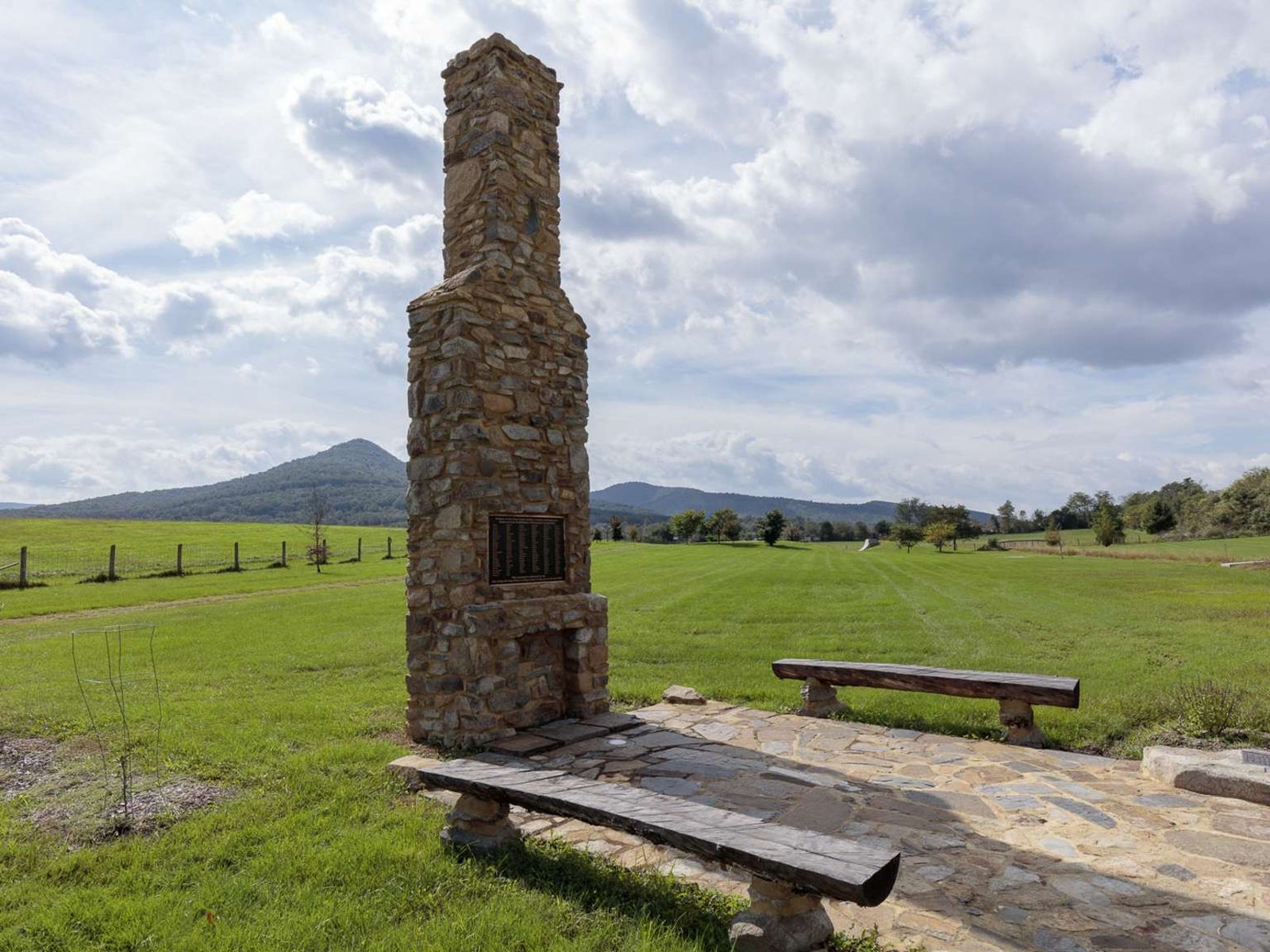
A large replica sandstone chimney features a bronze plaque bearing the sir names of the families displaced from Madison County. There are wooden benches set several feet back from the chimney allowing for contemplation.
The Blue Ridge Heritage Project is a non-profit organization whose mission is to build monuments to honor the people who were displaced by the creation of Shenandoah National Park. Currently, six of the eight counties from which mountain residents were relocated have monuments: Madison, Page, Rockingham, Greene, Rappahannock, and Albemarle. Warren has a site selected and Augusta is in the planning stages. Most of the monument sites include exhibits about the families. We invi
A large replica sandstone chimney features a bronze plaque bearing the sir names of the families displaced from Page County.
The Blue Ridge Heritage Project is a non-profit organization whose mission is to build monuments to honor the people who were displaced by the creation of Shenandoah National Park. Currently, six of the eight counties from which mountain residents were relocated have monuments: Madison, Page, Rockingham, Greene, Rappahannock, and Albemarle. Warren has a site selected and Augusta is in the planning stages. Most of the monument sites include exhibits about the families. We invi
A large replica sandstone chimney features a bronze plaque bearing the sir names of the families displaced from Rappahannock County.
The Blue Ridge Heritage Project is a non-profit organization whose mission is to build monuments to honor the people who were displaced by the creation of Shenandoah National Park. Currently, six of the eight counties from which mountain residents were relocated have monuments: Madison, Page, Rockingham, Greene, Rappahannock, and Albemarle. Warren has a site selected and Augusta is in the planning stages. Most of the monument sites include exhibits about the families. We invi
A large replica sandstone chimney features a bronze plaque bearing the sir names of the families displaced from Rockingham County.
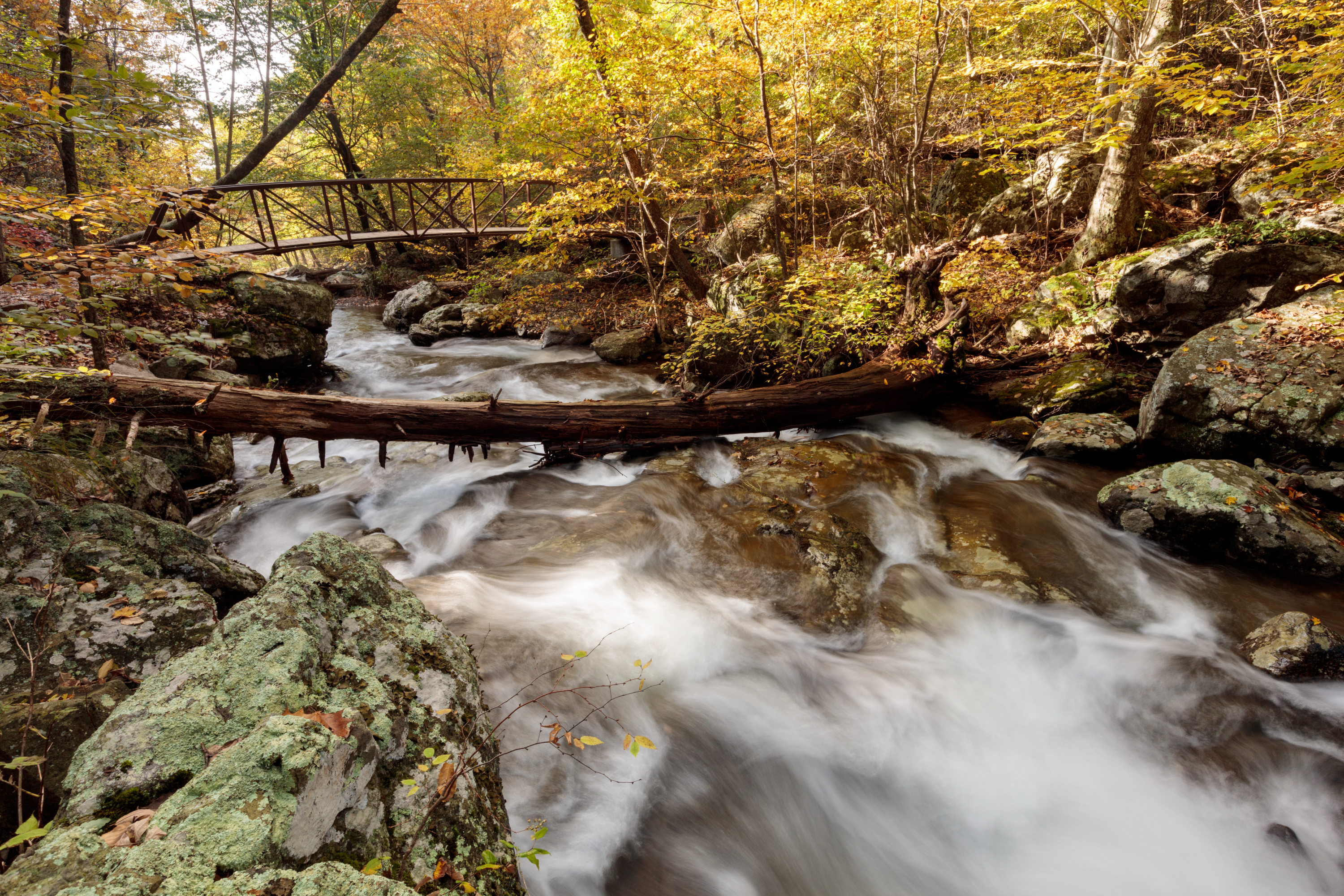
A wooden bridge, approximately 72 feet long by 8 feet wide, with wooden posts on either side about 4 feet high. The bridge spans a shallow creek about 30 feet wide. The densely forested land rises gently on both sides of the river. A stone bridge, approximately feet long by 12 feet wide, with stone walls on either side about 3 feet high. The bridge spans a shallow creek about 24 feet wide. The heavily forested land rises sharply on both sides of the river.
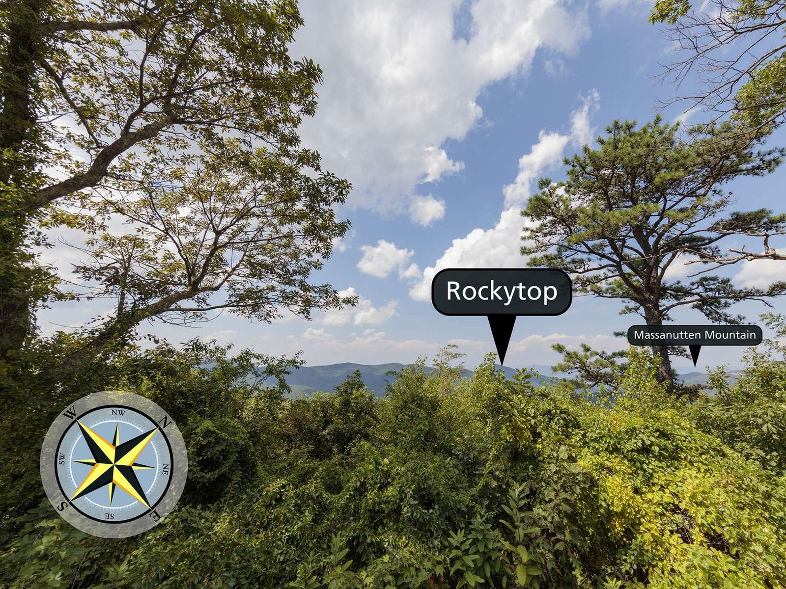
Brown Mountain Overlook sits at an elevation of 2,844 ft (866 m). This overlook is long, with views from north to south of Two Mile Ridge, Rocky Mount, Rockytop, Trayfoot Mountain, and the Shenandoah Valley.
The view from this long overlook faces south to north. The view slopes downward and opens up to the mountains in the distance. From the left, southern end, is the point of Trayfoot Mountain in the far distance, Big Run in the valley when the mountains descend, and Rockytop Mountain in the distance. Rocky Mountain is to the right of Rockytop and extends in front of a large portion of the view. When Rocky Mountain begins to descend the view is facing northwest. To the right of Rocky Mountain is Two Mile Ridge, and Rocky Mount (different from Rocky Mountain). At the horizon facing north, the Shenandoah Valley and Massanutten Mountain are visible on a clear day.
Browns Gap Parking Area (mile 83) | This circuit hike leads you through designated Wilderness to Upper and Lower Doyles River Falls, as well as Jones Run Falls.
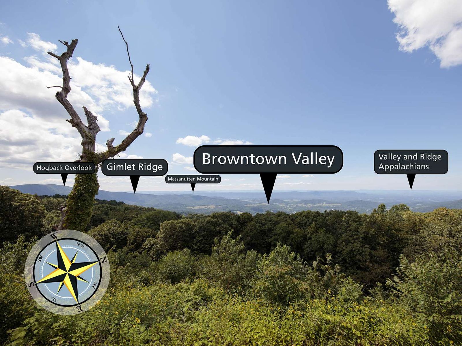
Looking west-northwest from an elevation of 2,890 ft (880 m), you will see the view of an historic community and surrounding hills from the Browntown Valley Overlook
The view from this overlook faces west-northwest over a line of bushes and trees into Browntown Valley. On the far side of the valley is Gimlet Ridge with Hogback Overlook visible at the top of the ridge. Beyond Browntown Valley there is the Shenandoah Valley with the Massanutten Mountain Range dividing the valley and the Valley and Ridge Appalachians visible in the far distance.
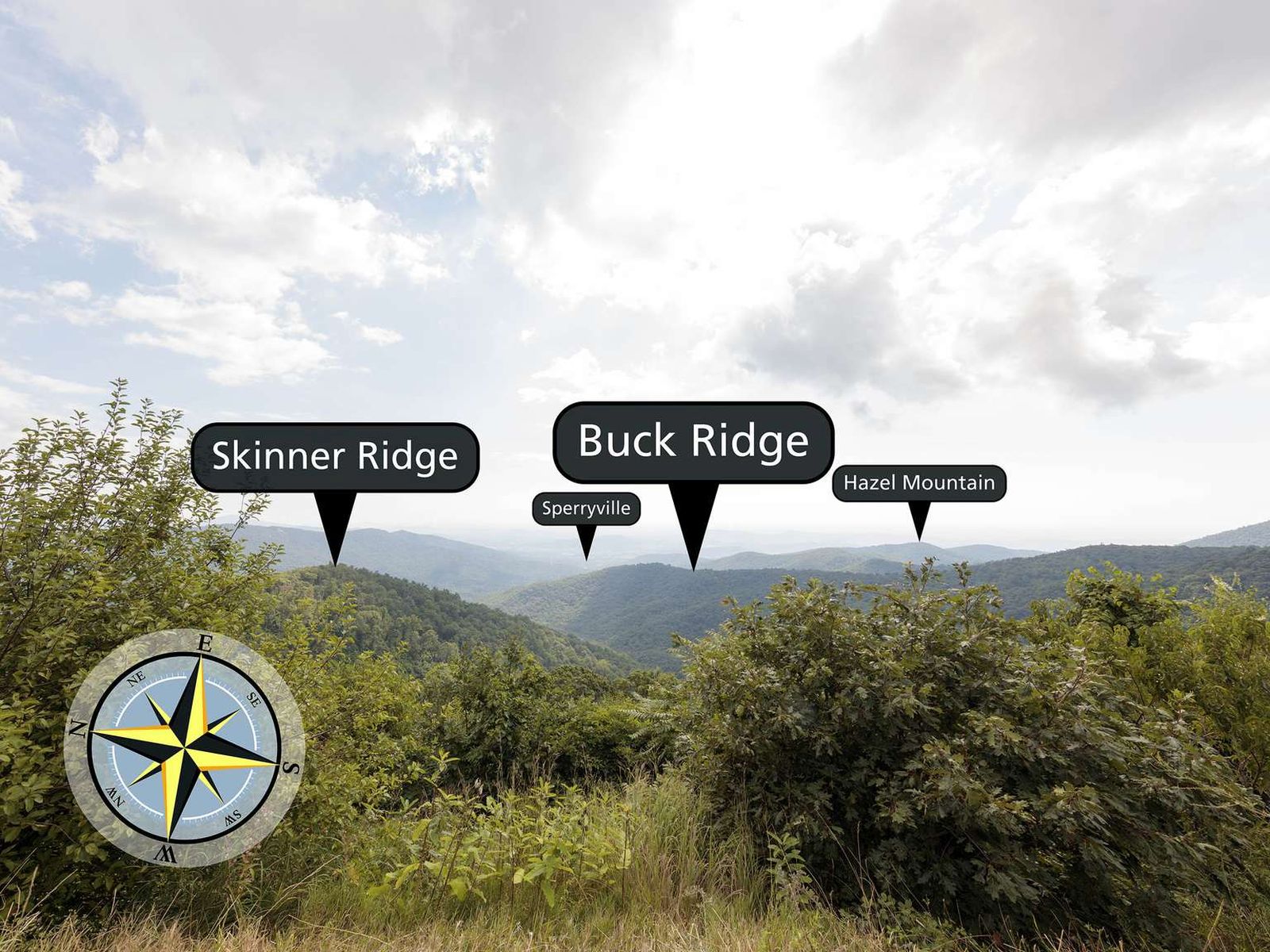
Stop at Buck Hollow Overlook, facing east-northeast from an elevation of 2,710 ft (826 m), and look out over the mountains! Skinner Ridge is visible towards the left, while Buck Ridge makes its way from the right toward the center of the view.
The view from this overlook faces east-northeast. There are many bushes and shrubs close to the overlook. A smaller hill towards the left is Skinner Ridge. From straight ahead and off to the right is a ridge called Buck Ridge. Off in the distance on the right is the dome of Hazel Mountain. Towards the horizon on the left is a town named Sperryville.
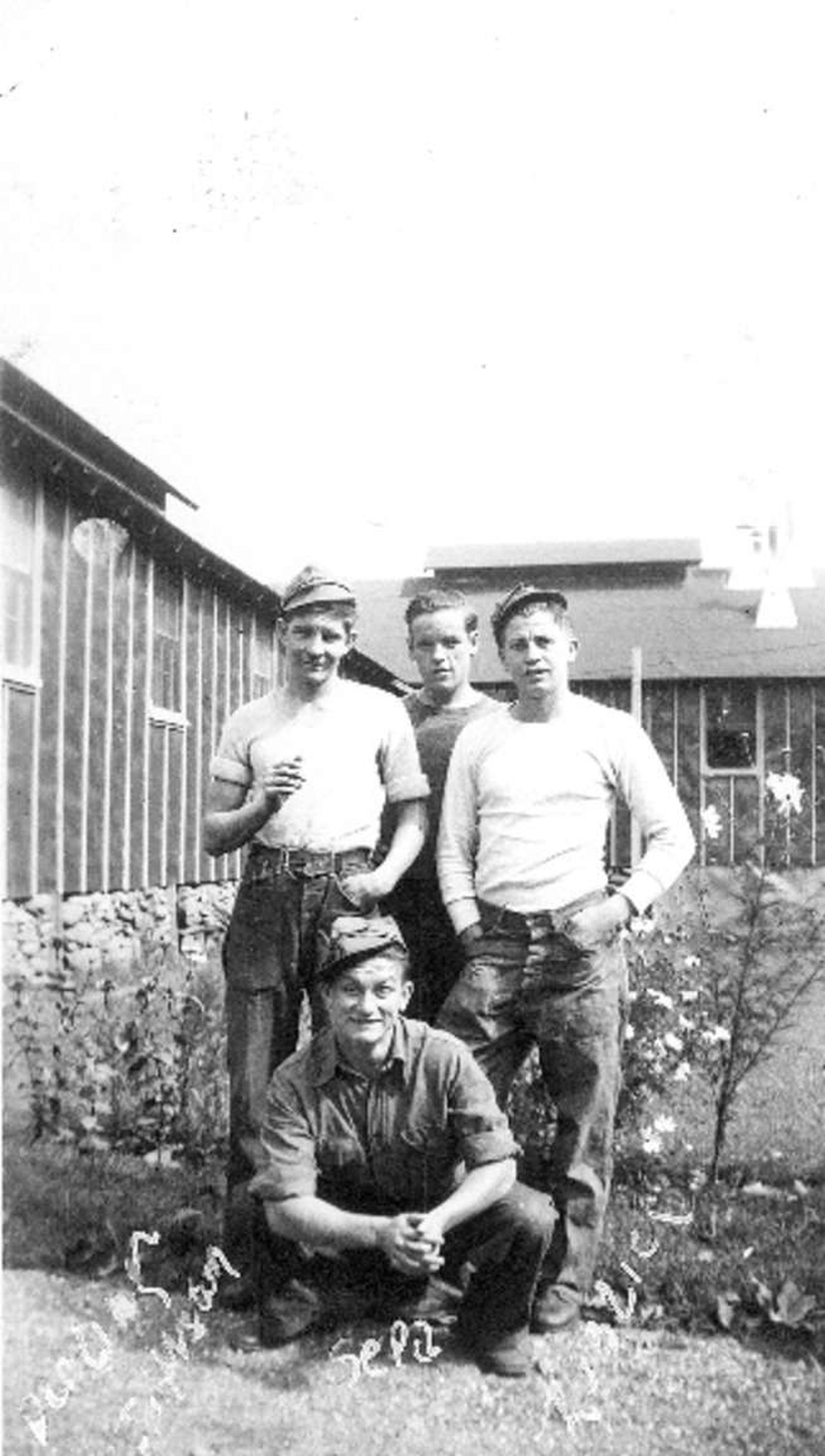
The enrollment period for the CCC was initially for six months, but an enrollee could re-enlist for up to a maximum of two years. Enrollees were required to take an oath, swearing to obey those in authority and follow all rules and regulations. Some of the boys adjusted more easily to a regimented life than others. Those who had come from rural backgrounds tended to have an easier time with the labor than those from more urban backgrounds. Others suffered from homesickness a
A small, rectangular sign in a silver frame mounted on a metal post. There is a black and white image of a CCC worker in the CCC plant nursery. The nursery is out in the open, fenced in by a chestnut rail fence. The worker is standing next to a wood frame box on the ground, a plant bed containing seedlings, with a wood lath cover. On this sign there is also a graphic of what the barrack looked like, a long rectangular building with many windows and a door on the front and side. In the upper left of the sign there is a graphic of the CCC insignia. Accompanying text: "BARRACKS" Although the boys' days began and ended in the barracks, they spent little time there otherwise. Reveille was at 6:00 a.m., followed by flag-raising and barracks clean-up. Then, breakfast, chores around camp, and off to assigned work projects. The boys build trails, laid phone line, and fought forest fires. Their work also included landscaping and reforestation. Camp NP-2's nursery supplied seedlings that helped create the beautiful foliage you see along Skyline Drive today.
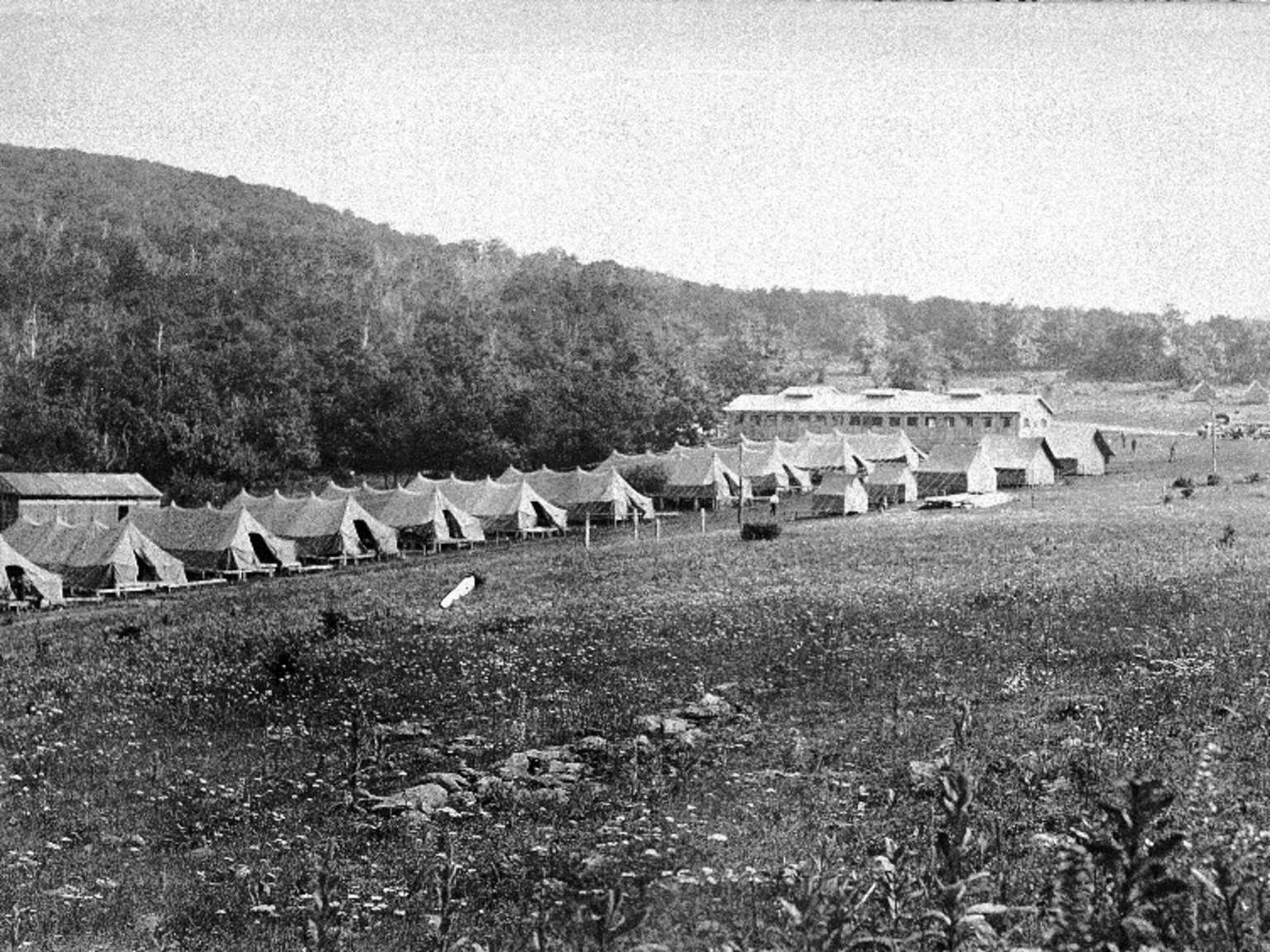
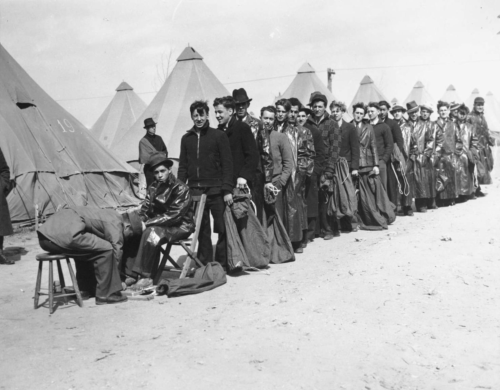
Given the speed with which the CCC was started, the first enrollees didn't arrive to finished camps in May of 1933 but rather, in the early months, they lived in surplus WWI tents. As the organization of the CCC evolved, more standardization was introduced into the building of the camps but almost all camps were built around a common open space or "Company Street."Shenandoah National Park had 10 different camps at various times throughout the nine years of the Civilian Conser
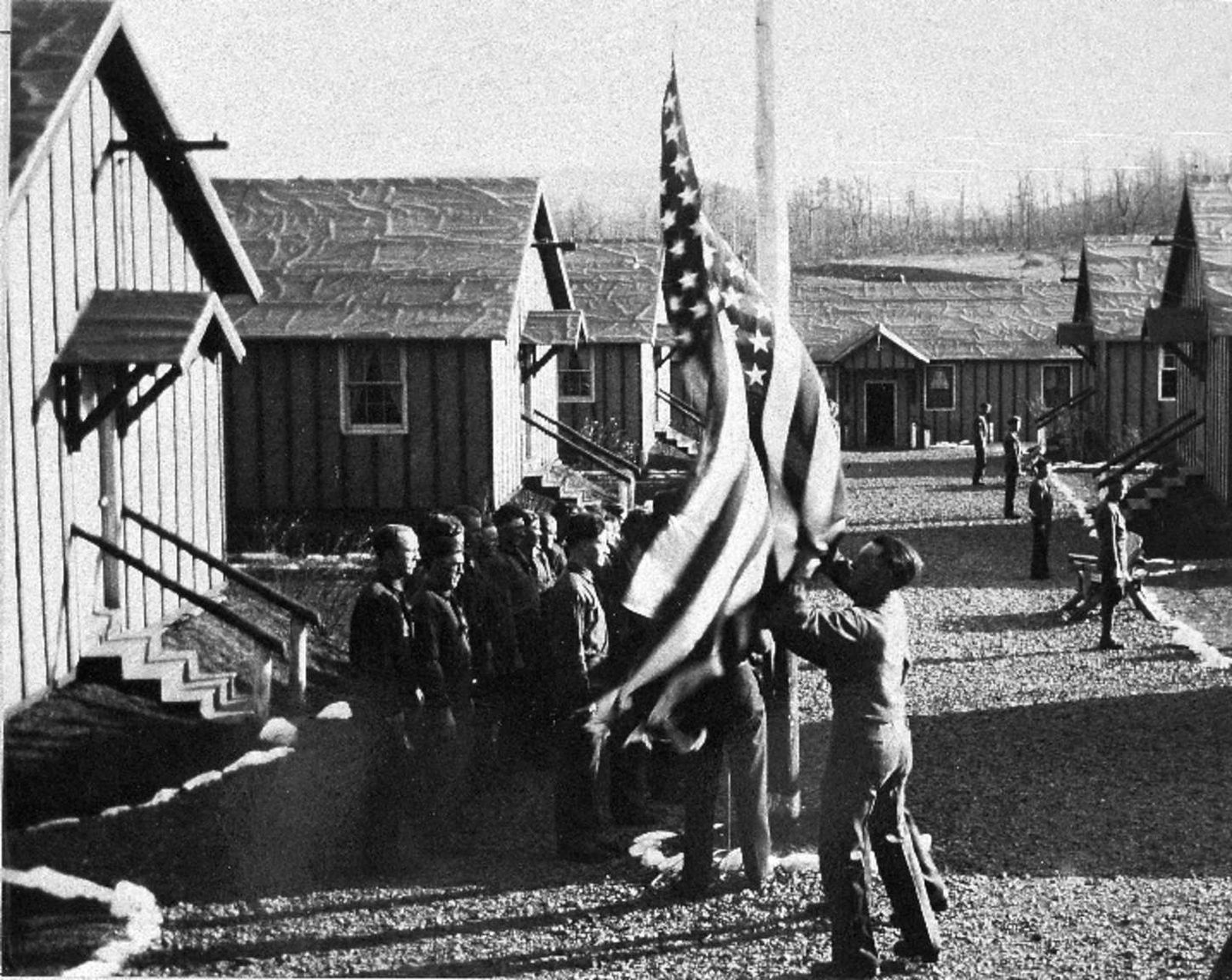
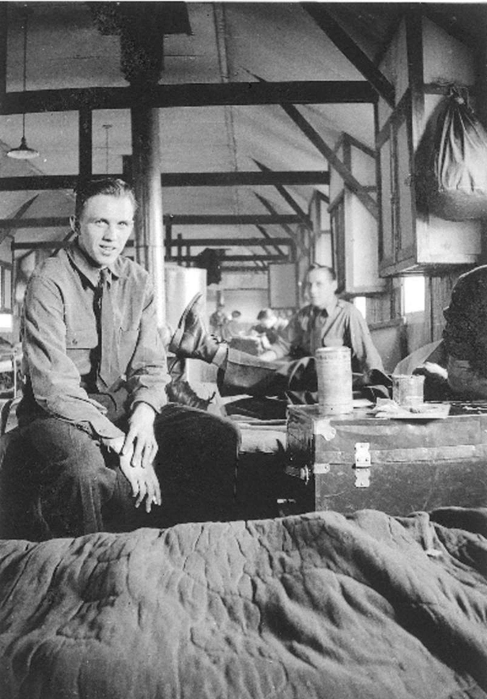
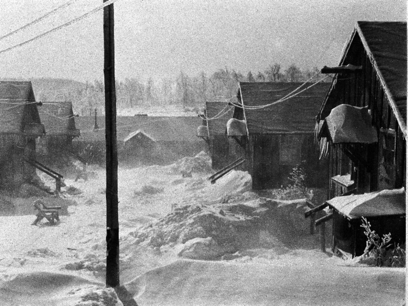
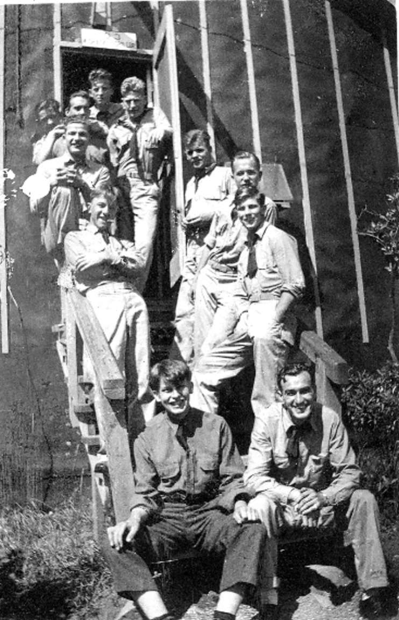
A small, rectangular sign in a silver frame mounted on a metal post. There is a black and white image, taken outside, looking down the "Company Street" and the entrances to all five barracks. The bathhouse is at the end of the "street." There is snow on the ground. There are benches outside each barrack. On this sign there is also a graphic of what the barrack looked like, a long rectangular building with many windows and a door on the front and side. In the upper left of the sign there is a graphic of the CCC insignia. Accompanying text: "BARRACKS" "Home Away From Home!" Barracks were no frills, utilitarian structures. Each building housed between 30 and 40 enrollees. Camps were flexible; buildings were routinely erected, then dismantled and moved. In later years all the camps were designed alike and buildings were prefabricated. However, this camp was one of the first and had a unique, but changing layout. In 1934 NP-2 had five barracks buildings, three on the north side facing two more on the south.
In the beginning, the official requirements for being a CCC enrollee were to be a man between the ages of 18-25, unmarried, and in need of assistance. (Although some older WWI veterans were also allowed to enroll.) Unofficially, some of the CCC boys lied about their ages to enter the Corps. CCC enrollees earned 30 dollars a month, a dollar a day, but $25 were automatically deducted and sent back home to their families, thus spreading the economic benefits of the program to th
A small rectangular sign in a silver frame mounted on a metal post. There is a black and white image taken from inside the barracks, looking down the length of the building. There are wooden cross beams on the ceiling and a door at the far end. In the foreground is a wooden stove used to heat the building. There are multiple cots positioned on each side of a middle aisle which runs the length of the building. Each cot has a blanket rolled at the foot of the cot. There are clothes and duffel bags hanging by the head of each cot. Each cot area looks similar to the next. On this sign there is also a graphic of what the barracks looked like, a long rectangular building with many windows and a door on the front and side. In the upper left of the sign there is a graphic of the CCC insignia. Accompanying text: "BARRACKS" Barracks living was sparse. Each enrollee had a cot and a small storage area. Barracks were kept immaculate, scrubbed regularly by the boys on Saturdays after their half-day in the field. NP-2 barracks had electricity, but they were heated with wood. Maintaining the heat was another way an industrious enrollee could make a few extra dollars. Enrollees would each chip in 25 or 50 cents a month to pay one boy to "keep the home fires burning" during the long, cold nights.
Winters would have been cold here on the mountain but there was no shortage of firewood to heat the stoves. When the CCC boys arrived at Shenandoah, they found a landscape that had been ravaged by the chestnut blight, a fungus that had been unintentionally imported from Asia and which had destroyed the American Chestnut. In the space of 30 years, the majestic trees which made up 25% of the forest ecosystem had died and left a "ghost forest" behind. It was a huge economic and
A small, rectangular sign in a silver frame mounted on a metal post. There is a black and white image taken from inside the bathhouse looking down a double-sided row of metal sinks, with eleven sinks on each side. There is one young man washing his hands at a sink. Behind him is a white partitioning wall with several mirrors hanging on it. On this sign there is also a graphic of what the barracks looked like, a long rectangular building with many windows and a door on the front and side. In the upper left of the sign there is a graphic of the CCC insignia. Accompanying text: "BARRACKS" This was the last barracks in the northern row. Boys in this building were lucky to be nearest the bathhouse which was located at the end of the "company street." NP-2's bathhouse had 22 stainless steel sinks that were scrubbed daily. Enrollees took turns on guard duty at night and were responsible for feeding the kitchen stoves and the bathhouse hot water boiler. Still, even with the promise of a hot shower, the dash to the bathhouse must have been a dreaded winter event.
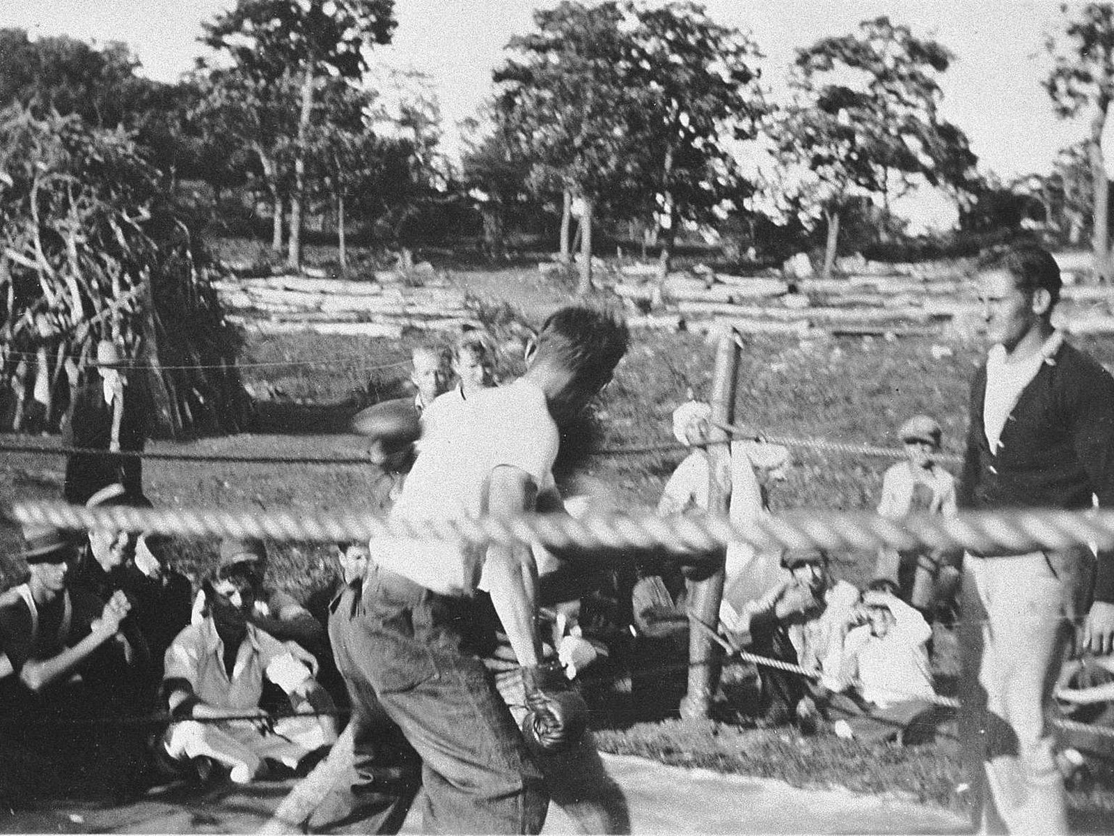
Living in close quarters, with little privacy, conflicts inevitably arose. As well as being fun, participating in competitive sports, including boxing, was one way of dealing with tensions as they arose.The boys came from varied backgrounds, rural and urban, and for many it was their first journey away from home. Being in the CCC exposed these young men to people completely different from themselves and gave them an opportunity to learn how to get along. Many an enrollee left
A small, rectangular sign in a silver frame mounted on a metal post. There is a black and white image of a CCC baseball game. It is a wide view encompassing the whole baseball field and including players in the outfield. A line of trees is visible in the background. In the foreground many men are on the sidelines or sitting on benches watching the game. On this sign there is also a graphic of what the barrack looked like, a long rectangular building with many windows and a door on the front and side. In the upper left of the sign there is a graphic of the CCC insignia. Accompanying text: "BARRACKS" After a day of picks and shovels, dynamite and rocks, you would think the boys would head straight for their bunks. But instead they headed to class to play, or to town! Camp NP-2 boasted "the best baseball field on the mountain." The field was located to your right towards Skyline Drive. The boys played pick-up games as well as organized competitions against other camps and some local teams from the valley. Victories secured bragging rights for the Camp Commander.
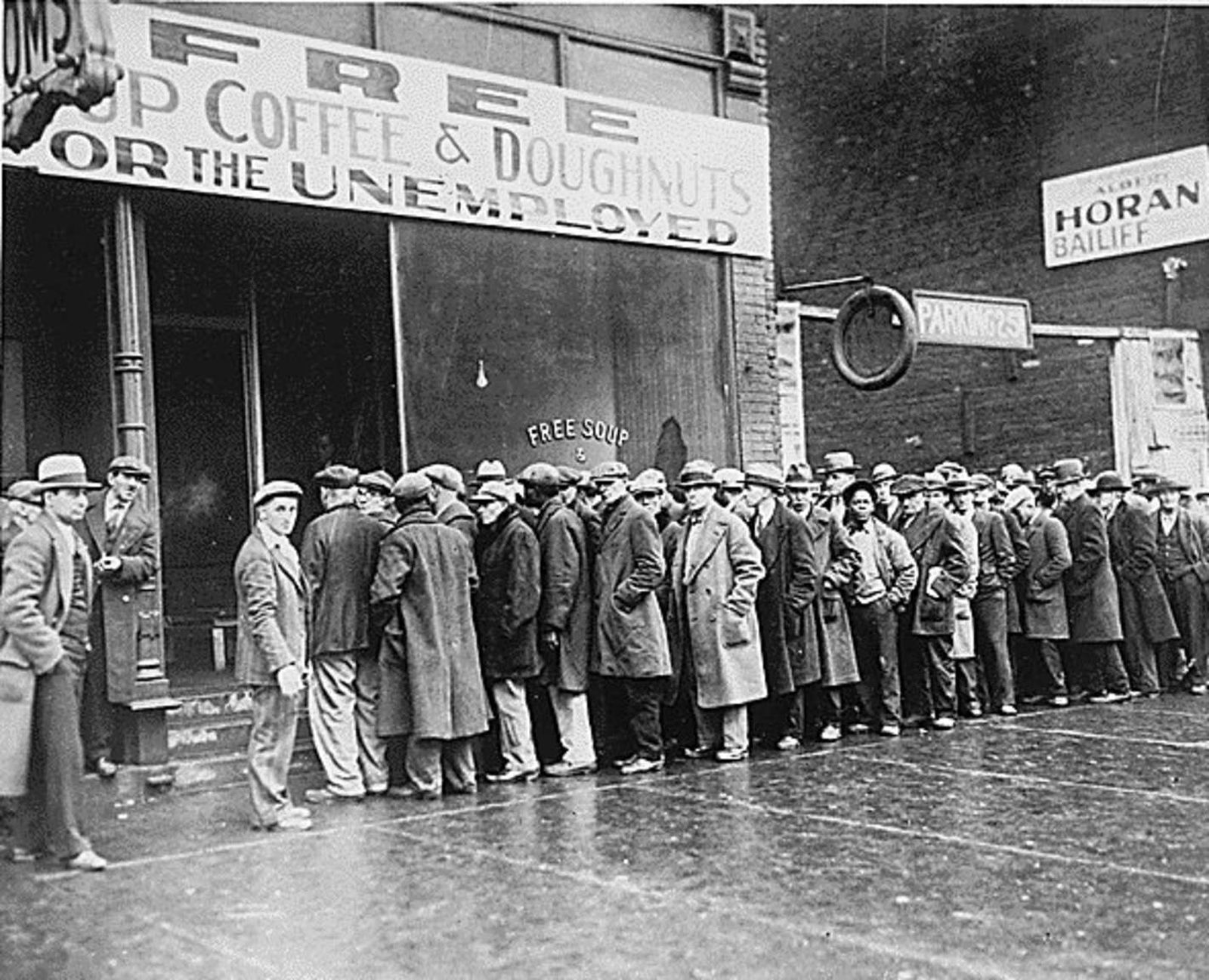
The year was 1933. The nation had been struggling for years with the effects of the Great Depression. Unemployment reached as high as 12 million people, equivalent to 25% of the eligible working population. People had lost their savings and livelihoods, bread lines were long and morale was low. Adding to the economic woes, the United States was also facing severe ecological issues. Drought conditions, poor farming practices and indiscriminate timber harvesting were contributi
A large rectangular panel in a brown frame mounted on brown posts. On this panel there is a small graphic of the National Park Service arrowhead in the upper left corner. On the panel there are multiple black and white images and graphics related to this site, a former Civilian Conservation Corps (CCC) camp. The graphics depict ten buildings found within the camp and where they were located i.e., how the camp was laid out. There is also a large red star with the accompanying text "You Are Here. "The first image depicts three young men, CCC enrollees wearing work clothes and hats, using shovels to dig a ditch. The second image depicts the company sign, which is mounted on a wooden post. The text of the sign reads: "United States Dept. of Interior, Shenandoah National Park, Camp N.P.2, 350 Company C.C.C., Camp Fechner, Big Meadows, National Park Service." The third image depicts four young men wearing work clothes, CCC enrollees, posing and smiling for the camera. Accompanying Text for the images: "Imagine this meadow as the hub of activity that was daily life. From "Reveille" to "Taps," thousands of boys worked, played, and learned here for nearly a decade. At the end of each workday, the boys NP-2 returned here to their home away from home." Accompanying Text: "A HOME AWAY FROM HOME" Paragraph 1: The Civilian Conservation Corps (CCC): If you study the landscape carefully, you will see the remnants of a road here- the road to a new life for hundreds of young men. This was the entrance to Camp NP-2, one of the first outposts of President Franklin Roosevelt's Depression-era work relief program, the Civilian Conservation Corps. The first enrollees arrived in 1933, each with a renewed sense of hope for a better life for himself and his family, and for a nation in distress. Paragraph 2: Exploring Camp NP-2 Today: After the CCC program ended, the camp was dismantled leaving few traces. Archeologists have identified the locations of the camp's building now marked with posts and selective mowing. Each building site is identified by a sign that reveals a small part of the story of the "boys" of Shenandoah. Continue your exploration of the CCC story at Byrd Visitor Center.
The legacy of the CCC is vast and varied. The program affected change on both the personal and national levels. For the young men who came in with minimal or poor education, they learned how to properly read and write. Others learned the technical and construction skills that would serve them well in their later careers. Many saw parts of the country they had never seen before.
A small rectangular sign in a silver frame mounted on a metal post. There is a black and white image of nine young men in uniforms, three sitting at a table and the rest sitting at school desks. They are all reading or writing, some of them with heads bent together and working in pairs. On this sign there is also a graphic of what the education building looked like, a long rectangular building with many windows and doors. In the upper left of the sign there is also a graphic of the CCC insignia. Accompanying text: "EDUCATION" Like many other ideas, the CCC Education program evolved and adapted to the needs of the Corps and the enrollees. Early emphasis was on traditional academic courses and some enrollees achieved their GEDs or took technical courses like auto mechanics and electricity. The education program evolved to include popular topics like photography, and journalism classes which produced the camp newspaper. Later, as war seemed inevitable, the emphasis changed again to include skills that would be valuable to the WWII effort such as radio communication.
When setting up a camp, the mess hall was the typically the first building built. The idea behind the CCC was to put men to work, not machines, so they needed proper nutrition to fuel their various labors. <br />The food was basic, but plentiful, and having regular meals three times a day was a welcome change for most of the CCC boys who had been living off more meager rations during the Depression.
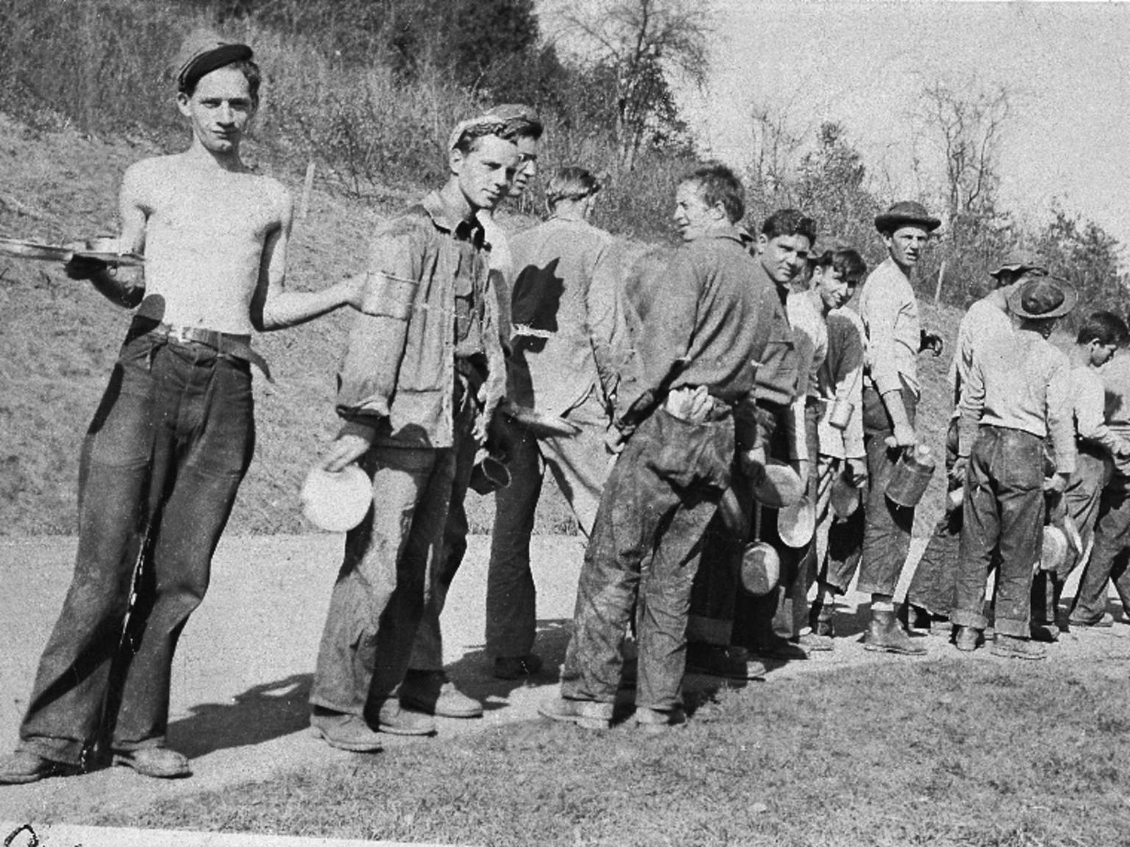
A small rectangular sign in a silver frame mounted on a metal post. There is a black and white image of many young men dressed in uniforms eating at the tables in the mess hall. In the background are several windows with white curtains on them. On this sign there is also a graphic of what the mess hall looked like, a long L-shaped building with many windows and multiple doors. In the upper left of the sign there is also a graphic of the CCC insignia. Accompanying text: "MESS HALL" It didn't take the military long to realize that feeding these hardworking, hungry young men three meals a day was quite a challenge. Menus were centrally planned with non-perishables shipped from military storehouses. Perishables came from local sources, pumping much-needed money into nearby businesses. Each camp had a mess sergeant responsible for providing huge breakfasts, bagged lunches for the field, and nourishing dinners. The average CCC boy gained 12 boys in the first two months.
There were many agencies involved in getting the CCC men here: the Department of Labor recruited and enrolled the men, the Department of Interior (under which the National Park Service is administered) and Department of Agriculture provided the work projects and the War Department/Army ran the camps. Despite the many agencies involved, the CCC was up and running with incredible speed. From Roosevelt's initial meeting with his Cabinet regarding the CCC on March 9, 1933 to the
A small rectangular sign in a silver frame mounted on a metal post. There is a black and white image of two men in uniforms standing in front of the office building, a structure with a simple wooden external frame. The photo is from the early 1930's and the uniforms are from that era or earlier. The men are wearing jodhpurs and campaign hats. On this sign there is also a graphic of what the office looked like, a simple one-story square building. In the upper left of the sign there is also a graphic of the CCC insignia. Accompanying Text: "OFFICE" The building at this location was an office. According to the original plan, the Army would run the camps and the National Park Service would formulate, design, and oversee the work projects. Each camps was supervised by a career or reserve Army "Camp Commander" assisted by a supply sergeant, a mess sergeant, and a military cook. Doctors, dentists, and chaplains were also assigned to rotate between camps. NPS landscape architects and engineers supervised the "boys" in the field.
After a long, hard day of work, this building must have the place to come for a little relaxation. But the boys wouldn't just stay up on the mountain, even if their dances did sometimes attract hundreds of attendees. Needing a change of scene, they might go on Friday and Saturday nights down into the nearby towns to attend movies and the local dances.
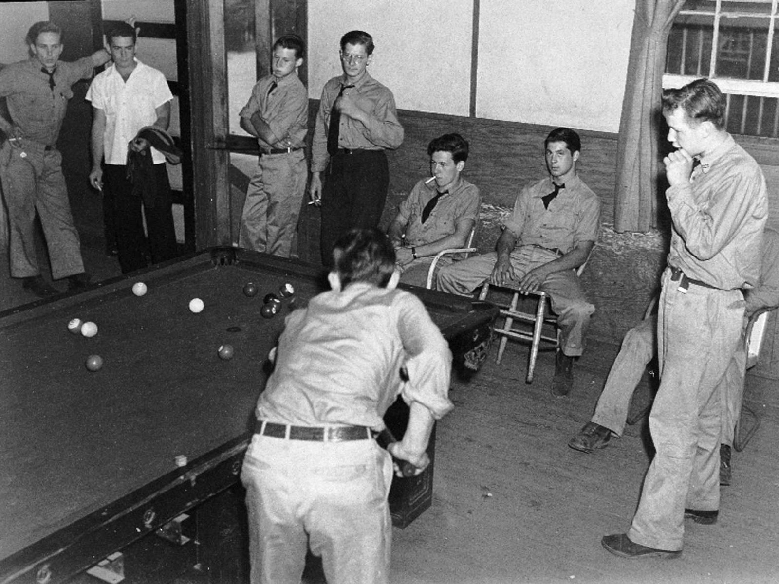
A small rectangular sign in a silver frame mounted on a metal post. There is a black and white image of a young man standing in front of multiple shelves containing merchandise such as cigarettes, soap, candy and reading materials. He is wearing a shirt and tie and there is a rectangular window with glass panes behind him. On this sign there is also a graphic of what the recreation building looked like, a long, straight one-story building with a covered porch running along one side. In the upper left of the sign there is also a graphic of the CCC insignia. Accompanying Text: "RECREATION" Each camp had a Recreation Hall. The Camp Store was located there and sold cigarettes, toiletries, and trinkets to send home to moms and sweethearts. The profit from the Camp Store funded the Rec Hall amenities such as pool or ping pong tables and sports equipment. In addition to baseball, basketball, football, billiards, and boxing were competitive sports among Shenandoah's camps. On occasion, the boys would dress up the Rec Hall and a bus would bring in the local girls for a dance.
The building of Skyline Drive was a labor-intensive endeavor. Though the CCC did not engineer and build the road itself (that was done by the Bureau of Public Roads) they designed and created the overlooks as well as worked to control the erosion on the hillsides created from it's construction. Additionally, they planted hundreds of thousands of trees and plants, including mountain laurel, creating the beautiful "natural" landscaping we enjoy today as we take a drive along th
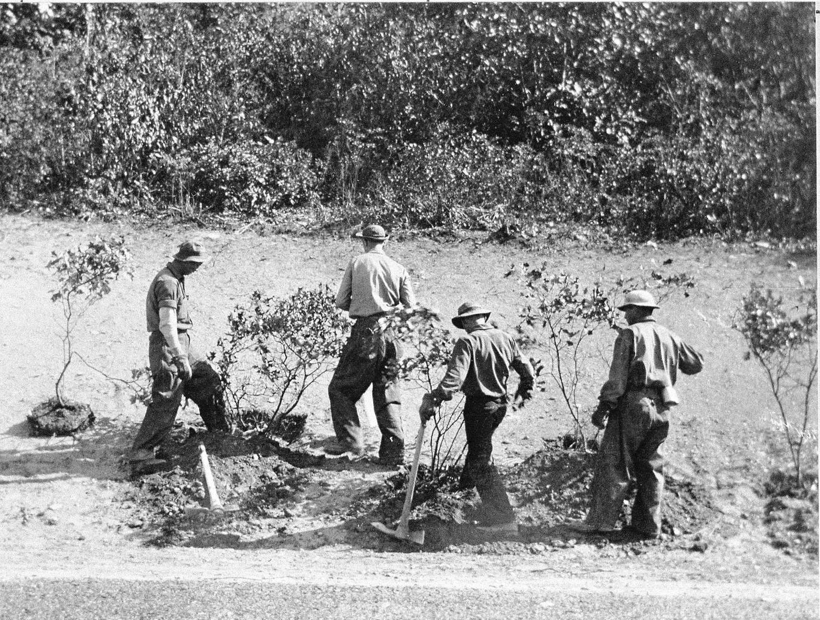
A small rectangular sign in a silver frame mounted on a metal post. There is a black and white image of a young man in a workshop. He is hammering a nail into wooden topographic model. Behind him are desks and long shelves upon which are lying many rolled up documents, potentially blueprints. On this sign there is also a graphic of what the technical building looked like, a long L-shaped, one-story structure. In the upper left of the sign there is a graphic of the CCC insignia. Accompanying Text: "TECHNICAL" The CCC boys arrived in Shenandoah at the perfect time. Their first work was along the Skyline Drive right-of-way because the park had not yet been officially established. Once the park was established in 1935 their work expanded to the extensive task of making the park ready for visitors. They build infrastructure and worked on reforestation , as well as amenities such as trails, accommodations, and even picnic tables and water fountains. Their work was planned by architects, landscape architects, forestry biologists, and engineers who worked in the technical building.
The CCC worked on every aspect of vegetation and reforestation management in the Park. They grew and planted new seedlings, cleared the understory of dead brush and trees, and moved shrubs and trees around from one area to another, particularly by picnic grounds, overlooks and other facilities. What might seem natural to us now is actually the product of extensive landscape manipulation.
A small rectangular sign in a silver frame mounted on a metal post. At the top of the sign there is also a graphic of the CCC insignia. Accompanying text: "FLOWER GARDEN" The CCC boys decorated their home away from home with ornamental flowers. Each spring narcissus, daffodils, and lilacs still bloom, marking the entrance to the Mess Hall and the head of Company Street. Archaeologists mapped the clumps and found the rows of flowers planted many years ago.
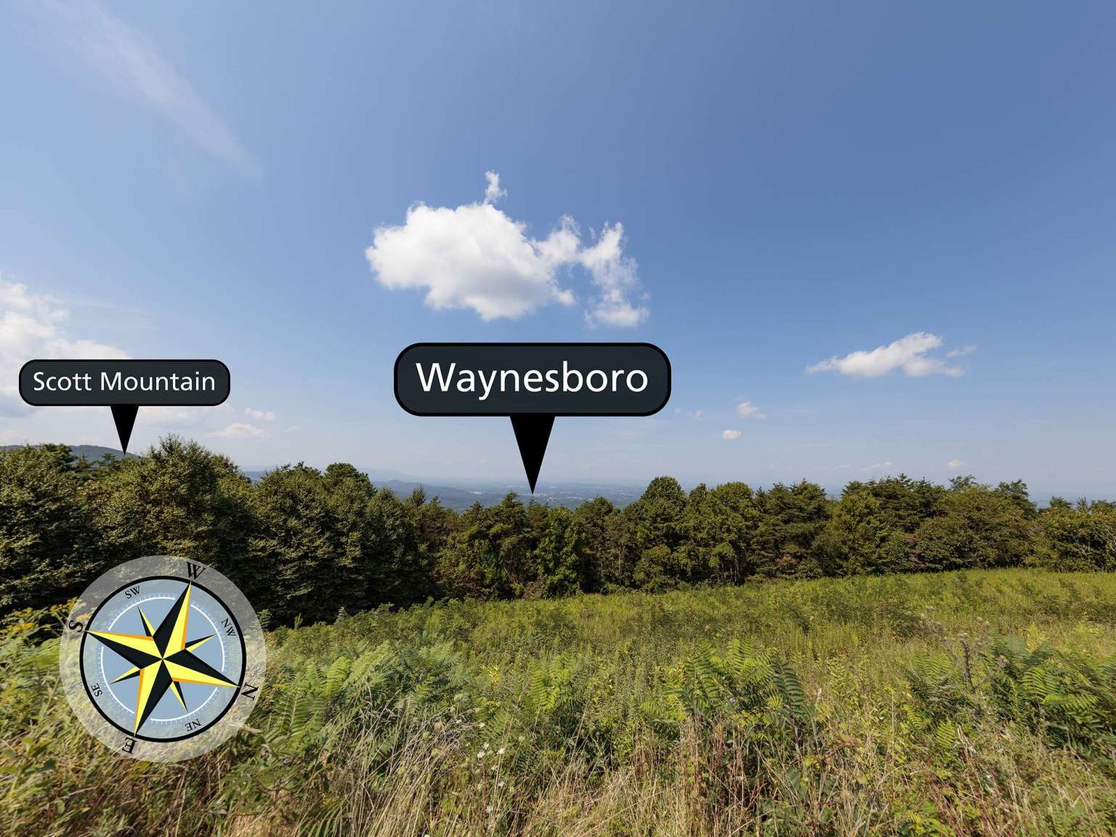
Facing west from an elevation of 2,480 ft (755 m), the view from Calf Mountain Overlook is straight out over the town of Waynesboro.
The view from this overlook faces west. There is a small field in the foreground that leads to a line of trees a little further back. Beyond the trees and at a lower elevation, there is a town. This is the town of Waynesboro in the Shenandoah Valley. To the left there is a mountain, Scott Mountain, that descends into the valley below.
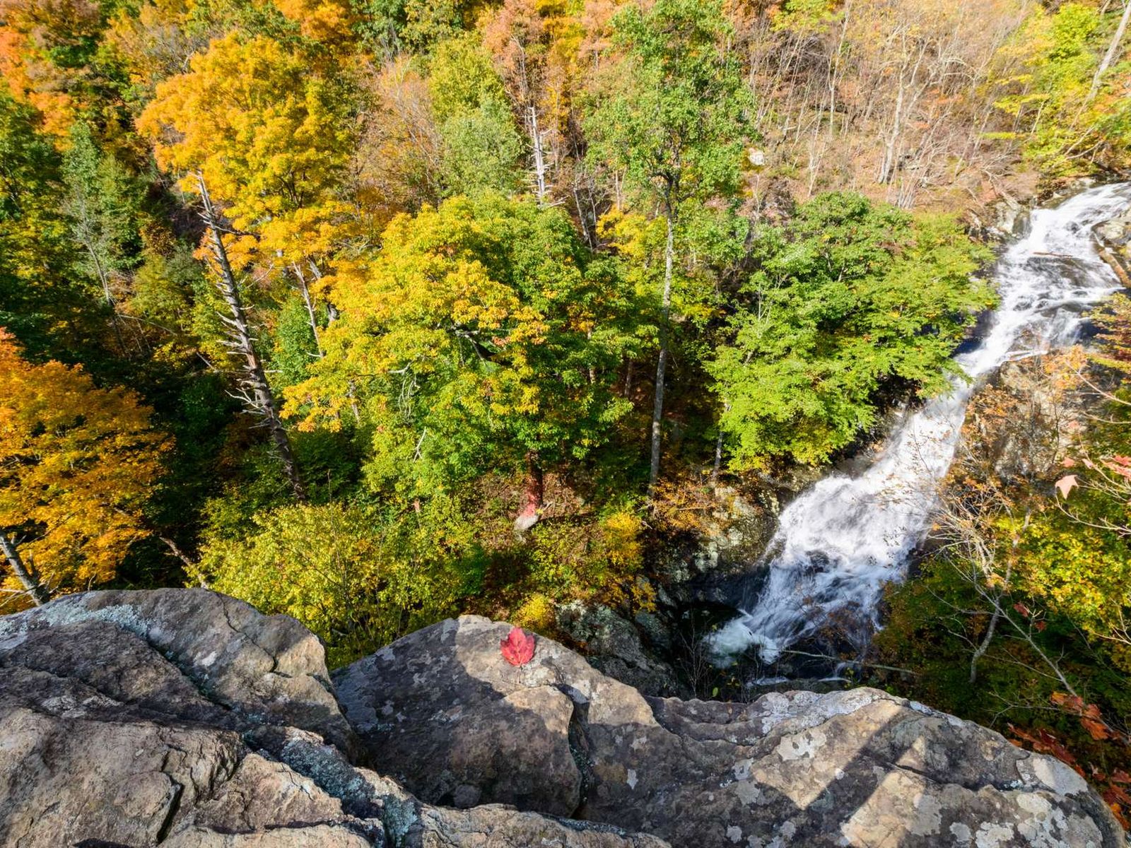
Hawksbill Gap Parking Area (mile 45.6) | This hike is very challenging, although those who do it are rewarded with exceptional cascades and waterfalls.
The Cedar Run Trailhead panel is a 36 by 54 inch color poster. On the left side of the panel is a photograph of two hikers descending rough, rock steps along a trail lined with bright green undergrowth, a huge boulder, and a standing dead tree trunk. The text reads, "An Ounce of Prevention: The dramatic waterfalls and scenic cascades of Cedar Run and Whiteoak Falls make this canyon popular with hikers. But these canyon trails are some of the toughest in the Park. They're very steep, and there are big rocks and roots to climb over. Consider these safety tips: Wear sturdy shoes Take plenty of water for yourself and your companions, including your pet! Review the map and make sure you have enough time to complete your hike before dark. Be honest with yourself and your group about your physical capabilities. After all, you want to return with only good memories." "Leave No Trace: More than a million people visit Shenandoah each year, many of them hikers. That's a good thing, but it's still a lot of feet tramping through the Park!" "Leave No Trace is a set of outdoor ethics that guides lovers of the outdoors toward treading lightly and lessening their impact on the earth. If all visitors practiced Leave No Trace principles, it would help Shenandoah stay clean, beautiful, and wild. In addition to heeding the safety tips above, remember: leave what you find; pack out what you pack in; stay on the trails; maintain a safe distance from , and do not feed , wildlife; and be considerate of others." The top right of the panel is a 20 by 20 inch topographic map of the hike to Cedar Run Trail and Whiteoak Canyon Trail. The trail is marked in yellow. The text reads, "Suggested Hike: Hike: Cedar Run Falls and Whiteoak Falls - 7.3-mile circuit, very strenuous, 6.25 hours hiking time, 2,794-foot elevation gain, several stream crossings. Descend on Cedar Run Trail. Cedar Run Falls follows the trail on the left. Cross the creek, and turn left on Whiteoak Canyon Trail. You'll see the Lower Whiteoak Falls and Upper Whiteoak Falls on your left as you ascend on the trail. After leaving the last of the waterfalls - Upper Whiteoak Falls - cross the creek and follow Whiteoak Canyon Road. Turn left onto the Skyland-Big Meadows Horse Trail, which will take you back to the starting point at Hawksbill Gap." A red text box below the map gives important information that hikers need. The text reads, "Emergency 1-800-732-0911 (cell phone service is unreliable.) Before You Go! Pets must be on a leash at all times. Do not attempt to cross streams during icy conditions or flooding. Be sure you are physically able to complete the hike you've chosen. Take plenty of water - at least a quart per hour Be sure you know your route. Free maps are available at entrance stations, visitors centers, and www.nps.gov/shen When you return from your hike, check for ticks. Be sure someone knows where you are and when to expect your return. It's dangerous and potentially deadly to climb on the rocks near waterfalls. Filter or treat water from streams before drinking."
Riprap Parking Area (mile 90) | An out-and-back hike to Chimney Rock, an excellent viewpoint with some very interesting geological features.
The Riprap Trailhead panel is a 36 by 54 inch color poster. On the upper left of the panel is a photograph of three hikers with backpacks trekking through the snow-covered forest on a winter's day. The text reads, "A Trail for All Reasons - People hike for different reasons, like exercise, adventure, or refreshment. Whatever your reason for hiking, you will find it on Riprap Trail. Explore the top of Chimney and Calvary Rocks and admire the captivating views of the hollow below. Follow the creek as it cascades down the mountain through thickets of berry bushes and rhododendron. Riprap Trail enchants hikers because it offers a memory at every turn. It's a microcosm of the 500 miles of trails that crisscross Shenandoah National Park." The picture on the bottom left of the panel is of a cement trail post with the Appalachian Trail (A.T.) symbol on it. Near the top of the post is a metal band that gives the trail name, direction, and mileage. The text reads, "Journey of Discovery - Thousands of people hike the legendary Appalachian Trail every year. Some walk for an hour, some for a few days. Some complete the 2,100-plus-mile journey on this famous trail that runs from Georgia to Maine. They are called thru-hikers, and traditionally they adopt trail names for the entire journey. These new identities describe aspirations, personalities, or memorable moments. "Sunshine," Mr. Starbuck," "Two Step," and "Chicken Wiffle" are just some of the thousands of thru-hikers who have walked the A.T. Look for northbound thru-hikers in the Park between May and June, and southbound thru-hikers in August and September." The top right of the panel is a 20 by 20 inch topographic map of the hike on Riprap Loop. The trail is marked in yellow with a brown dashed line. The text reads, "Suggested Hikes: Hike #1: Riprap Loop - 9.8-mile circuit, very strenuous, 8.25 hours hiking time, 2,365-foot elevation gain, several stream crossings. Follow the Appalachian Trail (A.T.) north. Turn left on Riprap Trail. Continue past Calvary Rocks and Chimney Rocks. Turn left on Wildcat Ridge Trail. Turn left on the A.T. north to return to your starting point." "Hike #2: Chimney Rock - (This trail is marked in purple with a dashed line.) 3.4-mile roundtrip, moderate, 2.5 hours hiking time, 830-foot elevation gain. Follow the Appalachian Trail north. Turn left on the Riprap Trail. After a series of switchbacks, a viewpoint will appear on your right. Further on, Calvary Rocks will appear on the left. Chimney Rock will then appear on your right. Retrace your steps to return to your starting point." A red text box below the map gives important information that hikers need. The text reads, "Emergency 1-800-732-0911 (cell phone service is unreliable.) Before You Go! Pets must be on a leash at all times. Do not attempt to cross streams during icy conditions or flooding. Be sure you are physically able to complete the hike you've chosen. Take plenty of water - at least a quart per hour. Be sure you know your route. Free maps are available at entrance stations, visitors centers, and www.nps.gov/shen. When you return from your hike, check for ticks. Stay on the trail and avoid trampling sensitive vegetation. Be sure someone knows where you are and when to expect your return. Leave what you find. Artifacts are protected by law. Filter or treat water from streams before drinking."
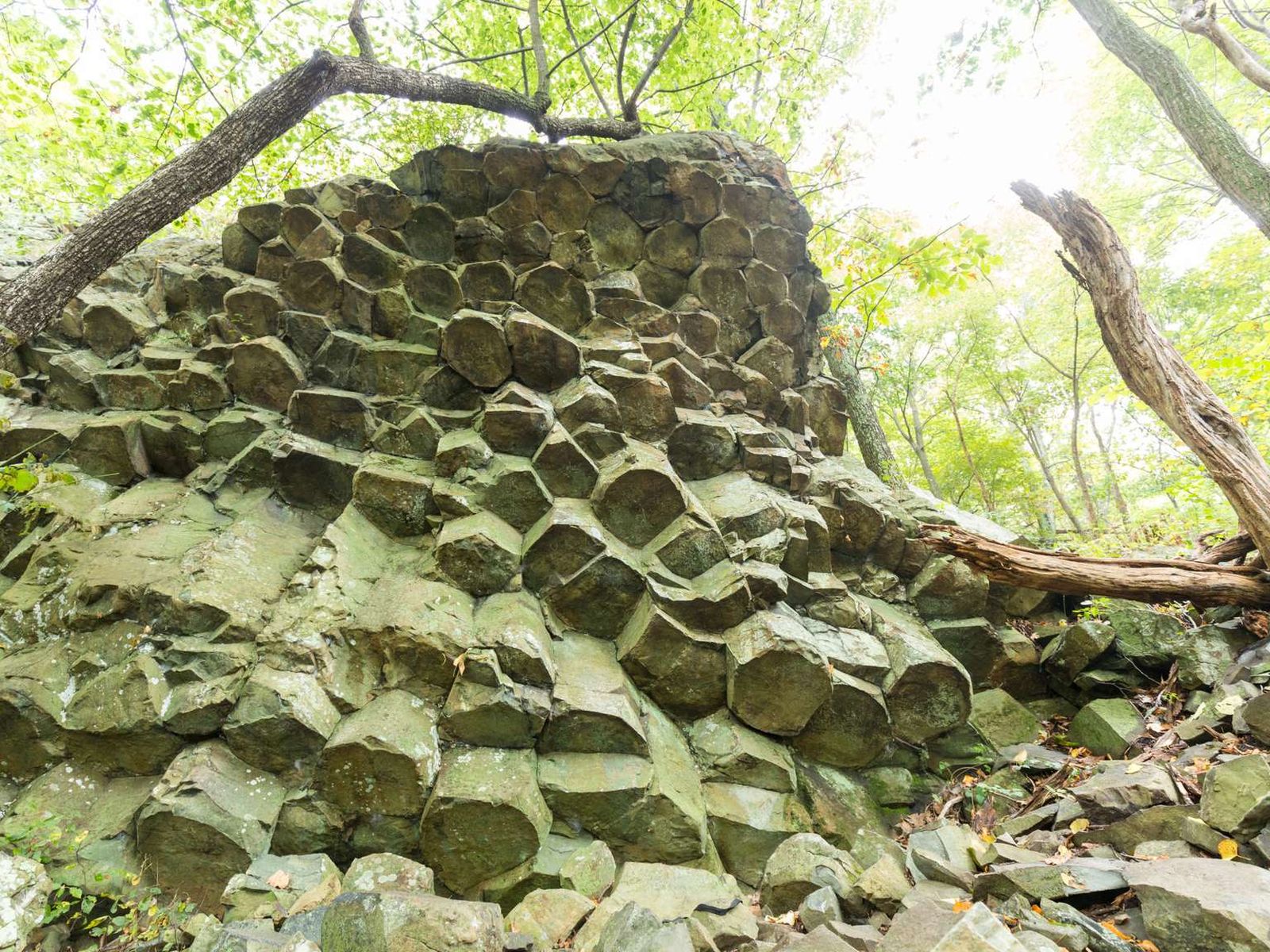
Compton Gap Parking Area (mile 10.4) | A hike through the forest along the Appalachian Trail to a western view and a great look at columnar jointing, an exciting geologic feature.
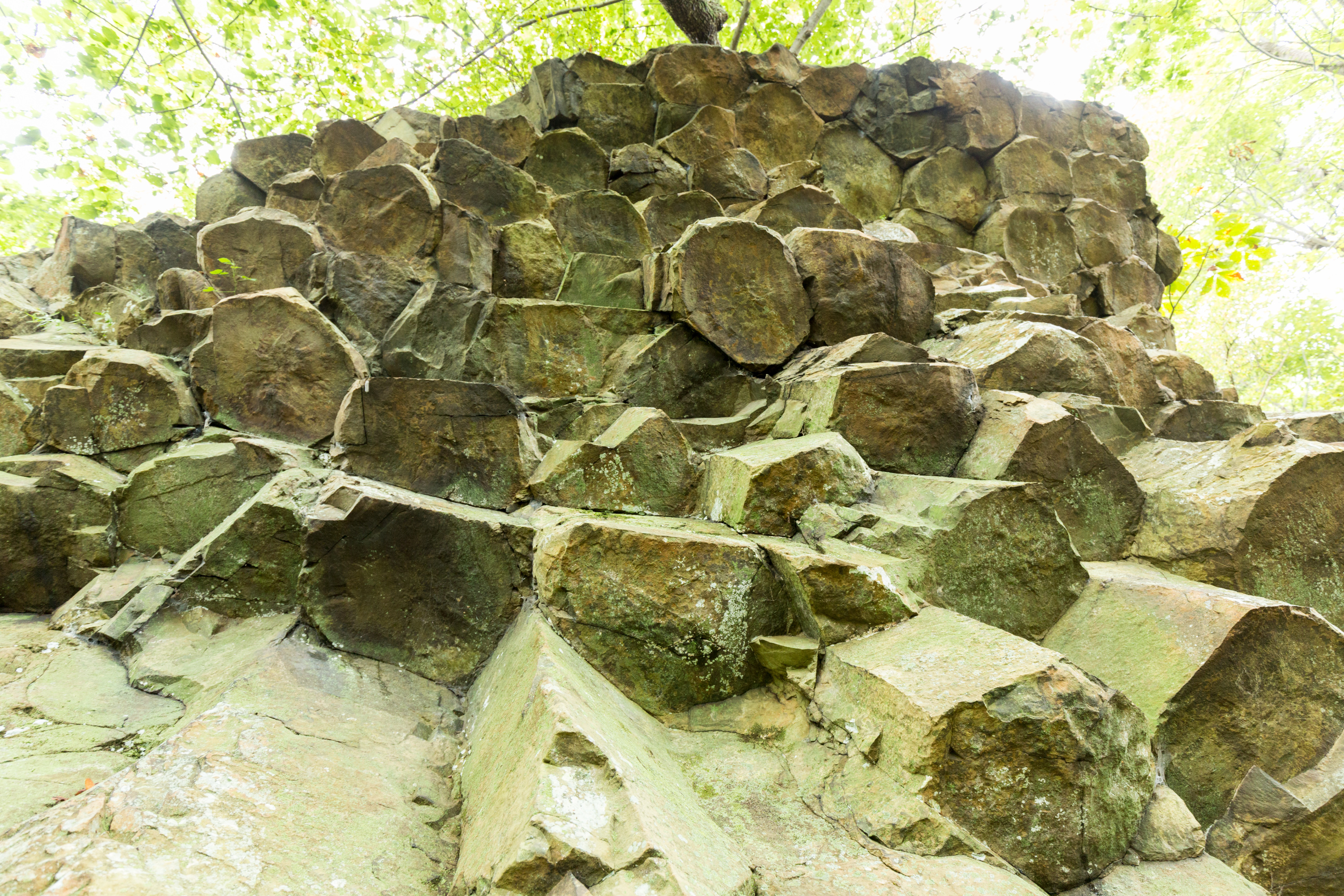
The Compton Gap Trailhead panel is a 36 by 54 inch color poster. On the upper left of the panel is a photograph taken of columnar jointing. The text reads, "Prismatic Features - Millions of years ago plates on the earth's surface in this area began pulling apart, and lava-at first it was black-colored basalt, but eventually it metamorphosed into the greenstone you see today- oozed up out of the earth and through the cracks between the plates. As the lava cooled, it shrank into intriguing six-sided shapes down through its depths, forming columns. Geologists call this columnar jointing. Take the Compton East hike (detailed below) to see an example of columnar jointing, one of the finest in the park." The photograph on the bottom left of the panel is of rocks and lichens in various shades of brown, rust, blue, green, and gray. The test reads, "Ancient Colors - Fort Windham Rocks and all the greenstone in this area are part of the Catoctin Formation, a series of related lava flows in Virginia, Maryland, and southern Pennsylvania. These rocks are being broken apart, little by little, by the power of ice and frost. Because the rocks at Fort Windham are covered with lichen and weathering rapidly, they feature some fascinating colors." The top right of the panel is a 20 by 20 inch topographic map of the hike to Compton Peak The trail is marked in yellow with a brown dashed line. The text reads, "Suggested Hikes: Hike #1: Compton Peak, West and East - 2.4-mile T-hike, moderate, 1.75 hours hiking time, 835-foot elevation gain. Cross Skyline Drive and begin at the Appalachian Trail (A.T.) post. Take the A.T. south to the trail post at the T-intersection. Go right at the post. Continue on the trail to the west viewpoint. Return to the intersection, and continue straight to the east viewpoint. The columnar jointing is underneath the east viewpoint; to see it, follow the blue blazes. This part of the trail is rough and rocky, but very short. When you reach the base of the cliff, look up to see the columnar jointing. Return the way you came, crossing Skyline Drive to reach the parking area." "Hike #2: Fort Windham Rocks - (This hike is marked in purple with a dashed line.) 0.8-mile round trip hike, easiest, ½ hour hiking time, 130-foot elevation gain. Follow the Appalachian Trail (A.T.) north to its intersection with the Dickey Ridge Trail. Turn left. In about 300 yards, explore Fort Windham Rocks on the right. Return the way you came." A red text box below the map gives important information that hikers need. The text reads, "Emergency 1-800-732-0911 (cell phone service is unreliable.) Before You Go! Pets must be on a leash at all times. Be sure you are physically able to complete the hike you've chosen. Take plenty of water-at least a quart per hour. - Be sure you know your route. Free maps are available at entrance stations, visitor centers, and www.nps.gov/shen. When you return from your hike, check for ticks. Be sure someone knows where you are and when to expect your return.
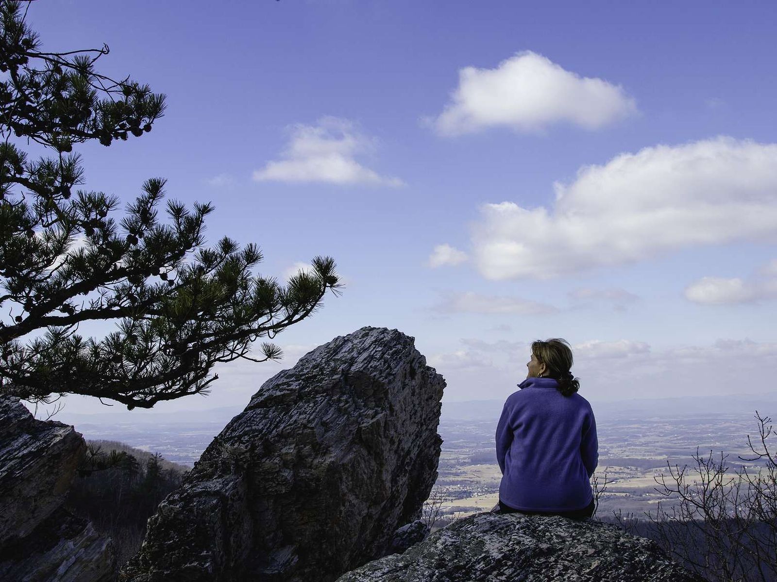
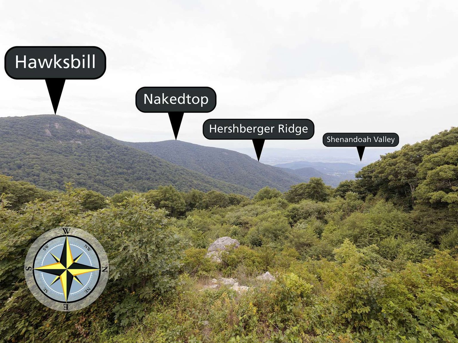
Facing west, with an elevation of 3,550 ft (1,082 m), Crescent Rock Overlook has some of the best views of Hawksbill Peak, the highest peak in Shenandoah, at 4,050 ft (1,234 m). An informational sign located at the overlook shares information about the establishment of Shenandoah National Park and the resettlement of former residents of the land.
The view from this overlook faces west. Vegetation covers the foreground and descends out of view. A large mountain on the left, Hawksbill, is the highest visible peak. To the right of Hawksbill and further away is Nakedtop Peak, which descends through Hershberger Ridge down to the Shenandoah Valley below. There is an interpretive sign at this overlook. The Crescent Rock Overlook interpretive sign is a 36 by 24 inch color graphic panel on a dark metal frame angled towards the viewer. The title text reads: "A Home Away From Home?" Above the title text is a black and white image of a family walking away from a house. There is a man closer to the camera wearing overalls and carrying household items. The man is looking back and there is a small white dog next to him. Toward where the man is looking and further back in the picture is a woman in a floral dress carrying a child and walking with two more children. The woman and children are walking through a wooden gate. All of the people in the picture are wearing coats and hats. The body text reads: "In late 1935, when Shenandoah National Park was officially established, 465 families remained on the land, most with no plans for relocation. The U.S. Department of Agriculture's Resettlement Administration was tapped to help. The government allocated funds to purchase 6,291 acres in seven locations; 343 were in Page County's Ida Valley just below you. The Ida plans called for 28 farms, each with a house and outbuildings for livestock. A cadre of "enumerators" conducted a detailed census of the families and deemed 293 "homestead prospects" meaning that, based on information gathered, these families had the means to pay the $5 monthly rent the first year and then purchase the property at its appraised value with a 40-year mortgage. Only 172 families chose to move from their mountain homes to homestead communities like the one below you; very few bought them a year later." Next to the text are two black and white images. The upper image depicts a group of men gathered around a truck with an open back. There are two men in the bed of the truck and nine on the ground. The men are loading items into the bed of the truck, which appears about half full. The caption reads, "The Dodson family, leaving their mountain home in 1937. The Civilian Conservation Corps helped load and transport their belongings to the Ida Valley, just below you. Today, you can still see the houses of the homestead community intended to be home to those forced to move." The lower image is a black and white image depicting a neighborhood with identical houses in a large cleared area of land with mountains in the distance. There is one house close to the front and a road leading into the distance with the other houses forking away from the main road at set intervals. There are about ten house separated at equal intervals as the road heads to the horizon. The mountains in the background are surrounded by fog. A black bar on the top of the graphic reads "Shenandoah National Park" on the left and on the right is the National Park Service Arrowhead symbol with the text "National Park Service/U.S. Department of the Interior"
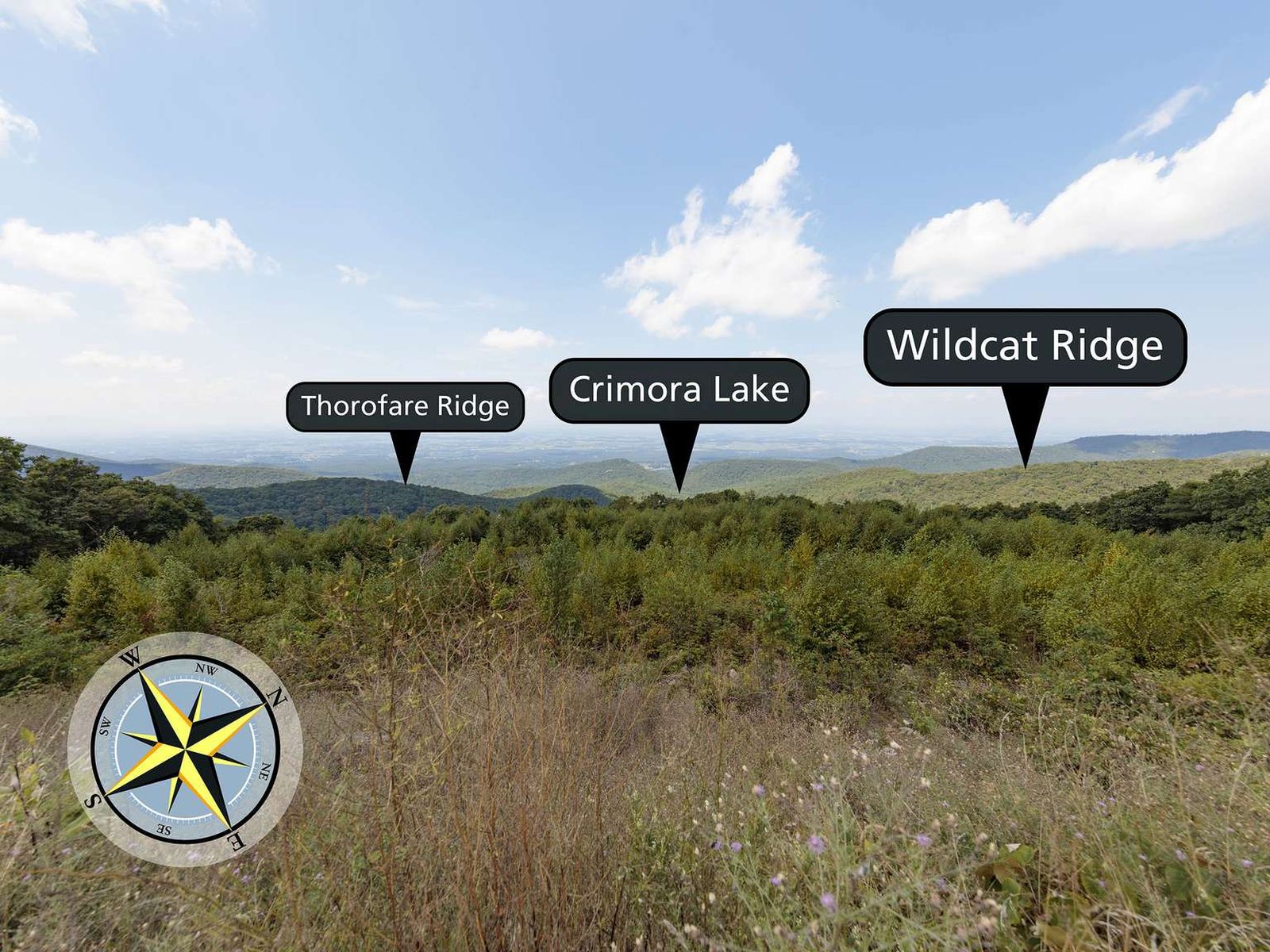
Facing northwest from an elevation of 2,985 ft (909 m), Crimora Lake Overlook is a good place to contemplate the industrial history of the Shenandoah Valley.
The view from this overlook faces northwest. Across a line of trees the mountains descend to the valley below. Closer and to the left is Thorofare Ridge. To the right and slightly further away is Wildcat Ridge. The location of Crimora Lake is straight ahead and down the hill. In the distance the mountains descend to the Shenandoah Valley.
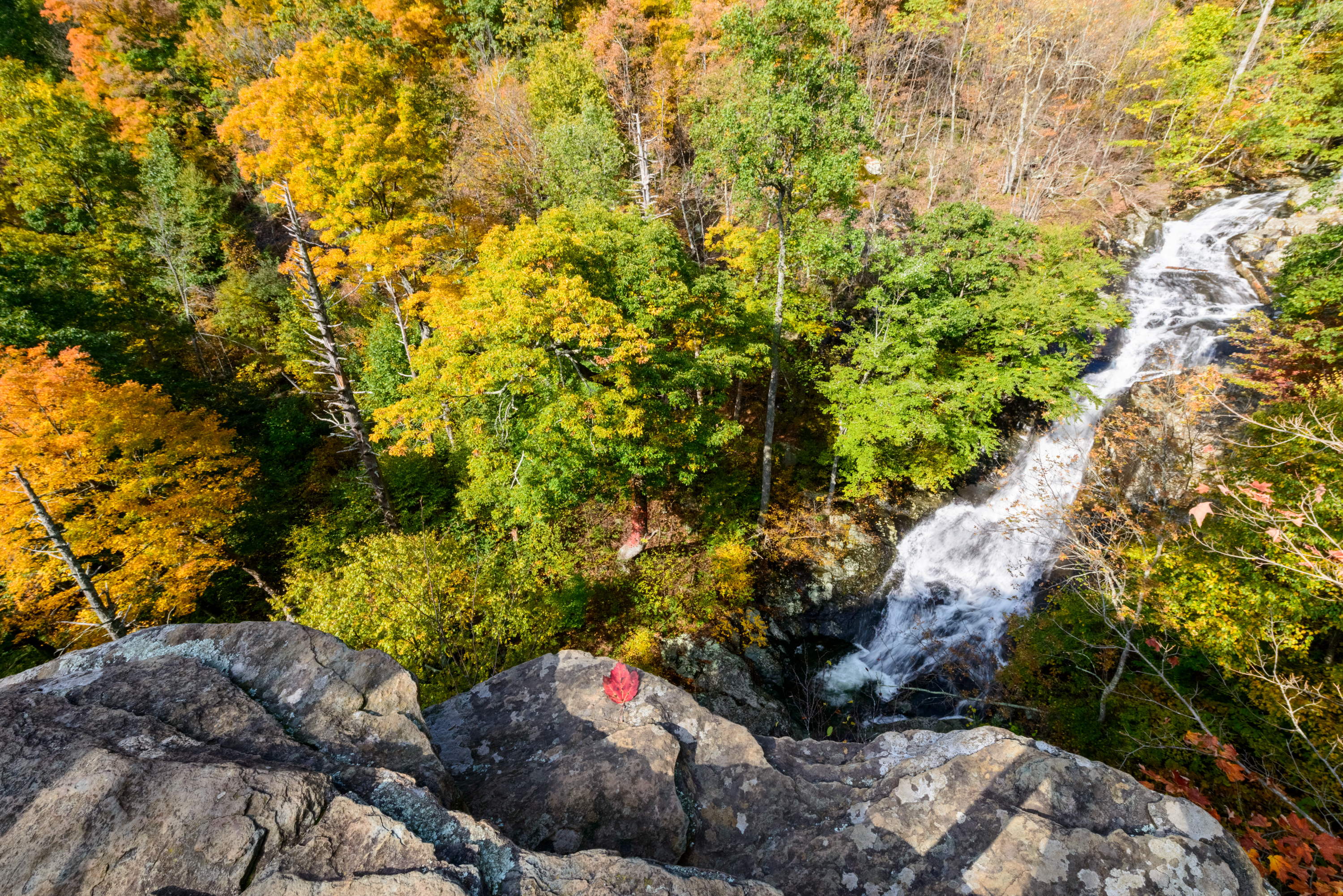
Dark Hollow Falls Parking Area (mile 50.7) | Pets are not allowed on this hike. This hike follows a stream to a beautiful waterfall, and is one of the Park’s most traveled trails. The trail is short, but very steep and rocky and the return hike is challenging!
The Dark Hollow Falls Trailhead panel is a 36 by 54 inch color poster. On the upper left of the panel is a photograph of the water cascading over the rocks of Dark Hollow. The text reads, "Water on the Rocks - The splashing stream that you follow to Dark Hollow Falls is a life saver. Starting from springs less than a mile away, the water nourishes plants, animals and humans. Park biologists keep an eye on changes in streams such as this one, to reduce negative impacts from humans and weather. Temperature changes of just a few degrees or high acid levels can make streams unlivable for many species. Once the water tumbles through Dark Hollow and leaves the Park, it joins other streams and rivers and passes through farmland, housing developments, towns, and industrial areas along its journey to Chesapeake Bay. Will it still be able to sustain life when it gets there?" There are four smaller pictures on the bottom left of the panel: a crayfish, purple-flowering raspberry, an ovenbird, and jewelweed. The text reads, "Who lives here? Take time to see and hear what's around you as you hike. In the stream, look for crayfish, brook trout, salamanders, and frogs. Listen for redstarts and ovenbirds. Bursts of color herald the seasons: trillium in spring, purple-flowering raspberry in summer, and jewelweed from summer into fall." The top right of the panel is a 20 by 20 inch topographic map of the hike to Dark Hollow Falls. The trail is marked in yellow with a brown dashed line. The text reads, "Suggested Hike: Hike: Dark Hollow Falls - 1.4-mile, round trip, moderate, 1 hours hiking time, 440-foot elevation gain. Follow the trail 0.75-mile to the base of the falls and return by the same route. If you plan to continue hiking beyond the falls, obtain a map from the visitor center for trail information. This trail is short, but very steep and rocky. The return climb is challenging! Sturdy shoes with gripping soles such as hiking boots and sneakers are best suited for the rocky terrain found on this hike. Stay on the trail and do not venture out onto the rocks near the waterfall. These rocks are very slippery and dangerous. The pathway that crosses Skyline Drive joins the Story of the Forest Trail which leads to Byrd Visitor Center (0.4-mile) and to Big Meadows Campground (0.66-mile). Pets are not allowed on this trail." A red text box below the map gives important information that hikers need. The text reads, "Emergency 1-800-732-0911 (cell phone service is unreliable.) Before You Go! Be sure you are physically able to complete the hike you've chosen. Be sure you know your route. Free maps are available at Entrance Stations, Visitor Centers, and www.nps.gov/shen. Take plenty of water-at least a quart per hour. Pets are not allowed on Dark Hollow Falls Trail. When you return from your hike, check for ticks. Be sure someone knows where you are and when to expect your return.
A beautiful spot to stop for a picnic in the northernmost area of the park. Equipped with tables, fire grates, water, restrooms, and plenty of room to relax! Closed in winter. Call 540-999-3500 for exact dates.
Dickey Ridge Picnic Grounds is on the west side of Skyline Drive. There is one roads that travels through the picnic ground. The picnic area is nested between that road and Skyline Drive. A sparsely wooded area with picnic tables and fire grates scattered about.
Dickey Ridge Visitor Center (mile 4.6) is located near Front Royal, Virginia, in the northern part of the Park. It's the ideal place for visitors entering through the Front Royal Entrance Station to find restrooms, information, a bookstore, publications, and maps. Right across Skyline Drive from the visitor center you will find the popular Fox Hollow Trail trailhead.
Byrd Visitor Center (mile 51) is located across from Big Meadows in the center of Shenandoah National Park. Available facilities include: restrooms, information desk, ranger programs, bookstore, publications, maps, and first aid. Within close proximity to countless activities and hikes, it's a great place to start your next trip!
MILE 41.7 | Pets are not allowed on this hike. This enjoyable hike brings you to an outstanding view of the Shenandoah Valley, Massanutten Mountain, and beyond.
Turk Mountain
MILE 94.1 | A hike to the 2,981’ summit of Turk Mountain, located in the Shenandoah Wilderness, that provides a wonderful view to the west.
Riprap - Wildcat Ridge
MILE 90 or 92.1 | This loop can be hiked from Riprap Parking or Wildcat Ridge Parking. It takes you through the forests of the Shenandoah Wilderness and over several stream crossings, while offering beautiful views of the hollows and valley to the west and north.
Nicholson Hollow
PARK BOUNDARY | An alternate option for visitors with pets who still wish to hike from the Old Rag parking area. This hike takes you through the Shenandoah Wilderness to Corbin Cabin, an old homesite built by a former resident, and features several stream crossings along the way.
Knob Mountain - Jeremys Run
Elkwallow Wayside (mile 24) | This hike goes around a beautiful area of the Park featuring one of the most picturesque streams in Shenandoah. The majority of this hike is in the Shenandoah Wilderness.
Hazel River Falls
Meadow Spring Parking Area (mile 33.5) | A trail that leads you into the Shenandoah Wilderness to an exceptional waterfall.
Chimney Rock
Riprap Parking Area (mile 90) | An out-and-back hike into the Shenandoah Wilderness ending at Chimney Rock, an excellent viewpoint with some very interesting geological features.
Cedar Run - Whiteoak Circuit
Hawksbill Gap Parking Area (mile 45.6) | This hike is very challenging, although those who do it are rewarded with exceptional cascades and waterfalls. You will also hike through the Shenandoah Wilderness along the Cedar Run Trail.
Rose River Falls
MILE 49.4 | A hike to a dazzling 67' waterfall. For most of this hike, you’ll be on a beautiful trail in the Shenandoah Wilderness.
Overall Run Falls
MILE 22.2 | A hike into federally designated Wilderness to a view of the highest waterfall in the Park at 93 feet. Unless rain is plentiful, Overall Run Falls may have minimal to no water flow.
Doyles River Falls
Doyles River Parking Area (mile 81.1) | This beautiful trek takes you along cool, clear mountain streams to two unique waterfalls.
Browns Gap
Browns Gap Parking Area (mile 83) | This circuit hike leads you to Upper and Lower Doyles River Falls, as well as Jones Run Falls.
Marys Rock From Meadow Spring
MILE 33.5 | This alternate route to Marys Rock Summit offers an easier and shorter trek to the same incredible westward views of the Shenandoah Valley. Along the way, hikers will pass by the remnants of the former Meadow Spring Shelter as well as beautiful azalea blooms in season.
Marys Rock Summit
MILE 31.6 | Many legends surround the name of this hike, but there is no denying the beautiful westward views that it provides of the Shenandoah Valley and Massanutten Mountain.
Hawksbill Summit via Upper Hawksbill
MILE 46.5 | A hike to the top of Shenandoah’s highest peak, offering 360-degree views of the Shenandoah Valley, the Blue Ridge Mountains, and the Virginia Piedmont.
Hawksbill Summit
Hawksbill Gap Parking Area (mile 45.5) | A shorter, yet steeper route to Shenandoah’s highest peak. The viewing platform on top of Hawksbill offers a magnificent 360-degree panoramic view of the Shenandoah Valley, the Blue Ridge Mountains, and the Virginia Piedmont.
Hawksbill Loop
Hawksbill Gap Parking Area (mile 45.5) | A circuit hike to Shenandoah’s highest peak. The viewing platform on top of Hawksbill offers a magnificent 360-degree view of the Shenandoah Valley, the Blue Ridge Mountains, and the Virginia Piedmont.
Old Rag Summit via Berry Hollow
Berry Hollow Parking Area (Park Boundary) | Visitors must obtain an Old Rag day-use ticket in advance of this hike. Pets are not allowed. Old Rag is a popular, strenuous hike with sweeping views. This route starts from the Berry Hollow parking area and allows you to get to the summit without having to navigate the rock scramble.
Old Rag Circuit
PARK BOUNDARY | Visitors must obtain an Old Rag day-use ticket in advance of this hike. Pets are not allowed. Old Rag is a popular, very strenuous hike with sweeping views and several scrambles across large rocks. This route starts from the Old Rag parking area on the boundary of the Park.
Fox Hollow Trail
Dickey Ridge Visitor Center (Mile 4.6) | Pets are not allowed on this hike. Discover the cultural history of Shenandoah National Park as you pass by historic rock walls, a cemetery, and periwinkles planted by former residents. This hike is also a designated TRACK Trail, featuring a self-guided brochure designed for kids.
Mill Prong - Laurel Prong Loop
MILE 52.8 | A circuit hike to Camp Rapidan, the rustic getaway of President Herbert Hoover and First Lady Lou Henry Hoover. Today, this restful spot features exhibits on the First Couple and their perspectives.
Rapidan Camp
MILE 52.8 | A hike, featuring three stream crossings, to the rustic getaway of President Herbert Hoover and First Lady Lou Henry Hoover. Today, this restful spot features exhibits on the First Couple and their perspectives.
Limberlost
Limberlost Parking Area (mile 43) | An ADA accessible path through the forest with mountain laurel in the springtime and an example of a columnar jointing geological feature. This hike is also a designated TRACK Trail, featuring a self-guided brochure designed for kids.
Blackrock Summit
Blackrock Parking Area (mile 84.4) | A short hike to a viewpoint on top of a rocky talus slope with incredible views of the Shenandoah Valley, Massanutten Mountain, and beyond. This hike is also a designated TRACK Trail, featuring a self-guided brochure designed for kids.
Stargaze in Shenandoah
Shenandoah National Park has distinctly accessible night skies that make stargazing and astrophotography a fun and insightful activity for all ages.
All About Hiking - Start Here!
With over 500 miles of trails in Shenandoah National Park, chances are high that you'll be lacing up your hiking boots at some point on your next trip here.
Sugarloaf Loop
MILE 22 | Follow the trail to a viewpoint. In the early summer, the showy white flowers of mountain laurel bloom in abundance here.
Jones Run Falls
Jones Run Parking Area (mile 84.1) | This hike takes you over a mountain stream, through the forest, and beside a 42’ waterfall.
Hightop Summit
Hightop Mountain Parking Area (mile 66.7) | Wind your way up a ridge on this hike to a rocky viewpoint that stands at 3,296 feet.
Frazier Discovery Trail
Loft Mountain Wayside (mile 79.5) | Pets are not allowed on this hike. This hike features several picturesque overlooks as it passes through woodlands of varying ages on Loft Mountain.
Fort Windham Rocks
Compton Gap Parking Area (mile 10.4) | A short hike along the Appalachian Trail that leads to an interesting geologic feature.
Dark Hollow Falls
Dark Hollow Falls Parking Area (mile 50.7) | Pets are not allowed on this hike. This hike follows a stream to a beautiful waterfall, and is one of the Park’s most traveled trails. The trail is short, but very steep and rocky and the return hike is challenging!
Compton Peak
Compton Gap Parking Area (mile 10.4) | A hike through the forest along the Appalachian Trail to a western view and a great look at columnar jointing, an exciting geologic feature.
Bearfence Viewpoint
MILE 56.4 | Pets are not allowed on this hike. This route takes you to a 180-degree view of the Shenandoah Valley without a rock scramble.
Whiteoak Falls (Upper)
MILE 42.6 | This challenging hike to cascades and waterfalls has been popular since the early days of Skyland Resort. This particular hike goes to the upper falls before returning.
Traces Trail
MILE 22.2 | A hike that follows a trail around Mathews Arm Campground. Along the way, you’ll see traces left behind by former residents of the area.
Story of the Forest
MILE 51 | Pets are not allowed on this hike. An easier stroll through the woods that passes next to the Big Meadows Air Quality Station, an important place for scientists and researchers to learn about air quality in Shenandoah.
South River Falls Observation Point
MILE 62.7 | From the South River Picnic Grounds, this hike leads you through a verdant forest alive with a wide variety of plant and animal life to a stone-walled observation point overlooking an 83’ waterfall.
Snead Farm Loop
MILE 5.1 | Hike through old apple orchards and farmlands to an historic barn on the former Snead homesite.
Pass Mountain Loop
MILE 31.6 | A hike along the Appalachian Trail to a shelter. Be on the lookout for wildflowers and birds through the fairly open woods along the trail!
Millers Head
MILE 42.5 | From the Skyland amphitheater, take this hike to a spectacular viewpoint at the site of a former fire tower.
Whiteoak Falls (Lower)
PARK BOUNDARY | An easier hike to the base of the lower falls in Whiteoak Canyon. Note that a Park entrance fee is still required.
Lands Run Falls
MILE 9.2 | A short hike down a fire road to a series of cascades that descend about 80 feet into a gorge. Note that it may not have water in dry seasons.
Appalachian Trail - Tanners Ridge Road
MILE 52.8 | A fairly level hike that takes you through a former homestead on the famous Appalachian Trail.
Bearfence Rock Scramble
MILE 56.4 | Pets are not allowed on this hike. An exhilarating rock scramble leads to a magnificent 360-degree view of the Virginia Piedmont and Shenandoah Valley.
South River Falls
MILE 62.7 | From the South River Picnic Grounds, this route is a circuit hike that takes you to an observation point overlooking an 83’ waterfall. A great hike for wildflower and bird enthusiasts, alike!
Little Devils Stairs Loop
MILE 19.4 | A journey into a rocky gorge with some very rewarding, yet steep, sections along a stream.
Lewis Falls Trail
MILE 51.2 | Leaving from Big Meadows amphitheater, this hike leads to an observation point over a beautiful 81’ waterfall.
Go Birdwatching in Shenandoah
Birdwatching is a fun activity that the whole family can enjoy, and Shenandoah provides the perfect habitat to spot a variety of different species, including those colorful, neotropical migratory birds!
Tours
Count: 6
A Hike Up Stony Man
What makes a mountain? Is it more than just the rocks underfoot? This hike is a 1.6 mile circuit up to the summit of Stony Man Mountain and back down. Classified as "easy" Stony Man does have a total ascent of 340 feet. Hikers will tour past features, both natural and historic, and take a closer glimpse at the building blocks that make this mountain. Fascinating geology, everchanging trees and their inhabitants, and remnants of mining and other pre-Park life on this mountain, hikers will leave with the und
Big Meadows Civilian Conservation Corps Camp
Shenandoah National Park hosted 11 Civilian Conservation Corps (CCC) Camps between 1933 and 1941. The CCC was a popular New Deal Program designed to put young men and women to work during the Great Depression. One of the camps was established at Big Meadows (mile 51). Take an easy walking tour of the camp and follow in the steps of the men who built Shenandoah. Park at the visitor center, cross Skyline Drive, and then walk to the far right edge of the meadow.
Fox Hollow Trail
The Fox family once called this area home. Remnants of their lives and the impact they had on this land are still evident. This hike is a 1.2-mile circuit. It is classified "easy" but it does have a gentle incline (310' elevation gain). The tour will introduce you to the Fox family as you pass through a former farm, and by the family cemetery and other evidence of a life before Shenandoah. Join us as we gratefully acknowledge the sacrifice of those who once lived here.
Limberlost Accessible Trail
Limberlost Trail has provided access to nature since before Shenandoah was a National Park. As an ADA accessible trail, this 1.3-mile circuit leads guests gently through the forest. Surrounded by wildflowers, bird activity, amazing geology, and a dose of history, the Limberlost provides access to hikers of all ages and abilities to witness firsthand the storied past, present, and future of Shenandoah National Park.
Pinnacles Picnic Grounds
Use this tour to locate accessible parking spaces and picnic tables.
Rapidan Camp
Nestled deep in a hollow at the headwaters of the Rapidan River in Shenandoah National Park is a little piece of history. Rapidan Camp was the beautiful, rustic getaway of President Herbert Hoover and First Lady Lou Henry Hoover. Experience this serene spot yourself and explore its history through this self-guided tour. The camp is not accessible by private vehicle. Hike in from Milam Gap or join a Ranger Tour.